Glacial Geomorphology and Preliminary Glacier Reconstruction in the Jablanica Mountain, Macedonia, Central Balkan Peninsula

 , ,
, ,  ,
,
Abstract
:1. Introduction
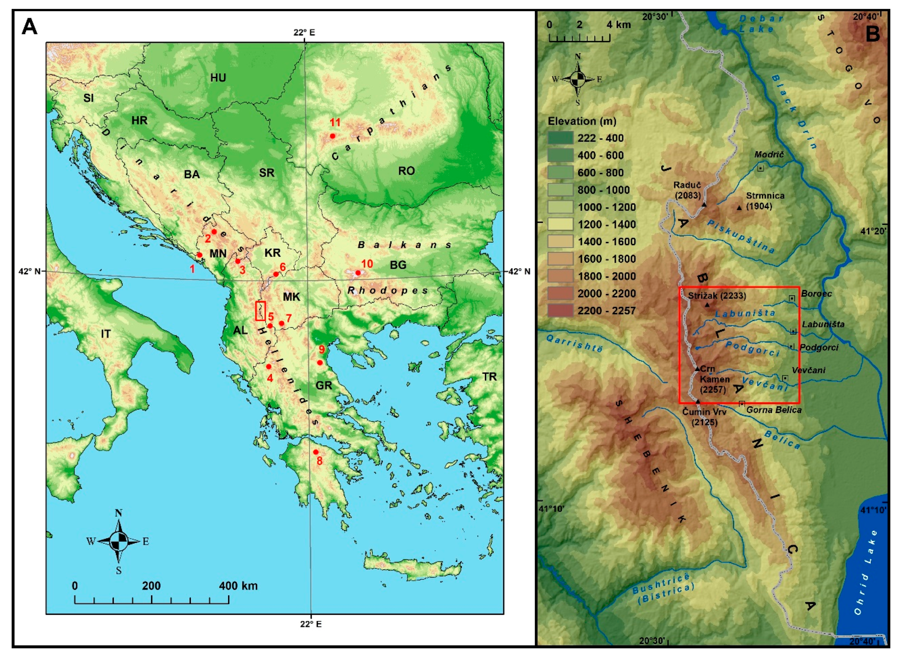
2. Study Area
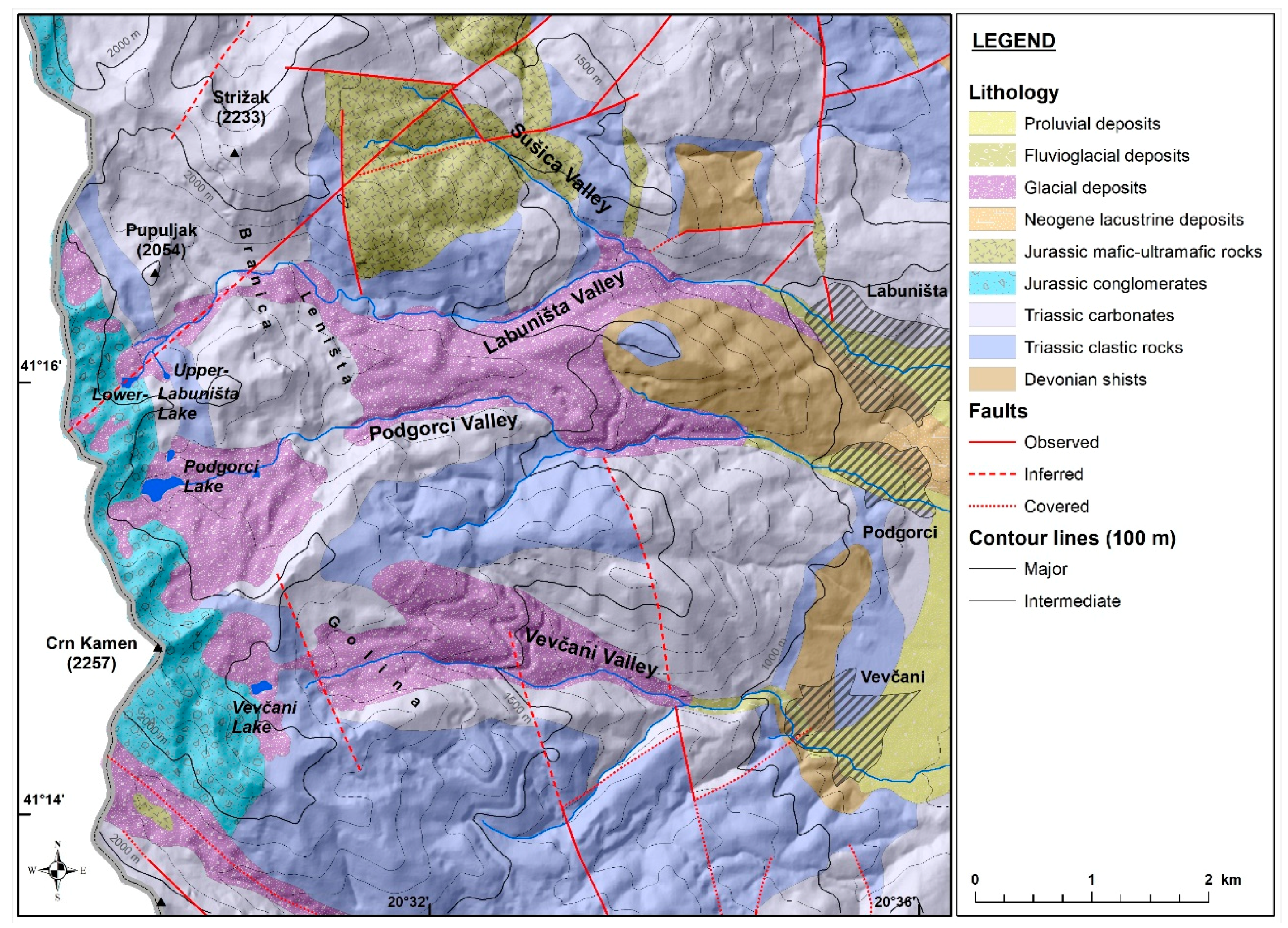
2.1. Location and Geological Setting of the Jablanica Mountain
2.2. Introduction to the Glacial Geomorphology of the Study Area and Previous Results
2.3. The Climate of the Jablanica Mountain
3. Methodology
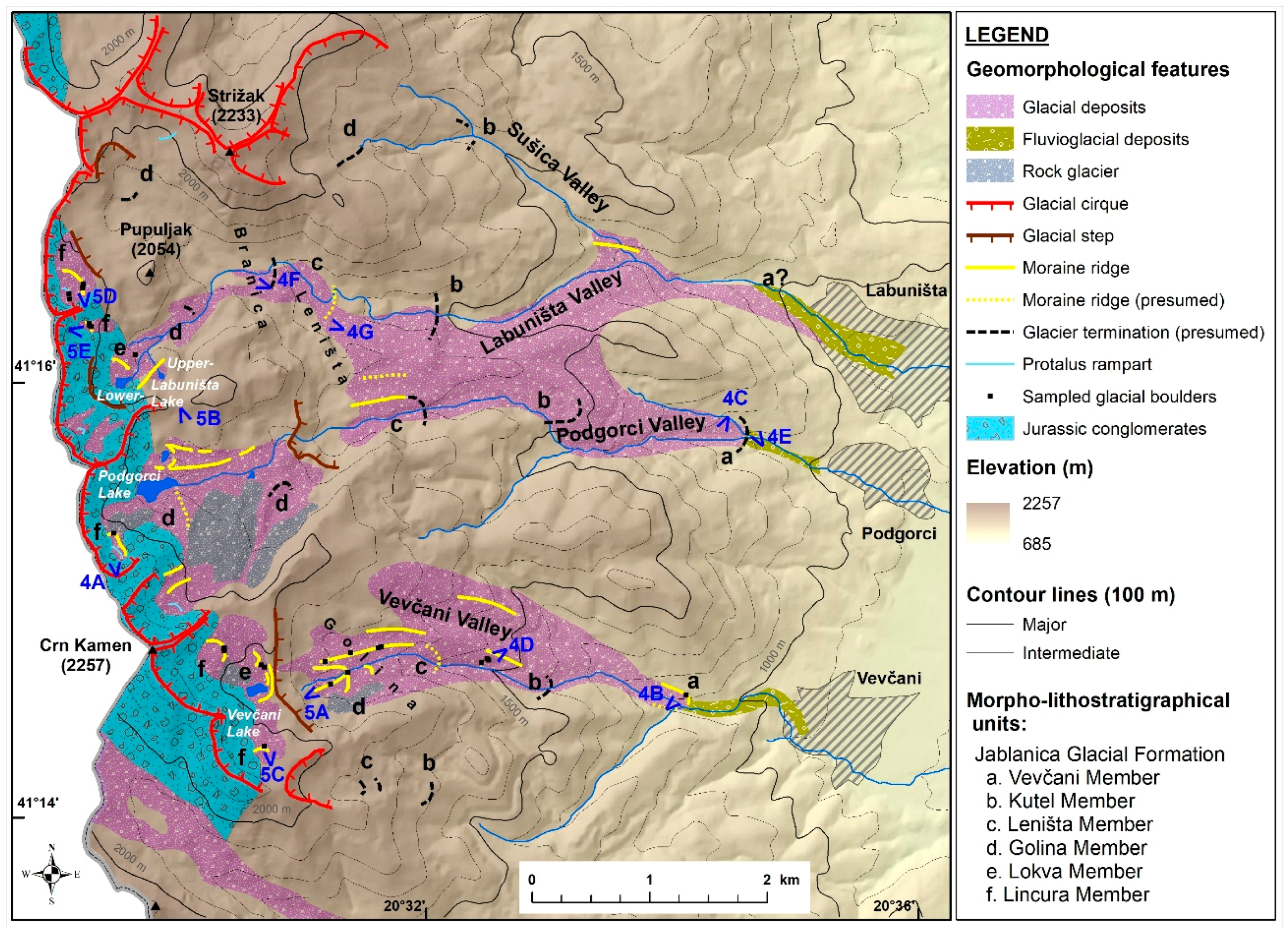
3.1. Geomorphological Mapping
3.2. Glacier Reconstruction
3.3. Calculation of the Paleo-ELAs
4. Results
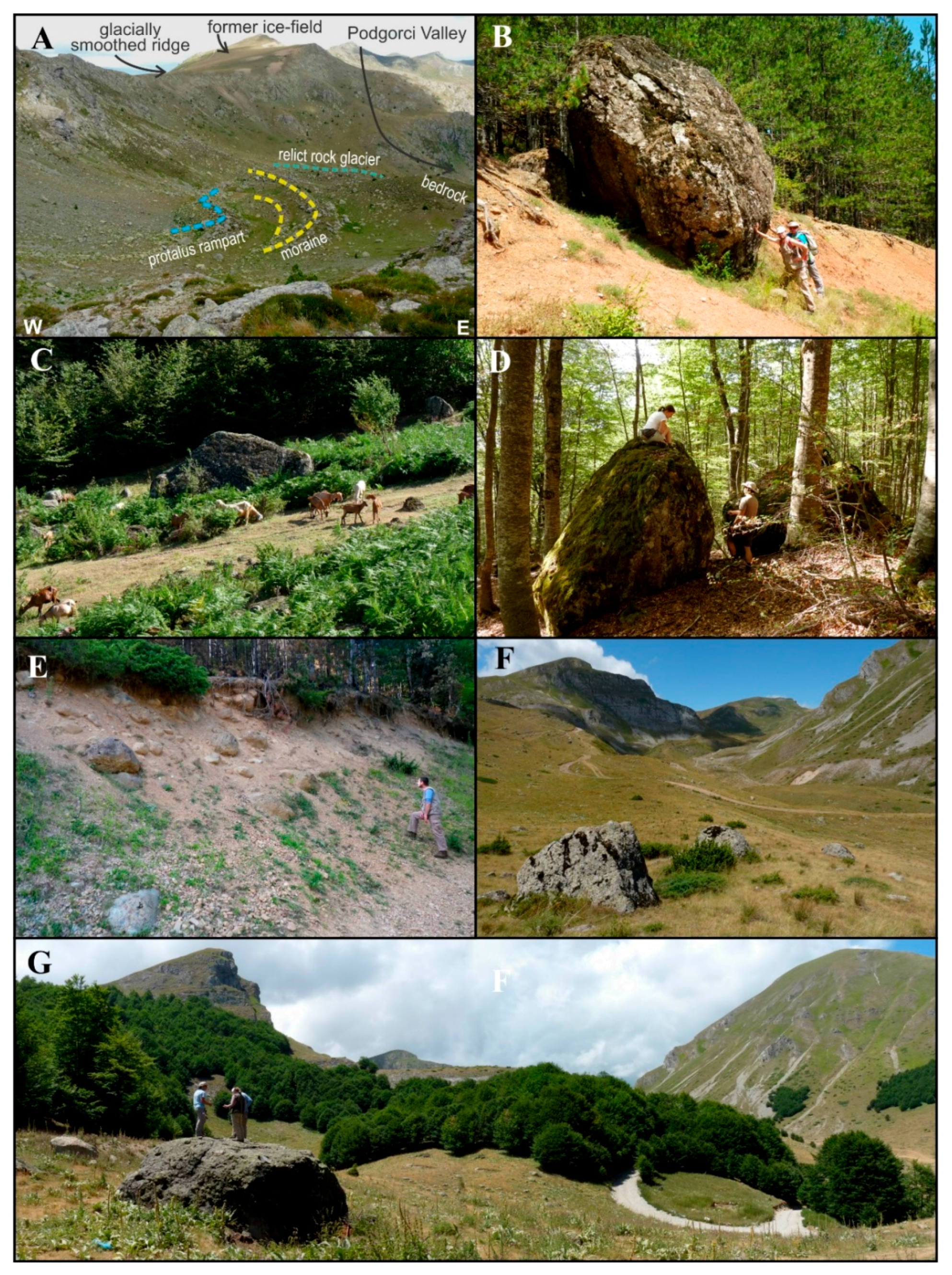
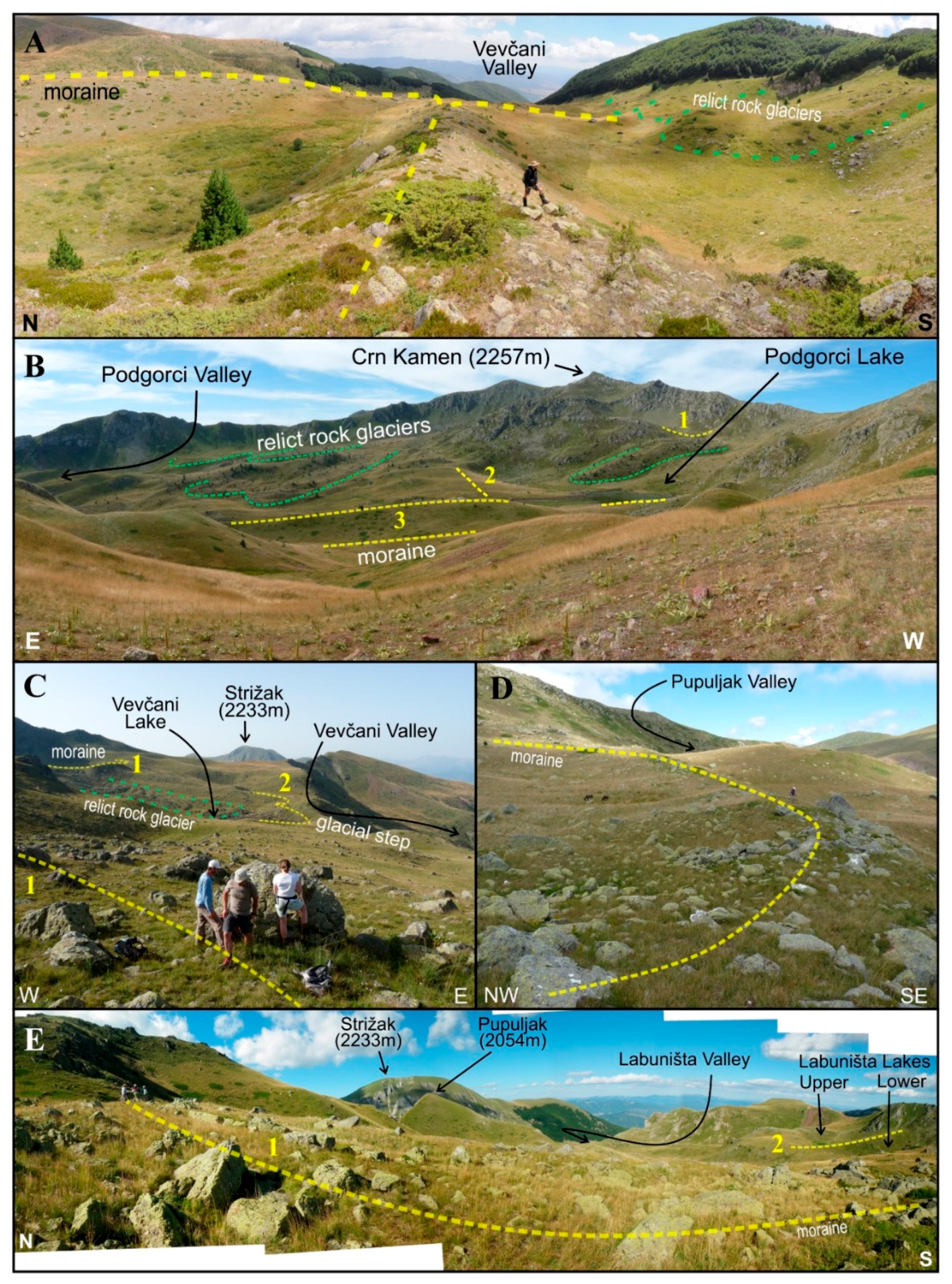
4.1. Glacial Morphology and Deposits
4.1.1. Vevčani Member
4.1.2. Kutel Member
4.1.3. Leništa Member
4.1.4. Golina Member
4.1.5. Lokva Member
4.1.6. Lincura Member
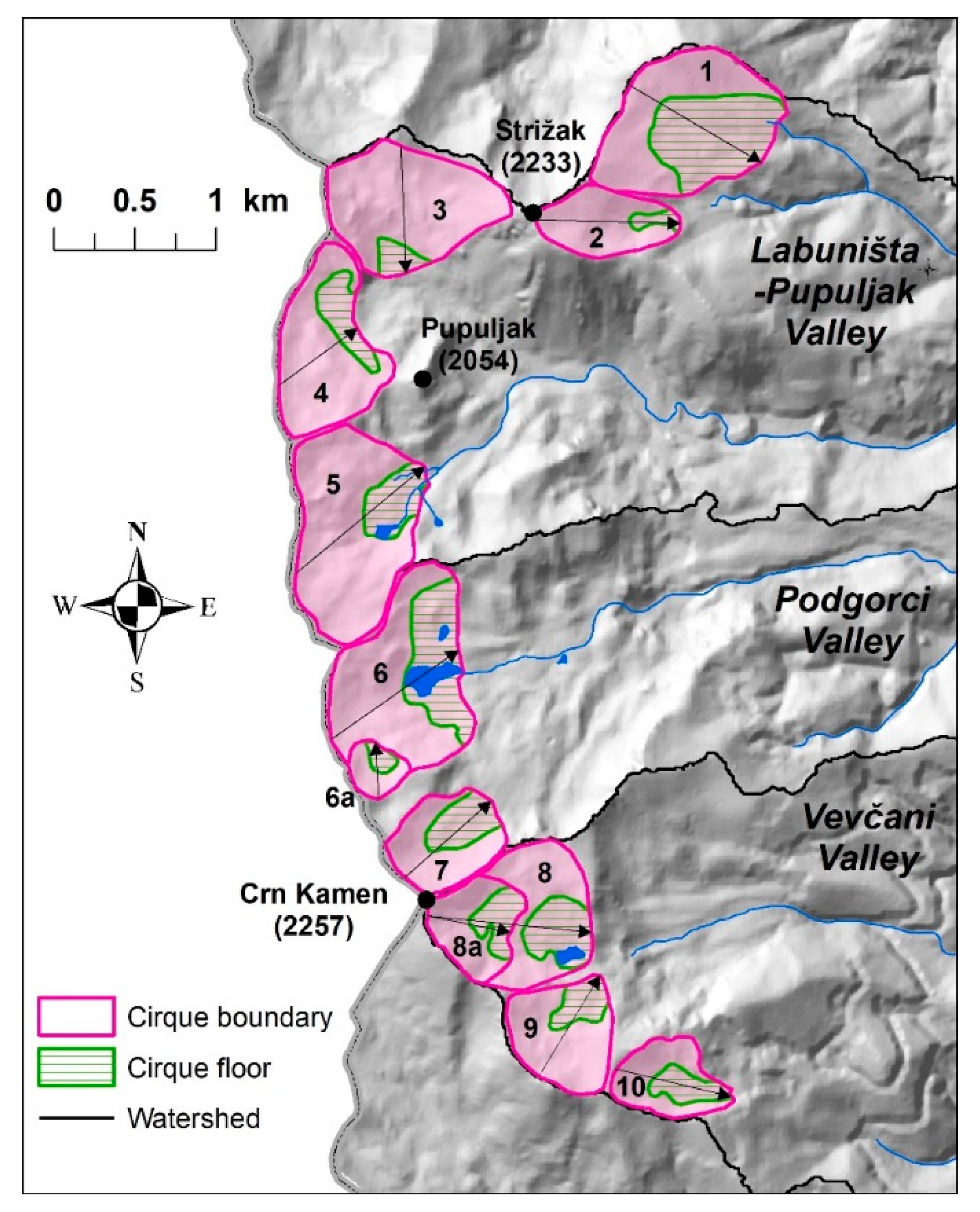
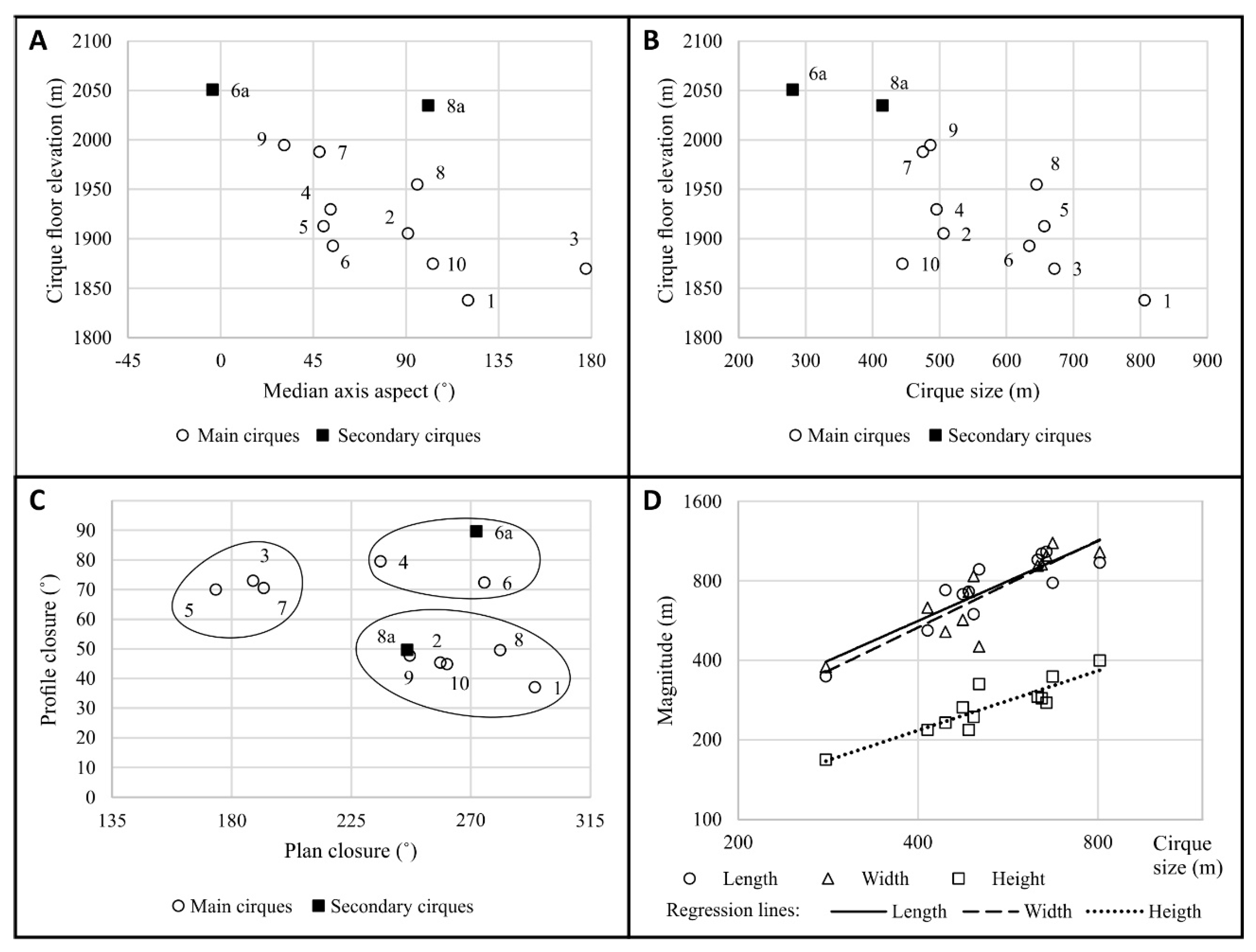
4.2. Cirque Morphometry
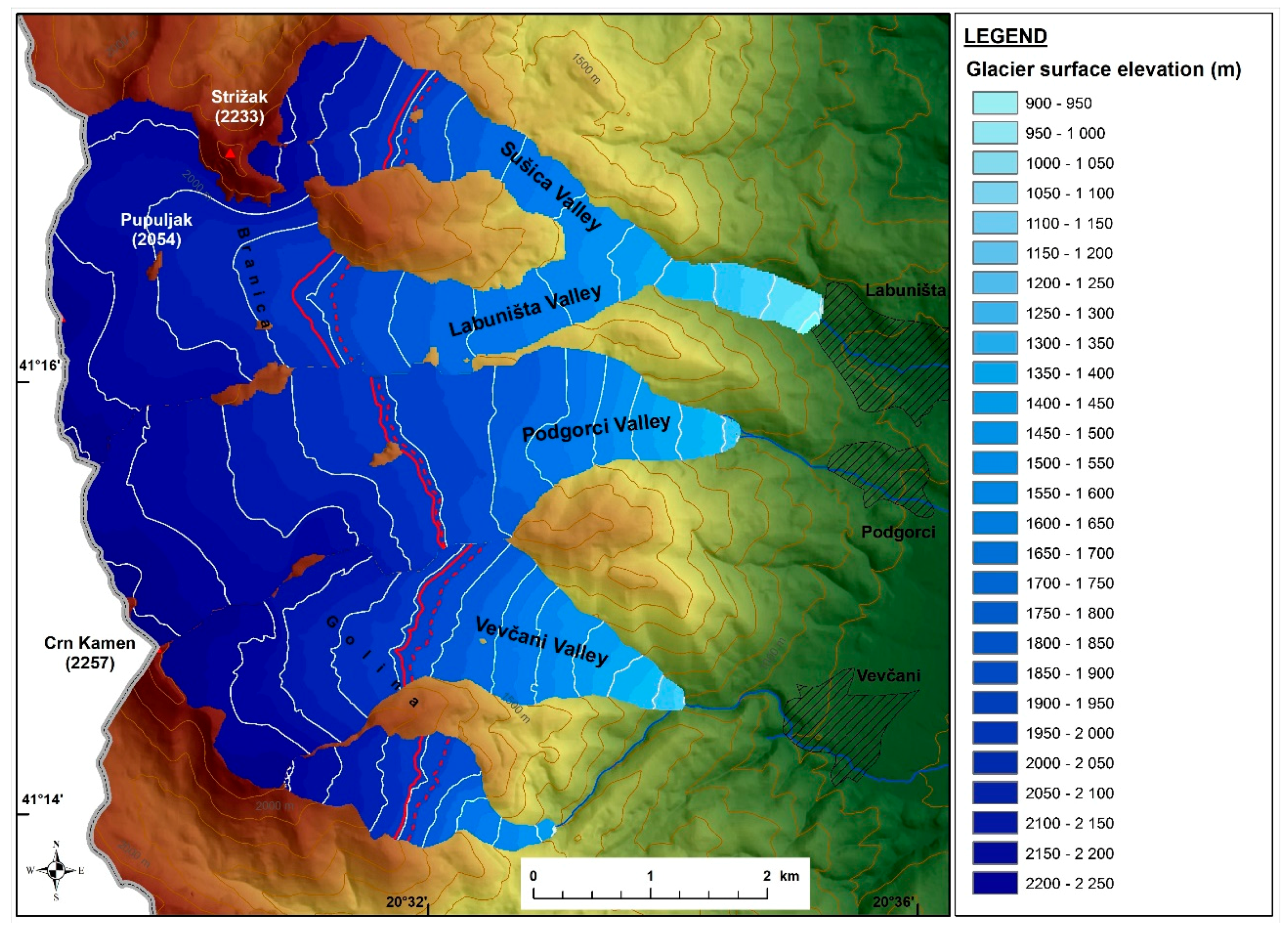
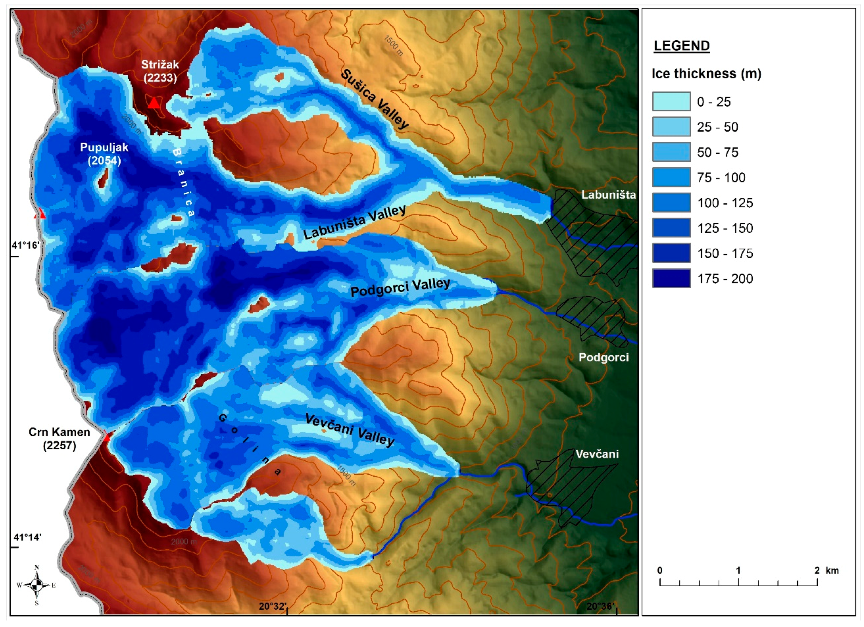
4.3. Glacier Reconstruction
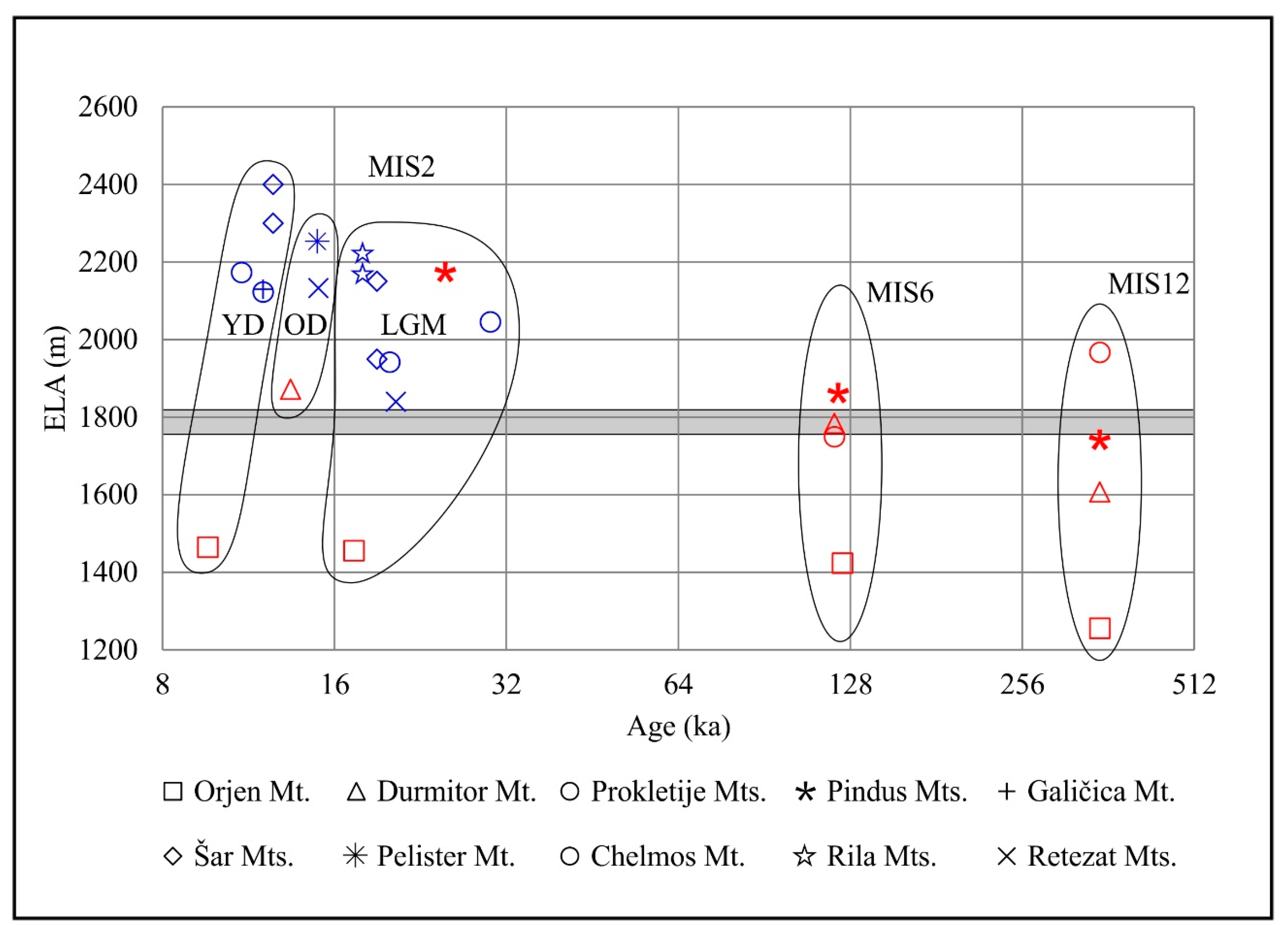
5. Discussion
6. Conclusions
Author Contributions
Funding
Acknowledgments
Conflicts of Interest
References
- Knight, P.G. (Ed.) Glacier Science and Environmental Change; John Wiley & Sons: Hoboken, NJ, USA, 2008; ISBN 978-1-405-10018-2. [Google Scholar]
- Kuhlemann, J.; Rohling, E.J.; Krumrei, I.; Kubik, P.; Ivy-Ochs, S.; Kucera, M. Regional Synthesis of Mediterranean Atmospheric Circulation During the Last Glacial Maximum. Science 2008, 321, 1338–1340. [Google Scholar] [CrossRef] [PubMed]
- Carr, S.J.; Lukas, S.; Mills, S.C. Glacier reconstruction and mass-balance modelling as a geomorphic and palaeoclimatic tool. Earth Surf. Process. Landf. 2010, 35, 1103–1115. [Google Scholar] [CrossRef]
- Cvijić, J. Das Rilagebirge und seine ehemalige Vergletscherung. Z. Ges. Erdkd. Berl. 1898, 33, 200–253. (In German) [Google Scholar]
- Cvijić, J. L’époque glaciaire dans la péninsule des Balkans. Ann. Géogr. 1917, 141, 189–218. (In French) [Google Scholar] [CrossRef]
- Dedijer, J. Traces glaciaires en Albanie et en Nouvelle Serbie. Géogr. Bull. Soc. Géogr. 1917, 31, 325–337. (In French) [Google Scholar]
- Messerli, B. Die eiszeitliche und die gegenwartige Vertgletscherung im Mittelemeeraum. Geogr. Helv. 1967, 22, 105–228. (In German) [Google Scholar] [CrossRef]
- Hughes, P.D.; Woodward, J.C. Quaternary Glaciation in the Mediterranean Mountains: A new synthesis. In Quaternary Glaciation in the Mediterranean Mountains; Hughes, P.D., Woodward, J.C., Eds.; Special Publications 433; Geological Society: London, UK, 2016; pp. 1–23. [Google Scholar]
- Hughes, P.D.; Woodward, J.C.; Gibbard, P.L.; Macklin, M.G.; Gilmour, M.A.; Smith, G.R. The glacial history of the Pindus mountains, Greece. J. Geol. 2006, 114, 413–434. [Google Scholar] [CrossRef]
- Hughes, P.D.; Woodward, J.C.; van Calsteren, P.C.; Thomas, L.E.; Adamson, K. Pleistocene ice caps on the coastal mountains of the Adriatic Sea: Palaeoclimatic and wider palaeoenvironmental implications. Quat. Sci. Rev. 2010, 29, 3690–3708. [Google Scholar] [CrossRef]
- Hughes, P.D.; Woodward, J.C.; van Calsteren, P.C.; Thomas, L.E. The glacial history of the Dinaric Alps, Montenegro. Quat. Sci. Rev. 2011, 30, 3393–3412. [Google Scholar] [CrossRef]
- Smith, G.W.; Nance, R.D.; Genes, A.N. Pleistocene glacial history of Mount Olympus, Greece: Neotectonic uplift, equilibrium line elevations, and implications for climatic change. In Postcollisional Tectonics and Magmatism in the Mediterranean Region and Asia; Dilek, Y., Pavlides, S., Eds.; Special Paper 409; Geological Society of America: Boulder, CO, USA, 2006; pp. 157–174. [Google Scholar]
- Woodward, J.C.; Macklin, M.G.; Smith, G.R. Pleistocene glaciation in the mountains of Greece. In Quaternary Glaciations—Extent and Chronology. Part I; Ehlers, J., Gibbard, P.L., Eds.; Elsevier Science: New York, NY, USA, 2004; pp. 155–173. [Google Scholar]
- Kuhlemann, J.; Milivojevic, M.; Krumrei, I.; Kubik, P.W. Last glaciation of the Šara range (Balkan peninsula): Increasing dryness from the LGM to the Holocene. Austrian J. Earth Sci. 2009, 102, 146–158. [Google Scholar]
- Kuhlemann, J.; Gachev, E.; Gikov, A.; Nedkov, S.; Krumrei, I.; Kubik, P. Glaciation in the Rila mountains (Bulgaria) during the Last Glacial Maximum. Quat. Int. 2013, 293, 51–62. [Google Scholar] [CrossRef]
- Ribolini, A.; Bini, M.; Isola, I.; Spagnolo, M.; Zanchetta, G.; Pellitero, R.; Mechernich, S.; Gromig, R.; Dunai, T.J.; Wagner, B.; et al. An Oldest Dryas glacier expansion on Mount Pelister (Former Yugoslavian Republic of Macedonia) according to 10Be cosmogenic dating. J. Geol. Soc. Lond. 2017, 175, 100–110. [Google Scholar] [CrossRef]
- Smith, G.W.; Nance, R.D.; Genes, A.N. Quaternary Glacial History of Mount Olympus. Geol. Soc. Am. Bull. 1997, 109, 809–824. [Google Scholar] [CrossRef]
- Pope, R.J.; Hughes, P.D.; Skoutsos, E. Glacial history of Mt Chelmos, Peloponnesus, Greece. In Quaternary Glaciation in the Mediterranean Mountains; Hughes, P.D., Woodward, J.C., Eds.; Special Publications 433; Geological Society: London, UK, 2017; pp. 211–236. [Google Scholar]
- Gromig, R.; Mechernich, S.; Ribolini, A.; Wagner, B.; Zanchetta, G.; Isola, I.; Bini, M.; Dunai, T. Evidence for a Younger Dryas deglaciation in the Galicica Mountains (FYROM) from cosmogenic 36Cl. Quat. Int. 2018, 464, 352–363. [Google Scholar] [CrossRef]
- Marjanac, T.; Marjanac, L. The extent of middle Pleistocene ice cap in the coastal Dinaric Mountains of Croatia. Quat. Res. 2016, 85, 445–455. [Google Scholar] [CrossRef]
- Velić, J.; Velić, I.; Kljajo, D.; Protrka, K.; Škrabić, H.; Špoljar, Z. A geological overview of glacial accumulation and erosional occurrences on the Velebit and the Biokovo Mts., Croatia. Min. Geol. Pet. Eng. Bull. 2017, 32, 77–96. [Google Scholar] [CrossRef]
- Gachev, E.; Stoyanov, K.; Gikov, A. Small glaciers on the Balkan Peninsula: State and changes in the last several years. Quat. Int. 2016, 415, 33–54. [Google Scholar] [CrossRef]
- Hughes, P.D. Twenty-first Century Glaciers and Climate in the Prokletije Mountains, Albania. Arct. Antarct Alp. Res. 2009, 41, 455–459. [Google Scholar] [CrossRef]
- Ruszkiczay-Rüdiger, Z.; Temovski, M.; Madarász, B.; Milevski, I.; Braucher, R.; Kern, Z. Glacial landforms and deglaciation stages in the Jablanica Mountain, Macedonia, Central Balkan Peninsula. Geophys. Res. Abstr. 2018, 20, EGU2018-1573. [Google Scholar]
- Kolčakovski, D. Morfogenetski Procesi i Nivnite Reljefni Formi na Visokoplaninskite Predeli na Planinite Jablanica, Stogovo, Stara Galičica i Pelister (Morphogenetical Processes and Their Relief Forms on the High Mountain Regions on the Mountains Jablanica, Stogovo, Stara Galičica and Pelister). Ph.D. Thesis, Ss. Cyril and Methodius University, Skopje, Macedonia, 1996. (In Macedonian). [Google Scholar]
- Dumurdžanov, N.; Serafimovski, T.; Burchfiel, B.C. Cenozoic tectonics of Macedonia and its relation to the South Balkan extensional regime. Geosphere 2005, 1, 1–22. [Google Scholar] [CrossRef]
- Burchfiel, B.C.; Nakov, R.; Dumurdžanov, N.; Papanikolaou, D.; Tzankov, T.; Serafimovski, T.; King, R.W.; Kotzev, V.; Todosov, A.; Nurce, B. Evolution and dynamics of the Cenozoic tectonics of the South Balkan extensional system. Geosphere 2008, 4, 919–938. [Google Scholar] [CrossRef]
- Lindhorst, K.; Krastel, S.; Reicherter, K.; Stipp, M.; Wagner, B.; Schwenk, T. Sedimentary and tectonic evolution of Lake Ohrid (Macedonia/Albania). Basin Res. 2015, 27, 84–101. [Google Scholar] [CrossRef]
- Dumurdžanov, N.; Serafimovski, T.; Burchfiel, B.C. Evolution of the Neogene-Pleistocene basins of Macedonia. Geol. Soc. Am. Digit. Map. Chart. Ser. 2004, 1, 1–20. [Google Scholar]
- Dumurdžanov, N.; Ivanovski, T. Explanatory Notes for the General Geological Map of Ohrid and Podgradec, 1:100000; Federal Geological Survey: Belgrade, Serbia, 1978; p. 51. (In Macedonian)
- Klimaszewski, M. Uslovite vo pleistocenskata glacijacija na planinite vo SR Makedonija (The conditions of Pleistocene glaciation on the mountains in SR Macedonia). Geogr. Razgl. 1978, 15–16, 13–27. (In Macedonian) [Google Scholar]
- Klimaszewski, M. Warunki plejstocen skiego zlodowacenia gór Republiki Macedonii (Conditions of the Pleistocen glaciation of Macedonia mountains). Prz. Geogr. 1994, 66, 309–325. (In Polish) [Google Scholar]
- Fick, S.; Hijmans, R. WorldClim 2: New 1-km spatial resolution climate surfaces for global land areas. Int. J. Climatol. 2017, 37, 4302–4315. [Google Scholar] [CrossRef]
- Bechtel, B. A new global climatology of annual land surface temperature. Remote Sens. 2015, 7, 2850–2870. [Google Scholar] [CrossRef]
- Toporaphic Maps in 1:25000 Scale; Ohrid 1-1 to Ohrid 4-4 sheets; Vojnogeografski Institute: Belgrade, Serbia, 1973.
- Milevski, I.; Gorin, S.; Markoski, M.; Radevski, I. Comparison of Accuracy of DEM’s Available for the Republic of Macedonia. In Proceedings of the 3rd International Geographic Symposium—GEOMED 2013; Efe, R., Atalay, I., Curebal, I., Eds.; Dokuz Eylul University: Antalya, Turkey, 2013; pp. 165–172. [Google Scholar]
- Barr, I.D.; Spagnolo, M. Glacial cirques as palaeoenvironmental indicators: Their potential and limitations. Earth Sci. Rev. 2015, 151, 48–78. [Google Scholar] [CrossRef] [Green Version]
- Hughes, P.D.; Gibbard, P.L.; Woodward, J.C. Quaternary glacial records in mountain regions: A Formal stratigraphical approach. Episodes 2005, 28, 85–92. [Google Scholar]
- Mîndrescu, M.; Evans, I.S. Cirque form and development in Romania: Allometry and the buzzsaw hypothesis. Geomorphology 2014, 208, 117–136. [Google Scholar] [CrossRef]
- Evans, I.S. Allometric development of glacial cirque form: Geological, relief and regional effects on the cirques of Wales. Geomorphology 2006, 80, 245–266. [Google Scholar] [CrossRef] [Green Version]
- Evans, I.S.; Cox, N.J. The form of glacial cirques in the English Lake District, Cumbria. Z. Geomorphol. 1995, 39, 175–202. [Google Scholar]
- Pellitero, R.; Rea, B.R.; Spagnolo, M.; Bakke, J.; Ivy-Oches, S.; Frew, C.R.; Hughes, P.; Ribolini, A.; Lukas, S.; Renssen, H. GlaRe, a GIS tool to reconstruct the 3D surface of paleoglaciers. Comput. Geosci. 2016, 94, 77–85. [Google Scholar] [CrossRef]
- Nye, J.F. The mechanics of glacier flow. J. Glaciol. 1952, 2, 82–93. [Google Scholar] [CrossRef]
- Weertman, J. Shear stress at the base of a rigidly rotating cirque glacier. J. Glaciol. 1971, 10, 31–37. [Google Scholar] [CrossRef]
- Vieira, G. Combined numerical and geomorphological reconstruction of the Serra da Estrela plateau icefield, Portugal. Geomorphology 2008, 97, 190–207. [Google Scholar] [CrossRef]
- Cogley, J.G.; Hock, R.; Rasmussen, L.A.; Arendt, A.A.; Bauder, A.; Braithwaite, R.J.; Jansson, P.; Kaser, G.; Möller, M.; Nicholson, L.; et al. Glossary of Glacier Mass Balance and Related Terms; IHP-VII Technical Documents in Hydrology No. 86, IACS Contribution No. 2; UNESCO-IHP: Paris, France, 2011. [Google Scholar]
- Kerschner, H.; Ivy-Ochs, S.; Schlüchter, C. Paleoclimatic interpretation of the early late-glacial glacier in the Gschnitz valley, Central Alps, Austria. Ann. Glaciol. 1999, 28, 135–140. [Google Scholar] [CrossRef]
- Pellitero, R.; Rea, B.R.; Spagnolo, M.; Bakke, J.; Hughes, P.; Ivy-Oches, S.; Lukas, S.; Ribolini, A. A GIS tool for automatic calculation of glacier equilibrium-line altitudes. Comput. Geosci. 2015, 82, 55–62. [Google Scholar] [CrossRef]
- Kern, Z.; László, P. Size specific steady-state accumulation-area ratio: An improvement for equilibrium-line estimation of small paleoglaciers. Quart. Sci. Rev. 2010, 29, 2781–2787. [Google Scholar] [CrossRef]
- Furbish, D.J.; Andrews, J.T. The use of hypsometry to indicate long-term stability and response of valley glaciers to changes in mass transfer. J. Glaciol. 1984, 30, 199–211. [Google Scholar] [CrossRef]
- Benn, D.I.; Lehmkuhl, F. Mass balance and equilibrium-line altitudes of glaciers in high-mountain environments. Quat. Int. 2000, 65, 15–29. [Google Scholar] [CrossRef]
- Rea, B. Defining modern day Area-Altitude Balance Ratios (AABRs) and their use in glacier-climate reconstructions. Quat. Sci. Rev. 2009, 28, 237–248. [Google Scholar] [CrossRef]
- Bathrellos, G.D.; Skilodimou, H.D.; Maroukian, H. The spatial distribution of Middle and Late Pleistocene cirques in Greece. Geogr. Ann. Ser. A Phys. Geogr. 2014, 96, 323–338. [Google Scholar] [CrossRef]
- Hughes, P.D.; Gibbard, P.L.; Woodward, J.C. Geological controls on Pleistocene glaciation and cirque form in Greece. Geomorphology 2007, 88, 242–253. [Google Scholar] [CrossRef]
- Urdea, P. Glacial relief and Pleistocene glaciation in Retezat mountains (Transylvanians Alps, Romania). Geogr. Pannon. 2001, 5, 4–7. [Google Scholar] [CrossRef]
- Delmas, M.; Gunnell, Y.; Calvet, M. A critical appraisal of allometric growth among alpine cirques based on multivariate statistics and spatial analysis. Geomorphology 2015, 228, 637–652. [Google Scholar] [CrossRef]
- Milivojević, M.; Menković, L.; Ćalić, J. Pleistocene glacial relief of the central part of Mt. Prokletije (Albanian Alps). Quat. Int. 2008, 190, 112–122. [Google Scholar] [CrossRef]
- Ruszkiczay-Rüdiger, Z.; Kern, Z.; Urdea, P.; Braucher, R.; Madarász, B.; Schimmelpfennig, I. Revised deglaciation history of the Pietrele-Stânişoara glacial complex, Retezat Mts, Southern Carpathians, Romania. Quat. Int. 2016, 415, 216–229. [Google Scholar] [CrossRef] [Green Version]
- Ruszkiczay-Rüdiger, Z.; Madarász, B.; Kern, Z.; Urdea, P.; Braucher, R. ASTER Team Late Pleistocene deglaciation and paleo-environment in the Retezat Mountains, Southern Carpathians. Geophys. Res. Abstr. 2017, 19, 2755. [Google Scholar]


| Valley | Labuništa-Pupuljak Valley | Podgorci Valley | Vevčani Valley | Summary | ||||||||||||
|---|---|---|---|---|---|---|---|---|---|---|---|---|---|---|---|---|
| Cirque | 1 | 2 | 3 | 4 | 5 | 6 | 6a | 7 | 8 | 8a | 9 | 10 | Min | Mean | Max | |
| Cirque | Min. elev. (m) | 1772 | 1892 | 1849 | 1911 | 1881 | 1893 | 2021 | 1985 | 1955 | 2025 | 1961 | 1851 | 1772 | 1916 | 2025 |
| Max. elev. (m) | 2171 | 2217 | 2196 | 2155 | 2157 | 2184 | 2189 | 2250 | 2242 | 2243 | 2179 | 2083 | 2083 | 2189 | 2250 | |
| Mean elev. (m) | 1929 | 2057 | 1993 | 2004 | 2018 | 1984 | 2080 | 2078 | 2050 | 2099 | 2062 | 1947 | 1929 | 2025 | 2099 | |
| Area (km2) | 0.77 | 0.27 | 0.63 | 0.53 | 0.81 | 0.85 | 0.09 | 0.33 | 0.68 | 0.27 | 0.36 | 0.25 | 0.09 | 0.49 | 0.85 | |
| Aspect (°) | 120 (SE) | 91 (E) | 177 (S) | 53 (NE) | 50 (NE) | 55 (NE) | 356 (N) | 48 (NE) | 95 (E) | 101 (E) | 31 (NE) | 103 (E) | 31 | 107 | 356 | |
| Length (m) | 936 | 883 | 785 | 598 | 1029 | 960 | 348 | 711 | 1014 | 518 | 727 | 738 | 348 | 771 | 1029 | |
| Width (m) | 1026 | 451 | 1112 | 834 | 995 | 912 | 377 | 569 | 921 | 632 | 726 | 513 | 377 | 756 | 1112 | |
| Height (m) | 399 | 325 | 347 | 244 | 276 | 291 | 168 | 265 | 287 | 218 | 218 | 232 | 168 | 273 | 399 | |
| Size () | 806 | 506 | 672 | 495 | 656 | 634 | 280 | 475 | 645 | 415 | 486 | 444 | 280 | 543 | 806 | |
| L/W | 0.9 | 2.0 | 0.7 | 0.7 | 1.0 | 1.1 | 0.9 | 1.2 | 1.1 | 0.8 | 1.0 | 1.4 | 0.7 | 1.1 | 2.0 | |
| L/H | 2.3 | 2.7 | 2.3 | 2.4 | 3.7 | 3.3 | 2.1 | 2.7 | 3.5 | 2.4 | 3.3 | 3.2 | 2.1 | 2.8 | 3.7 | |
| W/H | 2.6 | 1.4 | 3.2 | 3.4 | 3.6 | 3.1 | 2.2 | 2.1 | 3.2 | 2.9 | 3.3 | 2.2 | 1.4 | 2.8 | 3.6 | |
| Plan closure (°) | 294 | 259 | 188 | 236 | 174 | 275 | 272 | 192 | 281 | 246 | 247 | 261 | 174 | 244 | 294 | |
| Cirque floor | Floor area (km2) | 0.36 | 0.03 | 0.05 | 0.10 | 0.12 | 0.27 | 0.02 | 0.11 | 0.14 | 0.09 | 0.17 | 0.07 | 0.02 | 0.13 | 0.36 |
| Floor elev. (m a.s.l.) | 1838 | 1906 | 1870 | 1930 | 1913 | 1893 | 2051 | 1988 | 1955 | 2035 | 1995 | 1875 | 1838 | 1937 | 2051 | |
| Floor mean slope (°) | 15.0 | 16.2 | 10.3 | 10.3 | 11.1 | 10.2 | 11.9 | 11.9 | 10.6 | 10.4 | 12.7 | 12.9 | 10.2 | 12.0 | 16.2 | |
| Floor max slope (°) | 27.8 | 24.7 | 24.6 | 24.3 | 25.0 | 35.4 | 25.4 | 29.4 | 22.9 | 23.2 | 26.7 | 28.7 | 22.9 | 26.5 | 35.4 | |
| Headwall | Mean slope (°) | 26.1 | 28.0 | 25.3 | 22.7 | 23.0 | 28.4 | 33.8 | 33.4 | 25.4 | 34.4 | 22.0 | 30.7 | 22.0 | 27.8 | 34.4 |
| Profile closure (°) | 37.1 | 45.4 | 73.0 | 79.5 | 70.0 | 72.4 | 89.6 | 70.6 | 49.6 | 49.7 | 47.7 | 44.9 | 37.1 | 60.8 | 89.6 | |
| Area (km2) | 0.4 | 0.2 | 0.6 | 0.4 | 0.7 | 0.6 | 0.1 | 0.2 | 0.4 | 0.2 | 0.3 | 0.2 | 0.1 | 0.4 | 0.7 | |
| Grade | 4 | 4 | 3 | 3 | 3 | 3 | 3 | 3 | 3 | 3 | 4 | 4 | ||||
| Glacial Systems | Length (m) | Area (km2) | ssAAR0 | ssAAR ELA (m) | AABR ELA (m) |
|---|---|---|---|---|---|
| Labuništa | 7.15 | 9.32 | 0.628 | 1819 | 1782 |
| Podgorci | 6.08 | 7.36 | 0.612 | 1817 | 1809 |
| Vevčani—main | 4.58 | 4.65 | 0.583 | 1786 | 1756 |
| Vevčani—south tributary | 2.49 | 1.28 | 0.499 | 1814 | 1762 |
| Min. | 2.5 | 1.3 | 0.50 | 1786 | 1756 |
| Max. | 7.2 | 9.3 | 0.63 | 1819 | 1809 |
| Mean | 5.1 | 5.7 | 0.58 | 1809 | 1777 |
© 2018 by the authors. Licensee MDPI, Basel, Switzerland. This article is an open access article distributed under the terms and conditions of the Creative Commons Attribution (CC BY) license (http://creativecommons.org/licenses/by/4.0/).
Share and Cite
Temovski, M.; Madarász, B.; Kern, Z.; Milevski, I.; Ruszkiczay-Rüdiger, Z. Glacial Geomorphology and Preliminary Glacier Reconstruction in the Jablanica Mountain, Macedonia, Central Balkan Peninsula. Geosciences 2018, 8, 270. https://doi.org/10.3390/geosciences8070270
Temovski M, Madarász B, Kern Z, Milevski I, Ruszkiczay-Rüdiger Z. Glacial Geomorphology and Preliminary Glacier Reconstruction in the Jablanica Mountain, Macedonia, Central Balkan Peninsula. Geosciences. 2018; 8(7):270. https://doi.org/10.3390/geosciences8070270
Chicago/Turabian StyleTemovski, Marjan, Balázs Madarász, Zoltán Kern, Ivica Milevski, and Zsófia Ruszkiczay-Rüdiger. 2018. "Glacial Geomorphology and Preliminary Glacier Reconstruction in the Jablanica Mountain, Macedonia, Central Balkan Peninsula" Geosciences 8, no. 7: 270. https://doi.org/10.3390/geosciences8070270
APA StyleTemovski, M., Madarász, B., Kern, Z., Milevski, I., & Ruszkiczay-Rüdiger, Z. (2018). Glacial Geomorphology and Preliminary Glacier Reconstruction in the Jablanica Mountain, Macedonia, Central Balkan Peninsula. Geosciences, 8(7), 270. https://doi.org/10.3390/geosciences8070270