Catalogue of the Geological Effects of Earthquakes in Spain Based on the ESI-07 Macroseismic Scale: A New Database for Seismic Hazard Analysis

 ,
,  ,
,  and
and
Abstract
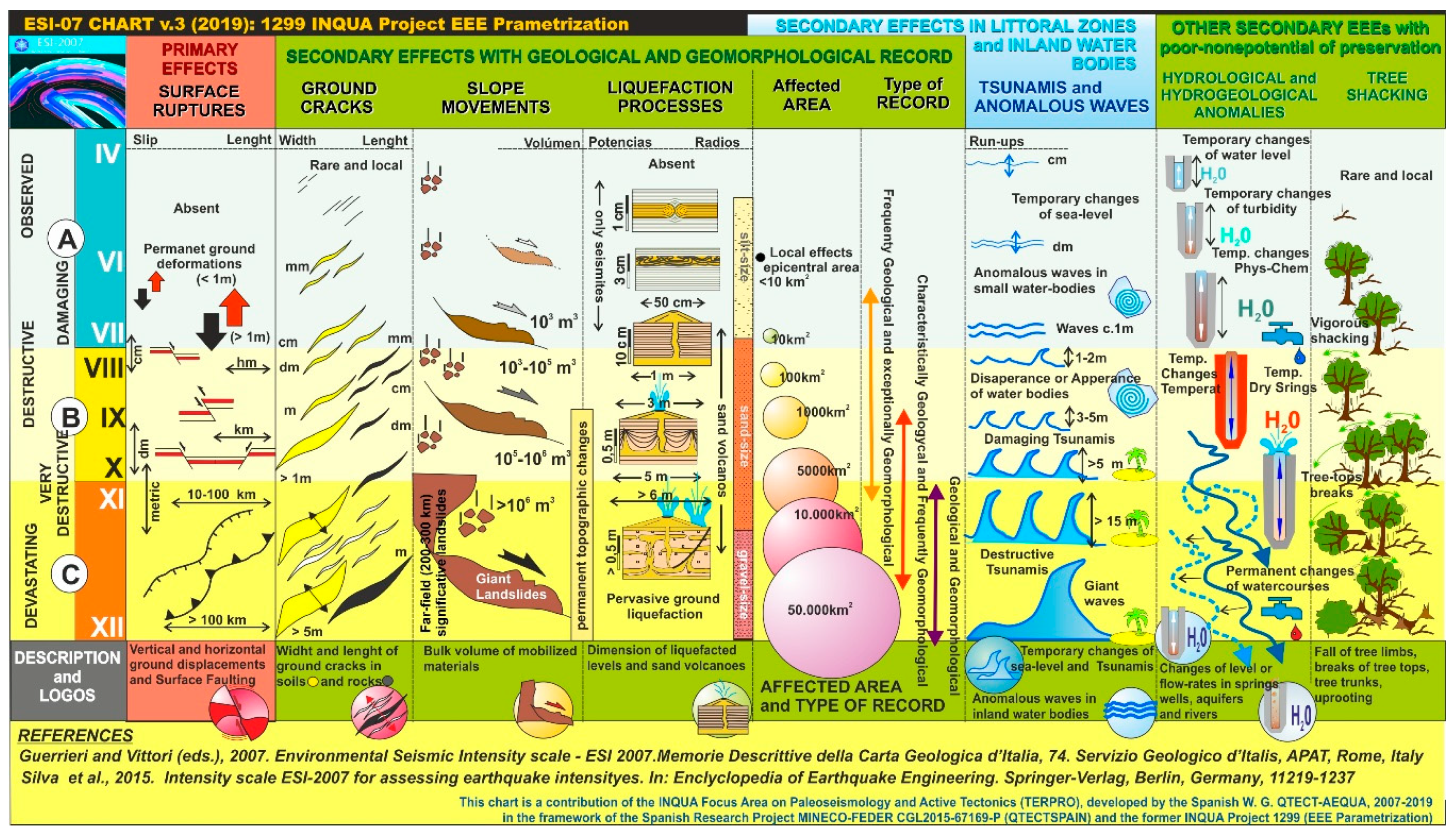
:1. Introduction to the Environmental Seismic Intensity Scale ESI-07
- To complete historical records of earthquakes for a more fine-tuning of intensity assessments.
- To link historical EEE records with paleoseismological data in the zone/fault of interest.
- To include paleoseismological and geological earthquake records in seismic hazard assessments (SHA).
- To assess intensities in modern earthquakes both in urban and no-urban areas where EEEs occurred and participated in the recorded damage. This point is critical for the future refinement of the scale.
2. The Content of the Catalogue
3. Type of Catalogued Earthquakes
- (a)
- Instrumental Earthquakes (Code: INS) occurred since AD 1963 to the present and recorded by the National Seismic Network of the “Instituto Geográfico Nacional” (IGN). These types of events have the more precise instrumental records, mainly from 1988 CE [21], complemented with quality macroseismic information. In some cases, there are specific field reports produced by official institutions (i.e., IGN, IGME and IAG) or Civil Protection for those that occurred from 1995 CE. Five events of this type have been catalogued, one of them with complete information (Table 1) which corresponds to the Lorca 2011 CE earthquake—the only one with a specific geological field report produced by the Geological Survey of Spain [22].
- (b)
- Pre-Instrumental Earthquakes (Code: PRE) occurred between the years AD 1900 and 1962. This is a special period in Spain between the installation of the first mechanical seismographs and the implementation of the National Seismic Network (“Red Sísmica Nacional”) [21]. These types of events have macroseismic information of different quality from old seismic records and field reports. In general, most of this type of events are the worst documented ones from the point of view of the geological effects. The catalogue includes seven (7) events of this type, two of them with complete macroseismic information (Table 1).
- (c)
- Historical Earthquakes (Code: HST) are documented by written historical sources from the year 800 BCE to 1900 CE. For this type of events the information is of macroseismic character but strongly supported by the analysis of the geological effects (EEEs) reported in historic documents and newly studied archaeoseismological data (EAEs), especially for those occurred after the 1755 CE Lisbon Earthquake-Tsunami for which field earthquake reports are common. Forty-one events of this type have been catalogued, nine of them with complete macroseismic information (Table 2).
- (d)
- Ancient Earthquakes (Code: ARQ). Mainly documented by archaeological and geoarchaeological data (EAEs) and supported by a variety of geological data (EEEs), but still not included in the conventional EMS catalogues [7] or in the updated on-line databases of the National Seismic Network [23]. As aforementioned, within this category the more ancient ones are the Neolithic event documented in “La Cueva del Toro” in Antequera (Málaga) and the Bronze Age event of “La Tira del Lienzo” (Murcia) located just above the trace of the Lorca-Alhama de Murcia fault. However, the more significant events included in this category are those that occurred during the Roman Period in Spain documented in the archaeological sites of “Baelo Claudia” [24] in Tarifa (Cádiz) and “Complutum” [25] in Alcalá de Henares, 25 km south of the city of Madrid. There are five (5) events catalogued for this category, three of them with complete macroseismic information (Table 2).
- (e)
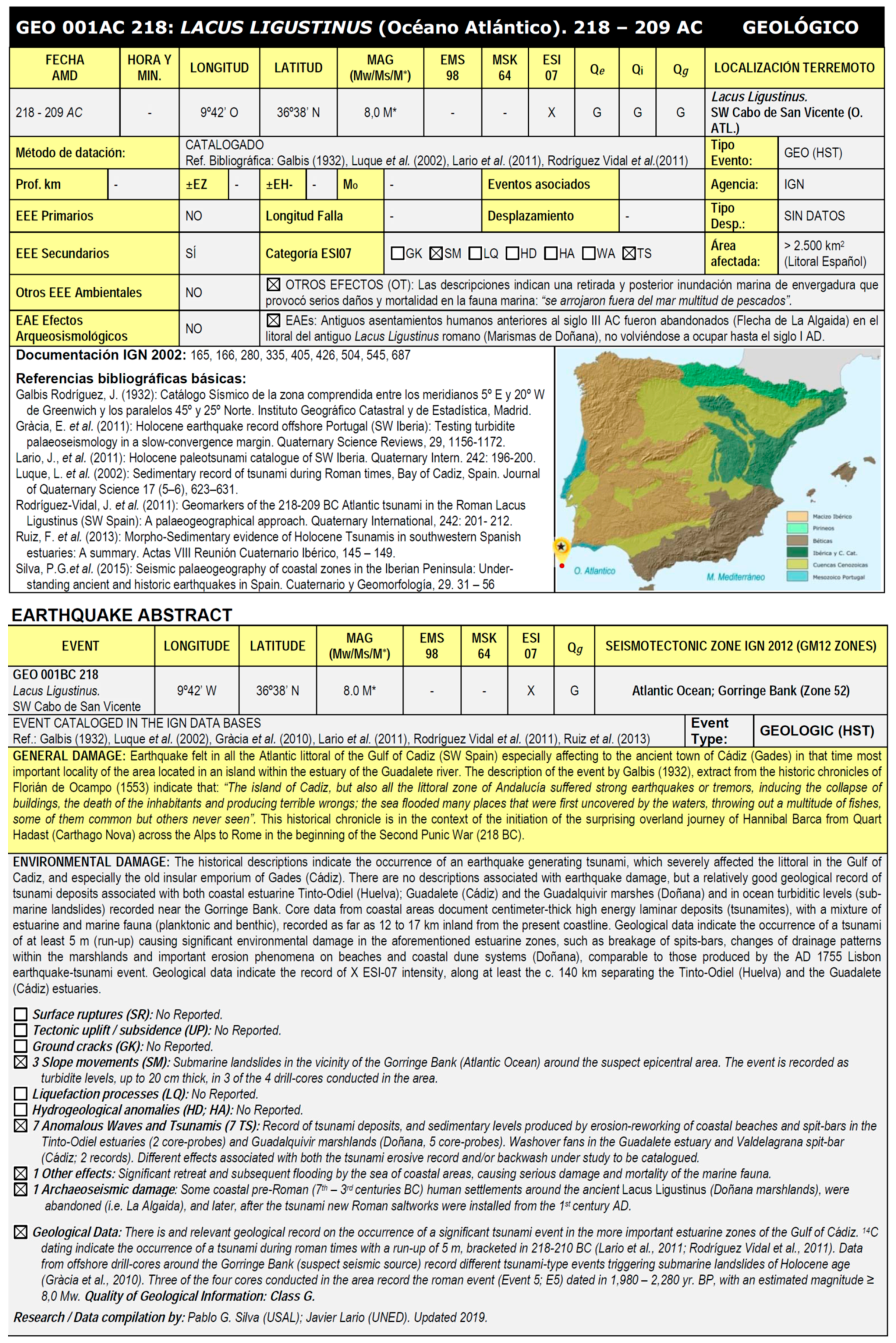
- Paleoearthquakes or paleoseismic events (Code: GEO) with only geological record, albeit in some cases supported by limited geoarchaeological data. This type of event covers from the most ancient historical periods in Spain (c. 10th century CE) to the onset of the Holocene epoch (c. 11.2 ka BP) and they are not included in the conventional seismic catalogues as commonly occurs with the ancient earthquakes. These events are documented in scientific papers published during the 21st century, and they correspond to fault-trenching analyses (primary surface ruptures) or EEEs analysis (primary and secondary effects). Those related to fault-trenching studies correspond to surface-faulting events (≥7.0 Mw) that occurred during the late Holocene. However, there are fault-trenching data for some ancient earthquakes such as the Tobarra (Albacete) that occurred around the 500 CE [26] or Historical events such as the Arenas del Rey (Granada) that occurred in 1884 CE [27]. Another case of paleoearthquake largely documented by secondary EEEs is the 218 BCE Lacus Ligustinus event recorded in the present “Doñana Marshlands” (an ancient lake by that time) at the Guadalquivir river outlet in the Gulf of Cádiz (Atlantic Ocean) [28]. These authors identify an earthquake-tsunami event similar to the 1755 CE Lisbon event flooding the ancient roman embayment and breaking the existing littoral spit-bars. Other authors document this event in turbidite layers obtained in deep sea cores in the Atlantic ocean near the Gorringe Bank [29] or in other marshlands of the Gulf of Cádiz, such as the Odiel and Tinto river mouths at Huelva or the Guadalete river mouth near Cádiz [30,31]. It is to note that the Lacus Ligustinus event is the unique geological event with historical written records describing the destruction of Cádiz just before the march of Hannibal to Rome across the Alps in the beginning of the Second Punic War in 218 BCE [32]. All these paleoseismic events are supported by a significant number of geochronologic data (14C, OSL and TL data), as is also the case for most of the ancient earthquakes further documented by archaeological data.
4. Type of Information for the Catalogued Earthquakes.
5. Quality of the Seismic and Geological Information for the Catalogued Earthquakes
5.1. Quality of Source Location Determinations (Qe)
- Quality A (location error <10 km): macroseismic epicenter surrounded by several macroseismic data-points, whose density allows estimating the source location with an uncertainty ± 5 km. This category, of course includes those earthquakes instrumentally recorded after the year 1963 CE (labelled as Quality I).
- Quality B (location error <20 km): macroseismic epicenter defined by a small number of macroseismic data-points, which density allows estimating the source location with an uncertainty ± 10 km. The epicentral determinations for some of the earthquakes recorded between 1900 and 1963 CE (Spanish pre-instrumental period) are very imprecise and most of the events occurred in that period hold B quality (some even C).
- Quality C (location error 20–50 km): macroseismic epicenter located in a continental area defined by a single macroseismic data-point or by a few ones very distant each other. These can present an uncertainty above ± 25 km, normally within a radius of 50 km.
- Quality D (location error >50 km): macroseismic epicenter located in a coastal locality as the unique macroseismic data-point, or those that occurred offshore which can be poorly defined assuming location uncertainties above ± 25 km. This quality-class also includes very ancient historical earthquakes recorded by vague and generic written descriptions refereed to very broad regions, such as Gulf of Cádiz, Atlantic Ocean, Mediterranean coast and the Pyrenees. This is the general case for most of the catalogued historical earthquakes before the 10th century BCE around the Iberian Peninsula.
- Quality Q (location error <20 km): Events not recorded by written sources with an only point, or very few points with archaeoseismic and/or paleoseismic information. This quality-class includes those earthquakes with limited archaeoseismic information indicating ground shaking (building fabric EAEs) or occasional paleoseismic information related to secondary earthquake environmental effects (EEEs), avoiding the identification of any reliable epicenter. In these cases, the provided geographical coordinates correspond to the more relevant archaeoseismic or paleoseismic data-points related to the catalogued event. In most cases, these correspond to near-field effects occurring to epicentral distances down to 20 km, and by the acquired experience, the uncertainty would be even down to ±5 km considered for the “Quality A” events.
- Quality G (location error <10 km): The available information is only of geologic nature, providing the geographical coordinates to the investigated points with paleoseismic information regarding primary EEEs of the ESI-07 scale, such as surface ruptures, fault scarps or fault-trenching analysis defining the seismic source. Consequently, this quality-class may hold more accurate locations than the “Quality A” events. In the case of the record of an important number of secondary EEEs the provided geographical coordinates are those corresponding to the zones where EEEs display largest dimensions, frequency or number (consequently intensity). These zones generally define areas no larger than a few squared kilometers wide, where the true macroseismic epicenters are located. This is not valid for strong offshore events or zones with an important proved susceptibility to ground shaking amplification.
5.2. Quality of Earthquake Intensity Assessments (Qi)
- Quality A: Density of points with macroseismic information is sufficient to undertake reliable intensity assessment. Normally, this class includes those earthquakes with more than 30 data-points, which generally refers to events that occurred after the 17th century CE.
- Quality C: The available points with macroseismic information are insufficient to undertake reliable intensity assessments. In some cases, there is a single data-point. These earthquakes include old events historically documented, but with little to no geological information, normally occurring before the year 1000 CE.
- Quality B: The accuracy of the intensity assessments is between the two previously mentioned quality classes. This is normally the case of those events that occurred between the 10th and 17th centuries CE. However, for some of them, macroseismic data-points are up to 15–20, including a variety of geological information on secondary EEEs.
- Quality D: EEEs ambiguously or roughly described in historical documents in reference to a region instead to particular localities, which lack modern geological studies. This is normally the case of all the catalogued events for the first millennia of the present era, but also most of the earthquakes that occurred before the present common era, with poor to no geological evidence. Descriptions such as “mountains and plains opened; the earth guzzled and engorged villages and hills; the sea shrank away, islands and islets disappeared; many villages in the southern and western coasts of Spain were totally ruined”, characterize this type of events. This corresponds to the translation of original Arabic text for the 881CE earthquake affecting the old Al-Andalus in South Spain.
- Quality G: EEEs related to historical or prehistoric events, normally not included in the conventional seismic catalogues. They are only documented by geological information coming from recent scientific paleoseismic and archaeoseismic published papers. In general, this quality class includes earthquakes that occurred during the first millennia of the present common era, particularly those that occurred during the Roman and Visigoth period in Spain, but also those only geologically documented.
- Quality I: EEEs linked to recent earthquakes that occurred during the 20th century and the onset of the 21st century. These events are instrumentally recorded and geological effects have been documented “in situ” after the earthquake by scientific commissions or groups of earthquake geologists interested in the event. This quality class normally has the best Qe, Qi and Qg quality indexes. However, as aforementioned some of the pre-instrumental period events (1900–1962 CE) have a poor Qg index with poorly defined descriptions of geological effects, similar to those of Quality B.
5.3. Quality of the Geological Information (Qg)
- Quality A: EEEs widely documented by technical or field reports, scientific papers and journals of the earthquake epoch that have undergone modern geological research published in scientific papers, allowing the quantification of primary and or secondary effects. Generally, this class includes those events that occurred after 1800 CE (19th century), although some 18th century events were also well documented in this time (i.e., 1755 CE Lisbon Earthquake).
- Quality B: EEEs vaguely described in historical documents, but subject of modern published geological research. These events mainly correspond to those that occurred between the 15th and 19th centuries and most of those that occurred during the so-called “pre-instrumental period” in Spain (1900–1962 CE). These normally have good Qe and Qi indexes, but poor geological information, since the progressive implementation of seismographs in Spain during the first half of the 20th century resulted in increasingly worse field-reports.
- Quality C: EEEs ambiguously or roughly described in historical documents in reference to a region instead to particular localities, which lack modern geological studies. This is normally the case of all the catalogued events for the first millennia of the present Common Era, but also most of the earthquakes that occurred before the present Common Era, with poor to no geological evidence, with historical descriptions similar to that transcribed for the Quality C events of the Qi index.
- Quality G: EEEs related to historical or prehistoric events, normally not included in the conventional seismic catalogues. They are only documented by geological information coming from recent scientific paleoseismic and archaeoseismic published papers. In general, this quality class includes earthquakes that occurred during the first millennia of the present common era, particularly those that occurred during the Roman and Visigoth period in Spain, such as those recorded in Baelo Claudia [44], but also those only geologically documented.
- Quality I: EEEs linked to earthquakes that occurred during the 20th century and the onset of the 21st century. These events are instrumentally recorded and geological effects have been documented “in situ” after the earthquake by scientific commissions or groups of earthquake geologists interested in the event. This quality class commonly holds the best Qe, Qi and Qg quality indexes. However, as aforementioned some of the events of the pre-instrumental period (1900–1962 CE) have a poor Qg index with poorly defined descriptions of geological effects, similar to those of Quality B events.
5.4. Overall Quality for Earthquake Information
6. Event Files: Summarized Information for the 51 Catalogued Earthquakes
7. Full Event and EEE Files: Full Information for Selected Catalogued Earthquakes
7.1. EEE Files: Detailed Information for Each Catalogued Event
7.2. Graphic Information Included in the “Full Event Files”
7.3. Summary on the Structure and Content of the “Full Event Files”
- Event file (51 earthquakes): These files contain parametric data, earthquake type, quality indexes, summarized information on building (EMS-based) and environmental damage (ESI-based), a list of identified EEEs for the different categories of ESI-07 effects, and archaeoseismic damage (EAEs). Additionally, these files display summarized information on the geological data supporting the earthquake, a geological sketch of the Iberian Peninsula for location (Figure 2), five to six key references documenting the earthquake and a list of the authors compiling the information. Fifty one-page files in Spanish and English (Figure 5).
- Earthquake description in the Galbis Catalogue (16 selected Earthquakes): Transcription of original descriptions and references in these initial seismic catalogues. For those events not listed in the Galbis catalogue this section is substituted by a “general information” section including data from field, technical, scientific reports and scientific publications available for those earthquakes. Sixteen one-page sections.
- Earthquake environmental effects (16 selected earthquakes): Analysis and discussion of the catalogued EEEs in the format of a two-page short paper.
- Earthquake archaeological effects (16 selected earthquakes): Analysis and discussion of the catalogued EAEs in the format of a two-page short paper. In modern earthquakes, the analysis of EAEs is focused on its impact on the cultural heritage of the affected area. As in the previous case, this section has also a two-page format.
- Parametric list of the particular EEEs and EAEs (16 selected earthquakes), identified for each earthquake. For those cases with a great number of effects (above 50) the number of published EEEs/EAEs files was normalized to about 50 representative files (Figure 7).
- EEE and EAE files (totaling 322) for the 16 selected earthquakes, with detailed information in the geological and geomorphological context, ground conditions, as well as descriptions, interpretation and quantification of the particular EEE or EAE catalogued effect.
- Google Earth image (16 selected earthquakes) representative of the distribution of EEEs and EAEs coming from the kmz files produced for the catalogue which will be implemented in the near future in an online public database of the Geological Survey of Spain (Figure 8).
- ESI-07/EMS-98 hybrid intensity maps (16 selected earthquakes) on shaded relief models, specifically designed for the published catalogue. In the case of earthquakes with few intensity data, like ancient or paleoseismic events, the intensity map is substituted by damage maps/sketches or by the log of the fault-trench documenting the event (Figure 9).
- Seismic Scenarios or ShakeMaps (16 selected earthquakes) in terms of PGA values, based on those developed by the USGS ShakeMap Program but specifically adapted for the Iberian Peninsula (Figure 10).
- Reference list (16 selected earthquakes): Complete bibliographic list with the old historic documents and modern research papers documenting or analyzing the catalogued earthquake.
7.4. Special “Full Event File” for the AD 1755 Lisbon Earthquake-Tsunami Event
8. Brief Numerical Analysis of the Catalogued EEEs
9. Achievements and Future Perspectives
Author Contributions
Funding
Acknowledgments
Conflicts of Interest
References
- Serva, L.; Vittori, E.; Comerci, V.; Esposito, E.; Guerrieri, L.; Michetti, A.M.; Mohammadioun, B.; Mohammadioun, G.C.; Porfido, S.; Tatevossian, R. Earthquake Hazard and the Environmental Seismic Intensity (ESI) Scale. Pure App. Geophys. 2016, 173, 1479–1555. [Google Scholar] [CrossRef]
- Serva, L. History of the Environmental Seismic Intensity Scale ESI-07. Geosciences 2019, 9, 210. [Google Scholar] [CrossRef]
- Michetti, A.M.; Esposito, E.; Guerrieri, L.; Porfido, S.; Serva, L.; Tatevossian, R.; Vittori, E.; Audemard, F.; Azuma, T.; Clague, J.; et al. Intensity Scale ESI 2007; ISPRA: Roma, Italy, 2007; Volume 74, ISBN 9788824029032. [Google Scholar]
- Grünthal, G. European Macroseismic Scale 1998: EMS98; Musée Natioal d´Historie Narurelle: Luxembourg, 1988; p. 99. [Google Scholar]
- Silva, P.G.; Guerrieri, L.; Michetti, A.M. Intensity scale ESI 2007 for assessing earthquake intensities. In Encyclopedia of Earthquake Engineering; Beer, M., Kougioumtzoglou, I.A., Patelli, E., Au, S.K., Eds.; Springer: Berlin/Heidelberg, Germany, 2015; ISBN 978-3-642-35344-4. [Google Scholar]
- IAEA. Seismic Hazards in Site Evaluation for Nuclear Installations; IAEA Safety Standards Series No. SSG-9; International Atomic Energy Agency: Vienna, Austria, 2010; p. 193. [Google Scholar]
- Martínez Solares, J.M.; Mezcua, J. Catálogo Sísmico de la Península Ibérica (880 a.C.–1900); Instituto Geográfico Nacional: Madrid, Spain, 2002; p. 253. (In Spanish) [Google Scholar]
- Udías, A. Historical Earthquakes (before 1755) of the Iberian Peninsula in Early Catalogs. Seism. Res. Let. 2015, 86, 999–1003. [Google Scholar] [CrossRef]
- Silva, P.G.; Rodríguez-Pascua, M.A.; Giner-Robles, J.L.; Pérez-López, R.; Lario, J.; Perucha, M.A.; Bardají, T.; Huerta, P.; Roquero, E.; Bautista Davila, M.B. Catálogo de los Efectos Geológicos de los Terremotos de España, 1ª Ed; Riesgos Geológicos y Geotecnia 4. IGME: Madrid, Spain, 2014; p. 352. (In Spanish) [Google Scholar]
- Silva, P.G.; Rodríguez-Pascua, M.A.; Giner-Robles, J.L.; Pérez-López, R.E.; García-Tortosa, F.J.; Gómez Vicente, P.; Bardají, T.; Perucha, M.A.; Huerta, P.; Lario, J.J.; et al. Catálogo de los Efectos Geológicos de los Terremotos de España, 2ª Ed. Revisada y Ampliada; Riesgos Geológicos y Geotecnia 6. IGME: Madrid, Spain, 2019; p. 804. (In Spanish) [Google Scholar]
- IGN. Actualización de Mapas de Peligrosidad Sísmica en España 2012; Instituto Geográfico Nacional (IGN): Madrid, Spain, 2013; p. 228. (In Spanish) [Google Scholar]
- Silva, P.G.; Rodríguez-Pascua, M.A.; Pérez-López, R.; Bardají, T.; Lario, J.; Alfaro, P.; Martínez-Díaz, J.J.; Reicherter, K.; Giménez García, J.; Giner, J. Catalogación de los efectos geológicos y ambientales de los terremotos en España en la Escala ESI 2007 y su aplicación a los estudios paleosismológicos. Geotemas 2008, 6, 1063–1066. (In Spanish) [Google Scholar]
- Rodríguez-Pascua, M.A.; Pérez-López, R.; Silva, P.G.; Giner-Robles, J.L.; Garduño-Monroy, V.H.; Reicherter, K. A Comprehensive Classification of Earthquake Archaeological Effects (EAE) for Archaeoseismology. Quat. Int. 2011, 242, 20–30. [Google Scholar]
- Bradley, R.; García Sanjuán, L. Sudden time? Natural disasters as a stimulus to monument building, from Silbury Hill (Great Britain) to Antequera (Spain). In The Neolithic of Europe; Bickle, P., Cummings, V., Hoffman, D., Pollard, J., Eds.; Oxbow Books: Oxford, UK, 2017; pp. 188–200. [Google Scholar]
- Ferrater, M.; Silva, P.G.; Ortuño, M.; Rodríguez-Pascua, M.A.; Masana, E. Archaeoseismologic analysis of a Late Bronze Age site on the Alhama de Murcia Fault: Tira del Lienzo (Murcia, SE Spain). Geoarchaeology 2015, 30, 151–165. [Google Scholar] [CrossRef]
- Silva, P.G.; Pérez-López, R.; Rodríguez-Pascua, M.A.; Roquero, E.; Giner Robles, J.L.; Huerta, P.; Martínez-Graña, A.; Bardají, T. Macroseismic analysis of slope movements triggered by the 2011 lorca earthquake (Mw 5.1): Application of the ESI-07 scale. Geogaceta 2015, 57, 35–38. [Google Scholar]
- Silva, P.G.; Elez, J.; Giner-Robles, J.L.; Gómez-Diego, P.V.; Rodríguez-Pascua, M.A.; Roquero, E.; Martínez-Graña, A.; Bardají, T. The AD 1755 Lisbon Earthquake-Tsunami: Modeling the seismic source from the analysis of environmental and building macroseismic data. GNS Sci. Misc. Ser. 2017, 110, 358–361. [Google Scholar]
- Duarte, J.C.; Rosas, F.M.; Terrinha, P.; Schellart, W.P.; Boutelier, D.; Gutscher, M.-A.; Ribeiro, A. Are subduction zones invading the Atlantic? Evidence from the southwest Iberia margin. Geology 2013, 41, 839–842. [Google Scholar] [CrossRef]
- Silva, P.G.; Elez, J.; Giner-Robles, J.L.; Rodríguez-Pascua, M.A.; Pérez-López, R.; Roquero, E.; Bardají, T.; Martínez-Graña, A.M. ESI-07 ShakeMaps for instrumental and historical events in the Betic Cordillera (SE Spain): An approach based on geological data and applied to seismic hazard. Quat. Int. 2017, 451, 185–208. [Google Scholar] [CrossRef]
- Pérez-López, R.; Elez, J.; Silva, P.G.; Giner-Robles, J.L.; Rodríguez-Pascua, M.A.; Roquero, E.; Bardají, T. Utilización de shakemaps y efectos geológicos como escenarios para simulacros en gestión de desastres. In Proceedings of the 3ª Reunión Ibérica sobre Fallas Activas y Paleosismología IBERFAULT III, Alicante, Spain, 11–15 June 2018. (In Spanish). [Google Scholar]
- Martínez Solares, J.M. Sismicidad pre-instrumental: Los grandes terremotos históricos en España. Enseñ. Cienc. Tierra 2011, 19, 296–304. (In Spanish) [Google Scholar]
- IGME. Informe Geológico Preliminar del Terremoto de Lorca del 11 de Mayo de 2011 (Mw 5,1); Instituto Geológico y Minero de España (IGME): Madrid, España, 2011; p. 47. (In Spanish) [Google Scholar]
- IGN. Official web page of the Spanish Seismic Network; Red Sísmica Nacional. Instituto Geográfico Nacional (IGN): Madrid, España. Available online: http://www.ign.es/web/ign/portal/sis-catalogo-terremotos (accessed on 26 July 2019). (In Spanish).
- Silva, P.G.; Borja, F.; Zazo, C.; Goy, J.L.; Bardají, T.; De Luque, L.; Lario, J.; Dabrio, C.J. Archaeoseismic record at the ancient Roman City of Baelo Claudia (Cádiz, South Spain). Tectonophysics 2005, 408, 129–146. [Google Scholar] [CrossRef]
- Rodríguez-Pascua, M.A.; Silva, P.G.; Perucha, M.A.; Giner-Robles, J.L.; Heras, C.; Bastida, A.B.; Carrasco García, P.; Roquero, E.; Bardají, T.; Lario, J.; et al. Seismically induced liquefaction structures in La Magdalena archaeological site, the 4th century AD Roman Complutum (Madrid, Spain). Sediment. Geol. 2016, 344, 34–46. [Google Scholar] [CrossRef]
- Rodríguez-Pascua, M.A.; Silva, P.G.; Garduño-Monroy, V.H.; Pérez-López, R.; Israde-Alcántara, I.; Giner-Robles, J.L.; Bischoff, J.; Calvo, J.P. Ancient earthquakes from archaeoseismic evidence during the Visigothic and Islamic periods in the archaeological site of “Tolmo de Minateda” (SE of Spain). In Special Paper of the Geological Society of America; Sintubin, M., Stewart, I., Niemi, T., Altunel, E., Eds.; Geological Society of America: Boulder, CO, USA, 2010; Volume 471, pp. 171–184. [Google Scholar]
- Grützner, C.; Ruano, P.; Jabaloy, A.; Galindo-Zaldívar, J.; Becker-Heidmann, P.; Sanz de Galdeano, C.; Rudersdorf, A.; Reicherter, K. Late Holocene rupture history of the Ventas de Zafarraya Fault (Southern Spain). Cuatern. Geomorfol. 2013, 27, 51–61. [Google Scholar]
- Rodríguez-Vidal, J.; Ruiz, F.; Cáceres, L.M.; Abad, M.; González-Regalado, M.L.; Pozo, M.; Carretero, M.I.; Monge-Soares, A.M.; Gómez-Toscano, F. Geomarkers of the 218-209 BC Atlantic tsunami in the Roman Lacus Ligustinus (SW Spain): A palaeogeographical approach. Quat. Int. 2011, 242, 201–212. [Google Scholar] [CrossRef]
- Gràcia, E.; Vizcaino, A.; Escutia, C.; Asioli, A.; Rodés, A.; Pallás, R.; García-Orellana, J.; Lebreiro, S.; Goldfinger, C. Holocene earthquake record offshore Portugal (SW Iberia): Testing turbidite palaeoseismology in a slow-convergence margin. Quat. Sci. Rev. 2010, 29, 1156–1172. [Google Scholar] [CrossRef]
- Lario, J.; Zazo, C.; Goy, J.L.; Silva, P.G.; Bardají, T.; Cabero, A.; Dabrio, C.J. Holocene palaeotsunami catalogue of SW Iberia. Quat. Int. 2011, 242, 196–200. [Google Scholar] [CrossRef] [Green Version]
- Silva, P.G.; Bardají, T.; Roquero, E.; Martínez-Graña, A.; Perucha, M.A.; Lario, J.; Giner Robles, J.L.; Rodríguez-Pascua, M.A.; Pérez-López, R.; Cabero, A.; et al. Seismic palaeogeography of coastal zones in the Iberian Peninsula: Understanding ancient and historic earthquakes in Spain. Cuatern. Geomorfol. 2015, 29, 31–56. [Google Scholar]
- Gómez, F.; Arruda, A.M.; Rodríguez-Vidal, J.; Cáceres, L.M.; Ruiz, F. Eventos marinos de alta energía y cambios traumáticos en los asentamientos costeros del Suroeste de la Península Ibérica. Cuatern. Geomorfol. 2015, 29, 57–74. (In Spanish) [Google Scholar] [CrossRef]
- Ambraseys, N. Earthquakes in the Eastern Mediterranean and the Middle East: A Multidisciplinary Study of Seismicity up to 1900; Cambridge University Press: New York, NY, USA, 2009; p. 901. [Google Scholar]
- Rodríguez-Pascua, M.A.; Silva, P.G.; Giner-Robles, J.L.; Pérez López, R.; Perucha, M.A.; Martín-González, F. Arqueosismología: una nueva herramienta para la sismología y la protección del patrimonio. Rev. Otarq 2016, 1, 151–169. (In Spanish) [Google Scholar] [CrossRef]
- Rodríguez-Pascua, M.A.; Giner-Robles, J.L.; Silva, P.G.; Pérez-López, R.; Perucha, M.A.; Elez, J.; Bardají, T.; Roquero, E.; Sánchez Ramos, I.; Morín de Pablos, J. The record of ancient and historic earthquakes in the archaeological site of Idanha a Vela (Central Portugal; Iberian Peninsula). GNS Sci. Misc. Ser. 2017, 110, 338–341. [Google Scholar]
- Giner-Robles, J.L.; Bardají, T.; Rodríguez-Pascua, M.A.; Silva, P.G.; Roquero, E.; Elez, J.; Perucha, M.A.; Baena, R.; Guerrero, I.; Fernández-Caro, J.J.; et al. Análisis arqueosismológico del conjunto arqueológico romano de Mulva- Munigua (Sevilla, España). Geotemas 2016, 16, 605–608. (In Spanish) [Google Scholar]
- Arteaga, C.; García Menárguez, A.; Prados Martínez, F.; Baudot, E. El Cabezo del Estaño de Guardamar (Alicante, España): Avance Preliminar de Evidencias Arqueosísmicas en un asentamiento Fenicio del Siglo VII a.C. Rev. Mundo Investig. 2016, 2, 146–155. (In Spanish) [Google Scholar]
- Giner-Robles, J.L.; Rodríguez-Pascua, M.A.; Silva, P.G.; Pérez-López, R. Efectos sísmicos en yacimientos arqueológicos: catalogación y cuantificación arqueosismológica. Bol. Geol. Min. 2018, 129, 445–463. (In Spanish) [Google Scholar] [CrossRef]
- Lario, J.; Bardají, T.; Silva, P.G.; Zazo, C.; Goy, J.L. Improving the coastal record of tsunamis in the ESI-07 Scale: Tsunami Environmental Effects Scale (TEE-16 scale). Geol. Acta. 2016, 14, 179–193. [Google Scholar]
- Rodríguez-Pascua, M.A.; Silva, P.G.; Giner-Robles, J.L.; Perucha, M.A.; Roquero, E.; Bardají, T.; Elez, J.; Pérez-López, R. Using earthquake archaeological effects for the identification of seismic damage and intensity assessments in the cultural heritage. In Scientific Management of Cultural Heritage; Pechioli, L., D’Amico, S., Venuti, V., Eds.; Springer Handbooks: Berlin, Germany, 2019; in press. [Google Scholar]
- Mezcua, J.; Rueda, J.; García Blanco, R.M. Iberian Peninsula Historical Seismicity Revisited: An Intensity Data Bank. Seism. Res. Let. 2013, 84, 9–18. [Google Scholar] [CrossRef]
- Mezcua, J.; Martínez Solares, J.M. Sismicidad del área Ibero-Mogrebí; Instituto Geográfico Nacional (IGN). Publicación 203: Madrid, Spain, 1985; p. 301. (In Spanish) [Google Scholar]
- Wells, D.L.; Coppersmith, K.J. New empirical relationships among magnitude, rupture length, rupture width, rupture area, and surface displacement. Bull. Seism. Soc. Am. 1994, 84, 974–1002. [Google Scholar]
- Silva, P.G.; Giner-Robles, J.L.; Reicherter, K.; Rodríguez-Pascua, M.A.; Grüztner, C.; García-Jiménez, I.; Carrasco, P.; Bardají, T.; Santos, G.; Roquero, E.; et al. Los terremotos antiguos del conjunto arqueológico romano de Baelo Claudia (Cádiz, Sur de España): Quince años de investigación arqueosismológica. Estud. Geol. 2016, 72, e050. [Google Scholar] [CrossRef]
- Galbis, J. Catálogo Sísmico de la zona Comprendida Entre los Meridianos 5º E y 20º W de Greenwich y los Paralelos 45º y 25º Norte; Instituto Geográfico Nacional: Madrid, Spain, 1932 & 1940; Volumes I and II. (In Spanish) [Google Scholar]
- NCSE-02. Real Decreto 997/2002, de 27 de septiembre. Boletín Oficial del Estado (BOE). Norma de la Construcción Sismorresistente Española 2002, 244, 35898–35967. (In Spanish) [Google Scholar]
- Wald, D.J.; Worden, B.C.; Quitoriano, V.; Pankow, K.L. ShakeMap Manual: Technical Manual, User’s Guide, and Software Guide; U.S. Geological Survey: Boulder, CO, USA, 2005; p. 132.
- IAEA. The Contribution of Paleoseismology to Seismic Hazard Assessment in Site Evaluation for Nuclear Installations, TEC-DOC 1767; International Atomic Energy Agency: Vienna, Austria, 2015; p. 206. [Google Scholar]
- Boore, D.M.; Joyner, W.; Fumal, T. Equations for estimating horizontal response spectra and peak acceleration from Western North American earthquakes: a Summary of recent Work. Seismol. Res. Lett. 1997, 68, 128–153. [Google Scholar] [CrossRef]
- Wald, D.J.; Allen, T.I. Topographic slope as a proxy for seismic site conditions and amplification. Bull. Seismol. Soc. Am. 2007, 97, 1379–1395. [Google Scholar] [CrossRef]
- Martínez Solares, J.M. Los Efectos en España del Terremoto de Lisboa; Monografías IGN, 19. IGN: Madrid, Spain, 2001; p. 756. (In Spanish) [Google Scholar]
- Hutton, C.; Shaw, G.; Pearson, R. Philosophical Transactions of the Royal Society of London 1750–1755; London: London, UK, 1809; Volume LXIX (69), pp. 646–656. [Google Scholar]
- Guerrieri, L. The EEE Catalogue: A global catalogue of Earthquake Environmental Effects. Quat. Int. 2012, 279, 179–180. [Google Scholar] [CrossRef]
- Audemard, F.; Azuma, T.; Baiocco, F.; Baize, S.; Blumetti, A.M.; Brustia, E.; Clague, J.; Comerci, V.; Esposito, E.; Guerrieri, L.; et al. Earthquake Environmental Effects for Seismic Hazard Assessment: The ESI Intensity Scale and the EEE Catalogue; ISPRA: Rome, Italy, 2015; Volume 97, ISBN 978-88-9311-007-5. [Google Scholar]
- Guidoboni, E.; Ferrari, G.; Tarabusi, G.; Sgattoni, G.; Comastri, A.; Mariotti, D.; Ciuccarelli, C.; Bianchi, M.G.; Valensise, G. CFTI5Med, the new release of the catalogue of strong earthquakes in Italy and in the Mediterranean area. Sci. Data 2019, 6, 1–15. [Google Scholar] [CrossRef]


| Year (CE) | Month & Day | Longitude | Latitude | Quality Qe Qi Qg | Magnitude | EMS-98 | ESI-07 | Location | Code Number |
|---|---|---|---|---|---|---|---|---|---|
| 1911 | Mar 21 | 1°15′ O | 38°01′ N | AIC | 5.7 Ms | VII-VIII | Torres de Cotilla. Murcia | 43. PRE 19110321 | |
| 1911 | Apr 03 | 1°12′ O | 38°06′ N | AIC | 5.3 Ms | VIII | VIII | Lorquí. Murcia | 44. PRE 19110403 |
| 1911 | May 31 | 3°42′ O | 37°12′ N | AIC | 4.9 Ms | VII-VIII | VIII | Santa Fe. Granada | 45. PRE 19119531 |
| 1917 | Jan 28 | 1°21′ O | 38°01′ N | AIC | VI-VII | Torres de Cotilla. Murcia | 46. PRE 19170128 | ||
| 1919 | Sep 10 | 0°50′ O | 38°05′ N | AIB | 5.2 Ms | VIII | VIII | Jacarilla. Alicante | 47. PRE 19191010 |
| 1930 | Jul 05 | 4°38′ O | 37°35′ N | AIB | 5.4 Ms | VII-VIII | Montilla. Cordoba | 48. Under study | |
| 1956 | Apr 19 | 3°41′ O | 37°11′ N | IIB | 5.0 Ms | VIII | VIII | Albolote. Granada | 49. PRE 19560419 |
| 1964 | Jun 09 | 2°34′ O | 37°44′ N | IIB | 4.8 mb | VIII | VIII | Galera. Granada | 50. PRE 19640609 |
| 1993 | Dec 23 | 2°55′ O | 36°46′ N | III | 5.0 Mw | VII | Adra. Almería | 51. Under study | |
| 1999 | Feb 2 | 1°50′ O | 38°10′ N | III | 4.8 Mw | VII | VII | Mula. Murcia | 52. INS 19990202 |
| 2002 | Aug 6 | 1°51′ O | 37°53′ N | III | 5.0 Mw | VI | VI | Bullas. Murcia | 53. INS 20020806 |
| 2003 | May 21 | 3°42′ O | 36°541′ N | III | 6.8 Mw | I | VI* | Mahón (tsunami*) Balearic Islandas | 54. INS 20030521 |
| 2005 | Jan 29 | 1°45′ O | 37°51′ N | III | 4.8 Mw | VII | VII | La Paca. Murcia | 55. INS 20050129 |
| 2011 | May 11 | 1°42′ O | 37°43′ N | III | 5.2 Mw | VII | VIII | Lorca. Murcia | 56. INS 20110511 |
| Year (CE) | Month & Day | Longitude | Latitude | Quality Qe Qi Qg | Magnitude | EMS-98 | ESI-07 | Location | Code Number |
|---|---|---|---|---|---|---|---|---|---|
| 4200–3700 BCE | 4°32′ O | 36°57′ N | CCG | ≥ 6.7 Mw | ≥ IX | Cueva del Toro. Antequera. Málaga | 1. APQ 004AC3700 | ||
| 1900–1550 BCE | 1°29′ O | 37°47′ N | GGG | 6.4 Mw | ≥ VIII | ≥ VIII | Tira del Lienzo. Totana, Murcia | 2. APQ 002AC1550 | |
| 800 BCE | 2°46′ E | 42°20′ N | CCC | ≥ VIII | Pirineos Orientales Alto Ampurdán. Gerona | 3. HST 001AC800 | |||
| 575–500 BCE | 2°46′ E | 42°20′ N | CCC | ≥ VIII | Pirineos Orientales Alto Ampurdán. Gerona | 4. HST 001AC 575 | |||
| 570–500 BCE | 10°00′ O | 36°28′ N | CCC | ≥ VIII | Andalucía, Mar Alborán. Mediterranean | 5. HST 001AC500 | |||
| 218–209 BCE | 9°42′ O | 36°38′ N | GGG | ≥ 8.0 Mw | ≥ IX | Lacus Ligustinus: SW Cabo San Vicente, Atlantic Ocean | 6. GEO 001AC218 | ||
| 040–060 CE | 5°46′ O | 36°05′ N | QQG | ≥ 5.5 Mw | ≥ VIII | ≥ VIII | Baelo Claudia. Bolonia. Cádiz | 7. ARQ 004060 | |
| 260–280 CE | 5°46′ O | 36°05′ N | QQG | ≥ 5.5 Mw | ≥ VIII | ≥ VIII | Baelo Claudia. Bolonia. Cádiz | 8. ARQ 0260280 | |
| 300–400 CE | 1°39′ O | 38°35′ N | GGG | 6.8 Mw | X | Illunum Tobarra. Albacete | 9. GEO 0300400 | ||
| 350–400 CE | 3°19′ O | 40°30′ N | QQG | ≥ 5.5 Mw | ≥ VIII | ≥ VIII | Complutum, Alcalá de Henares, Madrid | 10. ARQ 0350400 | |
| 881 CE | May 26 | 8°00′ O | 36°00′ N | DCC | 7.2 Mw | XI-X | XI | Golfo de Cádiz. Atlantic Ocean | 11. HST 08810000 |
| 949 CE | DCC | Zamora - Oporto. Atlantic Ocean | 12. HST 09490000 | ||||||
| 1048 CE | 0°55′ O | 38°05′ N | DCQ | VIII | VIII | Orihuela. Alicante | 13. HST 10480000 | ||
| 1169 CE | Jan 21 | 4°00′ O | 38°00′ N | DCQ | 6.0 Mw | VIII-IX | IX | Andújar. Jaén | 14. HST 11690121 |
| 1356 CE | Agu 24 | 10°00′ O | 36°30′ N | DCC | 6.5 Mw | VIII | SW. Cabo San Vicente. Atlantic Ocean | 15. HST 13560824 | |
| 1373 CE | Mar 02 | 0°45′ O | 42°30′ N | CCG | 6.2 Mw | VIII-IX | IX | Ribagorça, Lerida | 16. HST 13730302 |
| 1396 CE | Dec 18 | 0°13′ O | 39°05′ N | BBB | 6.5 Mw | VIII-IX | X | Tavernes de Valldigna. Valencia | 17. HST 13961218 |
| 1427 CE | May 15 | 2°30′ E | 42°12′ N | BBG | VIII-IX | IX-X | Olot. Gerona | 18. Under study | |
| 1428 CE | Feb 02 | 2°10′ E | 42°21′ N | BBG | IX-X | IX-X | Queralbs. Gerona | 19. Under study | |
| 1431 CE | Apr 24 | 3°38′ O | 37°08′ N | CBB | 6.7 Mw | VIII-IX | ≥ VIII | Sierra Elvira. Granada | 20. HST 14310424 |
| 1494 CE | Jan 26 | 4°20′ O | 36°35′ N | CBB | VIII | VIII | Málaga. Málaga | 21. HST 14940126 | |
| 1504 CE | Apr 05 | 5°28′ O | 37°23′ N | BAA | 6.8 Mw | VIII-IX | IX | Carmona. Sevilla | 22. HST 15040405 |
| 1518 CE | Nov 09 | 1°52′ O | 37°14′ N | BBA | VIII-IX | IX | Vera. Almaría | 23. HST 15181109 | |
| 1522 CE | Sep 22 | 2°40′ O | 36°58′ N | DBB | 6.5 Mw | VIII-IX | IX | W. Alhama de Almería. Almería | 24. HST 15220922 |
| 1531 CE | Sep 30 | 2°44′ O | 37°32′ N | CBB | VIII-IX | IX | Baza. Granada | 25. HST 15310930 | |
| 1620 CE | Dec 02 | 0°28′ O | 38°42′ N | CBB | VII-VIII | VIII | Alcoy. Alicante | 26. HST 16201202 | |
| 1656 CE | Jun 07 | 1°14′ O | 40°05′ N | BBB | VIII | VIII | Ademuz. Valencia | 27. HST 16560607 | |
| 1644 CE | Jun 19 | 0°25′ O | 38°48′ N | CBB | VIII | Muro de Alcoy. Alicante | 28. HST 16440619 | ||
| 1658 CE | Dec 31 | 2°28′ O | 36°50′ N | DBC | VIII | X | Almería. Almería | 29. HST 16581231 | |
| 1674 CE | Agu 28 | 1°42′ O | 37°41′ N | BBB | VIII | Lorca. Murcia | 30. HST 16740828 | ||
| 1680 CE | Oct 9 | 4°36′ O | 36°48′ N | BAB | 6.8 Mw | VIII-IX | IX | NW de Málaga. Málaga | 31. HST 16801009 |
| 1722 CE | Dec 27 | 7°46′ O | 36°24′ N | CBC | 6.5 Mw | VIII | Golfo de Cádiz. Atlantic Ocean | 32. Under study | |
| 1748 CE | Mar 23 | 0°38 O | 39°02′ N | AAA | 6.2 Mw | IX | IX | Estubeny. Valencia | 33. HST 17480323 |
| 1755 CE | Nov 01 | 10°00′ O | 36°30′ N | DAA | 8.5 Mw | XI-XII | XI | Lisbon Event: SW Cabo San Vicente. Atlantic Oc. | 34. HST 17551101 |
| 1804 CE | Jan 13 | 3°35′ O | 36°05′ N | CAB | 6.7 Mw | VII-VIII | VIII | Almería, Mar Alborán Mediterranean | 35. HST 18040113 |
| 1804 CE | Agu 25 | 2°50′ O | 36°46′ N | BAB | 6.4 Mw | VIII-IX | IX | Dalías. Almería | 36. HST 18040825 |
| 1806 CE | Oct 27 | 3°44′ O | 37°14′ N | ABB | 5.3 M | VIII | Pinos-Puente. Granada | 37. HST 18061027 | |
| 1829 CE | Mar 21 | 0°41′ O | 38°05′ N | AAA | 6.6–6.9 Mw | IX-X | X | Torrevieja. Alicante | 38. HST 18290321 |
| 1845 CE | Oct 07 | 0°45′ E | 41°02′ N | BBA | 5.1 Mw | VI-VII | VII | Tivissa. Tarragona | 39. HST 18451007 |
| 1851 CE | May 15 | 2°40′ E | 39°38′ N | BAA | ≥ 4.5 Mw | VII | VII | NE Palma de Mallorca. Balearic Islands | 40. HST 18510515 |
| 1863 CE | Jun 10 | 1°56′ O | 37°22′ N | AAA | 4.2–4.6 Mw | VI-VII | VIII | Huércal-Overa. Almería | 41. HST 18630610 |
| 1884 CE | Dec 25 | 3°59′ O | 37°00′ N | AAA | 6.5–6.7 Mw | IX-X | X | Arenas del Rey. Granda | 42. HST 18841225 |
© 2019 by the authors. Licensee MDPI, Basel, Switzerland. This article is an open access article distributed under the terms and conditions of the Creative Commons Attribution (CC BY) license (http://creativecommons.org/licenses/by/4.0/).
Share and Cite
Silva, P.G.; Rodríguez-Pascua, M.A.; Giner Robles, J.L.; Élez, J.; Pérez-López, R.; Davila, M.B.B. Catalogue of the Geological Effects of Earthquakes in Spain Based on the ESI-07 Macroseismic Scale: A New Database for Seismic Hazard Analysis. Geosciences 2019, 9, 334. https://doi.org/10.3390/geosciences9080334
Silva PG, Rodríguez-Pascua MA, Giner Robles JL, Élez J, Pérez-López R, Davila MBB. Catalogue of the Geological Effects of Earthquakes in Spain Based on the ESI-07 Macroseismic Scale: A New Database for Seismic Hazard Analysis. Geosciences. 2019; 9(8):334. https://doi.org/10.3390/geosciences9080334
Chicago/Turabian StyleSilva, Pablo G., Miguel A. Rodríguez-Pascua, Jorge L. Giner Robles, Javier Élez, Raúl Pérez-López, and M. Begoña Bautista Davila. 2019. "Catalogue of the Geological Effects of Earthquakes in Spain Based on the ESI-07 Macroseismic Scale: A New Database for Seismic Hazard Analysis" Geosciences 9, no. 8: 334. https://doi.org/10.3390/geosciences9080334