Article

A High-Precision Energy-Efficient GPS Time-Sync Method for High-Density Seismic Surveys

1
College of Instrumentation and Electrical Engineering, Jilin University, Changchun 130061, China
2
Key Laboratory of Geophysical Exploration Equipment, Ministry of Education, Jilin University, Changchun 130061, China
*
Author to whom correspondence should be addressed.
Appl. Sci. 2020, 10(11), 3768; https://doi.org/10.3390/app10113768
Submission received: 27 April 2020 / Revised: 20 May 2020 / Accepted: 25 May 2020 / Published: 29 May 2020
(This article belongs to the Section Electrical, Electronics and Communications Engineering)

Abstract

:
Large numbers of seismic channels and high-density energy-efficient acquisition systems are the development trend of seismic instruments and have attracted high R&D interests in recent years. The combination of remote sensing and wireless sensor network technology provides superior observation capabilities for high-density seismic exploration. However, large-scale and multi-node acquisition methods place higher requirements on time synchronization performance. Seismic data with poor time synchronization will cause considerable errors in the interpretation of seismic data and even have no practical significance. Thus, the strict time synchronization performance is the prerequisite and basis for the application of cable-less storage seismograph in high-density seismic array applications. The existing time synchronization methods have high power consumption and poor time synchronization accuracy, which is not suitable for the long-time task. In addition, these methods are affected by the number of nodes and the distance. This paper presents an energy-efficient time-sharing indexed interpolation intercept method for the seismic data synchronization. The time synchronization method uses the high-precision TCXO as the main clock and records GPS time in the SD card at intervals to achieve the high-precision time-stamp for the seismic data. Then the seismic data is intercepted intermittently based on precise time stamps, which achieves the strict seismic data synchronization. Performance analysis shows that the time synchronization accuracy of the proposed method is 0.6 μs and saves 73% energy of the time-sync periods compared to the common GPS timing method. The field measurement results indicate that the time synchronization accuracy is not associated with the working time and the distance between nodes so that the proposed synchronization method is suitable for the high-density seismic survey.

Graphical Abstract

1. Introduction

In order to meet the needs of more detailed geological structure surveys, the study of seismological methods relies on a denser seismological network, which is used to improve the resolution of seismological research and identify weak seismic phases [1]. Seismic exploration technology is increasingly developing in the direction of multi-channel, high-density, wide-azimuth, and high-efficiency acquisition [2]. The amount of seismic data has increased dramatically. Therefore, the demand for real-time processing of huge data streams at various acquisition sites has continued to increase. However, the cable seismograph has bulky cables and low fieldwork efficiency, which makes them inappropriate to use in difficult exploration environments. In contrast, the distributed nodal cable-less remote sensing seismograph is non-cable and portable, which makes it capable of adapting to complex exploration environments and the diversity of layout methods [3,4]. The distributed nodal seismic systems are divided into the wireless real-time seismic data acquisition systems and non-real-time storage type seismic data acquisition systems according to the data collection methods. The WTU-508 seismograph of Sercel Inc. and the RT3 seismograph of Wireless Seismic, Inc. are representatives of wireless real-time seismic acquisition systems [5,6,7]. These seismographs perform data acquisition and recovery in real-time, so the continuous wireless network support is needed. Wireless transmission of a large amount of seismic data requires a lot of energy, which also limits the application in high-density seismic array exploration. On the other hand, the non-real-time storage type systems perform long-term exploration work in the field and store the collected data in a local large-capacity storage device. After the survey is completed, a large amount of data would be downloaded to the server and aggregated into a database for data interpretation and processing [8]. So, the nodal cable-less storage type seismograph has the characteristics of no cable, large local storage capacity, and long working time capacity, which are highly efficient and suitable for the high-density seismic array exploration. The representatives of cable-less storage type seismograph are the GEIWSR of Jilin University, Quantum of INOVA Company, and Z-land of Fairfield Company [9,10,11]. Cable-less storage type seismograph performs distributed data acquisition and data recovery centrally, so it is crucial to distinguish what kind of seismic data is collected by each sensor node at a specific time in the process of seismic exploration. Therefore, the time base must be designed to ensure that the seismic data of the nodes can be time-stamped. The purpose of time synchronization in the whole seismic sensor network is to achieve a globally consistent logical clock so that all events and information in the entire system have a uniform time interpretation [12]. So it is essential to have an accurate and highly reliable time-synchronization performance between each sensor node. Currently, most distributed nodal cable-less storage type seismographs use GPS as a time-base to time-tag seismic data [13]. Figure 1 shows the schematic diagram for time synchronization in the high-density seismic array survey.
The sensor nodes are distributed in dozens of kilometers of mountainous terrain and other complex terrain exploration areas densely. The seismic source excites the seismic waves at multiple locations, and all the sensor nodes record the seismic data in real-time, which forms a dense seismic node observation system to realize the fine detection of underground geological structures. At the end of the acquisition task, all nodes carry out centralized seismic data downloading and then unified processing and interpretation are carried out on the large amount of seismic data. All sensor nodes need to be laid over a large area and have a long working period, so the sensor nodes need to be energy-efficient. Seismic data with poor synchronization capability will cause considerable errors in the interpretation of seismic data. When the acquisition time increases, the frequency drift of the crystal oscillator on the acquisition station will bring significant time-error accumulation. This requires that the time synchronization system must be able to perform error compensation or error correction. In addition, the synchronization error will increase as the number of nodes increases, and this is the most essential difference between distributed systems and other systems [14]. Thus, it places higher requirements on the time synchronization for large scale exploration task. It is urgent to develop a time tagging system for seismic data and a multi-node time-synchronous system for high-density seismic array survey.
The GEIWSR seismograph developed by Jilin University uses the high-precision GPS timing method, which has solved the problem of poor synchronization accuracy between distributed sensor nodes. Then they performed multiple field experiments that showed that the GEIWSR has an accurate time-synchronization ability [15]. However, the long-term operation of GPS equipment consumes a lot of energy. In addition, there is no GPS signal in the complex area (such as the jungle and other harsh environments), which brings great difficulties to the seismic exploration task. In 2013, the Fairfield Nodal Company launched the Z-land nodal seismograph, a small and cable-less portable storage type seismic acquisition system. It realizes time marking for seismic data with the built-in GPS receiver and the local clock system. Thus, the multi-node time-synchronization is ensured under the condition of low energy consumption [16]. However, the local clock of the instrument will drift and result in a large error when it works for a long time due to the change of working temperature, operating state, and so on. The clock accuracy of the Z-land system is only 100 μs by discontinuous GPS on–off with local clock, which is not very suitable for high-density seismic array surveys. The continuous working time of the Quantum nodal seismic exploration system developed by INOVA Company can reach 50 days in the field with the 24-h operation, but its time synchronization accuracy is about 40 μs [17]. Although it can meet the general field exploration requirements, it is still not very suitable for high-density seismic exploration applications. Some other equipment adopts a time synchronization scheme based on the Network Time Protocol (NTP). This scheme is suitable for time synchronization in small wireless sensor networks, and it is mainly based on the network transmission protocol. As the number of nodes and the exploration distance increase, the synchronization accuracy will also deteriorate. Therefore, a high-precision energy-efficient time-synchronization method that is not limited by the number of nodes and exploration distance is urgently needed.
In this paper, we present a high-precision energy-efficient time-synchronization method named the time-sharing indexed interpolation intercept (T3I) method, which combines GPS and high-precision TCXO for high-density seismic array surveys. In order to acquire a high-precision time-stamped system, we use the excellent frequency stability over temperature, low supply voltage, and a highly reliable crystal unit to achieve time stamping of the overall seismic data. An accurate time series between GPS pulse per second (PPS) interrupt and GPS serial interrupt is used to provide a reasonable time-service process. Further, the GPS synchronization time information is recorded in a large-capacity SD card. When the seismic data is collected by the control center, the seismic data with time stamp will be intercepted by segment time through the server. For energy-efficient design, it is put into sleep mode during the periods when no time service is provided. Therefore, the time-synchronization method can not only reduce the power consumption of the continuous use of GPS but also ensure the high-precision time service without the GPS signal. Even if the GPS signal is lost for several hours, the node can still acquire the seismic data with its high-precision TCXO continuously. After the node data is collected, the control center analyzes the clock shift of each node to ensure the time accuracy of the collected data automatically. In practical applications, this method has high time-service accuracy and energy efficiency. The remainder of this paper is organized as follows: Development of the energy-efficient GPS time-synchronization method is discussed in Section 2. The performance evaluation and results of system tests, including two field measurements, are presented in Section 3. The test results of the proposed time synchronization method and future research directions are discussed in Section 4. Finally, the conclusions of this work are discussed in Section 5.

2. Development of the GPS Time-Synchronization Method

2.1. Time-Synchronization Requirements for High-Density Seismic Array Survey

The accuracy of the time-synchronization is a design index proposed based on the seismic wave velocity and the exploration depth [18,19]. In order to investigate the impact of time accuracy on seismic surveys, a simplified model of a double-receiver seismic reflection survey is established, as shown in Figure 2. Seismic waves are excited by the source and vibrate the elastic medium. They are reflected through the stratigraphic interface and received by the receiver A and receiver B. Then, the travel time difference from the source to node A and node B can be expressed as follows:
Δ t = t 2 t 1 = 2 ( L 1 + L 2 ) 2 + H 2 v 2 L 1 2 + H 2 v  
where L 1 is half the distance from source O to the receiver A, L 2 represents that half the distance from source O to the receiver B minus L 1 , t 2 represents the travel time from the receiving point B to the source O, t 1 represents the travel time from the receiving point A to the source O, H represents the depth of stratigraphic reflection interface, and v represents the seismic wave speed. Assuming that H is 100 m, v is 4 km/s, L 1 is 50 m and L 2 is 2 m, and the travel time difference Δ t is 0.45 ms. The travel time difference between node A and node B is 0.45 ms with the given arrangement. In actual exploration work, the time accuracy should be less than 10% of the travel time difference, which is 45 μs, to ensure the accuracy of the seismic data interpretation.
It can also be seen that if the time-synchronization error is 1 ms, the estimated error of the stratigraphic interface of the seismic interpretation is about 4 m. Therefore, it is necessary to ensure that the time-synchronization accuracy is as high as possible to ensure strict data alignment and the quality of seismic data interpretation. The nodal cable-less storage-type seismic data acquisition system performs long-term, uninterrupted acquisition tasks under the condition of continuous source excitation, which requires the sensor nodes to be always kept synchronized. As the acquisition time increases, the frequency drift of the crystal oscillator on the acquisition station will bring significant time error accumulation [20,21]. The time-synchronization system should be able to continuously correct the time errors that occur to avoid error accumulation.

2.2. Description of the Cable-Less Storage Seismograph

The time synchronization platform designed in this paper is mainly for the new generation of nodal cable-less storage seismograph GEIWSR-III developed by Jilin University. The characteristics of the seismograph should be fully considered when designing time synchronization. The structural block diagram of GEIWSR-III is shown in Figure 3.
GEIWSR-III is mainly composed of a 5-Hz moving coil type geophone, a data recording unit, a power management unit, and a wireless monitoring unit. The geophone used in the GEIWSR-III is a moving coil velocity-type geophone with a natural frequency of 5 Hz. It has the sensitivity with 30 V/m/s and a wide, stable frequency band from 5 Hz to 200 Hz. In addition, it weighs only 80 g, which greatly improves the portability of the instrument. The data recording unit is the main time- synchronization platform, which includes the MCU, a data acquisition unit, a GPS positioning unit, an SD card storage unit, a wired Ethernet data download unit, and the status indication unit. In addition, the node also includes a power management module to provide a high-efficiency power supply for the entire system. The wireless monitoring unit equips a low-power ZigBee in each sensor node. It serves as a data quality monitoring system to provide status information of the node for users in a timely manner, which greatly improves exploration efficiency.
The time-synchronization system should complete the synchronization task among the nodes on the premise of not interfering with the normal acquisition work. The control center and each sensor node adopt the wireless multi-hop communication system to realize seismic data acquisition tasks. The time synchronization system is applied in the actual workflow of each node in the high-density seismic exploration environment. However, the actual working process of this system is more complicated. This article only discusses the links that are closely related to clock synchronization. The simplified system working flowchart is shown in Figure 4. After the system is powered on, the control center calls the station first and the wireless monitoring system of each sensor node responds to its own address number immediately. When a faulty node emerges, manually troubleshooting or repair is required. According to the survey line arrangement, the control center re-addresses each sensor node. After the sensor node receives its new address, it performs self-tests, and then sends the self-test parameter to the control center. When receiving the parameters of each node, the control center judges whether the node is normal. If normal, it configures the acquisition parameters for each node and starts the acquisition task. Otherwise, it will perform troubleshooting and repair manually. When the collection task is over, the control center sends the stop collection instruction and shutdown instruction. After receiving the instruction, each node executes the stop collection task and the shutdown process, and then the collection task ends. The acquisition process of GEIWSR-III can meet the basic exploration requirements, but the single acquisition time cannot be too long. Otherwise, the time deviation between the sensor nodes will continue to accumulate, which will cause the asynchronous data to affect the data processing and interpretation. Thus, the time-synchronization problem of the GEIWSR-III has greatly limited the efficiency of seismic exploration. If the time-synchronization can be performed, it can realize long-term continuous acquisition, even for dozens of days.

2.3. Time-Synchronization Method

It can be seen from Figure 4 that the time synchronization system should be established during the data acquisition task. Therefore, the data collection workflow and hardware architecture of the system should be analyzed in detail. Based on the GEIWSR-III hardware units and its workflow, we designed a multi-node time synchronization system based on GPS and crystal oscillator. The overall architecture of the time-synchronization system is shown in Figure 5. The MCU with UCOS-III operating system is responsible for maintaining and managing the normal operation of the system. High precision crystal oscillator provides time service and a standard time reference for ADC and DAC. When the system is turned on, it performs a self-test. The MCU controls the DAC to complete the short-circuit noise test, harmonic distortion test, and geophone impedance test. When the self-test is completed, the node starts to complete the acquisition of seismic data. When the data reaches the size of the data buffer, the MCU writes the seismic data to a file and then stores it in a large-capacity SD card in the form of a file block. Apparently, the seismic data file is also transmitted in the file format through the built-in FTP server in the MCU when the seismic data is acquired via the Ethernet.
Generally, GPS-disciplined ADC for high-precision time stamping is used to a data acquisition unit that synchronously samples multiple channels in a manner [22]. However, this method is usually applied to keep GPS turned on continuously. This method may not be applicable in long-term high-density seismic surveys. In this paper, a GPS file is used to record the exact time and the number of sampling points to time stamp the seismic data accurately. As shown in Figure 5, the seismic data file and the GPS time and data-point file are recorded in the data acquisition process at the same time. After the seismic data is collected, the server updates and marks the seismic data according to the GPS time and data-point file, and then performs multi-node seismic data files in the time-sharing interception, so as to achieve the purpose of time synchronization of multiple nodes.
The crystal oscillator provides counting reference for ADC during data acquisition. The data acquisition unit adopts a high-resolution 32-bit ADC named ADS1282. ADS1282 has a data-ready output pin DRDY, that is, MCU read the data on DRDY falling edge. We connect DRDY to the interrupt pin of the MCU. When the data is ready, the interrupt is generated, and then AD outputs the 32-bit data to MCU. The SYNC input pin and the SYNC command are the two sources for synchronization in the ADS1282. In actual application, we use the continuous-sync mode for synchronization with the SYNC command source. Figure 6 shows the timing for continuous-sync mode. In continuous-sync mode, there is a continuous clock (System Clock) applied to the SYNC pin with a frequency equal to the integer multiple of the output data rate.
When SYNC is applied, the device can run freely only if the period matches an integer multiple of the output data rate; otherwise, the device will resynchronize. Thus, the accuracy of AD conversion synchronization depends on the accuracy of the system clock. The system clock of ADC and DAC mainly rely on the crystal oscillator. Considering the energy-efficient design of the instrument, it is necessary to take the travel time accuracy and power consumption into consideration when selecting a crystal oscillator. The crystal oscillator is mainly divided into a voltage-controlled crystal oscillator (VCXO), a temperature-compensated crystal oscillator (TCXO), and an oven-controlled crystal oscillator (OCXO) [23]. The parameters are shown in Table 1.
As can be seen from Table 1, the main parameter items of various types of crystal oscillators are different. In the seismic survey, the frequency deviation is required to be as low as possible under the influence of temperature due to the complex environment. Of course, the start and stop operation of the instruments in the field needs a quick response of the crystal oscillator. In addition, the lower the power consumption of the crystal, the better the energy-efficient design. VCXO is a kind of crystal oscillator that can change the output frequency by adjusting the applied voltage. It is mainly used for phase-locked loop (PLL) or frequency trimming application [24]. However, its frequency shift is greatly affected by temperature; it is not suitable for the time service of this seismograph. The OCXO integrates a temperature control device. Thus, its power consumption is higher than that of VCXO and TCXO. Furthermore, the OCXO needs to be preheated. A large frequency offset will occur during the preheating process, which will cause a timing deviation. Therefore, we use the TCXO as the high-precision clock source for ADC and DAC. The working clock of ADC and DAC is 4.096 MHz. Due to the manufacturing process and other reasons, it is difficult to have a relatively low-frequency drift for a low-frequency crystal. In order to obtain a crystal with high reliability, low drift, and low power consumption, the XTAL OSC TCXO 16.3840 MHZ SNWV is selected as the time source. It has excellent frequency stability over temperature, low supply voltage, and highly reliable characteristics. In order to obtain an output of 4.096 MHz, we have designed a divide-by-four frequency divider for dividing the clock source. However, the signal output by the high-frequency crystal is a clipped sinewave. Thus, a circuit which performs clipped sinewave to CMOS signal is placed before the frequency divider.
In the acquisition task, the MCU places the data collected by the AD into the FIFO, and whenever the FIFO is stored to a certain capacity, the MCU reads the seismic data from the FIFO and stores it into the SD card in the form of data block files. After obtaining valid GPS information for the first time after the instrument is turned on, the GPS time information obtained at this time is used as a file name to establish the folder name and the file name for the seismic data. The folder name and the file name format are shown in Figure 7. We can see that the time corresponding to the first seismic data point is the UTC time given by the seismic data file name.
In this way, the first data of the first file is marked by the file name. The number of file blocks is increasing with the continuous collection of the sensor node. A new folder is created for data files only when one day has passed. Since the seismic data block size is set according to the specific data points, when collecting at a certain sampling rate, a data file index is established according to the folder directory and the file name. Thus, each seismic data point is time-stamped. For the synchronization of seismic data of multiple sensor nodes in a high-density seismic array, all the data can be aligned as long as searching the sampling point corresponding to the precise moment. However, due to the frequency tolerance of each crystal, frequency shift by temperature, and changes in different operating states, the crystal oscillator would have a frequency drift after a long period of operation. It has resulted in asynchrony between the multiple sensor nodes, which caused problems in data interpretation. The sensor node uses an active crystal oscillator whose frequency is 16.384 MHz ± 0.2 PPM. The maximum deviation Δ f m a x can be calculated as
Δ f m a x = 16.384 M H z × 0.2   P P M = 3.2768 H z  
therefore, the cumulative time error Δ t m a x of any two nodes in the time period T can be expressed as follows:
Δ t m a x = 2 × T × Δ f m a x f 0
where f 0 is the nominal oscillation frequency of the crystal. When the sensor node collects seismic data at the sampling rate of F . The time required for each data point difference can be calculated as follows:
Δ T = 1 Δ t m a x × F
There are five sampling frequency settings for the ADC of the acquisition node involved in this paper, which are 250, 500, 1000, 2000, and 4000 sps. When calculated at 4000 sps, the time required for a data point difference is 625 s. There may not be such a large error in the same time period because the calculations are based on the maximum error. However, the error of the data points may not be neglected as time accumulates.
In order to ensure that the data points are strictly aligned at the same time, this paper proposes the T3I method to reduce the data point errors generated by all nodes. This method aligns the seismic data by GPS time shot in a data stream with a basic time stamp. The GPS time snapshot is aligned when ensuring that the data collected by multiple nodes does not differ from the time period of one data point. Then, the data is truncated according to the GPS time snapshot in the data stream after the seismic data is collected. Due to the high time accuracy of GPS, it ensures that the seismic data required for each segment is strictly aligned. The key to this method is to choose a reasonable time to record the GPS time snapshot.
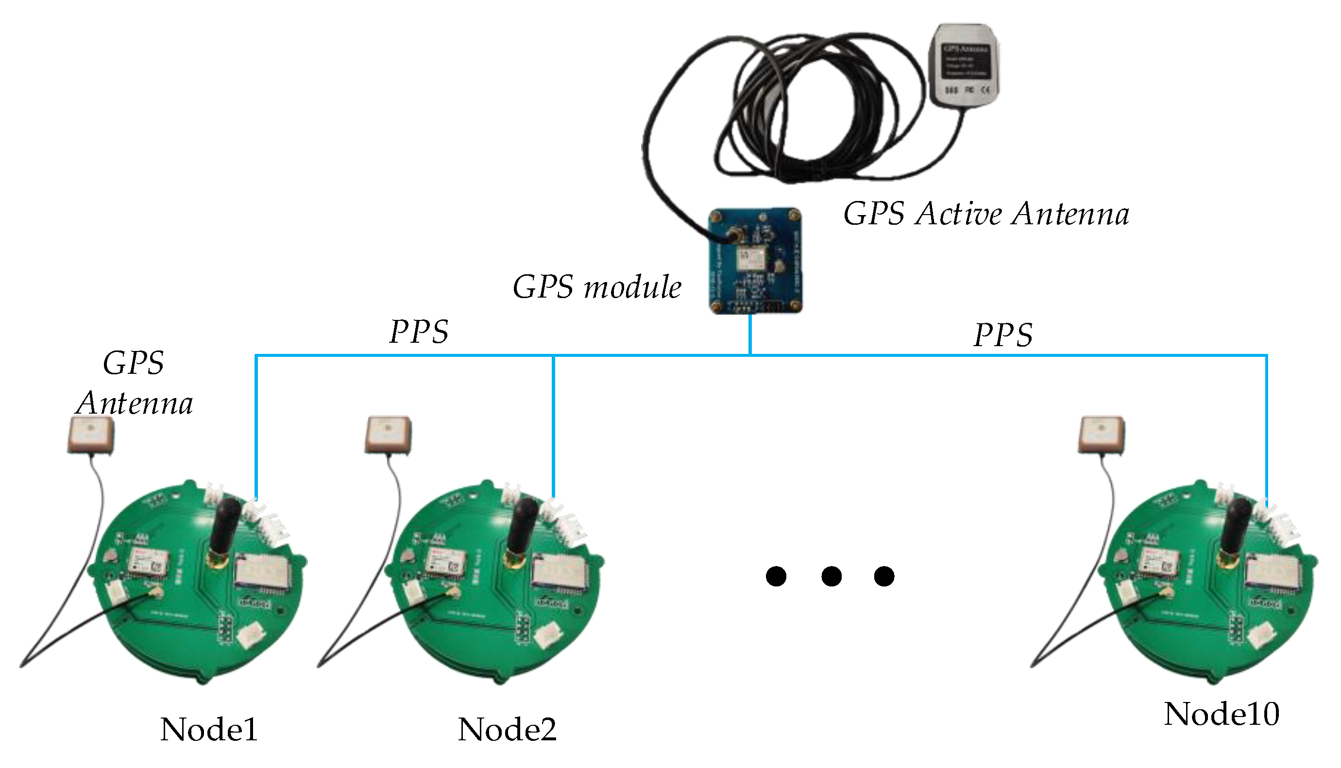
The node uses the NEO-M8N GPS receiver, which delivers high sensitivity and minimal acquisition times when maintaining low system power. This makes it perfectly suited for high-density seismic surveys with complex environments (some places with weak GPS signal) for long periods. Protocols and interfaces of the NEO-M8N mainly include the UBX with a binary format and NMEA 0183 with ASCII format [25]. In UBX format, GPS is defined by week number and seconds-of-week. This protocol uses 8-bit binary data, a low-overhead checksum algorithm, and a 2-stage message identifier (Class and Message ID), which transmit fewer bytes when getting valid information compared to the NMEA format. The UBX protocol is selected as the message output format to transmit GNSS data to GEIWSR-III.
According to the launch strategy, the time synchronization operation designed in this paper is divided into periodic synchronization at a certain time interval, continuous-time synchronization, and forced time synchronization. Periodic synchronization at a certain time interval starts the time-synchronization operation at a specified sampling point interval. This requires setting a counter and takes a snapshot of the GPS time and the amount of ADC data points when the sampling points meet a certain number. Then we use this snapshot to align the data later. When encountering a failure of the current GPS timing, we use the continuous-time synchronization mode, which continuously monitors the GPS timing and performs the GPS time snapshot operation as soon as the timing is successful. Forced time synchronization uses the wireless monitoring system of the node for time synchronization. When the node receives the mandatory GPS time snapshot event instruction, it searches for timing information immediately. If the timing is successful, it executes the GPS time snapshot and returns a success message to the control center. If the timing fails, it returns a GPS time snapshot failure message and then enters continuous synchronization mode.
GEIWSR-III generally only takes periodic synchronization at a certain time interval mode when in a fine GPS signal. However, setting GPS to continuous mode consumes a lot of energy. We propose a low-power solution based on the GPS operating mode. After the GPS provides time service, it sleeps. When it is the time that the GPS provides time service, it wakes the GPS. The sleep and wake of GPS are realized by the MCU sending UBX instructions to GPS. Figure 8 shows the working state of GPS in power save mode and continuous working mode.
In power save mode, the GPS wake-up operation must be completed before GPS provides time service in order not to miss a sampling point. The time relationship is shown as follows:
Δ T t s l e e p + t c s
where t s l e e p is the GPS sleep time, t c s is the cold start time. In general, t c s is about 2 s. The average power consumption is about 20 mW in GPS sleep mode, and the average power consumption is about 75 mW in GPS continuous mode. Thus, the power save mode would save 73% of the total energy compared to the continuous mode in a time service cycle.
As shown in Figure 9, the entire acquisition and time-synchronization workflow of the seismograph is divided into five phases:
  • GPS positioning: The node performs a self-test immediately after the system is powered on. When the self-test is completed, it immediately enters the GPS positioning task. After the valid GPS information is obtained for the first time, the GPS time information is extracted as the time-synchronization folder name and time-synchronization file name.
  • Record seismic data: The seismic data FIFO size is set to 4 kbytes. The FIFO size is detected and written to the SD card at one time when the FIFO is full. If the node collects at a sampling rate of 1000 sps and each data point occupies 4 bytes, then the amount of data generated per second is 4 kbytes. That is, an SD card data-write operation will be performed every second.
  • Trigger synchronization time: The setting of this time is given by Equation (4). Set a variable to count the number of FIFO writes. When the count reaches the trigger time, it notifies the GPS serial data output interrupt and PPS interrupt to start time-synchronization.
  • Time synchronization: The ADC generates an interrupt through the DRDY pin. When a DRDY interrupt occurs, a data point is the output. A variable is set to count the number of data points. When a time synchronization event occurs, the amount of data point generated by the ADC, and the accurate GPS time is stored as a time-sync file in the SD card.
  • Close file: When the detected seismic data file size reaches the set block size, close the current data file and create the next data file. At the same time, the ADC count is cleared and the counter is started again, and so on, until the end of the acquisition task.
Calculating the local time from GPS time to UTC time mainly uses two parameters, GPS week number and GPS milliseconds time of the week [26]. In order to record the synchronization information accurately, we have designed a 1-s time series, which is between the output time information of the mm second pulse and the output time information of the (mm + 1000) second pulse, as shown in Figure 10.
T 0 in the time series is the point of time when encountering GPS serial data output interrupt, and T 1 is the point of time when a PPS interrupt event is encountered. Since the rising edge of the 1 PPS pulse of the GPS receiver is the starting point of the second and the time series length is 1 s if the GPS serial interruption time corresponds to T 0 ( nn :   mm ) , then the recorded time is ( T 0 + 1 ) .
According to the time series, the reasonable workflows in the GPS serial interrupt (corresponding to T 0 ) and PPS interrupt (corresponding to T 1 ) service programs are shown in Figure 11.
The function of workflows is used to ensure that the same PPS interruption corresponds to the same GPS information on the premise of not affecting the main program to record seismic data. In GPS serial interruption, UBX packet is received and parsed for every second. After obtaining GPS information and parsing the UBX packet, it will detect the valid bit until the GPS data is valid. If GPS serial interruption checks the snapshot event from the main program at this time, it records the time series T 1 (nn, mm + 1000) as the current real-time GPS time. When the PPS interrupt service function detects that the serial interrupt has obtained valid GPS information, it sets the time synchronization valid bit to notify the main program that a snapshot event has been performed. In this way, the GEIWSR-III completes time synchronization for high-density seismic array surveys.

3. Performance Evaluation and Field Measurement for Validation

3.1. Performance Evaluation

GPS satellites are equipped with high-precision atomic clocks to achieve high-precision GPS timing. The satellite operating status parameters are continuously tracked and measured by ground monitoring stations [27]. They transmit orbit and time information to the GPS receiver through navigation messages (e.g., observation values, carrier and code phases, Doppler and carrier-to-noise values). The satellite clock error parameters are calculated in conjunction with the standard GPS time provided by the observatory and ground monitoring stations. The receiver gets GPS accurate timing after solving the data, and the synchronization accuracy is about 10~100 ns [28]. The GPS receiver NEO-M8 is a multi-constellation L1-frequency receiver. The synchronization error mainly comes from the accuracy error of the synchronization pulse from the GPS receiver in the entire network and the TCXO timing error of each sensor node. Satellite clocks age and drift. Indeed, satellite clocks are rubidium or cesium atoms with relative stable frequency drift, but each satellite has its own clock drift. Thus, the position solution is a hyperbolic problem due to the different clocks aligned in the system. Even though the clock offset and clock drift is relatively low compared to the external clock drift of the sensor node. Each sensor node uses an independent TCXO in its data acquisition unit, so there is a random phase difference in the master clock of different sensor nodes, which will cause ADC synchronization errors. If the phase difference between the main clocks of the two sensor nodes is 180° according to Figure 6, assuming that there is no error in the synchronization signal SYNC, which is derived from the PPS signal of GPS receiver, the maximum synchronization error is one master clock cycle after the two sensor nodes are synchronized with the signal. Obviously, the GPS timing error adding the master clock phase error produces the overall synchronization error. Therefore, the synchronization accuracy of the proposed time synchronization method in the whole sensor network can be expressed as follows:
Δ t e r r o r = ±   1 / f c l k + t G P S
where the f c l k represents the main clock cycle of the ADC, t G P S represents the synchronization error of the GPS The main clock frequency of the ADC is 4.096 MHz and the maximum of t G P S is 60 ns according to the NEO-M8N specification. Therefore, the synchronization accuracy of the proposed time synchronization method is ± 0.3 μs, i.e., 0.6 μs. Further, the synchronization error does not change with time and the number of sensor nodes.
In order to verify the performance of the proposed time synchronization method, we conducted an in-situ test and field measurement. In the in-situ test, we designed a verification method to test the stability of time synchronization of multiple nodes and the stability of time synchronization with time. Further, we have actually verified the time synchronization method in the field. The instrument parameters used are shown in Table 2.

3.2. Synchronization Stability Test

The described time synchronization method is experimented in the field for validation. We set up a GPS module as a signal source to generate PPS signals. Ten sensor nodes are distributed in different random locations, and they collect the PPS signals continuously. The schematic of the time synchronization stability test is shown in Figure 12. Each sensor node has its own GPS and active antenna, which time-stamps the PPS data. In addition, each node uses the proposed T3I method to test the synchronization performance of the system at different locations. The test time was from 8:00 a.m. on 2 November to 8:00 a.m. on 25 November 2019. Figure 13a shows the time synchronization stability of the different nodes in different locations on the 15 November 20:00 p.m., and Figure 13b shows the long-time stability for the first node at 20:00 p.m., with the step of 3 days from the test time. The PPS signal output by the GPS module is a step signal. Actually, the signal collected by these nodes is the minimum phase response of this step signal. The parameters of the instruments are shown in Table 2.
Figure 13a shows that the PPS signals are on one curve from the ten nodes, which indicates that the time synchronization method has good stability for the distribution of multiple nodes at different locations. Figure 13b shows that the time synchronization changes with time in the performance of the sensor node are negligible.

3.3. Field Measurement I

In this section, we did a field measurement to verify the time synchronization performance of the acquisition nodes. We put 12 sensor nodes on the specific point together and then hit the ground with a hammer source about 5 m away from the center of the collection node cluster. We used a base plate on the ground to make the seismic wave spread uniformly. During the experiment, the host computer is used to set the sampling rate of 1000 Hz for GEIWSR-III through the wireless monitoring system. Other parameters of the GEIWSR-III are shown in Table 2. The sensor nodes are deployed in one field experiment, which is shown in Figure 14a, and the waveform of the recorded seismic data is shown in Figure 14b. Note that the origin of the coordinates is not the starting point of the test time, but the starting point of the time period when we use data processing software for time interception. It can be seen from the figure that the first arrival of the seismic waves in the 12 sensor nodes is strictly aligned on the same horizontal line.

3.4. Field Measurement II

To evaluate the reliability and performance of the proposed time synchronization method by the sensor node for seismic exploration, a field survey was conducted on the Chaoyang campus of Jilin University. At the survey location, 17 sensor nodes are arranged in a row with 2.5 m pitch, as shown in Figure 15a. Then we did a hammer test at 3 m from the 9th node. The exploration test took about one hour. Other parameters of the GEIWSR-III are set in Table 2. The test results are shown in Figure 15b. All instruments have good consistency and synchronization, which fully meet the requirements of the time synchronization of all nodes in high-density seismic array surveys.

4. Results and Discussion

High-density seismic array surveys need to be deployed in a large-scale exploration environment and a long exploration period, which places strict requirements on the time synchronization performance between multiple nodes. The time synchronization performance is significantly affected by sensor node localization, the number of nodes, and the exploration time. In high-density seismic array surveys, it is crucial to adopt an energy-efficient data time stamp system and time synchronization method.
We propose the T3I method for time synchronization based on the GEIWSR-III system in this paper. According to the structure of the time synchronization platform and the energy-efficient requirements, we analyzed the clock architecture of the data acquisition system and different performance indicators of the clock. Finally, we determined the method of using GPS intermittent timing and TCXO continuous timing for time stamping. At the time when a data point is not missed, multi-node time synchronization is achieved by recording and updating GPS time in the SD card.
The performance evaluation shows that the accuracy of this method only depends on the accuracy of the GPS and a clock period of the data acquisition system. The synchronization stability test proves that the stability of the time synchronization proposed in this paper does not change with time and space during the working time of the instrument, which is in line with the original intention and expectations. Field Measurement I shows that the hammer signals are kept in sync when they are placed in a pile. Field Measurement II shows that the hammer signals between nodes still have strong time synchronization performance when maintaining the same node spacing. Due to the time synchronization accuracy of the proposed method in this paper only depends on the accuracy of GPS and local TCXO, the synchronization performance of nodes has nothing to do with the distance between nodes and the exploration time, so that the synchronization method proposed in this paper can be applied to high-density seismic array surveys.

5. Conclusions

Aimed at the time synchronization problem of multiple sensor nodes in the high-density seismic array exploration method, we propose an energy-efficient time synchronization system that uses GPS and a high-precision TCXO based on the GEIWSR-III system in this paper. For energy-efficient design, we used the way that GPS works intermittently, TCXO provides time service continuously. We can save 73% of the energy compared to continuous GPS timing. After time-stamping the seismic data, we record accurate time, which is based on a strict time series in the SD card so as to intercept seismic data when seismic data is collected.
After analyzing the performance of the time synchronization method, it is found that the synchronization accuracy depends only on the timing accuracy of the GPS and the clock cycle of the acquisition system. When the clock synchronization is stable, the sensor node can achieve a synchronization accuracy of about 0.6 μs. Synchronization stability tests and the field measurements also prove that the time synchronization method has strong practical application ability, which meets the requirements of efficient acquisition tasks for high-density seismic array survey. In future work, we will produce more sensor nodes and further verify the performance of this time synchronization method in a wide range of exploration work.

Supplementary Materials

Supplementary File 1

Author Contributions

J.L., H.Y., and L.Z.: conceptualization; R.T., J.Z., and H.Y.: conceived and designed the instruments; R.T., S.Z., Y.C., L.W., and H.Y.: performed the experiments; R.T., J.Z., Y.C., and Y.J.: validation and formal analysis; R.T.: writing—original draft preparation; R.T., S.Z., and H.Y.: writing—review and editing; J.L., H.Y., and L.Z.: project administration. All authors have read and agree to the published version of the manuscript.

Funding

This work was supported by the National Key R&D Program of China (Grant No. 2018YFC0603204), the Ph.D. Interdisciplinary Research Funding Project of Jilin University (Grant No. 10183201836), National Natural Science Foundation of China (Grant No. 41204069), New Energy Special Project of Jilin Province-University Construction Special Project (Grant No. SXGJSF2017-5), and Research on Key Techniques of Micro Seismic Joint Electrical Monitoring for Improving Production of Oil and Gas in Hydraulic Fracturing of Jilin Provincial Department of Science and Technology, Key Scientific and Technological Project (Grant No. 20160204068GX).

Acknowledgments

Any opinions, findings, conclusions and recommendations expressed in this paper are those of the authors. Authors would also like to thank anonymous reviewers who have provided many helpful comments on the manuscript.

Conflicts of Interest

The authors declare no conflict of interest.

References

  1. Liu, Z.; Sa, L.; Dong, S.; Tang, D. Practices and expectation of High-Density seismic exploration technology in CNPC. Pet. Explor. Dev. 2009, 36, 129–135. [Google Scholar]
  2. Tian, R.Y.; Lv, S.X.; Lin, J.; Zhang, L.H. Key techniques of single channel wireless storage seismograph. Chin. J. Geophys. 2017, 60, 4273–4281. [Google Scholar]
  3. Wang, S.J.; Lu, C.; You, Q.Y.; Zhang, Y. Design of a low cost Non-Cable seismic acquisition station. Chin. J. Geophys. 2015, 58, 1425–1433. [Google Scholar]
  4. Tian, R.Y.; Wang, L.X.; Zhou, X.H.; Xu, H.; Lin, J.; Zhang, L. An integrated Energy-Efficient wireless sensor node for the microtremor survey method. Sensors 2019, 19, 544. [Google Scholar]
  5. Sercel WTU-508. Available online: http://www.sercel.com/products/Lists/ProductSpecification/WTU5.08_brochure_Sercel_CH.pdf (accessed on 5 March 2019).
  6. RT3. Available online: https://wirelessseismic.com//wp-content/uploads/2017/09/01_RT3_datasheet.pdf (accessed on 22 July 2019).
  7. Picozzi, M.; Milkereit, C.; Parolai, S.; Jaeckel, K.H.; Veit, I.; Fischer, J.; Zschau, J. GFZ wireless seismicarray (GFZ-WISE), a wireless mesh network of seismic sensors: New perspectives for seismic noise array investigations and site monitoring. Sensors 2010, 10, 3280–3304. [Google Scholar] [CrossRef] [PubMed] [Green Version]
  8. Dai, K.S.; Li, X.F.; Lu, C.; You, Q.Y.; Huang, Z.H.; Wu, H.F. A Low-Cost Energy-Efficient cableless geophone unit for passive surface wave surveys. Sensors 2015, 15, 24698–24715. [Google Scholar] [CrossRef] [PubMed] [Green Version]
  9. Jiang, X.; Lin, J.; Ye, F.; Zheng, F. Separation of P–P and P–SV wavefields by high resolution parabolic Radon transform. J. Appl. Geophys. 2015, 119, 192–201. [Google Scholar] [CrossRef]
  10. ZLand-3C Node. Available online: http://fairfieldgeo.com/media/pdfs/ZLand-3C-spec-sheet-2018.pdf (accessed on 12 August 2019).
  11. Lu, C.; Wang, S.J.; Zhang, Y.; Dai, K.S.; Zhang, Y. A new Low-Cost No-Cable digital geophone for microtremor survey. Chin. J. Geophys. 2015, 58, 2148–2159. [Google Scholar]
  12. Malehmir, A.; Dynesius, L.; Sjölund, T. Time-Synchronized Geophysical Investigations in Denied GPS-Time Spaces. In Proceedings of the 1st Conference on Geophysics for Infrastructure Planning Monitoring and BIM, Hague, The Netherlands, 8 September 2019. [Google Scholar]
  13. Du, L.Z.; Qiu, J.H.; Zhang, Q.; Zhang, X.P. Development and application of a High-Fidelity and High-Resolution telemetry seismic data acquisition system. Chin. J. Geophys. 2019, 62, 3964–3973. [Google Scholar]
  14. Lamport, L. Time, clocks, and the ordering of events in a distributed system. Commun. ACM 1978, 21, 558–565. [Google Scholar] [CrossRef]
  15. Gao, N.; Zheng, F.; Wang, X.; Jiang, X.; Lin, J. High-Speed download of seismographs using private cloud technology and a proportional integral derivative controller. Instrum. Sci. Technol. 2016, 44, 12–22. [Google Scholar]
  16. Ringler, A.T.; Anthony, R.E.; Karplus, M.S.; Holland, A.A.; Wilson, D.C. Laboratory tests of three Zland fairfield nodal 5-Hz, Three-Component sensors. Seismol. Res. Lett. 2018, 89, 1601–1608. [Google Scholar] [CrossRef]
  17. Quantum. Available online: http://www.mitchamindustries.com/PDF/Inova-Quantum_Datasheet.pdf (accessed on 16 August 2019).
  18. Jiang, J.; Yang, R.; Wang, B.; Xiang, Y.; Pang, W.; Yang, J.; Ye, B. Assessing Short-Term clock errors and drifts of temporary seismic networks using the active airgun source in Binchuan, Yunnan. Seismol. Res. Lett. 2019, 90, 2165–2174. [Google Scholar] [CrossRef]
  19. Taborda, R.; Azizzadeh-Roodpish, S.; Khoshnevis, N.; Cheng, K. Evaluation of the southern California seismic velocity models through simulation of recorded events. Geophys. J. Int. 2016, 205, 1342–1364. [Google Scholar] [CrossRef] [Green Version]
  20. Tian, R.Y.; Wang, L.X.; Jiang, Y.J.; Lin, J.; Zhang, L.H.; Zhou, X.H. Wireless Multi-Hop Energy-Efficient system for High-Density seismic array. IEEE Access 2020, 8, 26054–26066. [Google Scholar] [CrossRef]
  21. Buono, P.L.; In, V.; Longhini, P.; Olender, L.; Palacios, A.; Reeves, S. Phase drift on networks of coupled crystal oscillators for precision timing. Phys. Rev. E 2018, 98, 012203. [Google Scholar] [CrossRef] [PubMed] [Green Version]
  22. Zhao, X.; Laverty, D.M.; McKernan, A.; Morrow, D.J.; McLaughlin, K.; Sezer, S. GPS-Disciplined Analog-To-Digital converter for phasor measurement applications. IEEE Tran. Instrum. Meas. 2017, 66, 2349–2357. [Google Scholar]
  23. Gobato, R.; Gobato, M.R.R.; Heidari, A. Rhodochrosite as Crystal Oscillator. Am. J. Biomed. Sci. Res. 2019, 3, 187. [Google Scholar] [CrossRef] [Green Version]
  24. Knappe, S.; Gerginov, V.; Schwindt, P.D.D.; Shah, V.; Robinson, H.G.; Hollberg, L.; Kitching, J. Atomic vapor cells for Chip-Scale atomic clocks with improved Long-Term frequency stability. Opt. Lett. 2005, 30, 2351–2353. [Google Scholar] [CrossRef] [PubMed] [Green Version]
  25. UBLOX M8N GNSS Module. Available online: https://www.u-blox.com/sites/default/files/NEO-M8-FW3_DataSheet_%28UBX-15031086%29.pdf (accessed on 10 May 2020).
  26. Gps Week Number Roll-Over Workaround. Available online: https://www.u-blox.com/en/docs/UBX-19016936 (accessed on 12 May 2020).
  27. GPS-ICD. Available online: https://www.gps.gov/technical/icwg/IS-GPS-200K.pdf (accessed on 12 May 2020).
  28. Guo, H.; Crossley, P. Design of a time synchronization system based on GPS and IEEE 1588 for transmission substations. IEEE Trans. Power Deliv. 2016, 32, 2091–2100. [Google Scholar] [CrossRef] [Green Version]
Figure 1. Schematic diagram for time synchronization in the high-density seismic array survey.
Applsci 10 03768 g001
Figure 2. Double-receiver model of seismic reflection survey.
Applsci 10 03768 g002
Figure 3. Block diagram of the time-synchronization platform GEIWSR-III.
Applsci 10 03768 g003
Figure 4. The simplified system working flowchart of GEIWR-III.
Applsci 10 03768 g004
Figure 5. Architecture of the time-synchronization system.
Applsci 10 03768 g005
Figure 6. The timing for continuous-sync and data output mode.
Applsci 10 03768 g006
Figure 7. Directory structure of seismic data files in the SD card.
Applsci 10 03768 g007
Figure 8. The working state of GPS in power save mode and continuous working mode.
Applsci 10 03768 g008
Figure 9. The workflow of the main program.
Applsci 10 03768 g009
Figure 10. The 1-s time series of GPS time.
Applsci 10 03768 g010
Figure 11. The flow diagram of the GPS serial interruption and PPS interruption.
Applsci 10 03768 g011
Figure 12. The schematic of the time synchronization stability test.
Applsci 10 03768 g012
Figure 13. The results of the synchronization stability test with (a) the time synchronization stability varying in different nodes and (b) the time synchronization stability varying with time.
Applsci 10 03768 g013
Figure 14. Field measurement with the sensor nodes in a pile (a) the sensor nodes are deployed in one field experiment and (b) the waveform of the recorded seismic data.
Applsci 10 03768 g014
Figure 15. Field measurement with the sensor nodes in equal intervals. (a) The sensor nodes are deployed in second field experiment and (b) the waveform of the recorded seismic data.
Applsci 10 03768 g015
Table 1. Main indicators of the crystal oscillator.
Main Indicators/TypeVCXOOCXOTCXO
Frequency Shift by Temperature (ppm) 15–250.0005~0.10000.1–5.0
Frequency Aging (ppm/week)0.1(3~100) × 10−40.01
Frequency Tolerance (ppm)1–250.5~50.5–5
Power Consumption (mW)5–100(1~40) × 10315–200
Table 2. Main parameters of the measurement.
Main Indicators/TypeValue
Sampling Rate (sps) 1000
Gain (dB)0
SYNC Mode GPS + TCXO
Digital Filter Sinc + FIR + IIR
High-pass Cut-off Frequency (Hz)200
Low-pass Cut-off Frequency (Hz)0.1

