
Virtual Reality for Spatial Planning and Emergency Situations: Challenges and Solution Directions


1
Laboratory of Geo-Information Science and Remote Sensing, Wageningen University & Research, GAIA Building (101), P.O. Box 47, 6700 AA Wageningen, The Netherlands
2
Information Technology Group, Wageningen University and Research, Building No. 201 (Leeuwenborch), Hollandseweg 1, 6706 KN Wageningen, The Netherlands
*
Author to whom correspondence should be addressed.
Appl. Sci. 2024, 14(9), 3595; https://doi.org/10.3390/app14093595
Submission received: 25 March 2024
/
Revised: 16 April 2024
/
Accepted: 17 April 2024
/
Published: 24 April 2024
(This article belongs to the Special Issue Recent Research on Digital Reality)
Abstract
:The notion of the smart city involves embedding Industry 4.0 technologies to improve the lives of inhabitants in urban environments. Within this context, smart city data layers (SCDLs) concern the integration of extra tiers of information for the purposes of improving communication potential. Under the Industry 4.0 technology grouping, advanced communication technologies, such as virtual reality (VR), further the opportunities to model, recreate, evaluate and communicate scenarios that potentially improve citizens lives at multiple SCDL scales in a smart cities context. The use of added contextual information in SCDLs is of special interest for emergency planning situations at the building scale. In this research, a literature review to understand the current approaches for the use, development and evaluation of VR applications in the context of emergency planning was conducted. The results indicated four main categories of relevant challenges for these types of applications, for which recommendations and a roadmap for VR development are presented. In total, the study identified 10 commonly occurring challenges (e.g., optimization and discomfort) and 19 solution directions (e.g., model construction and spatial directions) in related articles when considering the development of VR for spatial planning and emergency situations.
1. Introduction
Virtual reality (VR) is a technology that allows users to experience a sense of place that is comparable or even identical to the real world [1]. Although the first forms of VR date back to the 1960s, with later applications in building design in the 1970s [2], the modern head-mounted device that is accessible to the general public was only developed for widespread commercial uptake in the past decade [3], with the Quest Go being a particularly prominent factor in this realization [4]. An advantage of using VR over real-world experiments is the safe environment in which emergencies can be experienced by participants [5]. In addition, the costs for a VR experiment are relatively low in comparison to a real-world study, and a VR application can be used repeatedly, thus making the technology’s uptake readily scalable and affordable [6].
Additionally, when compared to traditional 2D methods (i.e., maps and images), VR has been shown to improve a person’s ability to recognize objects and to remember what they saw [7]. An advantage of using VR for smart city applications (e.g., for spatial planning and emergency situations) is that the technology can contribute to displaying extra layers of information on top of the original environment, in essence, bringing immersive experiences [8]. Jaime et al. [9] describe these layers of information as Data Layers (DL). Displaying these DLs improves communication and, therefore, the understanding of designs or existing places [9].
Following this concept of DL and information generated for smart city management, the concept of layers showing extra information and data together with the real environment will be referred to as smart city data layers (SCDLs) in this article. The notion of the smart city has gained prominence over the last 15 years. Yet, considering the twenty-three different definitions that have been found by [10], there is no single agreed-upon definition. However, what all definitions of a smart city have in common is the identification that Industry 4.0 technologies should be present and should improve the lives of the inhabitants [11]. To design a smart city, it is essential to have effective communication between clients, designers, communities and decision-makers [9]; thus, investigations of the integration of DLs are gaining prominence for spatial planning and emergency situations. However, for clarity, this communication does not necessarily need to be on the scale of a whole city but can also be localized to, for example, an individual building. This is because one of the critical components of a smart city is public safety [12]. At the building level, public safety can be increased by improving the individual’s knowledge of emergency routes. During an evacuation, wayfinding skills are of great importance and can contribute to the chance of survival [13]. Specifically, there are five factors that influence wayfinding skills in buildings, namely, visual access, architectural differentiation, layout, familiarity and signage. While research on wayfinding and associated factors has traditionally been conducted through real-world experiments, modern visualization techniques, such as VR, have emerged as a viable alternative approach for research [14].
Existing research has shown that VR applications are able to improve wayfinding skills [15] and can be used both by persons visiting a building for the first time or by emergency responders. The technology has also demonstrated a positive impact, with the use of VR tools demonstrating increased chances of survival in emergencies. For example, Bourhim and Cherkaoui [16] developed a VR tool that contributes to public safety by studying pre-evacuation behavior. Besides escaping, users of this application can also choose to help others or extinguish a fire. Wyke et al. [17] also contributed to public safety by using VR to evaluate and improve emergency signage, which is one of the five factors that influence wayfinding skills in buildings. Despite existing works demonstrating the effectiveness of VR, there is a lack of guidance on how to integrate VR and SCDL specifically for emergency situations. Thus, the objective of this research is to perform a review of the existing uses of VR for spatial planning and emergency situations and collate the findings to provide guidance for researchers on best practices for developing VR applications for emergency situations. This will be achieved by addressing the following research questions:
- (1)
- What are the challenges and solution directions of VR applications for emergency situations in buildings?
- (2)
- What roadmap/recommendations can be derived from the scientific literature when designing and developing a VR application for the evaluation of emergency routes?
To address these questions, this study involved a literature review of related survey articles on the use of VR for spatial planning and emergency situations followed by a domain analysis by means of a keyword search in the Scopus digital library, whereby challenges and solution directions were identified through the literature analysis. As such, the remainder of this paper is as follows. Section 2 provides a background investigation into related work, highlighting key differences to this study. Section 3 documents the methodology adopted for the review. The findings are presented in Section 4, a discussion is presented in Section 5 and the paper is concluded in Section 6.
2. Related Work
In this section, focus is placed on related articles concerning literature reviews on using VR in a smart city setting. As literature reviews, the articles documented were omitted from the domain analysis process (as detailed in Section 3). However, the works are included here to provide scope for this study.
VR for Smart City Applications
In their literature review, Jamei et al. [9] provide the following four distinct use cases for adopting VR for creating sustainable smart cities, specifically: (1) visualizing pedestrian thermal comfort, (2) visualizing smart transportation, (3) data management and (4) visualizing the cognitive behavior of urban dwellers. These use cases are directly related to four out of the seven critical components of a smart city previously defined in a study by Washburn et al. [12] (i.e., utilities, transportation, city administration and real estate). The remaining three (education, healthcare and public safety) are addressed in other studies, such as the one by Parikh et al. [18], who created a VR application for educational purposes. Their tool educates people regarding urban agriculture to accelerate innovations in food justice. For healthcare purposes, Kim et al. [19] found that VR can help to reduce costs and increase quality, yet for public safety (specifically regarding the built environment), the existing research on using VR in a smart cities context is somewhat limited.
Other existing literature reviews focus on the wider application of VR for spatial planning and emergency situations. Our search identified six prominent articles (by means of a snowballing search), of which the main focus and the categories in which the authors divided their findings are presented in Table 1 together with the corresponding keywords for the literature review search in the paper. These keywords were later used to construct the search query adopted in this review article (Section 3.1).
3. Methodology
For the purposes of evaluating the approaches the existing papers currently employ for the development, deployment and evaluation of a VR application for emergency situations, a domain analysis was conducted. For the identification and selection of relevant articles a systematic literature review (SLR) methodology was adopted [23], which is a technique employed in other smart city-based literature reviews [24]. First, a query was composed, which was an iterative process in which more keywords were added, inspired by keywords from the review articles that were identified in Table 1 in Section 2.
3.1. Search Query
The query below in (1) resulted in 254 papers identified in the Scopus digital library by searching the title, abstract and keywords. All publications identified were from between 1995 and 2022, but as shown in Figure 1, the number of publications showed an upward trend from 2011. The umbrella terms smart city, Industry 4.0, etc., were not included in the search string, as the focus was on VR as a sub-field in this domain.
TITLE-ABS-KEY ((vr OR virtual AND reality)
AND (emergency OR emergencies OR evacuation)
AND (escap* OR wayfinding OR route OR exit))
AND (emergency OR emergencies OR evacuation)
AND (escap* OR wayfinding OR route OR exit))
3.2. Filtering
For these 254 results, the data were downloaded as a .CSV to obtain an overview of the research that is being conducted in this domain. The .CSV data were imported to Jupyter Notebook for analysis. The results of the analysis were visualized using the matplotlib, pandas and numpy libraries.
Due to the rapid advancement in VR technology development, only papers that have been published since 2018 were used for the literature review to ensure that the techniques are comparable. This was carried out to align with the release of the Oculus Go, the first completely portable VR device. Further, papers that are not available in English were excluded from this research. With these criteria, 129 remained.
However, it should be noted that the search query generated a minor number of articles (22) that are similar to this research but use a different technique, such as the article by Yoshimi et al. [25], which concerns an augmented reality (AR) application rather than VR. These 22 papers could be excluded by their title and keywords. For the 107 remaining articles, the abstract was reviewed to check for relevance again. The article filtering process and the count at each filtering stage are presented in Figure 2.
When the article was deemed relevant based on the abstract, the article contents were reviewed, including the methods and results sections. Works that demonstrated a focus on the design phase of the application (15), were selected for further specific analysis (see Figure 2) relating to actual prototype design. From these selected papers, challenges and solution directions were assembled and grouped into four categories. These categories are based on reoccurring themes from the literature review and on the findings from the related survey articles in Section 2.
The four categories were as follows: (1) application design, (2) user experience, (3) collecting results and (4) evaluating the application. The challenges and issues of each were taken into account and are discussed in Section 4. These findings can support future prototype application development by other researchers.
4. Results
The keywords for the original 254 papers were summarized in a radial histogram (Figure 3) with the keyword VR removed, as that was present in almost every paper and, therefore, both distorted and dominated the radial histogram. A total of 1926 unique keywords were present within the different articles. Due to this high volume, only keywords that were present in at least five papers are displayed in Figure 3. Green keywords were mentioned 5–10 times, blue keywords 11–20 times, purple keywords 21–30 times, orange keywords 31–53 times and the most mentioned keyword (57 times) is displayed in red.
Regarding the final 15 papers, on average, the papers were cited 18 times each. A total of 13 of the papers are articles that have been published in 10 different journals. Seven of those journals have a Q index of 1 and two have Q index of 2. Challenges and solution directions that were extracted from the final selection of the articles were described by means of the four aforementioned categories outlined in Section 3.2.
4.1. Application Design Approaches
Regarding the approaches for the application design, 13 papers focused primarily on digitally creating/recreating an actual 3D building model. The choice of starting first with the building model construction over asset content is justified by the authors of [16], who state that it is ideal to create a building model for an application in an early stage of the development process. This is because the model influences later choices in the development process.
Kuliga et al. [26] pay considerable attention to the properties that a model for a VR application should have in the case of wayfinding. They argue that the model does not need to be photorealistic and, therefore, does not need to be highly detailed. Instead, it is more significant that indicators for improving the participants’ perception of distances and depth are represented. Moreover, the building model should represent the real environment’s geometry and spatial relations exactly, including recognizable objects at the same location as in the real environment.
Approaches for creating a high-quality model can be realized by collecting floorplans, photos and videos of the real environment. Here, high-quality refers to a significant level of convenience [27] (e.g., playability, realism and elimination of errors). The authors also mention that ambiance, such as the correct color schemes, can contribute to creating an optimal model. After the model is completed, it can be imported into a game engine. Overall, for the development process, five software programs were used in total to work on the model development. An overview of the software and hardware that were used per paper is provided in Table 2.
The dominant game engine in the selected papers was Unity (n = 14), which is different to the one in the works by [22], which imported to Unreal. Regarding the importing process, three challenges were identified [26]. First, the 3D coordinate system of the modelling software is often different than the system used in the game engine. Typically, this problem can be solved using the export settings, but is nonetheless recognized in the articles. Second, imported objects might end up being invisible because they are inverted. An example of a solution to this problem is to create a custom material that colors objects or polygons that are inverted or pre-process the model to flip the normal prior to exporting. Third, the Z-fighting phenomenon might occur. This results in two or more objects flickering because they are in the exact same (XYZ) location, thus causing conflict during the render process. This, of course, can be solved by moving one of the objects slightly. Lovreglio et al. [33] continue by improving their model with objects that were obtained from the Unity Asset Store. From there, they downloaded their doors and some pieces of furniture that were not available in their chosen modelling software.
To be able to use a VR hardware device, a support package corresponding to the chosen VR headset should be downloaded and integrated. Next, walkable areas should be added using floor colliders, and mesh colliders should be added to other objects [37]. A bounding box should be used to make sure the user of the application does not go outside of the walkable area. Next, a first-person controller (FPC) should be integrated. This FPC is essential for a wayfinding VR application, as without it, the user cannot move through the model or scene.
With this FPC, the speed can be edited, and the exact location and movement of the participant can be recorded [38]. Recording this is needed to obtain results, and for this process, [36] used a custom logger script to export the exact location and movement to a .CSV file. Similarly, [22,38] recorded the positions at a frequency of 10 Hz. Another example is the research of [35], who even recorded information at a frequency of 90 Hz. Lastly, to allow the researchers to enter information such as the participant ID or the version that is going to be used, Kuliga [26] integrated a user interface (UI). The UI also contained the start and finish buttons.
4.2. User Experience Considerations
The optimal frame rate identified in the review process for a smooth VR experience is 90 frames per second (fps). When dropping below 90 fps, a VR experience often causes discomfort or nausea (cybersickness), and it makes the experience less immersive [26]. The same authors give two solutions to achieve a higher frame rate. They describe this optimization as an iterative process, in which a performance bottleneck first needs to be identified. When it is identified, measures should be applied to improve performance. Two common bottlenecks are clusters with a high rate of polygons or materials and objects rendering when they are not visible. For the clusters, a dedicated script can be applied that detects the clusters, and once detected, they can be simplified. The second bottleneck can be mitigated by excluding objects that are not visible from rendering. This was achieved by [34] through the use of the Occlusion Culling algorithm. They also used lightmapping to optimize their application. Next to the frame rate, the speed and the way of walking of the FPC controller strongly influence the user experience to a high degree.
Fu et al. [31] set a speed of 2.5 m/s for two reasons: a higher speed can cause motion sickness and a lower speed can make the experience boring and decrease the participants’ tension. Therefore, the authors outline that 2.5 m/s should be considered by others as a default walking speed for future research applications. To be able to move the FPC, the simplest method is to use the buttons on the VR controller. However, three papers [26,30,35] made use of the swing of the participants’ arms to move in order to increase immersion. To make the VR experience more realistic, three other aspects were added in the selected papers: To make the situation look like a real evacuation, non-player characters (NPCs) could be added to the application. Zhu et al. [20] found that these NPCs caused a higher sense of emergency in their participants. The study in [33] developed a pipeline that explains the development and animation of NPCs in detail. Further, [16,28,29,31,32,33] added smoke and fire. The smoke and fire can be created with Blender or using the particle system effect that is available in Unity. In addition, [22] included a realistic 3D alarm soundscape, which proved to have a positive influence on the reality perceived by their participants.
When all the user experience is implemented, the application should be, of course, tested. Kuliga [26] emphasize the importance of this technical pretesting and state that it could take up to 20% of the development time for the application. The pre-testing should be carried out with real participants, but it does not have to be the full experiment. Select components of the application can be tested, and participants can answer questions and give feedback using an offline questionnaire. After testing, the application is finished, and it can be used for collecting results.
4.3. Collecting Results
A total of 11 out of the 15 selected papers used their application for quantitative research involving the use of participants. The other four papers [26,29,32,37] focused mainly on the development of the application. The articles that involved the use of participants for testing selected 93 participants on average (mean), ranging from 30–226. In six studies, the participants were divided into groups to compare different circumstances. In all those cases, the authors made sure the participants’ genders were balanced to make sure it would not influence the result. For all 11 studies in total, the average size per group was 52 (mean), ranging from 18–181.
All the studies started with an intake. Seven of the papers highlight a consent form that needed to be signed before the experiment started [20,28,31,34,36,38]. This also included an explanation of the cybersickness that could potentially occur. The studies in [20,36] also discussed the inclusion of questions relating to the participants’ basic health to make sure they could participate in their VR experiment. After that, demographic information, such as age and gender, were collected together with information related to the participants’ experience in VR environments.
Ewart and Johnson [30] also asked for the participant’s experience with the building on which their application was based. Within the articles, the experiment process tended to start with giving the VR device to the participant and helping to calibrate it [35,36].
The importance of ethical aspects like announcing when coming close to or touching the participant during the experiment was emphasized by [26]. They also used a mat as the center so that the participants would know when they were not centered anymore to make them feel comfortable. All the studies started with training in the VR environment. While [16] started with an introduction video, the rest immediately started with a training environment to let the user get used to the VR environment and the controls. After the experiment, all the participants were asked to fill in a questionnaire or to conduct an interview about the experience.
4.4. Evaluating Applications
A total of 8 out of the 15 papers evaluated their application using multiple methods, with some papers being more extensive than others. The main factors that were evaluated were usability and presence. One or both of these were evaluated by seven of the papers. Only [37] deviated from this, whereby the authors evaluated the application based on the results their target group achieved over time, and they measured performance during 5 months of using the application.
Ewart and Johnson [30] evaluated usability by means of interviewing their participants about the experience. Their answers were coded and grouped into three aspects: interface and control, experience of the virtual environment and the process of wayfinding. Lovreglio [33] used boxplots for the questionnaire and coding of answers to open questions to evaluate both usability and presence. Likewise, [16] also measured usability but achieved it using the AHP weighting method and fuzzy comprehensive evaluation. Similarly, [34] performed an evaluation but used a confirmatory factorial analysis on four components.
Fu et al. [31] designed their questionnaire based on [39] to measure presence. Lastly, Zhu et al. [20] measured simulator sickness using the simulator sickness questionnaire (SSQ) and presence using the presence questionnaire (PQ). The SSQ is typically employed when testing VR-based applications to measure the levels of nausea and motion sickness, and the PQ assesses the feeling of presence in virtual environments. All of the selected papers evaluated one or more aspects of their application. However, none of them evaluated their application as extensively as [22] did. First, the content validity was measured by comparing the results from the virtual environment to results from other studies that have been conducted in a real environment. The results were compared in three levels of metrics that are used for evaluating wayfinding behavior: decision-making, task performance and observation behavior. Besides the content validity, usability and presence were measured using the face validity questionnaire, the SSQ, the system usability scale (SUS) and the PQ.
5. Discussion
As discussed, the aim of this research was to conduct a review on the application of VR for spatial planning and emergency situations. The resulting findings will provide guidance for researchers on best practices for future development work in this field. We present this guidance by addressing the research questions outlined in Section 1.
5.1. What Are the Challenges and Solution Directions of VR Applications for Emergency Situations in Buildings Currently Discussed in the Scientific Literature?
There is a considerable volume of research that has been conducted on using VR for the built environment for general applications both relating to the solution directions and challenges. Regarding the solution directions, [40] compared a VR- and a paper-based approach to enable users choose between three different urban designs. They found that the people who used the VR application were more certain about their choice and were more engaged in the process. Another example is the research by [41], who found that VR can contribute to the level of participation, especially for younger people. The author also found that VR reduces the time that participants need to understand a design. In addition to showing the design in VR, [42] used an automatic presentation script (APS). This meant that participants went through the design in a fixed route with additional information. The users who got to see the APS understood the design much better than the people who could navigate through the design by themselves. This APS has the same role as the SCDL might have. It is intended to improve understanding of the building, which should result in improved wayfinding skills.
Clearly, there are demonstratable use cases for VR in smart cities, and this is also the case when using VR for evaluating emergency evacuation behavior. An example involves the research by [29], who developed a VR application that uses realistic fire and smoke dynamics to evaluate human behavior in emergency situations, leading to improvements in safety regulations. The same application was further improved by [32]. However, both documented studies focused on developing the application rather than testing it with potential users of the building.
Yet, challenges were identified by [43], who tested their application with participants to compare a scenario with virtual fire and one without. They found that the group using the virtual fire application experienced more stress and took longer to find the exit. Unfortunately, the VR technique used in this research has become somewhat outdated, and, as such, cannot be compared to modern head-mounted VR devices. In the investigation by [28], a more advanced VR device was used, and in their experiment, participants explored a museum in two different ways: exploring with their own route and exploring using a predetermined route. The people who used a predetermined route were able to escape the building faster than the people who explored the building by themselves. Although this application was tested with participants and the VR device was comparable with current devices, no extra data were displayed to influence the results. This also applies to all the other aforementioned examples that used VR for emergency evacuation research.
Initially, in addressing this research question, we were able to consider the challenges and solution directions under the four categories of ‘application design’, ‘user experience’, ‘collecting results’ and ‘evaluating the application’, and these are presented in summary in Table 3.
5.2. What Roadmap/Recommendations Can Be Derived from the Scientific Literature When Designing and Developing a VR Application for the Evaluation of Emergency Routes?
The technical challenges that occurred during the development phase discussed in the articles were grouped into three categories: the model, the game engine and VR. It should be emphasized that the majority of the challenges and solutions are especially suitable for researchers who are also not very experienced with developing VR applications. Other elements recognized concern the model conversion format, whereby the 3D building should be converted to a suitable format to avoid transition errors to avoid a loss of structure in the data, such as difficulties regarding units and the Z-axis. The importance of picking the correct import and export settings was implicitly mentioned by [26].
When a model is unpacked, its import settings can no longer be changed. Later in the process, this can result in problems with lighting settings and materials that are imported, which can both influence the usability of the application. One of the reasons the models were unpacked was to make objects interactable. This was especially the case for doors, which are important in indoor wayfinding studies. This potential problem was also mentioned by [26], which proves the relevance of this point for other researchers. In Table 4, the final recommendations for the use of VR for spatial planning and emergency situations are provided. Thus, in Table 4, an overview of the overarching recommendations is provided in a summary format.
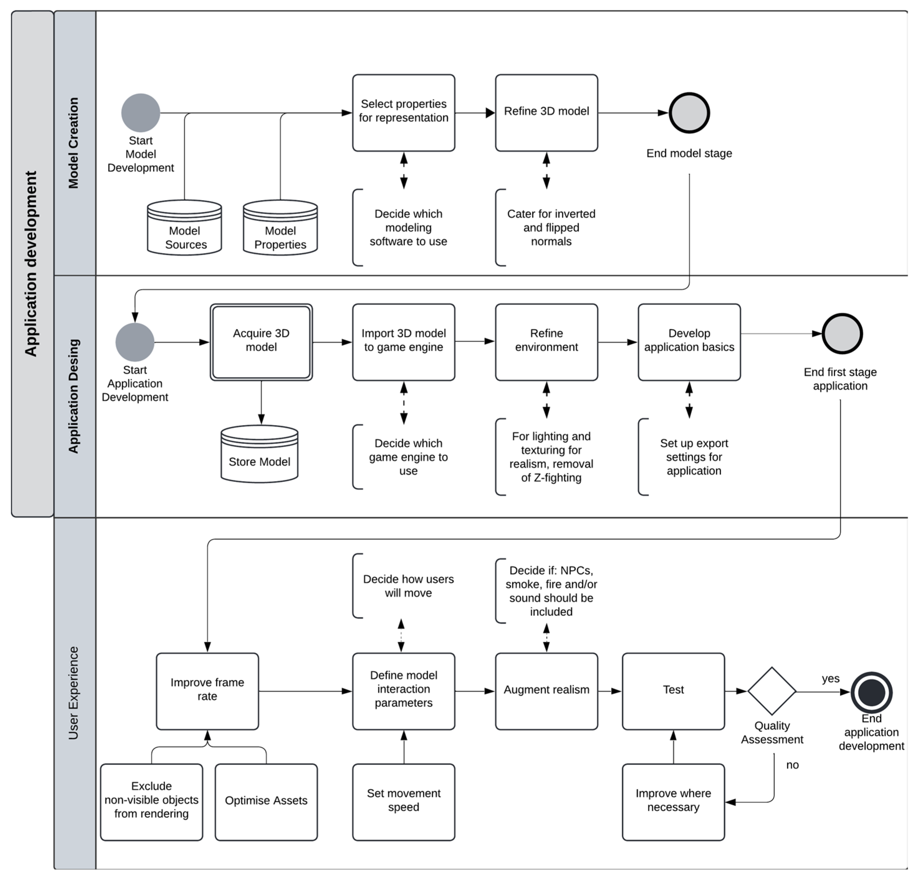
Concerning the proposition of a roadmap, a general approach for future application development can be derived from the findings. In Figure 4, we combine these findings into a framework as a guide for future VR application development for spatial planning and emergency situations.
Figure 4 covers the stages of development as horizontal swim lanes, including creating the model, designing the environment (e.g., importing assets and game engine setup) and developing the user experience (e.g., using and testing the VR application). Bi-directional arrows indicate an interactive decision-making process, whereby refinements are considered by means of artistic expression and practical application suitability. The overall framework indicates a three-stage process, including model sourcing and refining, game engine setup and user experience refinements.
6. Conclusions and Future Work
Multiple challenges and solution directions for using VR for spatial planning and emergency situations were established in this survey. As discussed, the findings can be grouped into four main challenges and solution directions (user experience, collecting results and evaluating the experience) with three further categories of recommendations for other developers (models, game engine and VR).
Further, during the study, we identified that the link between using VR for smart cities and using VR for emergency evacuation has not yet been fully addressed in other studies. Therefore, this research contributed to closing this research gap. Also, a significant component of the findings could be used for developing VR applications that have other purposes beyond solely spatial planning and emergency situations, and there are also potential benefits for coupling with digital twinning applications within a smart city context [44].
This article focused on VR due to the technology’s advantages over other extended reality technologies, such as augmented reality (AR)- and mixed reality (MR)-based approaches. For example, both AR- and MR-based approaches still require use of the physical world to conduct the study, because the technologies blend digital content with the real-world environment, as discussed in our related work [45]. Additionally, AR, VR and MR could be considered as domains worthy of individual investigations due to their widespread and diverse applications within the smart cities context [46]. Therefore, this article focused only on VR. Extensions of this study could consider including AR and MR in the search query.
However, the literature review process resulted in findings that are unique specifically to emergency planning research in buildings using VR, for example, the level of detail that is required or how realism should be increased. Despite the general approach that was created from all the findings, it remains a challenge to reach a consensus from the papers. All the applications were developed in considerably different ways and using multiple combinations of software. Further, the method for collecting results depended on the research aim and can, therefore, not be generalized.
For evaluating an application, a general approach should be possible, as all the papers in the literature review used different approaches, with the application of [22] being the most extensively evaluated. Therefore, research on a general approach to the evaluation of comparable applications would be recommended for future work. A limitation of this literature review is that it did not take the grey literature into account. Conducting this could also help with the recommended research that has been mentioned. Thus, future directions for this research could consider the integration of blogs, tutorials and other material in the grey literature to provide a technology-focused roadmap for VR development.
Author Contributions
Conceptualization, R.W., W.H. and F.R.M.; methodology, R.W.; software, R.W.; validation, R.W.; formal analysis, R.W.; investigation, R.W.; resources, R.W.; data curation, R.W.; writing—original draft preparation, R.W.; writing—review and editing, B.T., W.H. and F.R.M.; visualization, R.W.; supervision, W.H. and F.R.M.; project administration, W.H. All authors have read and agreed to the published version of the manuscript.
Funding
This research received no external funding.
Institutional Review Board Statement
Not applicable.
Informed Consent Statement
Not applicable.
Data Availability Statement
The raw data supporting the conclusions of this article will be made available by the authors on request.
Conflicts of Interest
The authors declare no conflicts of interest.
References
- Çöltekin, A.; Lochhead, I.; Madden, M.; Christophe, S.; Devaux, A.; Pettit, C.; Lock, O.; Shukla, S.; Herman, L.; Stachoň, Z.; et al. Extended Reality in Spatial Sciences: A Review of Research Challenges and Future Directions. ISPRS Int. J. Geo-Inf. 2020, 9, 439. [Google Scholar] [CrossRef]
- Bridgewater, C.; Griffin, M. Applications of Virtual Reality to Computer-Aided Building Design. 1993. Available online: www.witpress.com (accessed on 14 March 2024).
- Edler, D.; Husar, A.; Keil, J.; Vetter, M.; Dickmann, F. Virtual Reality (VR) and Open Source Software: A Workflow for Constructing an Interactive Cartographic VR Environment to Explore Urban Landscapes. KN-J. Cartogr. Geogr. Inf. 2018, 68, 5–13. [Google Scholar] [CrossRef]
- Hillmann, C. Unreal for Mobile and Standalone VR; Apress: New York, NY, USA, 2019. [Google Scholar] [CrossRef]
- Tucker, A.; Marsh, K.L.; Gifford, T.; Lu, X.; Luh, P.B.; Astur, R.S. The effects of information and hazard on evacuee behavior in virtual reality. Fire Saf. J. 2018, 99, 1–11. [Google Scholar] [CrossRef]
- Kinateder, M.; Ronchi, E.; Nilsson, D.; Kobes, M.; Müller, M.; Pauli, P.; Mühlberger, A. Virtual reality for fire evacuation research. In Proceedings of the 2014 Federated Conference on Computer Science and Information Systems, FedCSIS 2014, Warsaw, Poland, 7–10 September 2014; pp. 313–321. [Google Scholar] [CrossRef]
- Çöltekin, A.; Lokka, I.; Zahner, M. On the usability and usefulness of 3D (Geo)Visualizations—A focus on virtual reality environments. In International Archives of the Photogrammetry, Remote Sensing and Spatial Information Sciences—ISPRS Archives; ISPRS: Vienna, Austria, 2016; Volume 41, pp. 387–392. [Google Scholar] [CrossRef]
- Gdel Campo; Saavedra, E.; Piovano, L.; Luque, F.; Santamaria, A. Virtual Reality and Internet of Things Based Digital Twin for Smart City Cross-Domain Interoperability. Appl. Sci. 2024, 14, 2747. [Google Scholar] [CrossRef]
- Jamei, E.; Mortimer, M.; Seyedmahmoudian, M.; Horan, B.; Stojcevski, A. Investigating the Role of Virtual Reality in Planning for Sustainable Smart Cities. Sustainability 2017, 9, 2006. [Google Scholar] [CrossRef]
- Albino, V.; Berardi, U.; Dangelico, R.M. Smart cities: Definitions, dimensions, performance, and initiatives. J. Urban Technol. 2015, 22, 3–21. [Google Scholar] [CrossRef]
- Elvas, L.B.; Marreiros, C.F.; Dinis, J.M.; Pereira, M.C.; Martins, A.L.; Ferreira, J.C. Data-driven approach for incident management in a smart city. Appl. Sci. 2020, 10, 8281. [Google Scholar] [CrossRef]
- Washburn, D.; Cios, U.S.F.; Balaouras, S.; Dines, R.A.; Hayes, N.M.; Nelson, L.E. Helping CIOs Understand ‘Smart City’ Initiatives: Defining the Smart City, Its Drivers, and the Role of the CIO. Growth 2010, 17, 1–17. Available online: www.forrester.com (accessed on 14 December 2022).
- Kobes, M.; Helsloot, I.; de Vries, B.; Post, J.G. Building safety and human behaviour in fire: A literature review. Fire. Saf. J. 2010, 45, 1–11. [Google Scholar] [CrossRef]
- Loomis, J.M.; Blascovich, J.J.; Beall, A.C. Immersive virtual environment technology as a basic research tool in psychology. Behav. Res. Methods Instrum. Comput. 1999, 31, 557–564. [Google Scholar] [CrossRef]
- Irshad, S.; Perkis, A.; Azam, W. Wayfinding in virtual reality serious game: An exploratory study in the context of user perceived experiences. Appl. Sci. 2021, 11, 7822. [Google Scholar] [CrossRef]
- Bourhim, E.M.; Cherkaoui, A. Efficacy of Virtual Reality for Studying People’s Pre-evacuation Behavior under Fire. Int. J. Hum. Comput. Stud. 2020, 142, 102484. [Google Scholar] [CrossRef]
- Wyke, S.C.S.; Andersen, K.M.; Hardahl, M.; Harlyk, M.M.; Vils, E.R.; Svidt, K. Virtual reality use for evaluation and improvement of building emergency signage. In Proceedings of the 2019 European Conference on Computing in Construction, Crete, Greece, 10–12 July 2019; Volume 1, pp. 452–460. [Google Scholar] [CrossRef]
- Parikh, T.; Egendorf, S.P.; Murray, I.; Jamali, A.; Yee, B.; Lin, S.; Cooper-Smith, K.; Parker, B.; Smiley, K.; Kao-Kniffin, J. Greening the Virtual Smart City: Accelerating Peer-to-Peer Learning in Urban Agriculture with Virtual Reality Environments. Front. Sustain. Cities 2022, 3, 161. [Google Scholar] [CrossRef]
- Kim, E.; Lee, M.W.; Jung, C.H.; Park, C.S.; Kim, J.M.; Lee, S.P. Representation of VR-Based Health Information for Smart City. In Proceedings of the Web3D 2020: 25th ACM Conference on 3D Web Technology, Seoul, Republic of Korea, 9–13 November 2020. [Google Scholar] [CrossRef]
- Zhu, R.; Lin, J.; Becerik-Gerber, B.; Li, N. Influence of architectural visual access on emergency wayfinding: A cross-cultural study in China, United Kingdom and United States. Fire Saf. J. 2020, 113, 102963. [Google Scholar] [CrossRef]
- Wolf, M.; Söbke, H.; Wehking, F. Mixed Reality Media-Enabled Public Participation in Urban Planning. In Augmented Reality and Virtual Reality; Springer: Berlin/Heidelberg, Germany, 2020; pp. 125–138. [Google Scholar] [CrossRef]
- Feng, Y.; Duives, D.C.; Hoogendoorn, S.P. Development and evaluation of a VR research tool to study wayfinding behaviour in a multi-story building. Saf. Sci. 2022, 147, 105573. [Google Scholar] [CrossRef]
- Nightingale, A. A guide to systematic literature reviews. Surgery 2009, 27, 381–384. [Google Scholar] [CrossRef]
- Ruhlandt, R.W.S. The governance of smart cities: A systematic literature review. Cities 2018, 81, 1–23. [Google Scholar] [CrossRef]
- Yoshimi, K.; Ratsamee, P.; Orlosky, J. AREarthQuakeDrill: Toward increased awareness of personnel during earthquakes via AR evacuation drills. In Proceedings of the 2021 IEEE Conference on Virtual Reality and 3D User Interfaces Abstracts and Workshops, VRW 2021, Lisbon, Portugal, 27 March–1 April 2021; pp. 446–447. [Google Scholar] [CrossRef]
- Kuliga, S.; Charlton, J.; Rohaidi, H.F.; Isaac, L.Q.Q.; Hoelscher, C.; Joos, M. Developing a Replication of a Wayfinding Study. From a Large-Scale Real Building to a Virtual Reality Simulation. In Lecture Notes in Computer Science (Including Subseries Lecture Notes in Artificial Intelligence and Lecture Notes in Bioinformatics); Springer: Berlin/Heidelberg, Germany, 2020; Volume 12162, pp. 126–142. [Google Scholar] [CrossRef]
- Slob, N.; Hurst, W.; van de Zedde, R.; Tekinerdogan, B. Virtual reality-based digital twins for greenhouses: A focus on human interaction. Comput. Electron. Agric. 2023, 208, 107815. [Google Scholar] [CrossRef]
- Cao, L.; Lin, J.; Li, N. A virtual reality based study of indoor fire evacuation after active or passive spatial exploration. Comput. Hum. Behav. 2019, 90, 37–45. [Google Scholar] [CrossRef]
- Cimellaro, G.P.; Domaneschi, M.; de Iuliis, M.; Villa, V.; Caldera, C.; Cardoni, A. Fire emergency evacuation in a school building through VR. COMPDYN Proc. 2019, 1, 2046–2055. [Google Scholar] [CrossRef]
- Ewart, I.J.; Johnson, H. Virtual reality as a tool to investigate and predict occupant behaviour in the real world: The example of wayfinding. ITcon 2021, 26, 286–302. [Google Scholar] [CrossRef]
- Fu, M.; Liu, R.; Zhang, Y. Do people follow neighbors? An immersive virtual reality experimental study of social influence on individual risky decisions during evacuations. Autom. Constr. 2021, 126, 103644. [Google Scholar] [CrossRef]
- Lorusso, P.; De Iuliis, M.; Marasco, S.; Domaneschi, M.; Cimellaro, G.P.; Villa, V. Fire Emergency Evacuation from a School Building Using an Evolutionary Virtual Reality Platform. Buildings 2022, 12, 223. [Google Scholar] [CrossRef]
- Lovreglio, R.; Dillies, E.; Kuligowski, E.; Rahouti, A.; Haghani, M. Exit choice in built environment evacuation combining immersive virtual reality and discrete choice modelling. Autom. Constr. 2022, 141, 104452. [Google Scholar] [CrossRef]
- Lovreglio, R.; Gonzalez, V.; Feng, Z.; Amor, R.; Spearpoint, M.; Thomas, J.; Trotter, M.; Sacks, R. Prototyping virtual reality serious games for building earthquake preparedness: The Auckland City Hospital case study. Adv. Eng. Inform. 2018, 38, 670–682. [Google Scholar] [CrossRef]
- Shi, Y.; Kang, J.; Xia, P.; Tyagi, O.; Mehta, R.K.; Du, J. Spatial knowledge and firefighters’ wayfinding performance: A virtual reality search and rescue experiment. Saf. Sci. 2021, 139, 105231. [Google Scholar] [CrossRef]
- Snopková, D.; Ugwitz, P.; Stachoň, Z.; Hladík, J.; Juřík, V.; Kvarda, O.; Kubíček, P. Retracing evacuation strategy: A virtual reality game-based investigation into the influence of building’s spatial configuration in an emergency. Spat. Cogn. Comput. 2021, 22, 30–50. [Google Scholar] [CrossRef]
- Yu, X.; Yu, P.; Wan, C.; Wang, D.; Shi, W.; Shou, W.; Wang, J.; Wang, X. Integrating Virtual Reality and Building Information Modeling for Improving Highway Tunnel Emergency Response Training. Buildings 2022, 12, 1523. [Google Scholar] [CrossRef]
- Zhang, M.; Ke, J.; Tong, L.; Luo, X. Investigating the influence of route turning angle on compliance behaviors and evacuation performance in a virtual-reality-based experiment. Informatics 2021, 48, 101259. [Google Scholar] [CrossRef]
- Sanchez-Vives, M.V.; Slater, M. From presence to consciousness through virtual reality. Nat. Rev. Neurosci. 2005, 6, 332–339. [Google Scholar] [CrossRef]
- Van Leeuwen, J.; Hermans, K.; Quanjer, A.J.; Jylhä, A.; Nijman, H. Using Virtual Reality to Increase Civic Participation in Designing Public Spaces. In Proceedings of the European Conference on Digital Government, Santiago de Compostela, Spain, 25–26 October 2018; pp. 230–239. [Google Scholar]
- Stauskis, G. Development of methods and practices of virtual reality as a tool for participatory urban planning: A case study of Vilnius City as an example for improving environmental, social and energy sustainability. Energy Sustain. Soc. 2014, 4, 7. [Google Scholar] [CrossRef]
- Zhang, Y.; Shen, Z.; Liu, S. Virtual reality with the integrated automatic presentation scrip for improving concepts understanding of Urban Design—A case study in Tatsumi region of Tokyo Bay zone, Japan. Multimed. Tools Appl. 2020, 79, 3125–3144. [Google Scholar] [CrossRef]
- Meng, F.; Zhang, W. Way-finding during a fire emergency: An experimental study in a virtual environment. Ergonomics 2014, 57, 816–827. [Google Scholar] [CrossRef]
- Kim, H.-C.; Lam, H.-K.; Lee, S.-H.; Ok, S.-Y. Early Fire Detection System by Using Automatic Synthetic Dataset Generation Model Based on Digital Twins. Appl. Sci. 2024, 14, 1801. [Google Scholar] [CrossRef]
- Hurst, W.; Mendoza, F.R.; Tekinerdogan, B. Augmented reality in precision farming: Concepts and applications. Smart Cities 2021, 4, 1454–1468. [Google Scholar] [CrossRef]
- Rosário, A.T.; Dias, J.C. Exploring the Landscape of Smart Tourism: A Systematic Bibliometric Review of the Literature of the Internet of Things. Adm. Sci. 2024, 14, 22. [Google Scholar] [CrossRef]
Figure 1.
Publications per year.
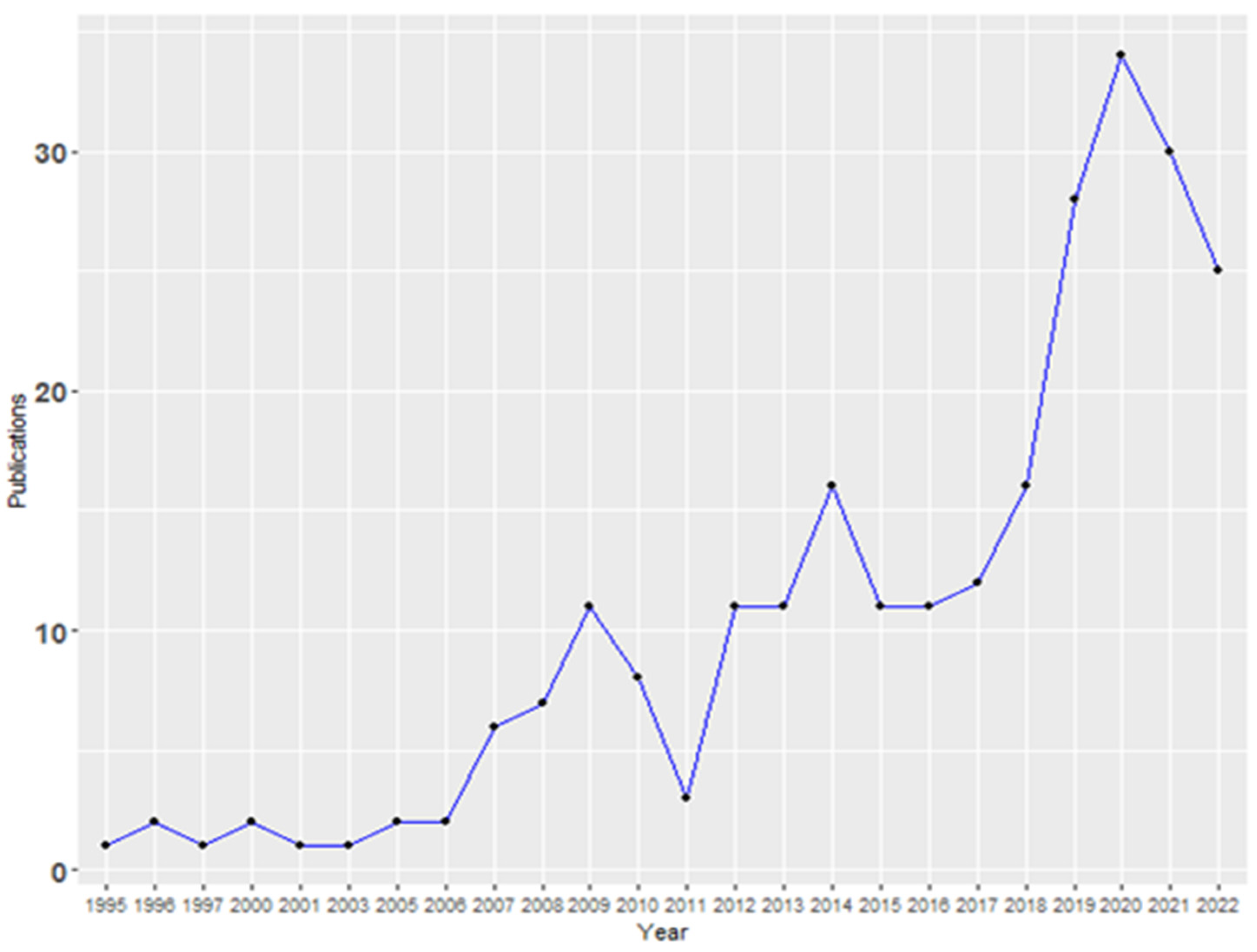
Figure 2.
Article selection process.
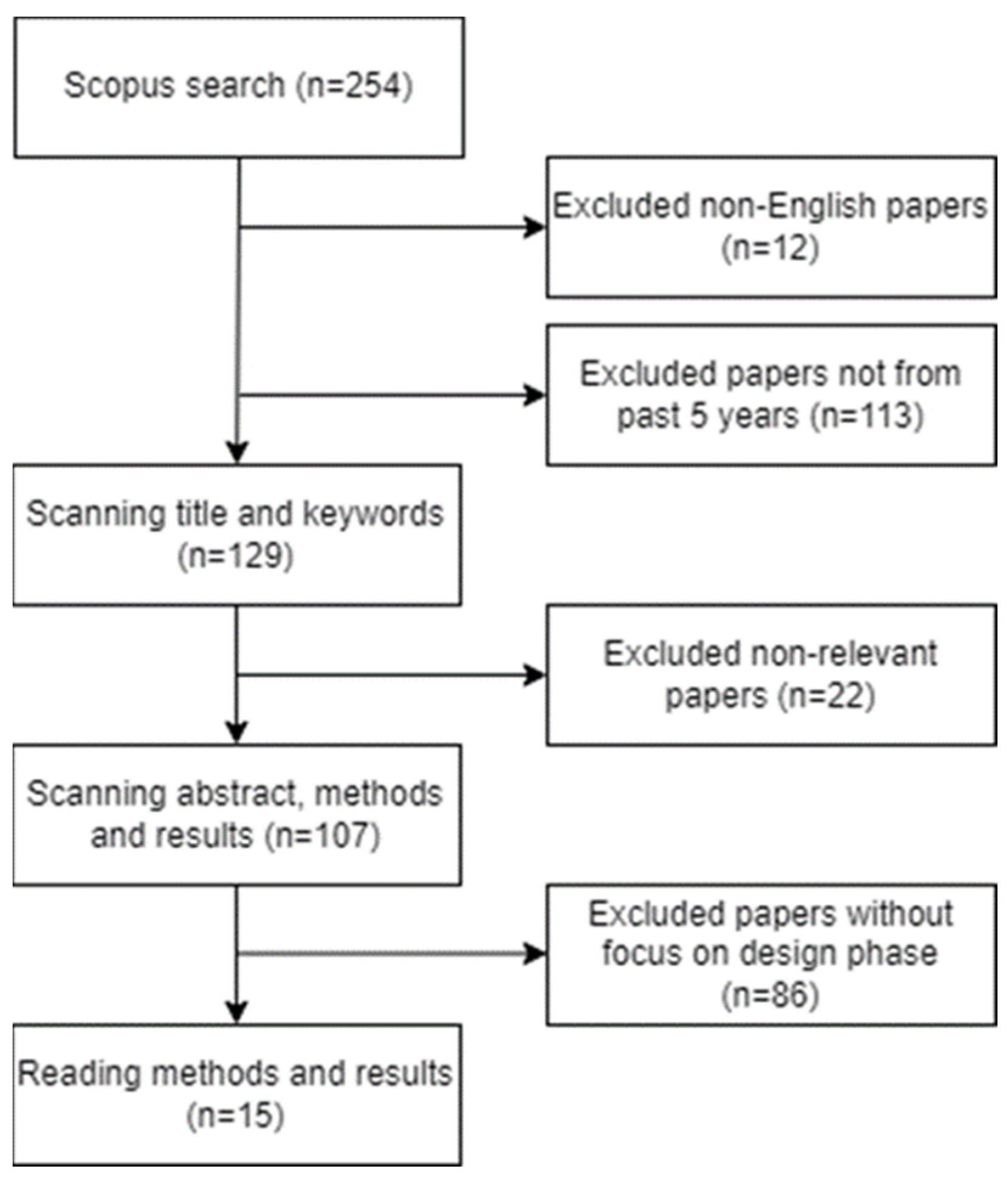
Figure 3.
Radial histogram keyword frequency.
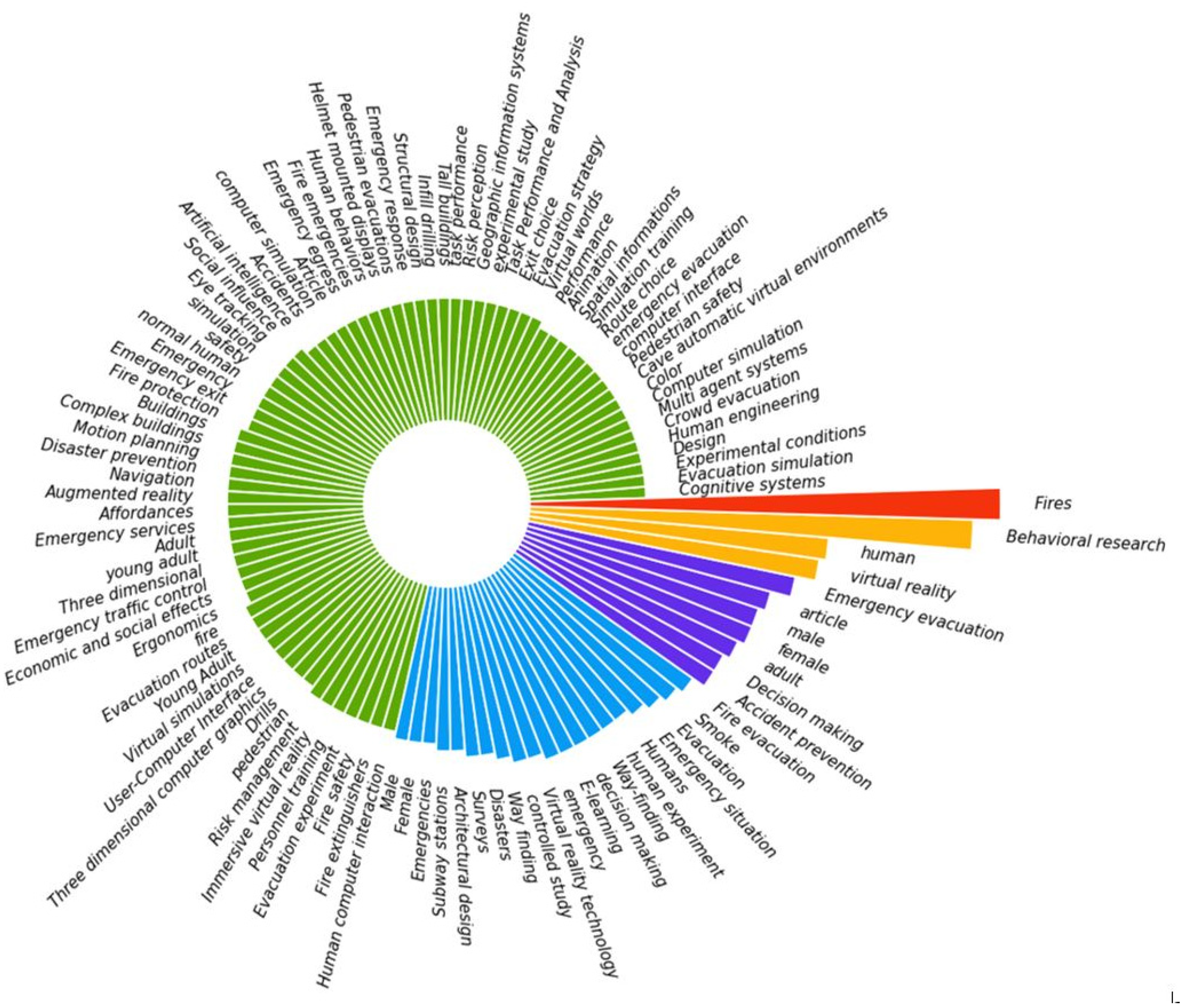
Figure 4.
Roadmap for VR development.

Table 1.
Related literature reviews.
| Paper | Subject | Keywords | Papers Reviewed | Author’s Categories |
|---|---|---|---|---|
| Parikh et al. (2022) [18] | VR for Digital Twins | (‘virtual reality’ OR ‘VR’) AND (‘digital twin’ OR ‘virtual twin’) | 30 | (1) Application fields, (2) use cases, (3) technologies and interaction forms and (4) challenges and issues |
| Zhu et al. (2020) [20] | XR for Emergency Management in Built Environment | (‘building’, ‘communit*’, ‘urban’, ‘indoor’ and ‘city’) AND (‘virtual reality’, ‘augmented reality’, ‘mixed reality’ and ‘VR’) AND (‘emergency’, ‘emergencies’, ‘danger’, ‘hazard’ and ‘disaster’) | 84 | Use case: (1) Pre-emergency preparedness with (a) hazard recognition and prevention and (b) safety training, (2) responses during emergency with (c) human evacuation and (d) search and rescue and (3) post-emergency recovery with (e) damage detection and (f) building reconstruction Human–computer interaction: (1) Technology with (a) hardware and (b) software and (2) application of the tool with (a) visualization and (b) bidirectional interaction |
| Çöltekin et al. (2020) [1] | XR in Spatial Sciences | - | 150 | (1) Technology, (2) design and (3) human factors, which are all further divided into (a) state of the art and trends, (b) research priorities and (c) examples |
| Wolf et al. (2020) [21] | Mixed Reality for Public Participation in Urban Planning | - | 8 | Use case: (1) Communicating plans, (2) finding designs for public spaces, (3) conceptualizing the build environment, (4) defining architectural design and (5) visualizing and experiencing invisible factors Benefits of VR: (1) Enhancement of understandability, (2) process enhancements, (3) interactivity and (4) traceability |
| Feng et al. (2022) [22] | VR Serious Games for Evacuation Training and Research | (‘virtual reality’ OR ‘virtual environment’ OR ‘virtual simulation’ OR vr AND evacuation) | 15 | Gaming outcomes and measures: (1) Events divided into (a) tunnel fire, (b) building fire, (c) aviation emergency, (d) spacecraft emergency and (e) building earthquake, (2) outcomes with (f) pedagogical, (g) behavioral and (h) pedagogical and Behavioral and (3) learning measures divided in (i) questionnaire, (j) open-ended interview, (k) paper-based test and (l) logged game data Gaming environment: (1) Teaching method, (2) navigation solution, (3) narrative method, (4) hazard simulation (5) senses stimulation and (6) non-playable characters (NPCs) |
| Jamei et al. (2017) [9] | VR in Planning for Sustainable Smart Cities | - | 43 | Subject: (1) Smart, sustainable cities and VR, (2) development of VR, (3) VR and planning smart cities and (4) VR and real-time simulation Use case potential: (1) Visualizing pedestrian thermal comfort in cities, (2) visualizing smart transportation for a city, (3) data management and (4) visualizing the cognitive behavior of urban dwellers |
Table 2.
Software and hardware overview.
| Paper | 3ds Max | Revit | Blender | AutoCAD | Maya | Unity | Unreal | HTC Vive | KAT VR | Oculus Rift |
|---|---|---|---|---|---|---|---|---|---|---|
| [16] | x | x | x | x | ||||||
| [28] | x | x | x | |||||||
| [29] | x | x | x | x | ||||||
| [30] | x | x | x | |||||||
| [22] | x | x | x | |||||||
| [31] | x | x | x | |||||||
| [26] | x | x | ||||||||
| [32] | x | x | x | x | ||||||
| [33] | x | x | x | |||||||
| [34] | x | x | x | |||||||
| [35] | x | x | ||||||||
| [36] | x | x | ||||||||
| [37] | x | x | x | x | ||||||
| [38] | x | x | x | x | ||||||
| [20] | x | x | x |
Table 3.
Overarching recommendations: Challenges and solution directions.
| Category | Challenges | Solution Directions |
|---|---|---|
| Application design | The 3D coordinate system of the modelling software is often different than the system used in the game engine; Imported objects end up being invisible because they are inverted; Z-fighting phenomenon. | Starting first with the building model construction over assets (e.g., [16]); Attention to the properties a model for a VR application should have (e.g., [26]); Indicators for improving the participants’ perception of distances and depth should be represented; Models’ geometry and spatial data should exactly represent the real environment (including recognizable objects); Ambiance (i.e., correct color schemes) can contribute to creating an optimal model; Include a custom logger script to export the exact location and movement (e.g., [22,38]); FPC is essential for wayfinding; |
| User experience | Optimization requires an iterative process; High rates of polygons or materials and objects negatively affect rendering; Discomfort (e.g., cybersickness) makes the experience less immersive (e.g., [26]); A high movement speed can cause motion sickness and a lower speed can make the experience boring and decrease the participants’ tension [31]. | Optimal frame rate for a smooth VR experience is 90 fps (e.g., [26]); Exclude objects that are not visible from the render by using Occlusion Culling [34]; Set a movement speed of 2.5 m/s [31]; Make use of the swing of the participants’ arms to increase immersion [26,30,35]; Pre-testing should be carried out with real participants (but this does not have to be the full experiment); NPCs caused a higher sense of emergency on their participants [20]; |
| Collecting results | Creating balanced groups to compare different circumstances (e.g., experience level, etc.) [26,29,32,37]; Ethical approval, consent form that needs to be signed that includes an explanation of cybersickness that could potentially occur. | A total of 93 participants on average (mean); Check basic health to make sure they can participate in their VR experiment [20]; Ask for the participant’s experience with the building on which their application is based; Emphasize the importance of ethical aspects, such as announcing when coming close to or touching the participant; Start with training in the VR environment; |
| Evaluating the application | Selection of the questionnaire (e.g., usability, presence or SSQ); Three levels of metrics that are used for evaluating wayfinding behavior: decision-making, task performance and observation behavior | Evaluate by means of multiple methods (e.g., AHP weighting method and fuzzy comprehensive evaluation or a confirmatory factorial analysis); Group answers into categories if possible (e.g., interface and control, experience of the virtual environment and the process of wayfinding [30]); Measure validity by comparing results from the virtual environment to results from real environments. |
Table 4.
Overarching recommendations.
| Category | Description |
|---|---|
| Model(s) | The format of the model should be suitable for the chosen software, and conversion causes a loss of quality; The model should be complete and fully understood before development in the game engine is started; Import and export settings should be noted and used consistently; |
| Game Engine | Both models for the building and other objects in the application should not be unpacked during the development phase; Code for collecting data should be inspired by previous research and be available for future research; Researchers should stick to one scene or create a clear plan for the scene structure beforehand if multiple scenes are necessary; |
| VR | The computer that is going to be used for development should be checked for VR and software compatibility beforehand; The application should be tested with the VR device during the development phase to prevent mistakes that only occur in VR; A single tutorial or guideline should be selected that is definitely not outdated and that is suitable for the software and hardware used. |
Disclaimer/Publisher’s Note: The statements, opinions and data contained in all publications are solely those of the individual author(s) and contributor(s) and not of MDPI and/or the editor(s). MDPI and/or the editor(s) disclaim responsibility for any injury to people or property resulting from any ideas, methods, instructions or products referred to in the content. |
© 2024 by the authors. Licensee MDPI, Basel, Switzerland. This article is an open access article distributed under the terms and conditions of the Creative Commons Attribution (CC BY) license (https://creativecommons.org/licenses/by/4.0/).
Share and Cite
MDPI and ACS Style
Wiltenburg, R.; Mendoza, F.R.; Hurst, W.; Tekinerdogan, B. Virtual Reality for Spatial Planning and Emergency Situations: Challenges and Solution Directions. Appl. Sci. 2024, 14, 3595. https://doi.org/10.3390/app14093595
AMA Style
Wiltenburg R, Mendoza FR, Hurst W, Tekinerdogan B. Virtual Reality for Spatial Planning and Emergency Situations: Challenges and Solution Directions. Applied Sciences. 2024; 14(9):3595. https://doi.org/10.3390/app14093595
Chicago/Turabian StyleWiltenburg, Reinout, Frida Ruiz Mendoza, William Hurst, and Bedir Tekinerdogan. 2024. "Virtual Reality for Spatial Planning and Emergency Situations: Challenges and Solution Directions" Applied Sciences 14, no. 9: 3595. https://doi.org/10.3390/app14093595
Note that from the first issue of 2016, this journal uses article numbers instead of page numbers. See further details here.