Review

Soil Erosion from Agriculture and Mining: A Threat to Tropical Stream Ecosystems

1
River Culture (Fleuve et Patrimoine), Interdisciplinary Research Centre for Cities, Territories, Environment and Society (CNRS UMR CITERES), Université François Rabelais, Parc Grandmont, 37200 Tours, France
2
Department of Biology, Center for Agricultural Research in Suriname (CELOS), Anton de Kom University of Suriname, Leysweg, Paramaribo, Suriname
*
Author to whom correspondence should be addressed.
Agriculture 2013, 3(4), 660-683; https://doi.org/10.3390/agriculture3040660
Submission received: 23 July 2013 / Revised: 7 September 2013 / Accepted: 13 September 2013 / Published: 30 September 2013
(This article belongs to the Special Issue Soil Erosion: A Major Threat to Food Production and the Environment)

Abstract

:
In tropical countries soil erosion is often increased due to high erodibility of geologically old and weathered soils; intensive rainfall; inappropriate soil management; removal of forest vegetation cover; and mining activities. Stream ecosystems draining agricultural or mining areas are often severely impacted by the high loads of eroded material entering the stream channel; increasing turbidity; covering instream habitat and affecting the riparian zone; and thereby modifying habitat and food web structures. The biodiversity is severely threatened by these negative effects as the aquatic and riparian fauna and flora are not adapted to cope with excessive rates of erosion and sedimentation. Eroded material may also be polluted by pesticides or heavy metals that have an aggravating effect on functions and ecosystem services. Loss of superficial material and deepening of erosion gullies impoverish the nutrient and carbon contents of the soils; and lower the water tables; causing a “lose-lose” situation for agricultural productivity and environmental integrity. Several examples show how to interrupt this vicious cycle by integrated catchment management and by combining “green” and “hard” engineering for habitat restoration. In this review; we summarize current findings on this issue from tropical countries with a focus on case studies from Suriname and Brazil.

1. Introduction

Soil erosion caused by human land use is a widely known and intensively studied subject in agronomic sciences [1] and biogeochemistry [2]. The mobilisation and the transport of soil particles primarily causes losses of the fine and less dense particle fractions, including humus particles and clay, both of which are important carriers of soil nutrients and stabilizing agents for the physical properties of soils. The global areas of land area affected by erosion are estimated at 1094 million ha (Mha) by water erosion, of which 751 Mha is severely affected worldwide, and 549 Mha by wind erosion, of which 296 Mha is severely affected [3]. The economic losses by deterioration or complete loss of agricultural surfaces amount to billions of dollars [4].
Much less attention has been paid to the fate of these eroded particles when they have left the managed land. Our mindset is used to associate a brownish colour to the image of a “river”, however, in many to most cases this colour does not derive from natural erosion processes in mountainous areas but rather relates to human activities in the catchment that increase erosion and sediment load in running water systems that drain these impacted areas. Rivers are transport systems, that carry a certain amount of solid substances. The sediment budget depends on the geological source material, e.g., the sediment-rich “white-water” rivers drain the geologically young Andes Mountains whereas clear- and black-water rivers that drain the weathered Precambrian Brazilian and Guiana Shields have a naturally low sediment load (terminology by Sioli [5]). Due to man-made increase of solid inputs into rivers, however, many river systems have to cope with un-natural amounts of solid discharge, especially in their headwater sections, and may become “overloaded” in the literal sense of the word. This overload is caused not only by agricultural erosion. Other human activities, such as mining for mineral resources at the soil surface, forestry, and badly planned road construction and/or drainage projects (both of which are often linked to agricultural activities) also may increase the solid discharge of streams and rivers beyond the natural dimensions. The effects on the biota are complex [6], but currently well recognized as one of the main anthropogenic threats to running water ecosystems in the world [7] including the Tropics [8]. The effects are also quite similar whatever the origin of the sediment overload. This is why this review deals with different aspects of sediment overload in running water systems on aquatic and riparian biota.
In tropical countries, the ecological setting in rivers and streams differs in a certain way from temperate systems [9,10,11]. Predictable spring floods deriving from snow melt, are well known in the temperate zone, but in the Tropics they are restricted to areas in the foothills of high mountains, e.g., in Ecuador [12]. Tropical rainfalls may provoke very short-termed and large changes in the discharge volume; increases up to 16 fold are reported from Latin America [13]. Wide areas in the Tropics have seasonal discharge patterns including extensive rainy periods once or twice a year and dry seasons between them. Each subsequent rainfall event over a rainy season increases the discharge. Consequently, the pulses of sediment entering the streams from erosion of gullies allow only very short intervals (if any) for the stream organisms to recover [14,15], and the accumulating effects of repeated single events are much stronger than their sum. Even during the dry season when lateral erosion gullies cease to deliver sediments and the stream discharge is reduced, the sand deposits that have covered the riparian zone during the rainy season gradually fall back into the stream channel due to bank slumping of the instable sediment deposits, prolonging the effects.
Many factors that enter into the Universal Soil Loss Equation result in non-linear increases in soil erosion in the Tropics [16]. For example, owing to the high erodibility of old soils in the Tropics (compared with the young ones of glaciated temperate areas), intense rainfall events with high energy impacts can be particularly erosive. The still widespread occurrence of inadequate soil management techniques may also increase erosion processes in the Tropics relative to the temperate zones. Subsurface drainage, a common source of fine sediments in temperate streams, is (still?) less important in tropical agriculture. Moreover, while in temperate areas the potential for agriculturally useable areas is asymptotically reaching the limits of growth, many countries still have a large potential of useable areas, and the land use change from native vegetation into agricultural and pasture areas is most intensive in the Tropics [17]. Generally, erosion problems occur during the first years of cultivation rather than during routine management.
The erosion impacts of soil surface mining are the same as in agriculture, i.e., the additional sediments reach the stream via small lateral channels. The origin and type of sediments depend on the type of erosion. Gully erosion and superficial mining using water jets often mobilize the upper 1–10 m, which are mostly inorganic soils, whereas superficial sheet erosion in agricultural areas produces a larger proportion of humic substances, other organic substances and fine particles. However, there is a big difference in the governance of mining. In tropical countries, large mines of transnational companies have their environmental problems, including erosion from mine-waste dumps and roads, but they usually keep up with (international and local) environmental standards/legislation and the mines are mostly easily accessible and easily controlled. However, artisanal miners often ignore regulation about decantation of sediments mobilized for mining, if legislation exists at all, and law enforcement is hampered by the large number of remote and small-scale mining sites. The current gold rush in tropical South America was triggered in 1980 by the discovery of a 90,000 kg gold deposit in Serra Pelada, Amazonia, Brazil, and, in 1989, the number of individual miners in Amazonia was already estimated as high as one million [18]. Most of these miners are typically poor people driven by survival and with no subsistence alternatives [18,19]. The 400% increase of the price of gold over the last decade has further stimulated artisanal gold mining in the Amazon [20]. The miners are very mobile and illegally exploit secondary, alluvial surface gold deposits in small-scale mines in (former) stream valleys or they are involved in medium to large scale dredging operations on large rivers. They are extremely difficult to control and also wreak havoc with streams in nature reserves, even when these reserves are small and accessible (e.g., Brownsberg Park in Suriname) and thus theoretically easy to patrol. When easily extractable ores are depleted or legislation and law enforcement make mining too difficult they migrate to other regions and often cross borders into neighbouring countries. Thus the larger portion of the estimated 35,000 artisanal miners in Suriname is illegal immigrants from Brazil [18]. The mining method of hydraulic extraction of soil with high pressure water jets is basically artificial erosion at a very high rate. At the mine site, settling ponds that could prevent sediments from entering streams are not constructed and the riparian forest that could trap eroded sediments is removed. This results in a consortium of individual sources of increased sediment loads, which accumulate along the river. Thus the additive discharge of numerous “muddy” tributaries with gold mining in their catchments can even affect conditions in large rivers: for example on 5 February 2012 an unusually low Secchi disc transparency of 5–10 cm was measured during low flow conditions in the large Marowijne River in Suriname (catchment 68,700 km2, discharge at outfall 1785 m3 s−1, pre-mining sediment discharge 18.9 ton year−1 km−2), a clear-water river draining the Guiana Shield with a natural transparency of 100–200 cm (JM pers. observations). Mercury that is used by the miners to extract gold enters the stream and aquatic food web [21], is transported downstream with the suspended sediment [22], and continues to affect the ecosystem and human health for a long time after mining activities have ceased [18].

2. Results and Discussion

In this review, we focus on describing the entry paths of eroded particles into the streams and rivers and their effects on the aquatic and riparian flora and fauna, and discuss prevention strategies in tropical countries.

2.1. Entry Paths of Eroded Particles into the Streams and Rivers

Once mobilized, eroded particles follow the hydraulic gradients and end up in the hydrographical network of rivers and streams. The origin of these particles can be manifold. Here, we focus on agricultural and mining processes.

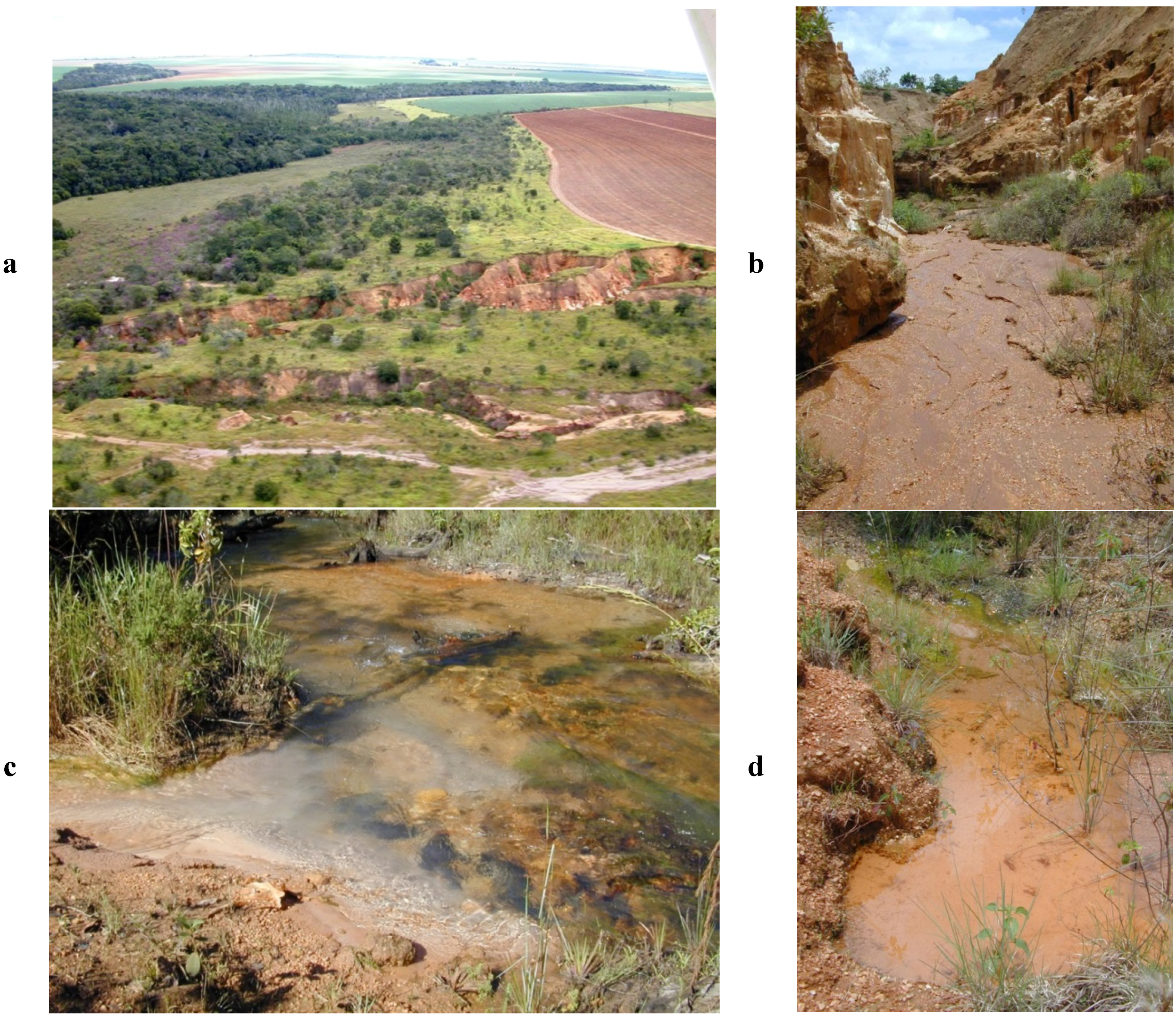
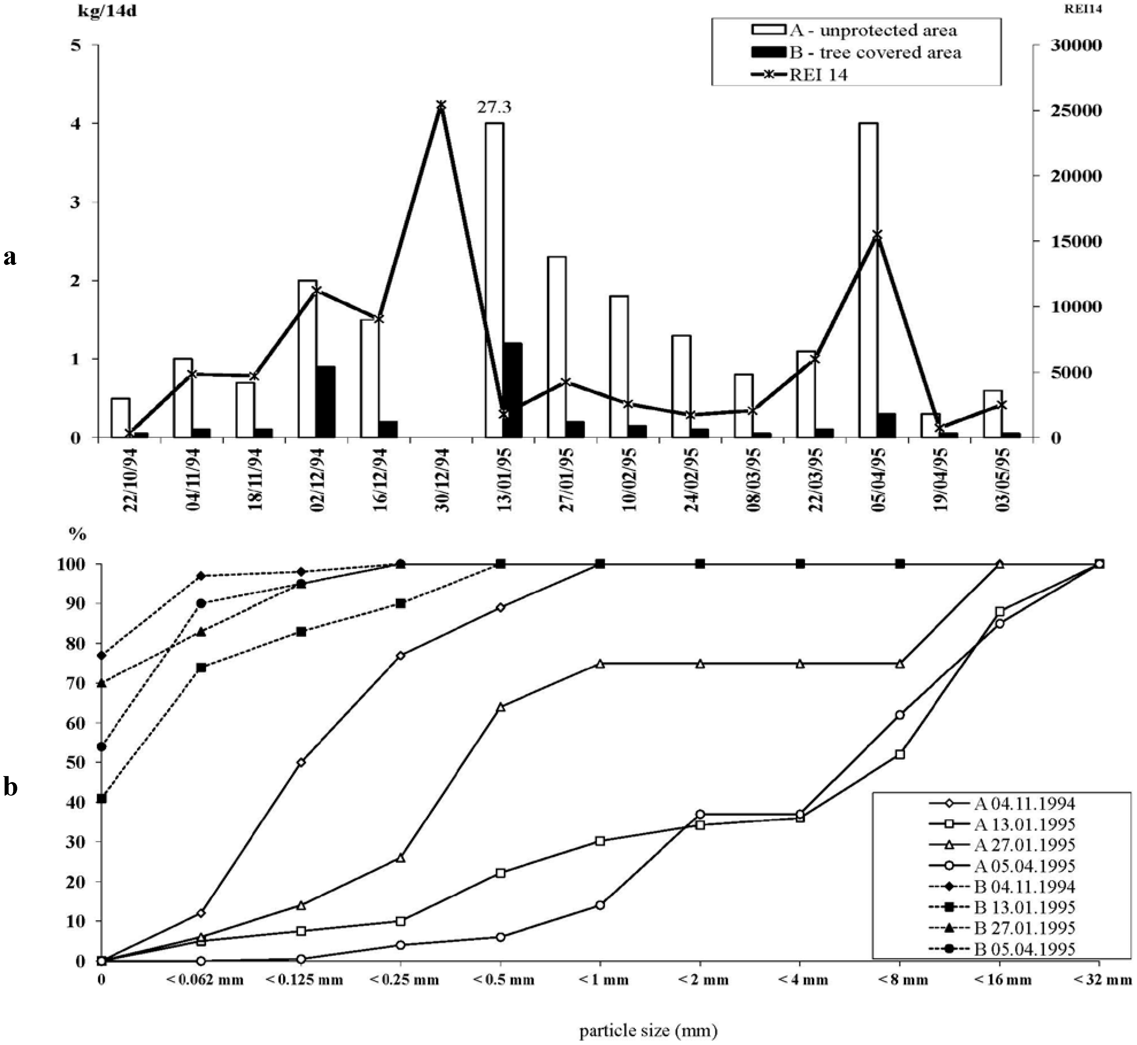
2.1.1. Agriculturally Caused Erosion, Including Drainage and Earth Road Construction

As a number of detailed studies on agricultural soil losses are published in this volume, we will only give a short summary of the processes that are relevant for the erosion process as such. We focus primarily on the transfer of eroded soil material into the streams and rivers, with a bias towards personal observations and studies in the Brazilian Cerrado savannah landscape. Most of these features, however, can be found in wide tropical areas.
The constant pressure for increased productivity, driven by growing market prices, leads to an intensification of agricultural use, with a range of negative effects for the ecological integrity of the landscape, such as erosion. The reformulation of the Brazilian Forest Code in December 2012 has strongly reduced the law enforcement against farmers who did not provide sufficient protected areas, and it also has allowed the use of permanently protected areas mentioned above, which may cause a step by step size reduction of these areas below the critical minimum size. In the State of Mato Grosso alone, the renewed Forest Code exempts 8 million hectares from reforestation (as it would have been necessary according to the previous version of the law), while another 6 million hectares will have to be reforested even now. Reinforcement for permanently protected areas will be exempted on 400,000 ha, while 500,000 ha still have to be recuperated [23]. The general recommendation by the advisory teams of the governmental agricultural consultancies is to use sandier soils for pasture, and clayey soils for agriculture. Pasture is also the prevailing land use for recently deforested areas along the agricultural expansion frontier in Southern Amazonia [17]. Very often cattle are allowed to move freely through very large areas. Drinking water is rarely provided for the animals, so that cattle compact soils on their trails in the riparian zone when looking for water. These cattle tracks are very often perpendicular to the contour lines; thus they are prime sites for initializing gully erosion. Specific habitats that are permanently protected by the Brazilian Forest Code [24], such as the riparian belt of 30–200 m, swamp forests, marshy campo wetlands, and steep hills, often become cut by cattle tracks [25]. All of these habitats are specifically sensitive to erosion. However, even in the more developed cattle ranches that keep the animals out of the sensitive riparian zone, erosion also occurs due to inadequate choice of exotic fodder species. Failure of seeding, or occurrence of pests (e.g., leaf-cutter ants) often results in bare soils sensitive to erosion. Several species of fodder plants grow in tufts that leave open space between them, which are preferred cattle tracks in the pasture landscape that serve as acceleration pathways for surface runoff. Lastly, we learned during field interviews that the degree of professional training and the general attitude of ranchers and farmers considering soil protection may be quite different. While cash crop farmers very often have a degree in agronomy, and have a very careful attitude towards soil conservation, many ranchers dispose over very large areas, where the occurrence of erosion is a minor problem, and erosion gullies only become fenced off when they turn into mortal traps for cattle.
Due to the use sequence “deforestation → cattle ranching → cash crops”, we find in the Brazilian agricultural frontier region that the farmers planting cash crops often inherited erosion problems from the former owners (i.e., Harding’s “ghost of land use past” [26]). To mitigate the problems, contour ploughing, development of elevated contour lines, specific care for road construction and road drainage was undertaken. In the past 15 years, the percentage of direct planting (without or with minimal ploughing) has had considerable positive effects on soil quality [27] but a still unknown effect is the large-scale use of pesticides such as “roundup” that are used to kill off the interim plantation between the cash crops and to provide bare soil without tilling. Still, the erosion problem locally persists, especially if gullies reach the water table and continue growing even during the dry season in dendritic patterns (so-called “voçorocas” in Brazil).
An early study of erosion problems during the phase of most intensive land use change in Mato Grosso [28] found that most erosion features formed during the construction of earth roads in agricultural areas rather than during agricultural use itself. Earth roads allow accumulation and acceleration of surface water, which have an enormous destructive potential. In the long-term observation site near Jaciara, Brazil (16°02′30′′ S, 54°59′45′′ W), an erosion gully developed during a single rain event in ca. 1984 (Figure 1a, foreground) due to an earth road perpendicular to the contour lines. The farmers built a new parallel road, which caused the development of another gully (Figure 1a, middle ground), the ecological effects of which have been intensively studied [14,15,25,29,30]. A third parallel erosion gully had developed by 1994 due to cattle trampling (Figure 1a, middle ground). The gullies in agricultural areas of the Cerrado may be several kilometres long and as deep as 15 meters. They drain water from the surroundings (Figure 1 b). At its mouth the gully deposits large amounts of sediments during the rainy season, which are remobilized throughout the year, even during the dry season (Figure 1c). Two Wishmeier plots on deposits of the first gully from 1984 show how much sediment becomes mobilized, and that vegetation cover has a double impact on reducing the total amount of sediments and of keeping the average grain size of remobilized sediments small (Figure 2 a,b). After a while, the gully itself develops stream-like characteristics (Figure 1d), however the successions of the animal and plant communities remain in the early pioneer stages, as rainy season discharges destroy biological surfaces and “reset” the system [14]. In Suriname, similar >2 m deep erosion gullies also developed after heavy rains on earth roads in savannah vegetation; water turtles (Rhinoclemys punctularia) have been collected in these erosion gullies (JM pers. observations). DellaSala et al. [31] have pointed out the importance of roadless areas and the relatively intact ecosystems they maintain for the conservation of threatened freshwater biodiversity and ecosystem services to humans.
Figure 1. (a) Aerial view of a typical erosion gully in the Cerrado of Brazil. On the right, soy bean plantation showing bare soils after harvest, on the left, riparian vegetation surrounding a stream. In the foreground, an earth road and two erosion gullies of different age. The erosion gullies breach the riparian vegetation (capture date of photographs July 1995); (b) Active erosion gully in Figure (a). Deep lateral piping hollows drain groundwater from the surroundings, which flows off through the channel even during the dry season; (c) Stream receiving sediment from the active erosion gully in Figure (b) during the dry season. The gully delivers up to 60 metric tons of sediment per day during the rainy season,; (d) Pioneer vegetation developing on the bottom of the erosion gully in Figure 1c during the dry season. © Karl M. Wantzen.
Agriculture 03 00660 g001
Basically, every land owner is responsible for creating zones where this water can be captured and allowed to percolate, but the reality shows that most owners are mainly interested in getting rid of the problem by constructing water collecting channels, and sending the water to a lower-lying neighbour, resulting in a cascading increase in quantity and velocity of surface water. Eventually, streams and tributary gullies flowing into them are used as the sewers in the farmscape; thus the problem for the farmer has been solved, but the problems in the streams are just beginning.
Figure 2. Mobilization of sediment on Wishmeier-plots (2 × 2 m) in the riparian zone of the stream near the mouth of the erosion gully shown in Figure 1c. (a) Amount of mobilised sediment (kg per 14day, bars, left axis, a maximum value of 27.3 kg was found on 13.1.1995 for a 4-week interval), REI 14 (RainEventIndex) was calculated as the sum of squares of the rainfall of the 14 days prior to measurement (line, right axis) (b) Granulometry of mobilised sediments on Wishmeier-plots from an unprotected site (A) and from a site covered by tree vegetation. Data from Karl M. Wantzen [29].
Agriculture 03 00660 g002

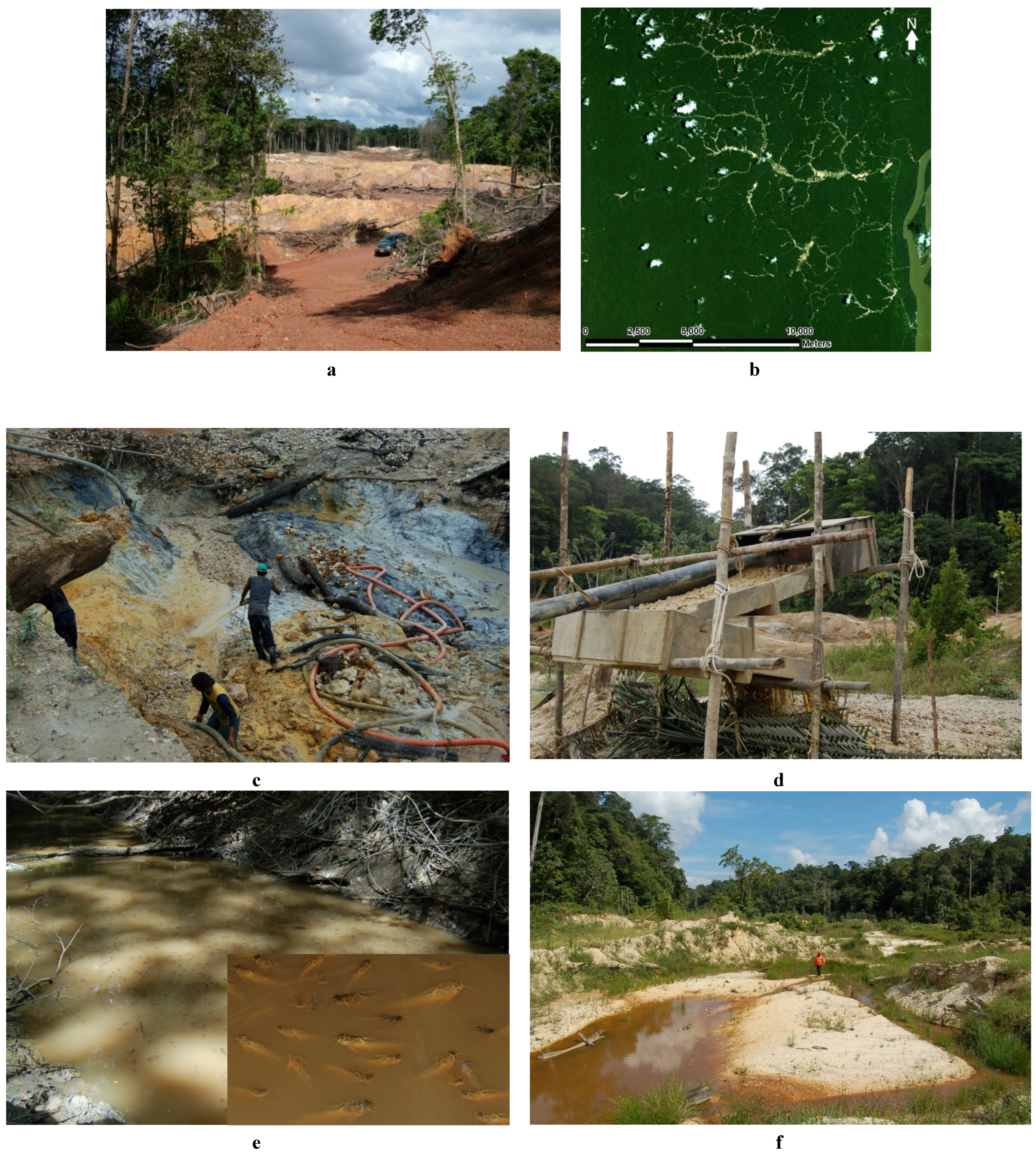
2.1.2. Erosion from Artisanal, Small-Scale Gold Mining Activities

Artisanal gold miners extract gold from easily accessible and exploitable, superficial, placer deposits in stream valleys using simple cheap technologies and then abandon the site when the reserves are depleted. Although “classical” geological exploration is typically not conducted, the trial-and-error discovery method is mostly restricted to areas with known gold-bearing geological formations, (e.g., the Greenstone Belt in eastern Suriname as opposed to western Suriname where primary gold ores do not occur and gold miners are absent). Erosion and siltation of streams are caused by both the method of gold extraction and the removal of the riparian forest along the stream. A mining site is prepared by first removing the riparian forest (Figure 3a,b) which leaves an approximately 200 m wide strip of bare soil along the stream exposed to erosion after heavy rain showers. Peterson and Heemskerk [32] estimated that 2300 km2 of forest in Suriname would be cleared by artisanal miners in 2010; this may be a small fraction of the total area of Suriname rain forest (149,800 km2) but the forest cleared by gold miners is all riparian forest (Figure 3b) and recovery is slow [32]. A recent estimate of mining related deforestation in Suriname based on Landsat images shows an increase in cleared forest from 85 km2 in 2000 to 280 km2 in 2008 [33]. Gold is mined with high-pressure water jets that remove the topsoil and “fluidize” the gold-bearing layer of sand and clay water (Figure 3c) followed by gravity separation of the heavy fraction of the slurry in a sluice box (Figure 3d) and discharge of the superfluous lighter sediments into old mine pits, adjacent to the forest or the stream. The heavy, gold-bearing fraction is amalgamated with mercury and the Au-Hg amalgamate is then separated from the undesirable mineral portion by panning, often at the stream margin. Finally the gold is recovered from the amalgamate by burning in simple pans which removes most of the volatile Hg (with Hg lost to the atmosphere and then after condensation deposited in nearby terrestrial and aquatic ecosystems). The sediment discharge of a mining-impacted stream in Suriname was estimated at 310 tonnes year km2 (of which 95.6% was produced by the 2.5 km2 mine site) as compared to a sediment discharge of 13 tonnes year km2 in an undisturbed neighbouring stream (Table 1).
A bird’s eye view of an active gold mining site shows a stream valley cleared from forest and with the stream itself replaced by a series of water-filled mine pits with colours ranging from bright green (algae) to blue to light brown. Downstream from the mining site the stream is still covered by the closed forest canopy as in a pristine catchment, but when studied closely the diversity of instream habitat and fish assemblage (Figure 3e and below) are low when compared to a stream in an undisturbed catchment (Table 1; [34]). When the gold deposits are depleted and miners migrate to another area they leave behind a legacy of environmental problems. Forest recovery following mining is slow and qualitatively inferior compared to regeneration following other land uses: large parts of mined areas remain bare ground, grass, and pits with standing water even four years after the miners have left the site (Figure 3f). Fine sediments contaminated with mercury are present at the former mine site (on land and in water-filled mine pits) and downstream of the site in the stream.
Figure 3. Artisanal gold mining, soil erosion and stream sedimentation in Suriname; (a) In 2005, the riparian forest was cleared at a recently developed gold mining site along Maykabuka Creek, Gros Rosebel Area (05°04′45′′N, 55°16′9′′W), In 2001, the then pristine Maykabuka catchment still had the forest canopy closing over the stream and the site in the photograph was used as a control in a 1994–2001 study of the effects of gold mining related erosion on instream habitat and fish community [34], (capture date of photograph 8 December 2006); (b) Satellite image showing extensive clearance of riparian forest associated with small-scale gold mining in the catchments of the Merian (05°06′ N, 54°31′ W) and Tumatu rainforest streams, Marowijne River Basin, Suriname, September 2010, Source Quickbird; (c) High pressure water is used to remove the topsoil and then the gold-bearing layer of sand and clay, (capture date photograph of 7 May 2008); (d) In a sluice box heavy particles and gold are gravity separated from the superfluous lighter particles in the slurry which then are discharged into an abandoned mining pit in the adjacent forest or stream, (capture date of photograph 7 May 2008); (e) Downstream a mining site in the Gros Rosebel Area, a shallow dry-season pool in a turbid rainforest stream with intact riparian forest and closed canopy cover (4°30′ N, 55°20′ W) has low dissolved oxygen (1.3 mg/L) and an unusually low fish diversity virtually monopolized by the auchenipterid catfish Trachelyopterus galeatus, (capture date of photograph 5 November 2008); (f) An abandoned mine site in the Merian Creek catchment (05°06′44′′ N, 54°31′16′′ W) shows slow riparian forest regeneration, abundant growth of grasses and a shallow, turbid, sunlit stream, (capture date of photograph 26 November 2011). ©Jan H. Mol.
Agriculture 03 00660 g003

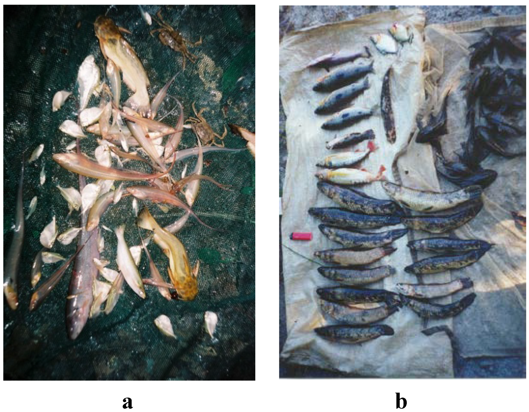
2.2. Effects of Increased Sediment Load on Habitats and Biota in and Near Streams

Sediment, derived from soil erosion from agricultural sites or from surface mining entering a stream in large quantities, changes many environmental conditions at the same time.

2.2.1. Effects on Stream Habitat Structures

Surfaces of natural and artificial substrates protruding into the current become scoured by the suspended sediment that acts like a blaster used for abrasion of unwanted graffiti. Consequently, epilithic algae covers (biofilms) are brushed off. It could be shown experimentally that single rain events can diminish these biotic layers drastically and therefore it was concluded that scouring effects limit food for grazing organisms, e.g., macroinvertebrates [30] and loricariid catfish [35].
The particles that remain in suspension increase the turbidity of the water, reduce light transmission [36], and thus affect the aquatic food web, both from the bottom up through reduced photosynthesis and top-down by limiting visual foraging efficiency of many fish [37]. The population of visually oriented animals decreases in streams impacted by anthropogenic sediment [34]. Many of these are predators, which play an important role in the structure of the entire biotic community (i.e., top-down effects). Plants depend on light. Other than temperate streams that are mostly driven by allochtonous organic leaf litter falling from the riparian trees, tropical streams have an additional food source coming from autochtonous algal production [38]. Even though there are limited light spots or lit periods on the stream bottom, these are sufficiently strong to support photosynthesis. Stable isotope studies have shown that in many tropical streams, algal production is very important [39,40]. Increased turbidity of these naturally clear streams therefore changes the baseline of the entire food web (i.e., bottom-up effects).
Lastly, deposited sediment covers habitats and food sources. Sediment settles in low-current zones of the streams (e.g., pools), which are important deposition zones for organic matter. Woody debris, leaf litter and fine organic particles which represent an important source of food or shelter for most aquatic animals become completely covered by sediment [34]. Apart from being unapproachable by animals, the sediment-covered organic materials start decomposing in an anaerobic pattern, which has severe negative impacts on water quality, such as depletion of dissolved oxygen and, in mining areas, methylation of mercury (which allows for accumulation and biomagnification of mercury via the food chain). Even if the riparian vegetation still appears to be nearly natural, the increased solid discharge causes the loss of most of the biodiversity in the stream channel (e.g., downstream of a mining site [34]).

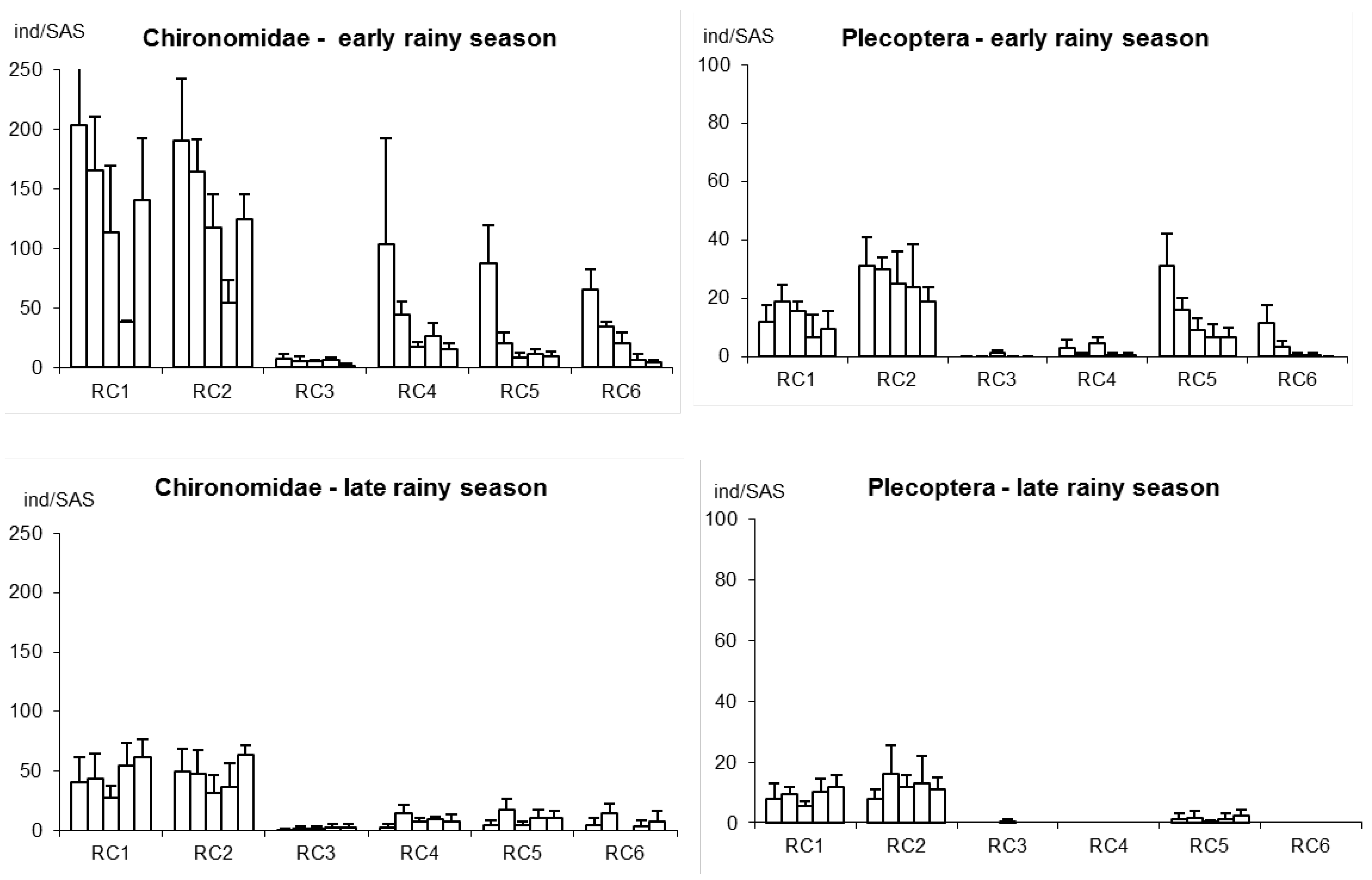
2.2.2. Effects on Stream Plants and Animals

As shown above, the physical structure of habitats and food sources become more limited or is destroyed. Apart from these indirect impacts, aquatic biota also suffer direct impacts from excessive loads of suspended or bottom-transported sediments. The mechanisms by which and where the suspended solids interfere with the aquatic organisms are generally known [6,41,42].
Aquatic macrophytes often colonize low-energy habitats, where sediment settles on their leaves and blocks photosynthesis. Increasingly thick sediment layers cause anoxia and reduce the possibility of nutrient uptake by the roots. The branched structure of macrophytes makes them ideal sediment traps; indeed, sediment accrual is a growth strategy of many water plants [43]. When sediment loads increase, however, this strategy causes fast burial of the macrophytes [44]. Water plants and roots from terrestrial plants protruding into the high current zone of the stream bed become sheared off. This has especially severe effects on the entire ecosystem whenever and wherever these plants have an important structuring role by providing habitat for most of the other biota. In tropical rivers, plants of the family Podostemacea live in the shallow, fast flowing water of rapids where they are estimated to harbour up to 50% of the animal and plant biomass on just 1% of the stream bed [45]. Many fish that dwell in rapids, feed on invertebrates living in the Podostemacea vegetation or on the plants themselves [46] and find shelter from predators and from the river current between the submerged leaves. Odinetz Collart et al. [47] suggest that the Podostemacea vegetation is sensitive to smothering by deposited sediment from gold mining.
Filtering organs, gills and sensitive body surfaces of animals become clogged or abraded. As most aquatic animals breathe either via gills or sensitive membranes on their body surface, this effect is deleterious for the entire fauna. Siltation quickly eradicates large mussels, as these have a limited potential to move away from the impact, and are especially sensitive to clogging of their filter-feeding and breathing organs [48]. In a survey of aquatic macroinvertebrates above and below the confluence of a stream with an erosion gully, practically all taxonomic groups showed dramatic decreases with siltation impacts, with the exception of animals that are able to dig in sand and/or to breathe at the water surface [14]. Experiments with stoneflies (genus Anacroneuria) in artificial flumes have shown that drift was significantly increased by increasing sand concentrations (MANOVA, p < 0.0001, n = 150); [29]. Benthic invertebrates perceive the increased sand load in the water within less than a second and start to search for downstream habitats, which may, however, already be sand-covered. A study trying to establish a bio-indicator system for measuring the degree of severity of sand deposits using standardized artificial substrates [49] revealed that practically all taxonomic groups of invertebrates suffer from siltation impacts alike. There is a gradation of organisms that prefer substrata with solid surfaces such as stoneflies (Plecoptera), which are the most severely reduced, compared to organisms that can dig into softer substrates such as non-biting chironomid midges, which may recover more quickly from the siltation impact (Figure 4). The life-cycle length and the reproductive strategy of the organisms are very important in determining their sensitivity to changes in their physical habitat by processes like siltation. The longer-lived stoneflies became completely eradicated from sites downstream from an erosion gully, while the short-lived chironomids (life cycle length of less than three weeks) could still colonize the artificial substrates in our study (see [14] for a detailed analysis).
Figure 4. Accumulating effects on the abundance aquatic insects (Chironomidae and Plecoptera, individuals per standardised artificial substrate, averages plus standard deviation) from the beginning (22 October 1994–16 December 1994) to the late (8 March 1995–3 May 1995) rainy season (Each pillar represents a 14 day interval) in a Cerrado stream. RC1, RC2: reference sites above the confluence with the erosion gully (RC3), RC4-RC6: impact sites with growing distance below the confluence. Data from Karl M. Wantzen [29], see [14,49] for site and method description.
Agriculture 03 00660 g004
Impacts from increased anthropogenic loads of suspended and deposited sediment on fish are best studied in temperate salmonid fish from the Northern Hemisphere [50]. The effects of sediment on fish are complex and often include cumulative or synergistic effects with other stressors that are difficult to capture in laboratory studies. Effects can be lethal (individual fish are killed) or sublethal (e.g., tissue damage or alteration of physiology resulting in reduced growth), or behavioural . The magnitude of the impact depends on the concentration of suspended sediment, type of sediment (particle size, angularity), duration of exposure (sort pulse vs. chronic), natural background levels (e.g., high flow conditions vs. low-flow conditions, white-water vs. clear-water rivers, position in the river continuum as in headwaters vs. estuary), species (clear-water species, like salmonids, that are not normally exposed to high sediment levels are most sensitive) and life stage (early life stages such as eggs and larvae are often most sensitive) [50,51]. Turbidity reduces plant biomass and food availability, as well as the visibility of pelagic food, and also reduces predation risk from visually-oriented piscivores and fishing birds; particles clog gillrakers and gill filaments and reduces benthic food availability [52]. Salmonids are known to avoid turbid water [50] and thus anthropogenically enhanced suspended sediment concentrations can affect their upriver spawning migrations and headwater ecosystems [53]; such information is currently lacking for tropical migratory fish species [54]. The deposited sediment covers habitat structures (leaf litter, submerged root masses, woody debris, gravel beds, macrophyte stands) that fish use for shelter or reproduction ([34]; Table 1). The interstitial pore space of coarser (pebble) sediment in mountainous regions is a very important habitat for early life stages of fish (eggs, larvae) that can be lost by siltation. Many fish of temperate zones such as salmon and lampreys spend their egg and early life phases in this pore space. Siltation causes clogging and reduction of habitat quality (e.g., reduced flow, reduced oxygen concentration, etc.), thus preventing fry emergence or making the gravel bed uninhabitable [55]. Human-induced change in optic conditions in water with increased suspended sediment degrades the sensory environment of fish and thus negatively affects visual communication [56], important in schooling [57], territoriality, and courtship [58]. Evolutionary consequences of high turbidity (associated with eutrophication) were revealed in Lake Victoria cichlids showing decreased intensity in male colour, decreased colour-mediated sexual selection, and a decreased number of coexisting colour morphs (i.e., diversity) in turbid water [59]. Both richness and diversity of fish assemblages in Brazilian Cerrado streams were negatively influenced by siltation impacts caused by agriculture [60]. In the stream systems studied by Wantzen [14], several headwaters originally harbouring a rich fish fauna became entirely fishless as a consequence of siltation. In Suriname, two super-endemic catfish species (distribution restricted to a single mountain creek) are threatened with extinction by on-going gold mining and a proposed bauxite mining project in Nassau Mountains [61]. Mol and Ouboter [34] studied the instream habitat and fish assemblage of a small lowland rainforest stream in Suriname in a reach immediately downstream a gold mining site (Table 1). Whereas elevated turbidity associated with short pulses of sediment delivery to streams (e.g., after heavy rains flush sediments from earth roads in a tributary) apparently can offer temporary protection to prey fishes from visually-oriented piscivores (J. Mol pers. observations), the mining-impacted stream had chronically (1994–2001) high suspended sediment concentrations, high turbidity, low Secchi disc visibility, a thick layer of fine sediment covering bottom substrate, and low substrate diversity compared with an undisturbed control stream in a neighbouring catchment (Table 1). The fish of the turbid, mining-impacted stream were silvery or unpigmented as compared to fish from an undisturbed stream (Figure 5). Although the mining-impacted stream was slightly larger than the pristine control stream it had a lower number of fish species and lower fish diversity compared to the undisturbed stream (Table 1). The mining impacted stream had few visually-orienting fishes such as cichlids, callichthyid catfish (mainly Corydoras spp.) and eryrthrinid piscivores (mainly Hoplias spp.), but abundant fish that communicate and feed with olfactory and tactile (auchenipterid catfish), electric (gymnotiform knife fish) and lateral line (Gasteropelecidae or hatchet fish) senses (Table 1). The mining-impacted stream also had few juvenile fish and few large food fish (erythrinids, cichlids) compared to the pristine stream (Table 1). Lujan et al. [62] also found large, economically important fish (Pimelodidae and Serrasalmidae) absent from a mining impacted river in the foothills of the Andes Mountains. There are very few studies on effects of mining on tropical fish outside the Neotropics, but Moyle & Leidy [63] suggest that “in Sri Lanka, sedimentation from logging practices on steep rain-forest slopes and streamside mining has been a major contributor to the decline of the endemic fishes”.
Table 1. Downstream impact of gold-mining related erosion on instream habitat and fish community structure of a small rainforest stream in Suriname in the period 1994–2001, data from Mol and Ouboter [34].
Undisturbed Stream
Maykabuka Creek
Mining-Impacted Stream
Mamanari Creek
Monthly flow (m3 s−1)0.54–1.650.92–3.92
Riparian rain forestUndisturbedUndisturbed
Total suspended solids (mg L−1)19.0–28.9318–2469
Turbidity (NTU)28.2–31.1424–2874
Secchi disc visibility (cm)>50<10
Sediment yield (tonnes year km2)13310 (of which 95.6% produced by the gold mine)
Thickness of layer of fine sediment on the streambed (cm)012.8 (runs)–33.2 (pools) (maximum 57 cm)
Substrate diversity (Shannon-Wiener index)1.570.70
Number of fish species6856
Fish diversity (Shannon-Wiener index)3.19–3.392.60–2.70
Erythrinidae (% of total number of fishes caught)3.480.41
Gasteropelecidae (%)4.8118.61
Gymnotiformes (%)3.5412.62
Auchenipteridae (%)1.203.33
Callichthyidae (%)14.650.62
Cichlidae (%)5.980.58
Juvenile fishes (%)57.314.1
Food fishes (% of total fish biomass)33.213.4
Figure 5. Impact of small-scale gold mining on fish communities of rainforest streams as revealed by fish collections from two small rainforest streams in Suriname; (a) Surface feeding hatchet fishes and nocturnal electric knife fishes and catfishes dominate the catch in a mining-impacted stream; note the unpigmented or silvery colours of the fishes; (b) Large diurnal piscivores (Hoplias spp.) and brightly coloured fishes dominate the catch in an undisturbed neighbouring stream. See Mol and Ouboter [34] for details. ©Jan H. Mol (capture date of photographs April 2001).
Agriculture 03 00660 g005

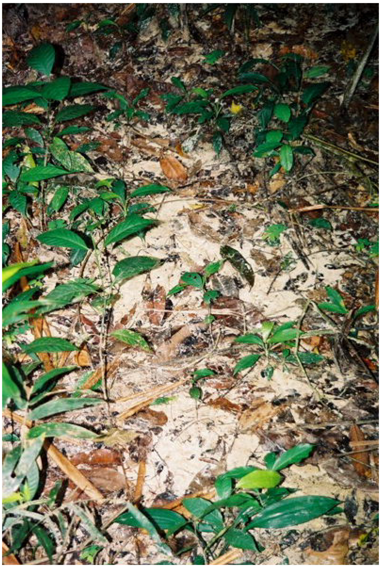
2.3. Effects on Riparian Habitat Structures

Riparian forest buffer zones provide important protection of streams from surface runoff. The riparian forest also provides allochthonous food and habitat structure, such as woody debris and leaf litter to the stream ecosystem. Thus, the assemblage of fish is usually related to riparian forest cover [64,65]. In agricultural areas, erosion gullies may break through gallery forests and destroy their structures (see Figure 1a). These confluence zones are hardly colonized at all by metazoans (see RC3 in Figure 4) because a steady or pulse-like inflow of sediment-charged water abrades all biologically colonized surfaces, removing biofilms and larger organisms. The confluence site is no longer protected by riparian vegetation; therefore it is a starting point for further bank erosion. On the bank of the stream opposite the mouth of the gully, sediment deposits up to several meters high may accumulate, depending on the energy of the water flow during the last discharge event in the erosion gully. These sediment deposits are then gradually undercut by the water and slump into the stream channel, to be transported downstream and eventually redeposited. As a consequence of loss of bank stabilization the stream bank begins to widen and may become braided [25,66]. In consequence, streams become completely altered by siltation. In a first phase, dams of organic material may develop, forming small ponds. As soon as these soft biological structures are sheared off, the remaining tree trunks are reduced to single boles and the braiding can widen the stream channel from several meters to hundreds of meters (Figure 6).
At gold mining sites the riparian forest is completely cleared in a ≥100 m wide strip along the stream [32]. The riparian forest downstream of the mining site may be impacted by the deposition of fine sediments during high-flow flood pulses (Figure 7).
Figure 6. Die-back of riparian vegetation and stream braiding due to excessive sediment deposition originating from agricultural erosion. See Wantzen [66] for details. © K.M. Wantzen, capture date of photograph July 1995.
Agriculture 03 00660 g006
Figure 7. Fine white sediment originating from upstream gold mining is deposited in the riparian forest along Mamanari Creek, Suriname, after inundation of the floodplain forest during a high-flow event. See Mol and Ouboter [34] for details. © Jan H. Mol (capture date of photograph 12 April 2001).
Agriculture 03 00660 g007

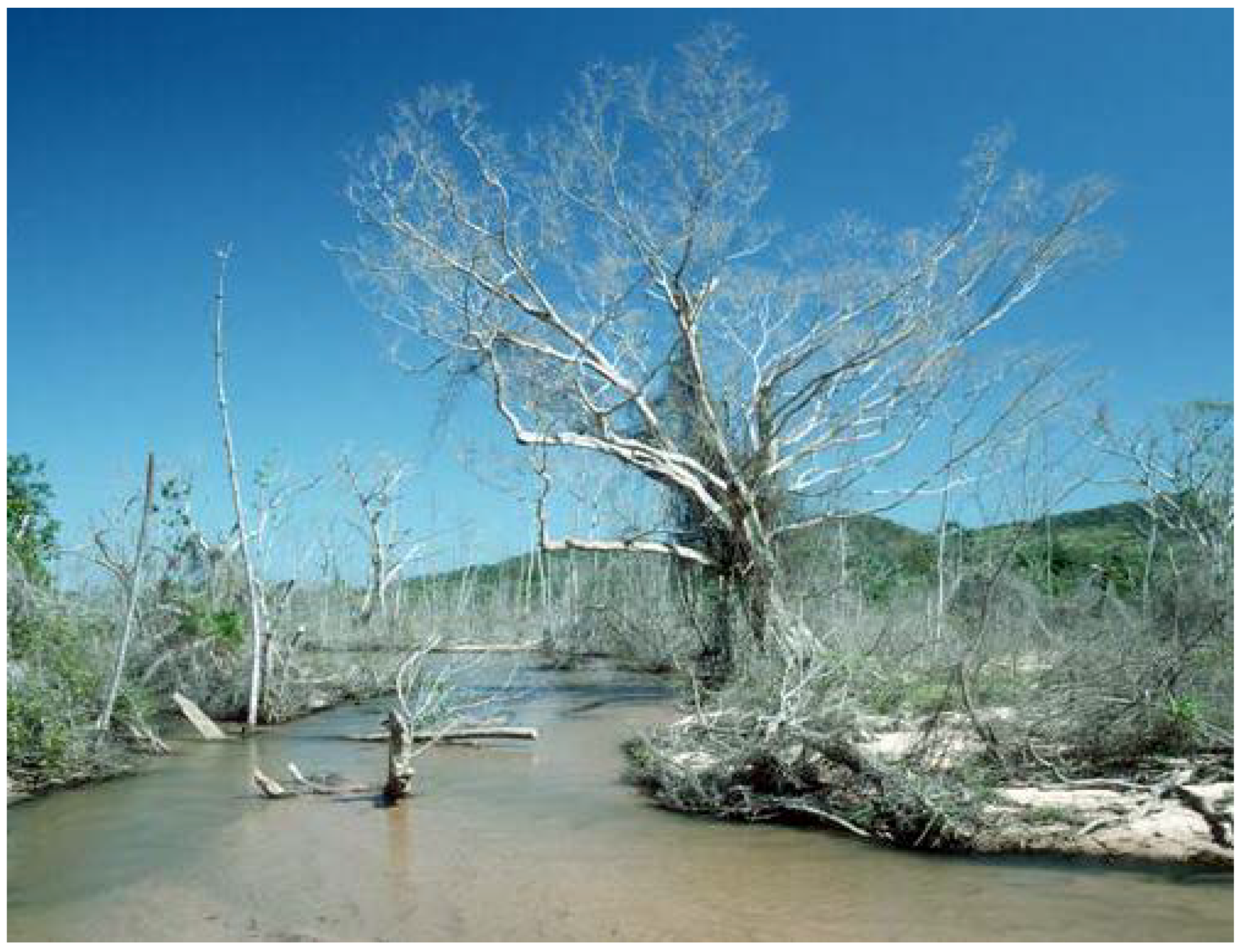
2.4. Effects on Riparian Animals and Plants

Deposited sediment layers cause anoxia and die-back of the riparian vegetation, whereas erosion initiating from the confluences of erosion gullies also undermines bank-stabilizing trees. In the first phase, the increase of retentive structures (dead trees) increases the residence time of organic matter (twigs and leaves) so that the number of decomposing organisms may be locally increased. The same is true for scavenging organisms and predators that can switch to the scavenging feeding mode. In the second phase (severe braiding), biodiversity is strongly reduced, only a few organisms (most of which have drifted down from the above stream sections) are found. Both in animals and plants, the ecological strategy switches from K-selected organisms (longer-lived, larger organisms that invest more energy in their offspring) towards r-selected species that produce large numbers of offspring in order to compensate eventual losses in these harsh and quickly changing environments [25,29,66].

3. Possible Actions

The first step towards erosion prevention is monitoring of the extent and location of erosion. Satellite imagery can help to efficiently monitor turbidity levels in large rivers [67], land use and riparian deforestation along streams (e.g., Figure 3b). Second comes management of the erosion problem by developing policies, legislation, communication, and erosion-prevention techniques, all within a watershed perspective [8] and based on monitoring data, stakeholder-participation and scientific knowledge. The use of effective soil conservation techniques in agricultural areas situated above the riparian zone is of paramount importance. The most important action is to avoid the development of large bare or sealed surfaces by facilitating the infiltration and percolation of rainwater at the place it comes down. In addition to the well-known soil-protective measures in the fields (contour ploughing, direct plantation, etc.), this can be performed by creating or maintaining vegetated buffer strips of interfluvial vegetation with an additional grass strip between the natural vegetation and the pasture [25,66]. In the highly erosion-sensitive areas, the whole stream valley and its vegetation sequence have to be considered for conservation. Access of livestock and dirt road construction should be completely excluded from the waterlogged or otherwise erosion-prone areas of the valley in order to avoid trampling paths that facilitate the development of surface runoff. The maintenance of both buffer strips in the transition zone between land use and the riparian zone, and the breadth of the protected riparian zone require political and legal support [25]. Legal enforcement is urgently needed here.
Apart from prevention, several restoration methods are available to restore environmental quality of streams that have been impacted by excessive sediment loads. Various techniques have been proposed to restore erosion gullies [67]; however, few of them have been effectively tested. The paramount problem is to permanently stop the movement of bed sediments, continued deepening of the gully bottom, and subsurface extension of the erosion gully (dendritic piping). First, direct surface runoff into the gully needs to be prevented and percolation of surface water near the gully needs to be reduced (to prevent further piping). Buffer zones can significantly contribute to this task as they keep road construction and cattle out of sensitive riparian zones where most erosion gullies initiate. The second step in restoration is the development of an environment suitable for plants to recolonize the gully. This can be accomplished by dam construction inside the gullies and stabilization of the bottom of the gullies and their surrounding vegetation. Very often, erosion has removed the topsoil including the seed bank, soil nutrients, humus, and essential clay-soil aggregates. The restoration of this soil layer may be very expensive. Therefore in most cases it is avoided, and natural succession of plants is retarded. However, unusual measures such as fish pond construction in erosion gullies may have considerable success [25]. Active planting of plants is a third step in the restoration (see plant list for the Brazilian Cerrado in [66]). Special care has to be taken to avoid plantation of non-native species that may invade other areas and outcompete regional plant species. Once established, the vegetation may be quickly eradicated by periods of drought or high discharge. Therefore a two-step strategy with a rapid stabilisation of the soils and sediments by quickly establishing pioneer plants (or even sugarcane grids) followed by introduction of woody plants is recommended [66]. Once the problems caused by erosion are under control, classical stream restoration measures can be used. However, natural succession should be preferred where possible. Deeply incised erosion gullies and stream channels may require levelling of the bank structures by heavy (and expensive) machinery.
To reduce impacts from gold mining, the Inter-American Development Bank recommends to (i) coordinate land-use planning across natural resources and resource use sectors (ii) tailor gold mining regulations and standards to background environmental and land use, (iii) support uptake of mitigation technologies to reduce sediment and mercury loading, (iv) encourage small operators to form collectives to normalize interactions and increase visibility, and to (v) internalize the environmental costs of impaired water quality and biodiversity loss [68].

4. Conclusions

Poor land use practices, including the removal of (riparian) forest cover, have caused increased rates of erosion in the Tropics. Land-based agriculture and gold mining in the headwater areas of catchments have resulted in chronic increases in the sediment load of streams. The increased suspended sediment load reduces light penetration and photosynthesis in the water and deposited sediment decreases instream habitat diversity by smothering aquatic macrophyte stands, clogging of gravels and hiding spaces, and covering of leaf litter, woody debris and other substrata. The stream ecosystem is affected both by direct impacts on the biota and by indirect effects via the food chain through reduced photosynthesis (bottom up) and reduced efficiency of visually-orienting predators (top down). As a result the structure (diversity) and functioning of the tropical stream communities have changed as is shown by changes in macroinvertebrate and fish assemblages. Nature reserves have been affected by mining and agriculture both within and upstream of the reserves. A consequence of the (longitudinal) hydrological connectivity of stream ecosystems is that ecosystems both up- and downstream of the point of sediment inflow can be affected by anthropogenic erosion disturbance (for example, turbidity inhibits upstream migration of fish and increases downstream accumulation of sediment). The accumulated sediment and associated contaminants are expected to leave a legacy of environmental problems long after the causes of erosion are corrected. Standards for turbidity and suspended solids should be set as some multiple of background levels upstream of a proposed activity [51]. The duration of exposure to elevated sediment levels should be included in the standards, as the impact of short pulses on the stream ecosystem is different from that of chronic exposure [41]. Monitoring data are the base of management, but they are often lacking in the Tropics [8]; however, turbidity levels in large rivers [69], land use practices, and clearance of riparian forest (Figure 3b) can be monitored efficiently using satellite imagery. A watershed perspective should be taken in addressing erosion-related problems in tropical streams [8], taking into account the legacy of past land use and cumulative effects from other stressors.

Acknowledgments

Paper # 1 of the UNESCO Chair “River Culture” and # 3 of the CARBIOCIAL project [70]. This paper resulted from discussions during the first ATIPA (Actions de formation Transfrontalières pour l’Intégration du Plateau des Guyanes en Amazonie) workshop in Cayenne, French Guyana, February 2013.

Conflicts of Interest

The authors declare no conflict of interest.

References

  1. Lal, R. Soils and food sufficiency. A review. Agron. Sustain. Dev. 2009, 29, 113–133. [Google Scholar] [CrossRef]
  2. Quinton, J.N.; Govers, G.; Van Oost, K.; Bardgett, R.D. The impact of agricultural soil erosion on biogeochemical cycling. Nature Geosci. 2010, 3, 311–314. [Google Scholar] [CrossRef] [Green Version]
  3. Lal, R. Soil erosion and the global carbon budget. Environ. Inter. 2003, 29, 437–450. [Google Scholar] [CrossRef]
  4. Pimentel, D.; Harvey, C.; Resosudarmo, P.; Sinclair, K.; Kurz, D.; McNair, M.; Christ, S.; Shrpirtz, L.; Fitton, L.; Saffouri, R.; et al. Environmental and economic costs of soil erosion and conservation benefits. Science 1995, 267, 1117–1123. [Google Scholar] [CrossRef]
  5. Sioli, H. Das Wasser im Amazonasgebiet. Forsch. Fortschr. 1950, 26, 274–280. [Google Scholar]
  6. Ryan, P.A. Environmental effects of sediments on New Zealand streams: A review. New Zealand J. Mar. Freshwater Res. 1991, 25, 207–221. [Google Scholar] [CrossRef]
  7. Malmqvist, B.; Rundle, S. Threats to the running water ecosystems of the world. Environ. Conserv. 2002, 29, 134–153. [Google Scholar]
  8. Castello, L.; McGrath, D.G.; Hess, L.L.; Coe, M.T.; Lefebre, P.A.; Petry, P.; Macedo, M.N.; Reno, V.F.; Arantes, C.C. The vulnerability of Amazon freshwater ecosystems. Conserv. Lett. 2013, 6, 217–229. [Google Scholar] [CrossRef]
  9. Boulton, A.J.; Boyero, L.; Covich, A.P.; Dobson, M.; Lake, P.S.; Pearson, R.G. Are Tropical Streams Ecologically Different from Temperate Streams? In Tropical Stream Ecology; Dudgeon, D., Ed.; Elsevier: Amsterdam, the Netherlands, 2008; pp. 257–284. [Google Scholar]
  10. Wantzen, K.M.; Junk, W.J. The Importance of Stream-Wetland-Systems for Biodiversity: A Tropical Perspective. In Biodiversity in Wetlands: Assessment, Function and Conservation; Gopal, B., Junk, W.J., Davies, J.A., Eds.; Backhuys: Leiden, the Netherlands, 2000; pp. 11–34. [Google Scholar]
  11. Wantzen, K.M.; Mathooko, J.; Yule, C.; Pringle, C.M. Organic Matter Processing in Tropical Streams. In Tropical Stream Ecology; Dudgeon, D., Ed.; Elsevier: Amsterdam, the Netherlands, 2008; pp. 43–64. [Google Scholar]
  12. Jacobsen, D.; Encalada, A. The macroinvertebrate fauna of Ecuadorian highland streams in the wet and dry season. Arch. Hydrobiol. 1998, 142, 53–70. [Google Scholar]
  13. Lewis, W.M., Jr.; Hamilton, S.K.; Saunders, J.F., III. Rivers of Northern South America. In River and Stream Ecosystems; Cushing, C.E., Cummins, K.W., Minshall, G.W., Eds.; Elsevier: New York, NY, USA, 1995; pp. 219–256. [Google Scholar]
  14. Wantzen, K.M. Physical pollution: Effects of gully erosion in a tropical clear-water stream. Aquat. Conserv. 2006, 16, 733–749. [Google Scholar] [CrossRef]
  15. Wantzen, K.M. Cerrado Streams—Characteristics of a threatened freshwater ecosystem type on the tertiary shields of South America. Amazoniana 2003, 17, 485–502. [Google Scholar]
  16. Johnson, D.L.; Lewis, L.A. Land Degradation: Creation and Destruction; Blackwell: London, UK, 1995; pp. 1–335. [Google Scholar]
  17. Nepstad, D.; McGrath, D.; Alencar, A.; Barros, A.C.; Carvalho, G.; Santilli, M.; Vera Diaz, M.C. Frontier governance in Amazonia. Science 2009, 295, 629–631. [Google Scholar]
  18. Veiga, M.M.; Hinton, J.J. Abandoned artisanal gold mines in the Brazilian Amazon: A legacy of mercury pollution. Nat. Resour. For. 2002, 26, 13–24. [Google Scholar]
  19. Heemskerk, M. Livelihood decision making and environmental degradation: Small-scale gold mining in the Suriname Amazon. Soc. Nat. Resour. 2002, 15, 327–344. [Google Scholar] [CrossRef]
  20. Swenson, J.J.; Carter, C.E.; Domec, J.C.; Delgado, C.I. Gold mining in the Peruvian Amazon: Global prices, deforestation, and mercury imports. PLoS One 2011, 6. [Google Scholar] [CrossRef] [Green Version]
  21. Ouboter, P.E.; Landburg, G.; Quik, J.; Mol, J.; van der Lugt, F. Mercury levels in pristine and gold mining impacted aquatic ecosystems of Suriname, South America. Ambio 2012, 41, 873–882. [Google Scholar] [CrossRef]
  22. Balogh, S.J.; Meyer, M.L.; Johnson, D.K. Transport of mercury in three contrasting river basins. Environ. Sci. Technol. 1998, 32, 456–462. [Google Scholar] [CrossRef]
  23. Secretaria de Assuntos Estratégicos (SAE) Impacto da revisão do Código Florestal: como viabilizar o grande desafio adiante? Internet report. Available online: http://www.sae.gov.br/site/?p=15735 (accessed on 24 September 2013).
  24. Silva, J.A.A.; Nobre, A.D.; Manzatto, C.V.; Joly, C.A.; Rodrigues, R.R.; Skorupa, L.A.; Nobre, C.A.; Ahrens, S.; May, P.H.; Sá, T.D.A.; et al. O Código Florestal e a Ciência: Contribuição para o Diálogo; Sociedade Brasileira para o Progresso da Ciência & Academia Brasileira de Ciências: São Paulo, Brazil, 2011; pp. 1–124. [Google Scholar]
  25. Wantzen, K.M.; Siqueira, A.; Nunes da Cunha, C.; Sa, M.F.P. Stream-valley systems of the Brazilian Cerrado: Impact assessment and conservation scheme. Aquat. Conserv. 2006, 16, 713–732. [Google Scholar] [CrossRef]
  26. Harding, J.S.; Benfield, E.F.; Bolstad, P.V.; Helfman, G.S.; Jones, E.B.D., III. Stream biodiversity: The ghost of land use past. Proc. Natl. Acad. Sci. USA 1998, 95, 14843–14847. [Google Scholar] [CrossRef]
  27. Batlle-Bayer, L. Changes in organic carbon stocks upon land use conversion in the Brazilian Cerrado: A review. Agric. Ecosyst. Environ. 2010, 137, 47–58. [Google Scholar] [CrossRef]
  28. Couto, E.G. O uso da terra e o garimpo na bacia do rio Sao Lourenco, Mato Grosso: Reflexos No Ambiente; FEMA/UFMT-CCA: Cuiabá, Mato Grosso, Brazil, 1990; p. 206. [Google Scholar]
  29. Wantzen, K.M. Influence of Man-Made Siltation on Habitat Structure and Biotic Communities of Cerrado Streams of Mato Grosso. Ph.D. Thesis, Herbert Utz Verlag, Munich, 1997; p. 186. [Google Scholar]
  30. Wantzen, K.M. Effects of siltation on benthic communities in clear water streams in Mato Grosso, Brazil. Verh. Int. Ver. Limnol. 1998, 26, 1155–1159. [Google Scholar]
  31. DellaSala, D.A.; Karr, J.R.; Olson, D.M. Roadless areas and clean water. J. Soil Water Conserv. 2011, 66, 78–84. [Google Scholar] [CrossRef]
  32. Peterson, G.D.; Heemskerk, M. Deforestation and forest regeneration following small-scale gold mining in the Amazon: The case of Suriname. Environ. Conserv. 2001, 28, 117–126. [Google Scholar]
  33. Centrum voor Landbouwkundig Onderzoek in Suriname (CELOS), Assessments of the extend of land categories, land uses and changes for the Second National Communication—AFOLU GHC Inventory 2011. CELOS, Natural Resources and Environmental Assessment: Paramarib, Suriname, 2011; unpublished work.
  34. Mol, J.H.; Ouboter, P.E. Downstream effects of erosion from small-scale gold mining on the instream habitat and fish community of a small neotropical rainforest stream. Conserv. Biol. 2004, 18, 201–214. [Google Scholar] [CrossRef]
  35. Power, M.E. The importance of sediment in the grazing ecology and size class interactions of the armored catfish, Ancistrus spinosus. Environ. Biol. Fish. 1984, 10, 173–181. [Google Scholar] [CrossRef]
  36. Davies-Colley, R.J.; Smith, D.G. Turbidity, suspended sediment, and water clarity: A review. J. Amer. Water Resources Ass. 2001, 37, 1085–1101. [Google Scholar] [CrossRef]
  37. Aksnes, D.L.; Nejstgaard, J.; Sœdberg, E.; Sørnes, T. Optical control of fish and zooplankton populations. Limnol. Oceanogr. 2004, 49, 233–238. [Google Scholar] [CrossRef]
  38. Walker, I. Amazonian Streams and Small Rivers. In Limnology in Brazil; Tundisi, J.G., Bicudo, C.E.M., Matsamura-Tundisi, T., Eds.; Brazilian Academy of Sciences: Rio de Janeiro, Brazil, 1995; pp. 167–194. [Google Scholar]
  39. Lau, D.C.P.; Leung, K.M.Y.; Dudgeon, D. What does stable isotope analysis reveal about trophic relationships and the relative importance of allochthonous and autochthonous resources in tropical streams? A synthetic study from Hong Kong. Freshwater Biol. 2009, 54, 127–141. [Google Scholar] [CrossRef]
  40. Brito, E.F.; Moulton, T.P.; de Souza, M.L.; Bunn, S.E. Stable isotope analysis indicates microalgae as the predominant food source of fauna in a coastal forest stream, south-east Brazil. Austral Ecol. 2006, 31, 623–633. [Google Scholar] [CrossRef]
  41. Newcombe, C.P.; MacDonald, D.D. Effects of suspended sediments on aquatic ecosystems. North Amer. J. Fish. Manage. 1991, 11, 72–82. [Google Scholar] [CrossRef]
  42. Waters, T.F. Sediments in Streams—Sources, Biological Effects, and Control; American Fisheries Society: Bethesda, MD, USA, 1995; p. 250. [Google Scholar]
  43. Kleeberg, A.; Köhler, J.A.N.; Sukhodolova, T.; Sukhodolov, A. Effects of aquatic macrophytes on organic matter deposition, resuspension and phosphorus entrainment in a lowland river. Freshwater Biol. 2010, 55, 326–345. [Google Scholar] [CrossRef]
  44. Brookes, A. Response of aquatic vegetation to sedimentation downstream from river channelisation works in England and Wales. Biol. Conserv. 1986, 38, 351–367. [Google Scholar] [CrossRef]
  45. Wantzen, K.M.; Junk, W.J. Aquatic-terrestrial linkages from streams to rivers: Biotic hot spots and hot moments. Arch. Hydrobiol. Suppl. 2006, 158, 595–611. [Google Scholar]
  46. Horeau, V.; Cerdan, P.; Champeau, A.; Richard, S. Importance of aquatic invertebrates in the diet of rapids-dwelling fish in the Sinnamary River, French Guiana. J. Trop. Ecol. 1998, 14, 851–864. [Google Scholar] [CrossRef]
  47. Odinetz Collart, O.; Jégu, M.; Thatcher, V.; Tavares, A.S. Les prairies aquatiques de l’Amazonie bresilienne. RSTOM Actualités 1996, 49, 8–14. [Google Scholar]
  48. Cope, W.G.; Bringolf, R.B.; Buchwalter, D.B.; Newton, T.J.; Ingersoll, C.G.; Wang, N.; Augspurger, T.; Dwyer, F.J.; Barnhart, M.C.; Neves, R.J.; et al. Differential exposure, duration, and sensitivity of unionoidean bivalve life stages to environmental contaminants. J. North Amer. Benthological Soc. 2008, 27, 451–462. [Google Scholar] [CrossRef]
  49. Wantzen, K.M.; Pinto-Silva, V. Uso de substratos artificiais para macroinvertebrados bentônicos para a avaliação do impacto de assoreamento em nascentes dos tributrios do Pantanal do Mato Grosso, Brasil. Revista Brasileira de Recursos Hídricos 2006, 11, 99–107. [Google Scholar]
  50. Bash, J. Effects of Turbidity and Suspended Solids on Salmonids; Center for Streamside Studies, University of Washington: Seattle, WA, USA, 2001; p. 74. [Google Scholar]
  51. Lloyd, D.S. Turbidity as a water quality standard for salmonid habitats in Alska. North Amer. J. Fish. Manage. 1987, 7, 34–45. [Google Scholar] [CrossRef]
  52. Bruton, M.N. The effects of suspensoids on fish. Hydrobiologia 1985, 125, 221–242. [Google Scholar] [CrossRef]
  53. Gende, S.M.; Edwards, R.T.; Willson, M.F.; Wipfli, M.S. Pacific salmon in aquatic and terrestrial ecosystems. BioScience 2002, 52, 917–928. [Google Scholar] [CrossRef]
  54. Carolsfeld, J.; Harvey, C.; Ross, C.; Baer, A. Migratory Fishes of South America: Biology, Fisheries and Conservation; International Development Centre & the World Bank: Ottawa, Ontario, Canada, 2003; p. 372. [Google Scholar]
  55. Cederholm, C.J.; Salo, E.O. The Effects of Logging Road Landslide Siltation on the Salmon and Trout Spawning Gravels of Stequaleho Creek and Clearwater River Basin, Jefferson County, Washington, 1972–1978; Fisheries Research Institute, University of Washington: Seattle, WA, USA, 1979; p. 90. [Google Scholar]
  56. Van der Sluijs, I.; Gray, S.M.; Amorim, M.C.P.; Candolin, U.; Hendry, A.P.; Krahe, R.; Maan, M.F.; Utne-Palm, A.C.; Wagner, H.J.; Wong, N.B.M. Communication in troubled waters: Responses of fish communication systems to changing environments. Evol. Ecol. 2011, 25, 623–640. [Google Scholar] [CrossRef]
  57. Keenleyside, M.H.A. Some aspects of schooling in fish. Behaviour 1955, 8, 183–249. [Google Scholar] [CrossRef]
  58. Keenleyside, M.H.A.; Bietz, B.F. The reproductive behavior of Aequidens vittatus (Pisces, Cichlidae) in Surinam, South America. Environ. Biol. Fish. 1981, 6, 87–94. [Google Scholar] [CrossRef]
  59. Seehausen, O.; Van Alphen, J.J.M.; Witte, F. Cichlid fish diversity threatened by eutrophication that curbs sexual selection. Science 1997, 277, 1808–1811. [Google Scholar] [CrossRef]
  60. Dias, A.M.; Tejerina-Garro, F.L. Changes in the structure of fish assemblages in streams along an undisturbed-impacted gradient, upper Parana River basin, Central Brazil. Neotrop. Ichthyol. 2010, 8, 587–598. [Google Scholar] [CrossRef]
  61. Mol, J.H.; You, K.W.T.; Vrede, I.; Flynn, A.; Ouboter, P.; van der Lugt, F. Fishes of Lely and Nassau Mountains, Suriname. In a Rapid Biological Assessment of the Lely and Nassau Plateaus, Suriname (with Additional Information on the Brownsberg Plateau); Alonso, L.E., Mol, J.H., Eds.; Conservation International: Arlington, TX, USA, 2007; pp. 107–118. [Google Scholar]
  62. Lujan, N.K.; Roach, K.A.; Jacobsen, D.; Winemiller, K.O.; Vargas, V.M.; Ching, V.R.; Maestre, J.A. Aquatic community structure across an Andes-to-Amazon fluvial gradient. J. Biogeogr. 2013. [Google Scholar]
  63. Moyle, P.B.; Leidy, R.A. Loss of Biodiversity in Aquatic Ecosystems: Evidence from Fish Faunas. In Conservation Biology; Fiedler, P.L., Jain, S.K., Eds.; Chapman & Hall: New York, NY, USA, 1992; pp. 127–169. [Google Scholar]
  64. Burcher, C.L.; McTammany, M.E.; Benfield, E.F.; Helfman, G.S. Fish assemblage responses to forest cover. Environ. Manage. 2008, 41, 336–346. [Google Scholar] [CrossRef]
  65. Casatti, L.; Ferreira, C.P.; Carvalho, F.R. Grass-Dominated stream sides exhibit low fish diversity and dominance by guppies: An assessment of two tropical pasture river basins. Hydrobiologia 2009, 632, 273–283. [Google Scholar] [CrossRef]
  66. Wantzen, K.M.; Nunes da Cunha, C.; Siqueira, A.J.B. Cerrado Stream Valleys and their Vegetation: Structure, Impacts by Erosion and Recuperation Strategies. In the Pantanal: Ecology, Biodiversity and Sustainable Management of a Large Neotropical Seasonal Wetland; Junk, W.J., da Silva, C.J., Nunes da Cunha, C., Wantzen, K.M., Eds.; Pensoft: Moscow and Sofia, Russia, 2011; pp. 143–165. [Google Scholar]
  67. Valentin, C.; Poesem, J.; Li, Y. Gully erosion: Impacts, factors and control. Catena 2005, 63, 132–153. [Google Scholar] [CrossRef]
  68. Hammond, D.S.; Rosales, J.; Ouboter, P.E. Managing the Freshwater Impacts of Surface Mining in Latin America; IDB Technical Note 519; Inter-American Development Bank: Washington, DC, USA, 2013; p. 36. [Google Scholar]
  69. Wang, J.J.; Lu, X.X.; Liew, S.C.; Zhou, Y. Retrieval of suspended sediment concentrations in large turbid rivers using Landsat ETM+: An example from the Yangtze River, China. Earth Surf. Process. Landf. 2009, 34, 1082–1092. [Google Scholar] [CrossRef]
  70. CARBIOCIAL (Carbon Sequestration, Biodiversity and Social Structures in Southern Amazonia: Models and Implementation of Carbon-Optimized Land Management Strategies) Project. Available online: http://www.carbiocial.de/ (accessed on 24 September 2013).

