Article

Tools for Urban Climate Adaptation Plans: A Case Study on Bologna and Outcomes for Heat Wave Impact Reduction

1
Institute for the BioEconomy Italian National Research Council, Via Gobetti 101, 40129 Bologna, Italy
2
Italian National Municipalities Association Emiia-Romangna Section (ANCI-ER), Via Solferino 42, 40128 Bologna, Italy
3
URDIS, University of Camerino, Lungomare Scipioni 6, 63074 San Benedetto del Tronto, Italy
*
Author to whom correspondence should be addressed.
Challenges 2023, 14(4), 48; https://doi.org/10.3390/challe14040048
Submission received: 8 September 2023 / Revised: 17 November 2023 / Accepted: 27 November 2023 / Published: 29 November 2023

Abstract

:
The purpose of this paper is to describe the process of building a coherent frame for the identification of local environmental urban vulnerabilities, coping with heat waves’ increasing threats, and adopting specific adaptation policies in the Emilia-Romagna region. A microclimate model (ENVI-met) was used to simulate temperature regimes in five areas of Bologna, providing ex ante maps enabling us to locate the most vulnerable areas. Adaptation measures were suggested with the support of WMO Guidance 1234 and included recommendations about the introduction of high-albedo building materials and nature-based solutions. The step-by-step methodology developed, coupling local vulnerabilities with adaptation recommendation, integrates a scientific methodology into a political decision. The results, allowing us to widely represent this city’s vulnerability, are considered outstanding with respect to supporting the city’s adaptation ambitions and are now part of the running Bologna General Urban Plan (PUG), which regulates building interventions, introducing the obligation for enterprises to respect or ameliorate the microclimate in all the areas in which they intervene. This tool can be replicated and adapted to any municipal area, as it integrates authoritative WMO solutions with accurate microclimate assessment, thus providing locally tailored adaptation interventions. This paper aims to support the vision, shared by both science and policy makers, of transforming cities into widely resilient systems.

1. Introduction

Adaptation is urgently required in order to face immediate sustainability problems [1,2], pandemics, and climate extremes that have unprecedently highlighted the fragility of territorial structures and services at the social level [3,4]. The necessity of putting in place adequate tailored actions will become even more stressed as, in the coming decades, most of the world population will live in cities (more than 68% by 2050) [5]. To minimize the impacts of potential adverse changes on urban areas and their infrastructure and surroundings, as well as on people and other organisms, the establishment of long-term climate adaptation policies at the local level is hence becoming more and more critical [6]. The proactive involvement of policy makers in meeting local expectancies to reach urban resiliency and adaptation is thus substantial. As a first action in 2008, the pact of Mayors [7] considered mitigation as the objective, mostly addressing efforts towards reducing CO2 levels at the global scale [8].
In 2014, the Mayors Adapt initiative increased the focus on adaptation, inviting local governments to join forces to develop and implement local strategies within SECAP local planning (Sustainable Energy and Climate Action Plans) [9]. The resulting “Global Covenant of Mayors for Climate and Energy” has become the most important commitment of governments to transcending the previous national climate and energy objectives, aligning with the UN Sustainable Development Goals. Such a transition to a joint, enlarged objective based on climate threats underlies the logic of combining mitigation and adaptation as a way of constructing a sustainable and resilient future.
The elaboration of climate adaptation plans is a complex process that integrates the quantification of the potential magnitudes of impacts, the assessment of local risks compared to a baseline, and the identification of progress-monitoring indicators [10,11]. For cities, the planning is even more complicated as climate hazards are strongly linked to the internal texture, arrangement, and organization of a city itself; consequently, its capacity for spontaneous adaptation will be reduced [12,13].
Spatial planning, along with adequately addressing its components (urban green, blocks, and soil sealing), is now presenting a substantial opportunity to focus on growing climate threats and hazards for populations [14,15]. In particular, there is increasing evidence of a more frequent occurrence of heat islands in cities, where block texture is dense and non-permeable surfaces with high albedo and emissivity are dominant [16].
This paper focuses on a project undertaken in the Emilia-Romagna region to build a coherent framework for the identification of local environmental urban vulnerabilities.
The region’s capital city, Bologna, as evidenced in its SECAP, faces heat waves, together with heavy precipitation and drought, serving as the main climate threats for this territory. To provide support for policy, here, we simulate temperature regimes in five areas of the city, providing ex ante maps to locate the most vulnerable areas, and we include WMO guidance recommendations for coping with heat waves’ increasing occurrence.

Tools for Urban Climate Adaptation Planning

Recently, the WMO, within the framework of the National Frameworks for Climate Services, recognized the necessity of fully addressing the urban adaptation actions worldwide [17] and consequently encouraged national meteorological services to establish active working relationships with Public Administrations (PAs), recommending a joint agreement on resource identification and service delivery.
Specifically, guidance (WMO 1234) was formulated to provide PAs with the paths to resilience according to their local characteristics (Table 1).
Additional indications about dealing with adaptation stem from the National Adaptation Plans (NAPs) [18], which provide a vision of climate change impacts in multiple socio-economic sectors and natural systems, identifying a set of actions and guidelines for coping with them.
In Italy, NAPs are part of the strategic vision set by the Ministry of Environment in 2015 (the National Strategy for Climate Change Adaptation (SNACC)) [19]. This strategy was explicitly devised to allow PAs to create a coherent framework for adaptation. However, even if PAs widely accepted it, (361 sectorial adaptation actions and 21 relevant actions), an “old style” in landscape and urban planning still resists change at the technical and political levels, and a revaluation is urged.
Table 2 aggregates the new practices that Italian PAs are generally suggested to follow according to policy administrative mandates.
PAs’ previously gained capacity to develop energy-dedicated plans has not yet been integrated with specific skills and competences for dealing with the climate action included in the new plans agreed (SECAP). Furthermore, the formulation of adaptation plans requires comprehensive knowledge of local vulnerability [7,8]. As a consequence, most PAs with limited economic and human resources are facing critical issues in operationally developing SECAPs [20,21,22].
The WMO guide is a recognized, promising tool able to support PAs’ with tools considering potential impacts on landscape, environment, social, and economic components.
In this work, we seek to integrate the content of some of the existing tools and evaluate their performance and applicability, including the WMO 1234 theoretical guidance, for the urban situation in Bologna as a case study for larger applications. In particular, we focused on the urgent threats to supporting urban-planning actions capable of mitigating summer heat waves.

2. Methods

Our study was carried out on Bologna (Italy), the capital city of Emilia Romagna region. Frequent summer heat waves experienced in the last few years in the dense peri-urban area prompted local authorities to set up a number of active alerts and prevention measures for the population, especially for weaker individuals [23].
In Figure 1, we present the regulatory and implementation paths from the global to the local level. In the context of such a complex framework, we concentrated the current study on the implementation of the substantial step marked in red, providing scientifically based support for the General Urban Plan (PUG).
As a first step (Methodology 1 in Figure 2), we ran ENVI-met, a three-dimensional non-hydrostatic fluid dynamic model operating with a spatial resolution of 0.5–10 m and a temporal resolution of 10 s [24]. ENVI-met simulates various variables, including the anemological flow around and between buildings, the processes of heat and vapor exchange both at the ground surface and on the walls, turbulent exchanges, some vegetation parameters, bioclimatology, and particle dispersion. We selected it because of its flexibility in representing ex ante and ex post phenomena occurring in the presence of urban canyons (common in Bologna’ texture), such as the effects of the building/green ratio on comfort and physical mitigation solutions.
Representative areas of Bologna were chosen, prioritizing those marked by a recognized critical vulnerability, i.e., areas in which the percentage of green surfaces is low and, at the same time, the percentage of the population above 65 years and younger than 4 is high (weaker groups).
Once the selected descriptive urban fabric typologies were defined, the model was run for each of them (Corticella, Bolognina, Masi, Barca, and Roveri) under the same initial weather conditions. Meteorological data from ARPAE Emilia Romagna were provided by the urban weather station located in the very center of the city. The microclimate simulation was carried out for the day on which, during the heat wave that occurred in summer 2017, the maximum temperature was recorded (August 4th). Air temperature output maps, as shown in Figure 3, were then overlaid onto Google Maps to represent local configurations and assess local vulnerability.
Starting from the assumption that actions ensuring that weaker individuals are living in conditions of microclimate/physiological safety guarantee all citizens’ general safety, vulnerability was defined as the occurrence of high temperatures near buildings most frequented by weaker groups (e.g., pharmacies, clinics, social centers, schools, gardens, and neighborhood squares) (Methodology 2 in Figure 2).
In addition, we marked as vulnerable places those where the quantity and size of natural/environmental elements already present are low but can potentially be enhanced through active interventions (exclusive public areas, in which the municipality could directly act, and areas in which private subjects may intervene after agreement with the PA).
Based on the work conducted by Nardino et al. (2021) [26], Bologna morphological/climatic classification was used to represent larger-scale vulnerability (Figure 4) and suggest blocks for which adaptation interventions should be prioritized (Methodology 3 in Figure 2). A deviation value from equilibrium was defined for each class:
  • Class A—low fragility → close to equilibrium;
  • Class B—medium-low fragility → low deviation from equilibrium;
  • Class C—medium-high fragility → substantial deviation from equilibrium;
  • Class D—high fragility → high deviation from equilibrium.
WMO1234 solutions suitable for mitigating the physiological/climatic hazards in the identified places and provide tailored contributions to the city’s PUG were then selected to address local critical situations potentially occurring during heat waves.

3. Result and Discussion

Bologna’s current SECAP identifies a broad scope for short- and long-term actions in public spaces (gardens, streets, squares, public buildings schools, etc.) (Table 3). In the historical, consolidated areas of Bologna’ urban territory, a deficient availability of greenery per inhabitant (even less than 5 square meters) was recorded.
The desealing and greening of such areas are often very limited by the structure of the consolidated city itself. A reasonable contribution to adaptation to heat islands thus becomes essential. Urban planning and building interventions must take into account the effects of incident solar radiation on external surfaces, the absorption coefficients of building materials, the urban morphology, and the type and shape of vegetation.
Each fragility class reported in Figure 4 was associated with a performance level intended to be achieved when planning is implemented (Result 4 in Figure 2):
  • Class A—maintenance—the microclimate well-being brought about by the new planning conditions must be greater than or equal to the well-being in the existing conditions;
  • Class B—basic level—the microclimate well-being brought about by the new planning conditions must be better than the well-being of the existing conditions by at least 10%, with the overall albedo of the surfaces (shortwave reflection) affected by the intervention being greater than or equal to 40%;
  • Class C—improvement level—the microclimate well-being brought about by the new planning conditions must be better than the well-being of the existing conditions by at least 15%, with the overall albedo of the surfaces affected by the intervention being greater than or equal to 50%;
  • Class D—excellent level—the microclimate well-being brought about by the new planning conditions must be at least 20% better than the well-being of the existing conditions, with the overall albedo of the surfaces affected by the intervention being greater than or equal to 60%.
It is implicit that any introduction of appropriate materials, characterized by high reflectance, such as vegetation or lightly colored building materials, may support a reduction in heat wave effects and improve bio-microclimate indices [28].
The results of this study, allowing us to widely represent the city’s vulnerability, have been considered outstanding with respect to supporting the city’s adaptation ambitions. Therefore, the step-by-step methodology (Results 1 and 2 in Figure 2) and the morphological–climatic classification (Result 3 in Figure 2) are now part of the running General Urban Plan (PUG) [29], which regulates building interventions, introducing the obligation for building enterprises to respect or ameliorate the microclimate in all the areas in which they intervene. Figure 2 summarizes the actions carried out in this study and their integration in the PUG.

4. Conclusions

The assessment procedure developed herein, coupling local vulnerabilities with adaptation recommendation, integrates a scientific methodology into a political decision [25,30]. This can be considered an active contribution to support a vision, shared by both parties, to transform the city into a widely resilient system.
The step-by-step methodology adopted can be replicated and adapted to any municipal area, as it integrates authoritative WMO solutions with an accurate definition of vulnerable areas, thus providing locally tailored interventions. Guolo et al. [23] reported that there was a positive association between summer temperatures and the number of emergency department visits in Bologna, expanding the study to different socioeconomic contexts. The additional application of microclimate characterization confirms that better planning for the protection of fragile populations during heat waves is possible and may help residents to cope with poor microclimates.
From a broader perspective, the coming increase in heat wave threats requires the design of an equitable city texture, for example, determining the appropriate locations of hospitals, schools, or commercial centers, and correct green designs that include secure pathways for fragile populations. Municipalities are the actors called upon to play a key role because of their proximity to citizens in daily processes, and they are the institutional subjects committed to the necessary environmental, relational, and social transformations. PAs are then forced to make a definitive transition from adopting symptomatic solutions, often dictated by emergencies, to implementing deep systemic ones moving towards real sustainability, the protection of resources, and high-environmental-quality models [31].
Our results show how a dialogue between politics and science may concretize actions necessary for change.
The approach of this study can be, and already has been, adopted by other PAs as a best practice in order to identify and overcome vulnerabilities, mostly in places frequented by weaker groups.
However, this study is also intended be an invitation for large and small PAs to review the fundamental contents of their databases, to reorganize in terms of the cross-fertilization of the problems, so that knowledge of this territory is not fragmented in different offices, which are often unable to interact and communicate each other.
To further operationally implement this adaptation plan, additional model runs will be critical to simulating potential ex post scenarios according to PA’s designs. Such advancement will allow for the verification of which positive microclimate effects can be achieved when applying the various design solutions and support the implementation of those most appropriate. By pursuing this direction, decision-makers can overcome the concept of sustainable development strategies and enable “Smart Cities” to evolve and become “Healthy Cities” [32].

Author Contributions

Conceptualization, L.C., T.G., F.R., M.N. and A.R.; methodology, L.C., T.G., M.N. and A.R.; software, L.C. and M.N.; validation, L.C.; formal analysis, M.N., T.G., G.P. and M.F.; investigation, L.C., T.G. and M.N.; resources, L.C., T.G. and G.P.; data curation, L.C. and G.P.; writing—original draft preparation, L.C., T.G., A.R. and M.F.; writing—review and editing, L.C., T.G. and M.N.; visualization, L.C., T.G. and M.N.; supervision, T.G.; project administration, T.G. and A.R.; funding acquisition, none. All authors have read and agreed to the published version of the manuscript.

Funding

This study was funded by ECOSYSTEM FOR SUSTAINABLE TRANSITION IN EMILIA-ROMAGNA (ECOSISTER). PROGETTO PNRR Programma di Ricerca e Innovazione—code ECS0000003 NextGenerationEU, Piano Nazionale di Ripresa e Resilienza (PNRR) –MISSIONE 4 COMPONENTE 2.

Data Availability Statement

Publicly available datasets were analyzed in this study. This data can be found here: [http://sit.comune.bologna.it/alfresco/d/d/workspace/SpacesStore/17a5f006-62e2-4364-8cec-bedc075ca833/DisciplinaDelPiano_APPRweb.pdf].

Conflicts of Interest

The authors declare no conflict of interest.

References

  1. Badura, T.; Krkoška Lorencová, E.; Ferrini, S.; Vačkářová, D. Public support for urban climate adaptation policy through nature-based solutions in Prague. Landsc. Urban Plan. 2021, 215, 104215. [Google Scholar] [CrossRef]
  2. Morabito, M.; Crisci, A.; Gioli, B.; Gualtieri, G.; Toscano, P.; di Stefano, V.; Orlandini, S.; Gensini, G.F. Urban-Hazard Risk Analysis: Mapping of Heat-Related Risks in the Elderly in Major Italian Cities. PLoS ONE 2015, 10, e0127277. [Google Scholar] [CrossRef] [PubMed]
  3. Cheval, S.; Mihai Adamescu, C.; Georgiadis, T.; Herrnegger, M.; Piticar, A.; Legates, D.R. Observed and Potential Impacts of the COVID-19 Pandemic on the Environment. Int. J. Environ. Res. Public Health 2020, 17, 4140. [Google Scholar] [CrossRef]
  4. Ferrini, F.; Gori, A. How Trees and Green Infrastructures Can Help Shaping a Sustainable Future. Ri-Vista 2020, 19, 182–191. [Google Scholar]
  5. United Nations Department of Economic and Social Affairs. 68% of the World Population Projected to Live in Urban Areas by 2050, Says UN, New York. Available online: https://www.un.org/development/desa/en/news/population/2018-revision-of-world-urbanization-prospects.html (accessed on 4 August 2023).
  6. Mullenbach, L.E.; Baker, B.L.; Mowen, A.J. Does Public Support of Urban Park Development Stem from Gentrification Beliefs and Attitudes? Landsc. Urban Plan 2021, 211, 104097. [Google Scholar] [CrossRef]
  7. Covenant of Mayors—Europe. EU Cities Save Energy. Available online: https://eu-mayors.ec.europa.eu/en/home (accessed on 4 August 2023).
  8. Climate Action. Climate Strategies & Targets. Available online: https://ec.europa.eu/clima/policies/strategies_en (accessed on 4 August 2023).
  9. The Compact of Mayors—C40 Cities Climate Leadership Group. Available online: https://www.c40.org/researches/compact-of-mayors (accessed on 4 August 2023).
  10. Russo, A.; Cirella, G.T. Urban Ecosystem Services: New Findings for Landscape Architects, Urban Planners, and Policymakers. Land 2021, 10, 88. [Google Scholar] [CrossRef]
  11. Felice, E.; Vignoli, V.; Fiorani, F.; Corradini, E.; Minelli, A. Urban Trees Felling and Failures: Preliminary Results from an Investigation on an Urban Green Infrastructure—Locating the Most Sensitive Species and Defining the Causes. Acta Hortic. 2022, 1345, 209–214. [Google Scholar] [CrossRef]
  12. SOS4LIFE Project. Freeing the Soil 20 Case Studies for Urban Resilience Adaptation Projects and Processes in Regeneration Interventions. 2020. Available online: https://www.sos4life.it/wp-content/uploads/SOS4LIFE_lineeguida_02_ENG_v12_LR.pdf (accessed on 2 November 2022).
  13. SOS4LIFE Project. Freeing the Guidelines for Improving Resilience to Climate Change in Urban Regeneration Processes. 2020. Available online: https://www.sos4life.it/wp-content/uploads/SOS4LIFE_lineeguida_EN_01_1.pdf (accessed on 2 November 2022).
  14. Davoudi, S. Climate Risk and Security: New Meanings of “the Environment” in the English Planning System. Eur. Plan. Stud. 2012, 20, 49–69. [Google Scholar] [CrossRef]
  15. Thoidou, E. Spatial Planning and Climate Adaptation: Challenges of Land Protection in a Peri-Urban Area of the Mediterranean City of Thessaloniki. Sustainability 2021, 13, 4456. [Google Scholar] [CrossRef]
  16. Ward, K.; Lauf, S.; Kleinschmit, B.; Endlicher, W. Heat waves and urban heat islands in Europe: A review of relevant drivers. Sci. Total Environ. 2016, 569–570, 527–539. [Google Scholar] [CrossRef] [PubMed]
  17. WMO. Guidance on Integrated Urban Hydrometeorological, Climate and Environmental Services—Volume I: Concept and Methodology; WMO: Geneva, Switzerland, 2019. [Google Scholar]
  18. UNFCCC. National Adaptation Plans. Available online: https://unfccc.int/topics/adaptation-and-resilience/workstreams/national-adaptation-plans (accessed on 4 August 2023).
  19. Ministry for the Environment. Strategia Nazionale di Adattamento ai Cambiamenti Climatici. Available online: https://www.mite.gov.it/notizie/strategia-nazionale-di-adattamento-ai-cambiamenti-climatici-0 (accessed on 4 August 2023).
  20. Grimmond, S.; Bouchet, V.; Molina, L.T.; Baklanov, A.; Tan, J.; Schlünzen, K.H.; Mills, G.; Golding, B.; Masson, V.; Ren, C.; et al. Integrated Urban Hydrometeorological, Climate and Environmental Services: Concept, Methodology and Key Messages. Urban Clim. 2020, 33, 100623. [Google Scholar] [CrossRef] [PubMed]
  21. WMO. Guidance on Integrated Urban Hydrometeorological, Climate and Environmental Services—Volume II: Demonstration Cities; WMO: Geneva, Switzerland, 2019. [Google Scholar]
  22. Climate Adapt—Sharing Adaptation Information across Europe, Urban Adaptation Support Tool, 5. Implementing Adaptation. Available online: https://climate-adapt.eea.europa.eu/knowledge/tools/urban-ast/step-5-2 (accessed on 4 August 2023).
  23. Guolo, F.; Stivanello, E.; Pizzi, L.; Georgiadis, T.; Cremonini, L.; Musti, M.A.; Nardino, M.; Ferretti, F.; Marzaroli, P.; Perlangeli, V.; et al. Emergency Department Visits and Summer Temperatures in Bologna, Northern Italy, 2010–2019: A Case-Crossover Study and Geographically Weighted Regression Methods. Int. J. Environ. Res. Public Health 2022, 19, 15592. [Google Scholar] [CrossRef] [PubMed]
  24. Bruse, M.; Fleer, H. Simulating Surface–Plant–Air Interactions inside Urban Environments with a Three Dimensional Numerical Model. Environ. Model. Softw. 1998, 13, 373–384. [Google Scholar] [CrossRef]
  25. Cremonini, L.; Nardino, M.; Georgiadis, T. The Utilization of the WMO-1234 Guidance to Improve Citizen’s Wellness and Health: An Italian Perspective. Int. J. Environ. Res. Public Health 2022, 19, 15056. [Google Scholar] [CrossRef] [PubMed]
  26. Nardino, M.; Cremonini, L.; Georgiadis, T.; Mandanici, E.; Bitelli, G. Microclimate Classification of Bologna (Italy) as a Support Tool for Urban Services and Regeneration. Int. J. Environ. Res. Public Health 2021, 18, 4898. [Google Scholar] [CrossRef] [PubMed]
  27. Municipality of Bologna. Territorial Information System. Available online: https://sit.comune.bologna.it/alfresco/d/d/workspace/SpacesStore/a45d9c92-90cb-4bc0-bc1b-3ce6f943ac8c/Fragilita_microclimatica.pdf (accessed on 4 August 2023).
  28. Staiger, H.; Laschewski, G.; Matzarakis, A. Selection of Appropriate Thermal Indices for Applications in Human Biometeorological Studies. Atmosphere 2019, 10, 18. [Google Scholar] [CrossRef]
  29. Municipality of Bologna. Discipline of the General Urban Plan of the Municipality of Bologna. Available online: http://sit.comune.bologna.it/alfresco/d/d/workspace/SpacesStore/17a5f006-62e2-4364-8cec-bedc075ca833/DisciplinaDelPiano_APPRweb.pdf (accessed on 4 August 2023).
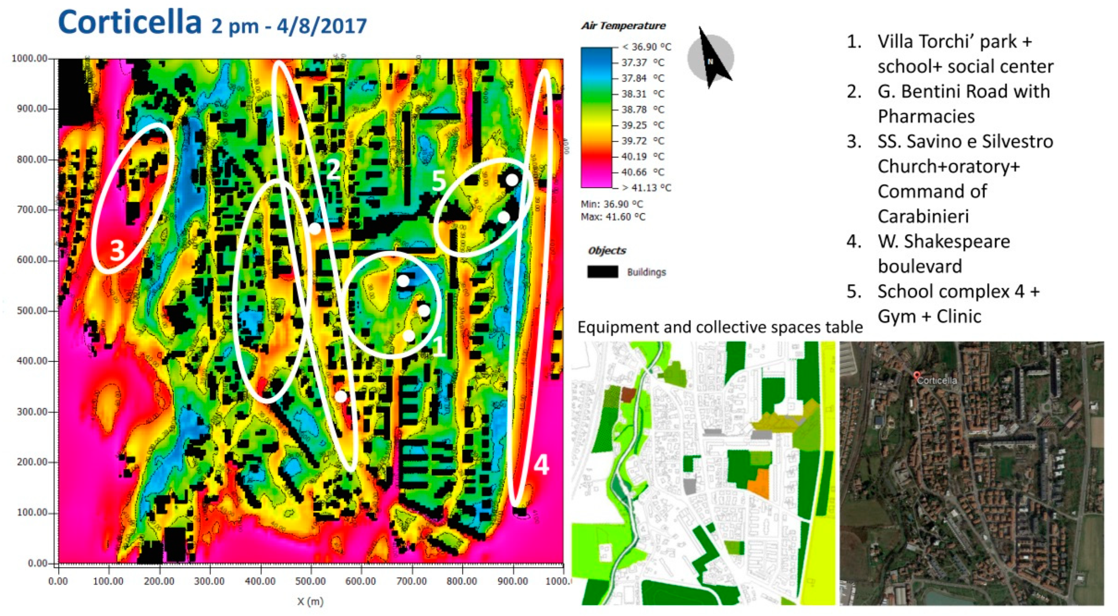
  30. Nardino, M.; Cremonini, L.; Crisci, A.; Georgiadis, T.; Guerri, G.; Morabito, M.; Fiorillo, E. Mapping Daytime Thermal Patterns of Bologna Municipality (Italy) during a Heatwave: A New Methodology for Cities Adaptation to Global Climate Change. Urban Clim. 2022, 46, 101317. [Google Scholar] [CrossRef]
  31. Zaccagni, L.; Toselli, S.; Barbieri, D. Physical Activity during COVID-19 Lockdown in Italy: A Systematic Review. Int. J. Environ. Res. Public Health 2021, 18, 6416. [Google Scholar] [CrossRef] [PubMed]
  32. Pazzini, M.; Corticelli, R.; Lantieri, C.; Mazzoli, C. Multi-Criteria Analysis and Decision-Making Approach for the Urban Regeneration: The Application to the Rimini Canal Port (Italy). Sustainability 2023, 15, 772. [Google Scholar] [CrossRef]
Figure 1. Salient regulatory and implementation steps concerning urban adaptation to climate change, from the global to the local level. Acronyms: SEAP (Sustainable Energy Action Plan); CC (Climate Change); SECAP (Sustainable Energy and Climate Action Plan); SNACC (National Adaptation Strategy for Climate Change); PNACC (National Adaptation Plan for Climate Change); REBUS project (Renovation of Public Buildings and Urban Spaces). Source: created by authors.
Challenges 14 00048 g001
Figure 2. Summary of the methodologies applied in the context of the PUG that have been approved and included in the regulatory framework. For each methodology, details are provided within the mentioned bibliography. Source: drawn by authors. References for methodology 2 [25], for methodology 3 [26].
Challenges 14 00048 g002
Figure 3. Corticella area: Air temperature (1.8 m from the soil surface) map in which vulnerable sub-areas are identified (circled in white) as the places usually frequented by vulnerable groups. Source: Cremonini et al. [25].
Challenges 14 00048 g003
Figure 4. Map of microclimate vulnerability—low (A), low-medium (B), medium-high (C), high (D)—indicating the blocks for which an intervention via the PUG is suggested in order to apply adaptation measures [27]. Source: drawn by authors.
Challenges 14 00048 g004
Table 1. Urban services and nature-based (NB) solution approaches summarized by Authors from WMO guidance. Table highlights key issues for this study [17].
Urban servicesUrban services refer to transportation, housing, water and waste management, snow clearance, and so forth. Services may be provided directly through country member operations or indirectly through stakeholders or partners in public and private agencies. Services include weather forecasts, extreme event monitoring, and climate services for building codes, zoning, planning, and design. Integrated urban services inherently have high resolution and are provided at roughly the spatial scale of the urban footprint and at smaller scales. However, they are highly dependent on the application, requirements, and local and regional factors. The urban domain may include surrounding areas, nearby cities, connection roads, rural watersheds, and industries in order to capture their impacts. Planning in major metropolitan areas will affect housing, transportation, and recreation.
Nature-based solutionsNBS are the best solutions for cities. An ecosystems approach for urban design considers blue and green solutions—where blue refers to adding water elements and green refers to adding trees and parks—and requires weather, climate, hydrological, and air quality information for design and management.
Urban services and city designCapacity building is a basic step for the adoption of integrated urban services concepts by different professionals (architects, engineers, urbanists, policymakers, etc.) engaged in city resilience efforts. The understanding of tools provided by science is also crucial and must be included as part of academic curricula for urban designers. Databases and existing models should be organized in such a way that they can be easily accessible by and useful to professionals. Knowledge and sharing of the data repository and models on existing examples of applications should be organized to promote direct access to such tools.Forecasting of water resource availability is fundamental in managing the establishment and functioning of blue solutions during dangerous incidents such as floods. To face city heat waves, it is also important to design a proper texture of the city itself (for example, regarding the placement of hospitals, schools, or commercial centers) and foster green design to activate secure pathways for fragile populations. In addition to climate information, and to the introduction of NBS solutions, correct planning and design can greatly benefit from a tailored selection of microclimate-conditioning materials.
Table 2. New ways of decision making. The ellipses indicate that the list is not exhaustive; therefore, the issues and stakeholders involved may change based on interests and their presence in each territory.
Internal OrganizationRegulations
Reinforced urban centers
Areas/sectors dedicated to the involvement of the community
Urban marketing
Civic volunteering (single/associative)
Citizenship workshops
Participatory processes
Collaboration agreements
Dedicated FacilitiesHybridization of Representative Democracy
Foundations
Agencies
In-house companies
Participatory budgets
Deliberative assemblies
Table 3. Solutions identified in the current adaptation plan.
Solutions
  • Urban parks, neighborhood parks, pocket parks, etc.;
  • Road trees;
  • Pergola paths;
  • Green roofs, green walls, green balconies;
  • Placing cooling material on horizontal and vertical surfaces;
  • Permeable floors;
  • Urban water drainage systems;
  • Collection and reuse of rainwater;
  • Separation/treatment/reuse of gray water
Disclaimer/Publisher’s Note: The statements, opinions and data contained in all publications are solely those of the individual author(s) and contributor(s) and not of MDPI and/or the editor(s). MDPI and/or the editor(s) disclaim responsibility for any injury to people or property resulting from any ideas, methods, instructions or products referred to in the content.

