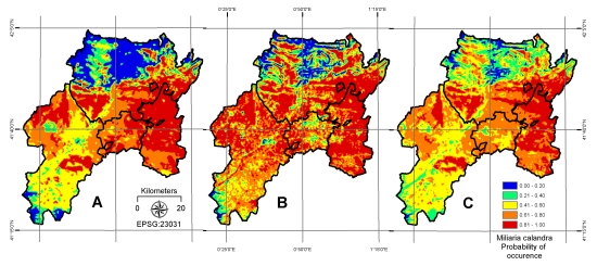
Integrating Open Access Geospatial Data to Map the Habitat Suitability of the Declining Corn Bunting (Miliaria calandra)


Abstract
1. Introduction
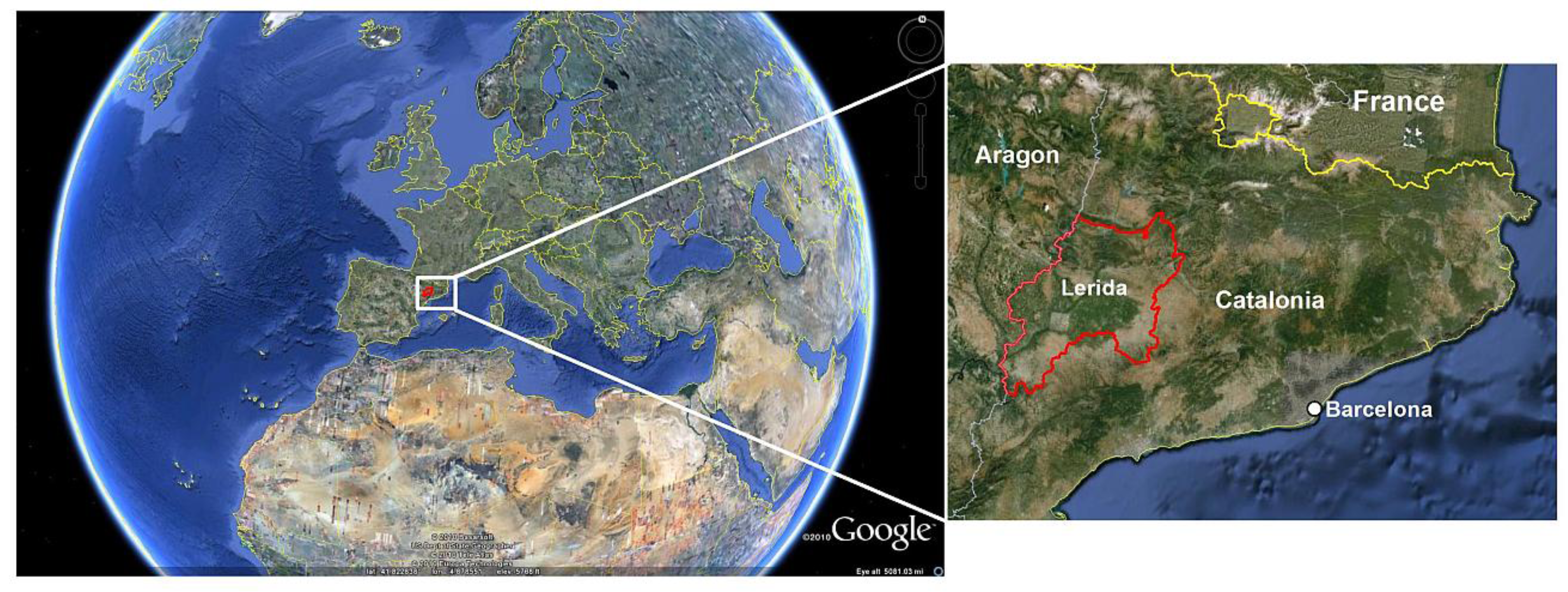
2. Study Area

3. Materials and Methods
3.1. Open Access Geospatial Data

| Band | Spatial Resolution (m) | Lower Limit (µm) | Upper Limit (µm) | Designation | Optical Domain |
|---|---|---|---|---|---|
| 1 | 30 | 0.45 | 0.52 | Blue | Visible |
| 2 | 30 | 0.52 | 0.60 | Green | Visible |
| 3 | 30 | 0.63 | 0.69 | Red | Visible |
| 4 | 30 | 0.77 | 0.90 | Near Infrared | Infrared |
| 5 | 30 | 1.55 | 1.75 | Shortwave Infrared | Infrared |
| 6 | 60 | 10.40 | 12.50 | Thermal Infrared | Thermal |
| 7 | 30 | 2.09 | 2.35 | Shortwave Infrared | Infrared |
3.2. Explanatory Variables
| CLC2000 Classes | Area in km2 | Percent of Study Area |
|---|---|---|
| Permanently irrigated land | 1,440 | 26.48 |
| Non-irrigated arable land | 1,182 | 21.74 |
| Complex cultivation patterns | 923 | 16.97 |
| Fruit trees and berry plantations | 452 | 8.31 |
| Agricultural with natural vegetation | 396 | 7.27 |
| Transitional woodland-shrub | 331 | 6.08 |
| Sclerophyllous vegetation | 240 | 4.41 |
| Broad-leaved forest | 240 | 4.41 |
| Mixed forest | 56 | 1.04 |
| Water bodies | 50 | 0.92 |
| Continuous urban fabric | 38 | 0.69 |
| Vineyards | 26 | 0.48 |
| Water courses | 16 | 0.29 |
| Olive groves | 12 | 0.23 |
| Natural grasslands | 8 | 0.15 |
| Industrial or commercial units | 8 | 0.14 |
| Discontinuous urban fabric | 5 | 0.10 |
| Mineral extraction sites | 5 | 0.09 |
| Bare rocks | 3 | 0.05 |
| Inland marshes | 2 | 0.04 |
| Annual crops associated with perm crops | 2 | 0.03 |
| Pastures | 1 | 0.02 |
| Rice fields | 1 | 0.02 |
| Sparsely vegetated areas | 1 | 0.02 |
| Sport and leisure facilities | 0.5 | 0.01 |
| Construction sites | 0.2 | 0.004 |
| Variable | Coefficient | S.E. | Wald | p | |
|---|---|---|---|---|---|
| Landsat ETM+ | Standard deviation ETM+1: BAND1SD | −1.106 | 0.636 | −1.74 | 0.009 |
| Standard deviation ETM+2: BAND2SD | 0.017 | 0.027 | 0.63 | 0.523 | |
| Standard deviation ETM+3: BAND3SD | 0.027 | 0.016 | 1.69 | 0.103 | |
| Standard deviation ETM+4: BAND4SD | 0.012 | 0.019 | 0.63 | 0.523 | |
| Standard deviation ETM+5: BAND5SD | −0.005 | 0.018 | −0.28 | 0.763 | |
| Standard deviation ETM+7: BAND7SD | 0.022 | 0.018 | 1.22 | 0.209 | |
| Coefficient of variation ETM+1: BAND1CV | 1.172 | 1.240 | 0.95 | 0.344 | |
| Coefficient of variation ETM+2: BAND2CV | 1.397 | 1.225 | 1.14 | 0.253 | |
| Coefficient of variation ETM+3: BAND3CV | 1.922 | 0.934 | 2.06 | 0.039 | |
| Coefficient of variation ETM+4: BAND4CV | −1.003 | 1.005 | −1.00 | 0.318 | |
| Coefficient of variation ETM+5: BAND5CV | −2.994 | 1.049 | −2.85 | 0.003 | |
| Coefficient of variation ETM+7: BAND7CV | 0.995 | 0.964 | 1.03 | 0.302 | |
| LST (°C) | 2.182 | 1.052 | 2.07 | <0.001 | |
| MSAVI | 2.311 | 0.677 | 3.41 | <0.001 | |
| SRTM | Digital elevation model: DEM (meters) | −0.001 | 0.007 | −0.15 | 0.022 |
| Slope: SLOPE (degrees) | −0.252 | 0.047 | −5.36 | 0.001 | |
| Aspect: ASPECT | −0.001 | 0.001 | −1.00 | 0.311 | |
| CLC2000 | Agricultural with natural vegetation: PANV * | −0.522 | 0.775 | −0.67 | 0.500 |
| Broad-leaved forest: BLF * | −2.453 | 0.895 | −2.74 | 0.206 | |
| Complex cultivation patterns: CCP * | −0.393 | 0.390 | −1.01 | 0.314 | |
| Fruit trees and berry plantations: FTBP * | −0.479 | 0.460 | −1.04 | 0.298 | |
| Non-irrigated arable land: NIAL * | 2.694 | 0.594 | 4.54 | <0.001 | |
| Permanently irrigated land: PIL * | 1.139 | 0.397 | 2.87 | 0.004 | |
| Sclerophyllous vegetation: SVEG * | −0.449 | 0.798 | −0.56 | 0.573 | |
| Transitional woodland-shrub: TWS * | −2.469 | 0.722 | −3.42 | 0.600 | |
| Distance to wet areas: WETDIST (meters) | 7.69e−5 | 1.95e−05 | 3.94 | <0.001 | |
| Distance to human activity: HUMDIST (meters) | −1.26e−04 | 3.74e−05 | −3.37 | <0.001 |
3.2.1. Satellite Image Texture (ETM+)
3.2.2. Vegetation Index (ETM+)
3.2.3. Land Surface Temperature (ETM+)
3.2.4. Landscape Metrics (CLC2000)
3.2.5. Topography (SRTM)
3.3. Open Access Bird Data

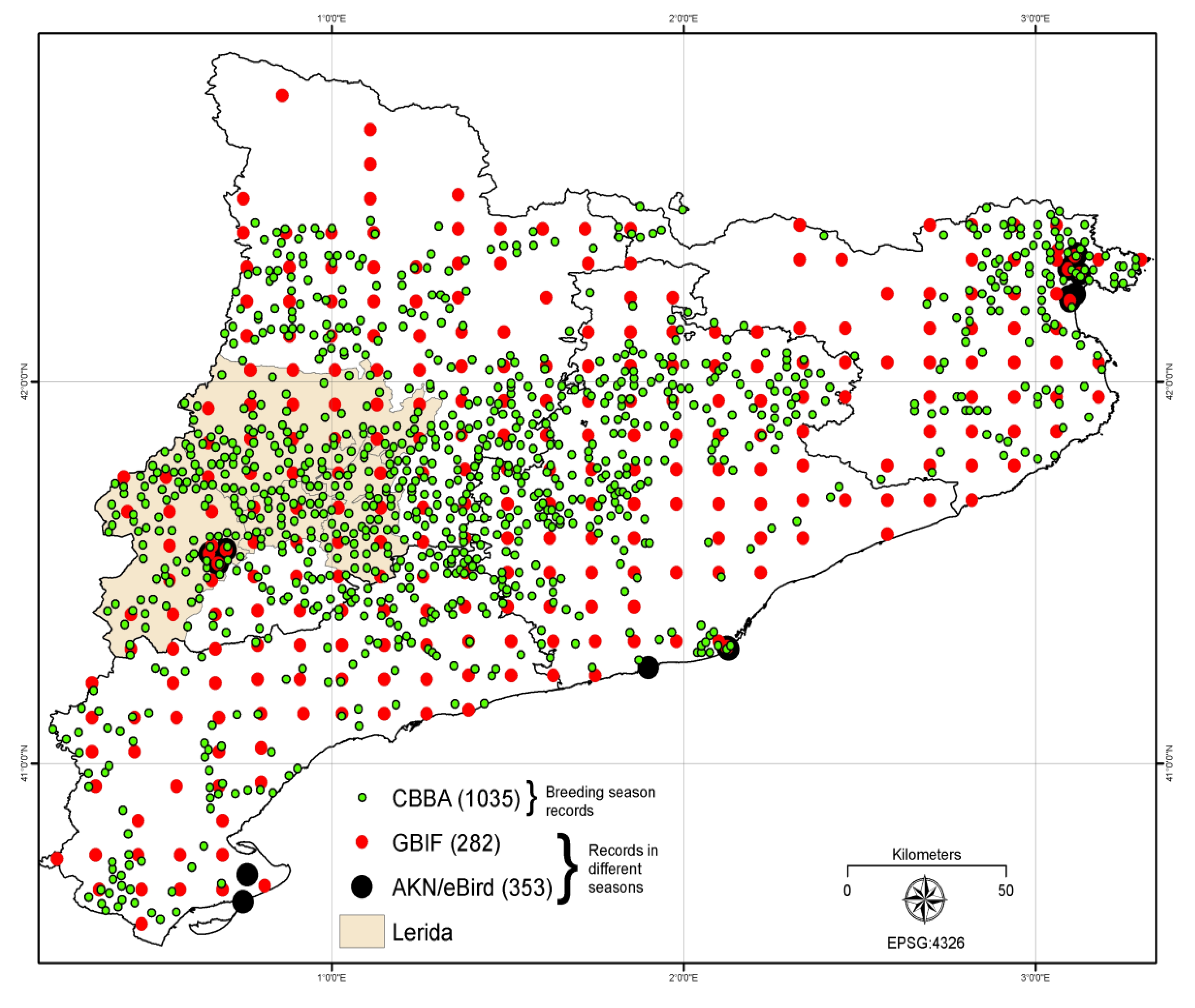
Data from the Catalan Breeding Bird Atlas
3.4. Free and Open Source Geospatial Software
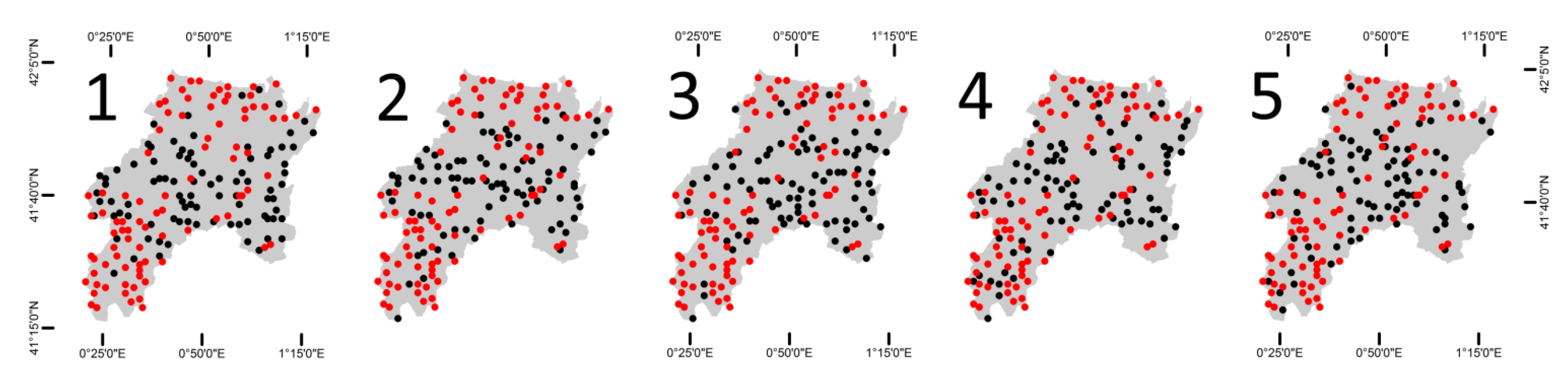
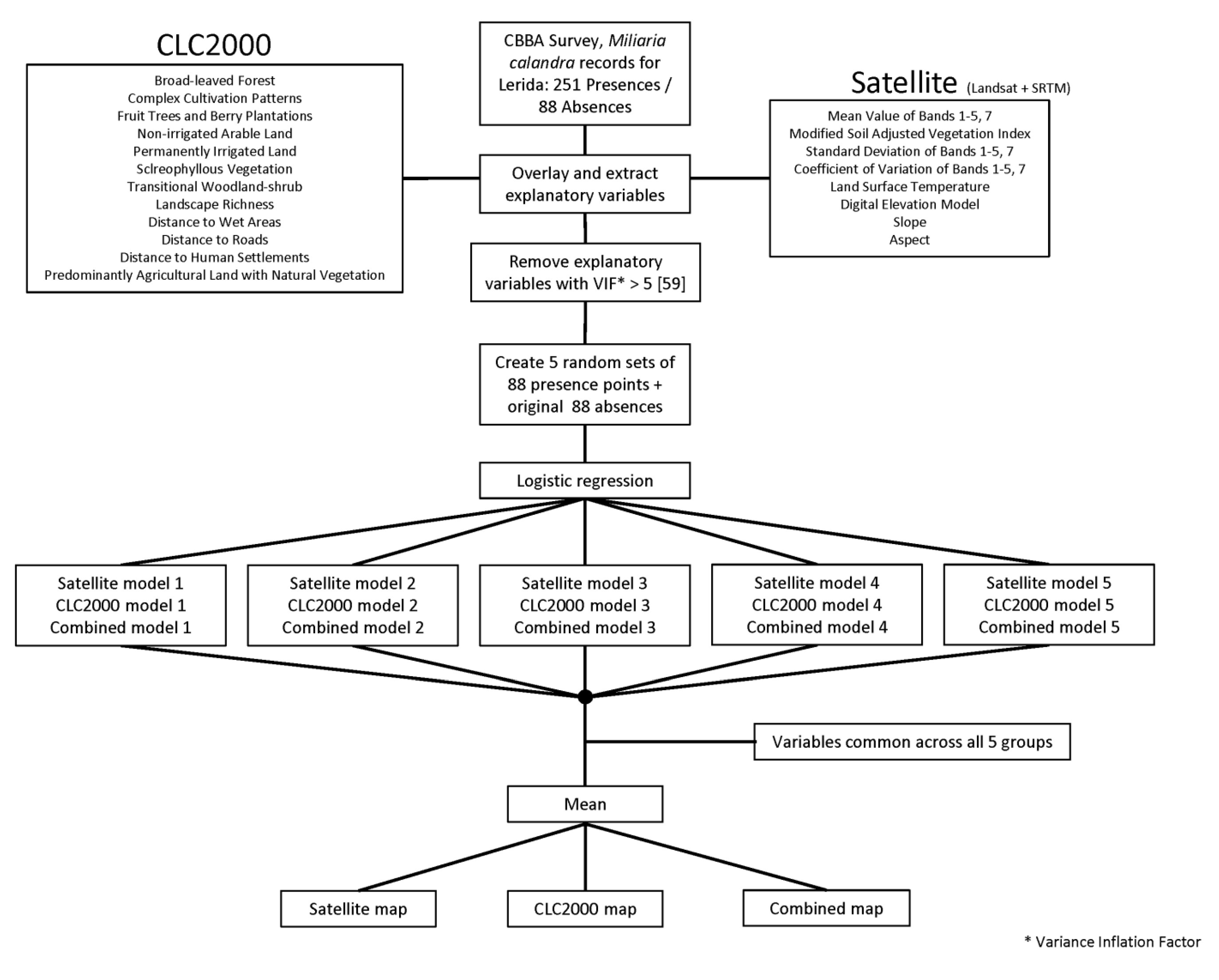
3.5. Modeling


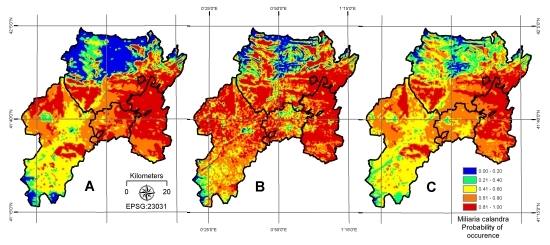
4. Results
| Variable | Coefficient | S.E. | Wald | p |
|---|---|---|---|---|
| (Intercept) | −0.703 | 0.456 | −1.542 | 0.123 |
| PANV | 1.207 | 0.861 | 1.402 | 0.161 |
| CCP | 1.136 | 0.539 | 2.108 | 0.035 |
| FTBP | 1.291 | 0.613 | 2.106 | 0.035 |
| NIAL | 4.032 | 0.721 | 5.592 | <0.001 |
| PIL | 2.395 | 0.557 | 4.300 | 0.002 |
| SVEG | 1.924 | 0.976 | 1.971 | 0.048 |
| HUMDIST | −8e−05 * | 5e05 ** | −1.6E−10 | 0.091 |
| WETDIST | −5e−05 | 2e05 | −2.501 | 0.016 |
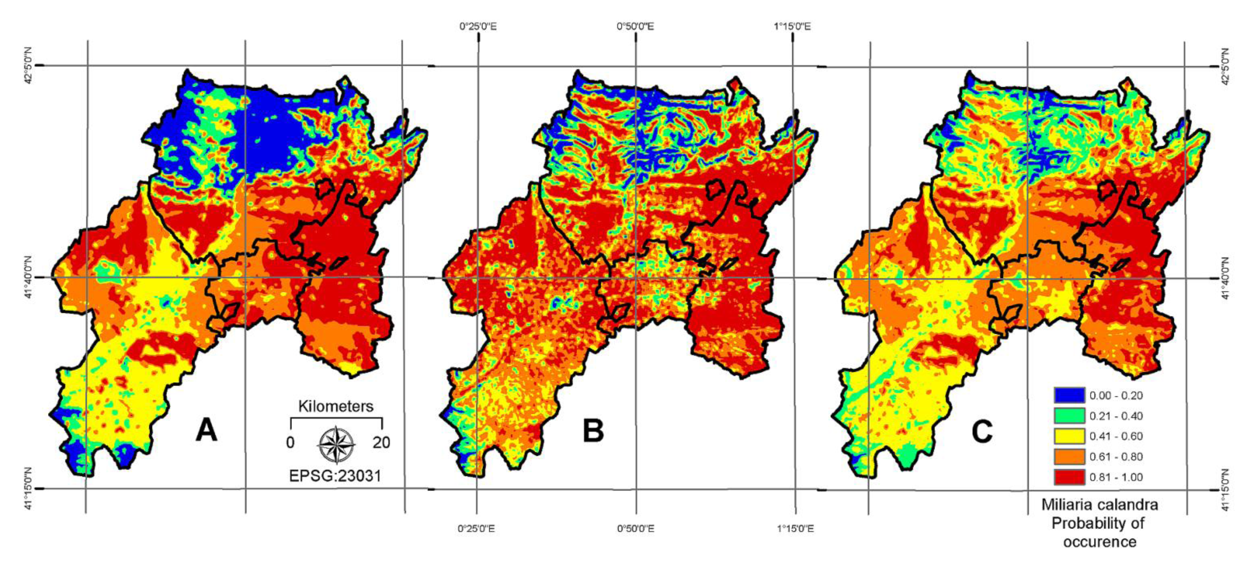
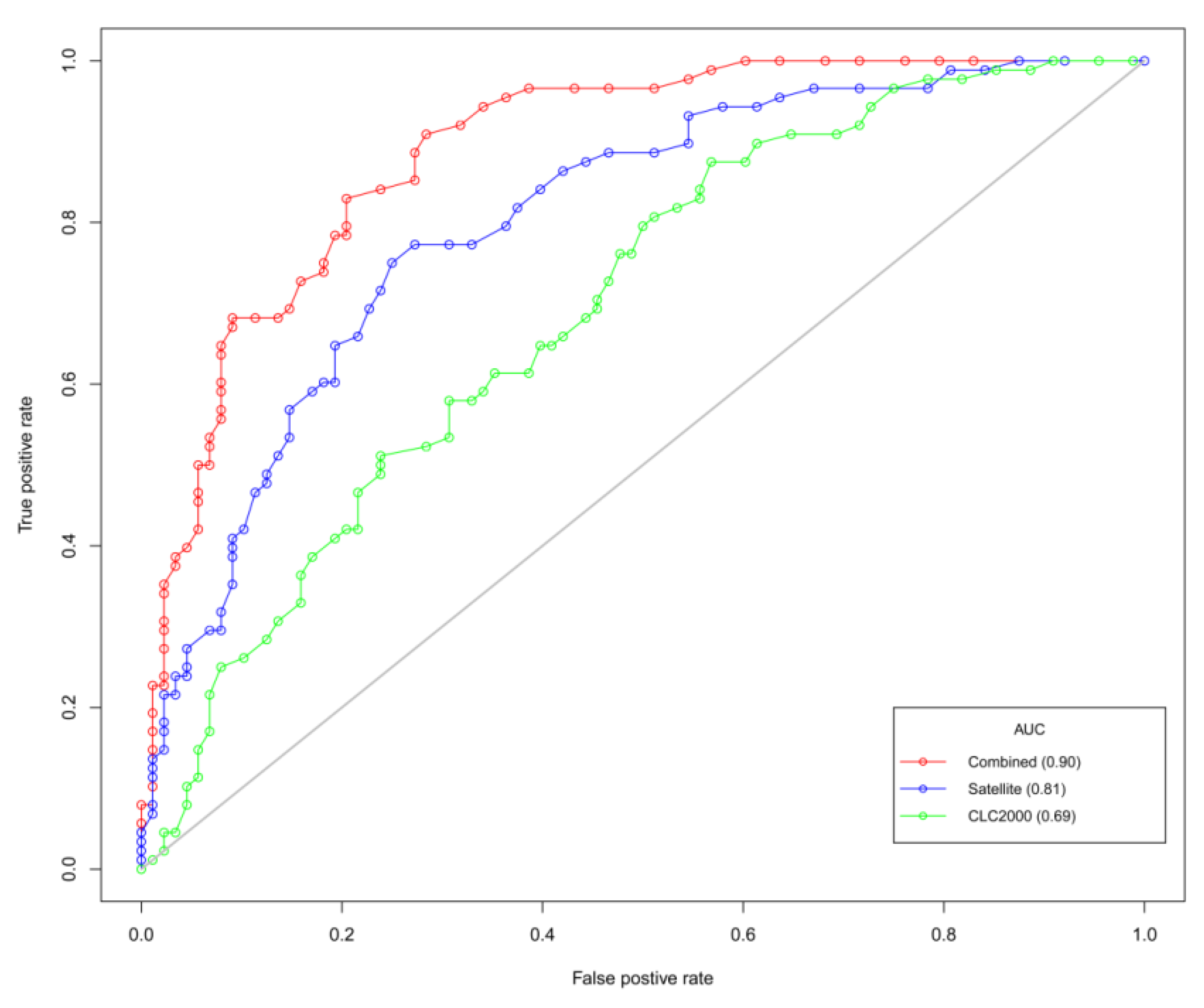
| AIC | 355 | AUC | 0.69 |
| Variable | Coefficient | S.E. | Wald | p |
|---|---|---|---|---|
| (Intercept) | −12.741 | 3.004 | −4.241 | 0.002 |
| MSAVI | 3.432 | 0.979 | 3.506 | <0.001 |
| BAND1SD | −0.093 | 0.056 | −1.661 | 0.097 |
| BAND5CV | 5.255 | 1.735 | 3.029 | 0.002 |
| DEM | 0.003 | 0.001 | 3.001 | 0.011 |
| SLOPE | −0.301 | 0.075 | −4.013 | <0.001 |
| LST | 0.286 | 0.071 | 4.028 | <0.001 |
| AIC | 310 | AUC | 0.81 |
| Variable | Coefficient | S.E. | Wald | p |
|---|---|---|---|---|
| (Intercept) | −12.16 | 3.495 | −3.479 | 0.005 |
| MSAVI (A) | 3.287 | 0.883 | 3.723 | 0.002 |
| LST (B) | 0.328 | 0.095 | 3.453 | <0.001 |
| BAND5CV (C) | 4.600 | 1.856 | 2.478 | 0.013 |
| BAND1SD (D) | −0.141 | 0.060 | −2.350 | 0.019 |
| SLOPE (E) | −0.211 | 0.082 | −2.573 | 0.010 |
| BLF (F) | −0.002 | 0.001 | −2.001 | 0.051 |
| NIAL (G) | 1.975 | 0.613 | 3.222 | 0.001 |
| PIL (H) | 1.658 | 0.685 | 2.420 | 0.015 |
| HUMDIST (I) | −9e−05 | 5e−05 | −1.801 | 0.048 |
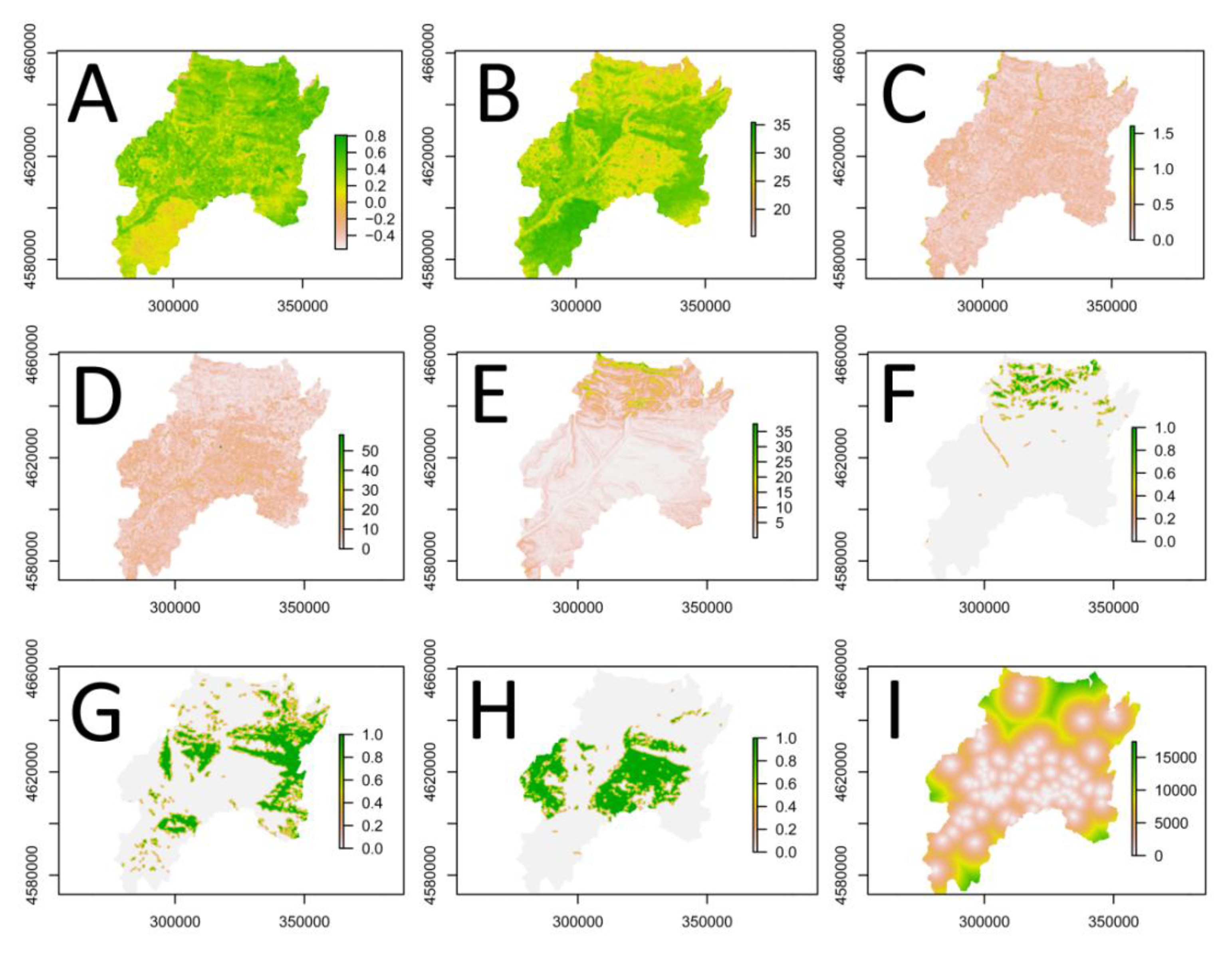
| AIC | 285 | AUC | 0.90 |


5. Discussion
6. Conclusion
Acknowledgments
Conflict of Interest
References
- Birdlife-International. In Birds in the European Union: A Status Assessment, 1st ed.; Birdlife International: Wageningen, The Netherlands, 2004.
- Deceuninck, B. The Corncrake (Crex crex) in France; Schaeffer, N., Mammen, U., Eds.; International Corncrake Workshop: Hilpoltstein, Germany, 1998. [Google Scholar]
- De Leo, G.A.; Focardi, S.; Gatto, M.; Cattadori, I.M. The decline of the grey partridge in Europe: Comparing demographies in traditional and modern agricultural landscapes. Ecol. Model. 2004, 177, 313–335. [Google Scholar] [CrossRef]
- Tucker, G.M.; Heath, M.F. Birds in Europe: Their Conservation Status; BirdLife International: Cambridge, UK, 1994. [Google Scholar]
- Vepsäläinen, V.; Pakkala, T.; Piha, M.; Tiainen, J. Population crash of the ortolan bunting Emberiza hortulana in agricultural landscapes of southern Finland. Ann. Zoologici. Fennici 2005, 42, 91–107. [Google Scholar]
- Kosicki, J.Z.; Chylarecki, P. Habitat selection of the Ortolan bunting Emberiza hortulana in Poland: Predictions from large-scale habitat elements. Ecol. Res. 2012, 27, 347–355. [Google Scholar] [CrossRef]
- Evans, A.; Smith, K. Habitat selection of Cirl Buntings Emberiza cirlus wintering in Britain. Bird Study 1994, 41, 81–87. [Google Scholar] [CrossRef]
- Wotton, S.R.; Langston, R.H.W.; Gibbons, D.W.; Pierce, A.J. The status of the Cirl Bunting Emberiza cirlus in the UK and the Channel Islands in 1998. Bird Study 2000, 47, 138–146. [Google Scholar] [CrossRef]
- Stoate, C.; Moreby, S.J.; Szczur, J. Breeding ecology of farmland Yellowhammers Emberiza citrinella. Bird Study 1998, 45, 109–121. [Google Scholar] [CrossRef]
- Golawski, A.; Dombrowski, A. Habitat use of Yellowhammers Emberiza citrinella, Ortolan Buntings E. hortulana, and Corn Buntings Miliaria calandra in farmland of east-central Poland. Ornis Fennica 2002, 79, 164–172. [Google Scholar]
- Wretenberg, J.; Lindström, Å.; Svensson, S.; Pärt, T. Linking agricultural policies to population trends of Swedish farmland birds in different agricultural regions. J. Appl. Ecol. 2007, 44, 933–941. [Google Scholar] [CrossRef]
- Whittingham, M.J.; Swetnam, R.D.; Wilson, J.D.; Chamberlain, D.E.; Freckleton, R.P. Habitat selection by yellowhammers Emberiza citrinella on lowland farmland at two spatial scales: Implications for conservation management. J. Appl. Ecol. 2005, 42, 270–280. [Google Scholar] [CrossRef]
- Brickle, N.; Harper, D.; Aebischer, N.; Cockayne, S. Effects of agricultural intensification on the breeding success of corn buntings Miliaria calandra. J. Appl. Ecol. 2000, 37, 742–755. [Google Scholar] [CrossRef]
- Orlowski, G. Endangered and declining bird species of abandoned farmland in south-western Poland. Agric. Ecosyst. Environ. 2005, 111, 231–236. [Google Scholar] [CrossRef]
- Eisloeffel, F. The Corn Bunting (Miliaria calandra) in South-West Germany: Population Decline and Habitat Requirements. In The Ecology and Conservation of Corn Buntings (Miliaria calandra); Donald, P.F., Aebischer, N.J., Eds.; Joint Nature Conservation Committee: Peterborough, UK, 1997; pp. 170–173. [Google Scholar]
- Taylor, A.J.; O’Halloran, J. The decline of the Corn Bunting Miliaria calandra, in the Republic of Ireland. Biology Environ. Proc. Royal Irish Acad. 2002, 102, 165–175. [Google Scholar] [CrossRef]
- Donald, P.F.; Green, R.E.; Heath, M.F. Agricultural intensification and the collapse of Europe’s farmland bird populations. Proc. Royal Soc. B 2001, 268, 25–29. [Google Scholar] [CrossRef]
- Fuller, R.M.; Devereux, B.J.; Gillings, S.; Amable, G.S. Indices of bird-habitat preference from field surveys of birds and remote sensing of land cover: A study of south-eastern England with wider implications for conservation and biodiversity assessment. Global Ecol. Biogeogr. 2005, 14, 223–239. [Google Scholar] [CrossRef]
- Kuczynski, L.; Antczak, M.; Czechowski, P.; Grzybek, J.; Jerzak, L.; Zablocki, P.; Tryjanowski, P. A large scale survey of the great grey shrike Lanius excubitor in Poland: Breeding densities, habitat use and population trends. Ann. Zoologici Fennici 2010, 47, 67–78. [Google Scholar] [CrossRef]
- Diaz, M.; Telleria, J.L. Habitat Selection and Distribution Trends of Corn Buntings in the Iberian Peninsula. In The Ecology and Conservation of Corn Buntings Miliaria Calandra; Donald, P., Aebischer, N.J., Eds.; JNCC: Peterborough, UK, 1997; pp. 151–161. [Google Scholar]
- Stoate, C.; Borralho, R.; Araujo, M. Factors affecting corn bunting Miliaria calandra abundance in a Portuguese agricultural landscape. Agric. Ecosyst. Environ. 2000, 77, 219–226. [Google Scholar] [CrossRef]
- Brambilla, M.; Guidali, F.; Negri, I. Breeding-season habitat associations of the declining Corn Bunting Emberiza calandra—A potential indicator of the overall bunting richness. Ornis Fennica 2009, 86, 41–50. [Google Scholar]
- Brotons, L.; Manosa, S.; Estrada, J. Modelling the effects of irrigation schemes on the distribution of steppe birds in Mediterranean farmland. Biodivers. Conserv. 2004, 13, 1039–1058. [Google Scholar] [CrossRef]
- Moreno-Mateos, D.; Pedrocchi, C.; Comin, F.A. Avian communities’ presence in recently created agricultural wetlands in irrigated landscapes of semi-arid areas. Biodivers. Conserv. 2009, 18, 811–828. [Google Scholar] [CrossRef]
- Reeves, H.M.; Cooch, F.G.; Munro, R.E. Monitoring arctic habitat and goose production by satellite imagery. J. Wildl. Manag. 1976, 40, 532–541. [Google Scholar] [CrossRef]
- Cannon, R.W.; Knopf, F.L.; Pettinger, L.R. Use of Landsat data to evaluate Lesser Prairie Chicken habitats in western Oklahoma. J. Wildl. Manag. 1982, 46, 915–922. [Google Scholar] [CrossRef]
- Lauver, C.L.; Whistler, J. A hierarchical classification of Landsat TM imagery to identify natural grassland areas and rare species habitat. Photogramm. Eng. Remote Sens. 1993, 59, 627–634. [Google Scholar]
- Shirley, S.; Yang, Z.; Hutchinson, R.; Alexander, J.; McGarigal, K.; Betts, M. Species distribution modelling for the people: Unclassified landsat TM imagery predicts bird occurrence at fine resolutions. Divers. Distrib. 2013, 19, 855–866. [Google Scholar] [CrossRef]
- Houska, T.R.; Johnson, A.P. GloVis Ver. 8.17.1.; US Geological Survey General Information Product Series 137; Earth Resources Observation and Science (EROS) Center: Reston, VA, USA, 2012. [Google Scholar]
- Goslee, S.C. Analyzing remote sensing data in R: The Landsat package. J. Stat. Softw. 2011, 43, 1–25. [Google Scholar]
- R Development Core Team, R: A Language and Environment for Statistical Computing; R Foundation for Statistical Computing: Vienna, Austria, 2009.
- Rabus, B.; Eineder, M.; Roth, A.; Bamler, R. The shuttle radar topography mission—A new class of digital elevation models acquired by spaceborne radar. ISPRS J. Photogramm. Remote Sens. 2003, 57, 241–262. [Google Scholar] [CrossRef]
- Oliver, T.; Roy, D.B.; Hill, J.K.; Brereton, T.; Thomas, C.D. Heterogeneous landscapes promote population stability. Ecol. Lett. 2010, 13, 473–484. [Google Scholar] [CrossRef]
- Jarvis, A.; Reuter, H.; Nelson, A.; Guevara, E. Hole-Filled SRTM for the Globe Version 4. In CGIAR-CSI SRTM 90 m Database. Available online: http://srtm.csi.cgiar.org (accessed on 12 November 2009).
- Büttner, G.; Feranec, J.; Jaffrain, G.; Mari, L.; Maucha, G.; Soukup, T. The CORINE land cover 2000 project. EARSeL eProc. 2004, 3, 331–346. [Google Scholar]
- Saveraid, E.H.; Debinski, D.M.; Kindscher, K.; Jakubauskas, M.E. A comparison of satellite data and landscape variables in predicting bird species occurrences in the Greater Yellowstone Ecosystem, USA. Landsc. Ecol. 2001, 16, 71–83. [Google Scholar] [CrossRef]
- St-Louis, V.; Pidgeon, A.M.; Clayton, M.K.; Locke, B.A.; Bash, D.; Radeloff, V.C. Satellite image texture and a vegetation index predict avian biodiversity in the Chihuahuan Desert of New Mexico. Ecography 2009, 32, 468–480. [Google Scholar] [CrossRef]
- Horning, N.; Robinson, J.; Sterling, E.; Turner, W.; Spector, S. Remote Sensing for Ecology and Conservation; Oxford University Press: Oxford, UK, 2010; pp. 108–111. [Google Scholar]
- Qi, J.; Chehbouni, A.; Huete, A.R.; Kerr, Y.H.; Sorooshian, S. A modified soil adjusted vegetation index. Remote Sens. Environ. 1994, 48, 119–126. [Google Scholar] [CrossRef]
- Lambin, E.F.; Ehrlich, D. The surface temperature-vegetation index space for land cover and land-cover change analysis. Int. J. Remote Sens. 1996, 17, 463–487. [Google Scholar] [CrossRef]
- Quattrochi, D.A.; Luvall, J.C. Thermal infrared remote sensing for analysis of landscape ecological processes: Methods and applications. Landsc. Ecol. 1999, 14, 577–598. [Google Scholar] [CrossRef]
- Kerr, J.T.; Ostrovsky, M. From space to species: Ecological applications for remote sensing. Trends Ecol. Evol. 2003, 18, 299–305. [Google Scholar] [CrossRef]
- Sobrino, J.A.; Jiménez-Muñoz, J.C.; Paolini, L. Land surface temperature retrieval from Landsat TM 5. Remote Sens. Environ. 2004, 90, 434–440. [Google Scholar] [CrossRef]
- NASA, Band 6 Conversion to Temperature. In Landsat 7 Science Data Users Handbook; ational Aeronautics and Space Administration: Greenbelt, MD, USA, 2009; pp. 117–120.
- Gustafson, E.J.; Parker, G.R.; Backs, S.E. Evaluating spatial pattern of wildlife habitat: A case study of the wild Turkey (Meleagris gallopavo). Am. Midl. Nat. 1994, 131, 24–33. [Google Scholar] [CrossRef]
- Fauth, P.T.; Gustafson, E.J.; Rabenold, K.N. Using landscape metrics to model source habitat for Neotropical migrants in the Midwestern US. Landsc. Ecol. 2000, 15, 621–631. [Google Scholar] [CrossRef]
- De Smith, M.J.; Goodchild, M.F.; Longley, P.A. Grid-based Statistics. In Geospatial Analysis: A Comprehensive Guide to Principles, Techniques and Software Tools; Troubador Publishing Ltd.: Leicester, UK, 2007; pp. 194–199. [Google Scholar]
- Vander Haegen, W.M.; Dobler, F.C.; Pierce, D.J. Shrubsteppe bird response to habitat and landscape variables in Eastern Washington, USA. Conserv. Biol. 2000, 14, 1145–1160. [Google Scholar] [CrossRef]
- Edwards, J.L.; Lane, M.A.; Nielsen, E.S. Interoperability of biodiversity databases: Biodiversity information on every desktop. Science 2000, 289, 2312–2314. [Google Scholar] [CrossRef]
- Sullivan, B.L.; Wood, C.L.; Iliff, M.J.; Bonney, R.E.; Fink, D.; Kelling, S. eBird: A citizen-based bird observation network in the biological sciences. Biol. Conser. 2009, 142, 2282–2292. [Google Scholar] [CrossRef]
- Brotons, L.; Herrando, S.; Estrada, J.; Pedrocchi, V.; Martin, J.L. The Catalan Breeding Bird Atlas (CBBA): Methodological aspects and ecological implications. Revista Catalana d’Ornitologia 2008, 24, 118–137. [Google Scholar]
- Keitt, T.H.; Bivand, R.; Pebesma, E.; Rowlingson, B. Rgdal: Bindings for the Geospatial Data Abstraction Library. R Package Version 0.6–25. 2010. Available online: http://cran.r-project.org/web/packages/rgdal/index.html (accessed on 25 February 2010),.
- Lindsay, J. Whitebox Geospatial Analysis Tools; Department of Geography, University of Guelph: Guelph, Ontario, Canada, 2009. Available online: Available online: http://www.uoguelph.ca/~hydrogeo/ Whitebox/ (accessed on 29 December 2009).
- Cimmery, V. User Guide for SAGA. Version 2.0, 2007. Available online: http://saga-gis.org/ (accessed on 15 January 2010).
- Gagné, M. Moving to Ubuntu Linux; Pearson Education: Upper Saddle River, NJ, USA, 2006. [Google Scholar]
- Hosmer, D.W.; Lemeshow, S. Applied Logistic Regression, 2nd ed.; John Wiley & Sons, Inc.: New York, NY, USA, 2000. [Google Scholar]
- Akaike, H. Information Theory as an Extension of the Maximum Likelihood Principle; Petrov, B.N., Csaki, F., Eds.; Akademiai Kiado: Budapest, Hungary, 1973; pp. 267–281. [Google Scholar]
- Brauner, N.; Shacham, M. Role of range and precision of the independent variable in regression of data. Am. Inst. Chem. Eng. J. 1998, 44, 603–611. [Google Scholar] [CrossRef]
- O’Brien, R.M. A caution regarding rules of thumb for variance inflation factors. Qual. Quantity 2007, 41, 673–690. [Google Scholar] [CrossRef]
- Cohen, J. A coefficient of agreement for nominal scales. Educ. Psychological Meas. 1960, 20, 37–46. [Google Scholar] [CrossRef]
- Deleo, J.M. Receiver Operating Characteristic Laboratory (ROCLAB): Software for Developing Decision Strategies that Account for Uncertainity. In Proceedings of Second International Symposium on Uncertainty Modelling and Analysis, College Park, MD, 25–28 April 1993; IEEE Computer Society Press: College Park, MD, USA, 1993; pp. 318–325. [Google Scholar]
- Baraldi, A.; Parmiggiani, F. An investigation of the textural characteristics associated withgray level cooccurrence matrix statistical parameters. IEEE Trans. Geosci. Remote Sens. 1995, 33, 293–304. [Google Scholar] [CrossRef]
- Seoane, J.; Bustamante, J.; Diaz-Delgado, R. Competing roles for landscape, vegetation, topography and climate in predictive models of bird distribution. Ecol. Model. 2004, 171, 209–222. [Google Scholar] [CrossRef]
- Carrao, H.; Caetano, M. The Effect of Scale on Landscape Metrics. In Proceedings of International Symposium of Remote Sensing of the Environment, Buenos Aires, Argentina, 8–12 April 2002.
- Whited, D.; Galatowitsch, S.; Tester, J.R.; Schik, K.; Lehtinen, R.; Husveth, J. The importance of local and regional factors in predicting effective conservation: Planning strategies for wetland bird communities in agricultural and urban landscapes. Landsc. Urban. Plann. 2000, 49, 49–65. [Google Scholar] [CrossRef]
- Martí-Ragué, X.; Lescrauwaet, A.-K.; Borg, M.; Valls, M. Indicators Guidelines: To Adopt an Indicators-Based Approach to Evaluate Coastal Sustainable Development; Government of Catalonia: Barcelona, Spain, 2007. [Google Scholar]
- Seoane, J.; Bustamante, J.; Diaz-Delgado, R. Are existing vegetation maps adequate to predict bird distributions? Ecol. Model. 2004, 175, 137–149. [Google Scholar] [CrossRef]
Appendix
| Explanatory Variable | VIF |
|---|---|
| MSAVI | 3.820 |
| BAND1SD | 0.095 |
| BAND5CV | 2.850 |
| SLOPE | 0.165 |
| LST | 0.283 |
| BLF | 0.438 |
| NIAL | 2.061 |
| PIL | 2.051 |
| HUMDIST | 4.3e−5 |
© 2013 by the authors; licensee MDPI, Basel, Switzerland. This article is an open access article distributed under the terms and conditions of the Creative Commons Attribution license (http://creativecommons.org/licenses/by/3.0/).
Share and Cite
Abdi, A.M. Integrating Open Access Geospatial Data to Map the Habitat Suitability of the Declining Corn Bunting (Miliaria calandra). ISPRS Int. J. Geo-Inf. 2013, 2, 935-954. https://doi.org/10.3390/ijgi2040935
Abdi AM. Integrating Open Access Geospatial Data to Map the Habitat Suitability of the Declining Corn Bunting (Miliaria calandra). ISPRS International Journal of Geo-Information. 2013; 2(4):935-954. https://doi.org/10.3390/ijgi2040935
Chicago/Turabian StyleAbdi, Abdulhakim M. 2013. "Integrating Open Access Geospatial Data to Map the Habitat Suitability of the Declining Corn Bunting (Miliaria calandra)" ISPRS International Journal of Geo-Information 2, no. 4: 935-954. https://doi.org/10.3390/ijgi2040935
APA StyleAbdi, A. M. (2013). Integrating Open Access Geospatial Data to Map the Habitat Suitability of the Declining Corn Bunting (Miliaria calandra). ISPRS International Journal of Geo-Information, 2(4), 935-954. https://doi.org/10.3390/ijgi2040935