INTERLIS Language for Modelling Legal 3D Spaces and Physical 3D Objects by Including Formalized Implementable Constraints and Meaningful Code Lists

 , ,
, ,
Abstract
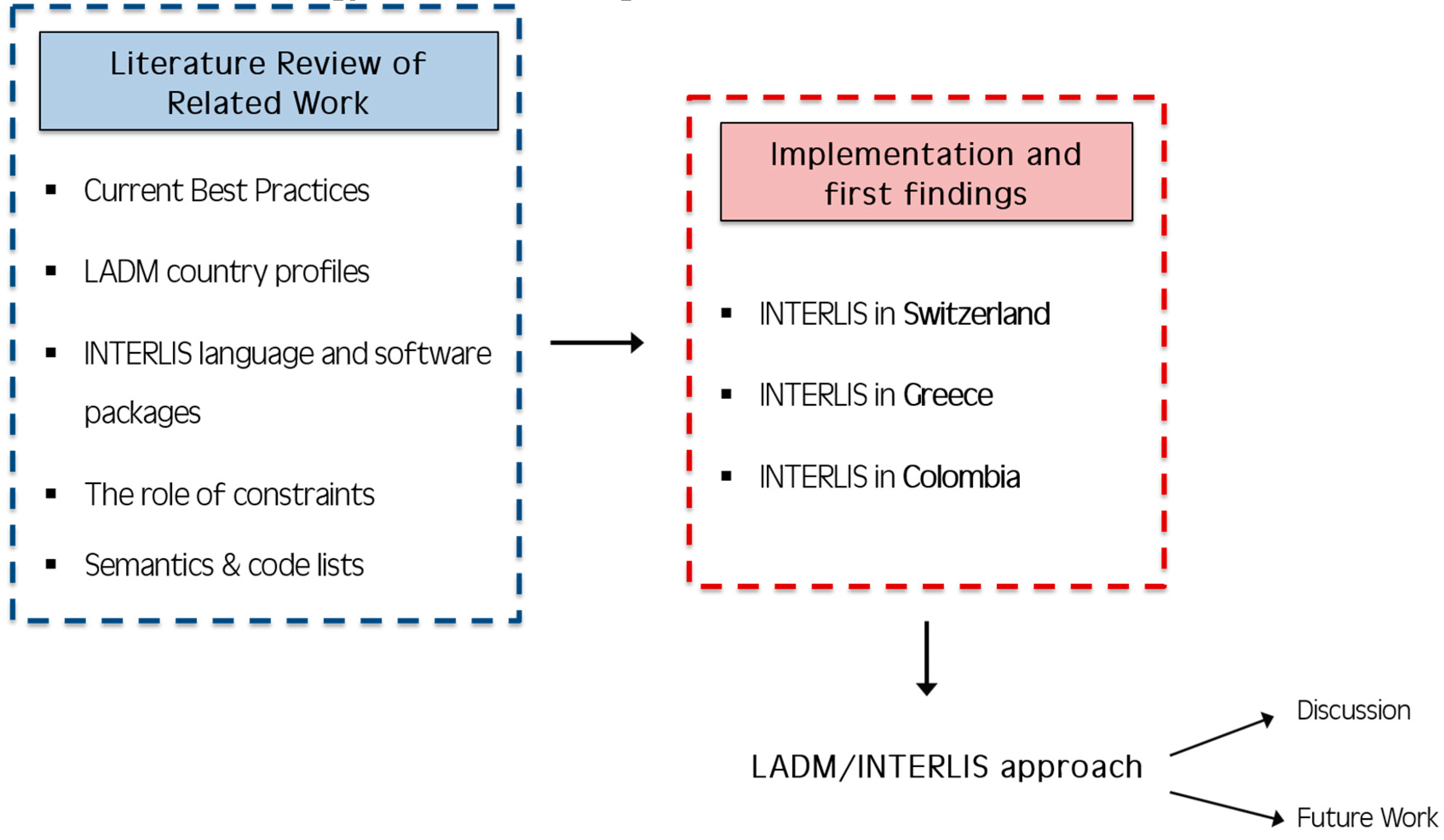
:1. Introduction
1.1. Background
1.2. Scope and Methodology
2. Related Work
2.1. The Third Dimension in the Field of Land Administration
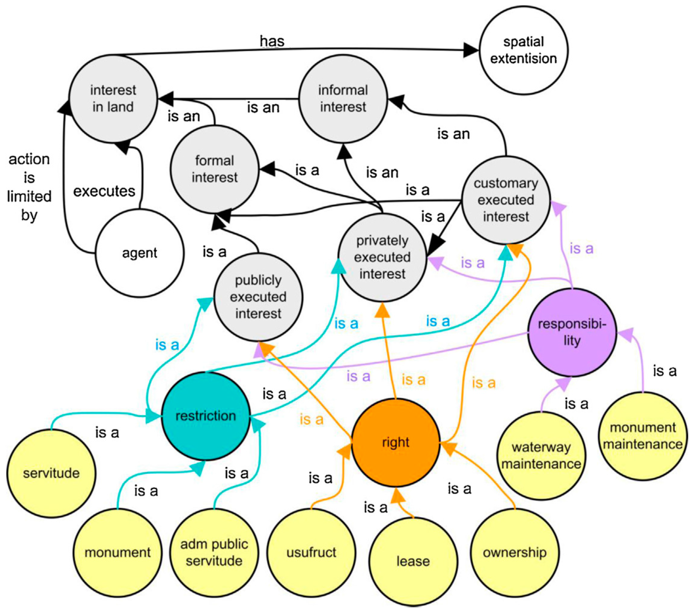
2.2. Legal and Physical Reality: Towards Integrated Approaches
- embedding the selected CityGML classes into a (broader) LADM framework; and
- introducing a link between both domain models (in an SDI or GII setting) using references between object instances.
2.3. LADM Implementations Based on Model-Driven Architecture Applications
2.4. The Role of Constraints in (Spatial) Data Modelling/Modelling (Geo-) Constraints
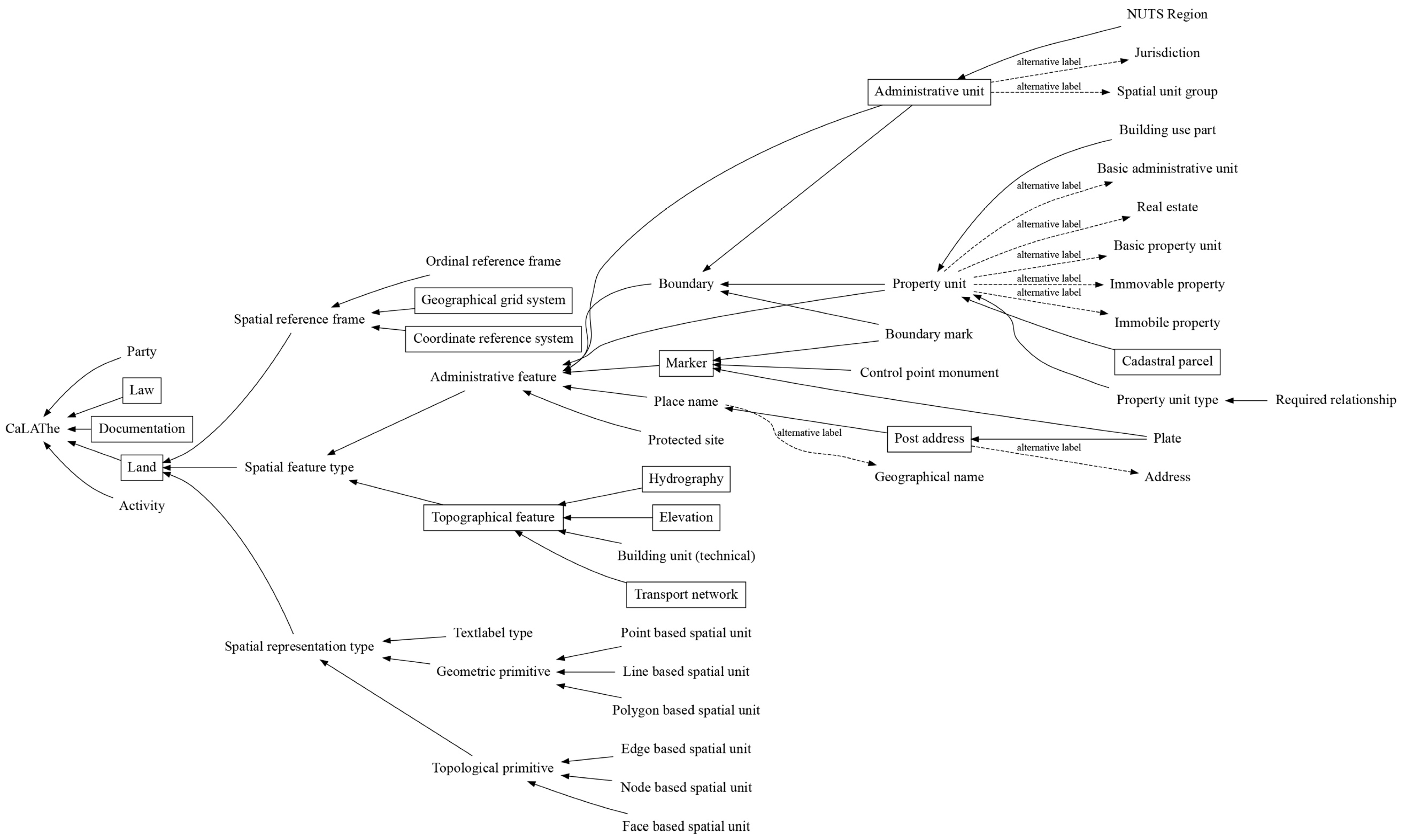
2.5. Semantics and the Meaning of Code Lists in the Land Administration Domain
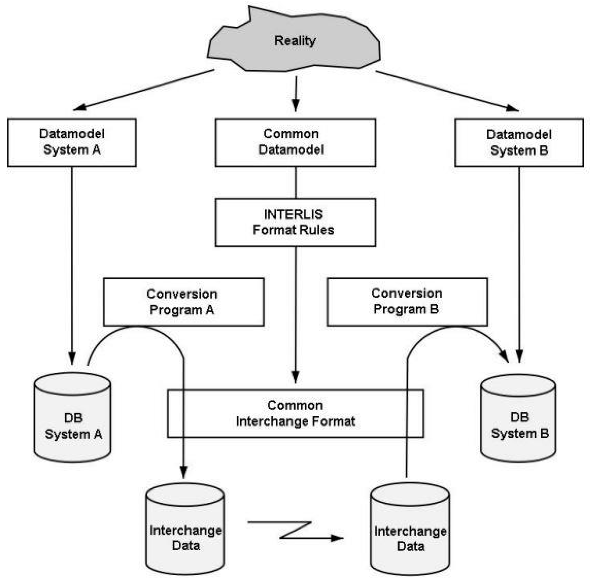
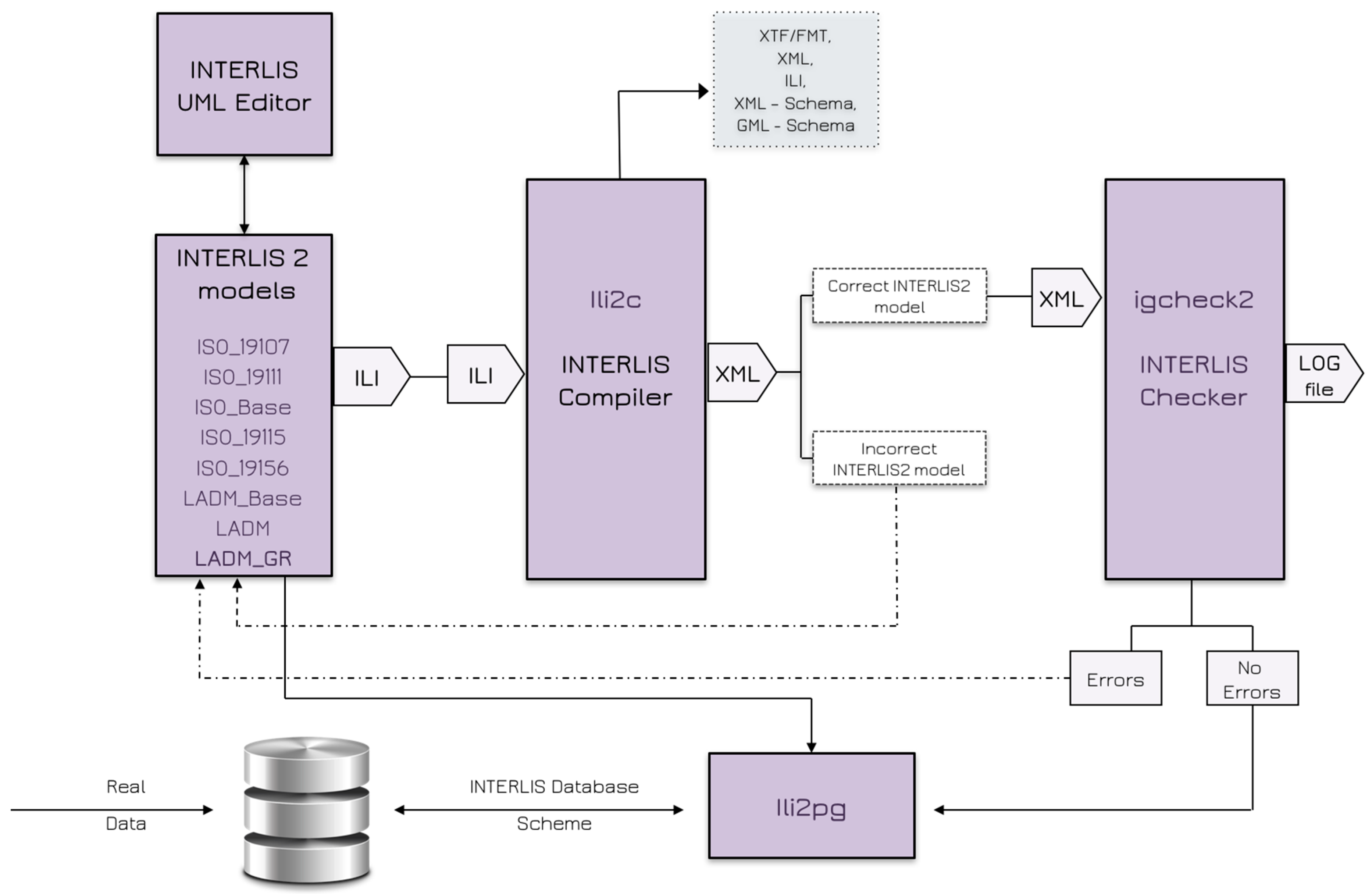
3. INTERLIS—Swiss Standard for Land Administration
3.1. UML/INTERLIS Editor
- graphical representation of existing INTERLIS data models as UML diagrams, providing a better understanding; and
- description of new models (e.g., LADM country profiles) with UML diagrams.
3.2. INTERLIS Compiler
3.3. INTERLIS Checker
3.4. INTERLIS Validator
3.5. INTERLIS Loader for Relational Databases
3.6. QGIS Project Generator Plugin
3.7. INTERLIS Reader/Writer to FME
4. LADM Implementation in INTERLIS
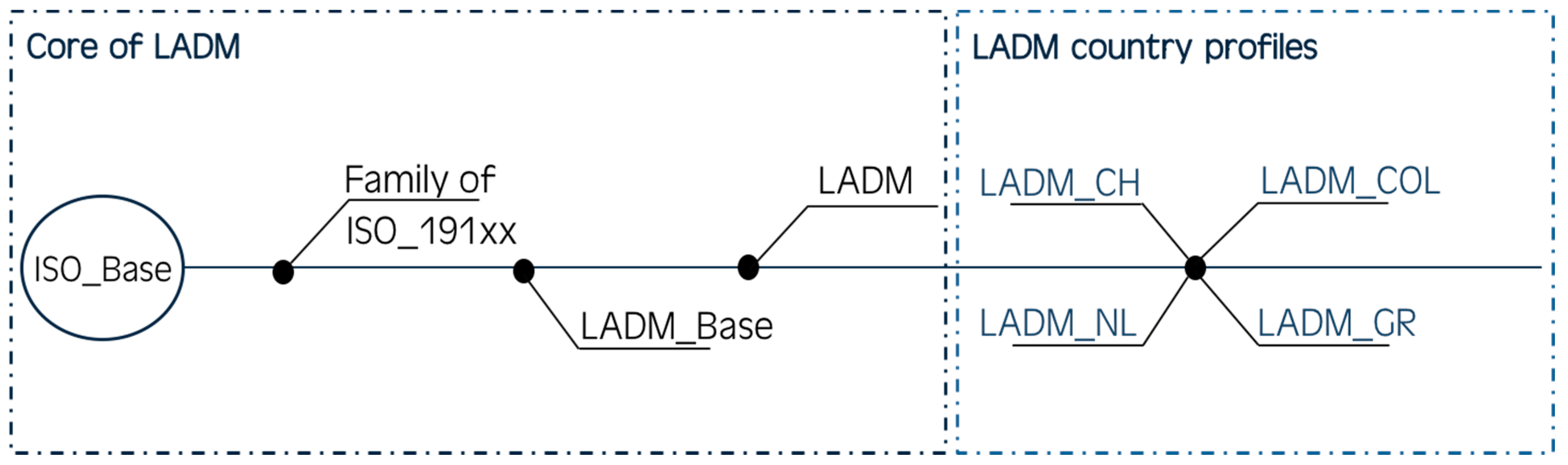
4.1. INTERLIS in Switzerland
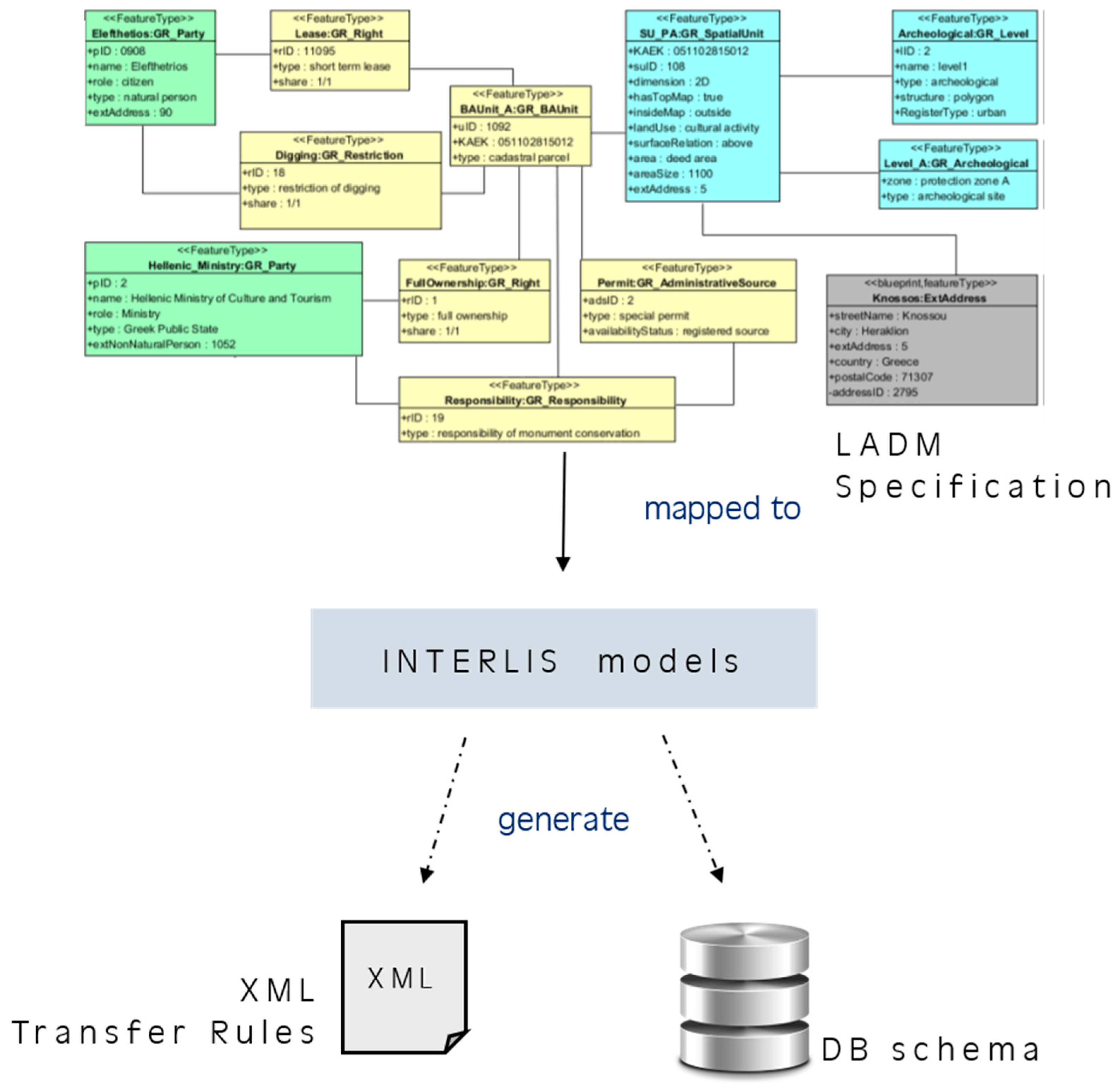
4.2. INTERLIS in Greece
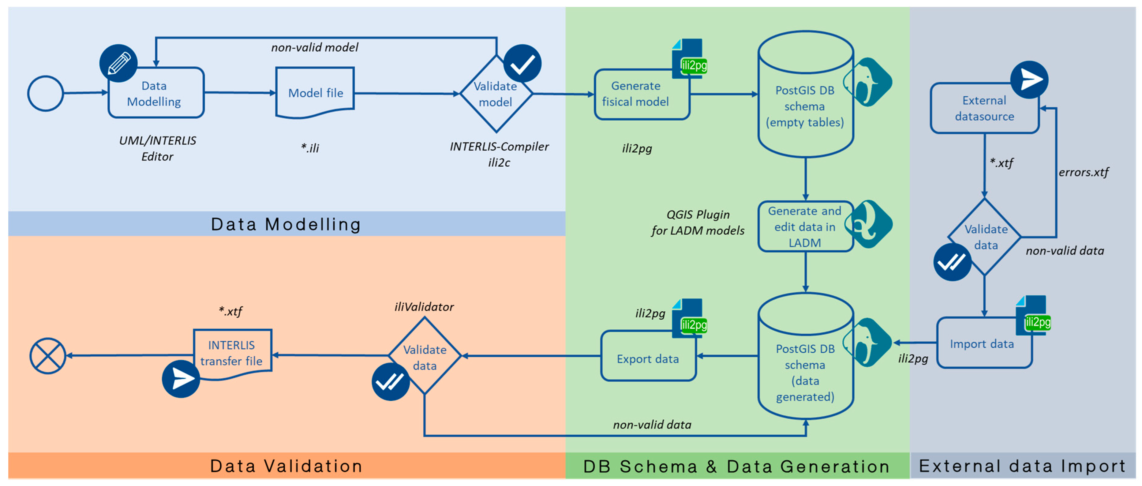
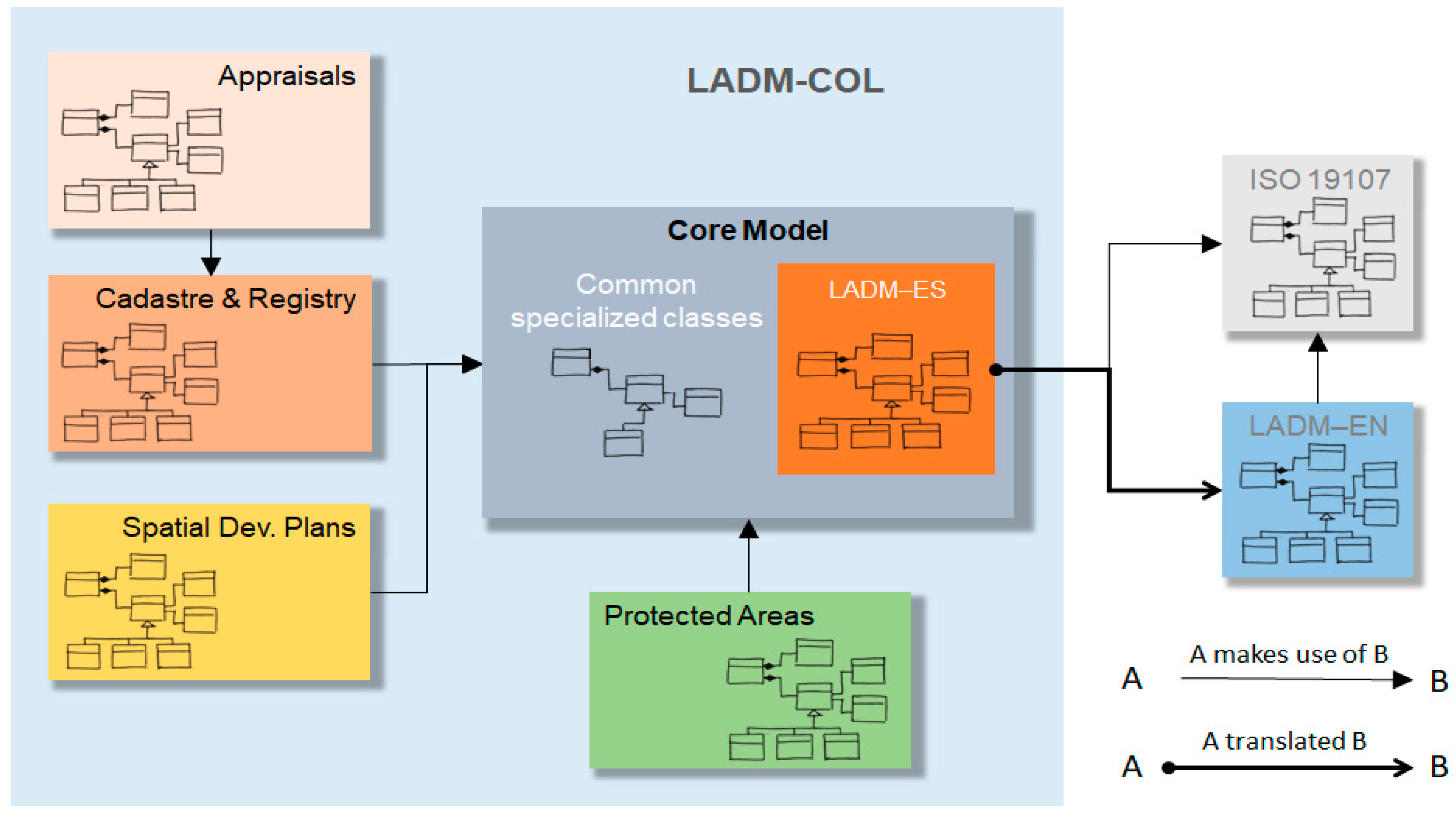
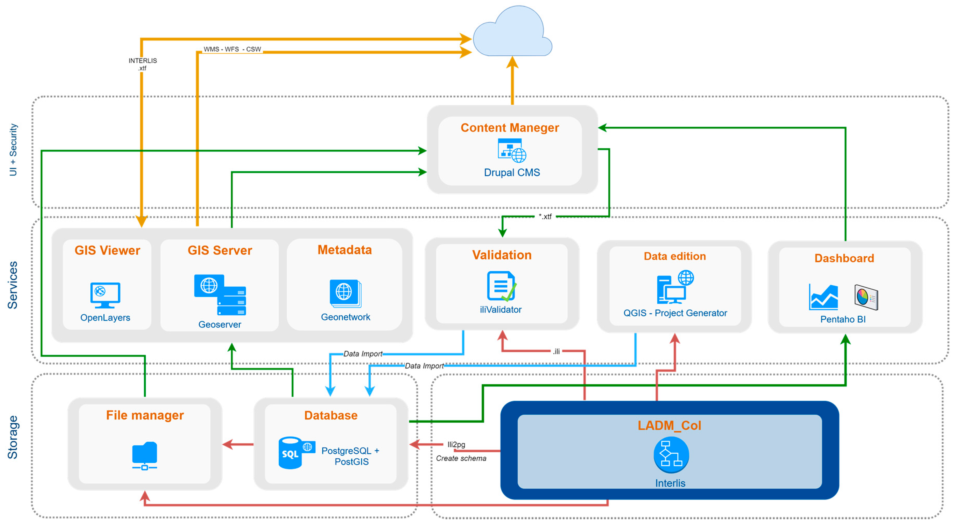
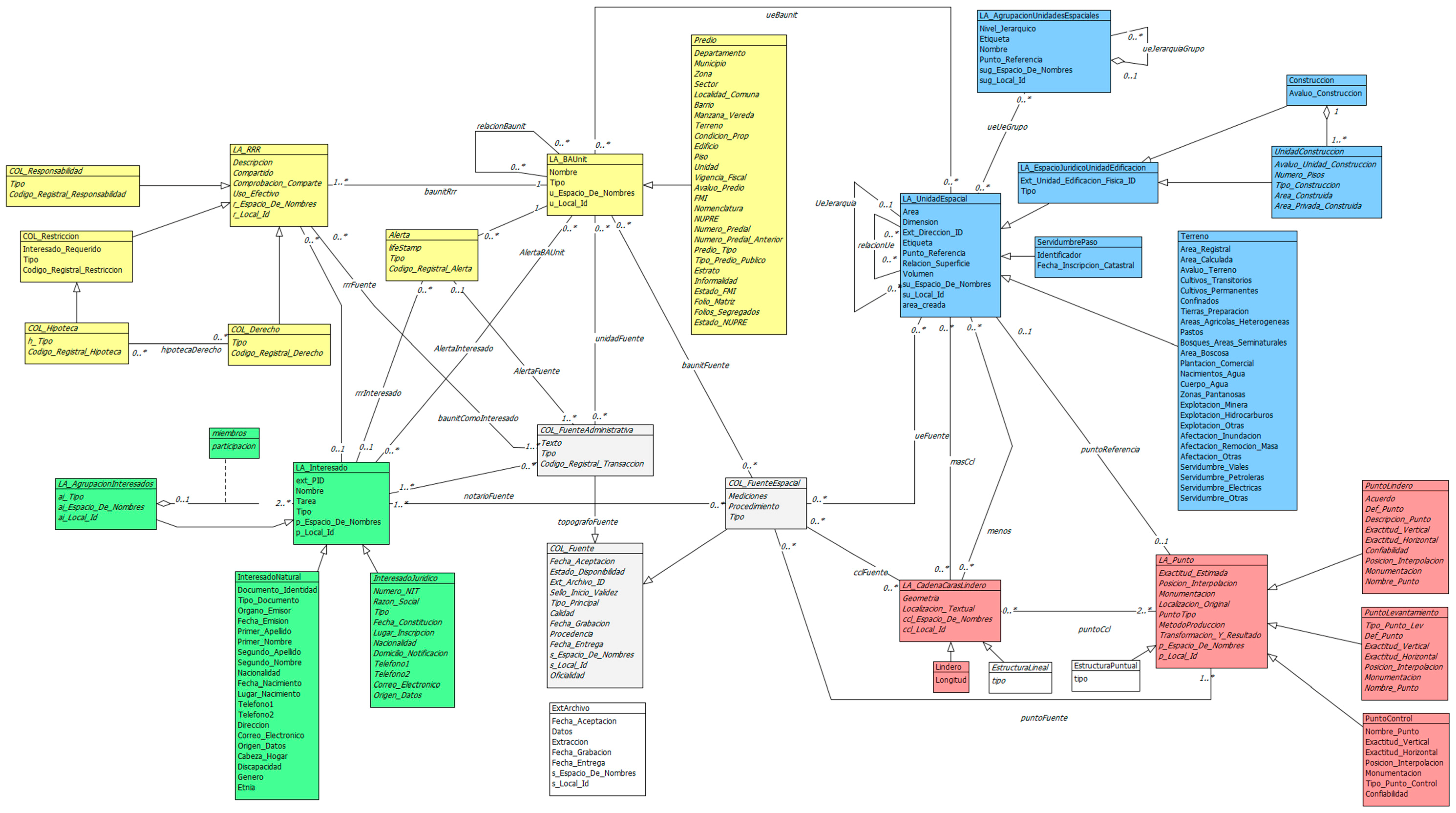
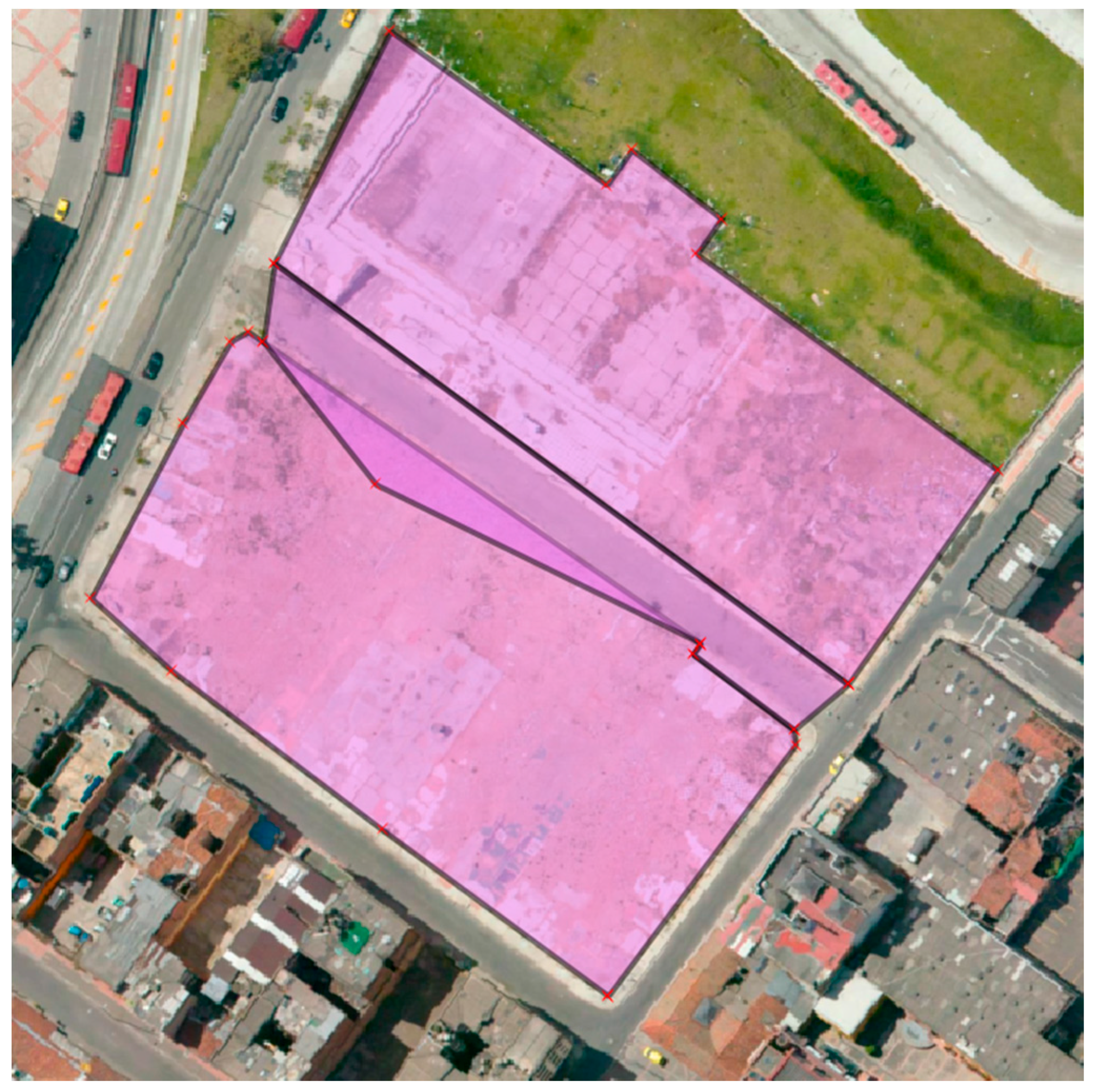
4.3. INTERLIS in Colombia
5. Implementation
5.1. Code Lists and Enumerations
5.1.1. Semantics in Code Lists
STRUCTURE GR_PartyRoleType EXTENDS LADM.Party.LA_PartyRoleType =
     cID: MANDATORY Oid;
     parent_cID: Oid REFERENCE TO LADM.Party.LA_PartyRoleType.cID;
     begin_Date_Time: XMLDate;
     end_Date_Time: XMLDate;
     MANDATORY CONSTRAINT
     end_Date_Time>=begin_Date_Time
     description: CharacterString;
     !! Possible code list values:
     (lawyer,bank,notary,citizen,institution,tax_office,church,surveyor, insurance_organization,metropolis,parish,court,courtof_appeal,
     high_court,state_council,legislative_authority,local_authority,
     exproperiation_committee,ministry, urban_planning_authority,other);
END GR_PartyRoleType;
5.1.2. Enumeration Types
LA_StructureType = (point, line, polygon, other);
  COL_StructureType EXTENDS LA_StructureType = (
                        other (text, topological, drawing,
                        unstructured));
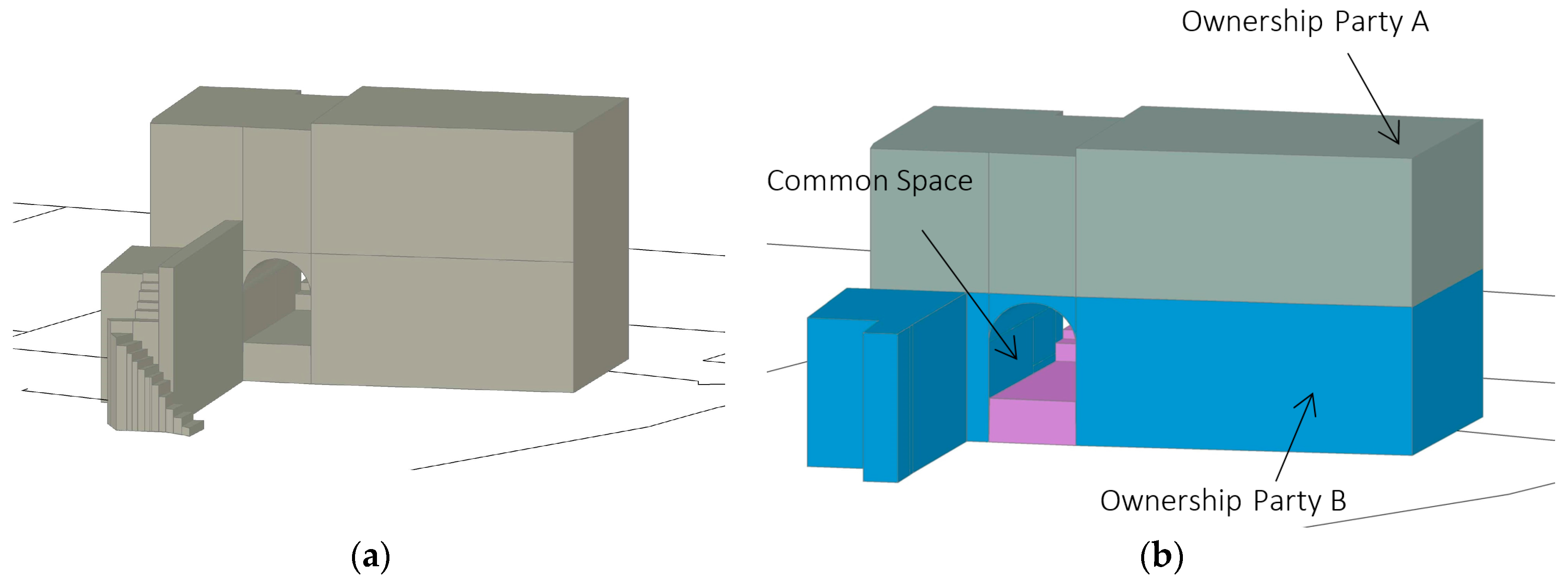
5.2. Formal Specification of Constraints
5.2.1. “Hard” and “Soft” Constraints
CLASS LA_BAUnit EXTENDS VersionedObject =
     name: CharacterString;
     type: MANDATORY (basic_propery_unit, right_unit, other);
     uID: MANDATORY Oid;
     constraints
     {sum(RRR.share)=1 per type if RRR.shareCheck
     no overlap RRR.timeSpec per summed type}
     invariant
     {share must be specified, unless this is meaningless for
     the specific type (indicated by shareCheck=false; in
     this case constraint “sum (LA_RRR.share) = 1 per type can
     not be applied)}
END LA_BAUnit;
STRUCTURE ExtArchive EXTENDS LADM_Base.External.ExtArchive =
   data: CharacterString;
   extraction: XMLDate;
   recordation: DateTime;
   sID: MANDATORY Oid;
   acceptance: XMLDate;
   submission: MANDATORY XMLDate;
   MANDATORY CONSTRAINT
   submission>=acceptance;
END ExtArchive;
......
CLASS GR_MarineParcel EXTENDS GR_Level =
   activity: GR_MarineActivityType;
   layerType: GR_MarineLayerType;
   resourceType: GR_MarineResourceType;
   zone: GR_MarineLayerType;
   MANDATORY CONSTRAINT
   GR_SpatialUnit.surfaceRelation = “below” OR
   GR_SpatialUnit.surfaceRelation = “mixed”;”
END  GR_MarineParcel;
......
FUNCTION no_overlaps(
        Objects: OBJECTS OF ANYCLASS;
        SurfaceAttr: ATTRIBUTE OF @ Objects RESTRICTION (SURFACE)
        ): BOOLEAN;
......
CLASS CO_Terrain EXTENDS LA_SpatialUnit =
        ......
        geometry: MANDATORY GM_Surface2D;
        SET CONSTRAINT no_overlaps(ALL,>> geometry);
END LA_BAUnit;
      Info: ilifile <C:\tmp\uploads\ilivalidator_8040\ISO19107_V1.ili>
      Info: ilifile <C:\tmp\uploads\ilivalidator_8040\Catastro_COL_ES.ili>
      Info: validate data...
      Info: first validation pass...
      Info: second validation pass...
      ...
      Info: evaluate: no_overlaps Over: LADM_COL.CO_Terrain tid: 17
Error: line 20: LADM_COL.CO_Terrain: tid 17: Set Constraint LADM_COL.CO_Terrain.no_overlaps is not true.
Info: evaluate: no_overlaps Over: LADM_COL.CO_Terrain tid: 18
Error: line 22: LADM_COL.CO_Terrain: tid 18: Set Constraint LADM_COL.CO_Terrain.no_overlaps is not true.
...
Info: ...validation failed
5.2.2. Cross-Model Constraints
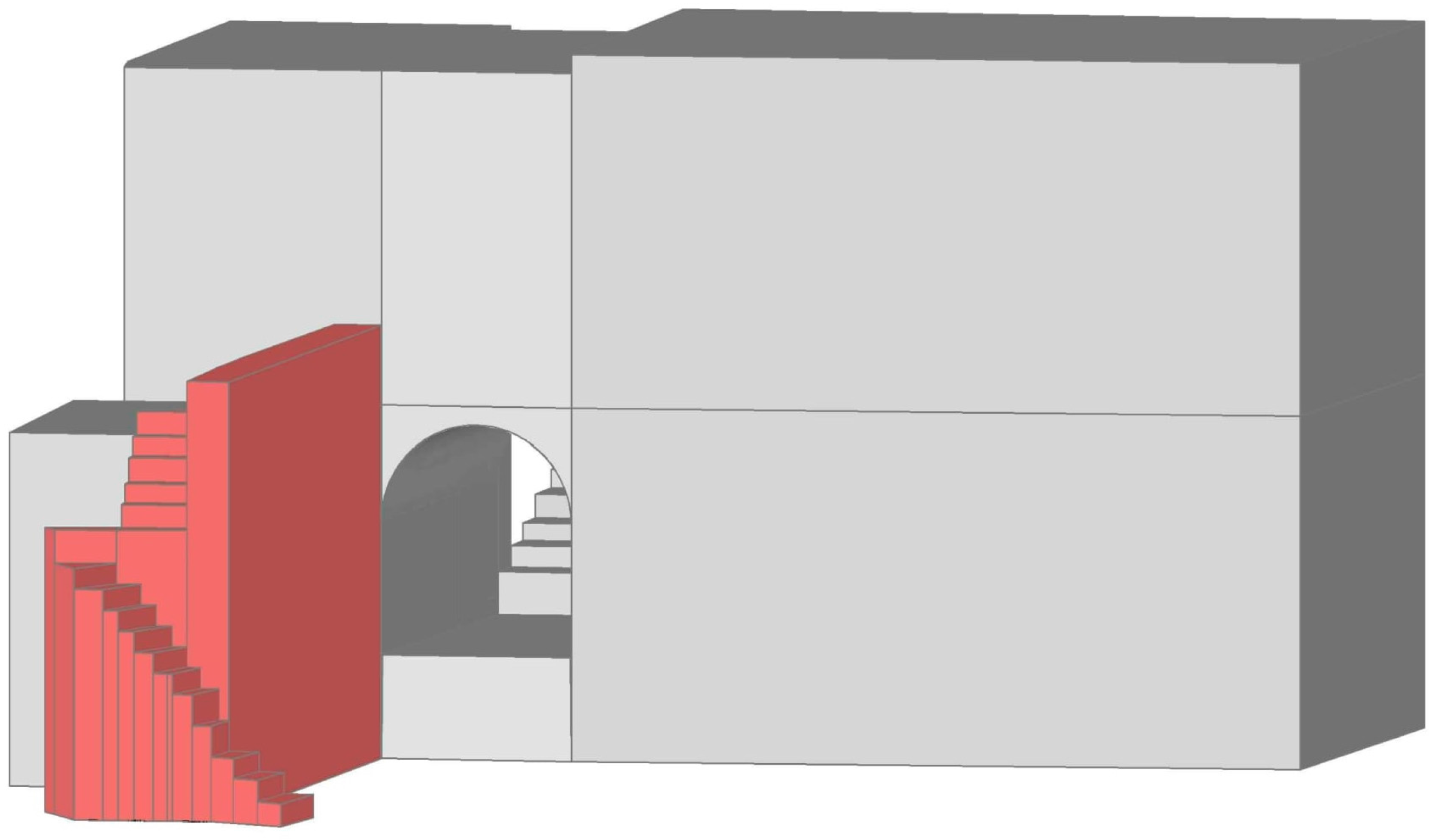
5.3. 3D Data Type in INTERLIS
GM_Point3D = COORD
     480000.000 .. 850000.000 [m],
     70000.000 .. 310000.000 [m],
     -1000.000 .. 9000.000 [m],
     ROTATION 2 -> 1;
GM_Curve3D = POLYLINE WITH (STRAIGHTS, ARCS) VERTEX GM_Point3D WITHOUT OVERLAPS > 0.001;
GM_Surface3D = SURFACE WITH (STRAIGHTS, ARCS) VERTEX GM_Point3D WITHOUT OVERLAPS > 0.001;
STRUCTURE GM_Curve3DListValue =
     value: MANDATORY GM_Curve3D;
END GM_Curve3DListValue;
STRUCTURE GM_Surface3DListValue =
     value: MANDATORY GM_Curve3D;
END GM_Surface3DListValue;
STRUCTURE GM_MultiCurve3D =
     geometry: LIST {1..*} OF GM_Curve3DListValue;
END GM_MultiCurve3D;
STRUCTURE GM_MultiSurface3D =
     geometry: LIST {1..*} OF GM_Surface3DListValue;
END GM_MultiSurface3D;
STRUCTURE GM_Object =
END GM_Object;
STRUCTURE GM_Solid EXTENDS GM_Object =
     geometry: LIST {1..*} OF GM_Surface3DListValue;
END GM_Solid;
FUNCTION validateSolidGeometry(solid:ISO19107.GM_Solid):BOOLEAN;
6. Conclusions
7. Discussion and Future Work
Acknowledgments
Author Contributions
Conflicts of Interest
References
- Object Management Group. Model Driven Architecture (MDA) MDA Guide Rev. 2.0. 2014. Available online: http://www.omg.org/cgi-bin/doc?ormsc/14-06-01.pdf (accessed on 26 September 2017).
- Kalogianni, E.; Dimopoulou, E.; Quak, W.; van Oosterom, P.J.M. Formalizing Implementable Constraints in the INTERLIS Language for Modelling Legal 3D RRR Spaces and 3D Physical Objects. In Proceedings of the 5th International FIG 3D Cadastre Workshop, Athens, Greece, 18–20 October 2016; pp. 137–157. [Google Scholar]
- Germann, M.; Kaufmann, J.; Steudler, D.; Lemmen, C.; van Oosterom, P.; de Zeeuw, K. The LADM based on INTERLIS. In Proceedings of the FIG Working Week 2015 from the Wisdom of the Ages to the Challenges of the Modern World, Sofia, Bulgaria, 17–21 May 2015. [Google Scholar]
- Germann, M.; Kaufmann, J.; Steudler, D.; Lemmen, C.H.J.; van Oosterom, P.; De Zeeuw, K. The LADM based on INTERLIS. In Proceedings of the World Cadastre Summit, Istanbul, Turkey, 20–24 April 2015. [Google Scholar]
- Jenni, L.; Guarín, L.A.; Ziegler, S.; Pérez, B.V.M. Development and Employment of a LADM Implementing Toolkit in Colombia. In Proceedings of the 2017 World Bank Conference on Land and Poverty: Responsible Land Governance–Towards an Evidence-Based Approach, The World Bank, Washington, DC, USA, 20–24 March 2017. [Google Scholar]
- Jenni, L.; Germann, M.; Eisenhut, C.; Guarin, L.A.; Bajo, V.M. LADM Implementation in Colombia–Process, Methodology and Tools developed and applied. In Proceedings of the FIG Working Week, Helsinki, Finland, 29 May–2 June 2017. [Google Scholar]
- Kalogianni, E. Design of a 3D Multipurpose Land Administrative System for Greece in the Context of Land Administration Domain Model (LADM). Master’s Thesis, National Technical University of Athens, Athens, Greece, 2015. [Google Scholar]
- Kalogianni, E.; Dimopoulou, E.; van Oosterom, P.J.M. A 3D LADM prototype implementation in INTERLIS. In Proceedings of the 10th 3D GeoInfo Conference, Kuala Lumpur, Malaysia, 28–30 October 2015; Abdul-Rahman, A., Ed.; Springer Nature: Berlin, Germany, 2017; pp. 385–408. [Google Scholar]
- Kalogianni, E. Linking the Legal with the Physical Reality of 3D Objects in the Context of Land Administration Domain Model (LADM). Master’s Thesis, Delft University of Technology, Delft, The Netherlands, 2016. [Google Scholar]
- International Organization for Standardization. ISO 19152, Geographic Information–Land Administration Domain Model (LADM), 1st ed.; ISO: Geneva, Switzerland, 2012; Available online: https://www.iso.org/standard/51206.html (accessed on 1 August 2017).
- De Vries, T.; Zlatanova, S. 3D Intelligent Cities. GEO Inf. 2011, 14, 6–8. [Google Scholar]
- Berry, K.J.; Mehta, S. An Analytical Framework for GIS Modeling. 2009. Available online: http://www.innovativegis.com/basis/papers/other/gismodelingframework/GISmodelingFramework.pdf (accessed on 19 April 2017).
- Aien, A.; Kalantari, M.; Rajabifard, A.; Williamson, I.; Bennett, R. Utilizing data modeling to understand the structure of 3D Cadastres. J. Spat. Sci. 2013, 58, 215–234. [Google Scholar] [CrossRef]
- Gózdz, K.; Pachelski, W.; van Oosterom, P.J.M.; Coors, V. The possibilities of using CityGML for 3D representation of buildings in the Cadastre. In Proceedings of the 4th International FIG 3D Cadastre Workshop, Dubai, UAE, 9–11 November 2014; pp. 339–361. [Google Scholar]
- Ying, S.; Guo, R.; Li, L.; He, B. Application of 3D GIS to 3D Cadastre in Urban Environment. In Proceedings of the 3rd International FIG 3D Cadastre Workshop: Developments and Practices, Shenzhen, China, 25–26 October 2012; pp. 25–26. [Google Scholar]
- Van Oosterom, P.J.M.; Stoter, J. 5D Data Modelling: Full Integration of 2D/3D Space, Time and Scale Dimensions. Geogr. Inf. Sci. 2010, 6292, 310–324. [Google Scholar]
- ePlan. In ePlan Model; Version 1.0; Intergovernmental Committee on Surveying and Mapping: Sydney, Australia, 2010; p. 61.
- Aien, A.; Rajabifard, A.; Kalantari, M.; Shojaei, D. Integrating legal and physical dimensions of urban environments. ISPRS Int. J. Geo-Inf. 2015, 4, 1442–1479. [Google Scholar] [CrossRef]
- IHO S-121. Product Specification for Maritime Limits and Boundaries. Available online: https://www.google.com/url?sa=t&rct=j&q=&esrc=s&source=web&cd=1&ved=0ahUKEwjhwZniv9DUAhUlCcAKHbrGBvEQFggiMAA&url=https%3A%2F%2Fwww.iho.int%2Fmtg_docs%2Fcom_wg%2FS-100WG%2FS-121PT%2FS121%2520Draft%2520Product%2520Specification%2520Revised%252001%2520Dec%252016%2520v2.3.8.docx&usg=AFQjCNFv_PaTC96xHdMRr9tigRZ6s9ERLg&cad=rja (accessed on 1 August 2017).
- BuildingSMART. IFC Product Extension. 2013. Available online: http://www.buildingsmarttech.org/ifc/IFC4/final/html/schema/ifcproductextension/content.htm (accessed on 18 April 2017).
- Industry Foundation Classes (IFC) for Data Sharing in the Construction and Facility Management Industries; ISO16739; International Organization for Standardization (ISO): Geneva, Switzerland, 2013.
- Groger, G.; Kolbe, T.H.; Nagel, C.; Hafele, K.H. OGC City Geography Markup Language (CityGML) Encoding Standard; Open Geospatial Consortium: Wayland, MA, USA, 2012. [Google Scholar]
- Scarponcini, P. InfraGML Proposal (13–121), OGC Land and Infrastructure DWG/SWG; Open Geospatial Consortium: Wayland, MA, USA, 2013. [Google Scholar]
- Scarponcini, P.; Gruler, H.C.; Stubkjaer, E.; Axelsson, P.; Wikstrom, L. OGC, Land and Infrastructure Conceptual Model Standard (LandInfra); Open Geospatial Consortium: Wayland, MA, USA, 2016. [Google Scholar]
- LandXML. LandXML 2.0 (Working Draft) Schema Announced. 2014. Available online: http://landxml.org/ (accessed on 7 October 2016).
- Zlatanova, S.; van Oosterom, P.J.M.; Lee, J.; Lic, K.J.; Lemmen, C.H.J. LADM and IndoorGML for support of indoor space identification. In Proceedings of the 11th 3D GeoInfo Conference, Athens, Greece, 20–21 October 2016. [Google Scholar]
- Atazadeh, B.; Kalantari, M.; Rajabifard, A. Comparing three types of BIM-Based Models for managing 3D ownership interests in multi-level buildings. In Proceedings of the 5th International FIG 3D Cadastre Workshop, Athens, Greece, 18–20 October 2016; pp. 183–198. [Google Scholar]
- Stadler, A.; Kolbe, T.H. Spatio-semantic Coherence in the Integration of 3D City Models. In Proceedings of the 5th International Symposium on Spatial Data Quality (ISSDQ), Enschede, The Netherlands, 13–15 June 2007. [Google Scholar]
- Dsilva, M.G. A Feasibility Study on CityGML for Cadastral Purposes. Master’s Thesis, Eindhoven University of Technology, Eindhoven, The Netherlands, 2009. [Google Scholar]
- Çağdaş, V. An application domain extension to CityGML for immovable property taxation: A Turkish case study. Int. J. Appl. Earth Obs. Geoinf. 2013, 21, 545–555. [Google Scholar] [CrossRef]
- Rönsdorff, C.; Wilson, D.; Stoter, J.E. Integration of Land Administration Domain Model with CityGML for 3D Cadastre. In Proceedings of the 4th International FIG 3D Cadastre Workshop, Dubai, UAE, 9–11 November 2014; pp. 313–322. [Google Scholar]
- Li, L.; Wu, J.; Zhu, H.; Duan, X.; Luo, F. 3D Modelling of the ownership structure of condominium units. Comput. Environ. Urban Syst. 2016, 59, 50–63. [Google Scholar] [CrossRef]
- Isikdag, U.; Horhammer, M.; Zlatanova, S.; Kathmann, R.; van Oosterom, P.J.M. Semantically rich 3D building and cadastral models for valuation. In Proceedings of the 4th International FIG 3D Cadastre Workshop, Dubai, UAE, 9–11 November 2014; pp. 35–53. [Google Scholar]
- El-Mekawy, M.; Östman, A. Feasibility of Building Information Models for 3D Cadastre in Unified City Models. Int. J. E-Plan. Res. IJEPR 2012, 1, 35–58. [Google Scholar] [CrossRef]
- Oldfield, J.; van Oosterom, P.J.M.; Quak, W.; van der Veen, J.; Beetz, J. Can Data from BIMs be Used as Input for a 3D Cadastre? Formalizing Implementable Constraints in the INTERLIS Language for Modelling Legal 3D RRR Spaces and 3D Physical Objects. In Proceedings of the 5th International FIG 3D Cadastre Workshop, Athens, Greece, 18–20 October 2016; pp. 199–214. [Google Scholar]
- Kim, S.; Kim, J.; Jung, J.; Heo, J. Development of a 3D Underground Cadastral System with Indoor Mapping for As-Built BIM: The Case Study of Gangnam Subway Station in Korea. Sensors 2015, 15, 30870–30893. [Google Scholar] [CrossRef] [PubMed]
- Zlatanova, S.; Lic, K.J.; Lemmen, C.H.J.; van Oosterom, P.J.M. Indoor Abstract Spaces: Linking IndoorGML and LADM. In Proceedings of the 5th International FIG 3D Cadastre Workshop, Athens, Greece, 18–20 October 2016; pp. 317–328. [Google Scholar]
- Soon, K.H. Representing Roles in Formalizing Domain Ontology for Land Administration. In Proceedings of the 5th Land Administration Domain Model Workshop, Kuala Lumpur, Malaysia, 24–25 September 2013; pp. 203–222. [Google Scholar]
- Soon, K.H.; Thompson, R.; Khoo, V. Semantics-based Fusion for CityGML and 3D LandXML. In Proceedings of the 4th International FIG 3D Cadastre Workshop, Dubai, UAE, 9–11 November 2014; pp. 323–338. [Google Scholar]
- Hespanha, J.P.; van Bennekom-Minnema, J.; van Oosterom, P.J.M.; Lemmen, C.H.J. The Model Driven Architecture Approach Applied to the Land Administration Domain Model Version 1.1-with Focus on Constraints Specified in the Object Constraint Language. In Proceedings of the Integrating Generations, FIG Working Week, Stockholm, Sweden, 14–19 June 2008. [Google Scholar]
- Kaufmann, J.; Steudler, D. Cadastre 2014–A vision for a future cadastral system. In Proceedings of the FIG XXI International Congress, Commission 8: Spatial Planning and Development, Brighton, UK, 19–25 July 1998. [Google Scholar]
- Hespanha, J.P. Development Methodology for an Integrated Legal Cadastre. Ph.D. Thesis, Delft University of Technology, Deft, The Netherlands, 2012. [Google Scholar]
- Hespanha, J.P.; Paixao, S.; Ghawana, T.; Zevenbergen, J.; Carneiro, A. Application of Land Administration Domain Model to Recognition of Indigenous Community Rights in the Philippines: Laws Examined with Spatial Dimensions (7579). In Proceedings of the FIG Working Week 2015, From the Wisdom of the Ages to the Challenges of the Modern World, Sofia, Bulgaria, 17–21 May 2015. [Google Scholar]
- Van Bennekom-Minnema, J. The Land Administration Domain Model “Survey Package” and Model Driven Architecture, Joint Programme in Geographical Information Management and Applications. Master’s Thesis, Utrecht University, Utrecht, The Netherlands, University of Twente/ITC Enschede, Enschede, The Netherlands, TU Delft, Deft, The Netherlands, Wageningen University, Wageningen, The Netherlands, 2008. [Google Scholar]
- Social Domain Tenure Model (SDTM). Available online: http://stdm.gltn.net/ (accessed on 1 July 2017).
- Van Bennekom-Minnema, J. Example Implementation LADM: IT System Specification, Draft 25 March 2011.
- Zein, T.; Hartfiel, P.; Berisso, Z.A. Addis Ababa: The Road Map to Progress through Securing Property Rights with Real Property Registration System. In Proceedings of the World Bank Conference on Land and Poverty, Washington, DC, USA, 23–26 April 2012. [Google Scholar]
- Gruber, T.R. A Translation Approach to Portable Ontology Specifications. In Knowledge Acquisition; Academic Press Ltd.: London, UK, 1993; Volume 5, pp. 199–220. [Google Scholar]
- Mäs, S.; Wang, F.; Reinhardt, W. Using ontologies for integrity constraint definition. In Proceedings of the 4th International Symposium on Spatial Data Quality (ISSDQ), Beijing, China, 25–26 August 2005. [Google Scholar]
- Object Management Group. Documents Associated With Object Constraint Language (OCL™), Version 2.4. 2014. Available online: http://www.omg.org/spec/OCL/2.4/ (accessed on 26 September 2017).
- Louwsma, J.; Zlatanova, S.; van Lammeren, R.; van Oosterom, P.J.M. Specifying and implementing constraints in GIS–with examples from a Geo-Virtual Reality System. GeoInformatica 2006, 10, 531–550. [Google Scholar] [CrossRef]
- Xu, D.; van Oosterom, P.J.M.; Zlatanova, S. A Methodology for modelling of 3D Spatial Constraints, Chapter. In Advances in 3D Geoinformation; Abdul-Rahman, A., Ed.; Springer: Basel, Switzerland, 2016; pp. 95–117. [Google Scholar]
- Chiang, R.H.L.; Barron, T.M.; Storey, V.C. Reverse engineering of relational databases: Extraction of an EER model from a relational database. Data Knowl. Eng. 1994, 12, 107–142. [Google Scholar] [CrossRef]
- Duboisset, M.; Pinet, F.; Kang, M.A.; Schneider, M. Precise modelling and verification of topological integrity constraints in spatial databases: From an expressive power study to code generation principles. In Conceptual Modelling–ER; Delcambre, L., Kop, C., Mayr, H.C., Mylopoulos, J., Pastor, O., Eds.; Springer: Berlin, Germany, 2005; pp. 465–482. [Google Scholar]
- Van Oosterom, P.J.M. Constraints in spatial data models, in a dynamic context. In Dynamic and Mobile GIS: Investigating Changes in Space and Time; Drummond, J., Billen, R., Joao, E., Forrest, D., Eds.; CRC Press: Boca Raton, FL, USA, 2006; pp. 104–137. [Google Scholar]
- Lemmen, C.H.J.; van Loenen, B.; van Oosterom, P.J.M.; Paasch, J.; Paulsson, J.; Ploeger, H.D.; Zevenbergen, J. Legal Refinement of the LADM Standard: More classes or extended code lists with better defined types of Rights, Restrictions and Responsibilities? In Proceedings of the PLPR 2014 8th Annual Conference on Planning, Law and Property Rights, Haifa, Israel, 12–14 February 2014. [Google Scholar]
- European Land Information Service (EULIS). 2017. Available online: http://eulis.eu/about-us/ (accessed on 25 March 2017).
- Lutz, M.; Portele, C.; Cox, S.M.J.; Muraay, K. Code Lists for Interoperability—Principles and Best Practices in INSPIRE. 2012. Available online: https://presentations.copernicus.org/EGU2012-10415_presentation.pdf (accessed on 23 October 2017).
- International Organization for Standardization. ISO 19135:2005 Geographic Information–Procedures for Item Registration; ISO: Geneva, Switzerland, 2005. [Google Scholar]
- W3C OWL Working Group. OWL 2 Web Ontology Language: Document Overview (Second Edition). Available online: http://www.w3.org/TR/owl2-overview/ (accessed on 10 July 2013).
- Janecka, K.; Karki, S. 3D Data Management–Overview Report. In Proceedings of the 5th International FIG 3D Cadastre Workshop, Athens, Greece, 18–20 October 2016; pp. 215–260. [Google Scholar]
- W3C. SKOS Simple Knowledge Organization System Namespace. 2004. Available online: https://www.w3.org/TR/owl-ref/ (accessed on 23 October 2017).
- Web Ontology Language (OWL). Available online: https://www.w3.org/OWL/ (accessed on 1 August 2017).
- Çağdaş, V.; Abdullah, K.; Işikdağ, Ü.; van Oosterom, P.J.M.; Lemmen, C.H.J.; Stubkjaer, E. A Knowledge Organization System for the Development of an ISO 19152:2012 LADM Valuation Module. In Proceedings of the FIG Working Week 2017, Surveying the World of Tomorrow-From Digitalisation to Augmented Reality, Helsinki, Finland, 29 May–2 June 2017. [Google Scholar]
- Çağdaş, V.; Stubkjær, E. Core immovable property vocabulary for European linked land administration. J. Surv. Rev. 2014, 47, 49–60. [Google Scholar] [CrossRef]
- Cadastre and Land Administration Thesaurus (CaLAThe). 2017. Available online: http://cadastralvocabulary.org (accessed on 2 October 2016).
- Paasch, M.J. Standardization of Real Property Rights and Public Regulations. The Legal Cadastral Domain Model. Ph.D. Thesis, Royal Institute of Technology (KTH), Stockholm, Sweden, 2012. [Google Scholar]
- Paassch, M.J.; van Oosterom, P.J.M.; Lemmen, C.H.J.; Paulsson, J. Further modelling of LADM’s rights, restrictions and responsibilities (RRRs). Land Use Policy 2015, 49, 680–689. [Google Scholar]
- KOGIS. INTERLIS 2.3 Reference Manual; Coordination, Geo-Information and Services (COGIS), a Division of the Swiss Federal Office of Topography: Wabern, Switzerland, 2006. [Google Scholar]
- Swiss Government. Federal Act on Geoinformation. Bern. 2007. Available online: http://www.admin.ch/opc/en/classified-compilation/20050726/index.html (accessed on 7 October 2016).
- Lemmen, C.H.J. A Domain Model for Land Administration. Ph.D. Thesis, Delft University of Technology, Deft, The Netherlands, 2012. [Google Scholar]
- Acuerdo Final. Acuerdo Final Para la Terminación del Conflicto y la Construcción de una Paz Estable y Duradera from Mesa de Conversaciones. Available online: https://www.mesadeconversaciones.com.co/sites/default/files/24_08_2016acuerdofinalfinalfinal-1472094587.pdf (accessed on 26 September 2017).
- Zulkifli, N.; Rahman, A.; Jamil, H.; Hua, T.C.; Choon, T.L.; Seng, L.K.; Lim, C.K.; van Oosterom, P.J.M. Towards Malaysian LADM Country Profile for 2D and 3D Cadastral Registration System. In Proceedings of the 10th 3D GeoInfo Conference, Kuala Lumpur, Malaysia, 28–30 October 2015. [Google Scholar]
- International Organization for Standardization. ISO 19107:2003 Preview Geographic Information–Spatial Schema; ISO: Geneva, Switzerland, 2003. [Google Scholar]
- Lemmen, C.H.J.; van Oosterom, P.J.M.; Kalantari, M.; Unger, E.M.; Teo, C.H.; de Zeeuw, K. Further Standardization in Land Administration. In Proceedings of the 2017 World Bank Conference on Land and Poverty: Responsible Land Governance–Towards an Evidence-Based Approach, The World Bank, Washington, DC, USA, 20–24 March 2017. [Google Scholar]
- Lemmen, C.H.J.; van Oosterom, P.J.M.; Bennett, R. The Land Administration Domain Model. Land Use Policy 2015, 49, 535–545. [Google Scholar] [CrossRef]
- The 6th Land Administration Domain Model (LADM) Workshop. Available online: http://wiki.tudelft.nl/bin/view/Research/ISO19152/LADM2017Workshop (accessed on 25 August 2017).
- Summary of the 6th Land Administration Domain Model (LADM) Workshop. Available online: http://wiki.tudelft.nl/pub/Research/ISO19152/WorkshopAgenda2017/8_9_LADM_prelim_decisions.pdf (accessed on 25 August 2017).
- International Organization for Standardization/TC46. ISO 3166–1, Codes for the Representation of Names of Countries and Their Subdivisions–Part 1: Country Codes; ISO: Geneva, Switzerland, 2006. [Google Scholar]
- Ledoux, H. On the Validation of Solids Represented with the International Standards for Geographic Information. Comput. Aided Civ. Infrastruct. Eng. 2013, 28, 693–706. [Google Scholar] [CrossRef]


| Legal | Physical | Integrated Model | Via | Purpose | Reference |
|---|---|---|---|---|---|
| LADM | CityGML | - | ADE | Chinese jurisdiction | [32] |
| 3D cadastre | [31] | ||||
| Polish cadastre | [14] | ||||
| Dutch jurisdiction | [29] | ||||
| Turkish jurisdiction | [30] * | ||||
| ePlan | CityGML & 3D LandXML | - | LADM OWL | Semantic harmonization | [38,39] |
| LADM | IndoorGML | - | - | assigning RRR information to indoor spaces | [26,37] |
| LADM & LandXML concepts | IFC & CityGML concepts | LandInfra | - | model information about land & infrastructure facilities | [23,24] |
| - | - | 3DCDM | Legal Property Object & Physical Object | Integrated approach managing legal & physical dimensions of 3D RRR spaces | [18] |
| - | IFC & BIM | Cadastral extension for UBM | - | 3D Cadastral system using IFC and BIM | [34] |
| - | IFC/CityGML | - | - | Valuation and taxation enhancement | [33] |
| - | BIM | Integrated BIM model | - | BIM for Urban Land Administration | [27] |
| - | IFC (IfcSpace, IfcZone) | - | “IfcRelSpaceBoundary” | Obtaining legal spaces from BIM models | [35] |
| - | BIM (as-built) | - | - | managing RRR information associated with 3D properties located underground in the context of Korean jurisdiction | [36] |
| LADM | INTERLIS | - | - | [2,3,5] |
© 2017 by the authors. Licensee MDPI, Basel, Switzerland. This article is an open access article distributed under the terms and conditions of the Creative Commons Attribution (CC BY) license (http://creativecommons.org/licenses/by/4.0/).
Share and Cite
Kalogianni, E.; Dimopoulou, E.; Quak, W.; Germann, M.; Jenni, L.; Van Oosterom, P. INTERLIS Language for Modelling Legal 3D Spaces and Physical 3D Objects by Including Formalized Implementable Constraints and Meaningful Code Lists. ISPRS Int. J. Geo-Inf. 2017, 6, 319. https://doi.org/10.3390/ijgi6100319
Kalogianni E, Dimopoulou E, Quak W, Germann M, Jenni L, Van Oosterom P. INTERLIS Language for Modelling Legal 3D Spaces and Physical 3D Objects by Including Formalized Implementable Constraints and Meaningful Code Lists. ISPRS International Journal of Geo-Information. 2017; 6(10):319. https://doi.org/10.3390/ijgi6100319
Chicago/Turabian StyleKalogianni, Eftychia, Efi Dimopoulou, Wilko Quak, Michael Germann, Lorenz Jenni, and Peter Van Oosterom. 2017. "INTERLIS Language for Modelling Legal 3D Spaces and Physical 3D Objects by Including Formalized Implementable Constraints and Meaningful Code Lists" ISPRS International Journal of Geo-Information 6, no. 10: 319. https://doi.org/10.3390/ijgi6100319