Review

The Standardization and Harmonization of Land Cover Classification Systems towards Harmonized Datasets: A Review

1
School of Resource and Earth Sciences, China University of Mining and Technology, Xuzhou 221116, China
2
Key Laboratory of Coal Bed Gas Resources and Forming Process of Ministry of Education, China University of Mining and Technology, Xuzhou 221116, China
3
Department of Civil Engineering, Ryerson University, Toronto, ON M5B 2K3, Canada
4
Geomatics Center of China, Beijing 100830, China
*
Author to whom correspondence should be addressed.
ISPRS Int. J. Geo-Inf. 2017, 6(5), 154; https://doi.org/10.3390/ijgi6050154
Submission received: 31 March 2017 / Revised: 15 May 2017 / Accepted: 15 May 2017 / Published: 19 May 2017
(This article belongs to the Special Issue Analysis and Applications of Global Land Cover Data)

Abstract

:
A number of national, regional and global land cover classification systems have been developed to meet specific user requirements for land cover mapping exercises, independent of scale, nomenclature and quality. However, this variety of land-cover classification systems limits the compatibility and comparability of land cover data. Furthermore, the current lack of interoperability between different land cover datasets, often stemming from incompatible land cover classification systems, makes analysis of multi-source, heterogeneous land cover data for various applications a very difficult task. This paper provides a critical review of the harmonization of land cover classification systems, which facilitates the generation, use and analysis of land cover maps consistently. Harmonization of existing land cover classification systems is essential to improve their cross-comparison and validation for understanding landscape patterns and changes. The paper reviews major land cover classification standards according to different scales, summarizes studies on harmonizing land cover mapping, and discusses some research problems that need to be solved and some future research directions.

1. Introduction

Land cover is biophysically recognizable on the Earth’s surface in a certain moment. Land cover datasets play a significant role in a variety of geographical studies, such as natural resources management [1,2], global climate change detection [3,4,5], sustainable urban development [6,7], and earth system simulation [8,9].
Despite the significance of land cover acting as an important environmental variable, our knowledge of land cover and its dynamics is still poor [10]. Technical advances, such as the vast amount of remote sensing data that has become available from earth observation satellites, have helped improve our understanding of land cover [11]. This has led to an increasing number of land cover datasets that have been independently produced from different remote sensing data to serve different scientific purposes. Potential users of land cover data are still left wondering which dataset is most useful (in terms of thematic content and accuracy) for their purposes, or how to effectively combine the results of the different land cover datasets to improve their applications [12].
In this context, the comparison of heterogeneous datasets is essential for meaningful accuracy assessment and change detection to provide improved land cover products [13]. However, these heterogeneous land cover datasets were not designed to be comparable and compatible because they adopt discrepant classification systems and legends to convert different satellite image to land cover thematic map products. A initial comparative analysis of global land cover 2000 and MODIS land cover datasets has been undertaken which takes two additional considerations into account: (1) how to compare maps that have two different legend categories; and (2) how to capture classification uncertainty in order to create a map of spatial agreement/disagreement [14]. To capture the uncertainty associated with both the differences in the land and the difficulty in classification when comparing two land cover maps, expert knowledge and a fuzzy logic framework were used to map the fuzzy agreement [15]. The current lack of interoperability between different land cover datasets, often stemming from incompatible land cover classification systems and legends, makes the analysis of multi-source, heterogeneous land cover data for various applications a very difficult task.
The classifications which describe the systematic frameworks with the name of the classes and the criteria used to distinguish them and the relation between classes [16] depend on a specific user’s requirements, including biodiversity, planning, monitoring and statistics. The first classification, the United States Geological Survey (USGS) Land Cover/Land Use Classification System [17,18], developed as an a priori hierarchical subdivision of the classes, has been widely used to produce land cover maps from satellite images. Later, the US Earth Satellite Corporation (EarthSat) GeoCover Land Cover Legend [19] defined 13 classes based on the USGS 1976 classification system. The National Land Cover Characterization Project, aimed to develop a univocal classification method in the USA, defined the National Land Cover Data (NLCD) Classification System (NLCD 1992-CS and NLCD 2001-CS) [20,21]. The United Nations Environmental Programme/Food and Agriculture Organization of the United Nations (UNEP/FAO (1993), USGS and International Geosphere-Biosphere Programme-Data and Information System (IGBP-DIS) Land Cover Legend (1996) were derived from modification of the USGS 1976 classification method/system [22]. The Land Cover Classification System (LCCS) is the only system based on independent and universal valid land cover criteria developed by FAO/UNEP [23]. The Global Land Cover Network (GLCN), deriving from the innovative and dynamic methodologies, was developed in the LCCS [24]. Coordination of Information on the Environment (CORINE) Land Cover90 (CLC90) and its later updates are presented at European level by European Commission services as basic instruments for the definition of political programs related to the territory [25].
The status of land cover classification systems briefly shows that the available classifications and legends about land cover at different scales are heterogeneous, fragmented and difficult to coordinate. Despite the fact that there are many classification systems around the world, very few has been well accepted as international standards. The standardization and harmonization of land cover classification systems are therefore important first steps towards interoperated land cover datasets. Over the past decade, a large number of studies have been conducted, focusing on the standardization and harmonization of different land cover classification systems [26]. In 1993, the UNEP and FAO organized a meeting to catalyze coordinated actions towards harmonization of data collection and management, and to take a first step towards an internationally agreed reference base for land cover and land use [27]. The Africover Programme of the Environment and Natural Resources Service is another example effort, which intended to map land cover for entire Africa. The program adopted LCCS as a harmonized land cover reference system for operational use [28]. Although efforts in standardization and harmonization are mentioned in nearly all related mapping projects, as well as in many other circumstances, there is only limited compatibility and comparability between these different classifications and their thematic legends—they basically exist as independent datasets [29].
Standardization and harmonization of classifications enables us to combine existing heterogeneous land cover datasets to support global land cover data analysis. It may face several challenges due to the inconsistency in systematic terminology, semantic content and cartographic legends. Consistency is an essential requirement for land cover assessment and monitoring of its dynamic changes in environmental analysis and planning. This paper aims to briefly review the history of land cover classification systems according to national, regional and global scales, and introduces the main harmonization approaches of the land cover classification systems. It further considers how standardization and harmonization are achieved before looking at some of the problems encountered and suggesting future research priorities.

2. Existing Land Cover Classification Systems

Land cover generally refers to the observed biophysical surface of the Earth, including water, forests, agricultural land, wetland, build-up areas and so on. In order to properly describe these observable features, it is important to define land cover classes and legends. A land cover classification system is an abstract representation with the names, codes and definitions of the classes, the well-defined diagnostic criteria (classifiers) used to distinguish different types of land cover, and the relationship among land cover classes. The primary purpose of classification is to describe the structure and relationship of groups of similar objects [30]. Land cover classification thus requires the definition of land cover class boundaries, which should be clear, precise, possibly quantitative, and based upon a set of objective criteria.
Figure 1 shows the overview of the FAO/UNEP Land Cover Classification System which can be employed as a harmonized land cover reference system [30]. The system framework of LCCS is designed with two main phases. In initial Dichotomous Phase, eight major land cover types are defined, including Cultivated and Managed Terrestrial Areas, Natural and Semi-Natural Terrestrial Vegetation, Cultivated Aquatic or Regularly Flooded Areas, Natural and Semi-Natural Aquatic or Regularly Flooded Vegetation, Artificial Surfaces and Associated Areas, Bear Areas, Artificial Waterbodies, Snow and Ice, and Natural Waterbodies, Snow and Ice. This is followed by a subsequent so-called Modular-Hierarchical Phase, in which land cover classes are created by the combination of sets of pre-defined pure classifiers [31]. These classifiers are defined by two types of attributes: Environmental Attributes (e.g., climate, landform, altitude, soils, lithology and erosion) and Specific Technical Attributes (e.g., floristic aspect, crop type, and soil type), which can be used to reduce the likelihood of impractical combinations of classifiers.
Field surveys and analysis of remote sensing imagery are two primary methods for capturing information on land cover. The origin of the land cover classification systems goes back to the vegetation systematic classification concept [32], which was defined as a classification system for plants in the mid-18th century. Since 1971, more detailed frameworks of land cover classification systems have been developed, beginning with the analysis of remote sensing imagery era [18]. The following sections provide a review of the land cover classification systems for use with application to remotely sensed optical data, which can be generally divided into three different groups according to territorial information scales: national, regional and global.

2.1. National Scale

For many years, agencies at various governmental levels and institutions have been collecting land cover data, but most of them have worked independently and without coordination [18]. The land cover classification systems at a national scale always refer to smaller scales than those generally used for large-scale topographic mapping (the study of source materials, map design and production at 1:5000–1:10,000 scales).
The National Land Survey (NLS) database of China consists of two products completed by the first NLS (the 1984 land survey) and the second NLS (the 2007 land survey). The first NLS adopted a two-level standardized hierarchical classification system since 1995, which consists 8 level-I classes and 46 level-II classes [33,34]. The second NLS used a new, two-level multidiscipline land classification system, which was released in the form of a national standard to guarantee a consistent product [35]. The National Land Cover Characterization Project [36], led by the USGS with the aim of developing a univocal classification standard in USA, has developed the NLCD 1992-CS and NLCD 2001-CS [20,21], NLCD2006 [36] and NLCD2011 [37]. In Mexico, several land use/cover mapping efforts have been done, mainly by the National Institute of Statistics, Geography and Informatics (INEGI), the official Mexican mapping agency, and the Institute of Geography of the National University of Mexico (UNAM). The nationwide Mexico land-cover maps were also produced in the 1970s at 1:250,000 scale using a classification system similar to the USGS 1976 classification system [38]. The South African Standard Land Cover classification system was proposed for the realization of the National Land Cover Database project. The United States Federal Geographic Data Committee (FGDC) has accepted the National Vegetation Classification Standard (NVCS) as information and classification standard to be used by all federal agencies [39]. Canada mapped 2000-era forest cover using Landsat data and produced the most detailed nationwide forest cover map ever with the National Forest Inventory (NFI) Land Cover Classification Scheme [40]. Similar national mapping activities were carried out in other countries. Some land-cover classification systems at the national scale are listed in Table 1.

2.2. Regional Scale

Land cover classification at a regional scale, between 1:250,000 and 1:100,000, always used the second and third-generation sensors for remote sensing that encompasses Landsat TM, SPOT-HRV/XS, IRS-1C/LISS, Landsat ETM+, and MODIS, etc. CORINE, AFRICOVER and the Asian Association on Remote Sensing (AARS) projects have been realized at this scale (see Table 2). The European Union CORINE land-cover program represents a comprehensive approach to providing ongoing land-cover products for the most of the European Union [41]. CORINE Land Cover (CLC) provides snapshots of the land cover situation in Europe in 1990, 2000, 2006, and 2012 [25]. CLC90 and its later updates are presented at European level by the European Commission services as basic instruments for the definition of political programs related to the territory by the European Environment Agency (EEA). The AFRICOVER project, initiated by the FAO of the United Nation, provides accurate and reliable land cover information, based on uniform mapping specifications, for the whole continent of Africa [42]. The overall objective of the AFRICOVER-EA project was to improve the availability of reliable, timely and location-specific land cover information in 12 African countries (Egypt, Sudan, Ethiopia, Djibouti, Eritrea, Somalia, Kenya, Uganda, Tanzania, Rwanda, Burundi and the Democratic Republic of Congo) covering an area of over 9.5 million km2 [31]. The UN’s FAO has also initiated a similar project, ASIACOVER, which provides similar land-cover capabilities for the Southeast Asian countries. The Land Cover Working Group (LCWG) of the AARS also aims to develop Asia-Wide Land Use and Cover dataset with 30 arc-second grid [43]. The AARS land cover classification system was developed through discussion with members of the LCWG/AARS [44]. The North American Land Change Monitoring System (NALCMS) attempts to provide homogeneous land cover and land cover change products at an annual interval for the North American Continent [45]. It is a trilateral effort of institutions in Canada (Canadian Centre for Remote Sensing), the United States USGS, and Mexico (INEGI; National Commission for Forestry; National Commission for the Knowledge and Use of Biodiversity), and is united by the intergovernmental Commission for Environmental Cooperation.

2.3. Global Scale

The land cover classification system at a global scale refers to scales smaller than 1:250,000, which always uses the NOAA Advanced Very High Resolution Radiometer (AVHRR) satellites. Several global land cover classification systems have been developed in the past 30 years, are still being used today, and will stay in the future because they often serve specific needs. Investments have been made to exploit their data. Some well-known global land cover classification systems include the USGS land cover classification system, the EarthSat GeoCover Land Cover Legend, the UN/FAO Land Cover Legend, the Global Observation of Forest Cover and Global Observation of Land Cover Dynamics (GOFC/GOLD) Land and Forest Cover Classification System and LCCS, as well as many global definitions (see Table 3).
The first global legend, the USGS Land Cover/Land Use Classification System [17,18], consisting of nine land cover classes at 1:25,0000 scale at the first level, and 37 classes at 1:100,000 scale at the second level, has been widely used for producing land cover maps from satellite images. Following this, the US EarthSat used the USGS 1976 classification system as a base for the development of the US EarthSat GeoCover Land Cover Legend, which consists of 12 classes plus “not classified”, for the realization of the GlobalGeoCover LC database [19]. The UNEP/FAO Land Cover Legend (1993) consists of 9 land cover classes in the first level and 26 in the second level, which was developed by modification of the USGS 1976 classification system. FAO/UNEPLand Cover Classification System [23,28] has been explored and adopted by a number of international land assessment communities such as the IGBP-DIS Land Cover Legend with 17 classes [22], the GOFC/GOLD, and the UN GLCN and forest cover classification [24]. The University of Maryland (UMD) global Land Cover Classification from AVHRR satellites acquired between 1981 and 1994, developed by the UMD Department of Geography, were analyzed to distinguish 14 land cover classes in 1998 [46].

3. Efforts toward Standardization and Harmonization

The history of land cover classification systems outlined above indicates that although most of classifications were derived from LCCS, different institutions and programs still have developed some heterogeneous classifications and legends. Hence, the interpretation, analyses and integration of land cover datasets that use different classifications and legends have to face the problems of bringing land cover classification systems of nomenclatures, meaning, and mapping closer together to be more consistent. Not only is there a need for standardization of land cover classifications but there is also a need for harmonization of different existing land cover datasets in order to improve comparability, compatibility and conformity.

3.1. Terminology Standardization

To address this urgent need, standardization can help to overcome many previous limitations in land cover mapping on different scales. Terminology standardization of land cover classification systems is to support the land cover work of the other institutions and programs by providing them with the terminology to draft conceptually consistent land cover classification systems. The efforts for driving international terminology standards is essential for the detection and identification of the land cover dynamic changes. Standardization requires common definitions and standards to characterize land cover information worldwide and should eliminate all inconsistencies and differences between the datasets [29,47,48]. International consensus on the terminology issues involved in land cover classification systems can be divided into two types: de facto and de jure land cover classification systems standards.
De facto standards are “standards in actuality”, which are adopted widely by public acceptance or market forces. De facto land cover classification systems standards are worldwide reference frameworks that have achieved a dominant position, but that are not officially established. So far, most classifications have become de facto land-cover classification systems standards, and are still used today at national, regional and global levels.
In 1972, Dr. James Anderson at the USGS and several colleagues introduced the first draft of what has become the de facto standard for mapping land cover [49]. The classification systems used for NLCD 1992, NLCD 2001, NLCD2001, NLCD2006 and NLCD2011 were modified from the Anderson’s land use and land cover classification system with its de facto standard role in the USA. CLC, with ease of application and wide acceptance in previous studies, thus was created as a de facto standard for European land cover mapping and monitoring by the EEA [50]. The Land Cover Map and Geodatabase for the Africa project of the FAO/UNEP has developed an interactive land cover classification system, named LCCS, which has been adopted as a de facto international standard by a number of international land assessment communities [51]. The LCCS framework enhances the standardization process and minimizes the problem of dealing with a very large amount of pre-defined existing classes [52]. Because LCCS was developed as a comprehensive and standardized a priori classification system for land cover mapping exercises independent of scales or means [51] and was in the process of being established as an international standard classification system by the International Organization for Standardization (ISO), it was chosen as the most appropriate de facto standard.
De jure standards mean “standards according to law”, which are officially approved by formal standards bodies as opposed to de facto standards. The development of the NVCS, which has been accepted by FGDC, is regarded as a major step toward national vegetation classification standard to enhance the ability to understand, protect, and manage the natural resources of the United States [53,54,55,56].
FAO has submitted LCCS for approval to become an international standard through TC 211 Technical Committee of the ISO. ISO/TC 211 is responsible for developing international standards and technical specifications for digital geographic information and geomatics. The ISO 19144-X group of standards, entitled “classification systems”, establishes basic rules for structuring those schemas and defines a so-called land cover metalanguage that shall be used for writing such a scheme. It can be divided into two separate parts, which were assigned ISO numbers 19144-1 and 19144-2 under the general title of geographic Information-Classification systems.
“ISO 19144-1:2009-Geographic Information-Classification Systems-Part 1: Classification system structure” is a generic standard to define a set of rules for creating a classification system. The classification system subdivides an area into small units, each of which carries an identification code. “ISO 19144-2:2012-Geographic Information-Classification Systems-Part 2: Land Cover Meta Language (LCML)” is a UML metamodel that allows any land cover classes to be expressed based on a rigorous logical framework. The aim of ISO 19144-2:2012 is to enable the ability to compare and integrate information from existing different classification systems in a common reference language without replacing them [57].
Terminology standardization is the process of achieving consensus agreements as to which land cover terms will be used in a land cover classification system standard. It provides international standardizing committees with the ability to draft terminologically consistent standards and fosters interoperability between different land cover classification systems used in different organizations, projects and environments. Furthermore, the land cover institutions and programs would harmonize the land cover datasets collaboratively.

3.2. Semantic Interpretation

The framework for environmental observation and management needs to coordinate and exchange knowledge between land cover and other applications. As with land cover classifications, the content of other concept “landscapes” remains diverse, ambiguous, and difficult to apply consistently. However, this intention often results in a mix of land cover, land use or non-land cover/use definitions and favors semantic inconsistencies and a general vagueness of the class meaning. For instance, the LCCS was used to harmonize the General Habitat Categories System, which has been proposed by the ecological research community for the classification of habitats across various scales [58].
One important aspect of achieving standardization and harmonization in land cover classification systems is the notion of semantic interpretation. Semantic interpretation is defined as the process of matching the meaning of land cover classes between different classification systems. It helps to achieve harmonization by analyzing similarities and differences between definitions of land cover classes. The semantic interpretation between any two classification systems has been proved challenging, largely because of differences in definitions and related difficulties in creating one-to-one mapping relationships [59].
Theoretically, an expert with sufficient domain knowledge would be able to tell how similar two definitions of vegetation categories are and thus immediately determine the reusability of a particular land cover dataset [60]. However, classification systems are usually applied without considering the semantic problems that will cause confusion and could be misleading [61]. This again implies imprecise class, thus making interpretation error-prone and increasing the time and resources required for semantic mapping.
In this case, the definitions of actual land cover characteristics often remain uncertain. Uncertainty can arise when classifications are created by different people using different methods [62]. There are few existing approaches for map comparisons, which take into account both the problem of legend reconciliation and classification uncertainty. For example, a kappa fuzzy evaluation measure, which represents an overall measure of similarity for comparing raster maps of categorical data on a cell-by-cell basis, was developed [63]. The issue of differences in legend definitions was tackled by using expert knowledge to gather information on how different land cover datasets (in this case, the Land Cover Map of Britain 1990 and 2000) can be compared when the land cover classes have also changed their meaning [64]. To deal with the uncertainty associated with both differences in the legend and the difficulty in classification when comparing two land cover maps, expert knowledge and a fuzzy logic framework were used to map the fuzzy agreement [15], which considers overlap between legend definitions. An uncertainty analysis of the four well known global land cover mapping projects (including IGBP DISCover, UMD Land Cover, Global Land Cover 2000, and GlobCover 2009) using an error budget approach has been compared, summarized and enlightening [65].
Semantics in linguistic is defined as the relationships between words and the things to which these words refer [66], which is similar to our legend definition [67]. One step towards achieving semantic interoperability of existing land cover database and categorization is to develop methods for measuring the degree of semantic similarity between categories in different land use/land cover classification systems. Nowadays, there are approaches to measure semantic similarities between land cover classifications using natural language processing or concept lattices, tools for integration of heterogeneous ontologies, and change detection analysis in various land cover datasets.
The mathematical theory of Concept Lattices was used for managing multidimensional geographic categories and their overlapping relationships for integrating different land cover/land use categorizations [68]. The semantic content of a category was weighted to emphasize critical features in the categories definition. A case study was presented to demonstrate how semantic similarity is measured between target categories in a specific study and categories already in use in existing land use/cover classification systems [60].
Semantic interpretation aims to derive a solution for making different existing land cover classification systems interconnected and interoperable. Semantic interpretation is the process of determining the meaning of a land cover class, which provides the mechanism for combining, matching and translating the meaning of the class definitions from various land cover classification systems. Semantic interpretation is therefore an important part of harmonization since it allows the users of land cover datasets to focus on the meaning of land cover classes, its definitions, and how it relates to other classifications within the land cover field.

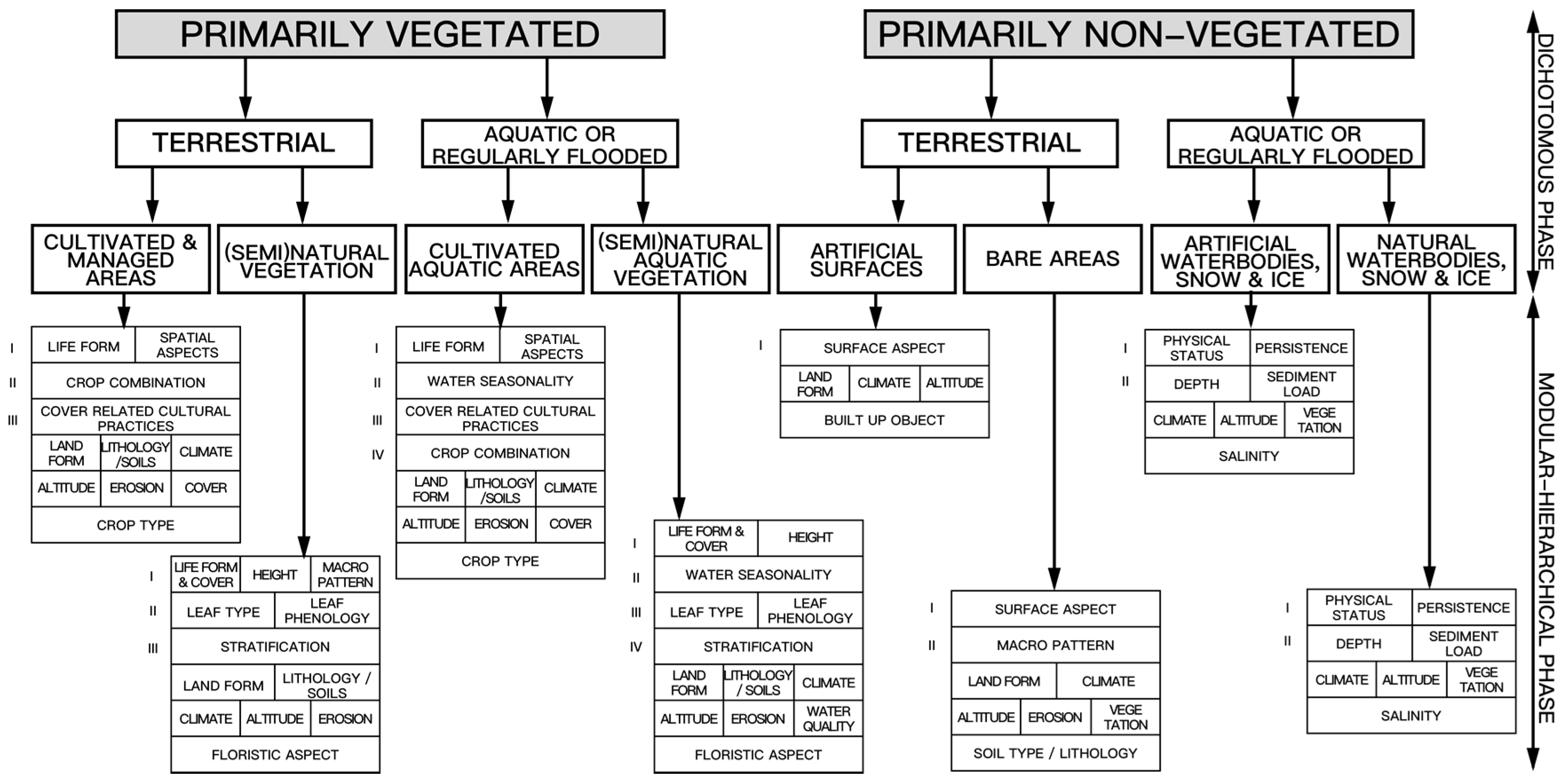
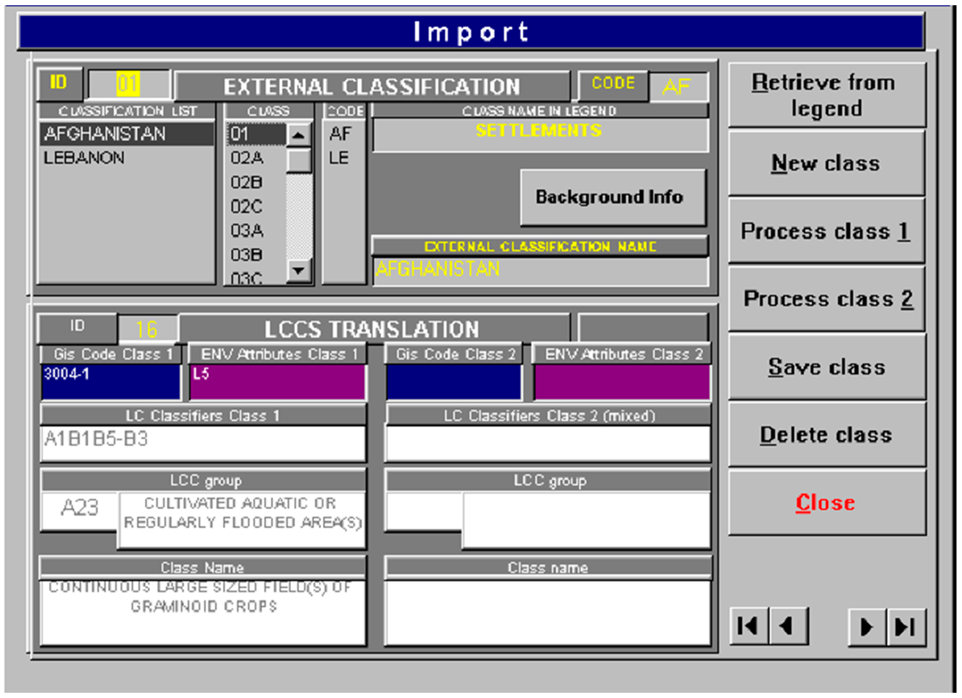
3.3. Legend Translation

The thematic legends are derived from different land cover classification systems, applied for specific mapping purposes at a specific place and defined scale, and thus they lack compatibility. It is the key issue for describing and interpreting the variety of specific landscape around the world. In this context, legend is essential for meaningful comparisons between different land cover classification systems. The translation of legends in a general schema is an essential step towards harmonization, which discovers the equivalence and subsumption relations between two or more land cover classification systems.
Translation provides the possibility to correlate global land cover classifications and legends by adopting the LCCS as a uniform reference base [69]. In order to facilitate the data collection coming from different land cover projects, the GLCN LCTC provides a translation form design according to LCCS methodology/translation concepts [47,48,70]. This process provides union of similarities between the original land cover classes and generic definitions of LCCS classifiers.
The potentiality of the classification systems was exploited during the legend translation phase [71]. The FAO-LCCS system has provided a successful collaborative Translator Module (see Figure 2) to balance both the need for standardization and stability of harmonization as a common language with sufficient flexibility for adapting to specific applications or scientific research [72]. Existing translated classifications and legends can be stored in this Translator Module for comparison and correlation of classifications and legends by using the LCCS as a reference base.
By using the FAO-LCCS Translator Module, a translation of the legends was performed for each single class between LCCS and ACS, CLC, IGBP and UMD. The legend translation form was designed for every land cover class, which was reviewed by the GOFC-GOLD land cover office and adjusted according to advice from GLCN-LCTC staff members. Legend properties and class descriptions of ACS, CLC, IGBP and UMD were found in their research paper, technical guide or web portal [18,41,46,73,74]. The assessment of the degree (%) of legend consistency and translation confidence is summarized in Figure 3 [75]. The range of these values indicates the difference faced across the legends during the translation process [75]. It is apparent that the legends with higher scores (IGBP, UMD) have only about one-half to one-third of the class number compared to ACS and CLC. The main reason is that ACS and CLC were not developed for global application translations, which were realized on the second and third level respectively. The more classes exist, the smaller the thematic class distances are, and the more likely are the inconsistencies and overlaps between classes.
Some of the products have used the LCCS in their development (Globcover, DRC map, Africover, GLCN and the MODIS-JRC dataset), while others have not [76]. The potential of Terra-ASTER data was systematically explored by LCCS classification in heterogeneous tree savannas of West Africa. This study is a step further towards the systematic combination of standardized LCCS legends with continuously available remote sensing data [72]. In another attempt to harmonize land cover classifications at the regional scale, FAO’s GLCN has launched the Regional HArmonization Programme (RHAP) initiative. The International Centre for Integrated Mountain Development (ICIMOD), in collaboration with FAO under GLCN-RHAP, has the purpose to reach consensus among region’s countries on the importance of harmonizing the approach for land cover inventory and land cover change assessment [77]. It initiated research to develop a common set of legends to be used in the Qomolangma National Nature Preserve (QNNP) in the Tibet Autonomous Region (TAR) of China, the Sagarmatha National Park and Buffer Zone (SNPBZ) in Nepal, and the Central Karakoram National Park in Pakistan, which addressed the immediate needs of the Hindu Kush-Karakoram-Himalaya (HKKH) region [78].
The legend is the mapping categories of the classification system, which is the key for reading and interpreting any land cover dataset [71]. Existing land cover legends should be translated to explore consistencies in current approaches for land cove harmonization. The translation of different legends provides a process of converting a mapping categorization of the original legend into another legend. Therefore, the purpose of translated legend is to identify and reassign every land cover cartographic types to foster harmonization of various land cover datasets.

4. Moving towards More Consistent Land Cover Classifications

There is only one “real” Earth’s surface, but many different land cover descriptions depending on the aims, methodology and domain of the observers. Over the past decade, a significant number of studies have been conducted, focusing on the harmonization of different existing land-cover classification systems. Although the terminology standardization, semantic interpretation, and legend translation approaches to harmonizing current or historical land cover classification systems seem relatively straightforward, many other issues are often encountered when harmonizing land cover classification systems. These problems range from discrepancies associated with structure, principle, threshold, and scale.

4.1. Terminological Consistency (Terminology Standardization)

Terminology consistency refers to the consistency of land cover classification that use the same or different technological terms (synonyms, acronyms, abbreviations, spelling variants, etc.). A pragmatic solution to the terminological inconsistency of land cover classification systems would be to build crosswalks for each country to guarantee terminological standardization on land covers in the future. By using the common standard land cover classification system at the required scale or level of detail, the content of the land cover information will be described and classified in an unambiguous and interoperable way. Furthermore, the classifiers can be interpreted and exchanged with other land cover products that adopt the same standards.
Despite the urgent need to establish and adopt a standard classification system, none of the current classifications has been internationally accepted. There may be many reasons for this situation. First, the land cover classes are highly discipline-related, which often need to be developed for a specific monitoring purpose. Second, the standardized classification systems contain broad classes that are too generic to be used efficiently by specialists from different disciplines. Third, the standardization of definitions often does not put major emphasis on existing systems of nomenclature. Fourth, the cost for standardization of land cover classification systems is so high that individual countries may not provide land cover data according to the international standard.
Ideally, harmonization should be guided by existing or evolving standards and thus has to use a common structure for reference [29]. Terminological standardization is not merely to introduce a new international standardized land cover classification system that will be applied in all national programs. The challenge is how to make a full use of the existing land cover datasets via online legend translation services to come up with the standard reference system. A further challenge may be dealing with the development of more inclusive legend translation services integrated with required automatic land cover data conversion from one classification system to another.

4.2. Semantic Consistency (Semantic Interpretation)

One difficulty in harmonizing land cover classification systems between different research parties is the variation of the semantic meaning of the land cover classes expressed using the related discipline. Semantic consistency is the consistency of the meaning of land cover classes which appears as a necessary condition for true interoperability of land cover classifications. For example, for vegetation, the method of how species are recorded can be specified, and for cultivated areas, the crop type can be specified. Terminology standardization approaches can assist in solving inconsistent terms, but does not approach the actual semantic problem, e.g., semantic overlap of existing heterogeneous land cover classification systems on finer or coarser scales.
Given the multitude of disciplines, it is obvious that too many nomenclatures reduce mutual understanding, agreement and relevance of different land cover categories. In addition, class definitions are unsystematic and inconsistent, and class boundaries appear barely understandable and arbitrary. Land cover and land use nomenclatures are also used simultaneously, which mixes to each other. Further, threshold-setting values are of key importance for land cover specific classifiers similarity assessment, i.e., density thresholds for urban areas indicating the composition of impervious surfaces.
Semantic interpretation is the process whereby similarities between existing definitions of land cover categories are emphasized and semantic inconsistencies are reduced. As described in Section 3.2, many approaches have been proposed to measure semantic similarities between land cover categories using sematic formalization, conceptual integration and natural language processing. Those approaches gave the opportunity to enhance the semantic interoperability of land cover classification systems. Despite successful examples for semantic interpretation, they only help resolve some semantics inconsistencies between land cover classes with expert knowledge.
Also, other issues still remain. It is difficult to capture semantic relationships from a posteriori land cover classification, which was deduced from characteristics of the survey field. At the moment, semantic interpretation can constitute a basis for harmonization through semantic relationships between nomenclatures, and thus induce future harmonization of land cover data sets, provided that the datasets also are comparable in terms of scale and detail.

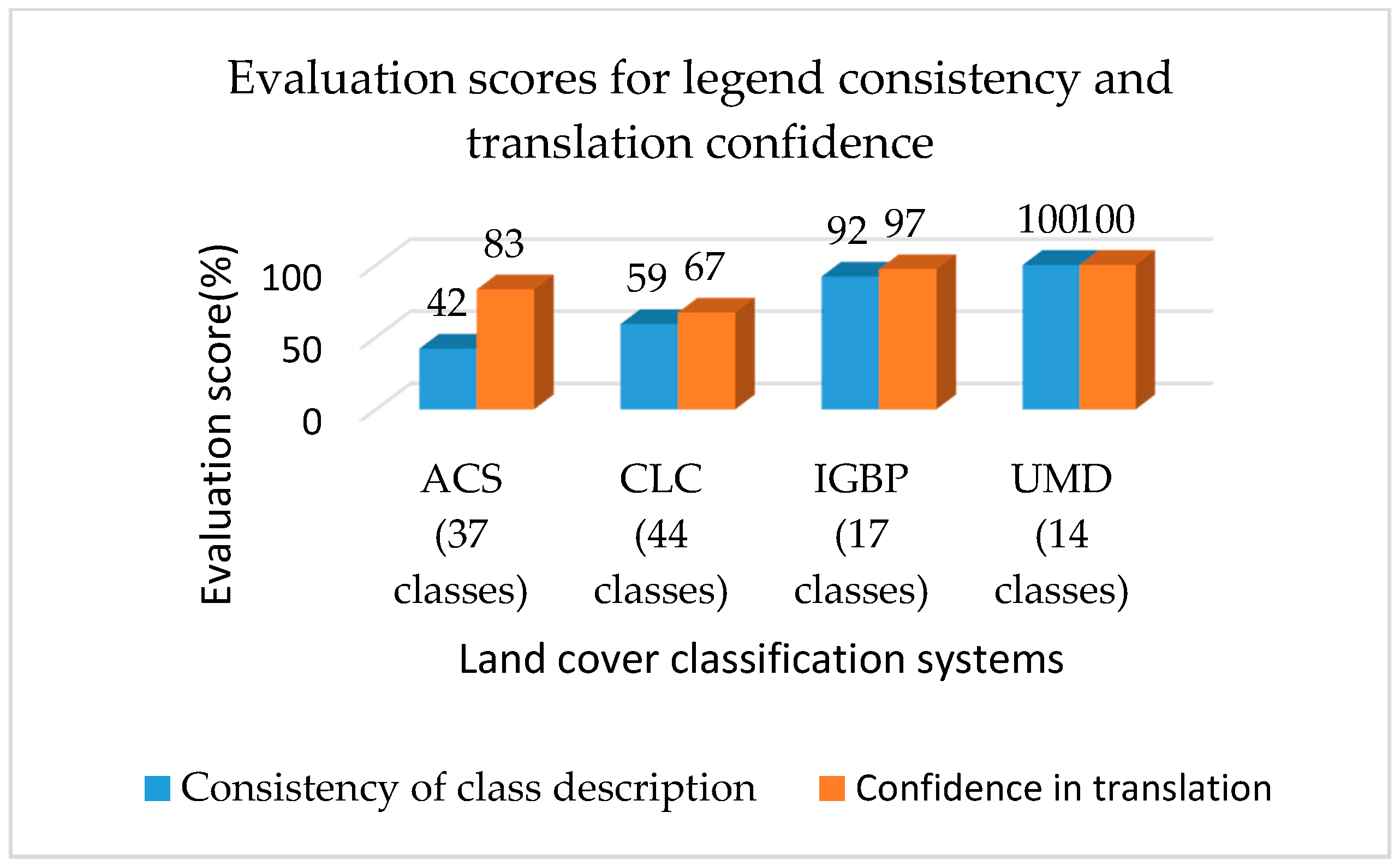
4.3. Cartographic Consistency (Legend Interpretation)

To promote greater understanding of various land cover maps, cartographic consistency can be used to measure the visual display of land cover datasets within map products. The process of legend translation highlights cartographic differences between legends and shows which classes can be directly compared and where legends show inconsistencies. The foremost aim of legend translation is to bring various land cover datasets in ‘harmony’, thus allowing direct comparison between them. Explore how to obtain cartographic consistency can benefit from existing mapping initiatives on different scales.
However, the legend translation process was not straightforward for all land cover classes. It is hard to inter-compare the existing legends between different areas on finer or coarser scales. Some problems occurred through all legends but differed in their extent and magnitude, other ones were legend specific. To start with, the legend usually contains only a subset of the land cover classification, which was identified, interpreted grouped and mapped according to the main land cover types in the specific area. Since the classification is applied to a specific area in the legend, a mixed mapping unit, which comprises two or three classes from the same/different major land cover type, can be formed and can generate schematic heterogeneity. Moreover, overlaps of legends would be asymmetric when, for instance, one legend is part of another legend relating to its land cover specifications, but is defined further by non-land cover characteristics.
These problems are helpful for future projects and gain experience with evolving mapping standards. Mapping and extend exercises are needed to provide greater understanding of how to harmonize the variety of existing land cover legends. Future efforts should pay particular attention to these problems for upcoming land cover mapping efforts.

5. Conclusions

Land cover classification systems derived from remotely sensed products are important tools to describe the natural and urban environment for different research demands. Through an extensive literature review, this paper presents the historical development of land cover classification systems according to scales, discusses the key approaches to standardize and harmonize the different existing land-cover classification systems, and identifies some problems and future study directions for harmonization.
We believe standardization and harmonization of land cover classification systems are the very first steps in interoperating land cover datasets to support more complex analyses and will attract more attention from researchers, along with further advancement of technology and activities. The way to achieve standardization and harmonization of land cover classifications is to ensure terminological, semantic, and cartographic consistency of land cover classifications. Although there are still barriers to achieving these consistencies, e.g., less inclusive legend translation services and difficult semantic relationships, they also provide opportunities for further development. We believe that standardization and harmonization of land cover classifications and legends will continue to make progress, especially resulting in practical analyses and applications of land cover data at global, regional and national levels, including resource assessments and economic land use models.

Acknowledgments

This work has been funded by the National Natural Science Foundation of China (Grant 41231172, 41301433, 51678127), the Natural Science Foundation of Jiangsu Province in China (Grant BK20131113), the Priority Academic Program Development of Jiangsu Higher Education Institutions. The authors would like to thank Mengmeng Wu for her assistance in compiling and verifying references and citations.

Author Contributions

All authors have contributed to this paper with literature review and writing. Hui Yang and Songnian Li conceived the idea and wrote most of the manuscript; Jun Chen contributed to all revisions of the paper with important input; Xiaolu Zhang and Shishuo Xu contributed to the analysis and to the compilation of this paper.

Conflicts of Interest

The authors declare no conflict of interest.

References

  1. Lambin, E.F.; Tuiner, B.L.; Geist, H.J.; Agbola, S.B.; Angelsen, A.; Bruce, J.W.; Coomes, O.T.; Dirzo, R.; Fischer, G.; Folke, C.; et al. The causes of land-use and land-cover change: Moving beyond the myths. Glob. Environ. Chang. 2001, 11, 261–269. [Google Scholar] [CrossRef]
  2. Fritz, S.; You, L.Z.; Bun, A.; See, L.; McCallum, I.; Schill, C.; Perger, C.; Liu, J.; Hansen, M.; Obersteiner, M. Cropland for Sub-Saharan Africa: A Synergistic Approach Using Five Land Cover Data Sets. Geophys. Res. Lett. 2011, 38, 155–170. [Google Scholar] [CrossRef]
  3. Brovkin, V.; Sitch, S.; Blon, W.V.; Claussen, M.; Bauer, E.; Cramer, W. Role of land cover changes for atmospheric CO2 increase and climate change during the last 150 years. Glob. Chang. Biol. 2004, 10, 1365–2486. [Google Scholar] [CrossRef]
  4. Hines, M.E.; Duddleston, K.N.; Rooney-Varga, J.N.; Fields, D.; Chanton, J.P. Uncoupling of acetate degradation from methane formation in Alaskan wetlands: Connections to vegetation distribution. Glob. Biogeochem. Cycle 2008, 22, 335–342. [Google Scholar] [CrossRef]
  5. Torresan, S.; Critto, A.; Rizzi, J.; Marcomini, A. Assessment of Coastal Vulnerability to Climate Change Hazards at the Regional Scale: The Case Study of the North Adriatic Sea. Nat. Hazards Earth Syst. Sci. 2012, 12, 2347–2368. [Google Scholar] [CrossRef]
  6. Pauleit, S.; Duhme, F. Assessing the environmental performance of land cover types for urban planning. Landsc. Urban Plan. 2000, 52, 1–20. [Google Scholar] [CrossRef]
  7. Groot, R.D. Function-analysis and valuation as a tool to assess land use conflicts in planning for sustainable, multi-fuctional landscapes. Landsc. Urban Plan. 2006, 75, 175–186. [Google Scholar] [CrossRef]
  8. Feddema, J.J.; Oleson, K.W.; Bonan, G.B.; Mearns, L.O.; Buja, L.E.; Meehl, G.A.; Washington, W.M. The Importance of Land-Cover Change in Simulating Future Climates. Science 2005, 310, 1674–1678. [Google Scholar] [CrossRef] [PubMed]
  9. Hibbard, K.; Janetos, A.; van Vuuren, D.P.; Pongratz, J.; Rose, S.K.; Betts, R.; Herold, M.; Feddema, J.J. Research priorities in land use and land-cover change for the Earth system and integrated assessment modeling. Int. J. Climatol. 2010, 30, 2118–2128. [Google Scholar] [CrossRef]
  10. Giles, M.F. Status of land cover classification accuracy assessment. Remote Sens. Environ. 2002, 80, 185–201. [Google Scholar] [CrossRef]
  11. Di Gregorio, A. FAO Land Use Statistics: A Case Study for Three Countries Using Remote Sensing and GIS Technology; Consultancy Report; FAO Statistics Division: Rome, Italy, 1995. [Google Scholar]
  12. Herold, M.; Mayaux, P.; Woodcock, C.E.; Baccini, A. Some challenges in global land cover mapping: An assessment of agreement and accuracy in existing 1 km datasets. Remote Sens. Environ. 2008, 112, 2538–2556. [Google Scholar] [CrossRef]
  13. Mas, J.-F. Monitoring land-cover changes: A comparison of change detection techniques. Int. J. Remote Sens. 1999, 20, 139–152. [Google Scholar] [CrossRef]
  14. Giri, C.; Zhu, Z.; Reed, B. A comparative analysis of the Global Land Cover 2000 and MODIS land cover data sets. Remote Sens. Environ. 2005, 94, 123–132. [Google Scholar] [CrossRef]
  15. Fritz, S.; See, L. Comparison of land cover maps using fuzzy agreement. Int. J. Geogr. Inf. Sci. 2005, 19, 787–807. [Google Scholar] [CrossRef]
  16. Meinel, G.; Hennersdorf, J. Classification Systems of land cover and land use and their challenges for picture processing of remote sensing data-Status of international discussion and programs. In Proceedings of the 3rd International Symposium Remote Sensing of Urban Areas, Istanbul, Turkey, 11–13 June 2002; pp. 472–479. [Google Scholar]
  17. Hardy, E.E.; Anderson, J.R. A Land-Use Classification System for Use with Remote-Sensor Data. In Proceedings of the Conference on Machine Processing of Remotely Sensed Data, West Lafayette, IN, USA, 16–18 October 1973. [Google Scholar]
  18. Anderson, J.R.; Hardy, E.E.; Roach, J.T.; Witmer, R.E. A Land Use and Land Cover Classification System for Use with Remote Sensor Data; US Government Printing Office: Washington, WA, USA, 1976.
  19. Townshend, J.R.G. MODIS enhanced land cover and land cover change product: Algorithm theoretical basis documents (ATBD), version 2.0. Int. J. Remote Sens. 1999, 13, 1319–1328. [Google Scholar] [CrossRef]
  20. Vogelmann, J.E.; Howard, S.M.; Yang, L.; Larson, C.R.; Wylie, B.K.; Driel, N.V. Completion of the 1990s National Land Cover Data Set for the Conterminous United States from Landsat Thematic Mapper Data and Ancillary Data Sources. Photogramm. Eng. Remote Sens. 2001, 67, 650–662. [Google Scholar] [CrossRef]
  21. Homer, C.; Dewitz, J.; Fry, J.; Coan, M.; Hossain, N.; Larson, C.; Herold, N.; Mckerrow, A.; VanDriel, J.N.; Wickham, J. Completion of the 2001 National Land Cover Database for the Conterminous United States. Photogramm. Eng. Remote Sens. 2007, 73, 337–341. [Google Scholar] [CrossRef]
  22. Mcconnell, W.; Moran, E. Meeting in the Middle: The Challenge of Meso-Level Integration. In Proceedings of the International Workshop on the Harmonization of Land Use and Land Cover Classification, Bloomington, IN, USA, 17–20 October 2000; Land Use Policy and Cover Change Project Report Series No. 5. Land Use Policy: Ispra, Italy, 2000; pp. 99–101. [Google Scholar]
  23. Di Gregorio, A.; Latham, J. Africover Land Cover Classification and Mapping project. In Encyclopedia of Life Support Systems (EOLSS); Werheve, W., Ed.; ELOSS: Paris, France, 2003; pp. 236–254. ISBN 978-1-84826-235-5. [Google Scholar]
  24. Herold, M.; Schmullius, C. Report on the harmonization of global and regional land cover products. GOFC-GOLD Report No. 20. In Proceedings of the Workshop at FAO, Rome, Italy, 14–16 July 2004. [Google Scholar]
  25. Büttner, G.; Kosztra, B.; Sousa, A.; Steenmans, C. CLC2006: Mapping land cover of Europe under GMES. In Proceedings of the 29th Symposium of the European Association of Remote Sensing Laboratories; Manakos, I., Kalaitzidis, C., Eds.; IOS Press: Chania, Greece, 2010; pp. 26–34, ISBN:978-1-60750-493-1 (print), 978-1-60750-494-8 (online). [Google Scholar]
  26. Fritz, S.; Bartholomé, E.; Belward, A.; Hartley, A.; Stibig, H.J.; Eva, H.; Mayaux, P.; Bartalev, S.; Latifovic, R.; Kolmert, S.; et al. Harmonisation, Mosaicing and Production of the Global Land Cover 2000 Database; Beta Version; European Commission, Joint Research Centre (JRC): Ispra, Italy, 2003; ISBN 92-894-6332-5. [Google Scholar]
  27. United Nations Environment Programme/Food and Agriculture Organization of the United Nations (UNEP/FAO). Report of the UNEP/FAO Expert Meeting on Harmonizing Land Cover and Land use Classifications; Global Environment Monitoring System, GEMS Report Series No. 25; UNEF: Geneva, Switzerland, 1993. [Google Scholar]
  28. Di Gregrio, A.; Jansen, J.M.L. Part 1—Technical document on the Africover Land Cover Classification Scheme: A dichotomous, modular-hierarchical approach. Africover land cover classification. In Food and Agriculture Organisation of the United Nations; Sustainable Development Department: Rome, Italy, 1997; pp. 4–33, 63–76. [Google Scholar]
  29. Herold, M.; Woodcock, C.; Gregorio, A.D.; Mayaux, P.; Latham, A.B.; Schmullius, C.C. A joint initiative for harmonization and validation of land cover datasets. IEEE Trans. Geosci. Remote Sens. 2006, 44, 1719–1727. [Google Scholar] [CrossRef]
  30. Sokal, R. Classification: Purposes, principles, progress, prospects. Science 1974, 185, 1115–1123. [Google Scholar] [CrossRef] [PubMed]
  31. Di Gregrio, A.; Jansen, J.M.L. Land Cover Classification System (LCCS): Classification Concepts and User Manual for Software Version 1; FAO Land and Water Development Division: Rome, Italy, 2000; ISBN 9788578110796. [Google Scholar]
  32. Linnaeus, C. Systema Naturae per Regna Tria Naturae, Secundum Classes, Ordines, Genera, Species, cum Characteribus, Differentiis, Synonymis, Locis, 10th ed.; Laurentius Salvius: Stockholm, Sweden, 1758; p. 824. [Google Scholar]
  33. Wu, C.; Guo, H. Land Use of China; Science China Press: Beijing, China, 1994. (In Chinese) [Google Scholar]
  34. Lin, G.C.S.; Ho, S.P.S. China’s Land resources and land-use change: Insights from the 1996 Land survey. Land Use Policy 2003, 20, 87–107. [Google Scholar] [CrossRef]
  35. Zhang, L.; Wu, B.F.; Li, X.S.; Xing, Q. Classification system of China land cover for carbon budget. Acta Ecol. Sin. 2014, 34, 7158–7166. [Google Scholar] [CrossRef]
  36. Fry, J.A.; Xian, G.; Jin, S.; Dewitz, J.A.; Homer, C.G.; Yang, L.; Barnes, C.A.; Herold, N.D.; Wickham, J.D. Completion of the 2006 National Land Cover Database for the conterminous United States. Photogramm. Eng. Remote Sens. 2011, 77, 858–864. [Google Scholar]
  37. Homer, C.G.; Dewitz, J.A.; Yang, L.; Jin, S.; Danielson, P.; Xian, G.; Coulston, J.; Herold, N.D.; Wickham, J.D.; Megown, K. Completion of the 2011 National Land Cover Database for the conterminous United States-Representing a decade of land cover change information. Photogramm. Eng. Remote Sens. 2015, 81, 345–354. [Google Scholar] [CrossRef]
  38. Velázquez, A.; Mas, J.F.; Bocco, G.; Palacio-Prieto, J.L. Mapping land cover changes in Mexico, 1976–2000 and applications for guiding environmental management policy. Singap. J. Trop. Geogr. 2010, 31, 152–162. [Google Scholar] [CrossRef]
  39. Federal Geographic Data Committee (FGDC). National Vegetation Classification and Information Standards; FGDC: Reston, VA, USA, 1 July 1997. [Google Scholar]
  40. Wulder, M.A.; Dechka, J.A.; Gillis, M.A.; Luther, J.E.; Hall, R.J.; Beaudoin, A.; Franklin, S.E. Operational mapping of the land cover of the forested area of Canada with Landsat data: EOSD land cover program. For. Chron. 2003, 79, 1075–1083. [Google Scholar] [CrossRef]
  41. Bossard, M.; Feranec, J.; Otahel, J. CORINE Land Cover Technical Guide; European Environmental Agency Technical Report No. 40; European Topic Centre on Land Cover: Copenhagen, Denmark, 2000; pp. 633–638. [Google Scholar]
  42. Kalensky, Z.D. AFRICOVER Land Cover Database and Map of Africa. Can. J. Remote Sens. 1998, 24, 292–297. [Google Scholar] [CrossRef]
  43. Wen, C.G.; Tateishi, R.; Harahsheh, H. Asian 30-Second Land Cover Dataset. Arab World Geogr. 2000, 3, 132–140. [Google Scholar]
  44. Tateishi, R.; Wen, C.G.; Kithsiri, P.L. Global Four-minute Land Cover Data Set. J. Jpn. Soc. Photogramm. 1997, 36, 66–78. [Google Scholar] [CrossRef]
  45. Giri, C.P. Remote Sensing of Land Use and Land Cover: Principles and Applications; CRC Press: Boca Raton, FL, USA, 2012; p. 425. ISBN 9781420070743. [Google Scholar]
  46. Hansen, M.C.; Reed, B.; Defries, R.S.; Belward, A.S. A comparison of the IGBP DISCover and University of Maryland 1 km global land cover products. Int. J. Remote Sens. 2000, 21, 1365–1373. [Google Scholar] [CrossRef]
  47. Köhl, M.; Traub, B.; Päivinen, R. Harmonisation and Standardisation in Multi-National Environmental Statistics—Mission Impossible? Environ. Monit. Assess. 2000, 63, 361–380. [Google Scholar] [CrossRef]
  48. Jansen, L.J.M. Thematic Harmonisation and Analyses of Nordic Data Sets into Land-Cover Classification System (LCCS) Terminology; Developments in Strategic Landscape Monitoring for the Nordic Countries; Groom, G., Ed.; Nordic Council of Ministers: Copenhagen, Denmark, 2004; pp. 91–118. ISBN 2004:705. [Google Scholar]
  49. Loveland, T.R. History of Land-Cover Mapping; Giri, C.P., Ed.; CRC Press: Boca Raton, FL, USA, 2012; pp. 13–22. [Google Scholar]
  50. Feranec, J.; Jaffrain, G.; Soukup, T.; Hazeu, G. Determining changes and flows in European landscapes 1990–2000 using CORINE land cover data. Appl. Geogr. 2010, 30, 19–35. [Google Scholar] [CrossRef]
  51. Di Gregorio, A.; Jansen, L.J.M. Land Cover Classification System: Classification Concepts and User Manual, 1st ed.; FAO: Rome, Italy, 2005; p. 190. ISBN 9251053278. [Google Scholar]
  52. Milenov, P. Standardization of the land cover classes using FAO Land Cover Classification System (LCCS). In Proceedings of the LPIS Workshop-LPIS Applications and Quality, Sofia, Bulgaria, 17–18 September 2008. [Google Scholar]
  53. National Research Council (NRC). Managing Global Genetic Resources. Global Status of Livestock and Poultry Species; National Academy Press: Washington, WA, USA, 1993; p. 276. ISBN 978-0-309-04430-1. [Google Scholar]
  54. Orians, G.H. Endangered at what level? Ecol. Appl. 1993, 3, 206–208. [Google Scholar] [CrossRef] [PubMed]
  55. Noss, R.F.; Scott, M.J.; LaRoe, E.T., III. Endangered ecosystems of the United States: A preliminary assessment of loss and degradation. Diagnóstico 1995, 128, 46–50. [Google Scholar] [CrossRef]
  56. The Nature Conservancy (TNC). Conservation by Design: A Framework for Mission Success; The Nature Conservancy: Arlington, VA, USA, 1996; p. 4. ISBN 1523-1739. [Google Scholar]
  57. Kresse, W.; Danko, D.M. Springer Handbook of Geographic Information; Springer Verlag: Berlin, Germany, 2012; p. 1120, ISBN: 978-3-540-72678-4 (Print) 978-3-540-72680-7 (Online). [Google Scholar]
  58. Bunce, R.G.H.; Metzger, M.J.; Jongman, R.H.G.; Brandt, J.; de Blust, G.; Elena-Rossello, R.; Groom, G.B.; Halada, L.; Hofer, G.; Howard, D.C.; et al. A standardized procedure for surveillance and monitoring European habitats and provision of spatial data. Landsc. Ecol. 2008, 23, 11–25. [Google Scholar] [CrossRef]
  59. Kosmidou, V.; Petrou, Z.; Bunce, R.G.H.; Petrou, M. Harmonization of the Land Cover Classification System (LCCS) with the General Habitat Categories (GHC) classification system. Ecol. Indic. 2014, 36, 290–300. [Google Scholar] [CrossRef]
  60. Feng, C.C.; Flewelling, D.M. Assessment of semantic similarity between land use/land cover classification systems. Comput. Environ. Urban Syst. 2004, 28, 229–246. [Google Scholar] [CrossRef]
  61. Xu, Q.X. Modelling Semantic Uncertainty of Land Classification System. Ph.D. Thesis, The Hong Kong Polytechnic University, Hong Kong, China, 2016. [Google Scholar]
  62. Lund, H.G. Politically Correct Global Mapping and Monitoring, 2nd ed.; Mapping Tomorrow’s Resources, Natural Resources and Environmental Issues; Falkoner, A., Ed.; College of Natural Resources, Utah State University: Logan, UT, USA, 1993; Volume 2, pp. 23–24. ISBN 1069-5370. [Google Scholar]
  63. Hagen, A. Fuzzy set approach to assessing similarity of categorical maps. Int. J. Geogr. Inf. Sci. 2003, 17, 235–249. [Google Scholar] [CrossRef]
  64. Comber, A.; Fisher, P.; Wadsworth, R. Comparing and combining different expert relations of how land cover ontologies relate. In Developments in Spatial Data Handling; Springer Berlin Heidelberg: Berlin, Germany, 2004; Volume 44, pp. 573–583. [Google Scholar]
  65. Congalton, R.G.; Gu, J.; Yadav, K.; Thenkabail, P.; Ozdogan, M. Global Land Cover Mapping: A Review and Uncertainty Analysis. Remote Sens. 2014, 6, 12070–12093. [Google Scholar] [CrossRef]
  66. Ter Bekke, J.H. Semantic Data Modeling; Prentice Hall: Englewood Cliffs, NJ, USA, 1992; pp. 27–50. ISBN 978-0-13-806050-3. [Google Scholar]
  67. Bishr, Y. Overcoming the semantic and other barriers to GIS interoperability. Int. J. Geogr. Inf. Sci. 1998, 12, 299–314. [Google Scholar] [CrossRef]
  68. Kavouras, M.; Kokla, M. A method for the formalization and integration of geographical categorizations. Int. J. Geogr. Inf. Sci. 2002, 16, 439–453. [Google Scholar] [CrossRef]
  69. Di Gregorio, A.; Jansen, L.J.M. A new concept for a land cover classification system. Proceeding of the Earth Observation and Environmental Information 1997 Conference, Alexandria, Egypt, 13–16 October 1997. [Google Scholar]
  70. Herold, M.; Latham, J.S.; Di Gregorio, A.; Schmullius, C.C. Evolving standards in land cover characterization. J. Land Use Sci. 2006, 1, 157–168. [Google Scholar] [CrossRef]
  71. Latham, J.; Cumani, R.; Rosati, I.; Bloise, M. Global Land Cover SHARE (GLC-SHARE) Database Beta-Release, 1st ed.; FAO: Rome, Italy, 2014; oai:CiteSeerX.psu:10.1.1.432.1214. [Google Scholar]
  72. Cord, A. Standardized FAO-LCCS land cover mapping in heterogeneous tree savannas of West Africa. J. Arid. Environ. 2010, 74, 1083–1091. [Google Scholar] [CrossRef]
  73. Loveland, T.R.; Reed, B.C.; Brown, J.F.; Ohlen, D.O.; Zhu, Z.; Yang, L.; Merchant, J.W. Development of a global land cover characteristics database and IGBP DisCover from 1 km AVHRR data. Int. J. Remote Sens. 2000, 21, 1303–1330. [Google Scholar] [CrossRef]
  74. Global Land Cover (CLC2000). Available online: http://terrestrial.eionet.eu.int/CLC2000 (accessed on 19 May 2017).
  75. Herold, M.; Hubald, R.; Di Gregorio, A. Translating and Evaluating Land Cover Legends Using the UN Land Cover Classification System (LCCS); GOFC-GOLD Report, Workshop Report of FAO Jena; FAO: Rome, Italy, 2009; Volume 43, pp. 1432–1483. [Google Scholar]
  76. Vancutsem, C.; Marinho, E.; Kayitakire, F.; See, L.; Fritz, S. Harmonizing and Combining Existing Land Cover/Land Use Datasets for Cropland Area Monitoring at the African Continental Scale. Remote Sens. 2013, 5, 19–41. [Google Scholar] [CrossRef]
  77. Regional HArmonization Programme (RHAP). Available online: http://www.glcn.org/activities/rhap_en.jsp (accessed on 19 May 2017).
  78. Bajracharya, B.; Bajracharya, S.R. Landslide mapping of the Everest region using high resolution satellite images and 3D visualization. In Proceedings of the Mountain GIS E-Conference, Kathmandu, Nepal, 14–25 January 2008. [Google Scholar]
Figure 1. Overview of the land cover classification system, with two phases and the classifiers [23].
Ijgi 06 00154 g001
Figure 2. Retrieving individual land cover classes from the Legend Module into the Translator-Import facility.
Ijgi 06 00154 g002
Figure 3. Evaluation scores for legend consistency and translation confidence (modified from [75]).
Ijgi 06 00154 g003
Table 1. Land Cover Classification Systems at the National Scale.
Classification SystemsOrganizationNationYear
National Land Survey Classificatin SystemLand and Resources Ministry of ChinaChina1984; 2007
National Land Cover Data Classification SystemUnited States Geological SurveyUnited States1992; 2001; 2006; 2011
National Institute of Statistics, Geography and InformaticsInstitute of Gegography of the National University of MexicoMexico1993; 2000
South African Standard Land Cover Classification SystemNational Land Cover DatabaseSouth African1996
US National Vegetation Classification Standard Federal Geographic Data CommitteeUnited States1997
National Forest Inventory Land Cover Classification SchemeCandadian Forest Inventory Committee Canada1999
Table 2. Land Cover Classification Systems at the Regional Scale.
Classificaiton SystemsOrganizationsYearsContinentMembers
CORINE/LandCover90COordination of INformation on the Environment1990Europe27 countries of the European Union (EEA and EU member countries)
CORINE/LandCover 2000Image and Corine Land Cover 20002000
CORINE/LandCover2006 2006
AFRICOVER Land Cover Classificaiton System Food and Agriculture Organisation of the United Nations 1995–2002Africa12 African countries
AARS Land Cover ClassificationThe Land Cover Working Group of the Asian Association on Remote Sensing1999Asia49 members from 29 coutries/regions
North American Land Change Monitoring System LegendThe North American Land Change Monitoring System 2005North AmericanCanada, Mexico and the United States
Table 3. Land Cover Classification Systems at the Global Scale.
Classficiation SystemsOrganizationsYears
USGS Land Use/Land Cover Classification Systems (National)United States Geological Survey1972/1976
EarthSat GeoCover Land Cover LegendUS Earth Satellite Corporation (EarthSat)1990
UNEP/FAO Land Cover LegendThe United Nations Environmental Programme/Food and Agriculture Organization of the United Nations 1993
Land Cover Classification SystemThe United Nations Environmental Programme/Food and Agriculture Organization of the United Nations1996
International Geosphere-Biosphere Programme-Data and Information SystemUnited States Geological Survey/Joint Research Centre-Space Application Institute1996
GOFC/GOLD Land and Forest Cover Classification SystemCommittee Earth Observation Satellites1998
UMD Global Land Cover ClassificationUniversity of Marland Department of Geography1998

