1. Motivation and Related Works
Although urbanization has generally been an issue of the developed world, the technology advances, globalization, transport systems evolution, and rapid population growth have transformed urbanization into a worldwide issue [
1]. Notwithstanding the benefits of urbanization (e.g., economic growth), it poses a potential threat to urban development without sustainable planning, and can damage the stability of the existing social system and bring chaos in some extreme situations [
2]. The challenges of urbanization are even more problematic in developing countries due to limited funds, the absence of appropriate technologies, and a limited number of specialists, which make sustainable future urban development difficult [
3].
Primate cities in developing countries of the Asian and African regions have arguably been the most rapidly urbanized in the last two decades [
2]. It is for this reason that many researchers have focused on urbanization patterns in the developing countries in Asia and Africa (e.g., [
4,
5,
6,
7,
8,
9]). Although these researchers have made efforts to improve the understanding of the urbanization trends of various cities in Asian and African countries, the absence of platforms where local stakeholders (e.g., planners and policy makers) can visualize and obtain already processed data for their specific needs or analysis, still remains a gap.
On the other hand, Internet-based GIS has been widely recognized in both public and private organizations as a fundamental tool for storage and distribution of data to targeted audiences [
10]. According to [
11], Internet GIS refers to a network-centric GIS tool that uses the Internet as a primary means of providing access to distributed data and other information, disseminating spatial information, and conducting GIS analysis. The development of platforms integrating Internet-based GIS has since increased over the last two decades. Many projects have attempted to use Internet-based GIS platforms to assist their targeted audiences (e.g., general users, decision makers, local communities, governments, and researchers) overcome the challenges of limited availability of data resources and effective analysis tools. For instance, various platforms have been developed in the fields of natural resources management and conservation, such as in enhancing public participation in wind farm planning [
12], Iceland conservation [
13], fauna, flora and plant landscape data management [
14], and civil protection and emergency management [
15]. Other platforms are focused on decision support. Examples include environmental sustainability [
16] and natural hazards and risk management [
17,
18]. However, there are few Internet-based GIS platforms (e.g., urban observatory,
http://www.urbanobservatory.org/) that are focused on urbanization in the developing countries within Asia and Africa. Moreover, most of the platforms are not open, and their databases are not freely available to the public.
Therefore, in this paper, we present an open Internet-based GIS platform called MEGA-WEB for data sharing, visualization, and spatial analysis of urbanization in 42 major Asian and African cities. The MEGA-WEB project is aimed at contributing to sustainable urban development in the developing countries of Asia and Africa. The platform provides a geodatabase of indicators for analyzing urbanization through the physical land surface conditions and their relationships with population, energy use, and the environment. The targeted audience is, but not limited to, urban planners, decision makers, local communities, governments, and researchers.
To present MEGA-WEB, the paper is organized as follows. First, we discuss the development of Internet-based GIS technology i.e., the progress from mainframe GISystems to distributed GIServices. Secondly, we present the system design, including the architecture, creation of the geodatabase, and the system implementation. We then (third) present the system functions and usage for potential users to understand how they can use MEGA-WEB. We also discuss (fourth) the scientific contribution and limitations of the MEGA-WEB platform. We conclude the paper with a discussion on potential future works.
2. GIS Technology: Mainframe GISystems to Distributed GIServices
With the development of computational capability, mobile devices and Internet technology, the method, and carrier for GIS computing have advanced from the traditional mainframe and desktop (stand-alone) GISystems to the Internet-based (distributed) GIServices in the past half-century [
10,
19]. The historical development of GIS technology along with the evolution of the Internet has not only improved the methods of data acquisition, but also the carriers for geoprocessing [
20]. One of the recent advancements in Internet-based GIServices technology is the use of cloud computing platforms. Cloud computing platforms provide geoprocessing functions that can bring scalable, on-demand, and cost-effective geoprocessing services to geospatial users [
21]. Notwithstanding the undoubted power and expandability of spatial analysis in mainframe and desktop GISystems, many traditional GIS softwares are still largely platform-dependent as they are usually written in programming languages that have to be recompiled between different operating systems [
22]. Due to the cost reduction of data storage and transmission on the Internet, plus increased computing ability in cloud-based GIServices, more people have started to utilize cloud-based geoprocessing instead of the traditional desktop analysis.
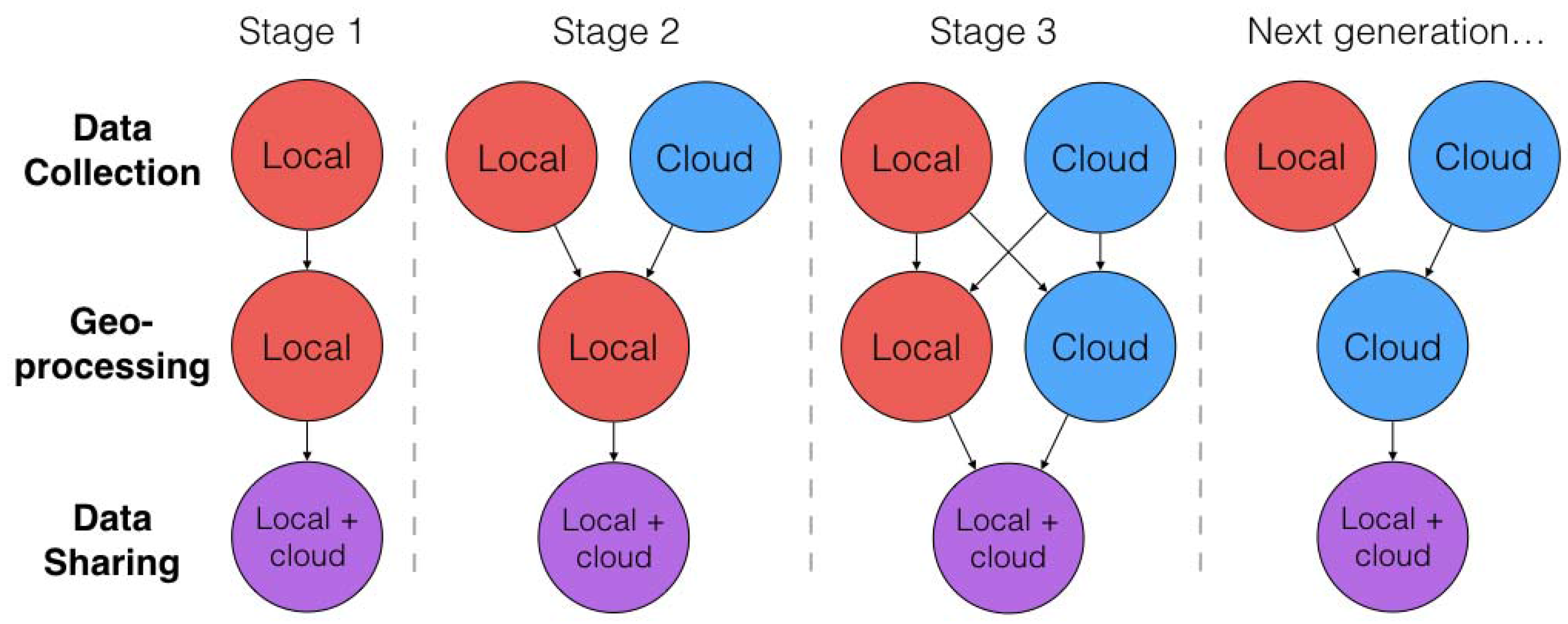
To understand the historical transformation of GIS technology, the conceptual GIS evolution process can be illustrated, as shown in
Figure 1. The evolution process in GIS has undergone at least four transformation stages which can be abstracted into three sub-processes (i.e., data collection, geoprocessing, and data sharing) of the entire spatial analysis process. The pattern of the entire spatial analysis process at each transformation stage is also illustrated in
Figure 1.
In the inception stage (stage 1), due to limited computing resources and technology, both data collection and geoprocessing could only be done by a local client. With the emergence of Internet, people could access more types of the dataset from the cloud storage to enrich their approaches, although geoprocessing was still limited to local clients (stage 2). The first two stages represent the typical mainframe and desktop (stand-alone) GISystems. The third stage (stage 3), which represents the present-day distributed GIServices has benefited from the current Internet web and mobile services, as well as accessibility to cloud big data and the power of cloud geoprocessing. This has allowed users to construct the mashup GIS framework based on the patterns from the previous two stages (stages 1 and 2) [
23]. With the distributed GIServices (i.e., stage 3), everyone can access the immense cloud geographic data as they want, and the massive cloud computing lets the user do the heavy geoprocessing faster than any local client. Furthermore, in the fourth stage, referred to as the next generation, all the geoprocessing has been moved to cloud-based processing. A good example of a cloud-computing platform that applies the next generation pattern is the Google Earth Engine (
https://earthengine.google.com/), which is used for processing huge raster satellite imagery by Google Inc (Mountain View, CA, USA). The MEGA-WEB platform presented in this paper uses the mashup pattern solution (stage 3), applying both local and cloud geoprocessing to establish the GIServices. Details of the MEGA-WEB system architecture are described in the following section.
3. System Design
3.1. Overview of MEGA-WEB System Architecture
The MEGA-WEB platform was designed and developed following a prototyping methodology to mashup the MEGA-WEB Geo Web Services (GWS) with the third-party map services using HTML5/JavaScript techniques [
22]. The development of such GWS and web mapping technologies is a recent tendency in geoscience. Most modern GWS adopts three-tier client-server architecture for system implementation [
19,
24,
25], that includes a user interface tier, Web Services (WS) tier, and data server tier. However, in contrast to the traditional three-level architecture, platforms with massive spatial querying utilize an additional tier for extracting the GWS from the traditional WS tier, to an independent GWS tier as a four-level client-server architecture [
13].
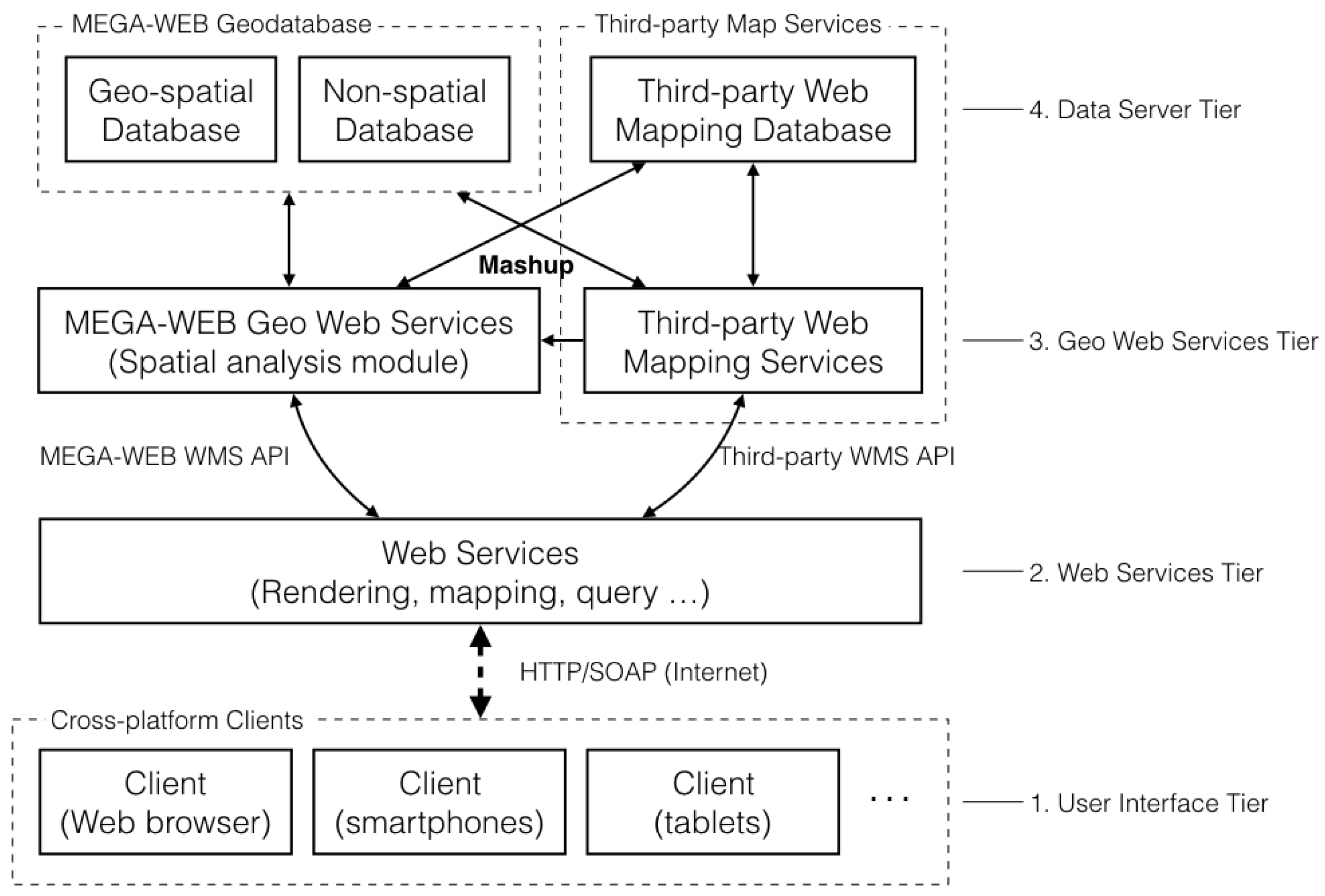
Figure 2 illustrates the conceptual architecture of MEGA-WEB, which is built on a four-tier architecture implementation system. The first tier is the user interface, which provides the visualization of processed results of both spatial and non-spatial information. Unlike the desktop GISystems that are platform-dependent, the user can access the GWSs in a cross-platform environment with the HTTP/SOAP which is one of the protocol specifications for exchanging structured information in the implementation of WSs. Other modern GISystems also use available architectures to provide the web services, i.e., Representation State Transfer (REST) and JavaScript Object Notation (JSON). The second tier is the WS which functions as a communication bridge between the clients and geoweb server. The geoweb server operates as the gate to the GWSs and acts as the final level for map visualization and rendering. MEGA-WEB uses HTML5/JavaScript, which enables the users to get the queried results without going back to the server. This makes the communication process faster than traditional client-server models. The start-up and data transmission time in the traditional client-server model is usually longer. Another technique is the Rich Internet Application (RIA) technique. However, to use RIA, clients need to install an external plug-in. This is not required from clients using HTML5/JavaScript. According to the rendering service categories, as defined by [
26], there are three types of architecture based on the weight of the components. MEGA-WEB is the “thick” type, which has a robust client-side rendering function. The third tier is the GWS tier where the spatial analysis modules are carried out and enveloped. MEGA-WEB utilizes a mashup framework [
25] to merge the third-party map services with the MEGA-WEB original GWS (including the cloud database). However, some of the support third-party map services libraries are discontinued, in consideration of the stability, expansibility, and supported service types [
22]. MEGA-WEB utilizes the Google Maps’ GWS (
https://developers.google.com/maps/) as the third-party WS. It also utilizes Apache HTTP Server components (
https://httpd.apache.org/) as a free and open source (FOSS) service. Finally, the fourth tier, which is the data server tier, includes the spatial and non-spatial database servers. For the spatial database, two types of the spatial data models are stored; the raster and vector data models. MEGA-WEB builds the geodatabase that includes both processed spatial and non-spatial data.
3.2. Selected Asian and African Major Cities
To create the MEGA-WEB GIS platform for visualization and data sharing, 42 Asian and African major cities experiencing rapid urbanization were selected. Major cities in Asian and African countries are reported to have relatively high rates of urbanization due to dominant concentration of population, and industrial and economic activities [
2].
Table 1 shows the selected Asian and Africa major cities for the MEGA-WEB GIS platform.
3.3. Creating the MEGA-WEB Geodatabase
The MEGA-WEB geodatabase was created based on the premise of visualizing, analyzing, and sharing data from scientifically proven indicators of urbanization trends in the literature. The indicators include; Urban Land Use/Cover (LUC) and LUC changes (LUCC), Population distribution (POP), Land Surface Temperature (LST), Energy Consumption Intensity (ECI), and predicted future LUC. Several researchers in the literature have highlighted the importance of mapping and quantifying urban LUCC over time to visualize and understand the urbanization process (e.g., [
27,
28,
29,
30,
31,
32]). Population growth is also known to be one of the key indicators of urbanization in both Asian and African major cities [
2], while LST is one of the key indicators of the impacts of rapid urbanization on the environment and the population, due to the urban heat island (UHI) effect [
33]. On the other hand, the distribution of urbanization strongly and relatively affects the energy consumption of different cities [
34].
The indicators (above), therefore, provide diverse perspectives on urbanization of not only the physical land surface condition, but also the relationships of population, energy use, and the environment with the urbanization process.
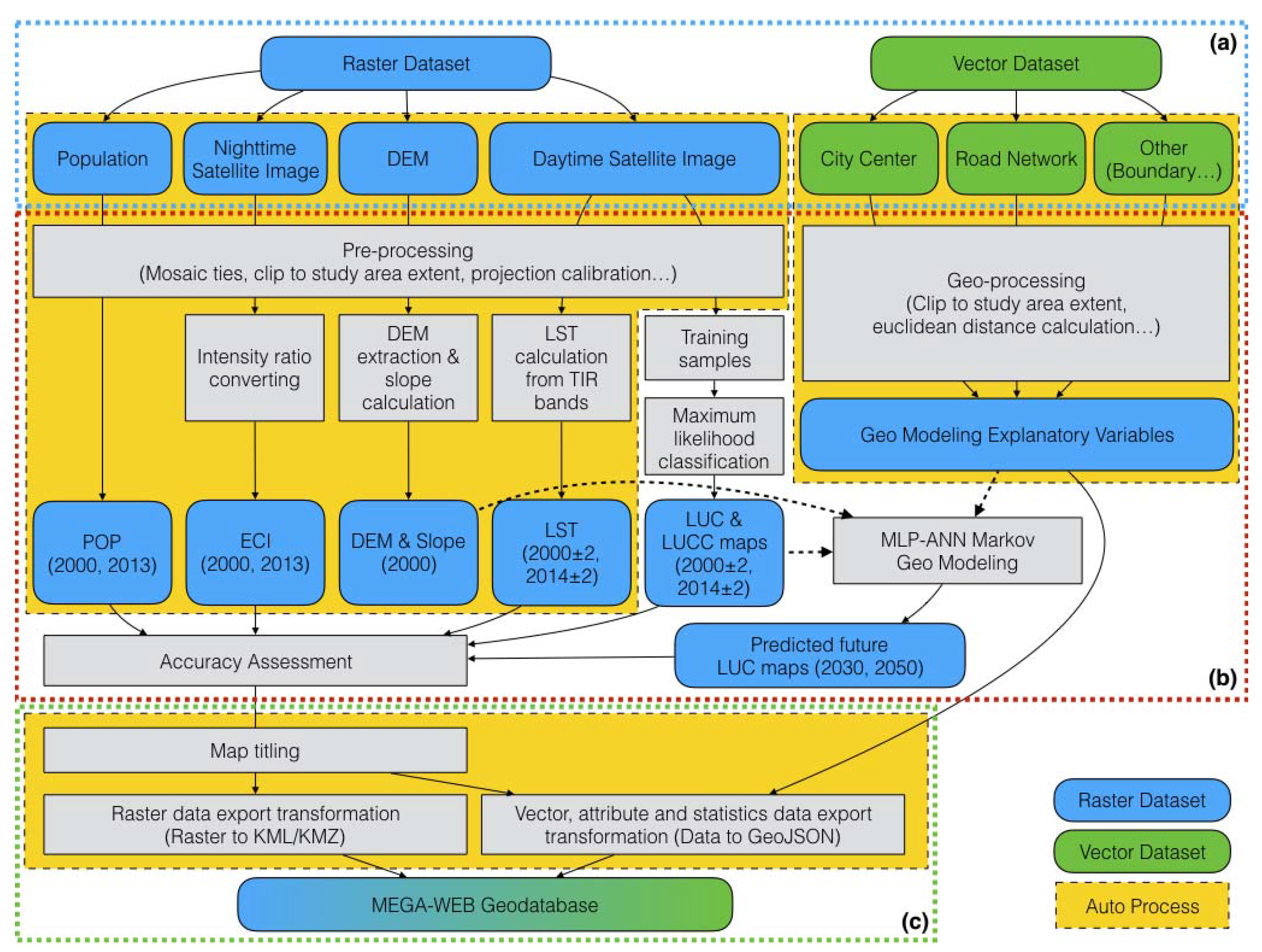
Figure 3 shows the process of creating the MEGA-WEB geodatabase. The whole process comprises of three main steps: (a) data acquisition; (b) geoprocessing; and, (c) data conversion.
3.3.1. Data Acquisition
Several data sources were utilized to obtain vector and raster data for mapping and quantifying the urban LUC, LUCC, POP, LST, ECI, and predicted future LUC in all of the 42 selected Asian and African major cities. Vector data included mainly city administrative boundaries and road networks obtained from the DIVA-GIS website (
http://diva-gis.org/Data) that provides the uniform standards of free spatial data for the whole world. The various raster data collected and their sources are shown in
Figure 3a and described in
Table 2.
3.3.2. Geoprocessing
The data acquired for creating the MEGA-WEB geodatabase was geo-processed using two procedures: automatic batch geoprocessing and specialist-based semi-auto geoprocessing. The two procedures were adopted to reduce complexity and requirements for individual manual effort for efficient geo-processing and handling of the huge MEGA-WEB geodatabase, and thus reduce the potential for errors. To apply automatic batch geoprocessing, Python programming language was used to build automatic batch processing tools based on the ESRI ArcGIS Python Application Program Interface (API) (yellow background color in
Figure 3). The tools were used to automatically process the indicators for respective cities as a batch. Worth noting is that the geoprocessing of the acquired data to produce the chosen urbanization indicators (i.e., past, present and future LUC, LUCC, POP, LST, and ECI) for the MEGA-WEB platform was conducted by specialists in various GIS and remote sensing techniques to achieve acceptable accuracy in the products. The specialist-based semi-auto geo-processing (
Figure 3b) involved the following procedures.
LUC Classification
For the purpose of LUC mapping, eight LUC categories were considered: urban dense, urban sparse, forest, cropland, grassland, bareland, water, and other land. The other land class included clouds, shadow, and snow. A common unit of analysis i.e., a 100 km × 100 km subset of each city was then chosen for the purpose of consistency and comparison. Subsequently, using the Landsat data, the area of each city was clipped to 100 km × 100 km, processed, and classified into the eight LUC classes given above. The pixel-based maximum likelihood supervised classification method was applied in ArcGIS (Version 4.0, ESRI, Redlands, CA, USA) to classify each city. Finally, LUC maps for two time points (i.e., 2000 ± 2 and 2014 ± 2) were produced for each city. Details of the LUC classification methods used for this project can be found in [
35] and on the MEGA-WEB platform online.
LUC Geo-Modelling and Future Prediction
The following literature highlights the importance of LUC geo-modelling and future prediction to a wide range of stakeholders including scientists, urban planners, policy makers, and various other decision makers [
36,
37,
38,
39]. For this project, the Land Change Modeler (LCM) provided in TerrSet Geospatial Monitoring and Modelling Software (
https://clarklabs.org/download/) was used to apply the MLP-ANN Markov modelling procedure to model and predict future LUC for each city. The MLP-ANN Markov modelling procedure in the LCM uses mainly two processes: (1) transition potential mapping i.e., the transition potential of each LUC to change to another (e.g., forest to built-up); and, (2) change prediction (i.e., spatially allocating the predicted quantities of LUC changes using the modeled transitions) [
38,
39]. In this project, the MLP-ANN model was used for creating the transition potential maps using the LUC maps (i.e., 2000 ± 2 and 2014 ± 2) and selected explanatory variables. The explanatory variables include: distance to each of the LUC classes (built-up, forest, cropland, grassland, bareland, and water); distance to roads; distance to city center; as well as the DEM and slope maps of each city. Based on the transition potential maps, the quantity of LUC changes for 2030 and 2050 was predicted using the Markov model. Then, the Markov model was further used to spatially allocate the predicted quantities of LUC changes using the modeled transitions. Finally, two predicted LUC maps for 2030 and 2050 were produced for each city.
LST Calculation and Mapping
Cities have the ability to modify their thermal environment, and the most significant modification is the creation of urban heat islands phenomena during the urbanization [
40]. The usefulness of remote sensing satellite data in studying the urban heat island effect through examining the relationships between urban landscape patterns and LST has been proven in many urban environmental studies [
33,
41,
42,
43,
44]. The method described by [
42] while citing various other sources was used to retrieve the LST from the Landsat datasets for each city. The method involved three main steps: (1) converting the Digital Number (DN) values of the thermal bands (Band 6 in Landsat TM and ETM+, and Bands 10 and 11 in Landsat OLI/TIRS) into absolute radiance values; (2) converting radiance values to satellite brightness temperature (i.e., blackbody temperature); and, (3) converting the satellite brightness temperature to LST. Finally, two LST maps for the years 2000 ± 2 and 2014 ± 2 were produced for each city.
ECI Distribution Map
In order to show the spatial distribution energy consumption in each city, the annual average visible, stable lights, and cloud free coverages of the DMSP-OLS nighttime satellite image data was utilized to produce ECI distribution maps. As the dataset was provided on a global scale, clipping, resampling, and projecting to the respective coordinate systems for each city was conducted. Thereafter, the DN for each pixel representing the unit of light frequency in each pixel was then converted using an intensity ratio out of 100 (i.e., as a fraction of 100) to display the ECI distribution in percent units. Two ECI distribution maps for the years 2000 and 2013 were produced for each city.
POP Distribution Maps
LandScan population datasets (
http://web.ornl.gov/sci/landscan/) were used to produce POP distribution maps for each city. LandScan is a global population database developed by the Oak Ridge National Laboratory (ORNL), and represents a worldwide ambient population distribution (average over 24 h) with a fine resolution of approximately 1 km resolution [
45]. The auto batch process was applied to extract each city area from the global scale map for each city. Two POP distribution maps (2000 and 2013) were made for each city.
3.3.3. Data Conversion
The MEGA-WEB GIS platform was developed based on a mashup GWS architecture model (
Section 3.1 above), with the aim of making the geo-processed data available online for visualization and downloading. For the data to be accessed online and downloaded, the MEGA-WEB GWS needs to connect with the third-party GWS open standard data formats for representing geographical features, such as Keyhole Markup Language (KML) and GeoJSON. KML, Zipped KML (KMZ) is a generally recognized data format providing geoscientists with an innovative data format to enclose the spatial data [
46,
47]. In order to enhance the user experience for web mapping, map tiling was simultaneously processed together with KML data conversion. Map tiling was managed using MapTiler Software (version 7.2, Klokan Technologies, Unterageri, Switzerland). In spite of KML being able to support many kinds of data formats, including vector and raster data types, as a robust expressing geographic annotation data format is not adequate for the dynamic flexible visualization and analysis. On the other hand, GeoJSON supports several geometry types of vector data with flexible visualization and analysis: point, line, polygon, multipoint, multiline, and multi-polygon, along with their non-spatial attributes (
http://geojson.org/). Utilizing both data formats, thus, presents an opportunity to develop an effective geoweb-based Internet application. For the MEGA-WEB project, both the KML/KMZ and GeoJSON data formats were utilized. To balance the deficiency of the KML/KMZ data format, GeoJSON was utilized to manage and encapsulate the vector data and non-spatial data, while KML/KMZ was utilized to encapsulate the raster data. The data conversion workflow for MEGA-WEB is shown in
Figure 3c. Considering the massive size of the MEGA-WEB geodatabase comprising of 42 cities and the amount data conversion required, a python library was developed to transform the final data for visualization and sharing to specific data formats. The data conversion process includes: tiling the raster data; converting raster data to KML/KMZ; extracting non-spatial statistics (attribute) data from raster data to GeoJSON; and, converting vector data to GeoJSON.
3.4. System Platform Implementation
To implement the system online, the MEGA-WEB platform was developed based on the mashup method of the MEGA-WEB GWSs with the third-party GWS, to provide visualization, spatial analysis, different types of background maps, attribute chart information displays, and real-time traffic information for each city considered in this project. The third-party GWS API was used to provide functions for the Google Maps API (GWS and cloud-based data services), Google Charts API (visualization for attribute data in MEGA-WEB geodatabase) and Google Fusion Tables API (spatial information analysis and visualization for vector data). In addition to the Google GWS mashed up in MEGA-WEB, other third-party services like the DataTables table plug-in for jQuery (dynamic non-spatial data interaction control tool) were also used. The following section provides details of the platform in terms of system functions and usage.
4. System Functions and Usage
The previous section (i.e.,
Section 3) described the behind-the-scenes system design and implementation of MEGA-WEB. This section describes the system functions and usage of MEGA-WEB, made available to users using examples. The primary principles of MEGA-WEB are accessible operability for general users, and expandability for specialists, which are introduced hereunder from four aspects: visualization, comparisons analysis, overview analysis, and data downloading.
4.1. MEGA-WEB Dashboard and Interfaces
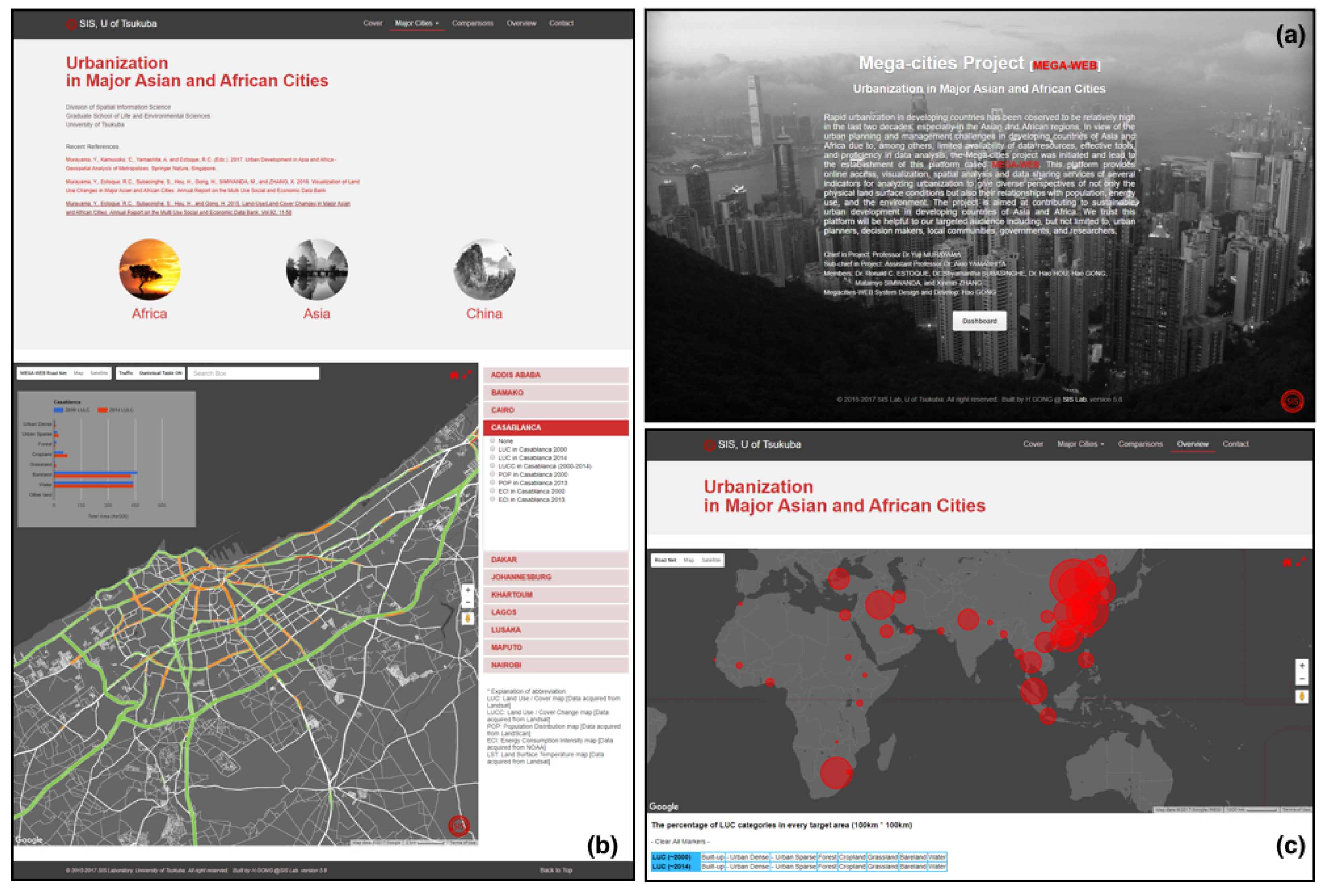
Figure 4 shows the overview of the dashboard and examples of the interfaces provided on the MEGA-WEB website. The MEGA-WEB dashboard can be accessed through the entrance page of the project on the MEGA-WEB website, as shown in
Figure 4a. In the MEGA-WEB dashboard, three main modules have been made available: (1) major cities analysis module (
Figure 4b); (2) comparisons analysis module; and, (3) overview analysis module (
Figure 4c). The main purpose of the major cities analysis module allows users to analyze the urbanization indicators within a single city. The comparison analysis module is provided to allow users to analyze and make comparisons between urbanization indicators within and among cities. The overview analysis module provides the users with functions for overview (all cities) analysis of urbanization in Asia and Africa. The details of the modules are described in the sections hereunder.
4.2. Major Cities Analysis
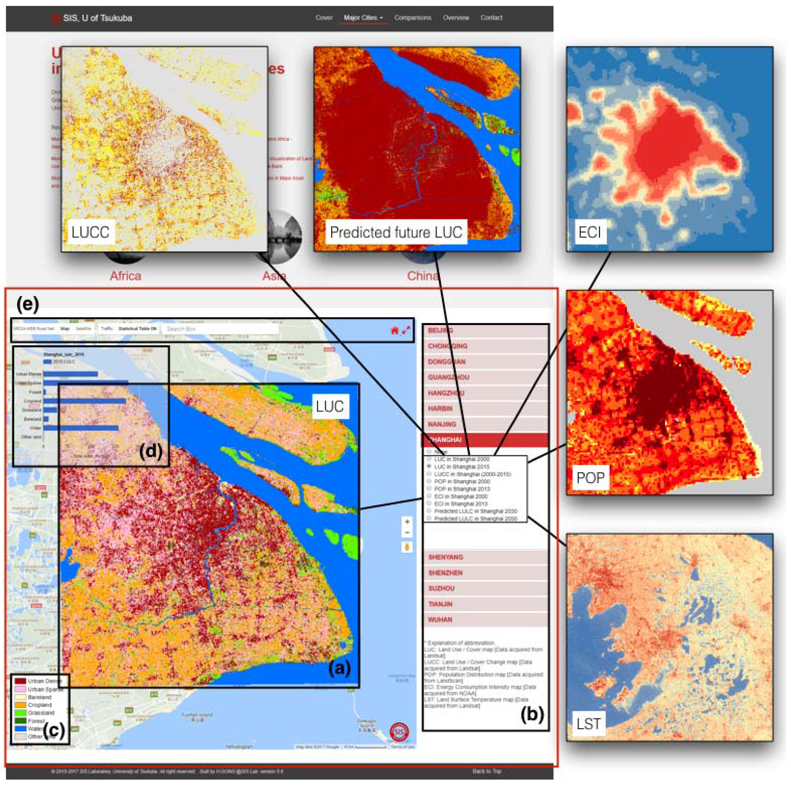
When users access the MEGA-WEB modules through the dashboard, the first thing they see is the major cities analysis modules for Africa, Asia, and China (
Figure 4b). The functions of these modules rely on several components as shown
Figure 5. In order to give the user a holistic view and manage the data more efficiently, a two-level architecture (continent level and city level) was used to manage the entire target cities.
For a respective city, six urbanization indicators (i.e., LUC, LUCC, ECI, POP, LST and predicted future LUC) described in
Section 3.3.2 are provided (
Figure 5a). From the web mapping interface, represented by the red box in
Figure 5, users can interact directly with the unique spatial objects and GIS features on the MEGA-WEB platform. The interactive map interface (
Figure 5a) includes the urbanization indicators for each city (
Figure 5b), legend information (
Figure 5c), and the paired attribute data (
Figure 5d). GIS features and map-rendering functions, such as zoom, pan, and various background map types realized using third-party services are also provided. In addition, we developed and embedded some more GIS functions into the interactive user interfaces such as thematic road network map, real-time traffic maps, statistics data control functions, floating attribute view, and home/enlarge control functions (
Figure 5e).
4.3. Comparisons Analysis
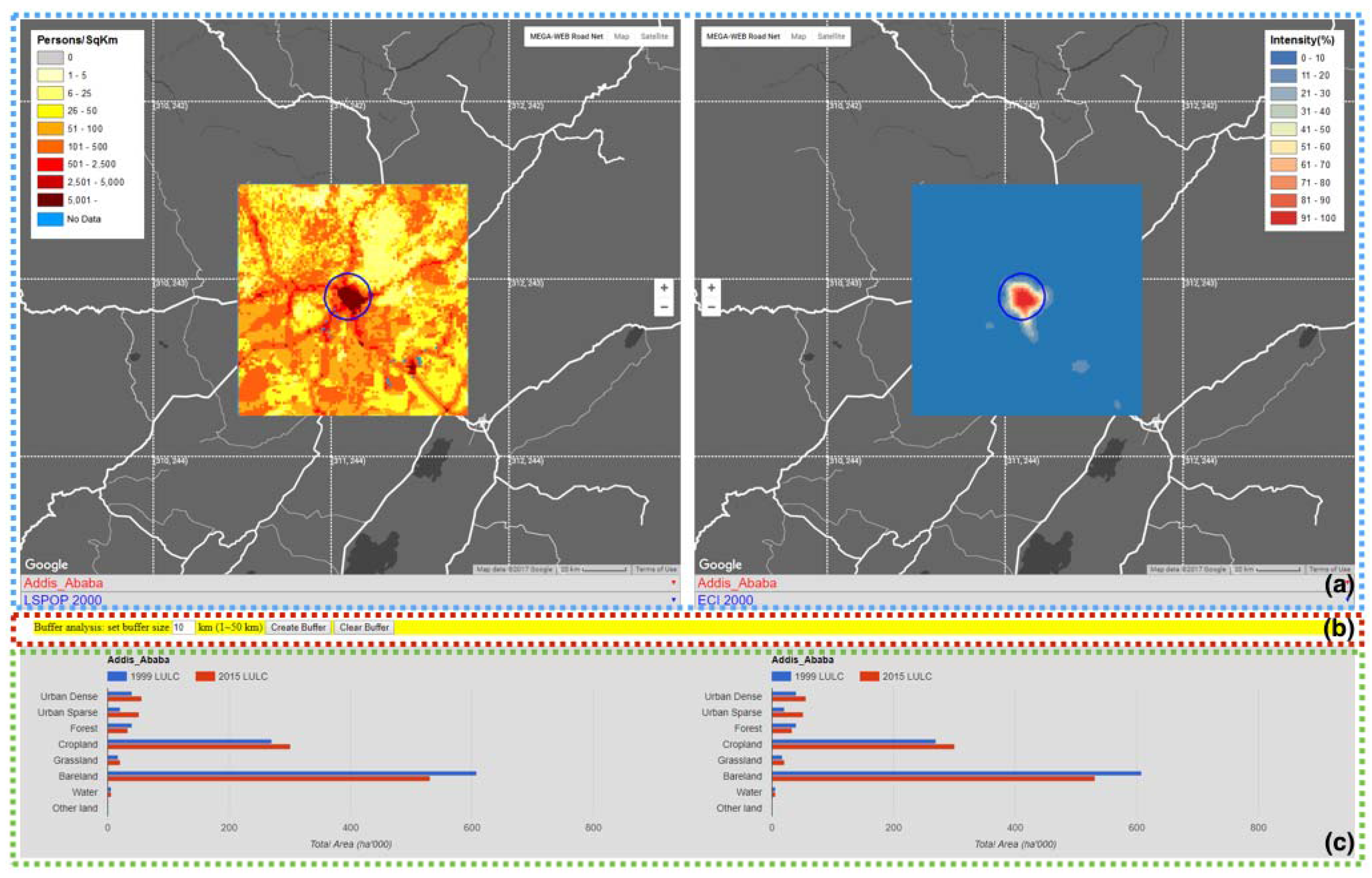
As indicated above, the comparisons analysis module is meant for users to evaluate urbanization indicators within and between cities (
Figure 6). In this module, the users can evaluate the changes within their respective cities, as well as learn from other cities in the same or other region, thus enabling them to have an even more diverse perspective on both local and regional urbanization. A buffer analysis tool is also provided for users to define a buffer area of interest, and make comparisons within a specific extent (
Figure 6b). This can be very helpful in analyzing the urban-rural gradient in most cities. Furthermore, the module provides statistics of the eight LUC categories for respective cities (
Figure 6c).
The advantage of the comparisons module is that it reduces the amount of effort and time that would be required to conduct similar analysis when using the traditional desktop (stand-alone) GISystems. For example,
Figure 6 shows one case of the comparisons analysis to assess the correlation between two indicators (POP and ECI) for one city. In this example the user can quickly have an idea of how the changes in population have affected the changes in energy consumption in the city.
4.4. Overview Analysis
In order to minimize the user input and to simplify the output report, in addition to single city and multiple cities (comparisons module) analysis, MEGA-WEB provides the users with functions for an overview (all cities) analysis of urbanization in Asia and Africa (See
Figure 4c).
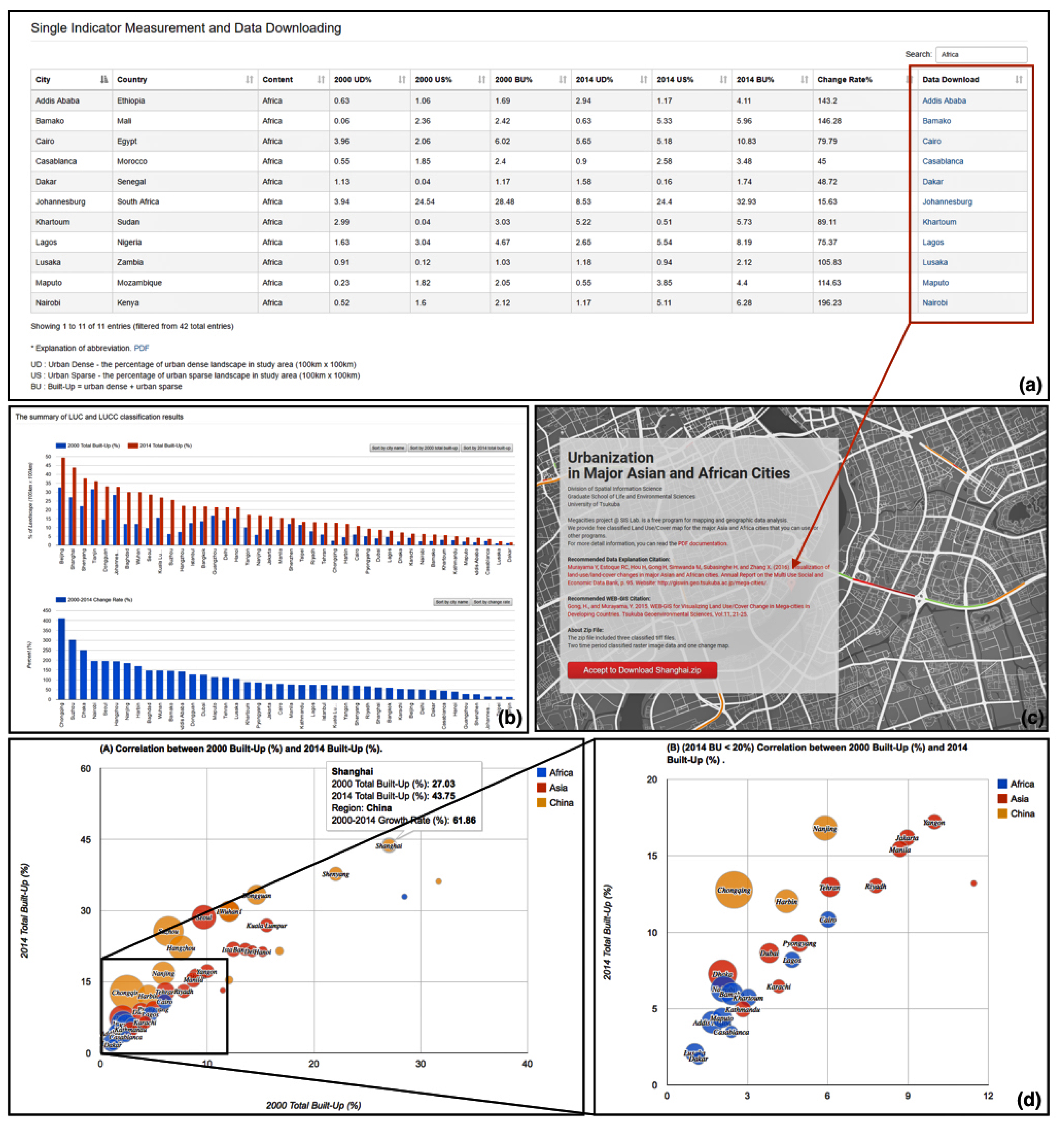
Figure 7 shows the system functions for the overview analysis module, which provides the prototypical interactive tools that summarize the MEGA-WEB geodatabase. Through this module, users can visualize and get the thematic urban spatial changes and general trends in Asia and Africa.
In order to get a holistic view of all 42 major cities, the user can visualize the changes of all categories through a global view map, as shown in
Figure 4c. The built-up class, as well as its sub-classes (urban dense and urban sparse) are also presented as single indicator measurements of urban expansion (
Figure 7a). To get the ranking of the major cities in developing countries, bar charts of the built-up percentage and its change rates in each city for two time points (i.e., 2000 ± 2 and 2014 ± 2) are provided to the users, as shown in
Figure 7b. The user is also provided with a tool to explore the relationship between cities in two temporal dimensions (referred to as Multidimensional Measurements), as shown in
Figure 7d.
4.5. Data Downloading
In order to empower users, sharing the data contained in the MEGA-WEB geodatabase is one of the most significant parts of the project. In view of the urban planning challenges faced by users in developing countries of Asia and Africa due to, among others, the limited availability of data resources, effective tools and proficiency in data analysis, the MEGA-WEB project has attempted to overcome these challenges by providing a download option. The data download function can be accessed by users through the overview analysis module. The red box in
Figure 7a shows the location of the data download function. The user is simply required to select any city of their interest to enter the data download interface as shown in
Figure 7c. The data download interface contains all of the instructions for downloading the data. The data available for download include the LUC, LUCC, ECI, LST, and predicted future LUC maps for each city, which is provided in a zip file. The data is in Geo Tagged Image File (GeoTIFF) format which is widely supported by most GIS software. Therefore, the users can download the data provided and use it for further analysis.
5. Discussion
The MEGA-WEB project is focused on urbanization in major cities of developing Asian and African countries to contribute to sustainable urban development. From a scientific standpoint, the contribution of this project is twofold.
Firstly, to provide a diverse perspective of urbanization, MEGA-WEB provides a geodatabase of important urbanization indicators (i.e., past and present LUC, LUCC, POP, LST, ECI, and future LUC), processed by using scientifically proven methodologies applied in remote sensing and GIS (see
Section 3.3.2). Understanding the spatiotemporal patterns of LUC or LUCC is necessary for making rational economic, social, and environmental policies that can mitigate the negative effects of urbanization on the environment, and maintain optimal ecosystem functioning [
30,
48]. Also, examining the spatiotemporal patterns of LUC or LUCC together with LST provides an opportunity to understand the UHI phenomenon in the major cities of Asia and Africa. In fact, in the context of Africa, very few studies exist on the UHI effects. The UHI effects are responsible for some negative impacts of urbanization, such as increased energy consumption, increased emissions of air pollutants and greenhouse gasses, compromised human health and comfort, and impaired water quality (Voogt, 2004; EPA, 2008 in [
42]). Thus, MEGA-WEB also provides processed data on energy consumption (i.e., ECI) and human population (i.e., POP). Therefore, the MEGA-WEB project has the potential to contribute not only to sustainable urban development, but also to social and economic development in Asian and African cities. Indeed, some individual studies assessing one or two indicators in the cities considered by the MEGA-WEB project exist. Still, to our knowledge, there are no projects that have processed such huge datasets of these specific urbanization indicators in Asia and Africa, and made them available to the public freely. Assessing the above indicators in one platform gives the opportunity to urban planners and policy makers to understand the urbanization trends locally, as well as learn from regional trends.
Notwithstanding the success and benefits of MEGA-WEB, we acknowledge some challenges that come with such an undertaking. For, example geo-processing of data was very challenging due to the technical issues (including the ‘seasonal difference’ between the satellite images used, the presence of clouds, shadows, ships and snows, spectral confusion between LUC categories, and the inherent complex nature of each city’s landscape pattern) and the insufficiency of prior knowledge in the specialist-based semi-auto geoprocessing for some target cities. In addition, only one scenario of future LUC simulation (urban expanding without control) has been considered, although considering more than one future scenario would be more insightful. Nevertheless, we paid careful attention to these issues during the data process, with the aim of producing accurate results. Moreover, unlike other projects that rely on datasets provided by other organizations, the MEGA-WEB geodatabase is generated by ourselves, and this provides a good opportunity to make improvements in the future, if necessary.
Secondly, MEGA-WEB is focused on the use of Internet-GIS techniques to study and share the knowledge of urbanization in Asia and Africa to the public. Compared with traditional desktop GISystems and software, MEGA-WEB provides a non-platform dependent and widely accessible system for urbanization studies, which remarkably reduces the threshold for physical, technique, and funds requirements. From the technical perspective, the developed architecture and functionality has some unique features that can be easily used to develop new extensions and functions. For instance, the mashup architecture (particularly using HTML5/JavaScript techniques) provides high flexibility and expandability in the system developing, which could be a reference for readers to develop similar applications. Additionally, based on a number of lessons learned and feedback from general users, the analysis modules in MEGA-WEB are provided in a progressive way (single city analysis, multiple cities analysis, and all cities analysis) without too complex functions. Furthermore, for users that might require more advanced spatial analysis functionality, MEGA-WEB allows users to download the data for the further analysis.
6. Conclusions and Future Works
In this paper, we presented an Internet-based GIS platform called MEGA-WEB for data sharing, visualization, and spatial analysis of urbanization in major Asian and African cities. The MEGA-WEB platform was developed to assist in overcoming the challenges of the urban planning and management challenges (e.g., limited availability of data resources, effective tools, and proficiency in data analysis) in developing countries of Asia and Africa. The targeted audience is, but not limited to, urban planners, decision makers, local communities, governments, and researchers.
The platform was designed and developed following a prototyping methodology to mashup the MEGA-WEB Geo Web Services (GWS) with third-party map services, to make geo-processed data on urbanization available online for visualization, analysis, and downloading. With the integration of GIS, remote sensing, land cover change geo-modelling, and Internet GIS, we used specialist-based semi-auto geoprocessing and automatic batch geoprocessing procedures to create the MEGA-WEB geodatabase for 42 major cities in Asia and Africa. The MEGA-WEB geodatabase comprises of processed data from scientifically proven indicators of urbanization trends in the literature. The indicators for measuring the urbanization provided by MEGA-WEB includes: LUC, LUCC, POP, LST, ECI, and predicted future LUC.
The main features of MEGA-WEB are its visualization, spatial analysis interfaces, and data sharing system. Three main modules have been made available: (1) major cities analysis module; (2) comparisons analysis module; and, (3) overview analysis module. Through these modules, the change tendencies of urbanization are presented in a progressive way, from a general idea of the single city to the overview of the major cities in Asian and African developing countries. To empower the targeted audience, MEGA-WEB also provides a download service for users to download the data provided and use it for further analysis.
The MEGA-WEB is now available on the following site:
http://giswin.geo.tsukuba.ac.jp/mega-cities. Worth noting is that MEGA-WEB is always open to future improvements, including data provision or updating, as well as the development of new system functions and extensions. Some of the future plans to improve MEGA-WEB include: (1) improving the geoprocessed products through the use of other additional dataset (e.g., high-resolution imagery and social network data); (2) increasing the numbers of the target major cities across the Asian and African regions; (3) providing more Internet-based spatial analysis functions; (4) providing support functions for users to upload their work and interact with others; and, (5) inviting key stakeholders in the targeted cities’ to provide feedback on the usefulness of MEGA-WEB and suggest more future improvements.
