Article

WebGIS for Geography Education: Towards a GeoCapabilities Approach

UCL Institute of Education, University College London, London WC1H0AL, UK
ISPRS Int. J. Geo-Inf. 2018, 7(3), 111; https://doi.org/10.3390/ijgi7030111
Submission received: 11 January 2018 / Revised: 1 March 2018 / Accepted: 12 March 2018 / Published: 15 March 2018

Abstract

:
Recent developments in webGIS are transforming how geospatial information can be used in schools. Smart mapping, mobile applications, editable feature services (EFS), and web map services (WMS) are all now more freely available. These have made prior technological, cost and access challenges for teachers largely redundant but are only part of ensuring that geospatial information is used to its full educational potential in geography education. This paper argues that drawing on a GeoCapabilities approach can enhance teacher’s use of webGIS in deepening their students’ abilities to think and reason with geographical knowledge and ideas. To illustrate this line of argument, a geography curriculum artefact constructed in ArcGIS Online is presented and analysed. The discussion identifies a range of specific educational benefits of geography teachers adopting a GeoCapabilities approach to using webGIS including how powerful disciplinary knowledge (PDK) can be constructed. The discussion also identifies a number of significant implications for teacher education of adopting such a methodology. The paper concludes with recommendations for the future use of webGIS in schools and geography teacher education.

1. Introduction

Drawing on the notion of GeoCapabilities [1], this paper argues for a progressive, subject knowledge-led approach to teaching school geography with webGIS. The paper begins with a background section on the use of GIS in geography education. This discussion highlights the historical contribution of GIS to spatial analysis, enquiry-based learning, geovisualisation and the development of geospatial skills in geography. The more recent developments associated with the advent of webGIS are then considered. These include smart mapping [2], open source data, new mobile web tools and specific applications such as story mapping [3].
A case is then made for geography teachers developing a subject-led approach to their use of webGIS in the classroom. The principles of a capabilities approach to education are then introduced. Four key concepts associated with GeoCapabilities: powerful disciplinary knowledge (PDK) [4] a progressive, Future 3 curriculum [5] curriculum making [6] and curriculum artefacts [7] are then examined.
A discussion on how a GeoCapabilities approach can be used to teach about a specific geographical topic, the 2004 Indian Ocean Earthquake and Tsunami follows. A curriculum artefact centred on the event and built in ESRI ArcGIS Online according to GeoCapabilities principles is then presented and discussed. The artefact is discussed using Maude’s typology of powerful geography knowledge as an analytical framework [8]. The paper concludes by drawing on evidence from these assessments and making recommendations for future geography curriculum making and teacher education with webGIS through a GeoCapabilities approach.

2. GIS in Geography Education

Geographical information systems (GIS) allow a user to map and ask questions of data about spatial relationships in ways that cannot usually be readily accessed outside of a GIS. GIS can be used to store, analyze and display a range of geo-referenced data such as maps, satellite and photographic images, tables and graphs. Evidence reflecting the educational benefits of using GIS is wide-ranging. GIS in geography education has a long history of being used to develop spatial thinking [9], promote enquiry-based learning [10], supplement geography fieldwork [11] and enhance student’s visualisation of geographical phenomena through digital interactive environments [12].
When used to its full potential GIS can provide comprehensive learning environments with proven potential for studying geographical problems, issues and events of real world relevance [13]. As a result, GIS is considered to have special significance in enquiry-based learning. GIS enquiry usually focuses on five types of questions as shown in Table 1 [14].
Enquiry is identified as a key aspect of high quality geography education in several countries [15]. In schools where GIS enquiry is of a high standard, teaching and learning with GIS has moved towards a deeper type of questioning using geographical evidence and involving students in interrogation of ‘the whys of where’ [16]. As a result, GIS is an attractive proposition for most geography teachers. However, in the past, many teachers have found lack of experience, training, high costs and poor access to GIS difficult to manage [17]. The move of GIS to the web is changing this situation for the better. The next section considers these new opportunities for teachers.

2.1. WebGIS

Though not often used in schools at the time, webGIS first became available in the early 1990s. Xerox Park Map Viewer [18] was one of the earliest web mapping sites to provide interactive information online. Other webGIS were to follow in quick succession with Worldwide Earthquake Locator [19] being the first web mapper to use mashed up data from a variety of sources. WebGIS have been used in school education since the mid-1990s when science-based educational networks such as GLOBE [20], KanCRN [21] and Journey North [22] used webGIS to collect, analyse and map data [23].
For school geography, the move of GIS to the web has largely removed previous obstacles of difficult software installation and limited hardware capacity. Web-based mapping platforms such as ESRI ArcGIS Online [24] and QGIS, [25] a free open source GIS with web capability are now much more commonplace in schools.
Web mapping is more intuitive than previous versions of GIS with user-friendly interfaces which do not require a great deal of expert GIS knowledge to use. Geospatial information can be accessed through a web browser which allows for use via desktops, tablets and smartphones. At the same time, a vast array of geospatial information can be accessed through a range of geospatial organisations on the web. Whereas in the past a user would need to ask questions individually of data in desktop GIS, webGIS is much more dynamic, responding to a range of questions and making deeper questioning of geographical data much easier to achieve.
Releasing teachers from the constraints of physical GIS software and giving them access to online data has therefore given them more scope for using GIS successfully. It can be argued that three developments in the use of webGIS in schools are most significant for geography teachers. These are smart mapping, open source data and updated mobile applications.

2.1.1. Smart Mapping

One of the most significant innovations for teachers has been the introduction of smart mapping to GIS. Smart mapping is a capacity built into ESRI ArcGIS Online which allows expert and novice users alike to produce professional quality maps quickly and easily regardless of their prior knowledge of geographical information systems (GIS). Offering automatic ‘smart’ defaults, ArcGIS Online analyses a user’s data to offer a ‘best fit’ for their choice of map, analysis or presentation. For teachers using geospatial data in schools this has been a revolutionary step forward as time spent grappling with the more complex techniques associated with GIS has largely become a thing of the past. Figure 1 shows the application of smart mapping to plot earthquake magnitudes [26].

2.1.2. Open Source Data

The impact of open source data on the use of geospatial applications in schools has also become increasingly significant. Specialised applications such as EDINA’s DigiMap OpenStream provide free web map services (WMS) to the academic community and schools alike, making geospatial data easier to use and process than ever before [27].
Figure 2 shows an example of using EDINA’s MapStream for Schools web map service (WMS) to investigate the controversial issue of fracking. This combines a range of geographical data using Ordnance Survey, Open Street Map, Google Maps Satellite and Google Streetview to enable the user to interact with a wide variety of maps, satellite and photographic sources at the same time [28].

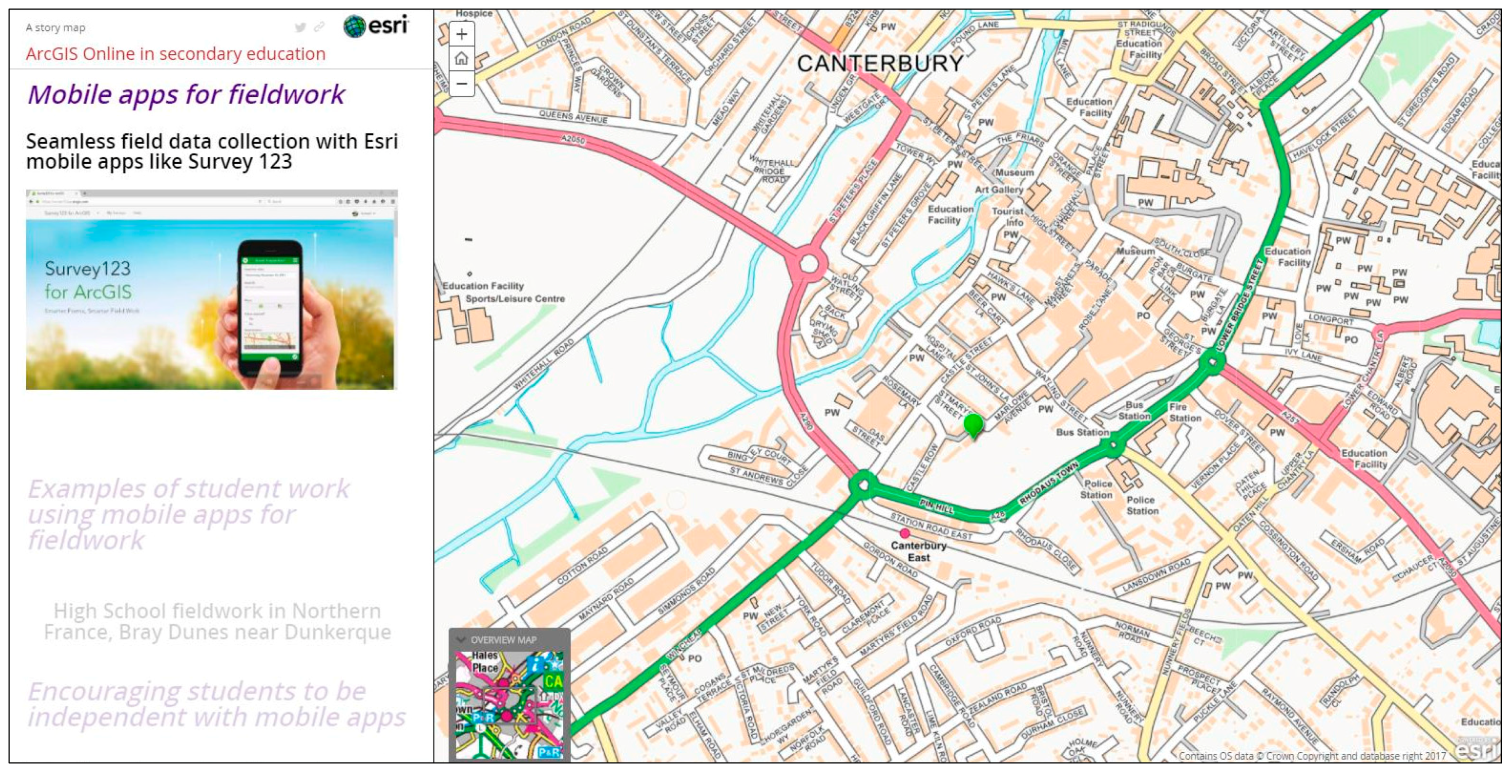
2.1.3. Mobile Applications

Mobile geospatial technologies have a well-established history in school education. Since the very early days of using GPS, teachers in science and geography in particular have taken advantage of using global positioning to collect, map and analyse geo-located data and develop their students’ spatial skills accordingly. One of the major innovations in the use of webGIS in schools has been the development of much more flexible cloud-based mobile applications such as ESRI Survey 123 for ArcGIS. These applications can allow teachers and their pupils to collect their data in a systematic way through editable feature services (EFS) and allow teachers to assign their pupils to collect data individually or collaboratively through any smart-enabled mobile devices [29]. EFS enables teachers to design fieldwork with mobile applications so that they can control how, where and what their students collect whilst out in the field, eliminating much of the previous complexity and technological problems associated with using GPS receivers. Data can be collected quickly and efficiently, stored in the cloud and used seamlessly once back in the classroom. Figure 3 shows one such example from work done at Dover Grammar School for Boys in the UK where they are working with the ESRI Survey 123 Web GIS application to carry out urban investigations [30].
Thus far, the paper has discussed the main advantages of using GIS in geography education and the ways in which innovations related to the move to webGIS are starting to have an impact in the classroom. The next section introduces the GeoCapabilities approach to geography education and shows how this could be used to capitalise on the advantages of using webGIS in school geography.

2.2. GeoCapabilities

The Geocapabilities approach to geography education has firm roots in the field of human capabilities development originating from the work of Amartya Sen and Martha Nussbaum on welfare economics and social justice [31]. In their treatise, Sen and Nussbaum encourage deep consideration of the role of education in shaping how an individual thinks and acts, their autonomy and ultimately, their potential. The GeoCapabilities approach also assumes that the expansion of specific human capabilities is followed by human empowerment to think and act in ways that fulfill one’s future prospects. Fundamental to GeoCapabilities thinking is an emphasis on a progressive, subject-led approach to teaching school geography particularly through the development of powerful disciplinary knowledge (PDK) [32].

2.2.1. Powerful Disciplinary Knowledge (PDK)

Powerful disciplinary knowledge originates from the work of Michael Young [33] who argues that school subject knowledge can only be powerful when it enables young people to think in ways beyond their direct experience. Young argues that all young people regardless of background are entitled to be taught this kind of specialist knowledge. It can be argued that young people who have access to powerful disciplinary knowledge and the intellectual capacities they may develop with it are afforded a crucial element of their true human potential. It can also be argued that subject specialist teachers provide the best opportunities for their pupils to be given access to PDK which can be used to enable them to think in distinctive, disciplined ways through a subject’s fundamental concepts.
It is important to be clear on how powerful disciplinary knowledge can be recognized. In his discussion on how to categorize powerful knowledge more specifically, Lambert, discussing geography education, argues that it is important that powerful knowledge is ‘made’ in accordance with a defined rigour and attention to scholarly detail. Powerful knowledge, he argues, is also evidence based, abstract and conceptual and is part of a broader established system of disciplinary thought. Powerful knowledge is also dynamic and evolving but also imminently reliable. It is testable and should be open to challenge. Powerful knowledge may also be counter-intuitive at times and exists outside the everyday or direct experience of the teacher and the learner. In these ways, according to a GeoCapabilities way of thinking, powerful geographical knowledge has a key role to play in an individual’s education [34].
Maude has contributed further to the powerful knowledge debate in geography education by identifying powerful geographical knowledge by the way it is produced and considering the intellectual power it gives to those who have it [35]. Table 2 illustrates Maude’s typology of geography’s powerful knowledge.

2.2.2. Curriculum Futures

Another key way in which a Geocapabilities approach to teaching geography is distinctive in promoting a knowledge-led curriculum is through the use of a ‘curriculum futures’ framework defined as:
  • F1 Subject ‘delivery’: the curriculum as ‘given’. Arranged within traditional subjects with a stable body of core knowledge. This is under-socialised knowledge.
  • F2 Skills, competences and ‘learning to learn’. An approach that considers traditional subject divisions as ‘arbitrary’. Integrated themes and issues are preferred. This is experiential and over-socialised knowledge.
  • F3 Capabilities. Subjects are not ‘given’ or ‘arbitrary’. Knowledge development is led by epistemic rules of recognized subject specialist communities to provide ways to understand the world and take pupils beyond their everyday experience [36].
GeoCapabilities adopts an F3 approach and is therefore underpinned by the belief that knowledge development in schools should be led by subject specialists who are best placed to provide young people with the highest quality geography education. Geography is particularly relevant to a 21st century education where pupils should be given the best intellectual opportunities to become knowledgeable about complex issues such as human-induced climate change, population pressure and complex geo-political shifts to name but a few. The discipline of geography provides meta-concepts or ‘big ideas’ such as place, space and interconnection from which the specialist teacher can draw to prioritise and underpin how they shape the curriculum to engage pupils in thinking geographically in powerful ways [37].
A Future 3 GeoCapabilities approach to geography education fully supports the idea that teachers engage in making a geography curriculum which is knowledge-led and enables young people to think deeply with their geography to make informed and decisions based on robust disciplinary knowledge in an increasingly interdependent and globalised world [38]. A crucial part of this approach is the process of curriculum making.

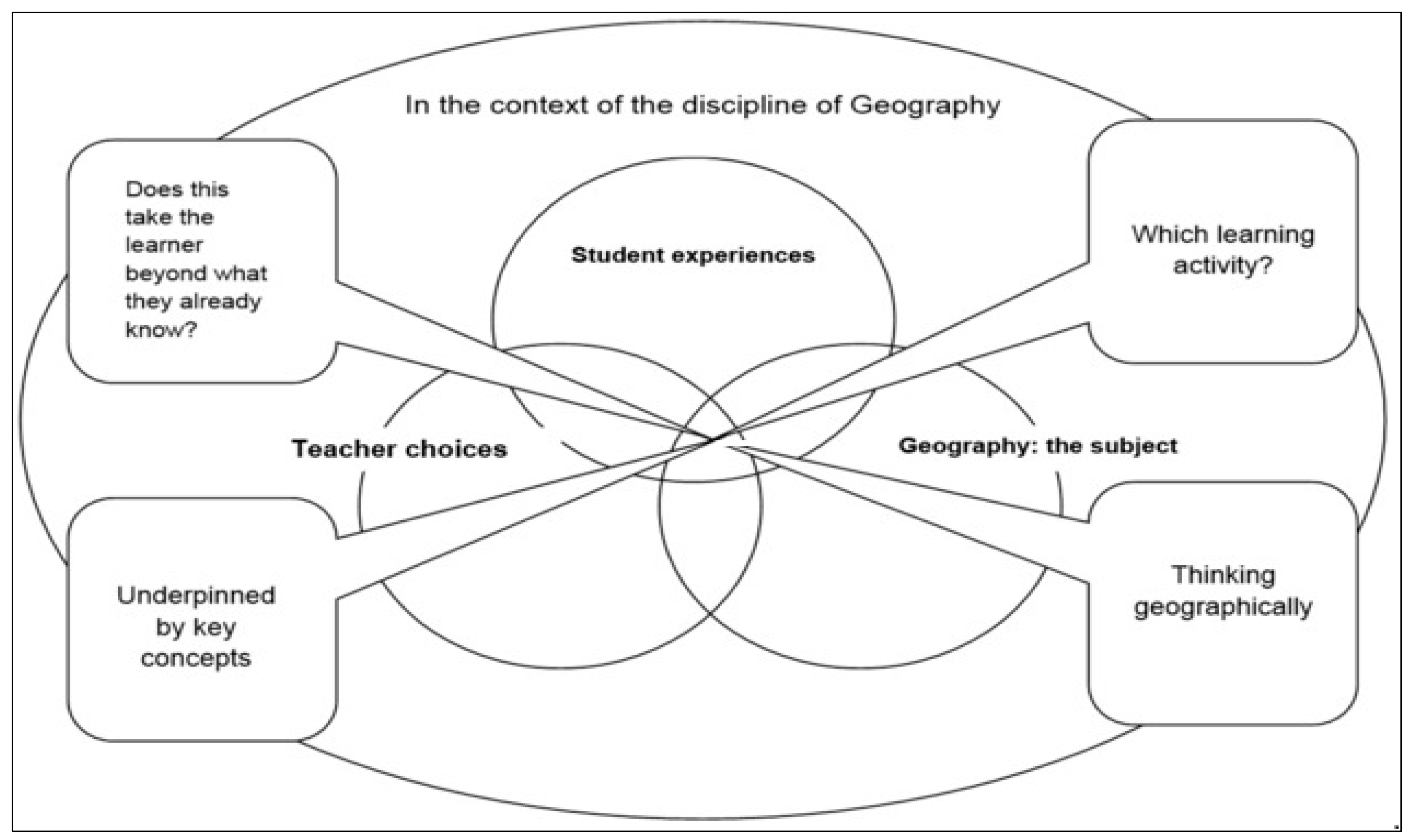
2.2.3. Curriculum Making

Curriculum making lies at the heart of teachers adopting a GeoCapabilities approach. Figure 4 illustrates the main components of the curriculum making model [39].
The model brings together geography the subject, teacher choices and student experiences. It is designed to engage teachers in deep thinking about four balancing and interconnected functions of their curriculum work:
  • Underpinning the curriculum with geography’s key concepts;
  • Taking a the learner beyond what they already know;
  • Choosing learning activities which reflect curricular aims that are adapted to student needs and experiences;
  • Engaging young people in thinking geographically.

2.2.4. Curriculum Artefacts

One approach to making the curriculum is through the creation of a ‘curriculum artefact’. A curriculum artefact is in effect the ‘key’ to a series of lessons on a given topic. This can take the form of a particular resource such as a map, a series of photographs, a set of numerical data, a text or a combination of these. Curriculum artefacts are therefore often multilayered [40]. This paper illustrates how he development of smart mapping, easier access to open source data and mobile GIS applications provide new opportunities for creative geography teachers to develop webGIS curriculum artefacts. The next section explores how webGIS tools were used to construct a geography curriculum artefact (based on the 2004 Indian Ocean Earthquake and Tsunami) via a GeoCapabilities approach.

3. A WebGIS Geography Artefact: Discussion and Analysis

This section draws on Maude’s typology (Table 2) to discuss how an artefact developed in ESRI ArcGIS Online was used to construct powerful geography knowledge about the 2004 Indian Ocean Earthquake and Tsunami.
Table 3 demonstrates the specific connections between Maude’s classification of powerful geography knowledge and the subject-specific pedagogy used with the webGIS artefact. Figure 5 shows the artefact base map.
The artefact base map contains earthquake data on date and time, depth, Richter scale magnitude, Mercalli intensity and duration. Tectonic and human impact summaries are also included as map bookmarks. A range of ‘before’ and ‘after’ photographs and satellite images of specific locations affected are also included.

3.1. Using Interconnection to Explain the Causes of the 2004 Indian Ocean Earthquake (Type 2 Powerful Knowledge)

The geographical concept of interconnection is crucial to unlocking geography’s power to explain causes and effects [41]. GIS has always been used as a system to make connections by mapping attribute data at specific locations. Using GIS to connect data sets on the 2004 Indian Ocean earthquake could enable students to map and visualise a number of significant causal relationships. For example, Figure 6 links local data at the earthquake epicentre with regional data on plate boundary movements. The map also contains a range of data from which students could identify the information required to ask a number of challenging geographical questions (Step 1 in the Steps in GIS Enquiry Process shown in Table 1) about:
  • The relative location of the earthquake to plate boundaries
  • The magnitude and intensity of the earthquake in relation to the build-up of tectonic pressure as the Indian plate subducts under the Burma plate
  • The release of pressure as the strike-slip fault running along the seabed ruptured north south from the line of subduction north to the earthquake epicentre in the south
  • The subsequent shifting of the ocean east-west as the fault failed
  • The generation and direction of travel of tsunamis
Figure 7 shows a tectonic elevation profile drawn to display the geomorphology of the Indian Ocean floor. This tool could be used to acquire further geographical data (Step 2 in the Steps in GIS Enquiry Process). Students could investigate the ocean floor more closely in a number of ways using the tectonic elevation profile. They could draw their profiles of their own choice in different locations to explore geomorphological and tectonic differences (Type 3 powerful knowledge). Students could display and explain the shape and position of tectonic features such as trenches associated with converging plates and ridges associated with diverging plates (Type 2 knowledge).

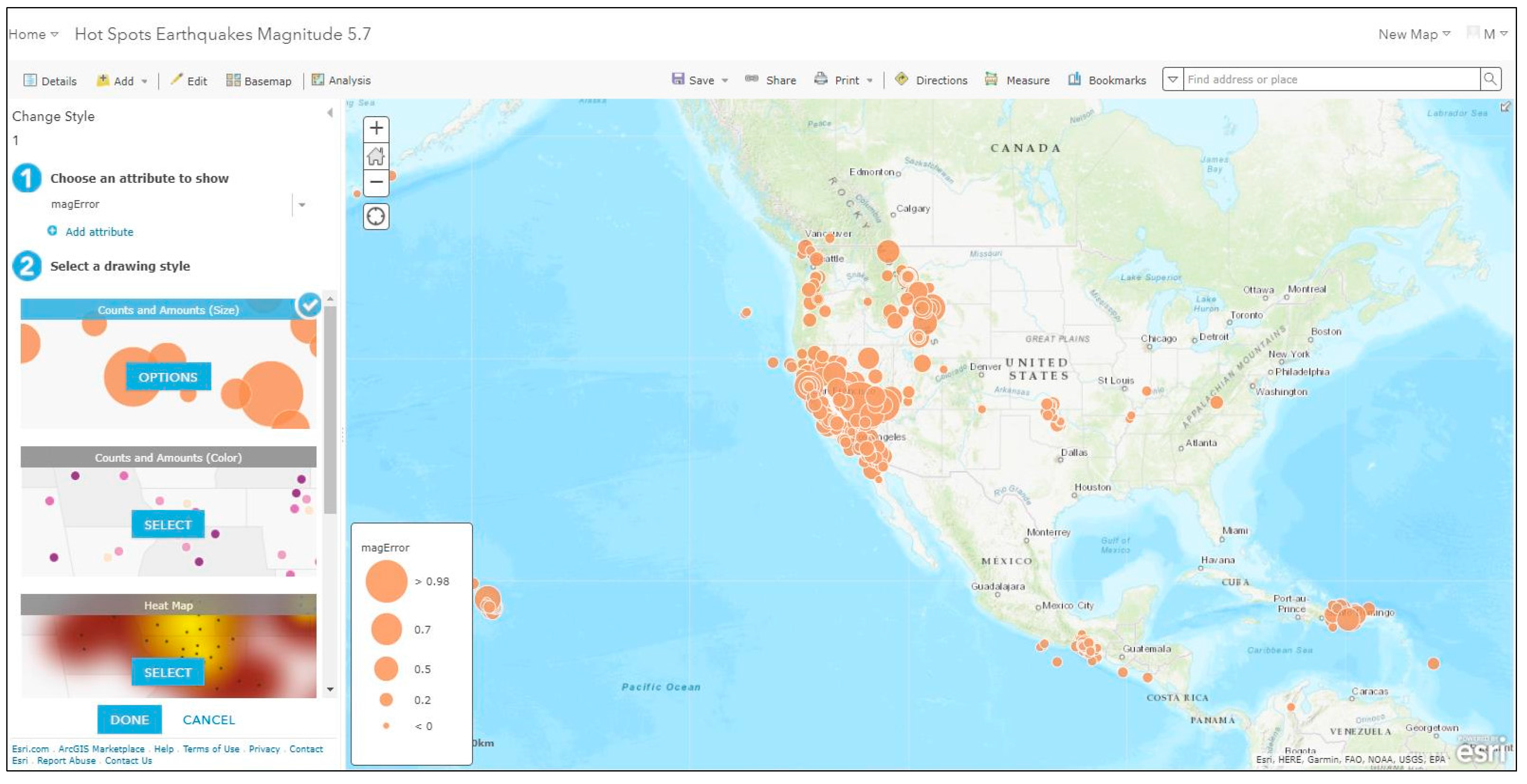
3.2. Using Space and Place to Analyse Regional and Local Variations in Tsunami Impacts (Type 2 Powerful Knowledge)

Figure 8 shows a hotspot map constructed to analyse spatial variations in tsunami impacts. Students could use the map to ask further geographical questions (Step 1 in the Steps in the GIS Enquiry Process) about:
  • The east-west spread of the tsunamis radiating from the north-south tectonic fault
  • Variations in arrival times (e.g., 15 min Sumatra/7 h Somalia)
  • The role of distance (e.g., nearby Bangladesh experienced fewer casualties/distant Somalia more casualties)
  • Unexpected high impacts in distant places (e.g., Kerala, Indiadespite an intervening landmass, Sri Lanka west coast via headland wave defraction)
  • Tsunami lag time in Thailand despite proximity, as waves slowed down in the shallowerAndaman sea
Impacts on the region as a whole as communities surprised by waves due to no tsunami warning systems [42].
The map contains a range of data from which students can acquire and explore the information to answer questions on each of the spatial variations described above (Steps 2 and 3 in the Steps in the GIS Enquiry Process).

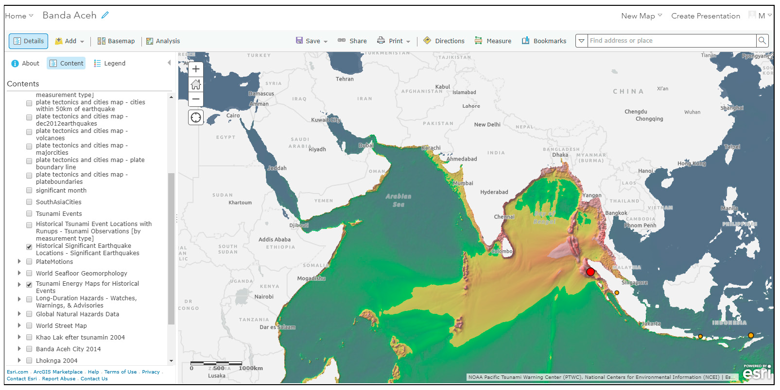
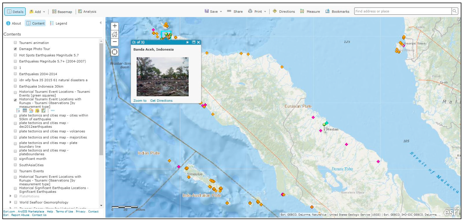
3.3. Using Place to Analyse Variations in Tsunami Impacts at a Local Scale (Type 2 Powerful Knowledge)

Places can be considered as natural foci for the study of complex relationships between geographical processes and phenomena [43]. Figure 9 shows a web map to analyse impacts of the tsunami at a local scale. Students could use tsunami run up, arrival, height, impact data, aerial imagery and photographs of specific locations to connect specific geographical variables with the extent of tsunami impacts.
For example in studying impacts in Aceh, Indonesia, students could use this map to ask questions of the data (Step 1 in GIS Enquiry) about:
  • the contrasting inundation of tsunami on the west (less affected) side of the Banda Aceh coast as opposed to the east sea side (more affected)
  • Coastal villages on the low-lying islands of Weh, Breuh and Nasi just north of the mainland that were completely destroyed
  • Lhoknga, the first major town to be hit by tsunami which received waves as high as 30 metres and was totally destroyed
  • Meulobah, where the inland inundation reached over 5 kilometres [44]

3.4. Using Place, Space and Interconnection to Make Generalisations (Types 2, 3 and 5 Powerful Knowledge)

As the discussion has shown, new webGIS is well-suited to creating geography curriculum artefacts. In the example, a GIS enquiry approach, the webGIS maps and the tools contained within it can be used in conjunction with geography’s meta-concepts of place, space and interconnection to explain and analyse a range of key physical and human elements of the 2004 Indian Ocean Tsunami (Type 2 knowledge). The complexities of nexus events such as these also lend themselves to creative teachers adopting enquiry approaches involving student’s specific use of a range of geographical concepts, ideas and themes within the event to generalise about the patterns identified (Type 2 knowledge). Students can access a range of information about human and physical factors involved and decide for themselves which variables to explore, map and analyse further (Type 3 knowledge).

4. Conclusions

WebGIS tools are of considerable significance for geography education not only in terms of their educative application for mapping, analysing and explaining geographical patterns. The removal of most of the historical barriers to GIS use in schools regarding cost, complexity and access has been a real watershed for those teachers now incorporating the use of webGIS in their classrooms. New developments in smart mapping, open source data and mobile applications are paving the way for a re-energised use of geospatial information in geography particularly through well-established enquiry-based learning approaches.
However, this paper has argued that the successful implementation of these kinds of innovations is only really part of the story in ensuring that webGIS tools achieve their full potential for young people’s geographical education.
The paper has made a case for a future use of webGIS tools to enhance geography education that embraces not only the technological innovations associated with webGIS but also the creation of powerful disciplinary knowledge (PDK) through a subject-led Geocapabilities approach.
Through the presentation and analysis of a webGIS geography curriculum artefact, the paper has demonstrated how teachers, leading with their expert subject knowledge, could use webGIS tools and applications to engage students in geographical thinking that is fundamentally underpinned by the subject’s key concepts.
This paper has stressed the central role of specialist geography knowledge in teacher’s work as curriculum makers. A GeoCapabilities approach to using webGIS implies a change in approach for teacher educators training new and continuing teachers to use GIS. Whereas before training often used to focus on teachers acquiring GIS competences, a move to a subject-knowledge led approach to training would need to incorporate developing their GIS skills in tandem with their abilities to apply Geocapabilities principles to geography curriculum making.
The use of geospatial information in school geography has entered a new era, one in which the promise of high quality mapping, spatial analysis and geovisualisation to support geographical learning via webGIS is more accessible than ever before. As Doreen Massey articulated in ‘Taking on the World’, meaningful learning about the planet’s many pressing issues such as climate change, geopolitical shifts and patterns of economic uncertainty have never been so marked [45]. For young people this should require careful consideration of the significance of geographical context and the specificity and the interconnectedness of place(s) through the kinds of digital learning environments that are now on offer. This paper has argued that moving towards a GeoCapabilities approach could lead the way for including the use of webGIS as a key tool in enabling this kind of 21st century geography education in schools.

Author Contributions

Mary Fargher is the sole author.

Conflicts of Interest

The author declares no conflicts of interest.

References

  1. Lambert, D. Curriculum Thinking, ‘Capabilities’ and the Place of Geographical Knowledge in Schools. J. Jpn. Educ. Res. Assoc. Soc. Stud. 2014, 81, 1–11. [Google Scholar]
  2. ESRI Smart Mapping. Available online: http://www.esri.com/software/arcgis/smart-mapping (accessed on 31 August 2017).
  3. ESRI Story Maps. Available online: https://storymaps.arcgis.com/en/ (accessed on 31 August 2017).
  4. Young, M.; Lambert, D.; Roberts, C.R.; Roberts, M.D. Knowledge and the Future School: Curriculum and Social Justice; Bloomsbury: London, UK, 2014. [Google Scholar]
  5. Biddulph, M.; Lambert, D.; Balderstone, D. Learning to Teach Geography in the Secondary School: A Companion to School Experience; Routledge: Abingdon, UK, 2015. [Google Scholar]
  6. Lambert, D.; Morgan, J. Teaching Geography 11–18: A Conceptual Approach; Open University Press: London, UK, 2010. [Google Scholar]
  7. Curriculum Artefacts. Available online: http://www.geocapabilities.org/training-materials/module-2-curriculum-making-by-teachers/into-practice/ (accessed on 31 August 2017).
  8. Maude’s Typology of Powerful Geography. Available online: http://www.geocapabilities.org/wp-content/uploads/2016/02/A-typology-of-geography%E2%80%99s-powerful-knowledge.pdf (accessed on 31 August 2017).
  9. National Research Council and Geographical Sciences Committee. Learning to Think Spatially; National Academies Press: Washington, DC, USA, 2008. [Google Scholar]
  10. Fargher, M. Using Geographic Information (GI). In Debates in Geography Education, 2nd ed.; Jones, M., Lambert, D., Eds.; Routledge: Abingdon, UK, 2017; pp. 197–210. [Google Scholar]
  11. Favier, T.T.; Van der Schee, J.A. Exploring the characteristics of an optimal design for inquiry-based geography education with Geographic Information Systems. Comput. Educ. 2012, 58, 666–677. [Google Scholar] [CrossRef]
  12. Lei, P.L.; Kao, G.Y.M.; Lin, S.S.; Sun, C.T. Impacts of geographical knowledge, spatial ability and environmental cognition on image searches supported by GIS software. Comput. Hum. Behav. 2009, 25, 1270–1279. [Google Scholar] [CrossRef]
  13. Fargher, M.; Rayner, D. United Kingdom: Realizing the potential for GIS in the school geography curriculum. In International Perspectives on Teaching and Learning with GIS in Secondary Schools; Milson, A.J., Demirci, A., Kerski, J.J., Eds.; Springer: Dordrecht, The Netherlands, 2012; pp. 299–304. [Google Scholar]
  14. ESRI Geographic Inquiry: Thinking Geographically. Available online: http://www.esri.com/Industries/k-12/education/~/media/Files/Pdfs/industries/k-12/pdfs/geoginquiry.pdf (accessed on 31 August 2017).
  15. Roberts, M. Geography through Enquiry; Geographical Association: Sheffield, UK, 2013. [Google Scholar]
  16. Kerski, J.J. The implementation and effectiveness of geographic information systems, technology and methods in secondary education. J. Geogr. 2003, 102, 128–137. [Google Scholar] [CrossRef]
  17. Fargher, M. GIS and other geospatial technologies. In Handbook of Secondary Geography; Jones, M., Ed.; Geographical Association: Sheffield, UK, 2017; pp. 244–259. [Google Scholar]
  18. Xerox Park Map Viewer. Available online: https://web.archive.org/web/20060916133035/http://www2.parc.com/istl/projects/www94/mapviewer.html (accessed on 31 August 2017).
  19. Worldwide Earthquake Locator. Available online: https://www.geos.ed.ac.uk/~quakes/v6_beta/map.html (accessed on 31 August 2017).
  20. GLOBE. Available online: https://www.globe.gov/about/history (accessed on 31 August 2017).
  21. KanCRN. Available online: http://www.pathfinderscience.net/about (accessed on 31 August 2017).
  22. Journey North. Available online: https://www.learner.org/jnorth/maps (accessed on 31 August 2017).
  23. Baker, T.R. WebGIS in Education. In Geospatial Technologies and Geography Education in a Changing World; Muñiz Solari, O., Demirci, A., van der Schee, J.A., Eds.; Springer: Dordrecht, The Netherlands, 2015; pp. 105–115. [Google Scholar]
  24. ESRI ArcGIS Online. Available online: http://www.esri.com/software/arcgis/arcgisonline (accessed on 31 August 2017).
  25. QGIS. Available online: https://www.qgis.org/en/site/ (accessed on 31 August 2017).
  26. ESRI UK Getting Started with ArcGIS Online. Available online: https://schools.esriuk.com/wp-content/uploads/Getting_started_with_ArcGIS_Online.pdf (accessed on 31 August 2017).
  27. EDINA Digimap OpenStream. Available online: https://openstream.edina.ac.uk/ (accessed on 31 August 2017).
  28. QGIS. Teaching Materials. Available online: https://mapstream.edina.ac.uk/resources/Fracking/Frackinginstructions.pdf (accessed on 31 August 2017).
  29. ESRI Survey 123 for ArcGIS. Available online: https://survey123.arcgis.com/ (accessed on 31 August 2017).
  30. ArcGIS Online in Secondary Education. Michael Gould ESRI, Thierry Torres, Antwerp International School Story Map. Available online: http://dgsb.maps.arcgis.com/apps/MapJournal/index.html?appid=820ed382cdd6442996728fa3bfae2293 (accessed on 31 August 2017).
  31. Nussbaum, M.; Sen, A. The Quality of Life; Oxford University Press: Oxford, UK, 1993. [Google Scholar]
  32. Lambert, D.; Solem, M.; Tani, S. Achieving human potential through geography education: A capabilities approach to curriculum making in schools. Ann. Assoc. Am. Geogr. 2015, 105, 723–735. [Google Scholar] [CrossRef]
  33. Young, M. Bringing Knowledge Back in London; Routledge: London, UK, 2008. [Google Scholar]
  34. Solem, M.; Lambert, D.; Tani, S. Geocapabilities: Towards an international framework for researching the purposes and values of geography education. Rev. Int. Geogr. Educ. Online 2013, 3, 204–219. [Google Scholar]
  35. Maude, A. What might Powerful Knowledge look like? Geography 2016, 101, 70–76. [Google Scholar]
  36. Young, M.; Muller, J. Three Educational Scenarios for the Future: Lessons from the Sociology of Knowledge. Eur. J. Educ. 2010, 45, 11–27. [Google Scholar] [CrossRef]
  37. Mitchell, D.; Lambert, D. Subject knowledge and teacher preparation in English secondary schools: The case of geography. Teach. Dev. 2015, 19, 365–380. [Google Scholar] [CrossRef]
  38. Lambert, B.; Biddulph, M. The dialogic space offered by curriculum-making in the process of learning to teach, and the creation of a progressive knowledge-led curriculum. Asia-Pac. J. Teach. Educ. 2015, 43, 210–224. [Google Scholar] [CrossRef]
  39. Curriculum Making. Available online: http://www.geocapabilities.org/training-materials/module-2-curriculum-making-by-teachers/theory (accessed on 31 August 2017).
  40. Curriculum Artefacts. Available online: http://geocapabilities.org.gridhosted.co.uk/wp-content/uploads/2016/02/Curriculum-Making-using-curriculum-artefacts.pdf (accessed on 31 August 2017).
  41. Maude, A. Applying the concept of powerful knowledge in school geography. In The Power of Geographical Thinking; Brooks, C., Butt, G., Fargher, M., Eds.; Springer: Cham, Switzerland, 2017; pp. 27–40. [Google Scholar]
  42. 2004 Indian Ocean Earthquake. Available online: http://www.newworldencyclopedia.org/entry/2004_Indian_Ocean_earthquake (accessed on 31 August 2017).
  43. Rediscovering Geography Committee. Rediscovering Geography: New Relevance for Science and Society; National Academy Press: Washington, DC, USA, 1997. [Google Scholar]
  44. Saatcioglu, M.; Ghobarah, A.; Nistor, I. Effects of the December 26, 2004 Sumatra earthquake and tsunami on physical infrastructure. ISET J. Earthq. Technol. 2005, 42, 79–94. [Google Scholar]
  45. Massey, D. Taking on the World. Geography 2014, 99, 36–39. [Google Scholar]
Figure 1. Mapping earthquake distributions with smart mapping tools.
Ijgi 07 00111 g001
Figure 2. Using open source data in enquiry-based learning in QGIS.
Ijgi 07 00111 g002
Figure 3. Fieldwork data collection with ESRI ArcGIS Online and Survey 123.
Ijgi 07 00111 g003
Figure 4. The curriculum making model.
Ijgi 07 00111 g004
Figure 5. The artefact base map.
Ijgi 07 00111 g005
Figure 6. Exploring the causes of the 2004 Indian Ocean earthquake.
Ijgi 07 00111 g006
Figure 7. Exploring the shape of the ocean floor.
Ijgi 07 00111 g007
Figure 8. Exploring tsunami hotspots.
Ijgi 07 00111 g008
Figure 9. Aceh, Indonesia.
Ijgi 07 00111 g009
Table 1. Steps in Enquiry in GIS (After ESRI 2003).
StepWhat to DoType of Knowledge Construction
Ask a geographical questionAsk questions about the world around youEnquiry
Acquire geographical dataIdentify data and information that you need to answer your questionsInventory
Explore geographical dataTurn the data into maps, tables, graphs and look for patterns and relationshipsSpatial processing and analysis
Analyse geographical informationTest a hypothesis, carry out map, statistical, written analysis using evidenceSpatial Analysis, Modelling, Decision Making
Table 2. A typology of geography’s powerful knowledge.
TypeCharacteristic
1.
Knowledge that provides students with ‘new ways of thinking about the world.’
Using ‘big ideas’ such as: • Place • Space • Environment • Interconnection
These are meta-concepts that are distinguished from substantive concepts, like ‘city’ or ‘climate’.
2.
Knowledge that provides students with powerful ways of analysing, explaining and understanding.
Using ideas to:
  • Analyse e.g., place; spatial distribution
  • Explain e.g., hierarchy; agglomeration
  • Generalise e.g., models (push-pull models of migration; demographic transition)
3.
Knowledge that gives students some power over their own knowledge.
To do this, students need to know something about the ways knowledge has been, and continues to be developed and tested in the discipline. This is about having an answer to the question: ‘how do you know?’ This is an underdeveloped area of geographical education, but is a crucial aspect of ‘epistemic quality’ (Hudson, 2016).
4.
Knowledge that enables young people to follow and participate in debates on significant local, national and global issues.
School geography has a good record in teaching this knowledge, partly because it combines the natural and social sciences, and the humanities. It also examines significant ‘nexus’ issues such as: food, water and energy security; climate change; development.
5.
Knowledge of the World
This takes students beyond their own experience—the world’s diversity of environments, cultures societies and economies. In a sense, this knowledge is closest to how geography is perceived in the popular imagination. It contributes strongly to a student’s ‘general knowledge’.
Table 3. Constructing powerful geography knowledge with WebGIS.
Powerful Geography KnowledgePedagogy
1.
Knowledge that provides students with ‘new ways of thinking about the world.’
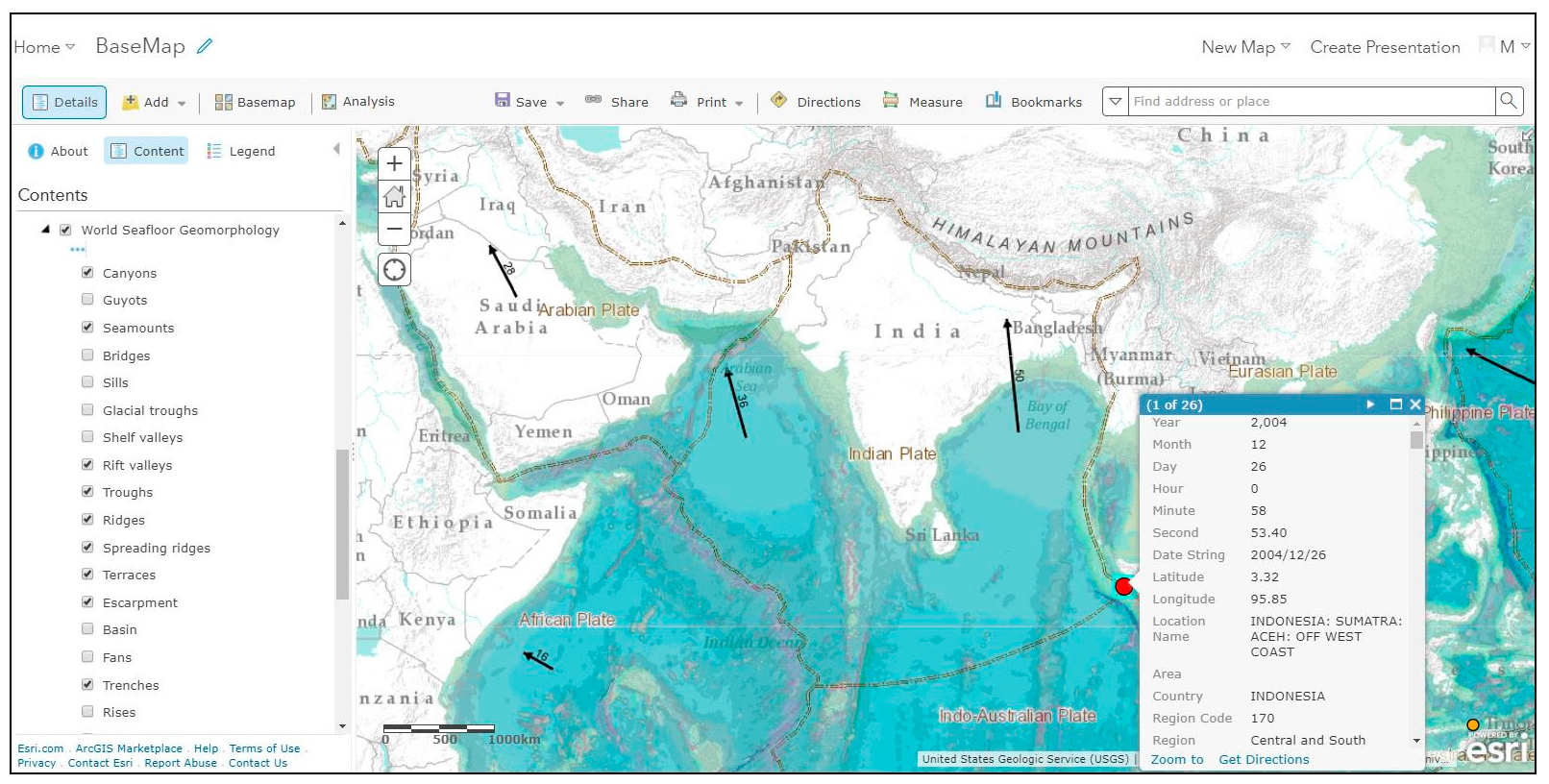
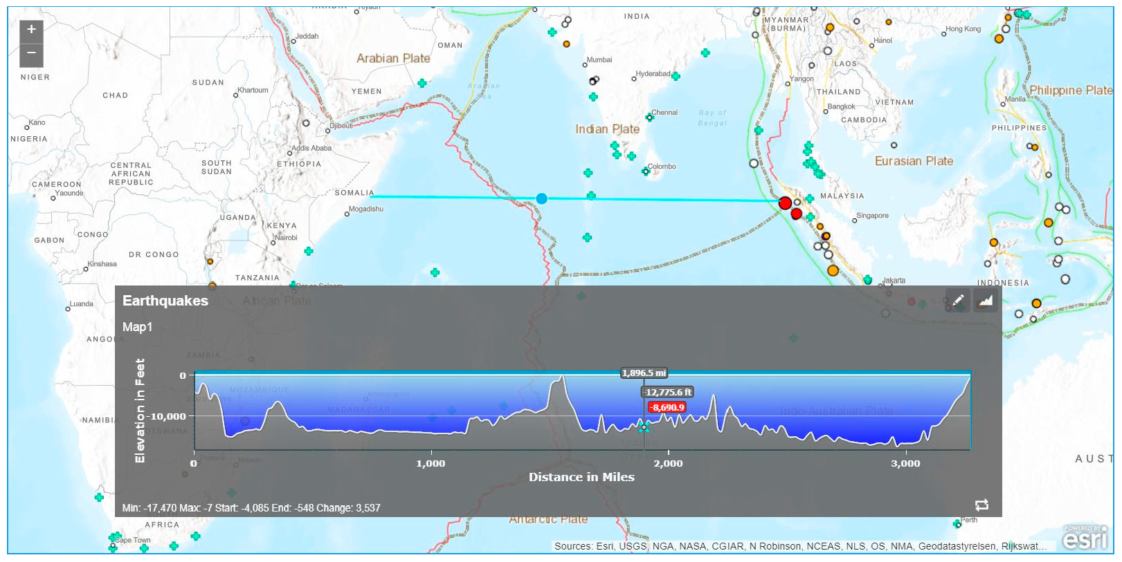
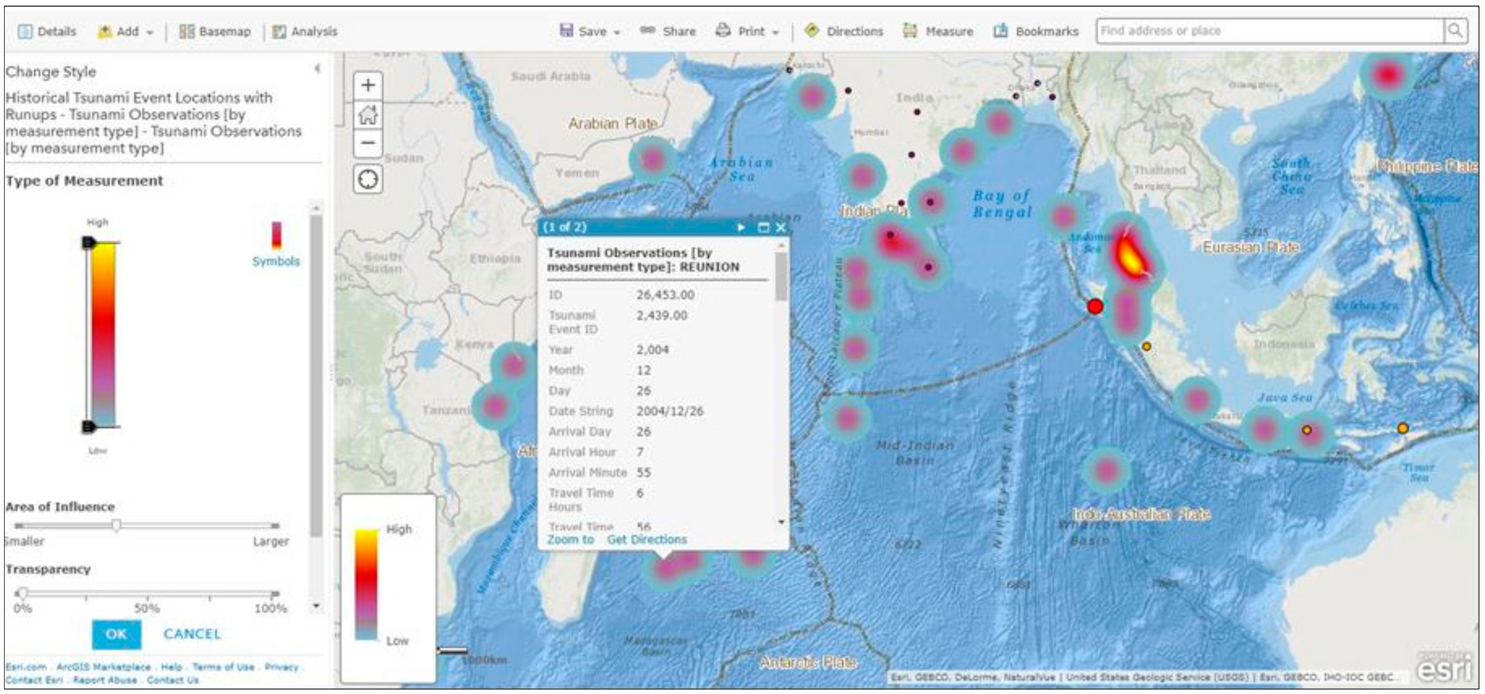
Using geography’s concepts of place, space and interconnection to unravel the complexity of the earthquake–tsunami
(Figure 5 The artefactbase map)
2.
Knowledge that provides students with powerful ways of analysing, explaining and understanding.
Using interconnection to explain causes and effects
(Figure 6 Exploring the causes and effects of the Indian Ocean tsunami)
Using place to compare landforms
(Figure 7 Exploring the shape of the ocean floor)
Using space and place to explore regional and local variations in tsunami impacts
(Figure 8 Exploring tsunami hotspots)
Using place to study tsunami impact variations at local places
(Figure 9 Aceh, Indonesia)
Using interconnection, place and space to synthesise knowledge and make generalisations
(Figure 5, Figure 6, Figure 7, Figure 8 and Figure 9)
3.
Knowledge that gives students some power over their own knowledge.
Identifying, mapping and analysing tsunami hotspots
(Figure 5, Figure 6, Figure 7, Figure 8 and Figure 9)
4.
Knowledge that enables young people to follow and participate in debates on significant local, national and global issues.
Examining the earthquake/tsunami and its causes and local and regional impacts as a nexus event
(Figure 5, Figure 6, Figure 7, Figure 8 and Figure 9)
5.
Knowledge of the World
Knowledge that takes students to places beyond their own experience by thinking with concepts of interconnection, place and space
(Figure 5, Figure 6, Figure 7, Figure 8 and Figure 9)

