1. Introduction
Site selection is one of the basic decisions in a public urban space that can be determined based on topographic interest, land availability, land use, and public preference [
1]. The site needs to be free of any natural or environmental interference, undesirable industry, business, or traffic hazards, and it needs be accessible to present and future populations. In most communities, however, the most favorable site is elusive to find [
2,
3]. Traditionally, site selection relied on an expert’s knowledge, while the main users of the facilities, such as urban managers and especially public citizens, were not included [
4]. Thus, the locations of selected areas do not meet user’s interests and requirements [
5]. One of the most important urban facilities is public parking. Today, due to the widespread use of the automotive, almost all large cities experience public parking unavailability. In fact, one of the issues that comes up to solve the traffic problem is the right choice for public parking [
6,
7]. Therefore, it is necessary to study a previous approach to obtain the most advantageous site selection for public parking.
Site selection for urban facilities has been studied for many years. The American Institute of Transportation Engineers gave a summary of different cities in some countries in the USA Continent, the UK and Asia. They found that the accessory parking ratio was proportional to the urban transportation system and car ownership rate [
8]. The study by Boroushaki and Malczewski (2010) described Web-Based Collaborative Spatial Decision making and Participatory GIS as a proof of concept. They discussed the potential of the Internet to facilitate collaborative, spatial decision making. Moreover, they considered the fuzzy majority method using Induced Ordered Weighted Averaging (IOWA) for spatial group decision-making. As a result, these multi-criteria decision analysis (MCDA) methods provide a mechanism for bridging the gap between public residents and experts. However, the technological limitations in developing countries can be found [
9]. Parker et al. (2013) integrated Volunteer Geographic Information (VGI) and Participatory GIS (PGI) in an outdoor recreation context. They demonstrated that both VGI and PGI have a greater ability to influence the user in the planning phase than during the activity [
10].
Li et al. (2014) studied the users’ actions, which was modeled based on a new type of Spatial-aware Interest Group query that retrieves a user group, where each user is interested in the query keywords and they are close to each other in Euclidean space [
11]. Malczewski and Rinner (2015) investigated a collaborative multivariable decision analysis for students who are practitioners in different fields of GIScience [
12]. Hong (2015) analyzed the spatial patterns of Location-Based Social Network (LBSN) data in Seoul using spatial analysis techniques of a geographic information system. The data were compiled with a schema that was produced based on Foursquare’s Python API. Based on the analytical results, the researcher were able to identify venue clusters around city centers, as well as differences in hotspots for various venue categories and correlations with census variables [
13].
Levy et al. (2015) presented ParkFit, which is defined as a spatially-explicit high-resolution view of urban parking supply and demand. As a practical setting, ParkFit has its own limitations. For example, one must establish the maximal acceptable distance for parking, which could be far away from one’s destination. Second, this model cannot incorporate parking search times, price, and turn over, local factors of driver’s favorable spot, security, and road crossings during the walk [
14]. The Abbasi et al. (2017) study investigated the potential of LBSN data alongside the rank concept in predicting human mobility patterns in Manhattan, New York City. They suggest three scenarios, including rank-distance, the number of venues between origin and destination, and a check-in weighted inception schema. In this study, applying a check-in weighting schema to trip distribution patterns resulted in a sample that was little approximately more similar to the ground truth data. As the predicted numbers of trips were closer to the real number of trips, trip distribution was also increased by about 50% [
15].
Recently, Krieg et al. (2018) presented Smart Park, a system for real-time parking information relying on smartphone sensors and a ubiquitous Wi-Fi/cellular infrastructure. Experimental results from 12 volunteers revealed that Smart Park identified unparking events 97% of the time, while triggering zero false positives. While Smart Park uses simulations to minimize the initial deployment cost and risk, it fails to detect unparking events when the distance between two cars is 10 m or less [
16]. Here, we demonstrate the incorporation of multi decision makers based on geo-social network to optimize an urban public site selection in Tehran, which is the most populated city in Iran.
As a practical setting for model development, we assess the problem of selecting sites for public parking.
Section 2 presents the Analytic Hierarchy Process as a GIS-based multi-criteria decision analysis (MCDA). Then, the related concepts and the detailed analysis are demonstrated in
Section 3. Finally, conclusions and directions of potential future research are considered in
Section 4.
2. Materials and Methods
Our design consists of three parts. In the first part, we use AHP to plan site selection using multi-criteria decision making analysis. Then, we consider the geo-social network as a platform for handling different views. Finally, the proposed model and its characteristics are illustrated.
2.1. Site Selection and Multi-Criteria Decision Analysis
Formerly, site selection was based entirely on economic and technical criteria. Selection criteria must also please social and environmental requirements, which are enforced by legislation and government regulations. Nowadays, in the post-industrial and knowledge-based society, people become the most important resource. The process of site selection needs complex multi-criteria analyses, which include an array of factors involving economic, social, technical, environmental, and political issues that may result in conflicting objectives [
17]. GIS-based multi-criteria decision analysis (MCDA) is a set of techniques for solving spatial problems by considering and weighting different criteria (i.e., geographical features) in the decision making process [
3,
18].
The MCDA issue ordered support including multi-objective decision analysis (MODA) for multi-attribute decision making (MADA), individual for group decision-maker, and decision under confidence for decision under confidence. Decision making is relying on spatial data, information and communication technologies. It is used by managers and decision-makers to exchange opinions and information, which is a requisite when focusing on specific decision topics. Spatial decisions considered on the basis of multiple criteria [
3].
2.2. Geo-Social Networks
The worldwide progress in universal relations, computer networks, and location-based services has introduced a novel trend in Geographic information system. Geo-social networks as integrating systems of mobile devices, wireless networks, and other GIS capabilities have developed in the geographic information system scope [
19,
20]. In fact, technological progress has led to an increasing expansion of data sources. Since the innovation of social networks, numerous studies about users’ activities have been executed.
The dimension of place helps link the gap between the physical world and virtual social networking services [
21]. On the other hand, public participation activities utilized from geo-social networks capabilities are used to solve urban spatial problems [
11,
22].
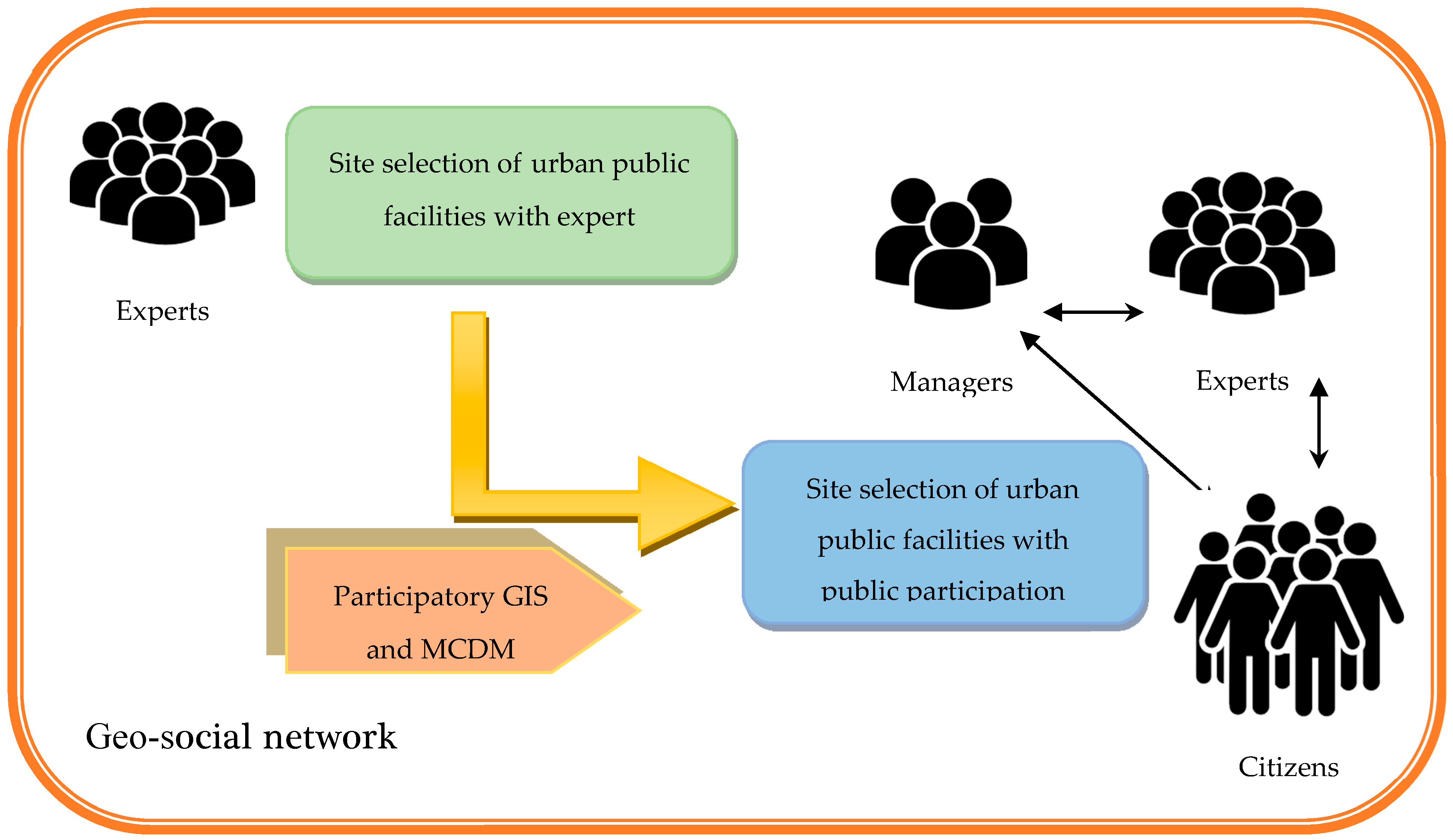
In addition, it is an appropriate platform for collaboration among public citizens, urban experts, and governmental managers. However, this collaboration was not mentioned for site selection of public facilities until now. Users are always in their area of residence and activity and they use suitable site to structure the environment and to support urban services [
23].
2.3. Proposed Method
This paper tries to solve the urban site selection problem using participatory GIS through geo-social networks. In this way, the proposed methodology is designed as shown in
Figure 1.
A Geographic Information System (GIS) is a basic part of modelling technology for urban data management and analysis. Therefore, integration of GIS with other methods makes it possible to model most of the MCDM approach [
24].
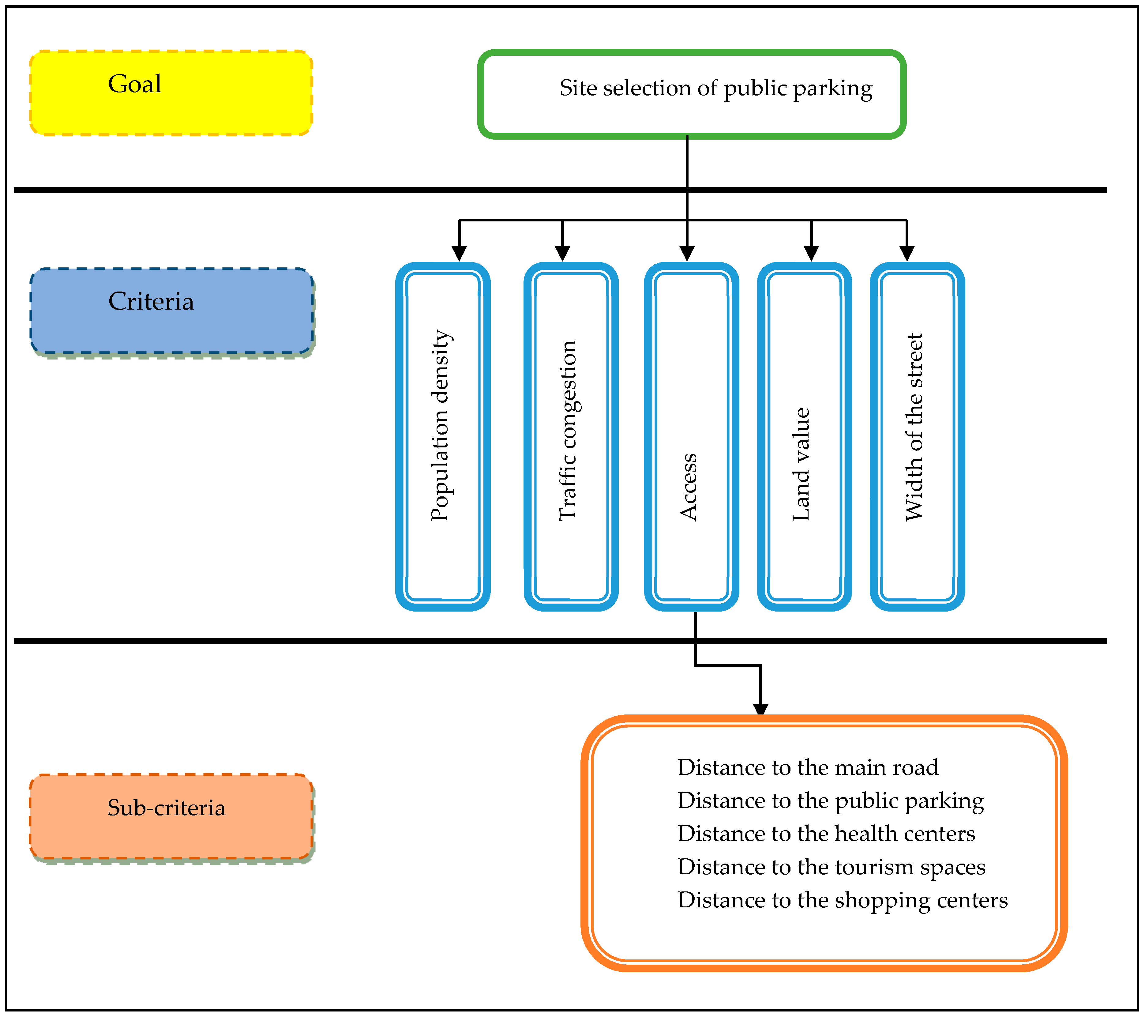
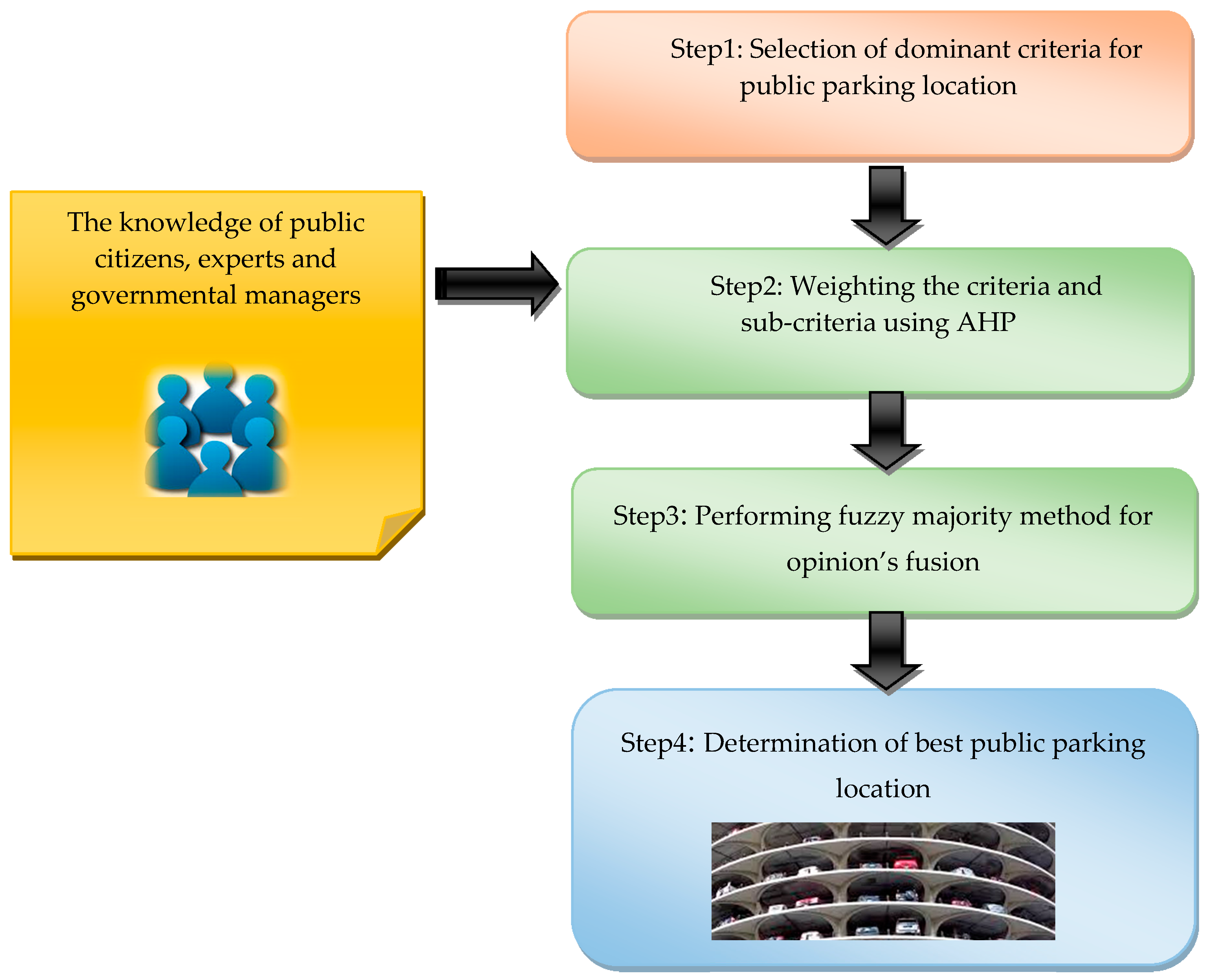
Step#1: This step is concentrated on the selection of dominant criteria, which have an effect on the determination of appropriate public parking in an urban area. To achieve this, we selected five criteria: Population density, traffic congestion, access, land value, and width of street. Among these criteria, “access” has sub-criteria, as illustrated in
Figure 2.
Step#2: Weighting of the defined criteria is an important stage and the reliability of its consequences could guarantee the final results. The weighting of the criteria is done by AHP. The AHP method is based on paired weighting. The geometric mean method was used to calculate the weight of the factors. The next step in this process is to estimate the incompatibility ratio. This probability value represents the probability of corresponding random degrees, so that values of less than 0.1 are good, values that are worth more than 0.1 are incompatible, and the weighting of the criteria should be re-established [
18,
24]. With the use of the AHP method in this study, the hierarchy of criteria for locating public parking was in accordance with
Figure 3.
Step#3: In order to aggregate the opinions of the different levels of decision-makers, the fuzzy majority approach is applied. The fuzzy majority is an aggregation procedure that through preference incorporates the opinion of the majority of decision-makers. The ultimate aggregated amount characterizes the value of the majority of the most similar amounts. The similarities between pairs of preference values can be computed using a support function,
Sup (
a,
b), which can be denoted as the support for ‘
a’ from ‘
b’ where [
25]:
Therefore, the closer two argument values are, the more that they support each other [
26]. In addition, the most supported values have more weight in the aggregation method. They demonstrated that the fuzzy majority procedure produces the majority semantic of preferences in a group decision-making process [
25].
The score of using OWA achieved for each proposed option that defined as Pk (k is decision-makers no). The problem can be defined as , which denotes the aggregation of the set preferences in such a way that the final score corresponds to the majority of the preferences values. This problem can be solved by considering all of the k values. The following steps are:
Calculating the total value support for the
kth decision-maker’s preference from other decision-makers on the
ith alternative is as follows:
The
is a binary support operation as:
Here, weight Pk is calculated using OWA (or other forms of decision). ‘α’ is a threshold in the support function.
According to the support function,
, two values support each other if the proximity or distance between the two values is less than ‘α’; otherwise, they provide no support. In this setting, ‘α’ defines the threshold by which the proximity of the values is considered supportive (close enough) or not (). By summing these values up in each row, the number
t’
k the second stage of this sort in ascending order numbers t’
k and t’
1 ≤ t’
2 ≤ … ≤ t’
q is named. Define ‘Q most’ is as fuzzy membership function that is calculated according to the following steps:
After calculating the value of ‘Q’,
Vk is achieved according to Equation (8) by dividing each value of ‘Q’ by the total column values ‘Q’:
Calculating the OWA score for each
ith location,
Ai, corresponding to the majority of the decision-makers’ preferences as follows:
where
t-index (
k) is the
kth ‘smallest’.
Step#4: After the aggregation process, the final appropriate locations are determined and evaluated.
3. Results
This section explains the implementation process. First, the case study area is introduced and the required data are illustrated. Second, the system architecture is explained. Finally, the results of the implementation are discussed.
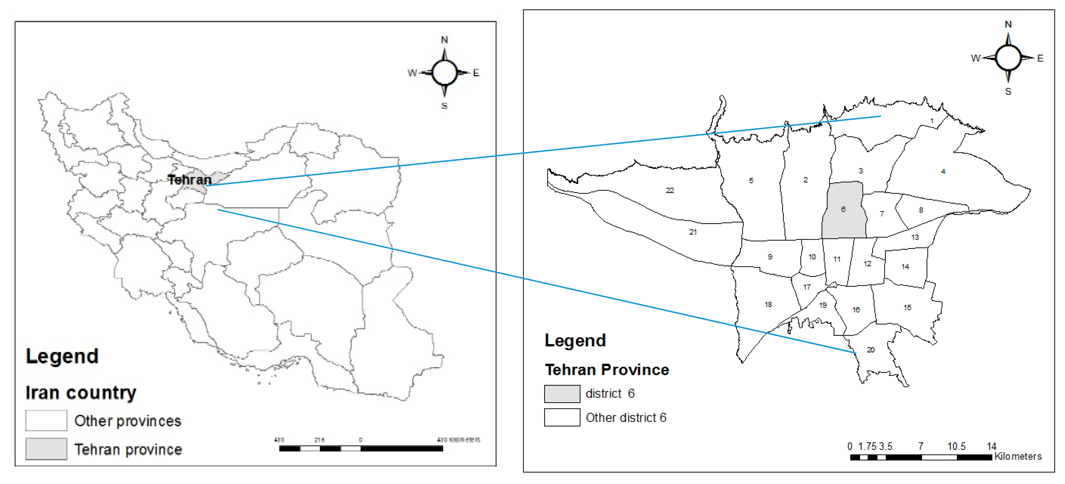
3.1. Study Area
Tehran district 6 Municipality has an area of 2138.5 hectares and comprises 3.3% of Tehran’s metropolis. In the north of this area is District 3 (Hemmat Expressway), to the east is District 7 (Modares Expressway), to the west is District 2 (Chamran Expressway), and to the south are Districts 10, 11, 12, and (Enghelab Av), which includes six regions and 18 local areas.
Figure 4 shows the geographical position of the study area. According to the latest statistics obtained, the population of District 6 is about 237,292 people, of which 119,421 are men and 117,871 are women [
27].
3.2. Required Data
As described in
Section 3, the main criteria include population density, traffic congestion, land value, width of the street, and access (which consists of distance from public parking, tourist centers, main roads, heath centers, and shopping centers). The first step in implementation is the preparation of required data, as described in
Table 1.
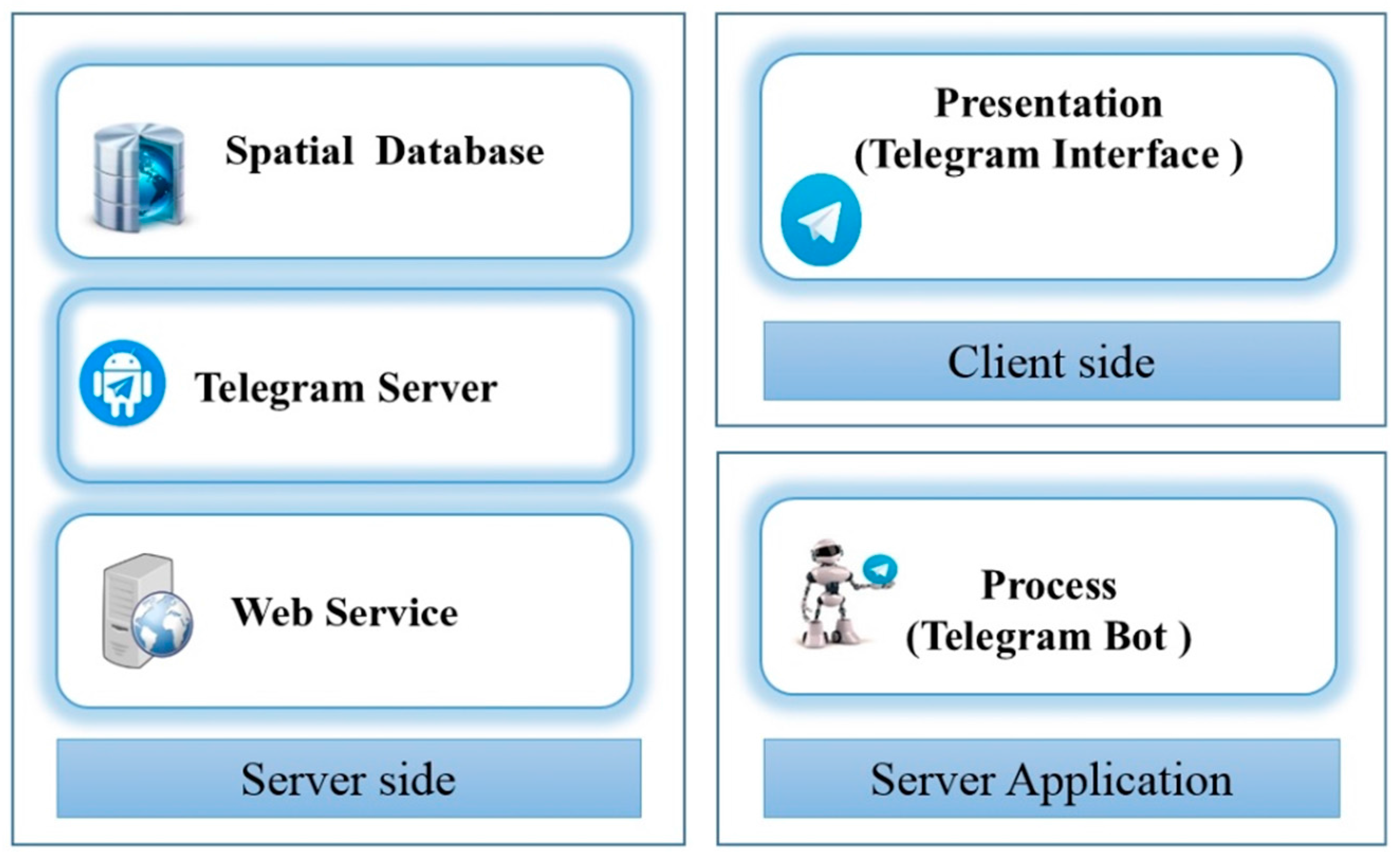
3.3. System Architecture
In this research, the telegram social network was used as a platform for decision making in the spatial group. Telegram is user-friendly and open source software that has a high security level. The architecture of the proposed system is generally designed in three physical layers, as shown in
Figure 5.
The client side is the telegram application interface. This layer reads the data in the database according to the user’s requests, and displays the appropriate map in the web browser. It was designed in the Visual Studio 2015 (C #) programming environment.
The Server Application layer is an intermediate layer and it is the data processing task. This layer verifies the data entered in each step and then prepares them for executing the algorithm and generating messages sent to the user. In this layer, the Telegram application API is used to implement the robot. The server-side layer is the data layer. This layer stores and managed data. It consists of three sets: Web service that designed with PHP 5.2.0 programming language, Server Telegram and spatial database software that designed with PostgreSQL and PostGIS software.
3.4. Graphical User Interface
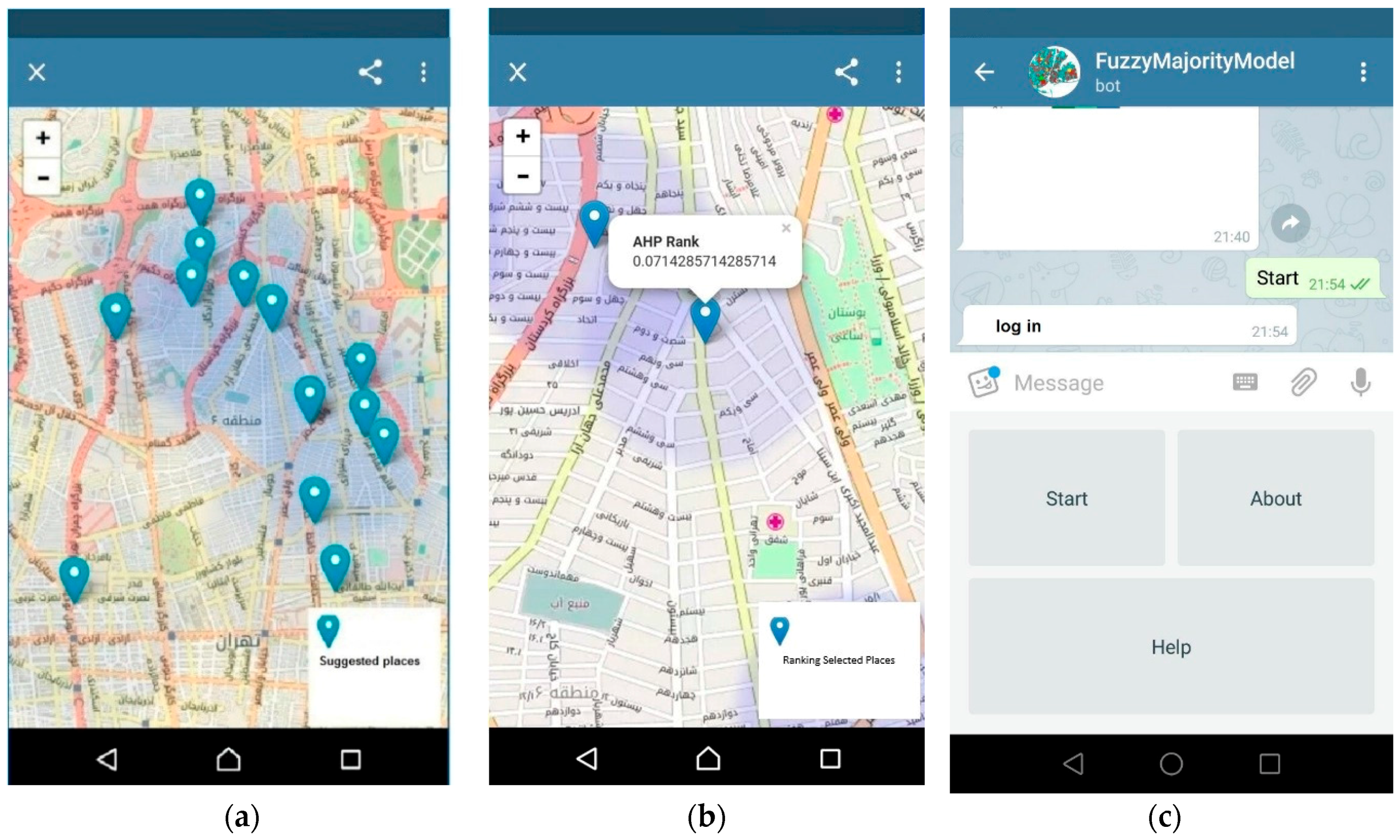
This study intends to design and implement a conceptual framework for collaborative web-based GIS for integration of different aspects of public facilities users. The PGIS framework integrated two components, including individual decision and group decision. Because the system is implemented in a social network environment, certainly, many users do not have enough knowledge and expertise in the field of geographic information systems. Therefore, a quite simple interface was designed.
The first part of the system is related to individual decision making. The user clicks on the bot name, @FuzzyMajorityModel. The user chooses the start option to communicate with the robot. In the next step, the user must enter personal information to log on to the individual decision. Then, user should select a fixed option scenario. A fixed option in the scenario is the number of places offered in the study area, and will be displayed in the form of a web-based map to the user.
The user must choose between these options at least two items and then send options to the system (
Figure 6a). Next, the two main criteria and sub-criteria matrix containing them for weighting and binary comparison is shown. After the weighting, AHP operations are carried out on the performance of the system, and the survey takes place. The final output will be displayed in a web map.
Figure 6b shows a sample of the output of an individual decision. The second part of the system is the decision making group. By entering a username and password the main expert can be logged in (
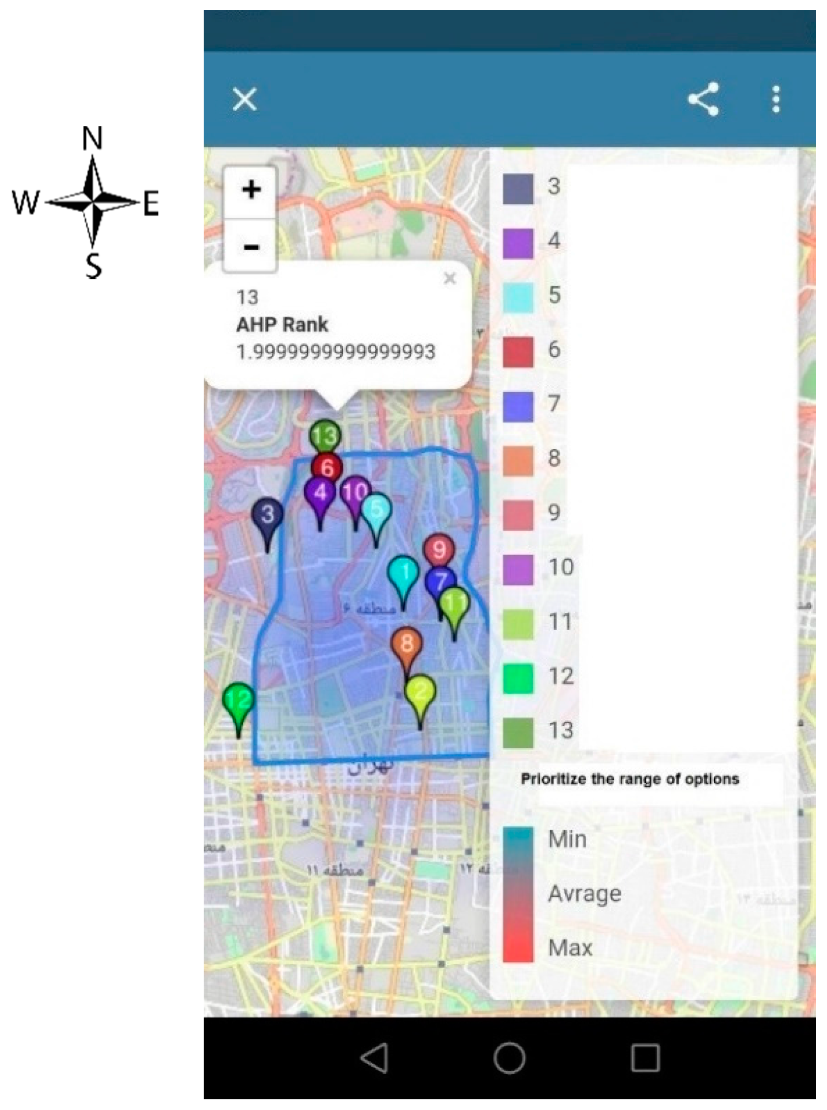
Figure 6c).
Figure 7 is an example of the output at this stage. Clicking on any point allows place priority value to be determined.
The evaluation process is completed in two stages; the system is first run only by 50 experts and then by three different levels of users, including 50 experts, 25 urban managers, and 150 pubic citizens, for the case study area via Telegram robot. Then, the archived results in both cases are compared with each other by 50 experts, 25 urban managers, and 150 pubic citizens. The selected locations for public parking are introduced to these test groups to ask their opinions according to tree evaluation factors including: “satisfaction”, “distribution of public parking”, and “suitability and ease-for-use”.
The first part of the system shows the individual decision each of experts’ and citizens’ opinions of site selection for public parking; the second part is the collaborative decision making. Clearly, scenario#2 is more applicable and appropriate for the site selection of public parking in the study area (
Table 2).
4. Conclusions and Future Works
The model presented herein is intended to facilitate site selection for public parking using a new approach of collaboration of multi-criteria decision-makers. Our setting is based on geo-social networks, due to the ease of access, user friendliness, and availability of spatial capabilities. The proposed method applied the analytic hierarchy process for weighting the criteria that was completed in two stages, once by 50 experts, and then by three different levels of users, including 50 experts, 25 urban managers, and 150 pubic citizens of the case study area. Then, the fuzzy majority method aggregated the archived results of AHP to determine the preferred locations that are suitable for public parking. The proposed method was implemented via Telegram robot. The evaluation of the proposed method is performed based on comparison of tow modes. The results justified two main advantages of the collaborative decision making scenario for solving public urban site selection: the fair distribution of the selected locations and the high satisfaction of the users.
This research has three main advantages: (1) the proposed framework is independent of application and it is performable for all public urban site selection. It is sufficient to introduce effective criteria to solve location problems; (2) the designed architecture and the implemented GUI via Telegram robot are free and accessible for every individual; and, (3) the uncertainty that stems from different opinions is modeled by fuzzy majority aggregation.
The results show that the user satisfaction of the citizens rose from 65% to 85%, this is a meaningful reason to replace the proposed approach with the traditional method. Thus, our novel model may serve as a starting point for establishing a user-friendly tool for site selection of public parking. To generalize the proposed method, we suggest examining this setting in different geographic regions and other urban public site selection problems, such as shopping centers, heath care centers, and gas stations. A limitation of the model is that it implemented in the public space of an urban district, which is not familiar with spatial criteria. Effectively, this may decrease the accuracy of choices. Clearly, we recommend further investigation to develop an optimal model of site selection for urban facilities using geo-social networks.


