

Analysis of Formation Mechanism of Slightly Inclined Bedding Mudstone Landslide in Coal Mining Subsidence Area Based on Finite–Discrete Element Method
(This article belongs to the Section Engineering Mathematics)
Abstract
:1. Introduction
2. Regional Geological Environment Background
3. Materials and Methods
3.1. Laboratory Geotechnical Test
3.2. Numerical Simulation
3.2.1. Discrete Element Numerical Simulation Method
- (1)
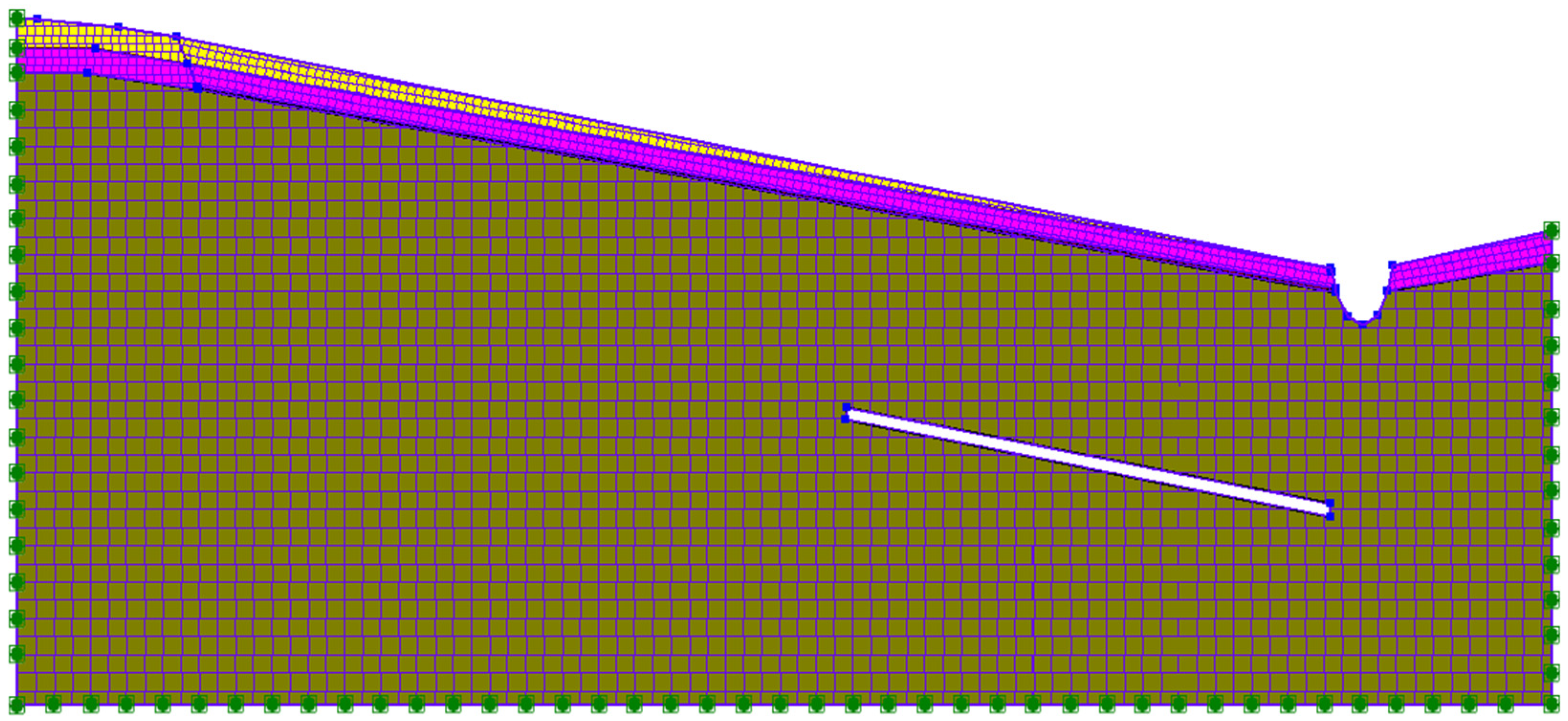
- Model establishment
- (2)
- Constitutive model
- (3)
- Parameter selection
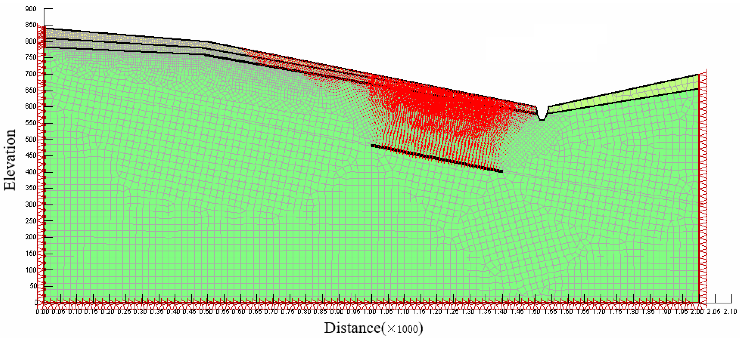
3.2.2. Finite Element Numerical Simulation Method
- (1)
- Model establishment
- (2)
- Parameter selection
3.3. Landslide Stability Analysis
3.3.1. Overview of Landslide Stability Analysis Method
3.3.2. Limit Equilibrium Method and Finite Element Limit Equilibrium Method Based on GeoStudio
- (1)
- Model establishment
- (2)
- Parameter selection
4. Results
4.1. Landslide Type and Deformation Failure Characteristics
4.1.1. Landslide Type and Morphological Characteristics
4.1.2. Deformation and Failure Characteristics of the Landslide
4.2. Numerical Simulation Results
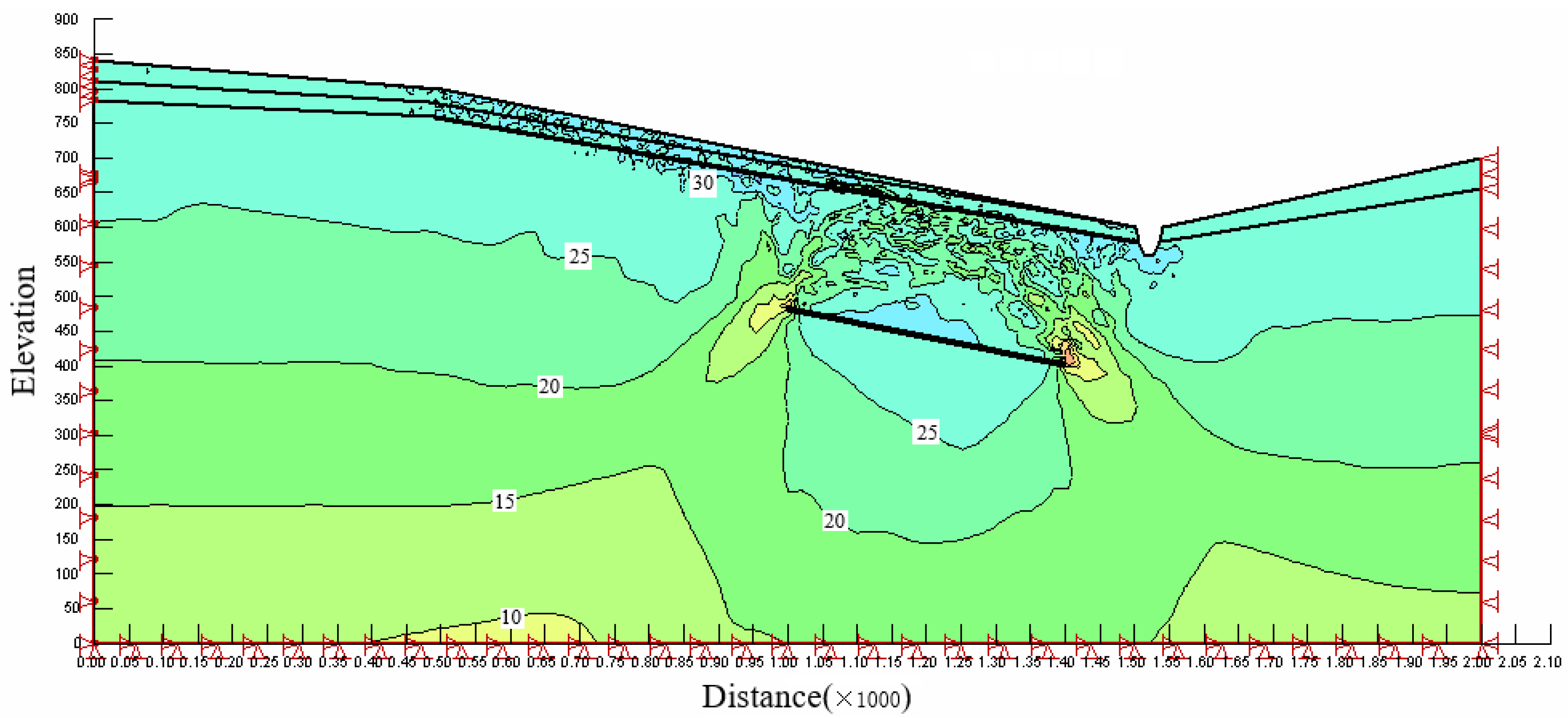
4.2.1. Numerical Simulation Results of Discrete Element Method
- (1)
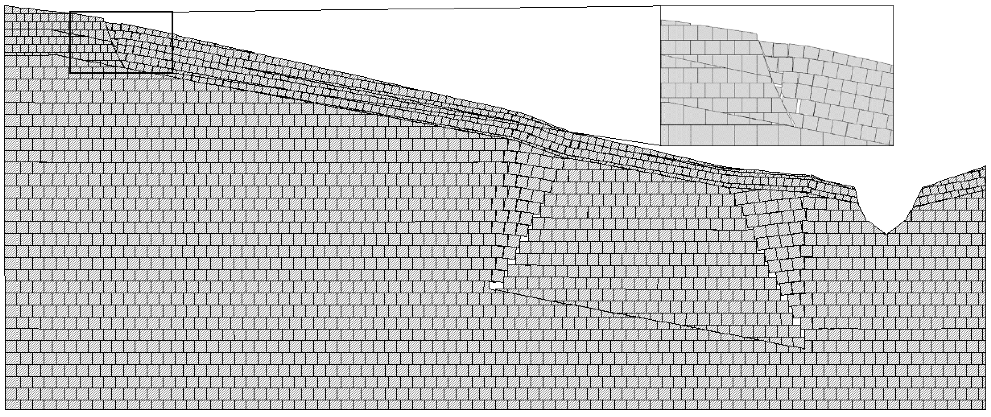
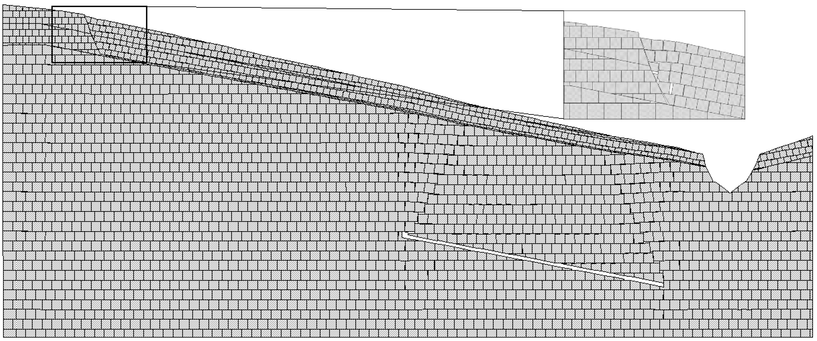
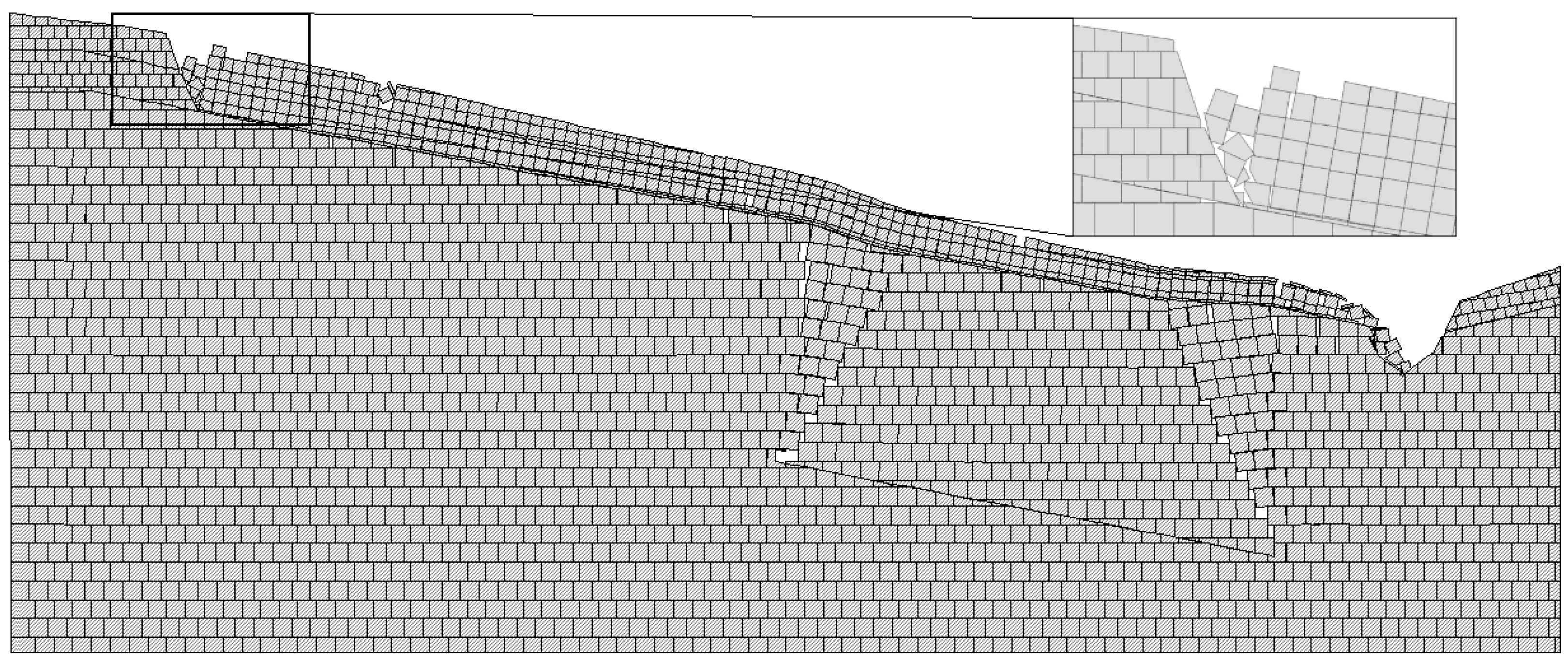
- Numerical simulation results only considering the coal mining subsidence area
- (2)
- Numerical simulation results of landslide process
4.2.2. Finite Element Numerical Simulation Results
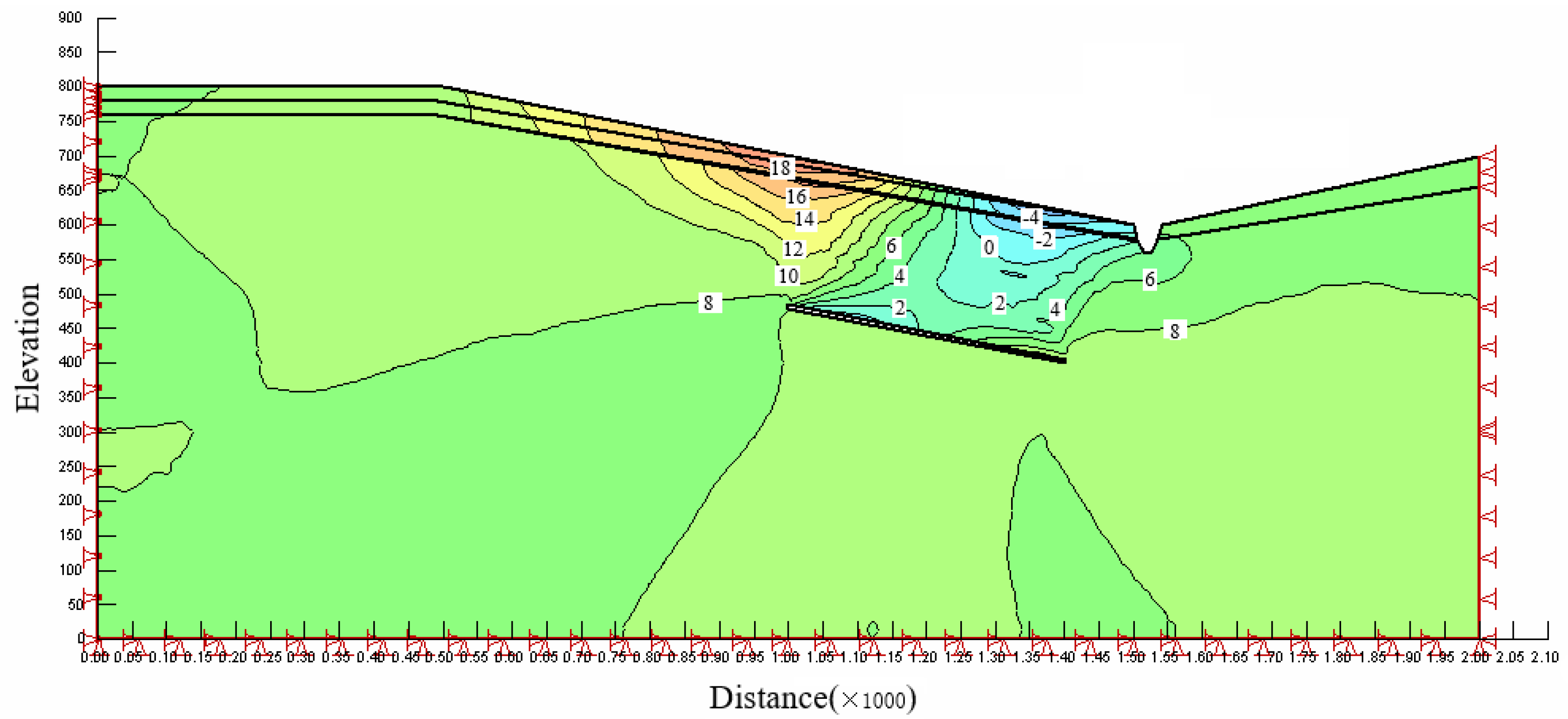
- (1)
- Displacement analysis
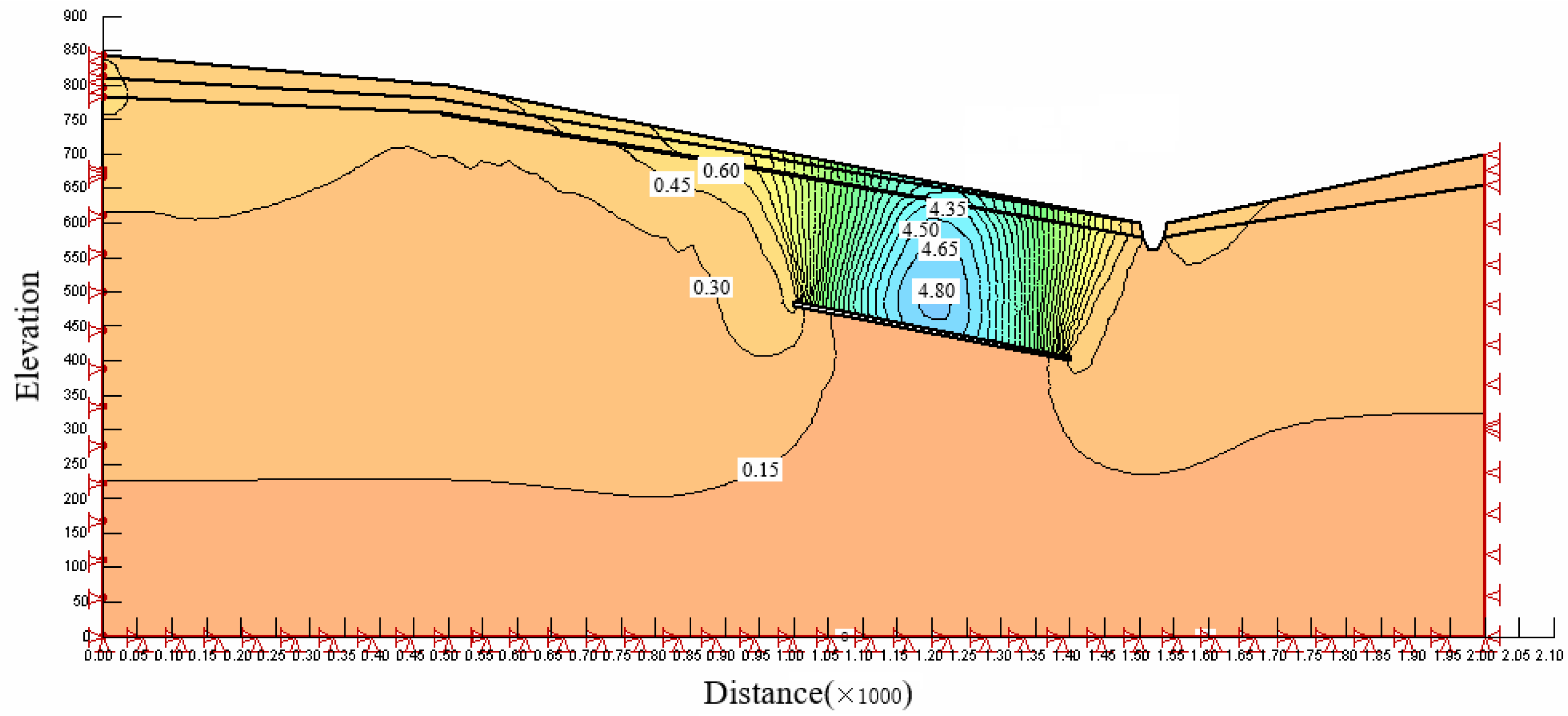
- (2)
- Stress analysis
4.3. Calculation Results of Landslide Stability
5. Discussion
5.1. Necessity of Combining Discrete Element Method with Finite Element Method to Analyze Landslide Formation Mechanism
5.2. Analysis of the Influencing Factors on the Landslide in the Coal Mining Subsidence Area
5.2.1. Internal Factors
5.2.2. Inducing Factors
- (1)
- Coal mining activities
- (2)
- Rain
5.3. Analysis of Formation Mechanism of Overlying Landslide in the Coal Mining Subsidence Area
5.3.1. Slope Deformation Stage
5.3.2. Slope Creep Stage
5.3.3. Landslide Movement Stage
5.3.4. Landslide Accumulation Stage
5.4. Comparison of Calculation Methods of Landslide Stability Coefficient
6. Conclusions
- (1)
- The slightly inclined bedding mudstone landslide in the Tanshan Coal Mine is 850 m long from east to west, 500 m wide from north to south, 10–20 m thick, 475,000 m2 in total area, 10,875,000 m3 in volume and has a sliding direction of 295°. The main body of the landslide is composed of Jurassic mudstone. From the material composition and scale of the landslide mass, the landslide belongs to a giant bedrock landslide. From analysis of landslide deformation characteristics and movement properties, the landslide is a traction landslide caused by a coal mining subsidence area.
- (2)
- Discrete element simulation analysis considering only the coal mining subsidence area shows that when the coal mining subsidence area collapse is completed, the creep deformation of the slope is not enough to lead to the formation of a landslide, which indicates that the formation of the landslide in the Tanshan Coal Mine is closely related to rainfall and surface water infiltration. When the contact surface between strong weathering and moderate weathering is set as a weak zone in the model, the simulation results are consistent with the actual sliding situation of the landslide.
- (3)
- The formation of the slightly inclined bedding mudstone landslide in the Tanshan Coal Mine is mainly due to the joint action of internal factors and inducing factors. The internal factors are mainly controlled by geotechnical types and engineering geological properties. The inducing factors are mainly coal mining activities and rainfall.
- (4)
- The sliding process of the landslide is divided into four stages: slope creep, slope deformation, landslide movement and landslide accumulation.
- (5)
- By comparing the calculation results of the limit equilibrium method and the finite element limit equilibrium method, we found that under the rainfall condition, the stability coefficient obtained by the two methods is about 5%, which is mainly due to the fact that the normal stress at the bottom of the strip in the limit equilibrium method is caused by the gravity of the strip and cannot simulate the actual stress distribution. The finite element limit equilibrium method not only calculates the stress closer to that of the real situation, but it also provides the local safety factor of each soil strip. Therefore, selecting the appropriate constitutive model, using the finite element method to simulate the stress distribution of the slope, and then importing it into the limit equilibrium equation for calculation makes the calculation results more accurate.
Author Contributions
Funding
Data Availability Statement
Acknowledgments
Conflicts of Interest
References
- Guo, G.; Wang, Y.; Ma, Z. A new Method for Ground Subsidence Control in Coal Mining. J. China Univ. Min. Technol. 2004, 33, 26–29. [Google Scholar]
- Wang, S.H.; Ren, Z.M.; Dou, Z.R.; Hu, Y.Q. Influence of surface subsidence in goaf of coal mine and its prevention countermeasures. Min. Saf. Environ. Prot. 2012, 39, 68–69+72. [Google Scholar]
- Yu, X.Y.; Zhang, E.Q. Mining Damage; Coal Industry Press: Beijing, China, 2010. [Google Scholar]
- Lv, Y.Q. Study on Deformation Failure Mode and Stability of Slope under Well Mining Conditions; Geological Publishing House: Beijing, China, 2014. [Google Scholar]
- Tang, F.Q.; Xia, Y.C.; Yao, W.Q. Mining Subsidence and Ground Protection in Loess Covered Mining Area; Science Press: Beijing, China, 2011. [Google Scholar]
- Xu, J.J. Survey and mechanism analysis of landslide in old coal mine goaf—An example of Lijialou landslide in Qingxu, Shanxi. Chin. J. Geol. Hazards Control 2015, 26, 25–29. [Google Scholar] [CrossRef]
- Li, T.F.; Li, X.; Yuan, W.N.; Li, S.D.; Hao, J.M.; Ma, C.F.; Chen, Y.; Wang, G. Current status and prospects of studies on mechanism of landslide geohazards induced by underground mining. J. Eng. Geol. 2011, 19, 831–838. [Google Scholar]
- Wang, Y.C.; Ju, N.P.; Zhao, J.J.; Xiang, X.Q. Formation mechanism of landslide above the mined out area in gently inclined coal beds. J. Eng. Geol. 2013, 21, 61–68. [Google Scholar]
- Luo, X.; Gong, S.; Huo, Z.; Li, H.; Ding, X. Application of Comprehensive Geophysical Prospecting Method in the Exploration of Coal Mined–Out Areas. Adv. Civ. Eng. 2019, 2019, 2368402. [Google Scholar] [CrossRef] [Green Version]
- Li, H.J.; Dong, J.H.; Zhu, Y.Q.; Zou, Y.X.; Ding, H. Characteristics and genesis mechanism of jianshanying landslide in Faer coal mine, Guizhou province. Sci. Technol. Eng. 2019, 19, 345–351. [Google Scholar]
- Yang, D.; Qiu, H.; Ma, S.; Liu, Z.; Du, C.; Zhu, Y.; Cao, M. Slow surface subsidence and its impact on shallow loess landslides in a coal mining area. Catena 2022, 209, 105830. [Google Scholar] [CrossRef]
- Benko, B.; Stead, D. The Frank slide: A reexamination of the failure mechanism. Can. Geotech. J. 1998, 35, 299–311. [Google Scholar] [CrossRef]
- Yin, Y.; Sun, P.; Zhang, M.; Li, B. Mechanism on apparent dip sliding of oblique inclined bedding rockslide at Jiweishan, Chongqing, China. Landslides 2011, 8, 49–65. [Google Scholar] [CrossRef]
- Xu, T.; Xu, Q.; Deng, M.; Ma, T.; Yang, T.; Tang, C. A numerical analysis of rock creep–induced slide: A case study from Jiweishan Mountain, China. Environ. Earth Sci. 2014, 72, 2111–2128. [Google Scholar] [CrossRef]
- Long, J.H.; Zhu, Q.H.; Ni, X.L. Study on a landslide model induced by underground resource exploitation: Taking mining–triggered landslide as an example. Coal Sci. Technol. 2021, 49, 181–187. [Google Scholar] [CrossRef]
- Dong, J.; Li, H.; Wang, Y.; Zhang, Y. Characteristics and monitoring–based analysis on deformation mechanism of Jianshanying landslide, Guizhou Province, southwestern China. Arabian J. Geosci. 2021, 14, 184. [Google Scholar] [CrossRef]
- Long, J.H.; Li, K.; Guo, X.J. A Review of the landslide stability and thrust under the influence of underground mining. J. Taiyuan Univ. Technol. 2019, 50, 141–152. [Google Scholar] [CrossRef]
- Zhang, D.; Wang, H.J.; Fan, Y.Q. Stability analysis of mining slope in mountain shallow coal seam. Saf. Coal Mines 2014, 45, 195–197. [Google Scholar] [CrossRef]
- Salmi, E.F.; Nazem, M.; Karakus, M. Numerical analysis of a large landslide induced by coal mining subsidence. Eng. Geol. 2017, 217, 141–152. [Google Scholar] [CrossRef]
- Dai, Z.; Zhang, L.; Wang, Y.; Jiang, Z.; Xu, S. Deformation and failure response characteristics and stability analysis of bedding rock slope after underground adverse slope mining. Bull. Eng. Geol. Environ. 2021, 80, 4405–4422. [Google Scholar] [CrossRef]
- Yang, X.J.; Hou, D.G.; Hao, Z.L.; Wang, E.Y. Fuzzy comprehensive evaluation of landslide caused by underground mining subsidence and its monitoring. Int. J. Environ. Pollut. 2016, 59, 284–302. [Google Scholar] [CrossRef]
- Liu, M.Q.; Liu, P.; Zhu, H.Z.; Wang, C.; Wang, C.H. Study on stability of mining landslide in shallow coal seam based on numerical analysis. Saf. Coal Mines 2021, 52, 225–230. [Google Scholar] [CrossRef]
- Tang, J.; Dai, Z.; Wang, Y.; Zhang, L. Fracture failure of consequent bedding rock slopes after underground mining in mountainous area. Rock Mech. Rock Eng. 2019, 52, 2853–2870. [Google Scholar] [CrossRef]
- Li, P.; Su, S.R.; Zeng, J.; Li, S.; Guo, M. Study on Formation Mechanism of Landslide with Accumulation Layer–Bedrock Contact Surface by Physical Model Test. J. Xi’an Technol. Univ. 2020, 40, 623–630+637. [Google Scholar] [CrossRef]
- Zhao, J.J.; Lin, B.; Ma, Y.T.; Zhang, X.D.; Lan, Z.Y.; Huang, R.Q. Physical modeling on deformation characteristics of overlying rock mass above mined–out area in gently inclined coal seam. J. China Coal Soc. 2016, 41, 1369–1374. [Google Scholar] [CrossRef]
- Fan, Z.Y.; Zhou, Y.; Liu, X.Y.; Li, S.H.; Zhang, X. Analysis of landslide mechanisms of the southern red bed slope in the No.2 opencast coal mine in eastern Shengli coal field. Chin. J. Rock Mech. Eng. 2016, 35, 4063–4072. [Google Scholar] [CrossRef]
- Dai, Z.Y.; Tang, J.X.; Shu, G.Y.; Teng, J.Y.; Wang, Y.L.; Liu, S. Deformation and fracture response characteristics of the bedding rock slope under the impact of the goaf. J. Saf. Environ. 2017, 17, 1294–1298. [Google Scholar] [CrossRef]
- Mao, Z.J.; Wang, X.K.; An, N.; Li, X.J.; Wei, R.Y. Water disaster susceptible areas in loess multi–arch tunnel construction under the lateral recharge condition. KSCE J. Civ. Eng. 2019, 23, 4564–4577. [Google Scholar] [CrossRef]
- Mao, Z.J.; Wang, X.K.; An, N.; Li, X.J.; Wei, R.Y.; Wang, Y.; Wu, H. Water leakage susceptible areas in loess multi–arch tunnel operation under the lateral recharge conditions. Environ. Earth Sci. 2020, 79, 368. [Google Scholar] [CrossRef]
- Tao, Z.G.; Zhang, B.; He, M.C. Research on mechanism and monitoring and early–warning technology of landslide in Luoshan mining area. Chin. J. Rock Mech. Eng. 2011, 30, 2931–2937. [Google Scholar]
- Liang, M.; Tang, F.Q. Surface monitoring and field data analysis during mining under mountain. J. Xi’an Min. Inst. 1994, 145–150. [Google Scholar] [CrossRef]
- Zhang, D.M.; Ma, L.X.; Zhang, J.; Hicher, P.Y.; Juang, C.H. Ground and tunnel responses induced by partial leakage in saturated clay with anisotropic permeability. Eng. Geol. 2015, 189, 104–115. [Google Scholar] [CrossRef]
- Zhao, J.J.; Xiao, J.G.; Xiang, X.Q.; Huang, R.Q.; Wang, Y.C.; Shi, W.B. Failure mechanism numerical simulation of mining landslide with gentle bedding coal strata. J. China Coal Soc. 2014, 39, 424–429. [Google Scholar] [CrossRef]
- Mao, Z.J.; Zhang, J.G.; Bi, Y.L.; Sun, W.B.; An, N. Numerical analysis of protection time effect on planting alfalfa in loess slope with shallow failure. Trans. Chin. Soc. Agric. Eng. (Trans. CSAE) 2022, 38, 72–83. [Google Scholar] [CrossRef]
- Shen, M.R.; Chen, J.F. Rock Mass Mechanics; Tongji University Press: Shanghai, China, 2015. [Google Scholar]
- Huang, B.; Fu, H.; Yu, Y.; Liu, C. Three–dimensional numerical simulation of Steven test by the combined finite–discrete element method. Chin. J. Energ. Mater. (Hanneng Cailiao) 2020, 28, 995–1002. [Google Scholar] [CrossRef]
- Li, J.; Feng, C.; Zhu, X.G.; Zhang, Y.M. Analysis of the Coal Fluidization Mining Process with the Continuous–Discontinuous Coupled Particle–Block Method. Geofluids 2022, 2022, 7001654. [Google Scholar] [CrossRef]
- Antolini, F.; Barla, M.; Gigli, G.; Giorgetti, A.; Intrieri, E.; Casagli, N. Combined finite–discrete numerical modeling of runout of the Torgiovannetto di Assisi rockslide in central Italy. Int. J. Géoméch. 2016, 16, 04016019. [Google Scholar] [CrossRef] [Green Version]
- Zhong, X.M.; Liu, W.; Chen, W.W.; Li, N.; Che, G.F.; Liu, Z.Z. Sensitivity of loess interface and complete–intense weathered mudstone inducing loess landslide. J. Lanzhou Univ. Nat. Sci. 2019, 55, 73–78. [Google Scholar] [CrossRef]
- Zheng, Y.; Chen, C.X.; Liu, T.T.; Zhang, W.; Song, Y.F. Slope failure mechanisms in dipping interbedded sandstone and mudstone revealed by model testing and distinct–element analysis. Bull. Eng. Geol. Environ. 2018, 77, 49–68. [Google Scholar] [CrossRef]
- Zhang, Z.L.; Wang, T. Numerical analysis of loess and weak intercalated layer failure behavior under direct shearing and cyclic loading. J. Mt. Sci. 2020, 17, 2796–2815. [Google Scholar] [CrossRef]
- Wang, X.G.; Lian, B.Q.; Kai, L.; Li, L. Trigger mechanism of loess–mudstone landslides inferred from ring shear tests and numerical simulation. J. Mt. Sci. 2021, 18, 2412–2426. [Google Scholar] [CrossRef]
- Mu, W.P.; Wu, X.; Qian, C.; Wang, K. Triggering mechanism and reactivation probability of loess–mudstone landslides induced by rainfall infiltration: A case study in Qinghai Province, Northwestern China. Environ. Earth Sci. 2020, 79, 22. [Google Scholar] [CrossRef]
- Hu, M.J.; Zhang, Z.H.; Zhao, P.; Tan, Z.Y.; Xia, S.H. Analysis on starting mechanism of gently inclined consequent mudstone landslide based on expansion force. Geotech. Investig. Surv. 2020, 48, 46–51. [Google Scholar]
- Mao, Z.J.; Bi, Y.L.; Geng, M.M.; An, N. Pull-out characteristics of herbaceous roots of alfalfa on the loess in different growth stages and their impacts on slope stability. Soil Tillage Res. 2023, 225, 105542. [Google Scholar] [CrossRef]
- Tang, K.M. Geotechnical Engineering; Wuhan University of Technology Press: Wuhan, China, 2001. [Google Scholar]
- Liang, Z.Q. Soil Mechanics and Subgrade; China Railway Press: Beijing, China, 1980. [Google Scholar]
- Wang, G.X. Landslide Science and Landslide Prevention Technology; China Railway Press: Beijing, China, 2004. [Google Scholar]
- Li, J.L. Slope Engineering; Chongqing University Press: Chongqing, China, 2013. [Google Scholar]
- Wang, D.P.; Liu, H.; Pei, X.J.; Sun, X.P.; Zhou, L.K.; Liu, Y.H. Dynamic response of shed tunnel cushion under rolling stone impact based on discrete element–finite difference coupling. J. Vib. Shock 2021, 40, 246–253. [Google Scholar] [CrossRef]
- Hung, C.; Liu, C.H.; Lin, G.W.; Leshchinsky, B. The Aso–Bridge coseismic landslide: A numerical investigation of failure and runout behavior using finite and discrete element methods. Bull. Eng. Geol. Environ. 2019, 78, 2459–2472. [Google Scholar] [CrossRef]
- Hung, C.; Liu, C.H.; Chang, C.M. Numerical investigation of rainfall–induced landslide in mudstone using coupled finite and discrete element analysis. Geofluids 2018, 2018, 9192019. [Google Scholar] [CrossRef] [Green Version]
- Hamdi, P.; Stead, D.; Elmo, D.; Töyrä, J. Use of an integrated finite/discrete element method–discrete fracture network approach to characterize surface subsidence associated with sub–level caving. Int. J. Rock Mech. Min. 2018, 103, 55–67. [Google Scholar] [CrossRef]
- Zhu, S.N.; Wei, Y.J.; Wang, P.; Zhuang, Z.H.; Wu, X.B.; Wang, W.P.; Yang, L. Research on deformation characteristics and instability mechanisms of large monoclinal layered bedrock landslide: A cause study of the Longjing landslide in Shizhu County, Chongqing. Chin. J. Rock Mech. Eng. 2021, 40, 739–750. [Google Scholar] [CrossRef]
- Yu, J.L.; Zhao, J.J.; Yan, H.Y.; Lai, Q.Y.; Huang, R.Q.; Liu, X.W.; Li, Y.C. Deformation and failure of a high–steep slope induced by multi–layer coal mining. J. Mt. Sci. 2020, 17, 2942–2960. [Google Scholar] [CrossRef]
- Wang, H.; Sun, P.; Zhang, S.; Han, S.; Li, X.; Wang, T.; Guo, Q.; Xin, P. Rainfall–induced landslide in loess area, Northwest China: A case study of the Changhe landslide on September 14, 2019, in Gansu Province. Landslides 2020, 17, 2145–2160. [Google Scholar] [CrossRef]
- Yan, G.; Yin, Y.; Huang, B.; Zhang, Z.; Zhu, S. Formation mechanism and characteristics of the Jinjiling landslide in Wushan in the Three Gorges Reservoir region, China. Landslides 2019, 16, 2087–2101. [Google Scholar] [CrossRef]


| Parameter | Bulk Density | |||||||||
|---|---|---|---|---|---|---|---|---|---|---|
| Name | kN/m3 | Pa | Pa | ° | Pa | Pa | Pa | ° | Pa | |
| Loess | 18 | 3.0 × 10⁵ | 1.2 × 10⁵ | 11 | 0 | 3.0 × 10⁴ | 1.2 × 10⁴ | 11 | 0 | |
| Strongly weathered mudstone | 25 | 5.0 × 10⁶ | 2.1 × 10⁶ | 21 | 0 | 5.0 × 10⁵ | 2.1 × 10⁵ | 21 | 0 | |
| Moderately weathered mudstone | 26 | 6.0 × 10⁶ | 2.3 × 10⁶ | 25 | 0 | 3.0 × 10⁵ | 1.2 × 10⁵ | 25 | 0 | |
| Weak zone | 27 | 3.0 × 10⁵ | 1.2 × 10⁵ | 7.6 | 0 | 3.0 × 10⁴ | 1.2 × 10⁴ | 7.6 | 0 | |
| Rock and Soil Type | Bulk Density (kN/m3) | (kPa) | (°) |
|---|---|---|---|
| Loess | 18 | 35 | 20 |
| Strongly weathered mudstone | 25 | 41 | 27 |
| Moderately weathered mudstone | 26 | 58 | 40 |
| Weak zone | 27 | 22 | 8 |
| Method | Moment Equilibrium | Force Balance | Normal Force between Bars/E | Force between Tangential Bars/X | Inclination and Relationship of X/E |
|---|---|---|---|---|---|
| Ordinary or Fellenius | Satisfied | Unsatisfied | Unsatisfied | Unsatisfied | There is no inter-strip force |
| simplified Bishop | Satisfied | Unsatisfied | Satisfied | Unsatisfied | Horizontal direction |
| simplified Janbu | Unsatisfied | Satisfied | Satisfied | Unsatisfied | Horizontal direction |
| Mongenstern and Price | Satisfied | Satisfied | Satisfied | Satisfied | Variables, Defining functions |
| Condition | Rock and Soil Type | Bulk Density (kN/m2) | (kPa) | (°) | Poisson’s Ratio |
|---|---|---|---|---|---|
| Natural | Loess | 18 | 35 | 20 | 0.35 |
| Loess soil | 16 | 32 | 18 | 0.35 | |
| Strongly weathered mudstone | 25 | 41 | 27 | 0.3 | |
| Slip zone | 27 | 28 | 13 | 0.4 | |
| Rainfall | Loess | 18 | 35 | 20 | 0.35 |
| Saturated loess soil | 22 | 25 | 16 | 0.35 | |
| Loess soil | 19 | 32 | 18 | 0.35 | |
| Strongly weathered mudstone | 25 | 41 | 27 | 0.3 | |
| Slip zone | 29 | 22 | 8 | 0.4 |
| Method | Ordinary | Bishop | Janbu | M–P | Finite Element | |
|---|---|---|---|---|---|---|
| Condition | ||||||
| Natural | 1.905 | 2.095 | 1.936 | 1.948 | 1.802 | |
| Rainfall | 1.093 | 1.150 | 1.088 | 1.094 | 1.059 | |
Publisher’s Note: MDPI stays neutral with regard to jurisdictional claims in published maps and institutional affiliations. |
© 2022 by the authors. Licensee MDPI, Basel, Switzerland. This article is an open access article distributed under the terms and conditions of the Creative Commons Attribution (CC BY) license (https://creativecommons.org/licenses/by/4.0/).
Share and Cite
Zhong, J.; Mao, Z.; Ni, W.; Zhang, J.; Liu, G.; Zhang, J.; Geng, M. Analysis of Formation Mechanism of Slightly Inclined Bedding Mudstone Landslide in Coal Mining Subsidence Area Based on Finite–Discrete Element Method. Mathematics 2022, 10, 3995. https://doi.org/10.3390/math10213995
Zhong J, Mao Z, Ni W, Zhang J, Liu G, Zhang J, Geng M. Analysis of Formation Mechanism of Slightly Inclined Bedding Mudstone Landslide in Coal Mining Subsidence Area Based on Finite–Discrete Element Method. Mathematics. 2022; 10(21):3995. https://doi.org/10.3390/math10213995
Chicago/Turabian StyleZhong, Jiaxin, Zhengjun Mao, Wankui Ni, Jia Zhang, Gaoyang Liu, Jinge Zhang, and Mimi Geng. 2022. "Analysis of Formation Mechanism of Slightly Inclined Bedding Mudstone Landslide in Coal Mining Subsidence Area Based on Finite–Discrete Element Method" Mathematics 10, no. 21: 3995. https://doi.org/10.3390/math10213995