Analysis and Predictability of the Hydrological Response of Mountain Catchments to Heavy Rain on Snow Events: A Case Study in the Spanish Pyrenees


Abstract
:1. Introduction
- To assess the suitability of snow models coupled with atmospheric models to simulate ROS events
- To estimate the spatial distribution of discharge in several sub-catchments
- To estimate the relative forcing of meteorological variables to snow melt
- To estimate the relative contribution of snowmelt and rainfall to the final river discharge
- To estimate how much time in advance a weather model can give an early warning of dangerous floods.
2. Materials and Methods
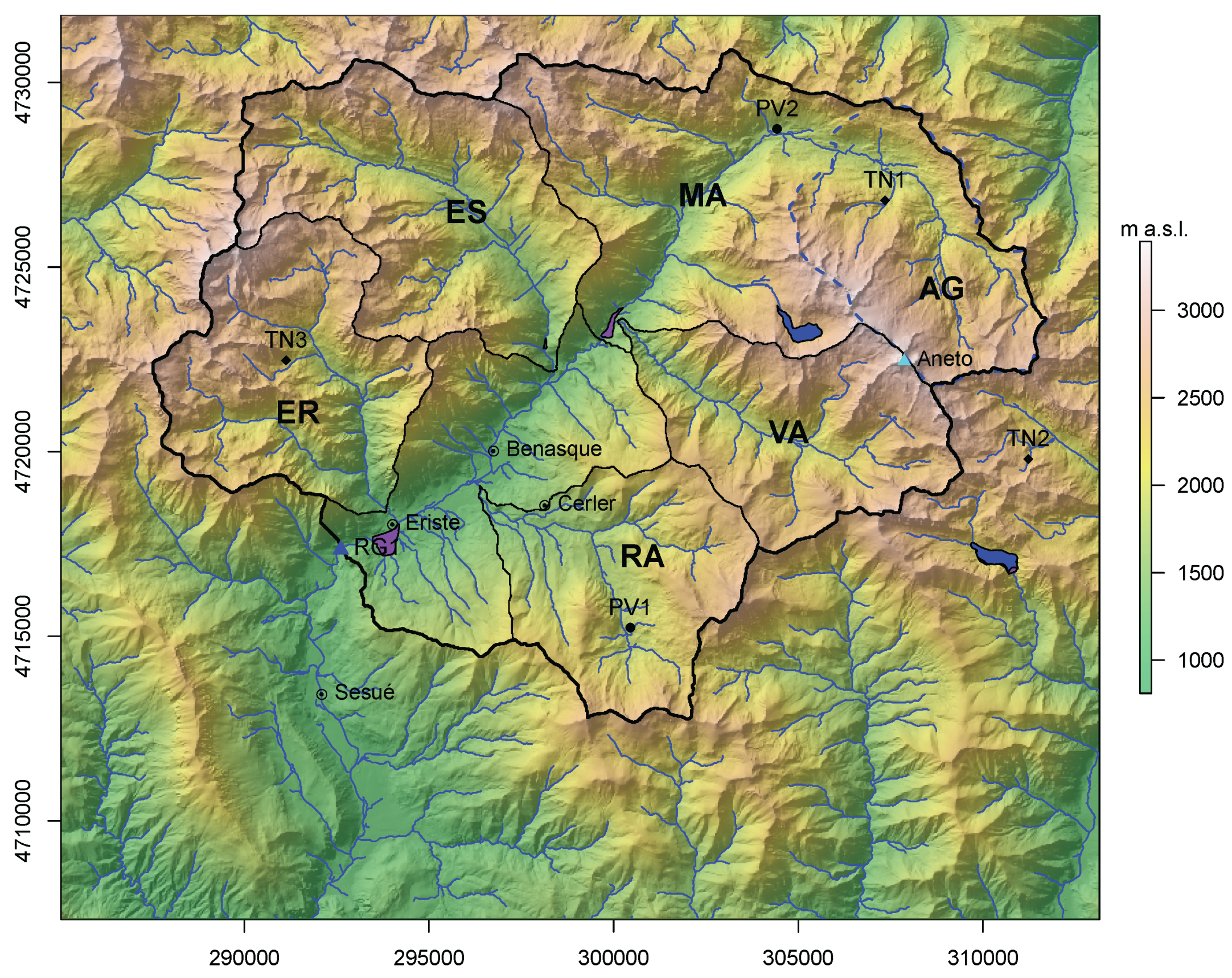
2.1. Site of Study
2.2. Data
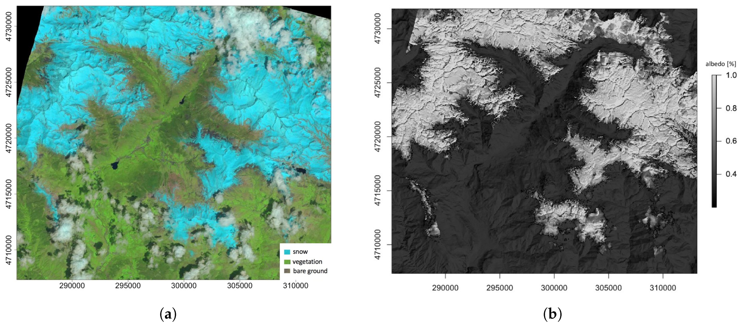
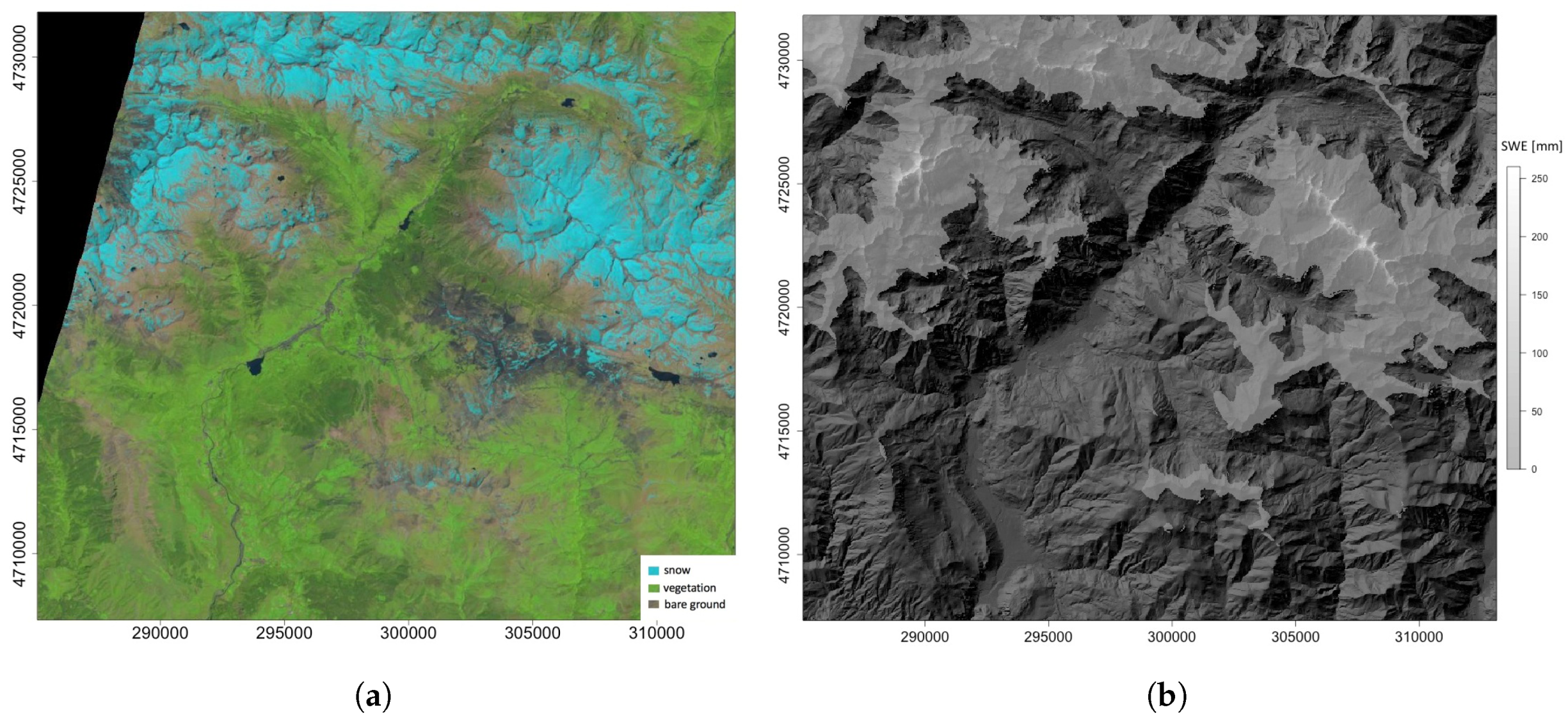
2.3. Remote Sensing
2.4. Snow Model
2.5. Atmospheric Model
2.6. Discharge
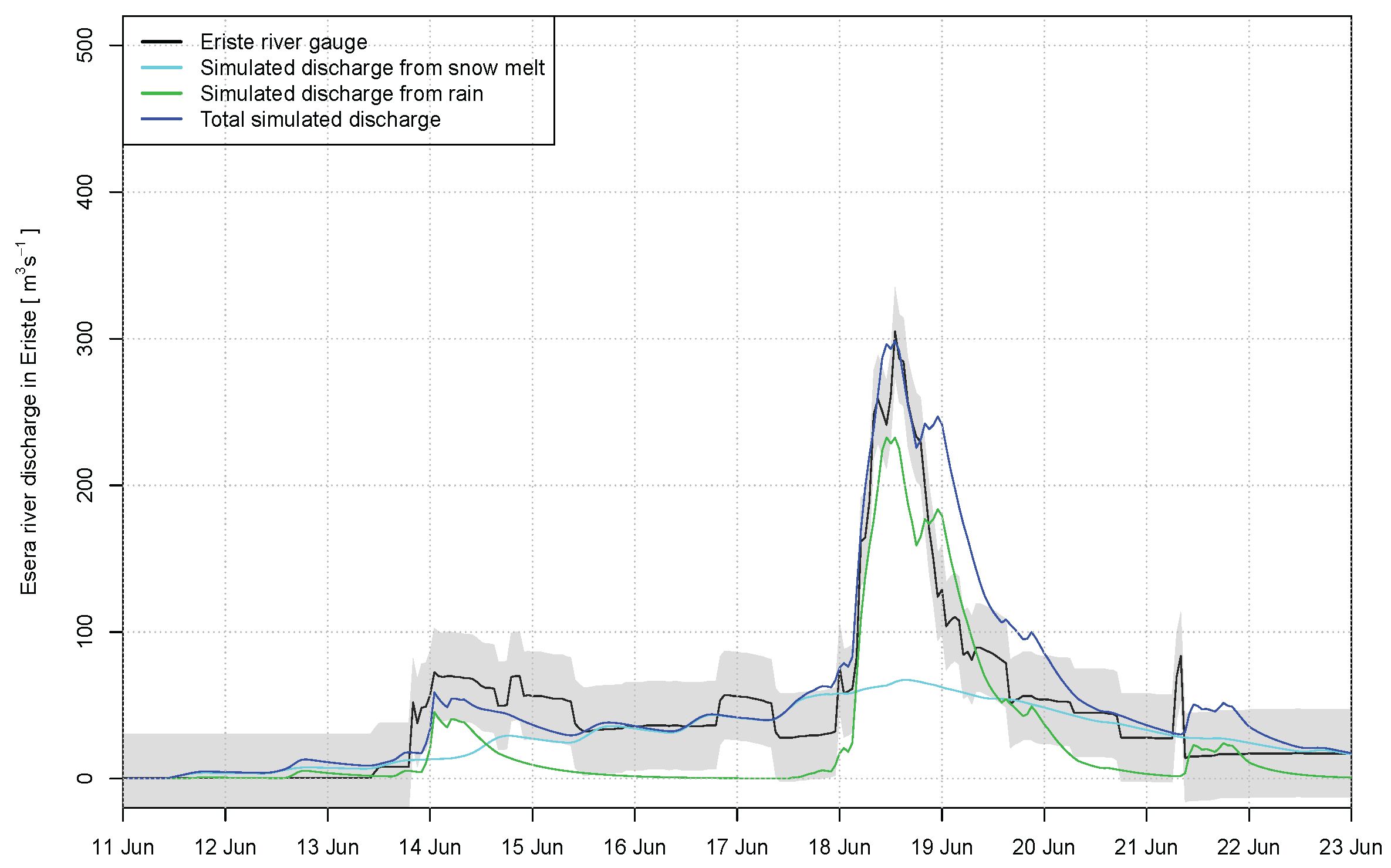
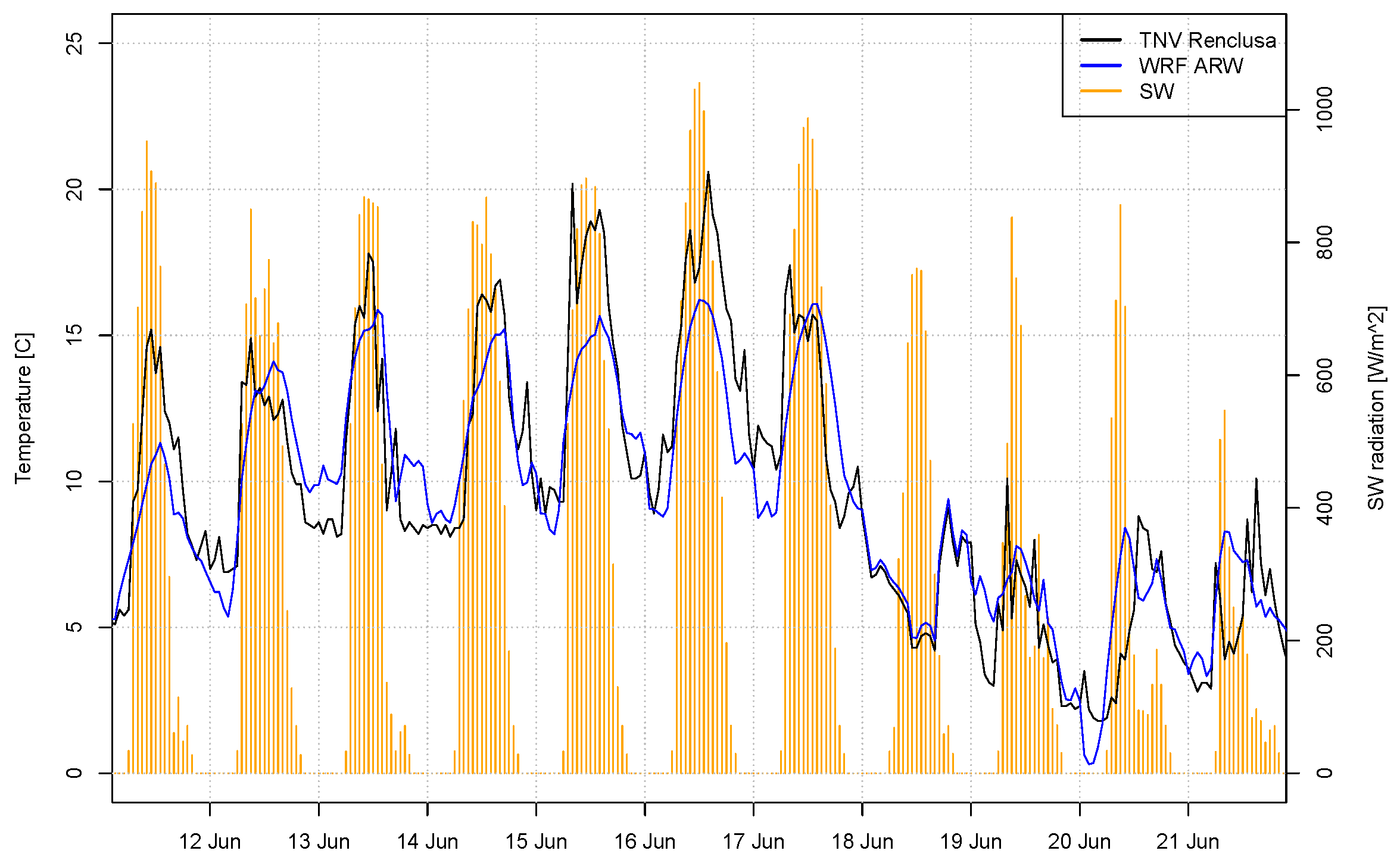
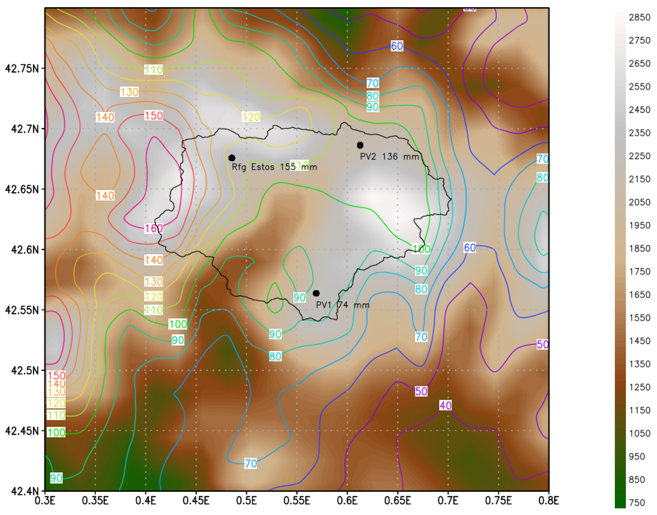
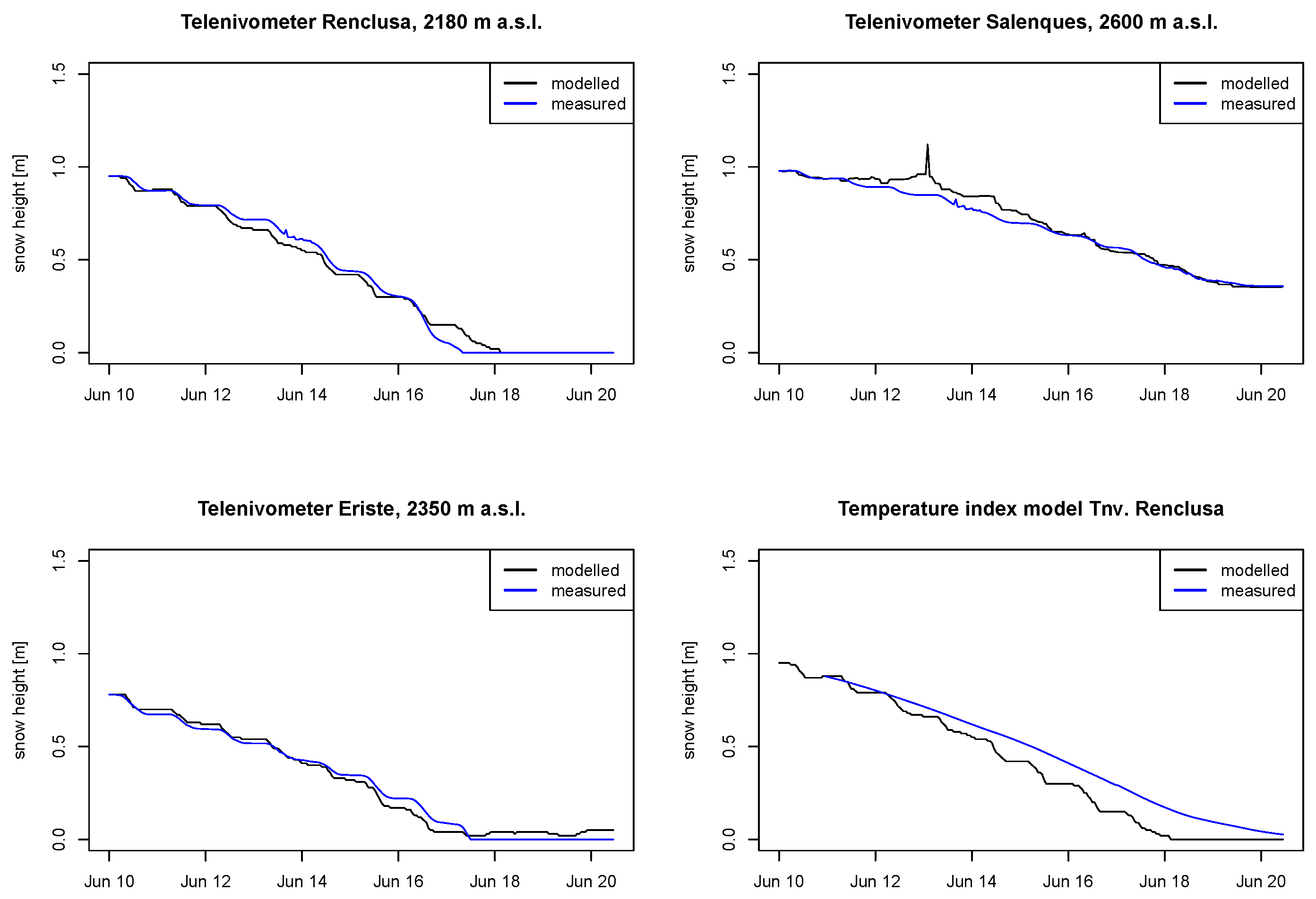
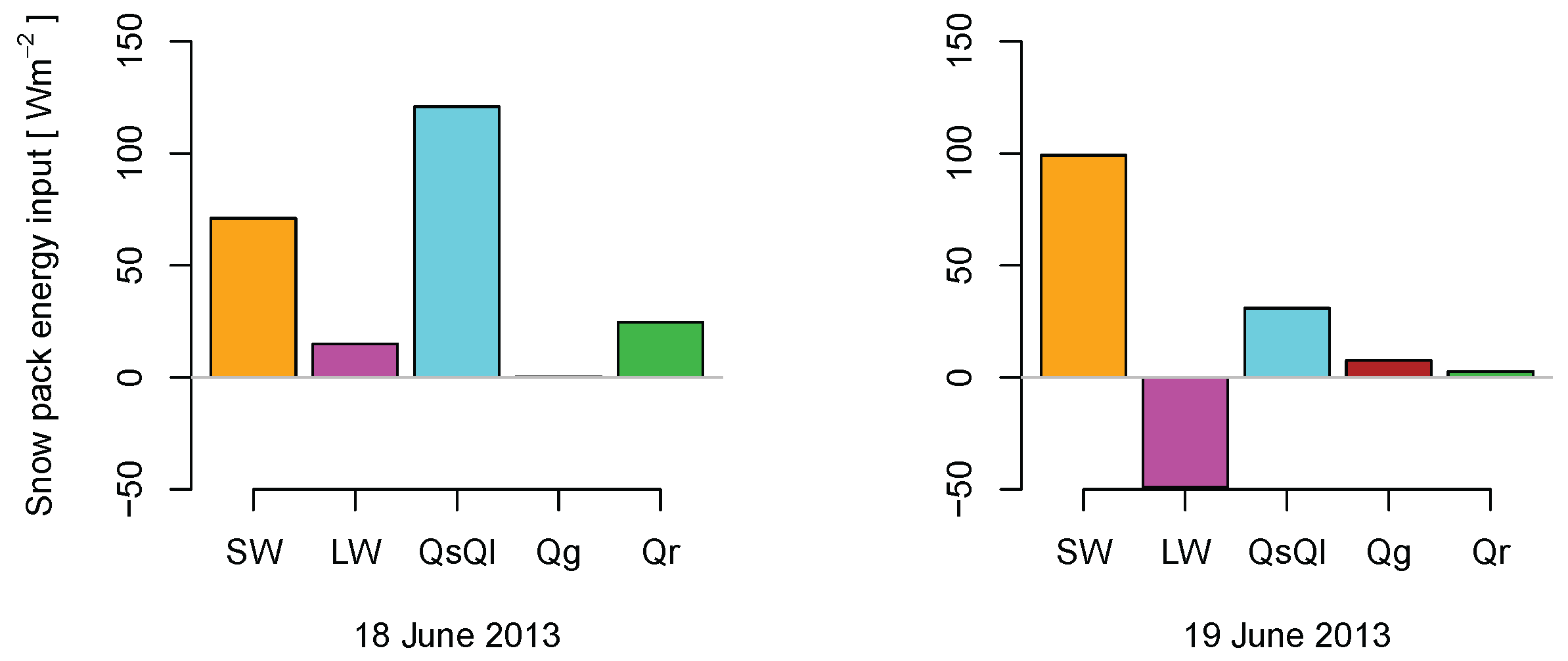
3. Results
4. Discussion
5. Conclusions
Acknowledgments
Author Contributions
Conflicts of Interest
Abbreviations
| ARW | Advanced research WRF core |
| DEM | Digital Elevation Model |
| GFS | Global Forecast System |
| HPC | High Performance Computing |
| ROS | Rain On Snow |
| SAIH | Automatic Hydrologic Information System of the Ebro river basin |
| SLR | Single Linear Reservoir |
| SWE | Snow Water Equivalent |
| UTM | Universal Transverse Mercator |
| WRF | Weather Research and Forecasting Model |
Appendix A

| Temperature | |||
| 1.250 | 0.149 | 0.317 | |
| – | −0.550 | −0.565 | |
| – | – | −0.183 | |
| Water vapour | |||
| 1.610 | 0.351 | 0.396 | |
| – | −0.628 | −0.512 | |
| – | – | −0.180 |
References
- Añel, J.A.; López-Moreno, J.I.; Otto, F.E.L.; Vicente-Serrano, S.; Schaller, N.; Massey, N.; Buisán, S.T.; Allen, M.R. The extreme snow accumulation in the Western Spanish pyrennes during winter and spring 2013. In Explaining Extreme Events of 2013 from a Climate Perspective; Herring, S.C., Hoerling, M.P., Peterson, T.C., Stott, P.A., Eds.; Bulletin of the American Meteorological Society: Providence, RI, USA, 2014; Volume 95, Chapter 21; pp. S73–S76. [Google Scholar]
- Singh, P.; Spitzbart, G.; Hübl, H.; Weinmeister, H. Hydrological response of snowpack under rain-on-snow events: A field study. J. Hydrol. 1997, 202, 1–20. [Google Scholar] [CrossRef]
- Morán-Tejeda, E.; López-Moreno, J.; Stoffel, M.; Beniston, M. Rain-on-snow events in Switzerland: Recent observations and projections for the 21st century. Clim. Res. 2016, 71, 111–125. [Google Scholar] [CrossRef]
- Kattelmann, R. Flooding from Rain-on-Snow Events in the Sierra Nevada. In Proceedings of the North American Water and Environment Congress & Destructive Water (ASCE), Anaheim, CA, USA, 22–28 June 1996; Bathala, C., Ed.; pp. 1145–1146. [Google Scholar]
- Brunengo, M.J. A method of modeling the frequency characteristics of daily snow amount, for stochastic simulation of rain-on-snowmelt events. In Proceedings of the 58th Annual Western Snow Conference, Sacramento, CA, USA, 17–19 April 1990; Volume 58, pp. 110–121. [Google Scholar]
- McCabe, G.J.; Hay, L.E.; Clark, M.P.; McCabe, G.J.; Hay, L.E.; Clark, M.P. Rain-on-Snow Events in the Western United States. Bull. Am. Meteorol. Soc. 2007, 88, 319–328. [Google Scholar] [CrossRef]
- Harr, R. Some characteristics and consequences of snowmelt during rainfall in western Oregon. J. Hydrol. 1981, 53, 277–304. [Google Scholar] [CrossRef]
- Harr, R.D. Effects of Clearcutting on Rain-on-Snow Runoff in Western Oregon: A New Look at Old Studies. Water Resour. Res. 1986, 22, 1095–1100. [Google Scholar] [CrossRef]
- Christner, J.; Harr, R.D. Peak streamflows from the transient snow zone, western Cascades, Oregon. In Proceedings of the 50th Annual Western Snow Conference, Reno, NC, USA, 19–23 April 1982. [Google Scholar]
- Bergman, J.A. Rain-on-snow and soil mass failure in the Sierra Nevada of California. In Landslide Activity in the Sierra Nevada during 1982 and 1983; DeGraff, J.V., Ed.; USDA Forest Service: San Francisco, CA, USA, 1987; pp. 15–26. [Google Scholar]
- Jones, J.A.; Perkins, R.M. Extreme flood sensitivity to snow and forest harvest, western Cascades, Oregon, United States. Water Resour. Res. 2010, 46, W12512. [Google Scholar] [CrossRef]
- Sandersen, F.; Bakkehøi, S.; Hestnes, E.; Lied, K. The influence of meteorological factors on the initiation of debris flows, rockfalls, rockslides and rockmass stability. Publ. Nor. Geotek. Inst. 1997, 201, 97–114. [Google Scholar]
- Marks, D.; Kimball, J.; Tingey, D.; Link, T. The sensitivity of snowmelt processes to climate conditions and forest cover during rain-on-snow: A case study of the 1996 Pacific Northwest flood. Hydrol. Process. 1998, 12, 1569–1587. [Google Scholar] [CrossRef]
- Van Heeswijk, M.; Kimball, J.; Marks, D. Simulation of Water Available for Runoff in Clearcut Forest Openings During Rain-on-Snow Events in the Western Cascade Range of Oregon and Washington; Technical Report; U.S. Geological Survey: Tacoma, WA, USA, 1996.
- Mazurkiewicz, A.B.; Callery, D.G.; McDonnell, J.J. Assessing the controls of the snow energy balance and water available for runoff in a rain-on-snow environment. J. Hydrol. 2008, 354, 1–14. [Google Scholar] [CrossRef]
- Pradhanang, S.M.; Frei, A.; Zion, M.; Schneiderman, E.M.; Steenhuis, T.S.; Pierson, D. Rain-on-snow runoff events in New York. Hydrol. Process. 2013, 27, 3035–3049. [Google Scholar] [CrossRef]
- Shanley, J.; Chalmers, A. The effect of frozen soil on snowmelt runoff at Sleepers River, Vermont. Hydrol. Process. 1999, 13, 1843–1857. [Google Scholar] [CrossRef]
- Niu, G.Y.; Yang, Z.L. Effects of vegetation canopy processes on snow surface energy and mass balances. J. Geophys. Res. Atmos. 2004, 109. [Google Scholar] [CrossRef]
- Westrick, K.J.; Mass, C.F.; Westrick, K.J.; Mass, C.F. An Evaluation of a High-Resolution Hydrometeorological Modeling System for Prediction of a Cool-Season Flood Event in a Coastal Mountainous Watershed. J. Hydrometeorol. 2001, 2, 161–180. [Google Scholar] [CrossRef]
- Fiori, E.; Comellas, A.; Molini, L.; Rebora, N.; Siccardi, F.; Gochis, D.; Tanelli, S.; Parodi, A. Analysis and hindcast simulations of an extreme rainfall event in the Mediterranean area: The Genoa 2011 case. Atmos. Res. 2014, 138, 13–29. [Google Scholar] [CrossRef]
- Würzer, S.; Jonas, T.; Wever, N.; Lehning, M. Influence of Initial Snowpack Properties on Runoff Formation during Rain-on-Snow Events. J. Hydrometeorol. 2016, 17, 1801–1815. [Google Scholar] [CrossRef]
- Wever, N.; Jonas, T.; Fierz, C.; Lehning, M. Model simulations of the modulating effect of the snow cover in a rain-on-snow event. Hydrol. Earth Syst. Sci. 2014, 18, 4657–4669. [Google Scholar] [CrossRef]
- Förster, K.; Meon, G.; Marke, T.; Strasser, U. Effect of meteorological forcing and snow model complexity on hydrological simulations in the Sieber catchment (Harz Mountains, Germany). Hydrol. Earth Syst. Sci. 2014, 18, 4703–4720. [Google Scholar] [CrossRef]
- Skamarock, W.C.; Klemp, J.B.; Dudhia, J.; Gill, D.O.; Barker, D.M.; Duda, M.G.; Huang, X.Y.; Wang, W.; Powers, J.G. A Description of the Advanced Research WRF Version 3. NCAR/TN-475+STR; Technical Report; NCAR: Boulder, CO, USA, 2008. [Google Scholar]
- García-Ruiz, J.M.; Puigdefábregas, J.; Creus, J. Los Recursos Hídricos Superficiales del Alto Aragón (Surface Water Resources of the High Aragón); Technical Report; Instituto de Estudios Altoaragoneses: Huesca, Spain, 1985. [Google Scholar]
- Martínez de Pisón, E. Morfoestructuras del Valle de Benasque (Pirineo Aragonés); Anales de Geografía de la Universidad Complutense: Madrid, Spain, 1990; pp. 121–148. [Google Scholar]
- López-Moreno, J.I.; Beguería, S.; García-Ruiz, J.M. Influence of the Yesa reservoir on floods of the Aragón River, central Spanish Pyrenees. Hydrol. Earth Syst. Sci. 2002, 6, 753–762. [Google Scholar] [CrossRef]
- Chueca Cía, J.; Andrés, A.J.; Saz Sánchez, M.; Novau, J.C.; López Moreno, J. Responses to climatic changes since the Little Ice Age on Maladeta Glacier (Central Pyrenees). Geomorphology 2005, 68, 167–182. [Google Scholar]
- Rijckborst, H. Hydrology of the Upper-Garonne basin (Valle de Arán, Spain). Leidse Geol. Meded. 1967, 40, 1–74. [Google Scholar]
- Lampre, F. Estudio Geomorfológico de Ballibierna, Macizo de la Maladeta, Pirineo Aragonés. Modelado Glaciar y Periglaciar (Geomorphologic Study of Ballibierna, Maladeta Sector, Aragonés Pyrenees. Glacial and Periglacial Forms); Technical Report; Consejo de Protección de la Naturaleza de Aragón: Zaragoza, Spain, 1998. [Google Scholar]
- Del Barrio, G.; Creus, J.; Puigdefabregas, J. Thermal Seasonality of the High Mountain Belts of the Pyrenees. Mt. Res. Dev. 1990, 10, 227. [Google Scholar] [CrossRef]
- López-Moreno, J.I.; Nogués-Bravo, D. Interpolating local snow depth data: An evaluation of methods. Hydrol. Process. 2006, 20, 2217–2232. [Google Scholar] [CrossRef]
- Hall, D.; Riggs, G. Normalized-Difference Snow Index (NDSI). In Encyclopedia of Snow, Ice and Glaciers SE-376; Singh, V., Singh, P., Haritashya, U., Eds.; Encyclopedia of Earth Sciences Series; Springer: Dordrecht, The Netherlands, 2011; pp. 779–780. [Google Scholar]
- Wang, Z.; Erb, A.M.; Schaaf, C.B.; Sun, Q.; Liu, Y.; Yang, Y.; Shuai, Y.; Casey, K.A.; Román, M.O. Early spring post-fire snow albedo dynamics in high latitude boreal forests using Landsat-8 OLI data. Remote Sens. Environ. 2016, 185, 71–83. [Google Scholar] [CrossRef]
- Corripio, J.G. Vectorial algebra algorithms for calculating terrain parameters from DEMs and the position of the sun for solar radiation modelling in mountainous terrain. Int. J. Geogr. Inf. Sci. 2003, 17, 1–23. [Google Scholar] [CrossRef]
- Corripio, J.G. Insol: Solar Radiation. R Package. 2013. Available online: https://cran.r-project.org/package=insol (accessed on 28 March 2017).
- Corripio, J.G. Modelling the Energy Balance of High Altitude Glacierised Basins in the Central Andes. Ph.D. Thesis, The University of Edinburgh, Edinburgh, UK, 2003. [Google Scholar]
- Corripio, J.G.; Purves, R.S. Surface Energy Balance of High Altitude Glaciers in the Central Andes: The Effect of Snow Penitentes. In Climate and Hydrology in Mountain Areas; de Jong, C., Collins, D., Ranzi, R., Eds.; Wiley: Hoboken, NJ, USA, 2005; pp. 15–27. [Google Scholar]
- Dadic, R.; Corripio, J.G.; Burlando, P. Mass-balance estimates for Haut Glacier d’Arolla, Switzerland, from 2000 to 2006 using DEMs and distributed mass-balance modeling. Ann. Glaciol. 2008, 49, 22–26. [Google Scholar] [CrossRef]
- Iziomon, M.G.; Mayer, H.; Matzarakis, A. Downward atmospheric longwave irradiance under clear and cloudy skies: Measurement and parameterization. J. Atmos. Sol. Terr. Phys. 2003, 65, 1107–1116. [Google Scholar] [CrossRef]
- Businger, J.A.; Yaglom, A.M. Introduction to Obukhov’s paper on ‘Turbulence in an atmosphere with non-uniform temperature’. Bound. Layer Meteorol. 1971, 2, 3–6. [Google Scholar] [CrossRef]
- Obukhov, A.M. Turbulence in an Atmosphere with Non-Uniform Temperature. Bound. Layer Meteorol. 1971, 2, 7–29. [Google Scholar] [CrossRef]
- Andreas, E.L. A theory for the scalar roughness and the scalar transfer coefficients over snow and sea ice. Bound. Layer Meteorol. 1987, 38, 159–184. [Google Scholar] [CrossRef]
- Andreas, E.L. Parameterizing Scalar Transfer over Snow and Ice: A Review. J. Hydrometeorol. 2002, 3, 417–432. [Google Scholar] [CrossRef]
- Sexstone, G.A.; Clow, D.W.; Stannard, D.I.; Fassnacht, S.R. Comparison of methods for quantifying surface sublimation over seasonally snow-covered terrain. Hydrol. Process. 2016, 30, 3373–3389. [Google Scholar] [CrossRef]
- Brun, E.; Martin, E.; Simon, V.; Gendre, C.; Coleou, C. An energy and mass model of snow cover suitable for operational avalanche forecasting. J. Glaciol. 1989, 35, 333–342. [Google Scholar] [CrossRef]
- Oke, T.J. Boundary Layer Climates; Methuen: London, UK, 1987. [Google Scholar]
- Fukami, H.; Kojima, K.; Aburakawa, H. The extinction and absorption of solar radiation within a snow cover. Ann. Glaciol. 1985, 6, 118–122. [Google Scholar] [CrossRef]
- Warren, S.G. Optical properties of snow. Rev. Geophys. Space Phys. 1982, 20, 67–89. [Google Scholar] [CrossRef]
- Brock, B.W.; Willis, I.C.; Sharp, M.J. Measurement and parameterisation of albedo variations at Haut Glacier d’Arolla, Switzerland. J. Glaciol. 2000, 46, 675–688. [Google Scholar] [CrossRef]
- Oerlemans, J.; Knapp, W.H. A 1 year record of global radiation and albedo in the ablation zone of Morteratschgletscher, Switzerland. J. Glaciol. 1998, 44, 231–238. [Google Scholar] [CrossRef]
- Frick, C. The Numerical Modeling of Wet Snowfall Events. Ph.D. Thesis, ETH Zürich, Zürich, Switzerland, 2012. [Google Scholar]
- Tobin, C.; Rinaldo, A.; Schaefli, B. Snowfall Limit Forecasts and Hydrological Modeling. J. Hydrometeorol. 2012, 13, 1507–1519. [Google Scholar] [CrossRef]
- Bukovsky, M.S.; Karoly, D.J. Precipitation simulations using WRF as a nested regional climate model. J. Appl. Meteorol. Climatol. 2009, 48, 2152–2159. [Google Scholar] [CrossRef]
- Cassola, F.; Ferrari, F.; Mazzino, A. Numerical simulations of Mediterranean heavy precipitation events with the WRF model: A verification exercise using different approaches. Atmos. Res. 2015, 164, 210–225. [Google Scholar] [CrossRef]
- Fernández-González, S.; Valero, F.; Sánchez, J.L.; Gascón, E.; López, L.; García-Ortega, E.; Merino, A. Numerical simulations of snowfall events: Sensitivity analysis of physical parameterizations. J. Geophys. Res. Atmos. 2015, 120, 10,130–10,148. [Google Scholar] [CrossRef]
- Pennelly, C.; Reuter, G.; Flesch, T. Verification of the WRF model for simulating heavy precipitation in Alberta. Atmos. Res. 2014, 135, 172–192. [Google Scholar] [CrossRef]
- Trapero, L.; Bech, J.; Lorente, J. Numerical modelling of heavy precipitation events over Eastern Pyrenees: Analysis of orographic effects. Atmos. Res. 2013, 123, 368–383. [Google Scholar] [CrossRef]
- Wang, W.; Bruyere, C.; Duda, M.; Dudhia, J.; Gill, D.; Kavulich, M.; Keene, K.; Lin, H.C.; Michalakes, J.; Rizvi, S.; et al. User’s Guides for the Advanced Research WRF (ARW) Modeling System, version 3; Technical Report; National Center for Atmospheric Research NCAR, 2014. Available online: http://www2.mmm.ucar.edu/wrf/users/docs/user_guide_V3/contents.html (accessed on 28 March 2017).
- GDAL Development Team. GDAL—Geospatial Data Abstraction Library, version 2.1.1; 2016. Available online: http://www.gdal.org/ (accessed on 28 March 2017).
- Pedersen, J.T.; Peters, J.C.; Helweg, O.J. Hydrographs by Single Linear Reservoir Model; Technical Report No. HY5; US Army Corps of Engineers, Hydrologic Engineering Center: Davis, CA, USA, 1980. [Google Scholar]
- Chow, V. Open-Channel Hydraulics; McGraw-Hill: New York, NY, USA, 1959. [Google Scholar]
- Hannah, D.M.; Gurnell, A.M. A conceptual, linear reservoir runoff model to investigate melt season changes in cirque glacier hydrology. J. Hydrol. 2001, 246, 123–141. [Google Scholar] [CrossRef]
- Neteler, M.; Bowman, M.H.; Landa, M.; Metz, M. GRASS GIS: A multi-purpose Open Source GIS. Environ. Model. Softw. 2012, 31, 124–130. [Google Scholar] [CrossRef]
- Freixes, A.; Monterde, M.; Ramoneda, J. Tracer tests in the Joèu karstic system (Aran Valley, Central Pyrennes, NE Spain). In Tracer Hydrology 97; Kranjc, K., Ed.; Balkema: Rotterdam, The Netherlands, 1997; pp. 219–225. [Google Scholar]
- Monterde García, M. El sistema kárstico de Uelhs Deth Joèu. Treb. Soc. Catalana Geogr. 2001, 52, 233–244. [Google Scholar]
- Georges, C.; Kaser, G. Ventilated and unventilated air temperature measurements for glacier-climate studies on a tropical high mountain site. J. Geophys. Res. 2002, 107, ACL 15-1–ACL 15-10. [Google Scholar] [CrossRef]
- Respuesta Hidrológica al Evento de Precipitación de Junio de 2013 en el Pirineo Central. Investigaciones Geográficas 2014, 62, 5–21.
- Nash, J.E.; Sutcliffe, J.V. River flow forecasting through conceptual models part I—A discussion of principles. J. Hydrol. 1970, 10, 282–290. [Google Scholar] [CrossRef]
- Byers, H.R.; Moses, H.; Harney, P.J. Measurement of Rain Temperature. J. Meteorol. 1949, 6, 51–55. [Google Scholar] [CrossRef]
- Mass, C.F.; Ovens, D.; Westrick, K.; Colle, B.A. Does increasing horizontal resolution produce more skillful forecasts? The results of two years of real-time numerical weather prediction over the Pacific Northwest. Bull. Am. Meteorol. Soc. 2002, 83, 407–430. [Google Scholar] [CrossRef]
- Liston, G.E.; Elder, K. A micrometeorological distribution system for high-resolution terrestrial modeling applications (MicroMet). J. Hydrometeorol. 2006, 7, 217–234. [Google Scholar] [CrossRef]
- Thornton, P.E.; Running, S.W.; White, M.A. Generating surfaces of daily meteorological variables over large regions of complex terrain. J. Hydrol. 1997, 190, 214–251. [Google Scholar] [CrossRef]
- Lehning, M.; Grünewald, T.; Schirmer, M. Mountain Snow Distribution Governed by an Altitudinal Gradient and Terrain Roughness. Geophys. Res. Lett. 2011. [Google Scholar] [CrossRef]
- Daly, C.; Halbleib, M.; Smith, J.I.; Gibson, W.P.; Doggett, M.K.; Taylor, G.H.; Curtis, J.; Pasteris, P.P. Physiographically sensitive mapping of climatological temperature and precipitation across the conterminous United States. Int. J. Climatol. 2008, 28, 2031–2064. [Google Scholar] [CrossRef]
- Blanchet, J.; Marty, C.; Lehning, M. Extreme value statistics of snowfall in the Swiss Alpine region. Water Resour. Res. 2009, 45. [Google Scholar] [CrossRef]
- Sevruk, B. Regional Dependency of Precipitation-Altitude Relationship in the Swiss Alps. Clim. Chang. 1997, 36, 355–369. [Google Scholar] [CrossRef]
- Sevruk, B.; Mieglitz, K. The effect of topography, season and weather situation on daily precipitation gradients in 60 Swiss valleys. Water Sci. Technol. 2002, 45, 41–48. [Google Scholar] [PubMed]
- Pomeroy, J.W.; Fang, X.; Marks, D.G. The cold rain-on-snow event of June 2013 in the Canadian Rockies—Characteristics and diagnosis. Hydrol. Process. 2016, 30, 2899–2914. [Google Scholar] [CrossRef]
- Boscarello, L.; Ravazzani, G.; Rabuffetti, D.; Mancini, M. Integrating glaciers raster-based modelling in large catchments hydrological balance: The Rhone case study. Hydrol. Process. 2014, 28, 496–508. [Google Scholar] [CrossRef]
- Ceppi, A.; Ravazzani, G.; Salandin, A.; Rabuffetti, D.; Montani, A.; Borgonovo, E.; Mancini, M. Effects of temperature on flood forecasting: Analysis of an operative case study in Alpine basins. Nat. Hazards Earth Syst. Sci. 2013, 13, 1051–1062. [Google Scholar] [CrossRef]
- Minder, J.R.; Durran, D.R.; Roe, G.H. Mesoscale Controls on the Mountainside Snow Line. J. Atmos. Sci. 2011, 68, 2107–2127. [Google Scholar] [CrossRef]
- White, A.B.; Neiman, P.J.; Ralph, F.M.; Kingsmill, D.E.; Persson, P.O.G. Coastal Orographic Rainfall Processes Observed by Radar during the California Land-Falling Jets Experiment. J. Hydrometeorol. 2002, 4, 264. [Google Scholar] [CrossRef]
- Bird, R.E.; Hulstrom, R.L. A Simplified Clear Sky Model for Direct and Diffuse Insolation on Horizontal Surfaces; Technical Report SERI/TR-642-761; Solar Energy Research Institute: Golden, CO, USA, 1981. [Google Scholar]
- Bird, R.E.; Hulstrom, R.L. Review, evaluation and improvements of Direct irradiance models. Trans. ASME J. Sol. Energy Eng. 1981, 103, 182–192. [Google Scholar] [CrossRef]
- Liu, B.Y.H.; Jordan, R.C. The interrelationship and characteristics distribution of direct, diffuse and total solar radiation. Sol. Energy 1960, 4, 1. [Google Scholar] [CrossRef]
- Erbs, D.G.; Klein, S.A.; Duffie, J.A. Estimation of the diffuse radiation fraction for hourly, daily, and monthly average global radiation. Sol. Energy 1982, 28, 293–302. [Google Scholar] [CrossRef]
- Vijayakumar, G.; Kummert, M.; Klein, A.S.; Beckman, W.A. Analysis of short-term solar radiation data. Sol. Energy 2005, 79, 495–504. [Google Scholar] [CrossRef]
- Prata, A.J. A new long-wave formula for estimating downward clear-sky radiation at the surface. Q. J. R. Meteorol. Soc. 1996, 122, 1127–1151. [Google Scholar] [CrossRef]
- Lowe, P.R. An approximating polynomial for the computation of saturation vapor pressure. J. Appl. Meteorol. 1977, 16, 100–103. [Google Scholar] [CrossRef]
- Brutsaert, W. Evaporation into the Atmosphere: Theory, History, and Applications; Kluwer Academic: Dordrecht, The Netherlands, 1982; p. 316. [Google Scholar]
- Marks, D.; Dozier, J. Climate and energy exchange at the snow surface in the alpine region of the Sierra Nevada. 2. Snow cover energy balance. Water Resour. Res. 1992, 28, 3043–3054. [Google Scholar] [CrossRef]
- Stull, R.B. An Introduction to Boundary Layer Meteorology; Kluwer Academic: Dordrecht, The Netherlands, 1988; p. 670. [Google Scholar]
- Jacobson, M.Z. Fundamentals of Atmospheric Modeling; Cambridge University Press: Cambridge, UK, 1999. [Google Scholar]
- Koh, G.; Jordan, R. Sub-surface melting in a seasonal snow cover. J. Glaciol. 1995, 41, 474–482. [Google Scholar] [CrossRef]
- Greuell, W.; Konzelmann, T. Numerical modelling of the energy balance and the Englacial temperature of the Greenland Ice Sheet. Calculations for the ETH-Camp location (West Greenland, 111 1 a.s.l.). Glob. Planet. Chang. 1994, 9, 91–114. [Google Scholar] [CrossRef]


| Station | Code | Longitud | Latitud | Elevation | variables |
|---|---|---|---|---|---|
| Pluviómetro en Cerler (Ampriu) | PV1 | 0.5690 | 42.5637 | 1900 | pcp, temp |
| Llanos del Hospital | PV2 | 0.6127 | 42.6863 | 1752 | pcp, temp |
| Río Esera en Eriste | RG1 | 0.4728 | 42.5807 | 1050 | discharge |
| Telenivómetro en Renclusa | TN1 | 0.6490 | 42.6696 | 2180 | SWE, depth, temp, P |
| Telenivómetro en Salenques | TN2 | 0.6987 | 42.6075 | 2600 | SWE, depth, temp, P |
| Telenivómetro en Eriste | TN3 | 0.4529 | 42.6264 | 2350 | SWE, depth, temp |
| Parameter | Domain 1 | Domain 2 | Domain 3 | Scheme |
|---|---|---|---|---|
| Microphysics | 6 | 6 | 6 | WRF Single-Moment 6-class scheme |
| Cumulus Parameterization | 1 | 0 | 0 | Kain-Fritsch scheme, none |
| Long wave Radiation | 5 | 5 | 5 | New Goddard scheme |
| Short wave Radiation | 5 | 5 | 5 | New Goddard scheme |
| Renclusa Snow Ablation | Eriste Snow Ablation | Salenque Snow Ablation | Total Discharge |
|---|---|---|---|
| 0.9854 | 0.9835 | 0.9596 | 0.7561 |
© 2017 by the authors. Licensee MDPI, Basel, Switzerland. This article is an open access article distributed under the terms and conditions of the Creative Commons Attribution (CC BY) license (http://creativecommons.org/licenses/by/4.0/).
Share and Cite
Corripio, J.G.; López-Moreno, J.I. Analysis and Predictability of the Hydrological Response of Mountain Catchments to Heavy Rain on Snow Events: A Case Study in the Spanish Pyrenees. Hydrology 2017, 4, 20. https://doi.org/10.3390/hydrology4020020
Corripio JG, López-Moreno JI. Analysis and Predictability of the Hydrological Response of Mountain Catchments to Heavy Rain on Snow Events: A Case Study in the Spanish Pyrenees. Hydrology. 2017; 4(2):20. https://doi.org/10.3390/hydrology4020020
Chicago/Turabian StyleCorripio, Javier G., and Juan Ignacio López-Moreno. 2017. "Analysis and Predictability of the Hydrological Response of Mountain Catchments to Heavy Rain on Snow Events: A Case Study in the Spanish Pyrenees" Hydrology 4, no. 2: 20. https://doi.org/10.3390/hydrology4020020