Assessing Discrepancies between Official Economic Statistics and Land Use through a Field Inventory System

Abstract
:1. Introduction
2. Efficient Land Use and Consumption, Spatial Productivity and Urban Sprawl: A Literature Review
3. Context and Methodology
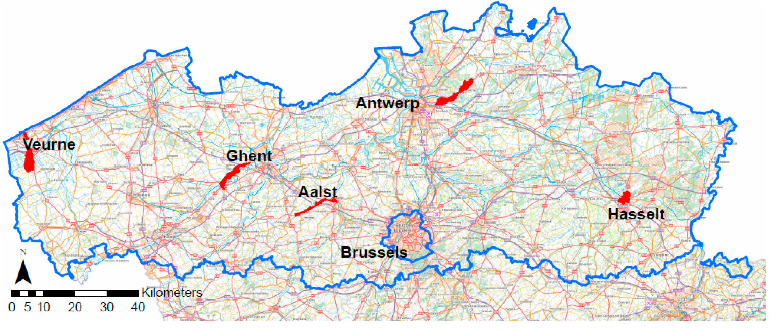
3.1. Context
- Increase the knowledge of the factual land use for economic activities as an input for a future observatory on economic space;
- Analyze the relevant concepts in the Spatial Policy Plan Flanders (BRV) by applying them in common economic contexts.
3.2. Approach and Methodology
4. Results
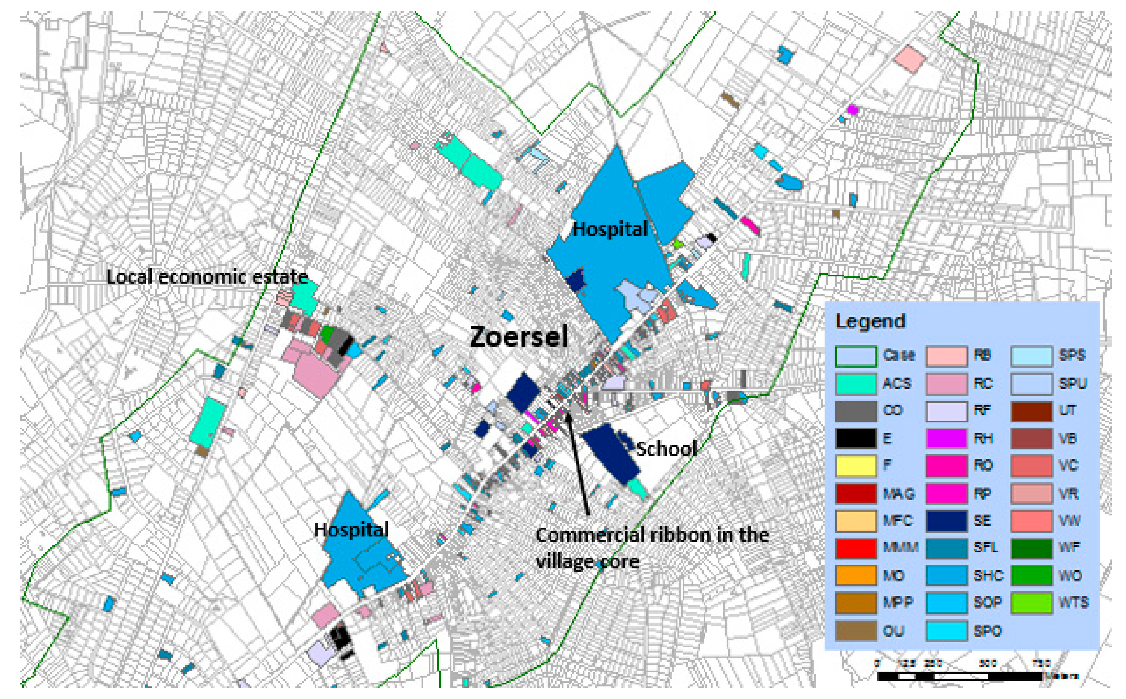
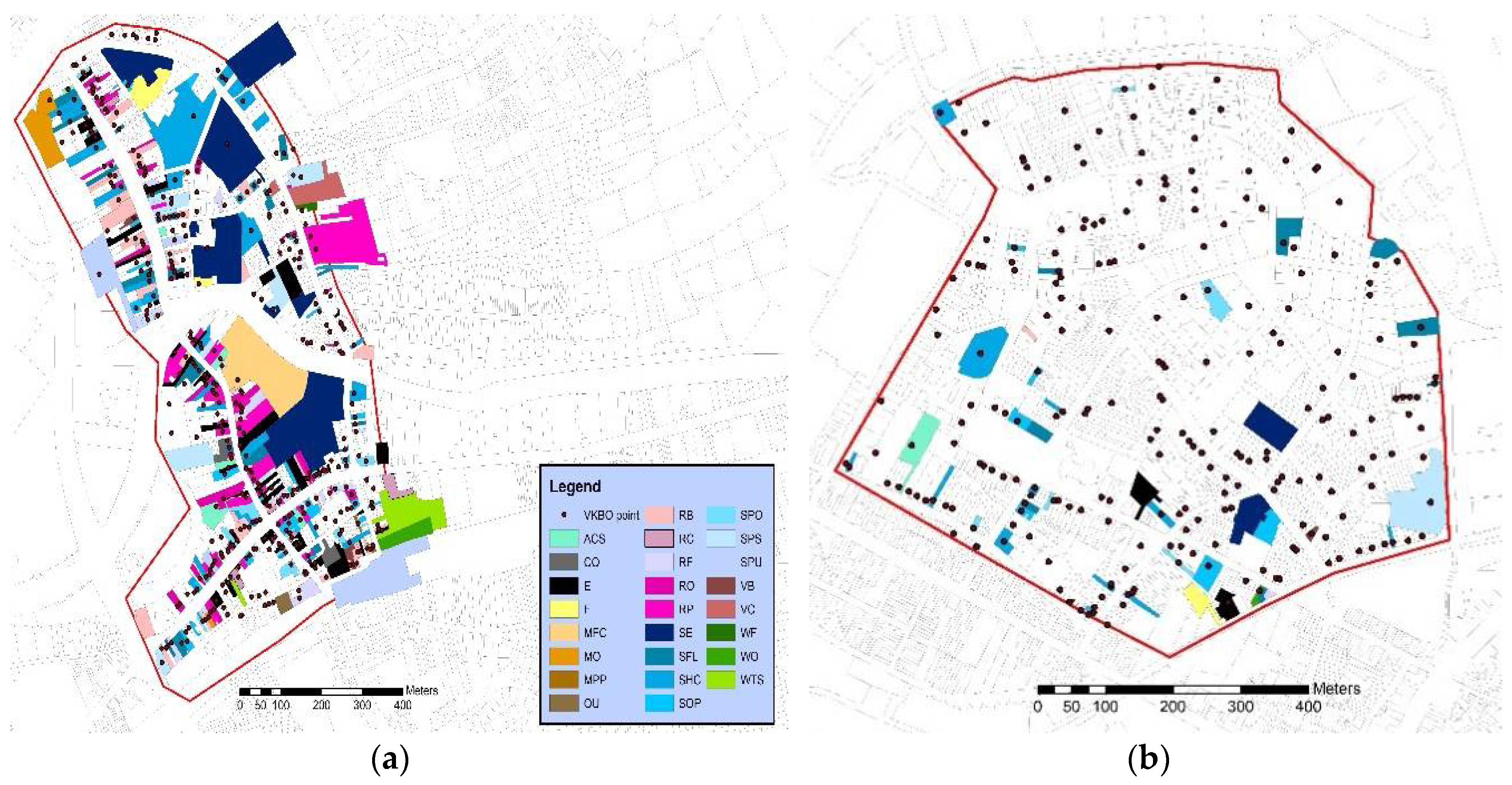
4.1. Inventory and Identification of Location Environments
4.2. The Combination of Field Observations with Different Data and Statistics: Gaps and Analysis
5. Discussion and Conclusions
Author Contributions
Funding
Conflicts of Interest
References
- BIO by Deloitte, Institute for Environmental Studies, Amec, Vienna University of Economics and Business. Study Supporting Potential Land Targets under the 2014 Land Communication; Report Prepared for the European Commission, Directorate-General for Environment; Publications Office of the European Union: Luxembourg, 2014. [Google Scholar] [CrossRef]
- European Commission. Roadmap to a Resource Efficient Europe; COM(2011) 571 Final; European Commission: Brussels, Belgium, 2011. [Google Scholar]
- Flemish Government. Vlaanderen in Cijfers 16; Studiedienst (Studies Office); Flemish Government: Brussels, Belgium, 2016.
- Sarzynski, A.; Galster, G.; Stack, L. Typologies of sprawl: investigating United States metropolitan land use patterns. Urban Geogr. 2014, 35, 48–70. [Google Scholar] [CrossRef]
- Poelmans, L.; Engelen, G. Verklarende Factoren in de Evolutie van Het Ruimtebeslag; Report Commissioned by the Flemish Department Environment (Omgeving—Ruimte Vlaanderen); Ruimte Vlaanderen: Brussels, Belgium, 2014. [Google Scholar]
- Louw, E.; Van der Krabben, E.; Van Amsterdam, H. The Spatial Productivity of Industrial Land. Reg. Stud. 2011, 46, 137–147. [Google Scholar] [CrossRef] [Green Version]
- Hubacek, K.; Van den Bergh, J.C.J.M. Changing concepts of ‘land’in economic theory: From single to multi-disciplinary approaches. Ecol. Econ. 2005, 56, 5–27. [Google Scholar] [CrossRef]
- Van der Krabben, E.; Pen, C.J.; De Feijter, F. De Markt Voor Bedrijventerreinen; Platform 31: The Hague, The Netherlands, 2015. [Google Scholar]
- Vlaamse Regering (Flemish Government). Witboek BRV. Samen aan de Slag om Vlaanderen te Transformeren—Een Opstap naar een Volwaardig Omgevingsbeleid; VR 2016 3011 DOC.0852/2QUINQUIES; Departement Ruimte Vlaanderen (Environment) (Vlaamse Regering- Flemish Government): Brussels, Belgium, 2016.
- Bernett, J. Smart Growth in a Changing World, 2nd ed.; Routledge: Milting Park, UK; New York, NY, USA, 2017; ISBN 9781932364361 (pbk). [Google Scholar]
- Nielsen, E.S. Sprawl and Smart Growth. In Smart Growth Entrepreneurs, 1st ed.; Nielsen, E.S., Ed.; Palgrave Macmillan: Cham, Switzerland, 2017; pp. 35–56. [Google Scholar]
- Dieleman, F.; Wegener, M. Compact City and Urban Sprawl. Built Environ. 2004, 30, 308–323. [Google Scholar] [CrossRef]
- EEA. Urban Sprawl in Europe; Joint EEA-FOEN Report; European Environment Agency: Copenhagen, Denmark; Swiss Federal Office for the Environment: Bern, Switzerland, 2016. [Google Scholar]
- PBL: Netherlands Environmental Assessment Agency. De Compacte Stad Wordt Steeds Groter. Available online: http://www.pbl.nl/nieuws/nieuwsberichten/2011/De-compacte-stad-wordt-steeds-groter (accessed on 24 June 2018).
- Loris, I.; Pisman, A. From migration to urban sprawl in Flanders (Belgium). In Proceedings of the 22nd International Conference on Urban Planning and Regional Development in the Information Society, Vienna, Austria, 12–14 September 2017; pp. 209–217. [Google Scholar]
- De Decker, P. Understanding housing sprawl: the case of Flanders, Belgium. Environ. Plan. 2011, 43, 1634–1654. [Google Scholar] [CrossRef]
- Bervoets, W.; van de Weijer, M.; Vanneste, D.; Vanderstraeten, L.; Ryckewaert, M.; Heynen, H. Towards a sustainable transformation of the detached houses in peri-urban Flanders, Belgium. J. Urban. Int. Res. Placemak. Urban Sustain. 2015, 8, 302–330. [Google Scholar] [CrossRef]
- Vloebergh, G. Studie Segmentatie van Werklocaties: Aanbevelingen Instrumentarium Ruimte Vlaanderen; Omgeving Urbanism commisioned by Ruimte Vlaanderen; Departement Omgeving (Environment Departement Flanders): Brussels, Belgium, 2016. [Google Scholar]
- Vreeker, R.; De Groot, H.L.F.; Verhoef, E.T. Urban Multifunctional Land Use: Theoretical and Empirical Insights on Economies of Scale, Scope and Diversity. Built Environ. 2004, 30, 289–307. [Google Scholar] [CrossRef] [Green Version]
- Dübner, S.; Esper, L.; Stroh, F. City of the Future Constance: “Future City”—Quality instead of Square Meter. In Proceedings of the REAL CORP 2018 Expanding Cities—Diminishing Space, Wien, Austria, 4–6 April 2018; Schrenk, M., Popovisch, V.V., Zeile, P., Elisei, P., Beyer, C., Navratil, G., Eds.; CORP: Wien, Austria, 2018; pp. 135–140, ISBN 978-3-9504173-5-7. [Google Scholar]
- Harbers, A.; Pols, L. Menging van wonen en werken. Ruimte en Maatschappij 2010, 2, 52–65. [Google Scholar]
- Onstein, A.T.C.; Tavasszy, L.A.; Van Damme, D.A. Factors determining distribution structure decision in logistics: A literature review and research agenda. Transp. Rev. 2018, 1–18. [Google Scholar] [CrossRef]
- Rodenburg, C.A.; Nijkamp, P. Multifunctional Land Use in the City: A Typological Overview. Built Environ. 2004, 30, 274–288. [Google Scholar] [CrossRef]
- Allaert, G.; Leinfelder, H.; Dieleman, S.; Pisman, A.; Verhoestraete, E.; Nulens, G.; Schepers, A.; Haentjes, G.; Van Acker, B. Diversiteit in Vormen en Voorkomen van Verweving in Vlaanderen; Report Prepared for Departement Ruimtelijke Ordening, Woonbeleid en Onroerend Erfgoed—Ruimtelijke Planning; Universiteit Gent, Resource Analysis NV & Technum NV: Brussels/Ghent, Belgium, 2007. [Google Scholar]
- Leinfelder, H.; Pisman, A. A methodological framework for a poltical approach of mixed land use, tested in the urbanized region of Flanders, Belgium. In Proceedings of the 4th Joint ACSP-AESOP—Congress Bridging the Divide: Celebrating the City, Chicago, IL, USA, 6–11 July 2008. [Google Scholar]
- Sarzynski, A.; Levy, A. Spatial Efficiency and Regional Prosperity: A Literature Review and Policy Discussion; Prepared as Background for GWIPP’s “Implementing Regionalism” Project, Funded by the Surdna Foundation; George Washington Institute of Public Policy: Washington, DC, USA, 2010. [Google Scholar]
- Vermeiren, K.; Poelmans, L.; Engelen, G.; Loris, I.; Pisman, A. What is Urban Sprawl in Flanders? In Proceedings of the REAL CORP 2018 Expanding Cities—Diminishing Space, Wien, Austria, 4–6 April 2018; Schrenk, M., Popovisch, V.V., Zeile, P., Elisei, P., Beyer, C., Navratil, G., Eds.; CORP: Wien, Austria, 2018; pp. 537–545, ISBN 978-3-9504173-5-7. [Google Scholar]
- Galster, G.; Hanson, R.; Ratcliffe, M.R.; Wolman, H.; Coleman, S.; Freihage, J. Wrestling Sprawl to the Ground: Defining and measuring an elusive concept. Hous. Policy Debate 2001, 12, 681–717. [Google Scholar] [CrossRef]
- Triantakonstantis, D.; Stathakis, D. Examing urban sprawl in Europe using spatial metrics. Geocarto Int. 2015, 30, 1092–1112. [Google Scholar] [CrossRef]
- Bhatta, B.; Saraswat, S.; Bandyopadhyay, D. Urban Sprawl measurement from remote sensing data. Appl. Geogr. 2010, 30, 731–740. [Google Scholar] [CrossRef]
- Herold, M.; Goldstein, N.C.; Clarke, K.C. The spatiotemporal form of urban growth: measurement, analysis and modeling. Remote Sens. Environ. 2003, 86, 286–302. [Google Scholar] [CrossRef]
- Barros, D.L.; Gianotti, M.A.; Larocca, A.P.C.; Quintanilha, J.A. Urban land use pattern identification using variogram on image. Inst. Civ. Eng. Urban Des. Plan. 2016, 169, 56–65. [Google Scholar] [CrossRef]
- Melchiorri, M.; Florczyk, A.J.; Freire, S.; Ehrlich, D.; Schiavina, M.; Pesaresi, M.; Kemper, T. Megacities Spatiotemporal Dynamics Monitored with the Global Human Settlement Layer. In Proceedings of the REAL CORP 2018 Expanding Cities—Diminishing Space, Wien, Austria, 4–6 April 2018; Schrenk, M., Popovisch, V.V., Zeile, P., Elisei, P., Beyer, C., Navratil, G., Eds.; CORP: Wien, Austria, 2018; pp. 285–294, ISBN 978-3-9504173-5-7. [Google Scholar]
- Van Dinteren, J.; Muskens, B.; Geudens, G.; Haskoning, D.H.V. Segmentatie van Werklocaties Vlaanderen; Report Commissioned by Ruimte Vlaanderen; Departement Omgeving (Environment Department Flanders): Brussels, Belgium, 2015. [Google Scholar]
- Van Dinteren, J.; Muskens, B.; Geudens, G.; Zaman, J.; Pennincx, I. Segmentatie van werklocaties. Gezond voor ruimte en economie. Ruimte 2015, 6, 44–49. [Google Scholar]
- Pennincx, I.; De Mulder, S.; Zaman, J. Segmentatie van werklocaties toegepast op verschillende uitgangssituaties. In Verruimen. Ruimte Maken Met Maatschappelijk Talent; Van der Lecq, R., Vanempten, E., Eds.; Stichting Planologische Discussiedagen: Tilburg, The Netherlands, 2016; p. 464. ISBN 9789081921732 9081921738. [Google Scholar]
- Giaratta, F.; Zaman, J. Can an economic activities inventory fill the knowledge gap about the economic sector in a policy making process? In Proceedings of the REAL CORP 2017 Phanta Rei A World in Constant Motion, Wien, Austria, 12–14 September 2017; Schrenk, M., Popovisch, V.V., Zeile, P., Elisei, P., Beyer, C., Eds.; CORP: Wien, Austria, 2017; pp. 77–86, ISBN 978-3-9504173-2-6. [Google Scholar]
- Flemish Government—Verrijkte Kruispuntbank Ondernemingen. Available online: https://overheid.vlaanderen.be/magda-bron/vkbo (accessed on 26 June 2018).
- Locatus. Available online: https://locatus.com/en/ (accessed on 26 June 2018).


| Case | Number of Activities | Number of Firms | Number of Parcels with an Economic Land Use (Percentage of Total Parcels in Study Area) |
|---|---|---|---|
| Koksijde-Veurne | 1235 | 1054 | 945 (14.2%) |
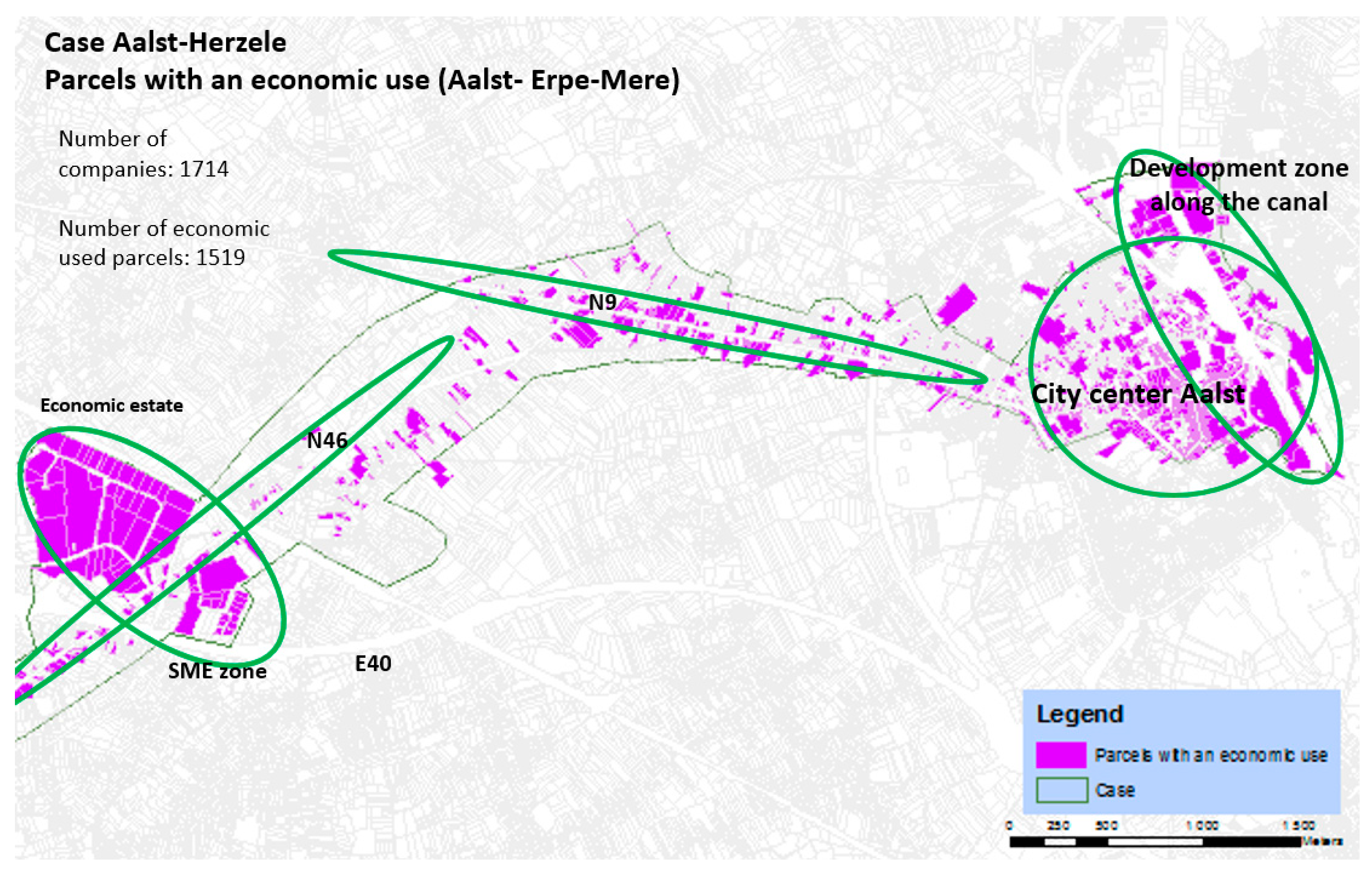
| Aalst-Herzele | 2194 | 1714 | 1519 (15.2%) |
| Hasselt | 2680 | 2187 | 1686 (21.2%) |
| Deinze-Gent | 1118 | 889 | 788 (11.6%) |
| Wijnegem-Malle | 1263 | 1149 | 983 (7.3%) |
| Total for all | 8490 | 6993 | 5921 (13.2%) |
| Location Environments | Number of Parcels with an Economic Function | Average Size (m2) | Median (m2) | Standard Deviation |
|---|---|---|---|---|
| City/urban center | 2432 | 578 | 196 | 1707 |
| High street retail/core shopping area | 1341 | 330 | 181 | 743 |
| Services along the city belt | 680 | 809 | 253 | 2235 |
| Residential areas characterized by scattered services | 590 | 1579 | 677 | 3349 |
| Access roads characterized by retail and car-related business | 209 | 2136 | 1315 | 2595 |
| Access roads characterized by services, retail and catering | 444 | 1269 | 380 | 3246 |
| Village center characterized by retail and services | 401 | 1327 | 433 | 12,007 |
| Village center characterized by scattered services | 220 | 1770 | 836 | 3223 |
| Open areas | 172 | 7467 | 4598 | 8788 |
| Business parks | 453 | 6518 | 3328 | 10,220 |
| Location Environments | Most Common Econ. Activities 1 | Combined with Housing | Vacancy Rate | Agglomeration Effects 2 | Size of Parcels |
|---|---|---|---|---|---|
| Urban centers | Approx. 50% of all main economic activities in retail and catering | Approx. 50% of all parcels with an economic function. Big differences between cities | ±10% | Concentration of similar economic activities (50% of remaining parcels after adjacency) | Small parcels but a large range. Median of approx. 200 m2 |
| High street retail area (urban commercial centers) | Approx. 50–80% of all main economic activities of activities in retail and catering | Approx. 50% of all parcels with an economic use | ±10% | Large concentr. of similar economic activities, more specifically retail and catering (38% remaining parcels) | Smaller parcels. Median of approx. 180 m2 |
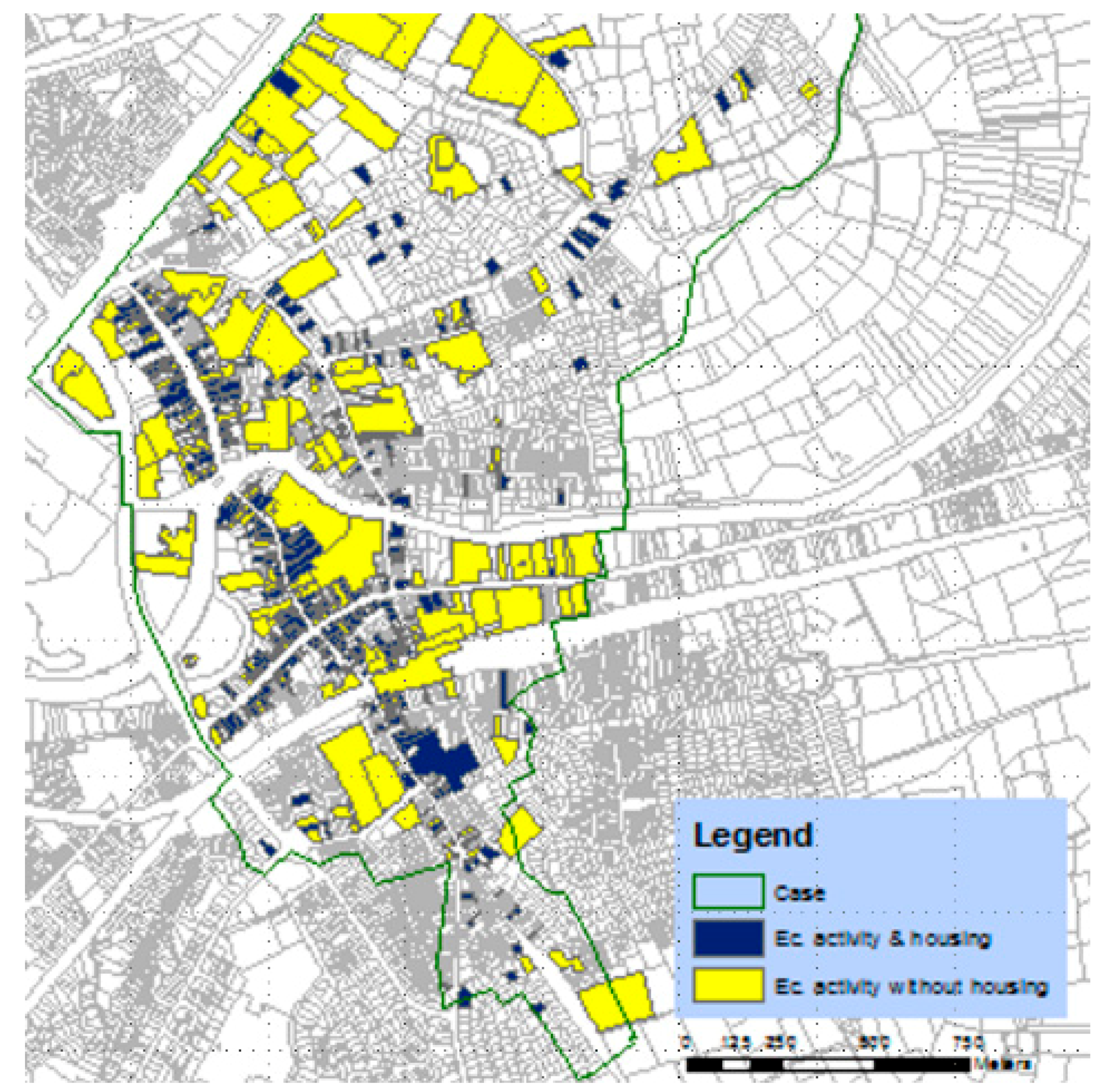
| Services along the city belt | >50% of all main economic activities in services | Approx. two third of all parcels with an economic use is combined with housing. Exceptions: bigger parcels with schools, hospitals | ±10% | Mainly adjacent activities in services (60% remaining parcels) | In general, larger compared to the urban centers. Median of ca. 250 m2. Large range and big differences across areas |
| Residential areas characterized by scattered services | Approx. 2/3 of all main economic activities in services | Approx. 75% of all parcels with an economic function | ±4% | No concentration; adjacent functions (88% remaining parcels) | Large parcels and range. Median of approx. 680 m2 |
| Access roads4 | |||||
| Access roads characterized by retail and car-related business | Economic activities mainly in retail and catering and car-related businesses | Approx. one third of all parcels with an economic function | ±7.5% | Limited (73% remaining parcels) | Large parcels and range. Median of approx. 1315 m2 |
| Access roads characterized by services, retail and catering | Economic activities mainly in retail and catering and services | Approx. 50% of all parcels with an economic function | ±10% | Limited (82% remaining parcels) | Smaller compared to main arterial roads in general. Median of approx. 380 m2 |
| Smaller centers5 | |||||
| (Village) center characterized by retail and services | Economic activities mainly in retail and catering and services | Approx. 80% of all parcels with an economic function | ±6% | Limited concentration of similar economic activities (69% remaining parcels) | Medium sized parcels. Median of approx. 430 m2 |
| (Village) center characterized by scattered services | Approx. 50% of economic activities in services and 25% in retail and catering | Approx. two thirds of all parcels with an economic function | ±4% | Limited (78% of remaining parcels) | Larger parcels and a large range. Median of approx. 830 m2 |
| Open areas3 | Mainly agriculture | Approx. 75% of all parcels with an economic function | <1% | n.a. | Very large parcels and a large range. Median of ca. 4600 m2 |
| Business Parks/economic estates | Wholesale and logistics (ca. 25%), services, production, retail and construction | Approx. 100% of all parcels with an economic function | ±8% | Large (but not uniform across milieu, especially for activities in production/manufacturing (75% of remaining parcels) | Very large parcels. Median of approx. 3260 m2 |
| Location Environment/Milieu | % Companies Detected (Numbers) | % Parcels Detected (Numbers) | % Parcels in the Inventory and in VKBO | % Parcel Detected but Not in VKBO |
|---|---|---|---|---|
| City centers | 61% | 103% | 77% | 25% |
| Core shopping centers | 71% | 125% | 93% | 26% |
| Services along the city belt | 61% | 94% | 68% | 28% |
| Residential areas | 21% | 26% | 17% | 35% |
| Access roads (combined) | 50% | 78% | 55% | 29% |
| Village centers (combined) | 56% | 81% | 58% | 28% |
| Open areas | 56% | 82% | 48% | 42% |
| Economic estates (business parks) | 67% | 121% | 77% | 36% |
| Total | 45% | 66% | 47% | 29% |
© 2018 by the authors. Licensee MDPI, Basel, Switzerland. This article is an open access article distributed under the terms and conditions of the Creative Commons Attribution (CC BY) license (http://creativecommons.org/licenses/by/4.0/).
Share and Cite
Gruijthuijsen, W.; Steenberghen, T.; Vanneste, D.; Zaman, J.; Pennincx, I.; De Mulder, S.; Vermoesen, K.; Horemans, E. Assessing Discrepancies between Official Economic Statistics and Land Use through a Field Inventory System. Infrastructures 2018, 3, 27. https://doi.org/10.3390/infrastructures3030027
Gruijthuijsen W, Steenberghen T, Vanneste D, Zaman J, Pennincx I, De Mulder S, Vermoesen K, Horemans E. Assessing Discrepancies between Official Economic Statistics and Land Use through a Field Inventory System. Infrastructures. 2018; 3(3):27. https://doi.org/10.3390/infrastructures3030027
Chicago/Turabian StyleGruijthuijsen, Wesley, Thérèse Steenberghen, Dominique Vanneste, Jan Zaman, Inge Pennincx, Sophie De Mulder, Koen Vermoesen, and Eline Horemans. 2018. "Assessing Discrepancies between Official Economic Statistics and Land Use through a Field Inventory System" Infrastructures 3, no. 3: 27. https://doi.org/10.3390/infrastructures3030027
APA StyleGruijthuijsen, W., Steenberghen, T., Vanneste, D., Zaman, J., Pennincx, I., De Mulder, S., Vermoesen, K., & Horemans, E. (2018). Assessing Discrepancies between Official Economic Statistics and Land Use through a Field Inventory System. Infrastructures, 3(3), 27. https://doi.org/10.3390/infrastructures3030027