
The Potential Role of Railway Stations and Public Transport Nodes in the Development of “15-Minute Cities”


Institute of Infrastructure, Transport and Mobility, SGH Warsaw School of Economics, 02-554 Warsaw, Poland
Infrastructures 2023, 8(10), 141; https://doi.org/10.3390/infrastructures8100141
Submission received: 4 September 2023
/
Revised: 26 September 2023
/
Accepted: 28 September 2023
/
Published: 5 October 2023
(This article belongs to the Special Issue Railway in the City (RiC))
Abstract
:In 2016, Carlos Moreno proposed the concept of “15-minute cities” based on the principles of proximity, diversity, density, and ubiquity. In fact, he re-formulated (“re-invented”) some of the already existing planning principles, making them recognized and desired by non-professionals. Moreno, however, paid little attention to the external connectivity of neighborhoods, assuming that most needs would be satisfied locally. This paper aims to discuss the concept of “15-minute cities” from the transport planning point of view and investigate how the concept can contribute to such planning. The research review conducted in this paper suggests that similar actions in the past caused a modal shift from the use of cars to public transport, rather than a radical limitation of total transport needs. To simplify, if a neighborhood is well designed, people are more likely to walk, ride a bike, and use public transport, but the majority will still commute outside of the neighborhood for work. In the metropolis of the ideal “15-minute city”, Barcelona, the majority of the inhabitants travel to work either by car or public transport, which proves that they need to move outside the neighborhood. This leads us to the conclusions that (1) “15-minute cities” should incorporate the transit-oriented development concept and include public transport nodes, such as railways or underground stations, as the central point of walkable, multifunctional neighborhoods, and (2) railway/underground station planners should pay more attention to the creation of a proper mix of services at and around the stations according to “15-minute cities” principles. In the future, there should also be more emphasis on re-allocating workplaces to neighborhoods, as well as on researching the actual impact of the (improved and current) “15-minute cities” design on transport volumes.
1. Introduction
The concept of “15-minute cities” is a common and globally recognized idea centered around developing multifunctional, walkable neighborhoods that offer a full range of daily services. Proposed by Carlos Moreno in 2016 [1], it has raised social expectations and the enthusiasm of politicians for (but also some skepticism towards) compact, human-oriented urban planning.
For transport planners, this concept is very promising as shortening trips through appropriate spatial planning can be one of the measures taken to reduce transport demand in congested locations and make transport networks more efficient. Shorter trips may also potentially increase the probability of choosing public transport and non-motorized transport means.
However, the relationship between “15-minute cities” and transport planning remains unclear. Moreno seems to omit the external connectivity of the neighborhoods, probably assuming that it may be fully replaced by the local satisfaction of needs. Finally, a research gap exists concerning the effectiveness of “15-minute cities”. Questions remain as to whether they are truly effective—especially, whether they really lead to shortened daily commutes—and under what circumstances they may be so.
This paper aims to discuss the concept of “15-minute cities” from the perspective of transport systems and investigate how it might contribute to transport planning, with a focus on railway stations and other public transport nodes. We review the current knowledge about “15-minute cities” and their potential impact on the transport system, including on demand for transport.
In the second section, a detailed overview of the “15-minute cities” concept is presented, i.e., how it has been developed by Moreno and other authors. In the third section, some previous concepts are analyzed that are similar to “15-minute cities” in promoting compact, multifunctional urban planning but have been better researched over time. In the fourth section, the potential impact of “15-minute cities” on transport systems is discussed based on a literature review of the effectiveness of similar concepts. In the fifth section, we explore the literature that considers interactions between public transport infrastructure planning and “15-minute cities”.
The analysis in the discussion contributes to the “15-minute cities” idea and transport planning by proposing the appropriate consideration of transport networks in multifunctional neighborhood planning. The discussion also shows the importance of considering multifunctional planning in the design of railway stations and urban transport nodes.
In the last section, possible directions for future research are outlined.
This paper represents the first reflection on the possible effectiveness of the “15-minute cities”, which will identify existing knowledge gaps and research needs.
2. “15-Minute Cities”
The concept of “15-minute cities” was proposed initially by Carlos Moreno in a popular French economic weekly newspaper, La Tribune [1]. In his first manifesto, Moreno began considering the challenges of increasing urbanization (a need to create 1 billion housing units within 10 years) and climate changes. The proposed solution has been called “hyper-proximity” and “chrono-urbanism”. The concept is that, in less than 15 min, an inhabitant should be able to access all his/her basic needs of life. This means bringing the supply closer to the demand. Moreno based his concept on four pillars: proximity, diversity, density, and ubiquity. No particular needs or services were stated by Moreno, but he mentioned that optimization should be achieved using digital technology as well as collaborative and sharing models. In terms of transport, Moreno’s initial concept was described as a “new generation public modality” available 24/7, such as buses on demand, as well as multimodal and shared services. Moreno exemplified his concept by discussing the already existing Barcelona and Tokyo hyperblocks, while using the term “re-inventing proximity” to show that this concept is not something new.
The idea of “15-minute cities” gained popularity worldwide because of its catchy name and simple presentation. Most importantly, the 2020 Paris mayoral campaign saw the idea was used by Anne Hidalgo, who was successfully re-elected and emphasized her sustainable mobility priorities.
Later, Moreno et al. [2] published a much more detailed paper in the scientific journal Sustainability, presenting their ideas in the context of post-pandemic needs. The paper presented a list of functions required in a 15-minute-city neighborhood: living, working, commerce, healthcare, education, and entertainment. The authors also replace “ubiquity” with “digitalization” as one of the four pillars of the “modified 15-minute city”, besides density, diversity, and proximity. They also mention that 15-minute access can be achieved by providing temporal and spatial proximity, especially within the 15-minute-accessible radial nodes. In their conclusions, they state that the value of 15 min is not rigid, but aims to represent proximity as the basis of the concept. Still, they place little emphasis on public transport, especially railways, focusing mostly on walking and biking.
Some other authors have also contributed to the concept of “15-minute cities”, discussing their ideas with Moreno.
Duany, who has been dealing with compact urban planning for decades, and Seuteville [3] concluded that “the 15-minute city is a simple enough concept that it resonates with a wide range of people”, especially mentioning decision makers such as Paris mayor Anne Hildago and unsuccessful New York mayoral candidate Shaun Donovan.
They also defined three shed levels; a 5 min walk to small businesses (ca. 2600 inhabitants); a 15 min walk to a full mix of services and amenities, including larger parks and employers, shops, and schools (ca. 23,000 inhabitants); and a 15 min bike ride to major cultural, medical, and higher education facilities (ca. 350,000 inhabitants). They stressed that such planning is something that “new urbanists always focused on”.
Khavarian-Garmsir et al. [4] have extended the list provided by Moreno and defined the following seven pillars of the “15-minute city”: human scale, density, diversity, flexibility, proximity, digitalization, and connectivity. They also emphasized that the idea should lead to social, economic, and environmental sustainability.
Pozoukidou and Chatziyiannaki [5] concluded that the “15-minute cities” concept implies a conceptual switch from accessibility to proximity. The focus is no longer on moving people to services but bringing services closer to the people. They have stated that “15-minute cities” are not a radical idea, but neither are they “fit-for-all”. They need to be based on the unique forms and structures of a given city, combined with additional proven planning principles.
3. Alternative Concepts (3D, Compact City, TOD)
Moreno’s idea included several prior concepts, some of which were quoted by Moreno himself. Kissfazekaz [6] noticed that the concept of “15-minute cities” is, in fact, a development of the 100-year-old concept of the neighborhood unit, especially popular in Europe. Geenhalgh [7] discussed the British example of the neighborhood unit. This approach has been used since 1944, and Pozokidou and Chatziyiannaki [5] concluded that the concept uses “long established planning principles” to provide attractive neighborhoods.
Surprisingly, Moreno et al. referred primarily not to European, but to American authors, such as Jacobs [8], Alexander [9], and Duany and Plater-Zyberk [10]. Since the 1960s, these authors have promoted walkable, pedestrian-friendly urban environments, as opposed to the traditional car-oriented American suburban sprawl, which is rare in Europe.
In particular, Moreno et al. [2] referred to Cervero and Kockelman [11] as examples of researchers that have designated density as the “crucial dimension of the city”. In fact, Cervero and Kockelman’s paper developed a much more complex idea of the 3Ds—density, diversity, and design—as providing bases for urban planning, referring to contemporary design philosophies, such as new urbanism, transit-oriented development, and traditional town planning. They also tested its effectiveness, which will be referred to in the following section.
Moreno et al. also quoted the idea of the compact city promoted by Salingaros [12], especially the idea that “all the essentials” need to be accessible without a car. In the paper in question, Sailingaros proposed the concept of “the third way”, developing community structures that lie between suburban sprawl and ultra-high-density cities and coming back to the traditional idea of the small town by re-writing traditional urban zoning rules and increasing mixed-use planning.
Moreno et al. have not quoted or referred to the concept of transit-oriented development (TOD). This concept has been presented comprehensively by Ibraeva et. al. [13].
TOD was introduced in the 1990s by Calthorpe [14], but it had been inspired by much earlier ideas, such as, for example, the garden city proposed in 1902 by Howard [15]. The concept assumed mixed-use areas located within ca. 500 m walking distance around a core comprising a public transport option (rail, underground station) and a high-density commercial area. The neighborhood would include residential, retail, office, and public spaces. Such an area would be walkable inside, but also accessible from outside by high-quality public transport. The building density would decrease when moving away from the core, and the share of residential area would increase. Hickman and Hall summed up the concept as “careful coordination of urban structure around the public transport network”, [16].
R. Thomas and L. Bertolini [17] identified 16 critical success factors of TOD, including government support, regional-level TOD planning, public participation, public acceptance, and key visionaries. This shows that TOD is not a single, isolated venture of a single entity, but a team endeavor. As shown in the meta-analysis conducted by Moinse [18], the newest studies outline the idea that TOD centers should be complex micromobility hubs in order to extend catchment areas, although this is often missed in the existing research.
The difference between TOD and the “15-minute city” is mostly that in discussing a “15-minute city”, authors have assumed the self-sufficiency of the walkable area and focused little on external connections. Conversely, in TOD we assume that people are moving in and out of the neighborhood, primarily via public transport, using a hub located in the core of the area.
4. Is the “15-Minute City”, in Fact, Effective?
Little evidence exists as to whether the “15-minute city” is as effective as expected. It seems obvious that the proximity of daily services reduces transport needs, and its remoteness and dispersal increases them; therefore, many people trust Moreno’s idea without further evidence.
Still, we should remember that in the case of some needs, we do not choose the nearest opportunity to satisfy them, but rather the most convenient in terms of quality, which may be distant. Therefore, several questions should be asked: How many external journeys are avoided, and how many are retained, due to the introduction of a “15-minute city”? Do people really travel noticeably less, giving external connectivity of the “15-minute city” a secondary role because the vast majority of needs are satisfied locally? Or should we draw more extensively on the TOD concept and put more stress on external connectivity?
Duany and Seuteville [19] stated that the cities of Paris, Buffalo, and Auburn are examples of well-designed “15-minute cities”; Bocca [20] mentioned Paris, Milan, and Melbourne as successful examples; and Papas [21] mentioned Paris, Barcelona, Valencia, Madrid, Milan, Rome, Bologna, and Naples. None of these authors have given evidence of the actual impact justifying the success of the “15-minute city” concept in these cities. Rather, they have given evidence of the measures implemented, and sometimes described the monitoring of these measures.
Some empirical impact research has been conducted by Weng et al. [22], who researched the impact of the walkability of different parts of Shanghai on social inequalities. Their findings were influenced by the fact that walkable neighborhoods were located in central areas, and less walkable ones were located in peripheral areas. This clearly indicated that, for example, there were more senior and adult people in walkable areas, and the authors concluded that walkable neighborhoods have a higher share of a floating population (nonresidents). They did not address the problem of reducing transport needs.
Complex research has been conducted by Ferrer-Ortiz et al. [23] in Barcelona. They analyzed service availability in different parts of the city and concluded that “the city as a whole and its composing neighborhoods” meet the criteria of a “15-minute city”. Their methodological approach was based on measuring the range of services present in a given neighborhood, including care, education, provision, entertainment, and transport (with a high stress on biking), but excluding workplaces.
Like many others, this study focused on quantifying the measures undertaken, rather than the impact. The authors did not even attempt to find out how meeting the 15 min criteria influenced travel patterns.
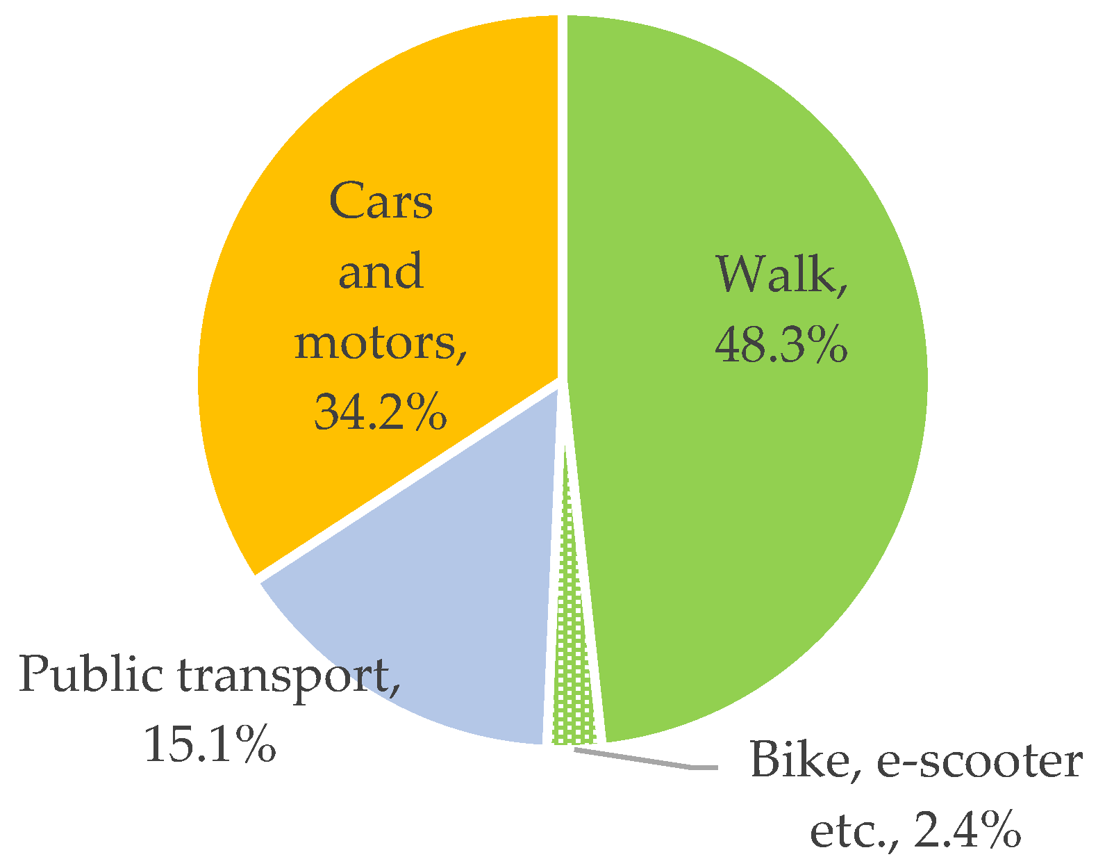
According to the 2022 post-pandemic traffic survey conducted by the metropolitan authority of Barcelona [24], the area of Barcelona indeed has a high share of walking trips (48.3%), but also a high dominance of car trips (34.2%) over public transport trips (15.1%), as can be seen in Figure 1.
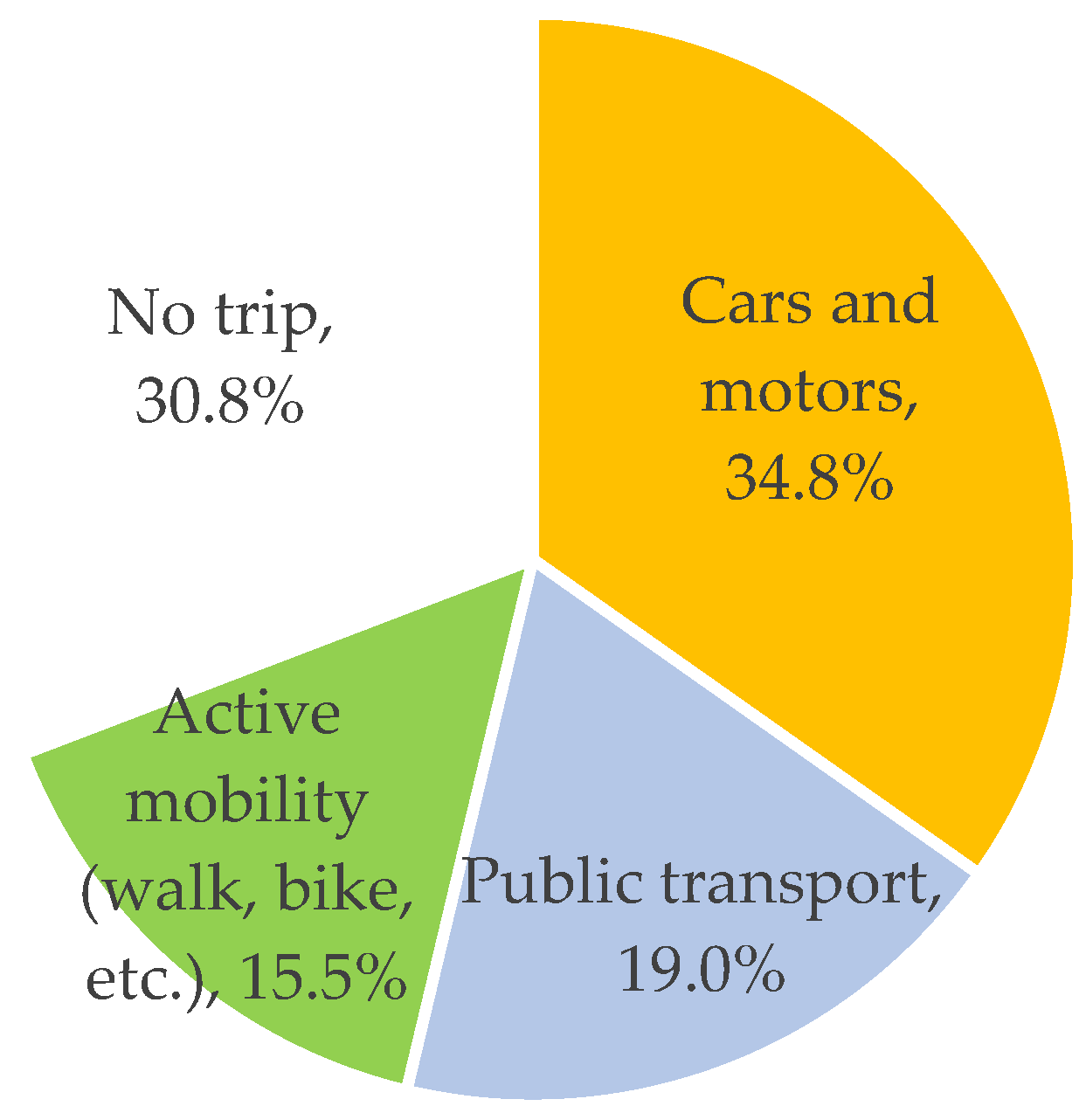
Still, in the case of trips to work/school, the share of car trips accounted for 50%, walking/biking for about 22%, and public transport for the remaining 28%. In total, the 4.8 million inhabitants over 16 years old analyzed in the survey generated 2.9 million trips to work and 0.5 million trips to school in a representative workday (return trips were considered separately and their number slightly differed because of round trips); therefore, only 30.8% of the population did not generate any trips, meaning they either worked from home or were not employed (including being unemployed and retired) (see Figure 2). The remaining ca. 70% traveled to work or school. This means that working from home was not very popular. Based on the survey, we can also calculate that ca. 35% of the total population traveled to work/school by car and ca. 29% by public transport. In total, over 50% of the surveyed 16+ population traveled to work/school by a motorized means of transport, which probably took them outside their neighborhood (otherwise, they would have walked/biked as did the remaining ca. 15.5% or “stayed at home” as did 31%).
This cannot be interpreted as evidence for the ineffectiveness of “15-minute cities” for several reasons. Firstly, the quoted travel survey data are for the entire metropolitan area, and Ferrer-Ortiz et al. have only analyzed the city of Barcelona. Secondly, this is only a static analysis of the situation, not a dynamic one comparing the situations before and after introducing the concept. Thirdly, the availability of workplaces has not been included in the indicator by Ferrer-Ortiz; therefore, his conclusion that Barcelona is an ideal “15-minute city” may be premature, although the city has been appreciated by Moreno from the very beginning for its superblocks.
Considering the Barcelona traffic survey, we are not entitled to assume that the majority of people will genuinely stop commuting to work or school outside the neighborhood in an area that we currently call a well-designed “15-minute city”.
More studies exist about the effectiveness of the previous concepts that were similar to the “15-minute cities” idea.
Cervero and Kockelman [11] hypothesized that high density, mixed land use, and pedestrian-friendly design reduce the need for car travel. They verified their hypothesis with the example of the San Francisco Bay Area and noted that the concept has a surprisingly low (“modest to moderate at best”) impact on the number of vehicle miles traveled. They found that trips to work were generated at a very similar level that did not depend on the quality of spatial planning. However, they stated that retail shops in the vicinity influenced modal choice for work trips, from which the conclusion can be drawn that, if more spatially dispersed targets are located en route, cars are more likely to be used.
Similar conclusions were drawn by Crane and Chatman [25], who were also surprised by the low relation between decentralization and commuting.
There has also been some research conducted by Ewing and Cervero [26] and Ibraeva [13] on the effectiveness of the TOD concept regarding the coordination of spatial structures around public transport stations. Most of the research is from America, and the vast majority of the authors focus on the impact on modal split, rather than on the total number or length of the trips.
K. Park et al. [27] concluded that public transport use depended on public transport availability and land use diversity, and walking depended on street network design. Density had a low impact on the modal split.
G. Tian et al. [28] concluded that one of the leading TODs in the US—Redmond in the Seattle Region—generated 1.7 more walking trips and 3 times more public transport trips than expected, calculated according to the Institute of Transportation Engineers’ Trip Generation Manual (ITE TGM). Only around 1/3 of the trips were performed by cars, and parking demand was noticeably lower.
Ewing et al. [29] analyzed five TODs across the US. They described these areas as being designed in a way that “minimizes distance to transit, literally abutting transit stations”. They found that peak parking demand as well as vehicle trip generation rates were usually lower by about 50% in these areas compared to those calculated according to the ITE TGM.
Still, almost all TOD studies meta-analyzed both by Ewing and Cervero [26] and Ibraeva [13] focus on modal split or number of vehicle trips, i.e., on reducing car usage and increasing public transport usage, and not on reducing transport needs, although walking/public transport trips are usually shorter than motorized ones.
The only research that referred to the total distances traveled was a study by Fan [30], which was his doctoral dissertation. The author concluded that transportation demand management programs have limited effectiveness. He found that heavy traffic, a greater number of nearby retail stores, and cold weather limited the time allocated to travel, especially driving. Land use density played a minor role in limiting travel needs. This confirms our previous conclusion drawn from Barcelona.
Finally, constant time travel budget (TTB) theories may influence the actual effectiveness of “15-minute cities”. Often, they are identified with the Marchetti constant [31], a constant time of ca. 1 h that we spend traveling daily and which does not depend on external factors. If we have better infrastructure and travel faster, we cover greater distances in the same amount of time, as opposed to traveling the same distance in less time.
According to those theories, we can expect that when people travel less often to some destinations, because of the “15-minute city”, they start traveling more often to other destinations.
In fact, this is a much more complex and controversial phenomenon.
Mokhtarian and C. Chen [32] conducted a meta-analysis on almost 30 studies and concluded that at the aggregate level, travel time and money budgets “appear to have some stability”. Conversely, at the disaggregate level, they are a function of some variables determining sub-populations (such as income level, gender, car ownership).
Authors researching TTB in London [33], the Netherlands [34], and the USA [35] often note that people living in dense urban areas spend more time traveling. Car ownership influences total time spent traveling, but both positive [36] and negative [37] influence has been observed.
TTB studies do not negate the potential influence of better spatial design on the total mileage traveled, but also show that urban density or no car ownership may increase TTB.
We may conclude that there is no evidence that proper spatial planning—especially introducing the “15-minute city”—causes a revolutionary reduction in transport needs, especially in the case of the work/school commute of people over 16 years old. For now, we should rather assume that, thanks to diversified neighborhoods, we may increase the usage of public transport and active mobility, as well as reduce the number of facultative trips.
5. Public Transport Infrastructure and “15-Minute Cities”
As already mentioned, urban railways, external connections, and the idea of TOD (building compact neighborhoods around public transport nodes) are rarely considered by proponents of “15-minute cities”.
Moreno focused on on-demand services. These may be effective inside a district in the case of low and dispersed traffic but are not effective in the case of high volumes of people moving to CBDs, logistics, and manufacturing districts. This seems to be a result of the already mentioned assumption that inhabitants of the “15-minute city” do not need to go to work or school outside the city.
Duany and Steuteville [3] assumed that commuter transit stops should be located at the periphery of the neighborhood, stating that “two kinds of stations may be incorporated into the 15-minute city—community transit stops [bus, tram], which are primarily accessed through human-powered mobility, and commuter transit stops [rail, tube], which are accessed by car. The community stop should be at the center of the 15-minute city and the commuter stop may go at the edge, perhaps where two 15-minute city areas abut. The transit stations connect the 15-minute city sectors and allow access to transit from more distant locations.” Accessing commuter transit stops by car seems to be an especially controversial approach, which differs from TOD. This solution has an advantage, however, in that railway stations are also accessible by car for people from outside the “15-minute city” without bringing additional traffic into the dense center. In some cities or neighborhoods, this layout may also be justified by the historical location of a station.
Khavarian-Garmsir et al. [4] stated that “active mobility modes like walking and cycling are combined with public transportation, increasing public transportation efficiency, and addressing first/last mile connections”. This means they assume some external and internal accessibility by public transportation, but do not focus on it too much. This remains a noticeable difference from Moreno’s priorities.
Additionally, most of the authors dealing with public transport station design do not focus much on the influence of the location of the “15-minute city”, or even TOD neighborhood functions (such as supermarkets, bistros, sport facilities, kindergartens, or even office/co-working spaces), on the station or its location.
Eboli et al. [38], in their analysis of the quality of railway stations, included security, cleanliness, maintenance, integration with other transport systems, and information at the station, as well as connections with other transport modes. They even defined a category called “additional services”, but these included only “facilities for disabled” rather than additional services for the remaining passengers.
Kruszyna and Makuch [39], when assessing the level of services at different stations, awarded a noticeable number of points for the location, from 0 for “distant” to 10 for “central internal”, but did not directly score for the daily services available at the station. These are usually somehow connected, although even in a “distant” location, some of the neighborhood functions may be located at the station. In his other research, Kruszyna [40] included the number of residents in the target area and parking volume in the park and ride facilities.
More can be found in studies analyzing ridership at different underground or urban rail stations. For example, a study by Zhao et al. [41] found that the ridership at metro stations in Nanjing was determined by 11 variables, including business/office floor area, the CBD dummy variable, and the number of major educational sites, entertainment venues, and shopping centers in the proximity of the station.
Amini Pishro et al. [42] analyzed the ridership at Chengdu rail–transit hubs and developed a very complex model showing the relationship between the location of a station (17 variables) and ridership (8 models representing different times of week and day, as well as in- and out-bound traffic). The multiple linear regression models included all the considered variables; however, the number of public facilities, offices, and shops generally influenced the ridership to the greatest extent.
Son and Shim [43], when analyzing the Seoul metro, noticed that employment, commercial floor area, office floor area, and net population density were four out of seven factors determining the number of boardings at the given station.
Chan and Miranda-Moreno [44] noticed that, in Montreal, metro commercial and governmental land use and population density belonged to the significant determinates of station usage in peak hours. They concluded that dense and diverse land use maximizes metro station ridership.
This shows that intensive urban functions around a public transport station influence ridership but are rarely considered by station planners.
The only author who tried to merge the idea of “15-minute cities”, TOD, and railway station design was Fabio Borghetti, who, with other authors, has published three papers referring to different Italian regions. He called his concept a “15-minute station”. In his papers, he mostly focuses on the measurement of the number of services around the selected railway stations.
In the first paper, Borghetti et al. [45] proposed a dimensionless index IS that would show how much a station is integrated into the territorial context. The index is based on the number of accommodation, sports, cultural, educational, financial, healthcare, and market services attainable within three thresholds of accessibility from the station: a 5, 10, and 15 min walk. The index was estimated for four different stations (Milano Porta Vittoria, Gallarate, Desenzano del Garda, and Monza) using GIS tools. The author concluded that, in the future, different services may have different weights.
In the second paper, Borghetti et al. [46] listed a much longer range of services (12 categories, including libraries, pubs, and pharmacies, but excluding offices and accommodation), and studied their presence around 11 stations. The index had top value for the Milano Lambrate and Monza stations. In the discussion, the authors stated that most of the “15-minute city” concepts were carried out in non-standard areas of the cities and without a unique and clear vision. He suggested that railway stations and 15 min walk areas around the stations may create optimal “15-minute cities”. Some services could be located even directly at the railway stations. This may also shift some of the traffic onto railways, reducing emissions and energy consumption.
In the third paper, Fazio and Borghetti et al. [47] again focused on the 15 min accessibility of selected railway stations, this time in the city of Catana, counting and visualizing selected POIs around the stations. They concluded that improving the walkability of the city could improve the number of POIs accessible from the station by 25%.
Unfortunately, Borghetti’s research focused on the measurement of quality of spatial planning, and not on its influence.
6. Discussion
As Duany wrote, Moreno has developed “a simple enough concept that it resonates with a wide range of people” by reframing some of the major assumptions of new urbanism. [3] This is a good lesson for scientists on how to convince the public and decision makers to embrace well-established yet not very catchy ideas and turn theoretical concepts into practical, commonly recognizable, and desirable actions. Even Moreno himself calls the concept “re-inventing proximity”.
Enthusiasm breeds expectations, which may sometimes be excessive. Between the lines, Moreno promises and assumes that commuting to work and school will not be necessary anymore; all destinations will be available within a short walk. This is desirable; however, it has not been proven possible by the researchers whose ideas have underpinned the work. They pointed out that mixed-use neighborhoods cause modal shifts toward public transport and reduce some facultative journeys, but not necessarily reduce trips to work.
The example of Barcelona has proven that a very well assessed “15-minute city” still generates many trips to work, even after the COVID-19 pandemic. Out of the almost 5 million inhabitants of the Barcelona metropolis over the age of 16, 34.8% go to school/work by car, 19% travel by public transport, 30.8% stay at home (this includes working from home and being retired or unemployed), and only 15.5% walk or bike. However, in total, half of the trips are conducted by walking, biking, or other active mobility modes.
Many people still need to commute to a place of work that is located in industrial and logistics zones, as well as central business districts. This cannot be rapidly changed, as high amounts of money have been invested in those facilities, and they may not be easily relocated. At least in the short term, this requires a stronger appreciation of external connections with high-quality public transport as a part of the “15-minute cities” idea.
This leads us to the conclusion that commuting cannot be as easily eliminated as it seemed to Moreno. If it cannot be eliminated, it needs to be managed in order to provide sustainability.
Firstly, the transit-oriented development concept seems to be a solution. The “15-minute cities” idea is a masterpiece of how to talk about diverse, but also dense, spatial planning based on multifunctional neighborhoods. However, some concepts of TOD need to be incorporated into the scheme, and expectations should be adjusted to be more realistic. In fact, TOD is very similar to the “15-minute city” idea; both concepts may complement each other, as they have different priorities but are not contradictive.
The concept of “15-minute cities” should simply be implemented around public transport nodes, which are usually railway stations, underground stations, or tram stops. This ensures comfortable journeys with public transport. Depending on an individual’s needs, when going to work on the way to the station it could be possible to bring their child to kindergarten. Coming back, they could shop, dine, work out at the gym, swim, or visit a doctor. The list of activities is individual to every person; nevertheless, little research has focused on establishing a proper list of amenities.
This does not negate the entire concept of “15-minute cites” but should encourage a higher level of focus on external connections of the neighborhoods.
The concept of “15-minute cities” should also be incorporated by railway network and station managers, including underground station managers. The variety of services around stations should not only be monitored (as Borghetti does) but also stimulated to increase patronage.
Railway network and station managers should aim to provide an appropriate mix of daily services at and around the stations. This may not only attract passengers but also stimulate further urban development in the proximity of re-arranged stations.
Under this concept, redundant land plots belonging to the railway companies could be re-used for the benefit of sustainable land use and mobility.
One of the reasons for the partial ineffectiveness of a “15-minute city” may be the uneven distribution of workplaces between the neighborhoods. The initial manifesto by Moreno included this [1]. However, the research of Ferrer-Ortiz et al. [22] omitted this aspect, focusing on other needs, such as healthcare, shopping, culture, or education. In fact, the majority of inhabitants go to work more often than visit a doctor.
It is extremely challenging to bring jobs closer to residential districts (as seen in the example of Barcelona). Over the last decades, factories, as well as logistics and business centers, have been tended to be located in different neighborhoods than housing—in contrary to the 19th century model of tenements next to factories. In some cases, this was justified by emissions etc.; in other cases, businesses wanted to be in central business districts.
This can be partially changed, but doing so will require time and there have not been many attempts to make this change. There is also a question about the limits of possible dispersion of workplaces between neighborhoods and the willingness of people to choose local jobs. The jobs market is not as homogeneous as grocery markets, and local inhabitants may not work locally. A partial solution to the problem may be the provision of local co-working centers, which may reduce the number of people who do not work from home, but potentially can work remotely.
These strategic land use patterns have probably influenced the quoted research. Many of the studies come from American cities with separate business and residential districts, where mixed-use means “residential with shops”, not a mix between residential and office spaces.
In the long term, the proposed “15-minute city” idea should focus on verifying the hypothesis of possibly shortening total trips and increasing measures that will shorten work trips and disperse workplaces. The question about the limits of dispersing workplaces remains open, and so we should assume that some limits exist.
7. Conclusions
The concepts considered in the paper are summed up in Table 1.
The idea of “15-minute cities”, as proposed by Moreno, belongs to compact urban planning concepts. There is little evidence that compact urban planning noticeably decreases total transport needs, especially in the case of work/school trips of people over 16 years old. It can, however, decrease car usage; therefore, we need to deal properly with the external connectivity of mixed-use, walkable neighborhoods.
In the future, the “15-minute cities” concept should incorporate more from the transit-oriented development concept and include public transport nodes, such as railways or underground stations, as the central points of the walkable, multifunctional neighborhoods. This concept can be called TOD-based “15-minute cities”.
Public transport station managers should pay more attention to the creation of a proper mix of services at and around the stations in accordance with “15-minute cities” principles. This will allow them to obtain the expected modal shift.
In the future, more stress should be place on re-allocating labor places to the neighborhoods (also in proximity to railway or underground stations), although the effectiveness of this should be monitored. In terms of the outcomes, this could bring us closer to the ideal “15-minute cities” that Moreno imagined.
8. Possible Directions for Future Studies
Further research on the actual impact of the (improved and current) “15-minute cities” design on transport volume is needed. Research is currently focused too much on measuring “what has been done?” (quality of planning, quality of local offerings) and not “what results has it brought?”
In particular, we should try to monitor the implementation of “15-minute cities”, taking into account their impact on the total distance traveled, covered distance to work, modal shift of different trips (with particular focus on work trips), reallocation of workplaces to the local neighborhoods, as well as willingness of employees to choose local jobs. Such research should gather reference data before the intentional introduction of the “15-minute cities” concept as modal split and distances of commuting are differentiated between cities for many historical reasons.
The indicators and their dynamics should be compared between Moreno’s “15-minute cities”, TOD-based “15-minute cities”, and “Ideal 15-minute cities” with the workplaces dispersed between neighborhoods.
Funding
This research received no external funding.
Institutional Review Board Statement
Not applicable.
Informed Consent Statement
Not applicable.
Data Availability Statement
Not applicable.
Conflicts of Interest
The author declares no conflict of interest.
References
- Moreno, C. La Ville du Quart D’heure: Pour un Nouveau Chrono-Urbanisme. Available online: https://www.latribune.fr/regions/smart-cities/la-tribune-de-carlos-moreno/la-ville-du-quart-d-heure-pour-un-nouveau-chrono-urbanisme-604358.html (accessed on 11 August 2023).
- Moreno, C.; Allam, Z.; Chabaud, D.; Gall, C.; Pratlong, F. Introducing the “15-Minute City”: Sustainability, Resilience and Place Identity in Future Post-Pandemic Cities. Smart Cities 2021, 4, 93–111. [Google Scholar] [CrossRef]
- Duany, A.; Steuteville, R. Defining the 15-Minute City. Available online: https://www.cnu.org/publicsquare/2021/02/08/defining-15-minute-city (accessed on 11 August 2023).
- Khavarian-Garmsir, A.R.; Sharifi, A.; Sadeghi, A. The 15-minute city: Urban planning and design efforts toward creating sustainable neighborhoods. Cities 2023, 132, 104101. [Google Scholar] [CrossRef]
- Pozoukidou, G.; Chatziyiannaki, Z. 15-Minute City: Decomposing the New Urban Planning Eutopia. Sustainability 2021, 13, 928. [Google Scholar] [CrossRef]
- Kissfazekas, K. Circle of paradigms? Or ‘15-minute’ neighbourhoods from the 1950s. Cities 2022, 123, 103587. [Google Scholar] [CrossRef]
- Greenhalgh, J. Consuming communities: The neighbourhood unit and the role of retail spaces on British housing estates, 1944–1958. Urban Hist. 2016, 43, 158–174. [Google Scholar] [CrossRef]
- Jacobs, J. The Death and Life of Great American Cities; Random House: New York, NY, USA, 1961. [Google Scholar]
- Alexander, C. The Nature of Order: The Process of Creating Life; The Centre for Environmental Structure: Berkeley, CA, USA, 2002. [Google Scholar]
- Duany, A.; Plater-Zyberk, E.; Speck, J. Suburban Nation: The Rise of Sprawl and the Decline of the American Dream; North Point: New York, NY, USA, 2000. [Google Scholar]
- Cervero, R.; Kockelman, K. Travel demand and the 3ds: Density, diversity, and design. Transp. Res. Part D Transp. Environ. 1997, 2, 199–219. [Google Scholar] [CrossRef]
- Salingaros, N.A. Complexity and urban coherence. J. Urban Des. 2000, 5, 291–316. [Google Scholar] [CrossRef]
- Ibraeva, A.; de Almeida Correia, G.H.; Silva, C.; Antunes, A.P. Transit-oriented development: A review of research achievements and challenges. Transp. Res. Part A Policy Pract. 2020, 132, 110–130. [Google Scholar] [CrossRef]
- Calthorpe, P. The Next American Metropolis. Ecology, Community and the American Dream; Princeton Architectural Press: New York, NY, USA, 1993. [Google Scholar]
- Howard, E. Garden Cities of Tomorrow; Swan Sonnenschein: London, UK, 1902. [Google Scholar]
- Hickman, R.; Hall, P. Moving the City East: Explorations into contextual public transport-orientated development. Plan. Pract. Res. 2008, 23, 323–339. [Google Scholar] [CrossRef]
- Thomas, R.; Bertolini, L. Defining critical success factors in TOD implementation using rough set analysis. J. Transp. Land Use 2015, 10, 139–154. [Google Scholar] [CrossRef]
- Duany, A.; Steuteville, R. From Slogan to Substance, Planning the 15-Minute City. Available online: https://www.cnu.org/publicsquare/2022/12/13/slogan-substance-planning-15-minute-city (accessed on 11 August 2023).
- Moinse, D. A Systematic Literature Review on Station Area Integrating Micromobility in Europe: A 21st Century Transit-Oriented Development. Available online: https://shs.hal.science/halshs-03857389/document (accessed on 21 September 2023).
- Bocca, A. Public space and 15-minute city. TeMA-J. Land Use Mobil. Environ. 2020, 14, 395–410. [Google Scholar]
- Papas, T.; Basbas, S.; Campisi, T. Urban mobility evolution and the 15-minute city model: From holistic to bottom-up approach. Transp. Res. Procedia 2023, 69, 544–551. [Google Scholar] [CrossRef]
- Weng, M.; Ding, N.; Li, J.; Jin, X.; Xiao, H.; He, Z.; Su, S. The 15-minute walkable neighborhoods: Measurement, social inequalities and implications for building healthy communities in urban China. J. Transp. Health 2019, 13, 259–273. [Google Scholar] [CrossRef]
- Ferrer-Ortiz, C.; Marquet, O.; Mojica, L.; Vich, G. Barcelona under the 15-Minute City Lens: Mapping the Accessibility and Proximity Potential Based on Pedestrian Travel Times. Smart Cities 2022, 5, 146–161. [Google Scholar] [CrossRef]
- Enquesta de Mobilitat en Dia Feiner 2022 (EMEF 2022). Fulletó Principals Resultats. Available online: https://www.omc.cat/documents/662112/1182871/EMEF+2022_Fullet%C3%B3.pdf (accessed on 11 August 2023).
- Crane, R.; Chatman, D.G. Traffic and sprawl: Evidence from US commuting 1985 to 1997. Plan. Mark. 2003, 6, 14–22. [Google Scholar]
- Ewing, R.; Cervero, R. Travel and the built environment: A meta-analysis. J. Am. Plan. Assoc. 2010, 76, 265–294. [Google Scholar] [CrossRef]
- Park, K.; Ewing, R.; Scheer, B.C.; Tian, G. The impacts of built environment characteristics of rail station areas on household travel behavior. Cities 2018, 74, 277–283. [Google Scholar] [CrossRef]
- Tian, G.; Ewing, R.; Weinberger, R.; Shively, K.; Stinger, P.; Hamidi, S. Trip and parking generation at transit-oriented developments: A case study of Redmond TOD, Seattle region. Transportation 2017, 44, 1235–1254. [Google Scholar] [CrossRef]
- Ewing, R.; Tian, G.; Lyons, T.; Terzano, K. Trip and parking generation at transit-oriented developments: Five US case studies. Landsc. Urban Plan. 2017, 160, 69–78. [Google Scholar] [CrossRef]
- Fan, Y. The Built Environment, Activity Space, and Time Allocation. An Activity-Based Framework for Modeling the Land Use and Travel Connection, Chapel Hill. 2007. Available online: https://core.ac.uk/download/pdf/210597122.pdf (accessed on 11 August 2023).
- Marchetti, C. Anthropological invariants in travel behavior. Technol. Forecast. Soc. Chang. 1994, 47, 75–88. [Google Scholar] [CrossRef]
- Mokhtarian, P.L.; Chen, C. TTB or not TTB, that is the question: A review and analysis of the empirical literature on travel time (and money) budgets. Transp. Res. Part A-Policy Pract. 2004, 38, 643–675. [Google Scholar] [CrossRef]
- Landrock, J.N. Spatial stability of average daily travel times and trip rates within Great Britain. Transp. Res. 1981, 15A, 55–62. [Google Scholar] [CrossRef]
- van der Hoorn, T. Travel behavior and the total activity pattern. Transportation 1979, 8, 309–328. [Google Scholar] [CrossRef]
- Gordon, P.; Kumar, A.; Richardson, H.W. The influence of metropolitan spatial structure on commuting time. J. Urban Econ. 1989, 26, 138–151. [Google Scholar] [CrossRef]
- Lu, X.; Pas, E.I. Socio-demographics, activity participation and travel behavior. Transp. Res. 1999, 33A, 1–18. [Google Scholar] [CrossRef]
- Zahavi, Y.; Talvitie, A. Regularities in travel time and money expenditures. Transp. Res. Rec. 1980, 750, 13–19. [Google Scholar]
- Eboli, L.; Forciniti, C.; Mazzulla, G. Spatial variation of the perceived transit service quality at rail stations. Transp. Res. Part A Policy Pract. 2018, 114 A, 67–83. [Google Scholar] [CrossRef]
- Kruszyna, M.; Makuch, J. Mobility Nodes as an Extension of the Idea of Transfer Nodes—Solutions for Smaller Rail Stations with an Example from Poland. Sustainability 2023, 15, 2106. [Google Scholar] [CrossRef]
- Kruszyna, M. NOAH as an Innovative Tool for Modeling the Use of Suburban Railways. Sustainability 2023, 15, 193. [Google Scholar] [CrossRef]
- Zhao, J.; Deng, W.; Song, Y. Analysis of Metro ridership at station level and station-to-station level in Nanjing: An approach based on direct demand models. Transportation 2014, 41, 133–155. [Google Scholar] [CrossRef]
- Amini Pishro, A.; L’Hostis, A.; Chen, D.; Amini Pishro, M.; Zhang, Z.; Li, J.; Zhao, Y.; Zhang, L. The Integrated ANN-NPRT-HUB Algorithm for Rail-Transit Networks of Smart Cities: A TOD Case Study in Chengdu. Buildings 2023, 13, 1944. [Google Scholar] [CrossRef]
- Sohn, K.; Shim, H. Factors generating boardings at Metro stations in the Seoul metropolitan area. Cities 2010, 27, 358–368. [Google Scholar] [CrossRef]
- Chan, S.; Miranda-Moreno, L. A station-level ridership model for the metro network in Montreal, Quebec. Can. J. Civ. Eng. 2013, 40, 254–262. [Google Scholar] [CrossRef]
- Borghetti, F.; Longo, M.; Mazzoncini, R.; Somaschini, C.; Cesarini, L.; Contestabile, L. Relationship between railway stations and the territory: Case study in Lombardy–Italy for 15-min station. Int. J. Transp. Dev. Integr. 2021, 5, 367–378. [Google Scholar] [CrossRef]
- Borghetti, F.; Colombo, C.G.; Longo, M.; Mazzoncini, R.; Cesarini, L.; Contestabile, L.; Somaschini, C. 15-Min Station: A Case Study in North Italy City to Evaluate the Livability of an Area. Sustainability 2021, 13, 10246. [Google Scholar] [CrossRef]
- Fazio, M.; Borghetti, F.; Giuffrida, N.; Le Pira, M.; Longo, M.; Ignaccolo, M.; Inturri, G.; Maja, R. The “15-minutes station”: A case study to evaluate the pedestrian accessibility of railway transport in Southern Italy. Transp. Res. Procedia 2023, 69, 536–543. [Google Scholar] [CrossRef]
Figure 1.
Workday modal split in the Barcelona metropolitan area according to the 2022 workday traffic survey [24].
Figure 1.
Workday modal split in the Barcelona metropolitan area according to the 2022 workday traffic survey [24].

Figure 2.
Structure of work/school trips of aged 16+ inhabitants in the Barcelona metropolitan area according to the 2022 workday traffic survey (calculated by the author based on [24]).
Figure 2.
Structure of work/school trips of aged 16+ inhabitants in the Barcelona metropolitan area according to the 2022 workday traffic survey (calculated by the author based on [24]).


Table 1.
Summary of concepts considered in the paper.
| Concept | Moreno’s “15-Minute Cities” | Transit-Oriented Development (TOD)/ TOD-Based “15-Minute Cities” | “Ideal 15-Minute Cities” |
|---|---|---|---|
| Clue of the idea | Providing a variety of services in a neighborhood (but rarely workplaces, other than local services) | Providing a variety of services in a neighborhood around a local center— public transport node | Additional dispersion of workplaces to the neighborhoods |
| Dominant location of labor place | Neighborhood | Outside neighborhood | Neighborhood |
| Main assumed mean of commuting to work | Walk/bike | Public transport | Walk/bike |
| Outcomes | Still many people commute to work, often by car, because there is too little remote work and too little workplaces exit locally | Effective modal shift from cars to public transportation, commuting distances probably remain similar | (To be tested and researched) People may still travel to work, but mostly by public transport, because of the heterogeneity of the labor market, or they may decide to work locally and decrease transport demand |
Disclaimer/Publisher’s Note: The statements, opinions and data contained in all publications are solely those of the individual author(s) and contributor(s) and not of MDPI and/or the editor(s). MDPI and/or the editor(s) disclaim responsibility for any injury to people or property resulting from any ideas, methods, instructions or products referred to in the content. |
© 2023 by the author. Licensee MDPI, Basel, Switzerland. This article is an open access article distributed under the terms and conditions of the Creative Commons Attribution (CC BY) license (https://creativecommons.org/licenses/by/4.0/).
Share and Cite
MDPI and ACS Style
Wolański, M. The Potential Role of Railway Stations and Public Transport Nodes in the Development of “15-Minute Cities”. Infrastructures 2023, 8, 141. https://doi.org/10.3390/infrastructures8100141
AMA Style
Wolański M. The Potential Role of Railway Stations and Public Transport Nodes in the Development of “15-Minute Cities”. Infrastructures. 2023; 8(10):141. https://doi.org/10.3390/infrastructures8100141
Chicago/Turabian StyleWolański, Michał. 2023. "The Potential Role of Railway Stations and Public Transport Nodes in the Development of “15-Minute Cities”" Infrastructures 8, no. 10: 141. https://doi.org/10.3390/infrastructures8100141