1. Introduction
Over 25 of the world’s 100 fastest growing cities are in Africa, even though Africa’s population is still below the 50% urban threshold [
1]. Sub-Saharan Africa is the world’s least urbanized but fastest urbanizing region. By the end of the current decade urban population in Africa is expected to increase by 50% [
1]. This suggests that there is incredible need and potential for urban planning. The impacts of continued rapid growth in African cities include acute housing shortages, traffic congestion, pollution, and uncontrolled peri-urban sprawl. The region’s cities exhibit high levels of poverty and inequality. Slums and informal settlements are growing rapidly. To reduce urban poverty and household vulnerability focus needs to be directed to effective urban planning. To do this, it is imperative to understand the governance, economic, and social structures in informal urban areas.
Africa’s mid and small cities will account for 75% of Africa’s urban growth [
2]. Many of these informal areas are also the most susceptible to disasters because they are located on marginal lands. Lack of adequate emergency and relief services place these populations at a great risk in the event of a disaster. Municipalities cannot keep pace with the settlement process occurring in unorganized, densely populated, poverty ridden urban areas.
This paper uses Kampala, Uganda as a case study to identify water as a key driver of vulnerability in informal communities located within Kampala. The uniqueness of each community’s needs, coupled with Kampala’s complicated land tenure system, suggest that traditional top-down urban planning does not adequately reduce water vulnerability. Bottom-up approaches to urban planning capture the individual requirements of each community and can more effectively inform urban planning and policy that focuses on reducing overall water vulnerability.
2. Informality
Informality is often used in terms of economics, where the informal sector is not taxed or regulated by the state. The International Labor Organization [
3] now estimates that informal work accounts for 72% of all employment in sub-Saharan Africa. De Soto [
4] argues that the poor engage in informal activity because “their only alternative is to live and work outside the official law” in order to cope and survive. People are drawn to the informal sector because it offers economic flexibility in the context of volatile markets, direct bargaining power, less vulnerability and better returns on investment [
5]. In a city, people may engage in both the formal and informal sectors daily, making the distinction increasingly difficult to draw. Considerable literature exists on the benefits of formalization, which include greater economic security, projection, and a tax revenue [
6,
7]. Other scholars however, suggest that formalization threatens social networks and access to social capital [
5,
8,
9,
10]. Lince [
5] further argues that formalization frequently does not address underlying structural inequalities inherent in global market regulation. For example, in Jina, Uganda people pursue informal activities because it offers them greater protection and control over their livelihoods. Participating in the formal market would be more attractive if it did not come at such a steep price and offered them greater influence in larger-scale decision making [
5].
Economic informality is a critical component of informal settlements, which is why more recently, the term informality has expanded to describe lack of land tenure, poor housing conditions, and inadequate access to basic services and amenities [
11]. Current literature also further explains informality to incorporate elements of behavioral, social, and governance elements [
9,
11,
12]. Behavioral informality refers to individual and collective activities that occur outside the state norms, which often comprise economic activities. Consequently, Okyere et al. [
11] explain informal settlements as the “spatializing” application of the concept of informality. The spatial impact of informality has been massive as these populations compete for scarce land near crowded urban cores. As the 2014 State of African Cities report concluded, increasing environmental strains and social conflict in African Cities, suggest that their development potential is not being fulfilled [
13].
Myers [
9] reasons that a modern city may exhibit informality to such an extent that it
is an informal city. Thus, the separation of informal and formal becomes impossible as the two grow inseparably. The complexity of this urban space cannot be overstated. The fundamental motivation for people to engage in informal activity is the scarcity of resources. Whether it stems from land, food, or service scarcity, activities and structures arise which allow individuals to cope or even thrive in those circumstances. However, strictly limiting informality to a survival mechanism is inaccurate. Informality compliments the formal economy and form numerous forward, backward, and ancillary linkages in almost all urban elements.
The term informal settlement is nearly interchangeable with the term slum. The UN definition of a slum is a “contiguous settlement where the inhabitants are characterized as having inadequate housing and basic services, a slum is often not recognized and addressed by public authorities as an integral part of the city” (p. 10) [
14]. Given this definition, Myers holds that slums are a reasonable proxy for the study of the informal settlements [
9]. The UN describes a slum household as a group of individuals living under the same roof lacking one or more of the following conditions [
14]:
- (1)
Access to improved water
- (2)
Access to improved sanitation
- (3)
Sufficient-living area
- (4)
Durability of housing
- (5)
Security of tenure
Often, all five of these factors are present. Slums are a clear manifestation of poorly planned and mismanaged urban governance [
15]. The UN-Habitat [
14] suggests that cities have become a “dumping ground for a surplus of population working in unskilled, unprotected and low-wage informal service industries and trade”. (p. 46) Informal urbanization creates chaotic land-use distribution, frequently on public land, which leads to extreme environmental degradation [
16]. In rapidly growing cities, such as many sub-Saharan African cities, most of the population lives in slums. Fifty-five million new slum dwellers have been added to the global population since 2000 [
17]. The process of expanding and densifying cities “exerts pressure on infrastructure and leads to a vulnerable urban environment with fragile urban governance systems.” (p. 3) [
16].
Amoako and Inkoom [
18] suggest that in Accra, Ghana many of the informal settlements are vulnerable because they exist in flood-prone areas. Their location is based on the inability of the city to deal with housing supply deficits and to provide affordable housing and community infrastructure. The same is true in Kampala, and many of Kampala’s slums are in wetland areas. Land tenure issues further complicate the situation thereby increasing vulnerability. Most housing in urban slums is provided by non-state providers, which are comprised of local social networks [
19]. Nyametso [
15] highlights that tenure security gives people the incentives to invest in the land they occupy and the community in which they reside. He describes how tenure security can reduce littering of open spaces (“no man lands”). A reduction in pollution directly improves overall well-being and decreases the overall vulnerability of the population.
3. Informality in Kampala
The prevalence of informal activity in Kampala creates a new normality. From the vendors on the street to the settlements spread in nearly every direction, Kampala has become a truly informal city that plays an important role in Uganda. The city has grown at a remarkable rate over the last several decades. Originally a small township of 0.7 km
2, an average annual spatial growth rate of 6% since 1902 has produced a city of 839 km
2 [
20]. The city now counts 1.5 million inhabitants, or 31% of the total urban population of Uganda. The total metropolitan population exceeds 3.5 million [
21]. It has the fourth highest growth rate out of all African cities. Uganda as a whole has one of the world’s highest population growth rates and, as with like many African cities, half of its population is under 15 [
17]. The city has expanded in all directions with growth primarily concentrated along main roads. Between 1989 and 2010 the total built-up area increased exponentially, a result of both natural increase and migration.
The broadest and most substantial work done on informal Kampala came in the 2006 UN Settlement Analysis. The report argues that three major issues plague the city: land tenure, housing upgrading, and a lack of infrastructure [
17]. Slums make up at least a quarter of the total city area, housing roughly 60% of the total city population [
17]. As such, Kampala represents a unique case in that its slums are widely dispersed throughout the city, not concentrated in pockets as in Nairobi or Kinshasa [
22]. The demand for municipal infrastructure is far out pacing supply. This creates countless human security challenges in the realms of sanitation, clean water availability, and environmental degradation. Environmental recourses are frequently the battleground for competing interests. For example, in Kampala industrial entrepreneurs often create heavy metal pollution that contaminates water. Policies addressing urban poverty and housing have received low priority and are weekly implemented [
23].
The complexity and pervasiveness of the settlements inherently makes them difficult to understand and collect data on. Mistrust of authorities exacerbates this difficulty, labeled as the problem of the “appropriate messenger” [
17]. The residents of the city respond well to UN workers as well as certain NGOs but not municipal workers. The reason for this lukewarm response rests in the years of “slum upgrading” by the city that has amounted to forced evictions and demolition. The result is a municipal government that does not possess adequate data and mostly relies on NGOs working in the informal settlements to collect data for them.
Authorities approach the informal with an unclear, incomplete understanding of it, though they cannot deny the extent of the activity. The 2014 estimates of the total informal population place that group as larger than the entire city in 2002 [
17]. That level of growth is staggering and results in greatly increasing the informal areas where most vulnerable people reside. Because of the lack of understanding and also the limited communication between formal governance and informal governance alleviating poverty, increasing livelihoods, and reducing vulnerability is difficult at best.
4. Using a Vulnerability Framework for Urban Planning
Vulnerability analysis has become popular as a means for researchers and organizations to determine where humans and environments are most exposed to environmental and climatic changes [
24,
25]. Researchers have argued that vulnerability analysis be used to allocate resources or prioritize international development assistance [
26]. Bull-Kamanga et al. [
27] identify two understandings of vulnerability and risk. They state that urban specialists tend to see vulnerability “in terms of high risks to people’s livelihoods from external shocks or stresses and/or a lack of assets or other resources that permit them to cope with these.” (p. 194). In contrast, disaster specialists focus on people’s vulnerability to disasters and “the vulnerability of key institutions or systems such as power supplies, water supplies, hospitals and emergency response networks to disasters.” (p. 194).
This research focuses on the drivers of vulnerability in the informal areas of Kampala using a vulnerability framework established in Richmond et al. [
28]. This framework argues that there are six primary drivers of vulnerability: food, water, energy, environment, livelihood, and health. These drivers can contribute to risk accumulation, which can generate extreme situations of vulnerability, especially in cities without good management. Breaking down vulnerability into six, distinguishable drivers, attempts to identify the multitude of risks and their complex interactions, ideally making it easier to reduce them. This contributes to the need, identified by Bull-Kamanga et al. [
27] for multi-vulnerability analysis. Other indices that focus on vulnerability at the community level tend to be focused in the disaster resilience literature, such as the Baseline Resilience Indicators for Communities (BRIC), which assess a community’s disaster resilience [
29,
30,
31]. The framework developed in Richmond et al. [
28] uses the BRIC methodology as a tool but focuses on indicators that identify household-level dynamics.
The drivers of vulnerability consist of data collected by an affiliate of Slum Dwellers International (SDI), the National Slum Dwellers Federation of Uganda (NSDFU) and their technical NGO ACTogether Uganda. ACTogether uses surveys of inhabitants of Kampala’s 57 informal settlements to gather data on key indicators within the community, community problems, and improvement priorities. All the data in the ACTtogether surveys are gathered by slum dwellers themselves. They administered questionnaires at settlement level and GIS mapped all slum settlement boundaries for themselves. The goal is that these data will support community-driven negotiation for city-wide slum upgrading.
Each indicator was normalized from a scale of 0 to 1 where 1 is least vulnerable and 0 is most vulnerable. Once normalized the indicators were aggregated and averaged to obtain the total vulnerability score for each of the six drivers mentioned above.
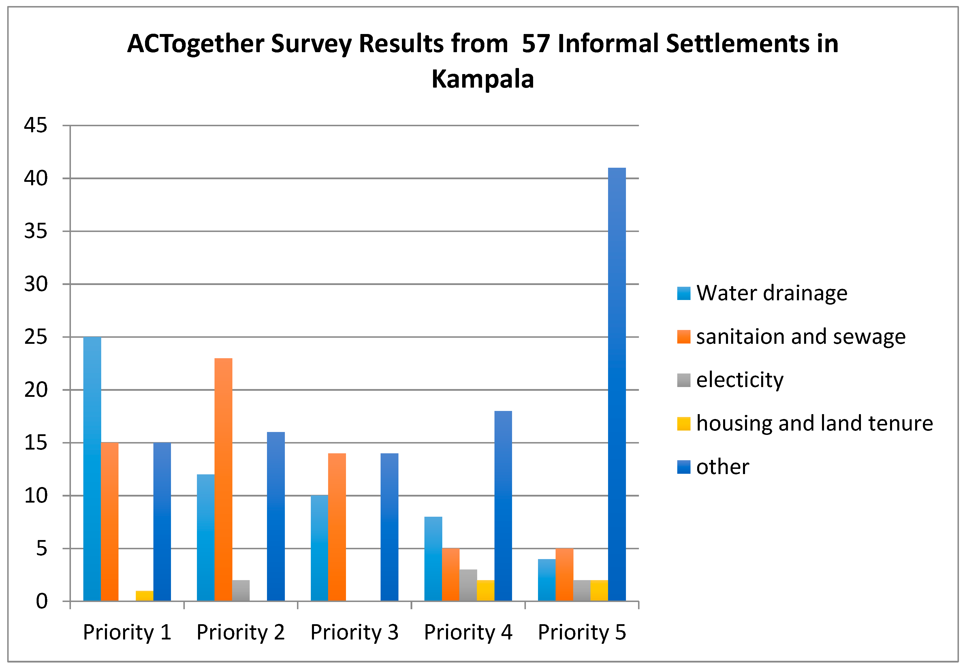
Using the ACTogether list of community priorities, which is developed by surveying community members and savings groups within the community, we determined that the most important drivers of vulnerability in Kampala’s slums are water and sanitation (see
Figure 1). These surveys are administered by the community members themselves and there is no clear record on how many respondents there were for each survey. However, generally all savings groups were polled within a community—in Kampala central, for example, there are 78 savings groups. These savings groups consist primarily of community leaders.
Figure 1 also highlights that survey respondents listed the category “other” as a priority. Other common concerns are health care, streetlights, garbage collection, mosquitos, and road networks. These concerns are everyday hazards and are the main cause of premature death and serious injury in these communities [
27].
5. Water: A Leading Source of Vulnerability in Kampala’s Slums
Water vulnerability is consistently highlighted as a major concern in Kampala (as seen in
Figure 1). Consequently, water will be analyzed more carefully. Water security indicators for urban areas do exist but tend to focus on the physical metrics of water scarcity and stress by estimating renewable freshwater resources and quantifying socio-economic conditions that would influence adaptive capacity [
32,
33]. In this study, vulnerability that stems from water is caused by lack of access to clean water, poor sanitation, and non-existent or limited waste management in the form of garbage collection. The water vulnerability score is calculated by normalizing and the data listed in
Table 1 on a scale from 0–1, where 1 is the least vulnerable. In this study, a score below 0.75 indicates enough risks are present that well-being is negatively affected, this threshold was determined by the authors and based on interviewing community leaders and experts in the field. Data for each slum are then aggregated and averaged (as discussed above) thus calculating a final score for each community (
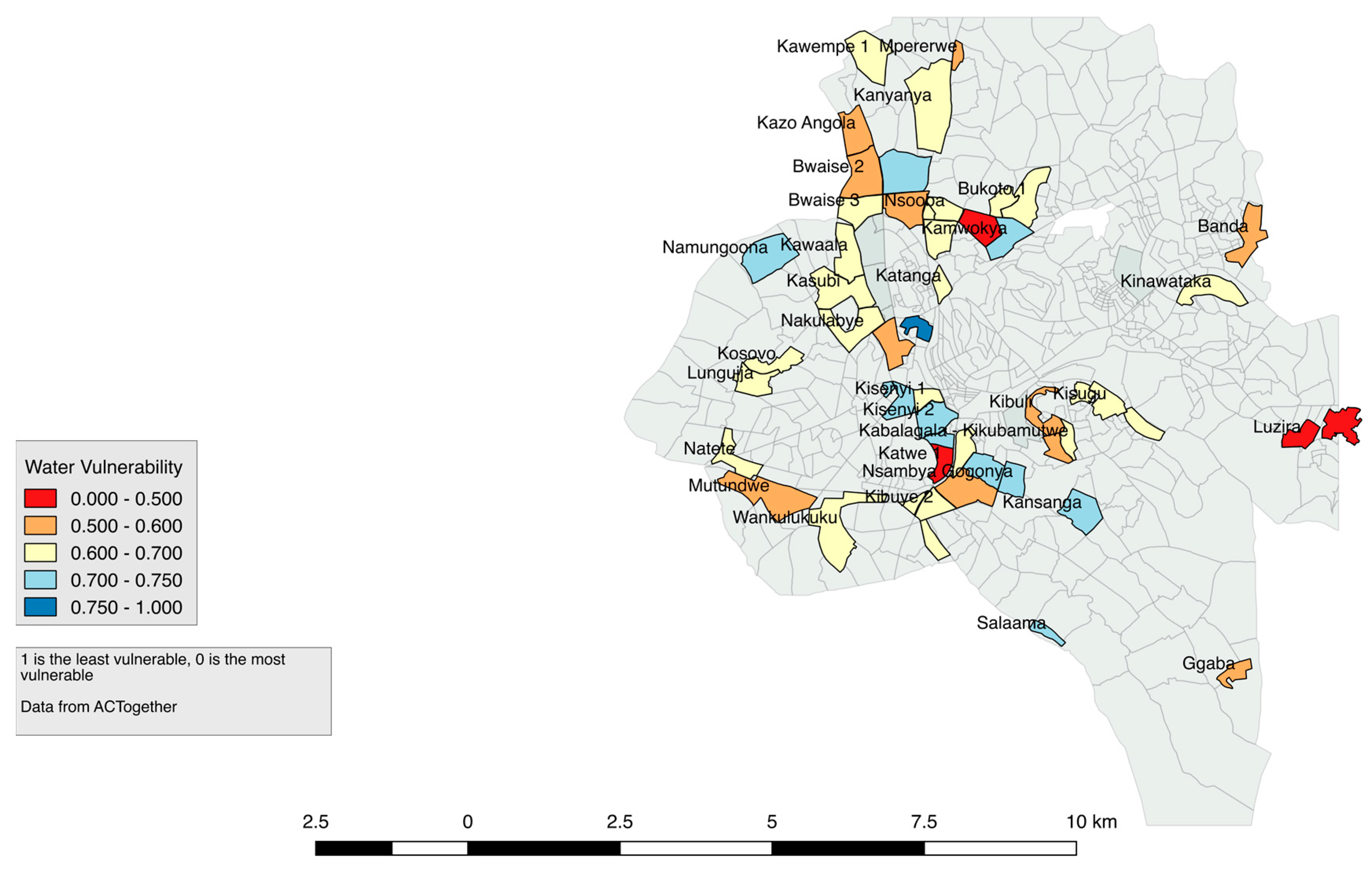
Figure 2). Only 1 of Kampala’s slum communities (Kagugube) have a water vulnerability score of above 0.75 suggesting that most of these slums are water vulnerable.
The fast growth of these areas coupled with the complete lack of infrastructure that might include sanitation facilities, roads, drainage systems and electricity, make supplying clean water an almost impossible task. Compounding this problem is the fact that many of these unplanned developments occur in low-lying areas that include wetlands. Development in wetlands significantly impedes the natural water filtration systems that the wetland normally would provide, thus degrading water sources. These areas are also prone to frequent and severe flooding. Informal settlements have polluted every wetland and fresh water spring surrounding Kampala. To further understand what is causing water vulnerability we disaggregated the driver into: water access vulnerability, sanitation vulnerability, and waste management vulnerability. This will give policy makers and urban planners the ability to understand the unique nature of water vulnerability in each community.
5.1. Clean Water Access
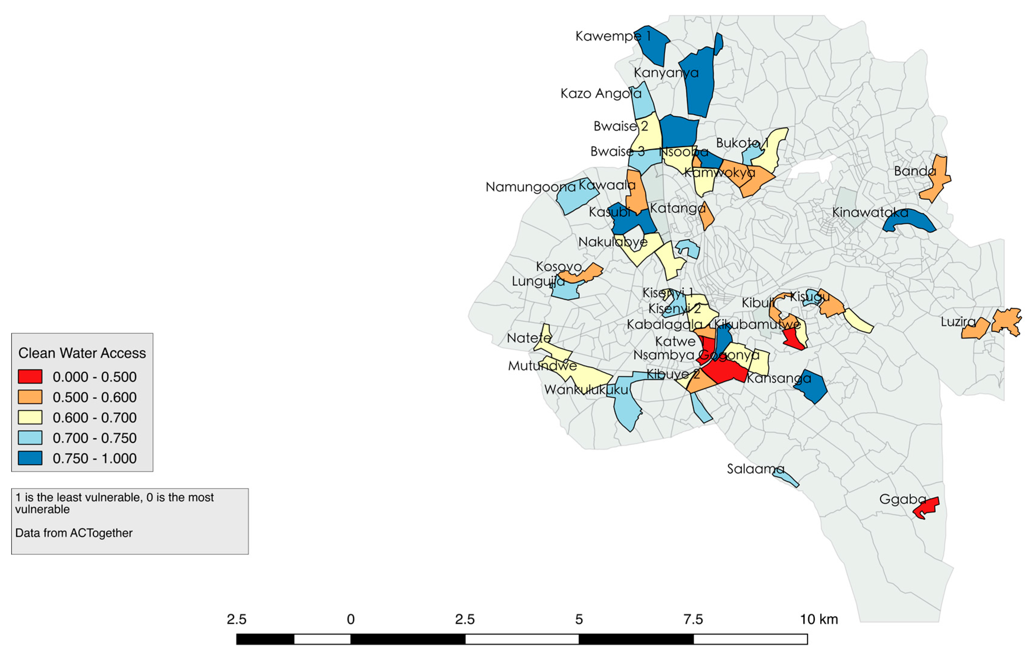
Forty-eight of Kampala’s 57 slums have a water access vulnerability score below 0.75, suggesting that the vast majority of slums are vulnerable because of water access (see
Figure 3). Based on our interviews water access is achieved predominately from piped water, ground water, and open springs. Piped water and ground water can be expensive, however it is cleaner, relatively speaking, than open springs, which are very contaminated. Access to piped water is dependent on land ownership and the ability to pay a connection fee. Considering the vast majority of people in the slum do not own land, piped water is untenable for most unless they pay a stand pipe manager for access to the pipe. Generally, water is expensive and makes up a considerable portion of the household budget. The national government charges about 20–40 shillings (USD 0.005–0.01) for a jerry can of water (about 20 L). In a slum, the same amount is usually 200–400 shillings (USD 0.06–0.11). Households that cannot afford to pay for water are forced to use open springs, which are highly contaminated from pit latrines located nearby. Taps are frequently turned off by the city water municipality for hours at a time with no notice. This could be to fix existing infrastructure or because of water shortages. When this happens, everybody in the community must use the contaminated spring water or walk long distances to a tap that has not been turned off and endure long wait times.
5.2. Sanitation
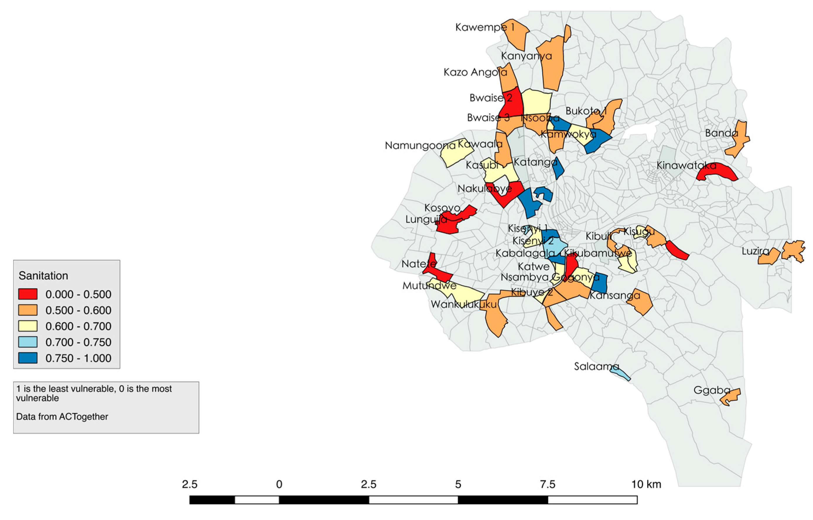
Forty-nine of Kampala’s 57 slums have a water sanitation vulnerability score of below 0.75 and 50 of these districts have a score of below 0.7, suggesting that sanitation is a key driver of overall water vulnerability (see
Figure 4). Pit latrines are the major source of water contamination and the major driver of poor sanitation. The government has outlawed pit latrines, however there is no alternative. During the rainy season, pit latrines are emptied into the drainage ditches, which then drains into wetlands and eventually into Lake Victoria further contaminating the Lake. Lack of adequate infrastructure exasperates and perpetuates this situation. Only 7% of the population in Kampala is served by a sewer system. Low sewer coverage is predicted to continue for decades as a citywide sewer system is neither affordable nor feasible. The majority of planned sanitation takes the form of poor quality septic tanks that frequently leak into groundwater. Many of the wetlands surrounding Kampala offer a filtration system for this effluent before it reaches the lake, however the efficiency of these wetlands has been drastically reduced because they have been drained for farmland and settlement [
34]. In Uganda, it is estimated that 72% of the pollution entering Lake Victoria enters from Kampala.
5.3. Waste Management
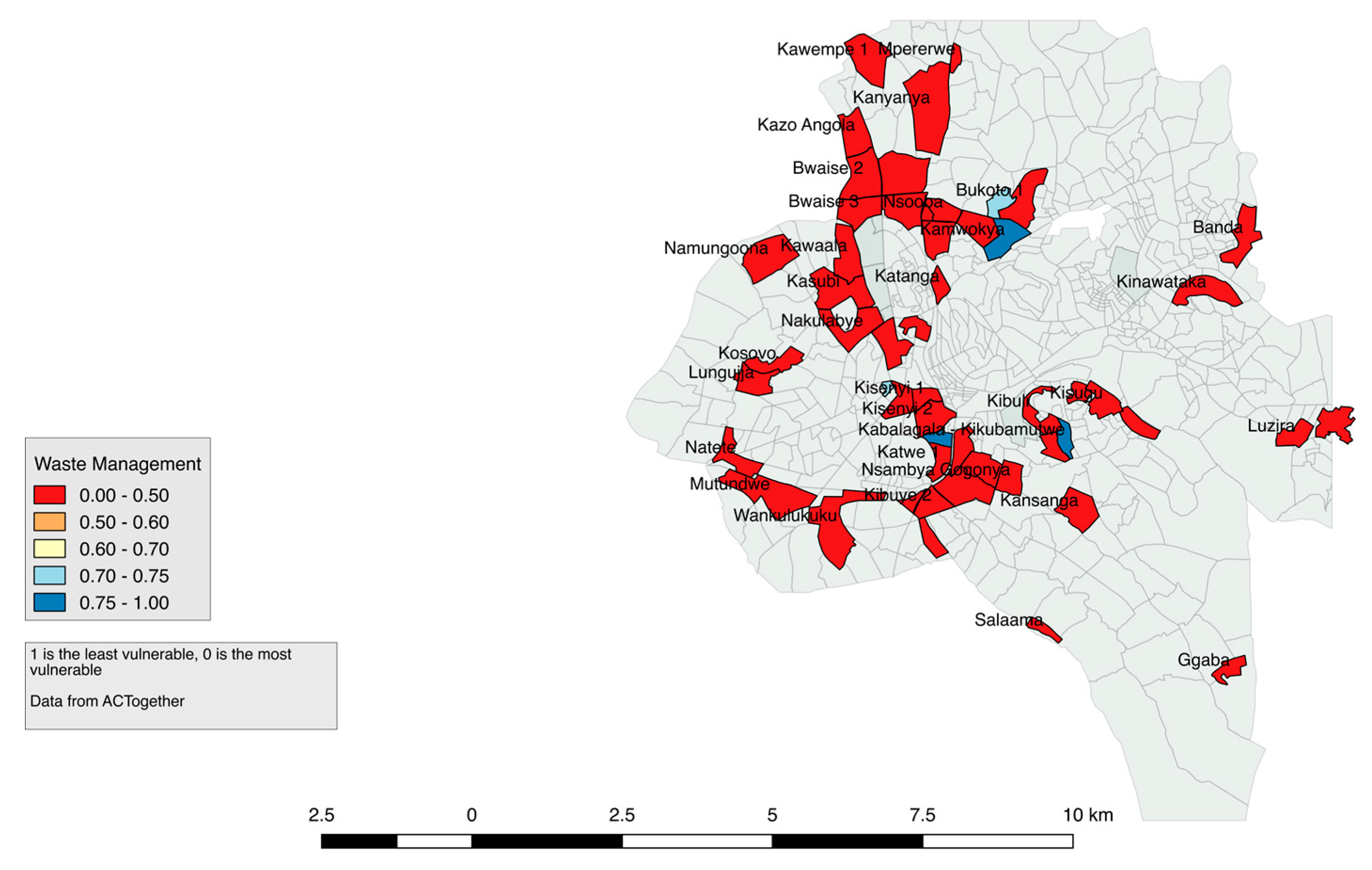
Fifty-four of the 57 slums have a waste management vulnerability score of below 0.75 and 53 of these communities have a score of below 0.5, suggesting that waste management is the largest driver of water vulnerability (see
Figure 5). Garbage collection is one of the most frequently mentioned concerns in the other category (
Figure 1). It is important to consider waste management as a driver of water vulnerability because uncollected solid waste clogs storm water drains (
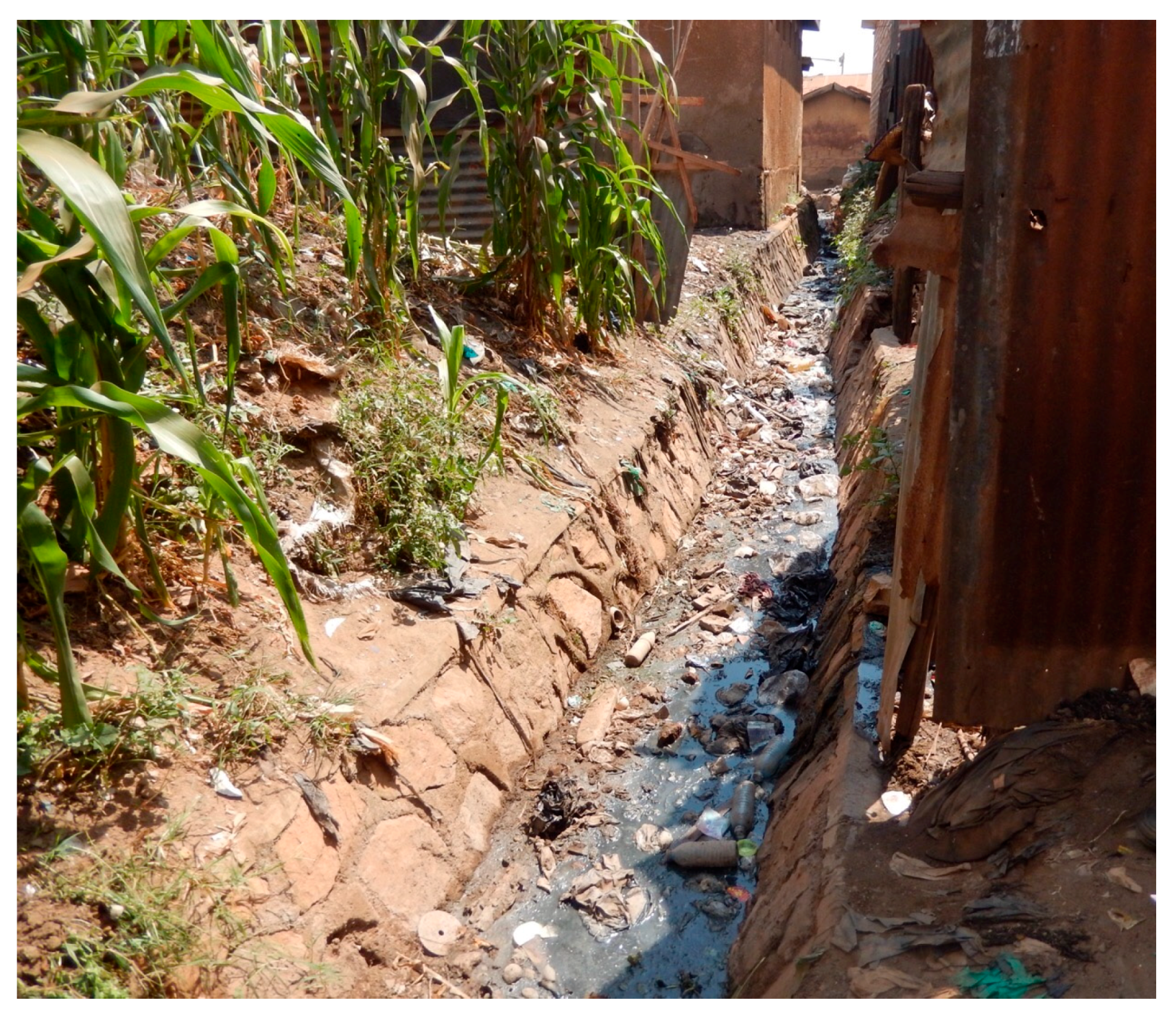
Figure 6). This exacerbates flooding and pollutes surface and ground water, which eventually enters Lake Victoria—the primary source of water for the Kampala. One of the main reasons why garbage is not collected is because of the lack of road networks that would allow garbage trucks access. Trucks that do make it into the community are often far from people’s houses and they do not come at reliable times. Rapid population growth also results in increased garbage generation, which the city lacks the capacity to deal with.
6. The Role of Urban Planning in Reducing Vulnerability
Adequate and effective urban planning can reduce the risks associated with the drivers of vulnerability. Effective urban planning involves identifying the unique drives of vulnerability in each community, allowing urban planners and policy makers to tailor their approach for each community. However, planning in Kampala is difficult and not well implemented, primarily because of Kampala’s complicated land tenure system. Most residents in slum communities do not own the land upon which they reside. In some cases, 75% of the slum is owned by just a handful of residents [
17]. Five different land tenure systems exist in Kampala, many of them overlapping. Different land types offer different levels of security. For example, the government can and has cleared public land to make way for a new project. In contrast, Mailo land is land that is rented from the Crown with 99-year leases [
35], which make them reasonably secure from evictions.
6.1. To Clear or to Upgrade
Anayana Roy [
7] accurately distills this choice as part of the broader trends of urbanization. She explores policy reactions to informality, explaining that there have been two primary paradigms: the more confrontational, traditional approach seeks to disrupt and clear the informal and the more recent approach, which has been to use participatory upgrading. This is often done, as we see in Kampala, by NGOs such as ACTogether and community leadership. Upgrading seeks to improve the lives and reduce the vulnerability of those already working in and inhabiting these spaces. Sanitation and infrastructure improvements along with formalizing land rights all fit under this category. Municipalities traditionally opted for the former approach, and that tendency persisted into the 1990s. More recently, however, governments have commonly espoused and pursued participatory upgrading [
7].
At face value, participatory upgrading appears the preferable option of the two. Clearing can lead to even more disenfranchisement and depravity and does little to address the existing drivers of vulnerability in the community and most often introduces new risks, hence compounding vulnerability. By forcing people off land, the Municipality has addressed no structural issues that compelled their activity in the first place [
26,
27,
28,
29,
30,
32,
33,
34,
36,
37]. Rather, spatial displacement ensues, frequently resulting in new sites being developed [
15]. Planning and design techniques that integrate existing local physical and social characteristics are more effective at maintaining the local identity of the community and improving welfare in the settlement [
11].
An example of clearing occurred in Bwaise, an informal settlement in Northern Kampala (see
Figure 2 for location), the national government launched a 2013 initiative to expand a major artery to Western Uganda from Kampala that borders the settlement, transforming the road into a four-lane freeway with overpasses [
38]. The settlement’s proximity to the project meant that displacement of at least part of the population was inevitable. As construction began, the authorities pushed a small portion off their land. Bwaise rests in a wetland, and rather than move further out from the already peripheral settlement, the populations clustered closer together and spread further into marshy land. Furthermore, it appears that the road’s construction amplified runoff issues and increased the likelihood of flooding. Clearing for a new infrastructure project did not improve the livelihoods of those in the settlement. Rather, it worsened already existing issues, including amplifying water vulnerability.
6.2. Kampala’s Written Strategy
The city’s written strategy appears very much in line with the upgrading philosophy. As detailed in the 2015–2016 Kampala Capital City Authority (KCCA) strategic vision, the Authority is forthright in admitting the problem, noting that 560,000 Kampalans who currently inhabit these 62 settlements often fail to comply with minimum humanitarian standards [
39]. The KCCA strategy lays out a full array of participatory measures to deal with informality. Without providing any detail on funding mechanisms, implementation authority, or any detail on a timeline beyond over the next five years.
KCCA’s 2015–2016 strategic plan intentionally lacks depth, as a more detailed plan is found in the Kampala Physical Development Plan (KPDP), published in 2012. In this document, KCCA lays out a more detailed assessment of Kampala and the steps it plans to address remaining issues. The plan makes a massive financial demand, estimating
$6 billion for infrastructure and
$33 billion in maintenance over the life of the plan [
39]. The current budget allocations come nowhere near to providing that amount [
40]. The National Urban Situation Analysis Report [
17] suggests that there is inadequate capacity, including a staff shortfall of over 30%, for the local government to achieve their planning goals.
The mechanism they propose to address the settlement question is densification, or encouraging taller and larger buildings on standard, deeded plots of land. The participatory intent is clear in the calls for upgrading. They mandate providing and/or upgrading infrastructure and proactive ‘out-reach,’ guidance and support for implementation [
39]. A recent report written after a three-year study by the European Union, suggests that inter-communal conflict in Kampala’s slums are caused primarily by poverty and unemployment [
40]. The report suggests that poor conditions in the slums need to improve to reduce poverty and violence. In response a KCCA spokesman said they are introducing a new plan that will redevelop the slums so that people living there have better housing services [
41]. Identifying the key drivers of vulnerability through interviews and surveys such as ACTogether has done, will help focus slum upgrading more effectively and root planning and management in a local context.
6.3. Participatory Planning
In general, KCCA upgrading attempts focus on top-down approaches, making rules and enforcing them. That is far easier and less resource intensive than the bottom-up approach of ACTogether. However, this has resulted in mistrust between the community and the city government. Staff at ACTogether put it plainly: on a given day, KCCA will decide to undertake a project such as the Northern Bypass and evict residents. They may compensate them for the property or promise they will be able to move back once the project is complete. Rarely does a plan exist for these people, and their experience shows that the result is more often spatial and social displacement. When they do construct “low-cost housing” where the settlements once existed, it is generally too expensive for the previous residents to return. In addition, these “low-cost housing” communities do little to remedy the initial drivers of vulnerability, such as adequate access to clean, affordable water and sanitation.
ACTogether’s bottom-up approach, on the other hand, relies upon working closely with those people to improve their situations where they currently live. Bwaise is home to numerous sanitation projects spearheaded by the organization. Despite the wetland environment making sanitation projects difficult, ACTogether built functioning latrines next to decrepit, already broken, one-year old KCCA pit latrines. Part of the reason the KCCA latrines were not working is because they were planned without adequate community involvement and were not maintained. As explained to us in interviews, the placement of the latrines was not discussed with the community and the community was not involved with maintenance or managing the latrines. KCCA was not able to provide adequate maintenance and hence the latrines became unusable. One community leader explained that in one case people were vacated from their land to make way for a latrine. This resulted in community protests and conflict.
The contrast between the two organizations and their successes and failures illustrates the challenges of reducing risk in informal settlement. Kassahun [
42] argues that social trust and confidence in institutions results in increased participation in local associations. To implement change in communities, it is important to engage the local associations because as Kassahun explains, the “connectedness through membership in the local association has created a bonding and bridging type of social capital…” (p. 15). In other words, slum dwellers trust their local associations and therefore upgrading and planning initiatives that involve these organizations will not only take the community needs into consideration but tailor actions to community specific risks. Consequently, they will be better received by the community and the overall vulnerability of the community will be decreased. The example mentioned above highlights this: latrines that were built by ACTogether were used by the community, but KCCA latrines were not. Because of these functioning and maintained latrines, the risk associated with poor sanitation was reduced.
7. Conclusions
Kampala’s growth is expected to continue, so planning is necessary to accommodate this growth, however planning must address the drivers of vulnerability and reduce risk. The informal settlement is a critical part of the fabric of the city. As these cities grow, the burden on environmental resources, such as water, will continue to increase. Adequate municipal services and infrastructure are necessary to improve livelihoods and decrease vulnerability in these settlements. Urban planning, using bottom-up approaches, can influence where infrastructure, such as sanitation facilities and water pipes, should be located. Consequently, the risks associated with not having adequate facilities or facilities that are not used because of improper location, is eliminated. Effective urban planning and adequate funding into basic infrastructure, directly improves the health and the sustainability of the city. The results from this study highlight how important it is to consider the specific needs of a community when conducting urban planning. Most of the communities in this study are vulnerable because of water, however the specific drivers of water vulnerability vary based on the community. Providing urban planners with community specific concerns will contribute to identifying risks, implementing policy, and designing effective urban plans that best reduce vulnerability. Community involvement is paramount to this type of urban development. For example, community involvement can help planners decide where garbage pickups should be located, or the best location for latrines.
African cities can be major assets for development but only when planning considers the drivers of vulnerability and how they affect human livelihoods. Planning must also involve community members in decision making. Cities that are well managed can provide enormous potential and opportunities. As Uganda’s lead newspaper states in an April 2017 op-ed “Happiness in cities is determined by the organizational set-up. Congested and poorly planned cities like Kampala are not only stressful to live in, they are dream killers because of the effort it takes for people afford basic necessities.” [
43].


