Next Issue
Volume 3, September
Previous Issue
Volume 3, March


Urban Sci., Volume 3, Issue 2 (June 2019) – 27 articles

Cover Story (view full-size image): 
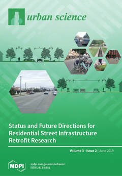
The cover image visualizes two residential street scenarios. The bottom one depicts a typical conventional residential street in an automobile-dependent suburban location in New Zealand. Such streets have been perceived as ecologically unsustainable, antisocial, unhealthy, and aesthetically unpleasant. The top scenario shows examples of how residential streets can be improved through infrastructure retrofits, particularly by combining green and grey infrastructures and integrating various functions and services. Our analysis of the status of retrofit research suggests changing infrastructure compositions and a trend toward increased grey and green–grey infrastructure integration. However, while such retrofits are potentially able to increase the number and quality of landscape services that support human well-being, more substantial research is required to analyze their implementation and provide [...] Read more.
Order results
Result details
Select all
Export citation of selected articles as:
15 pages, 3217 KiB  
Article
Homeless Interactions with the Built Environment: A Spatial Pattern Language of Abandoned Housing
by Abram Kaplan, Kim Diver, Karl Sandin and Sarah Kafer Mill
Urban Sci. 2019, 3(2), 65; https://doi.org/10.3390/urbansci3020065 - 25 Jun 2019
Cited by 2 | Viewed by 6488
Abstract
Research demonstrates that homeless individuals use urban space in adaptive and endemic ways. Investigations at city and neighborhood scales would benefit from attention to homeless use of abandoned housing. We employ the pattern language approach developed by Christopher Alexander for twenty-two abandoned houses [...] Read more.
Research demonstrates that homeless individuals use urban space in adaptive and endemic ways. Investigations at city and neighborhood scales would benefit from attention to homeless use of abandoned housing. We employ the pattern language approach developed by Christopher Alexander for twenty-two abandoned houses in Newark, Ohio. We use statistical and geospatial data analyses to evaluate hypotheses related to prospect and refuge site qualities, accessibility, and attractiveness to homeless persons, and the proximity of sites to resources. Factors related to prospect/refuge, accessibility, and resource proximity were consistent with the hypotheses. Results can be grouped into four distinct patterns: ‘Hiding Places,’ ‘Welcome Mat,’ ‘Shelter (Un)becoming,’ and ‘Proximity to Resources.’ Based on these patterns, we conclude with recommendations for officials and organizations addressing homelessness. Full article
Show Figures

Figure 1

32 pages, 8228 KiB  
Essay
A Search for Beauty/A Struggle with Complexity: Christopher Alexander
by Richard P. Gabriel and Jenny Quillien
Urban Sci. 2019, 3(2), 64; https://doi.org/10.3390/urbansci3020064 - 16 Jun 2019
Cited by 14 | Viewed by 9179
Abstract
Beauty. Christopher Alexander’s prolific journey in building, writing, and teaching was fueled by a relentless search for Beauty and its meaning. While all around him the world was intent on figuring out how to simplify, Alexander came to embrace complexity as the only [...] Read more.
Beauty. Christopher Alexander’s prolific journey in building, writing, and teaching was fueled by a relentless search for Beauty and its meaning. While all around him the world was intent on figuring out how to simplify, Alexander came to embrace complexity as the only path to his goal. The Beauty and life of that which he encountered and appreciated—an Indian village, a city, a subway network, an old Turkish carpet, or a campus—lay in its well-ordered complexity. As a designer and maker he found that simplicity came from choosing—at every step—the simplest way to add the necessary complexity. The failure of so much of our modern world, in Alexander’s eyes, was oversimplification, wantonly bulldozing context, misunderstanding the relationships of part and whole, ignoring the required role of time in the shaping of shapes, and ultimately dismissing, like Esau, our birthright of Value in favor of a lentil pottage of mere Fact. Ever elusive, Beauty demands of her suitors a constant return of attention to see what might be newly revealed, and Alexander duly returned again and again in pursuit of the mystery. In this essay—essentially biographical and descriptive of one man’s endeavors—we examine the full arc of his work from dissertation to most recent memoir. We don’t shy away from his failures, and we don’t simplify his journey. We leave work done by other scholars for another day. We reach no conclusion, rather, we invite readers to reflect on what Alexander’s lifelong effort suggests to them about their own path, their own sense of aesthetics and order, innate cognitive shortfalls, and professional blind alleys. Full article
Show Figures

Figure 1

15 pages, 3806 KiB  
Article
Urban Landscape Structure of a Fast-Growing African City: The Case of Niamey (Niger)
by Jean-Pierre Rossi and Gauthier Dobigny
Urban Sci. 2019, 3(2), 63; https://doi.org/10.3390/urbansci3020063 - 14 Jun 2019
Cited by 6 | Viewed by 4187
Abstract
Combining multivariable statistics and geostatistics with landscape metrics, we attempted to quantify the spatial pattern of urbanization in the city of Niamey, Niger. Landscape metrics provided local quantification of both landscape composition and physiognomy while the Principal Component Analysis (PCA) yielded a multivariable [...] Read more.
Combining multivariable statistics and geostatistics with landscape metrics, we attempted to quantify the spatial pattern of urbanization in the city of Niamey, Niger. Landscape metrics provided local quantification of both landscape composition and physiognomy while the Principal Component Analysis (PCA) yielded a multivariable summary of the main source of landscape metrics variation across the city. We used the variogram (geostatistics) to analyze the spatial pattern of the PCA outcomes and to characterize the associated spatial scales of variation. In Niamey, the main urban structure corresponded to a gradient ranging from highly diversified, fragmented, and both wooded and built-up areas in the city center and along the Niger River, to less green zones gathering steel-roofed houses whose density diminished towards the periphery. This concentric structure centered on the Niger River clearly reflected the history of Niamey. PCA and geostatistics provided appealing quantitative estimates of spatial patterns, scales, anisotropy and intensity of urban structures. Although these different tools are known in landscape ecology, they are rarely used together. The present paper illustrates how they allow characterizing the marked spatial variation of the urban landscape of the fast-growing African city of Niamey (Niger). Such a quantification of the urban landscapes may be extremely useful for future correlative investigations in various fields of research and planning. Full article
Show Figures

Figure 1

20 pages, 4631 KiB  
Article
Correcting Bias in Crowdsourced Data to Map Bicycle Ridership of All Bicyclists
by Avipsa Roy, Trisalyn A. Nelson, A. Stewart Fotheringham and Meghan Winters
Urban Sci. 2019, 3(2), 62; https://doi.org/10.3390/urbansci3020062 - 4 Jun 2019
Cited by 45 | Viewed by 7859
Abstract
Traditional methods of counting bicyclists are resource-intensive and generate data with sparse spatial and temporal detail. Previous research suggests big data from crowdsourced fitness apps offer a new source of bicycling data with high spatial and temporal resolution. However, crowdsourced bicycling data are [...] Read more.
Traditional methods of counting bicyclists are resource-intensive and generate data with sparse spatial and temporal detail. Previous research suggests big data from crowdsourced fitness apps offer a new source of bicycling data with high spatial and temporal resolution. However, crowdsourced bicycling data are biased as they oversample recreational riders. Our goals are to quantify geographical variables, which can help in correcting bias in crowdsourced, data and to develop a generalized method to correct bias in big crowdsourced data on bicycle ridership in different settings in order to generate maps for cities representative of all bicyclists at a street-level spatial resolution. We used street-level ridership data for 2016 from a crowdsourced fitness app (Strava), geographical covariate data, and official counts from 44 locations across Maricopa County, Arizona, USA (training data); and 60 locations from the city of Tempe, within Maricopa (test data). First, we quantified the relationship between Strava and official ridership data volumes. Second, we used a multi-step approach with variable selection using LASSO followed by Poisson regression to integrate geographical covariates, Strava, and training data to correct bias. Finally, we predicted bias-corrected average annual daily bicyclist counts for Tempe and evaluated the model’s accuracy using the test data. We found a correlation between the annual ridership data from Strava and official counts (R2 = 0.76) in Maricopa County for 2016. The significant variables for correcting bias were: The proportion of white population, median household income, traffic speed, distance to residential areas, and distance to green spaces. The model could correct bias in crowdsourced data from Strava in Tempe with 86% of road segments being predicted within a margin of ±100 average annual bicyclists. Our results indicate that it is possible to map ridership for cities at the street-level by correcting bias in crowdsourced bicycle ridership data, with access to adequate data from official count programs and geographical covariates at a comparable spatial and temporal resolution. Full article
Show Figures

Figure 1

13 pages, 248 KiB  
Article
Autonomous Road Vehicles: Challenges for Urban Planning in European Cities
by Nikolaos Gavanas
Urban Sci. 2019, 3(2), 61; https://doi.org/10.3390/urbansci3020061 - 3 Jun 2019
Cited by 49 | Viewed by 7618
Abstract
Autonomous vehicles will significantly affect mobility conditions in the future. The changes in mobility conditions are expected to have an impact on urban development and, more specifically, on location choices, land use organisation and infrastructure design. Nowadays, there is not enough data for [...] Read more.
Autonomous vehicles will significantly affect mobility conditions in the future. The changes in mobility conditions are expected to have an impact on urban development and, more specifically, on location choices, land use organisation and infrastructure design. Nowadays, there is not enough data for a real-life assessment of this impact. Experts estimate that autonomous vehicles will be available for uptake in the next decade. Therefore, urban planners should consider the possible impacts from autonomous vehicles on cities and the future challenges for urban planning. In this context, the present paper focuses on the challenges from the implementation of autonomous road vehicles for passenger transport in European cities. The analysis is based on a systematic review of research and policy. The main outcome of the analysis is a set of challenges for urban planning regarding the features of urban development, the local and European policy priorities, the current lack of data for planning and the potential for autonomous vehicles to be used by planners as data sources. The paper concludes that tackling these challenges is essential for the full exploitation of the autonomous vehicles’ potential to promote sustainable urban development. Full article
(This article belongs to the Special Issue The Future of Urban Transportation and Mobility Systems)
14 pages, 245 KiB  
Article
Addressing Urban Sprawl from the Complexity Sciences
by Martí Bosch, Jérôme Chenal and Stéphane Joost
Urban Sci. 2019, 3(2), 60; https://doi.org/10.3390/urbansci3020060 - 1 Jun 2019
Cited by 14 | Viewed by 4807
Abstract
Urban sprawl is nowadays a pervasive topic that is subject of a contentious debate among planners and researchers, who still fail to reach consensual solutions. This paper reviews controversies of the sprawl debate and argues that they owe to a failure of the [...] Read more.
Urban sprawl is nowadays a pervasive topic that is subject of a contentious debate among planners and researchers, who still fail to reach consensual solutions. This paper reviews controversies of the sprawl debate and argues that they owe to a failure of the employed methods to appraise its complexity, especially the notion that urban form emerges from multiple overlapping interactions between households, firms and governmental bodies. To address such issues, this review focuses on recent approaches to study urban spatial dynamics from the perspective of the complexity sciences. Firstly, spatial metrics from landscape ecology provide means of quantifying urban sprawl in terms of increasing fragmentation and diversity of land use patches. Secondly, cellular automata and agent-based models suggest that the prevalence of urban sprawl and fragmentation at the urban fringe emerge from negative spatial interaction between residential agents, which seem accentuated as the agent’s preferences become more heterogeneous. Then, the review turns to practical applications that employ such models to spatially inform urban planning and assess future scenarios. A concluding discussion summarizes potential contributions to the debate on urban sprawl as well as some epistemological implications. Full article
18 pages, 1587 KiB  
Review
Assessing Alexander’s Later Contributions to a Science of Cities
by Michael W. Mehaffy
Urban Sci. 2019, 3(2), 59; https://doi.org/10.3390/urbansci3020059 - 30 May 2019
Cited by 7 | Viewed by 5186
Abstract
Christopher Alexander published his longest and arguably most philosophical work, The Nature of Order, beginning in 2003. Early criticism assessed that text to be a speculative failure; at best, unrelated to Alexander’s earlier, mathematically grounded work. On the contrary, this review presents [...] Read more.
Christopher Alexander published his longest and arguably most philosophical work, The Nature of Order, beginning in 2003. Early criticism assessed that text to be a speculative failure; at best, unrelated to Alexander’s earlier, mathematically grounded work. On the contrary, this review presents evidence that the newer work was a logically consistent culmination of a lifelong and remarkably useful inquiry into part-whole relations—an ancient but still-relevant and even urgent topic of design, architecture, urbanism, and science. Further evidence demonstrates that Alexander’s practical contributions are remarkably prodigious beyond architecture, in fields as diverse as computer science, biology and organization theory, and that these contributions continue today. This review assesses the potential for more particular contributions to the urban professions from the later work, and specifically, to an emerging “science of cities.” It examines the practical, as well as philosophical contributions of Alexander’s proposed tools and methodologies for the design process, considering both their quantitative and qualitative aspects, and their potential compatibility with other tools and strategies now emerging from the science of cities. Finally, it highlights Alexander’s challenge to an architecture profession that seems increasingly isolated, mired in abstraction, and incapable of effectively responding to larger technological and philosophical challenges. Full article
Show Figures

Figure 1

18 pages, 4400 KiB  
Article
Charting Participatory Action and Interventionist Research Processes for Community-Based Stakeholders in Peri-Urban Contexts: The Proposed St. Cuthbert’s Community Centre, Lorne, Australia
by Igor Martek, Mark B. Luther, Stewart Seaton, Glenn Costin, Hong Xian Li, Olubukola Tokede and David Sydney Jones
Urban Sci. 2019, 3(2), 58; https://doi.org/10.3390/urbansci3020058 - 28 May 2019
Viewed by 3371
Abstract
Participatory action combined interventionist research approaches can offer possibilities for community-based facilities and institutions attempting to re-engage with their communities and assert their presence. St. Cuthbert’s Church is a heritage-listed property, located on a major landholding, right in the heart of the summer [...] Read more.
Participatory action combined interventionist research approaches can offer possibilities for community-based facilities and institutions attempting to re-engage with their communities and assert their presence. St. Cuthbert’s Church is a heritage-listed property, located on a major landholding, right in the heart of the summer tourist town of Lorne, on Melbourne’s peri-urban ‘sea change’ fringe. Its sloping hillside vantage offers spectacular views to the beach and Bass Strait, beyond. The congregation, however, is aging, while the broader community is increasingly secular. In response to these circumstances, the Church is looking to assert its relevance with the procurement of a community centre to be erected on the property. Using an interventionist research approach, with a professional facilitator in ‘participatory action design’, it was found that while both residents and visitors to Lorne were favourably disposed to the idea of a community centre, it was also clear that the locus of power that needed to realise this objective lay outside the congregation’s control. A conclusion of this research is that community-based organisations may have to pro-actively engage in professional marketing and prepare business plans, as well as engage in substantial political lobbying both within and external to the Church, if the project is to progress and succeed. Full article
Show Figures

Figure 1

10 pages, 233 KiB  
Article
Selecting Potential Moss Species for Green Roofs in the Mediterranean Basin
by Ricardo Cruz de Carvalho, Zulema Varela, Teresa Afonso do Paço and Cristina Branquinho
Urban Sci. 2019, 3(2), 57; https://doi.org/10.3390/urbansci3020057 - 26 May 2019
Cited by 13 | Viewed by 5057
Abstract
Green roofs are important infrastructures to address the effects of climate change in urban areas. However, most studies and applications have been done in cooler and wetter regions of the northern hemisphere. Climate change will lead to more extreme weather events, such as [...] Read more.
Green roofs are important infrastructures to address the effects of climate change in urban areas. However, most studies and applications have been done in cooler and wetter regions of the northern hemisphere. Climate change will lead to more extreme weather events, such as increased drought and decreased precipitation with intense flash rain events. Increase desertification is expected especially in the Mediterranean Basin, where in summer, radiation and temperature are high and water is scarce. Therefore, while vascular plants increase water consumption in green roofs during warmer periods, mosses present themselves as potential candidates due to their poikilohydric nature, responding to the environmental availability of water, completely drying out and recovering upon rehydration. Although criteria for the selection of vascular plants adapted to the Mediterranean and suitable for green roofs have been developed, no information is available regarding the selection of mosses based on scientific criteria. Here we propose selection criteria for moss species based on ecological preferences according to Ellenberg’s values and help to define moss traits suitable for a nonirrigated, nature-based green roof that tolerates the Mediterranean climate. The main result is a table of potential candidate mosses that can be either used as standalone or in conjunction with vascular plants to decrease water usage and/or manage stormwater through an easily applicable selection methodology. For green roof practitioners, we proposed that acrocarpous mosses exhibiting turf/cushion life forms and colonist or perennial life strategies best fit the requirements for such a green infrastructure in extreme climate regions with scarce water resources. Full article
11 pages, 414 KiB  
Essay
Human Ecology and Its Influence in Urban Theory and Housing Policy in the United States
by Ivis García
Urban Sci. 2019, 3(2), 56; https://doi.org/10.3390/urbansci3020056 - 22 May 2019
Cited by 10 | Viewed by 13406
Abstract
Human ecology, a stream of planning, was developed by Park, Burgess, and Hoyt. This theoretical model emphasized mobility and assimilation as natural paths to housing. This essay offers an analysis of its influence on urban theory and policymaking in the United States. Using [...] Read more.
Human ecology, a stream of planning, was developed by Park, Burgess, and Hoyt. This theoretical model emphasized mobility and assimilation as natural paths to housing. This essay offers an analysis of its influence on urban theory and policymaking in the United States. Using planning-specific analyses, the author interrogates the relationships between structural and ecological interpretations of urban change within early planning theory. A particular focus is given to housing policies and models such as tipping point, segregation, and gentrification. These human ecological interpretations inspired and shaped urban renewal and redlining practices, along with public and affordable housing in the United States. The essay concludes with a criticism of the ecological ideas of spontaneous order and the claims of naturally balancing economic systems and conceptions of personal responsibility and choice. Full article
Show Figures

Figure 1

10 pages, 1310 KiB  
Article
Sustainable Urban Transport Development by Applying a Fuzzy-AHP Model: A Case Study from Mersin, Turkey
by Sarbast Moslem and Szabolcs Duleba
Urban Sci. 2019, 3(2), 55; https://doi.org/10.3390/urbansci3020055 - 20 May 2019
Cited by 30 | Viewed by 4130
Abstract
Sustainable development decisions generally require citizen participation in the decision process to avoid public resistance and objections in the long term. Because of the involvement of non-experts, the uncertainty of the decision is increased, and this must be considered in the decision-making process. [...] Read more.
Sustainable development decisions generally require citizen participation in the decision process to avoid public resistance and objections in the long term. Because of the involvement of non-experts, the uncertainty of the decision is increased, and this must be considered in the decision-making process. This paper aims to introduce a sustainable urban transport development problem in which citizens are involved to allow them to express their preferences for improving certain elements of the public bus system. To mitigate the uncertainty of the non-expert evaluations, a fuzzy-analytic hierarchy process (AHP) model has been created and applied. Since the objective of the research is to provide a suitable framework for transport development tenders, only the criteria weights have to be determined; thus, an alternative level has not been applied. The model has been tested on the urban bus transport system of a large Turkish city: Mersin. Based on the application, citizen preference weights could be associated with certain elements of the supply quality; thus, government development source allocation decisions could be supported. The fuzzy-AHP model ensures that the final development implications will meet public demand for bus system improvement in the city. Full article
Show Figures

Figure 1

13 pages, 573 KiB  
Article
Coping with Floods in Pikine, Senegal: An Exploration of Household Impacts and Prevention Efforts
by Hilary Hungerford, Sarah L. Smiley, Taylor Blair, Samantha Beutler, Noel Bowers and Eddy Cadet
Urban Sci. 2019, 3(2), 54; https://doi.org/10.3390/urbansci3020054 - 18 May 2019
Cited by 7 | Viewed by 4049
Abstract
African cities are at increasing risk for disasters, including floods. Pikine, Senegal—located on the outskirts of the Dakar metropolitan region—has experienced regular floods since 2005 due to a rising water table, dense settlement, and inadequate drainage. The goal of this research was to [...] Read more.
African cities are at increasing risk for disasters, including floods. Pikine, Senegal—located on the outskirts of the Dakar metropolitan region—has experienced regular floods since 2005 due to a rising water table, dense settlement, and inadequate drainage. The goal of this research was to assess household experiences of floods through in-depth qualitative interviews in one area of Pikine. A total of 44 households were interviewed on the economic and health impacts of flooding and their perceptions of flood mitigation strategies. Our research confirmed that floods create substantial economic and health burdens for families and that infrastructure projects have helped, but not solved, the flooding issues. Our research also had some unexpected findings, particularly relating to concerns over drinking water, land tenure and housing prices, and perception of government intervention. Full article
(This article belongs to the Special Issue Urban Disaster and Recovery)
Show Figures

Figure 1

15 pages, 265 KiB  
Article
Exploring Differences in the Rate of Type 2 Diabetes Among American Cities: How Urbanization Continues to Challenge the Traditional Epidemiological View
by Barry P. Young
Urban Sci. 2019, 3(2), 53; https://doi.org/10.3390/urbansci3020053 - 16 May 2019
Cited by 1 | Viewed by 3382
Abstract
As the world’s largest urban regions continue to expand, a concomitant rise in non-communicable diseases, particularly type 2 diabetes, poses an increasingly ominous challenge to experts in the field of public health. Given that the majority of the world’s population (54%) resides in [...] Read more.
As the world’s largest urban regions continue to expand, a concomitant rise in non-communicable diseases, particularly type 2 diabetes, poses an increasingly ominous challenge to experts in the field of public health. Given that the majority of the world’s population (54%) resides in urban areas, a figure likely to reach two-thirds by 2050, this issue presents serious implications for medical practitioners as well as policymakers seeking to manage long-term healthcare costs while sustaining historic increases in life expectancy. To explore how these trends are continuing to affect the United States, a multiple regression analysis was conducted using data provided by the Centers for Disease Control and Prevention (CDC) through their initiative, 500 Cities: Local Data for Better Health. The regression models revealed that larger cities reported significantly higher rates of type 2 diabetes even after controlling for variables that have been perennially linked to disease onset (e.g., levels of obesity, sedentary behavior). Implications are discussed, most notably the argument for moving beyond the ‘food desert’ paradigm when identifying and explaining which characteristics of larger cities place their residents at increased risk. This approach could help reveal opportunities for intervention that may not have garnered sufficient attention in the extant literature. Full article
14 pages, 560 KiB  
Article
Innovative Arrangements between Public and Private Actors in Affordable Housing Provision: Examples from Austria, England and Italy
by Gerard van Bortel and Vincent Gruis
Urban Sci. 2019, 3(2), 52; https://doi.org/10.3390/urbansci3020052 - 8 May 2019
Cited by 12 | Viewed by 6021
Abstract
Affordable housing is increasingly developed, financed and managed by a mix of state, third-sector, market and community actors. This has led to the emergence of various hybrid governance and finance arrangements. This development can be seen as part of a general long-term neoliberal [...] Read more.
Affordable housing is increasingly developed, financed and managed by a mix of state, third-sector, market and community actors. This has led to the emergence of various hybrid governance and finance arrangements. This development can be seen as part of a general long-term neoliberal trend in government policies, and social, cultural and economic developments. It is therefore likely that the hybridity and variety of governance and finance of affordable housing will continue to grow. This article discusses innovative hybrid arrangements from Austria, England and Italy, in which governments, private and non-profit actors collaborate to increase the supply of affordable housing. These cases illustrate how the provision of affordable housing in a neoliberal context can benefit from the involvement of market actors and communities. Nevertheless, they also show that governments continue to play a crucial role in initiating and facilitating these arrangements. Full article
Show Figures

Figure 1

24 pages, 10518 KiB  
Article
How Do Cities Flow in an Emergency? Tracing Human Mobility Patterns during a Natural Disaster with Big Data and Geospatial Data Science
by Su Yeon Han, Ming-Hsiang Tsou, Elijah Knaap, Sergio Rey and Guofeng Cao
Urban Sci. 2019, 3(2), 51; https://doi.org/10.3390/urbansci3020051 - 6 May 2019
Cited by 37 | Viewed by 7122
Abstract
Understanding human movements in the face of natural disasters is critical for disaster evacuation planning, management, and relief. Despite the clear need for such work, these studies are rare in the literature due to the lack of available data measuring spatiotemporal mobility patterns [...] Read more.
Understanding human movements in the face of natural disasters is critical for disaster evacuation planning, management, and relief. Despite the clear need for such work, these studies are rare in the literature due to the lack of available data measuring spatiotemporal mobility patterns during actual disasters. This study explores the spatiotemporal patterns of evacuation travels by leveraging users’ location information from millions of tweets posted in the hours prior and concurrent to Hurricane Matthew. Our analysis yields several practical insights, including the following: (1) We identified trajectories of Twitter users moving out of evacuation zones once the evacuation was ordered and then returning home after the hurricane passed. (2) Evacuation zone residents produced an unusually large number of tweets outside evacuation zones during the evacuation order period. (3) It took several days for the evacuees in both South Carolina and Georgia to leave their residential areas after the mandatory evacuation was ordered, but Georgia residents typically took more time to return home. (4) Evacuees are more likely to choose larger cities farther away as their destinations for safety instead of nearby small cities. (5) Human movements during the evacuation follow a log-normal distribution. Full article
(This article belongs to the Special Issue Urban Disaster and Recovery)
Show Figures

Figure 1

15 pages, 1453 KiB  
Review
A Framework for Integrating Agriculture in Urban Sustainability in Australia
by Arif H. Sarker, Janet F. Bornman and Dora Marinova
Urban Sci. 2019, 3(2), 50; https://doi.org/10.3390/urbansci3020050 - 3 May 2019
Cited by 21 | Viewed by 8766
Abstract
Rapid urbanisation all over the world poses a serious question about urban sustainability in relation to food. Urban agriculture can contribute to feeding city dwellers as well as improving metropolitan environments by providing more green space. Australia is recognised as one of the [...] Read more.
Rapid urbanisation all over the world poses a serious question about urban sustainability in relation to food. Urban agriculture can contribute to feeding city dwellers as well as improving metropolitan environments by providing more green space. Australia is recognised as one of the most urbanised countries in the world, and achieving urban sustainability should be high on the policy and planning agenda. A strong consensus exists among policymakers and academics that urban agriculture could be a tenable way of enhancing urban sustainability, and therefore, it should be a vital part of planning processes and urban design as administered by local and state governments. However, in recent decades, planning has overlooked and failed to realise this opportunity. The most significant constraints to urban agriculture are its regulatory and legal frameworks, including access to suitable land. Without direct public policy support and institutional recognition, it would be difficult to make urban agriculture an integral part of the development and planning goals of Australian cities. Developing and implementing clear planning policies, laws and programs that support urban agriculture can assist in decreasing competing land demands. This study analyses the policy and planning practices that can support integrating urban agriculture into city land-use planning. It examines current practices and identifies existing opportunities and constraints. An integration framework for urban agriculture for Australian cities is presented. If implemented, such a conceptual framework would allow improved sustainability of cities by bringing together the advantages of growing food within a greener urban environment. Full article
(This article belongs to the Special Issue Urban Green Infrastructure)
Show Figures

Figure 1

22 pages, 1808 KiB  
Review
Status and Future Directions for Residential Street Infrastructure Retrofit Research
by Ksenia I. Aleksandrova, Wendy J. McWilliam and Andreas Wesener
Urban Sci. 2019, 3(2), 49; https://doi.org/10.3390/urbansci3020049 - 3 May 2019
Cited by 5 | Viewed by 3899
Abstract
Residential streets, particularly in automobile-dependent suburban locations, have frequently been perceived as ecologically unsustainable, antisocial, unhealthy, and aesthetically dull from an urban design perspective. However, residential streets can be improved through infrastructure retrofits, particularly by combining green and grey infrastructures and integrating various [...] Read more.
Residential streets, particularly in automobile-dependent suburban locations, have frequently been perceived as ecologically unsustainable, antisocial, unhealthy, and aesthetically dull from an urban design perspective. However, residential streets can be improved through infrastructure retrofits, particularly by combining green and grey infrastructures and integrating various functions and services. Using a systematic literature review and an adapted landscape services framework, the paper analyses the status of retrofit research and discusses existing composition and spatial integration of green, grey, and green-grey street infrastructure. Findings suggest changing infrastructure compositions in residential streets and a trend toward increased grey and green-grey infrastructure integration. However, functional connectivity is often lacking, and while barriers to implementation have been suggested, few have been tested. While retrofits are potentially able to increase the number and quality of landscape services that support human well-being, more—and possibly longitudinal—research is required to advance and analyze their implementation and provide evidence for their success. Full article
(This article belongs to the Special Issue Urban Green Infrastructure)
Show Figures

Figure 1

14 pages, 2494 KiB  
Article
AwaP-IC—An Open-Source GIS Tool for Measuring Walkable Access
by Ivan Majic and Elek Pafka
Urban Sci. 2019, 3(2), 48; https://doi.org/10.3390/urbansci3020048 - 29 Apr 2019
Cited by 16 | Viewed by 7349
Abstract
Within the broad field of walkability research, a key area of focus has been the relationship between urban form and capacities for walking. Measures of walkable access can be grouped into two key types: permeability measures that quantify the ease of movement through [...] Read more.
Within the broad field of walkability research, a key area of focus has been the relationship between urban form and capacities for walking. Measures of walkable access can be grouped into two key types: permeability measures that quantify the ease of movement through an urban fabric, and catchment measures, quantifying the potential to reach destinations within walking distance. Of numerous street network measures in use, it has been shown that many are poor proxies of permeability and catchment. Instead, two new measures have been proposed: the area-weighted average perimeter (AwaP) and interface catchment (IC), that, combined, better capture the capacities of urban morphologies to enable and attract pedestrian movement. In this paper, we present the QGIS tool AwaP-IC, developed to overcome the difficulty of computing these measures. Unlike GIS tools based on models that abstract streets to axial lines, by employing new algorithms and spatial computation techniques, AwaP-IC analyses actual urban morphologies, based on cadastral maps delineating public and private land. This can empower a new stream of urban morphological studies with the computational power of GIS. As an open-source tool, it can be further developed for use in urban mapping and to streamline the analysis of large datasets. Full article
Show Figures

Graphical abstract

13 pages, 2013 KiB  
Case Report
Exploring Student Mobility: University Flows and the Territorial Structure in Viterbo
by Ilaria Zambon
Urban Sci. 2019, 3(2), 47; https://doi.org/10.3390/urbansci3020047 - 26 Apr 2019
Cited by 5 | Viewed by 2860
Abstract
Student mobility is a subject of very in-depth study in the urban sciences in the United States while it is little addressed in the literature on Europe, especially for Mediterranean countries such as Italy. The present paper focuses on Viterbo, a city located [...] Read more.
Student mobility is a subject of very in-depth study in the urban sciences in the United States while it is little addressed in the literature on Europe, especially for Mediterranean countries such as Italy. The present paper focuses on Viterbo, a city located in the central part of Italy where there is a significant presence of university students. Welcoming more than 10,000 students, the Tuscia University in Viterbo is currently divided into seven Departments, ranging from Agricultural and Forestry sciences to linguistic and juridical studies. For this reason, the Tuscia University is appreciated for its graduate courses rather than the other neighbouring universities, such as Rome. Though the city of Viterbo is not infrastructurally well-connected and forces students to a difficult commute. Based on the limited literature in which student mobility is interrelated with issues affecting the spatial scale, a questionnaire was submitted to a sample of voluntary and anonymous students, which described their experiences giving insight into an intimate relationship between territorial networks and university reality. Results raised many topics of discussion, offering evidence, advantages and perspectives for Tuscia University, its territorial area and even the city of Viterbo. Full article
Show Figures

Figure 1

13 pages, 1320 KiB  
Article
Christopher Alexander’s Theory of Wholeness as a Tetrad of Creative Activity: The Examples of A New Theory of Urban Design and The Nature of Order
by David Seamon
Urban Sci. 2019, 3(2), 46; https://doi.org/10.3390/urbansci3020046 - 21 Apr 2019
Cited by 1 | Viewed by 6352
Abstract
To identify and evaluate architect Christopher Alexander’s theory of wholeness, this article draws on the work of British philosopher J.G. Bennett, who developed a conceptual method—what he called systematics—to clarify phenomena by drawing upon the qualitative significance of number. A central assumption [...] Read more.
To identify and evaluate architect Christopher Alexander’s theory of wholeness, this article draws on the work of British philosopher J.G. Bennett, who developed a conceptual method—what he called systematics—to clarify phenomena by drawing upon the qualitative significance of number. A central assumption of systematics is that there is something inherent in number itself that is fundamental to the way the world is and the way we can understand it. For Bennett, each whole number provides different but complementary modes for examining any phenomenon; thus, one-ness relates to the wholeness of the phenomenon; two-ness, to complementarity; three-ness, to relatedness, and so forth. This article draws on Bennett’s interpretation of four-ness, summarized by a diamond-shaped symbol that he called the tetrad. Bennett claimed that the tetrad provides an interpretive means for understanding any activity directed toward a focused outcome, for example, writing a book, designing a building, or planning a new city district. The tetrad is used in this article to probe and evaluate Alexander’s conceptual and practical efforts to recognize and fabricate wholeness, drawing on evidence from his Nature of Order and New Theory of Urban Design. The article first discusses the tetrad broadly and then considers how it helps to clarify Alexander’s efforts to understand and make wholeness. Full article
Show Figures

Figure 1

21 pages, 1263 KiB  
Article
A Methodological Approach for Evaluating Brownfield Redevelopment Projects
by Francesco Cappai, Daniel Forgues and Mathias Glaus
Urban Sci. 2019, 3(2), 45; https://doi.org/10.3390/urbansci3020045 - 21 Apr 2019
Cited by 18 | Viewed by 4765
Abstract
In recent decades, municipalities around the world have been developing community policies and seeking to apply them in their cities. They use methods for exchanging information and opinions on decisions, policies, plans and strategies and involve and consult with the community and stakeholders [...] Read more.
In recent decades, municipalities around the world have been developing community policies and seeking to apply them in their cities. They use methods for exchanging information and opinions on decisions, policies, plans and strategies and involve and consult with the community and stakeholders in all aspects of the decision-making process. The application of methods for thoughtful planning has become the goal of policy makers to improve the lives of citizens and stop the expansion of the city into the countryside. The aim of this article is to integrate the notion of sustainability into a methodological approach, taking into account the actors involved in the decision-making phases, the objectives, and the local indicators in an urban redevelopment project (brownfield). Our approach is based on an analysis of 21 articles and on a transversal and cross-cutting view of the interdisciplinary themes of sustainable development by inserting the main actors into decision-making in urban projects and by selecting local indicators. We put in place a methodological approach for the evaluation of urban projects that takes into account local expectations. The goal is to identify and classify the elements that are needed for decision making, including the indicators related to environmental and socio-economic components, in order to develop an effective evaluation tool. This research contributes to the knowledge of project evaluation tools in the specific context of a city. Full article
Show Figures

Graphical abstract

15 pages, 2051 KiB  
Review
(Re)emphasizing Urban Infrastructure Resilience via Scoping Review and Content Analysis
by Richard R. Shaker, Greg Rybarczyk, Craig Brown, Victoria Papp and Shenley Alkins
Urban Sci. 2019, 3(2), 44; https://doi.org/10.3390/urbansci3020044 - 19 Apr 2019
Cited by 13 | Viewed by 5519
Abstract
Although the importance of urban infrastructure resilience can be inferred, its terminology remains convoluted within the literature due to a lack of systematic review from a sustainable development planning perspective. This review paper was designed to elucidate connected research themes, scientific popularity, and [...] Read more.
Although the importance of urban infrastructure resilience can be inferred, its terminology remains convoluted within the literature due to a lack of systematic review from a sustainable development planning perspective. This review paper was designed to elucidate connected research themes, scientific popularity, and conceptual boundaries of the term infrastructure resilience in an urban context. Three guiding research questions were asked: What does urban infrastructure resilience really mean? What are the most common research topics connected to urban infrastructure resilience? How can humanity further improve urban infrastructure resilience from a sustainable development planning perspective? To answer these research questions, a two-step literature analysis was adopted consisting of: (i) a scoping review to select relevant publications based on a specific search query; and (ii) a content analysis to reduce and synthesize the scoping review findings further based on the three most applicable publishing outlets. The scoping review reduced articles to 535, while content analysis further condensed it to 84 across three key journals. With North America and Europe leading, the findings corroborated that eight connected subject areas establish the conceptual boundaries of urban infrastructure resilience. The eight related research topics in decreasing abundance were: (1) climate change, (2) floods, (3) disasters, (4) environmental policy, (5) ecosystems, (6) risk assessment, (7) emergency preparedness, and (8) adaptation. In conclusion, these research topics should be pursued when creating urban infrastructure resilience strategies for moving towards sustainability. Full article
Show Figures

Figure 1

7 pages, 236 KiB  
Editorial
Readings of the Post-Crisis Spanish City: Between Social Inequity and Territorial Destruction
by Francisco Cebrián-Abellán, María José Piñeira-Mantiñán and Jesús M. González-Pérez
Urban Sci. 2019, 3(2), 43; https://doi.org/10.3390/urbansci3020043 - 16 Apr 2019
Cited by 6 | Viewed by 2431
Abstract
The 2008 crisis entailed a turning point in the process of creating and managing cities and territories. There has been a change from a city model, based on expansive growth, which was also speculative and deregulated, had provoked an unprecedented expansion of the [...] Read more.
The 2008 crisis entailed a turning point in the process of creating and managing cities and territories. There has been a change from a city model, based on expansive growth, which was also speculative and deregulated, had provoked an unprecedented expansion of the outskirts of towns and cities, and the artificialization of thousands of hectares of land, to a model based on the reconstruction of the original city, before the impact of the crisis. Gone are the days of urban mega-projects—source of indebtedness for local administrations- and big urbanizations, which, in many occasions, have not been inhabited. The financial, social, and residential reality requires a better thinking of the city models, as well as recuperating the neighborhoods and recomposing the social gap and conflicts, which had become affected by unemployment, evictions, and austerity policies. In this paper, two models of understanding and managing cities have been presented, as a way of identifying strengths, weaknesses, and impacts on the modern city. Several case studies have been collected at a regional level (Extremadura and Valencian Community), and at an urban level (Las Palmas, Madrid, Barcelona, Valencia, and Toledo), and even at a sub-urban level (via the study of certain neighborhoods). Full article
(This article belongs to the Special Issue Land Squandering and Social Crisis in the Spanish City)
13 pages, 3328 KiB  
Article
GIS-Based Equity Gap Analysis: Case Study of Baltimore Bike Share Program
by Istiak A. Bhuyan, Celeste Chavis, Amirreza Nickkar and Philip Barnes
Urban Sci. 2019, 3(2), 42; https://doi.org/10.3390/urbansci3020042 - 12 Apr 2019
Cited by 23 | Viewed by 6542
Abstract
As more cities adopt bike share systems, questions regarding equity, accessibility, expansion, and bikability arise. Baltimore City implemented bike share in 2016 with plans to expand it up to 57 stations. This paper introduces a new methodology for an equity-based planning analysis which [...] Read more.
As more cities adopt bike share systems, questions regarding equity, accessibility, expansion, and bikability arise. Baltimore City implemented bike share in 2016 with plans to expand it up to 57 stations. This paper introduces a new methodology for an equity-based planning analysis which help minimize segregation and marginalization in planning practices. The proposed geographic methodology incorporates a modified population density-based bike equity index and develops a level of traffic stress index to prioritize bikeshare infrastructure. This study provides a parallel prioritization scheme for implementing bikeshare and supporting cycling infrastructure. Full article
Show Figures

Figure 1

23 pages, 4175 KiB  
Article
Integrating Data Mining and Microsimulation Modelling to Reduce Traffic Congestion: A Case Study of Signalized Intersections in Dhaka, Bangladesh
by S.M. Labib, Hossain Mohiuddin, Irfan Mohammad Al Hasib, Shariful Hasnine Sabuj and Shrabanti Hira
Urban Sci. 2019, 3(2), 41; https://doi.org/10.3390/urbansci3020041 - 12 Apr 2019
Cited by 10 | Viewed by 7764
Abstract
A growing body of research has applied intelligent transportation technologies to reduce traffic congestion at signalized intersections. However, most of these studies have not considered the systematic integration of traffic data collection methods when simulating optimum signal timing. The present study developed a [...] Read more.
A growing body of research has applied intelligent transportation technologies to reduce traffic congestion at signalized intersections. However, most of these studies have not considered the systematic integration of traffic data collection methods when simulating optimum signal timing. The present study developed a three-part system to create optimized variable signal timing profiles for a congested intersection in Dhaka, regulated by fixed-time traffic signals. Video footage of traffic from the studied intersection was analyzed using a computer vision tool that extracted traffic flow data. The data underwent a further data-mining process, resulting in greater than 90% data accuracy. The final data set was then analyzed by a local traffic expert. Two hybrid scenarios based on the data and the expert’s input were created and simulated at the micro level. The resultant, custom, variable timing profiles for the traffic signals yielded a 40% reduction in vehicle queue length, increases in average travel speed, and a significant overall reduction in traffic congestion. Full article
Show Figures

Figure 1

16 pages, 2119 KiB  
Article
Drivers of Change in Urban Growth Patterns: A Transport Perspective from Perth, Western Australia
by Keone Kelobonye, Jianhong Cecilia Xia, Mohammad Shahidul Hasan Swapan, Gary McCarney and Heng Zhou
Urban Sci. 2019, 3(2), 40; https://doi.org/10.3390/urbansci3020040 - 9 Apr 2019
Cited by 12 | Viewed by 7572
Abstract
The evolution of urban form is a slow and complex process driven by various factors which influence its pattern of occurrence (time, shape and directions) over time. Given the ever-increasing demand for urban expansion, and its negative effects on travel efficiency and environmental [...] Read more.
The evolution of urban form is a slow and complex process driven by various factors which influence its pattern of occurrence (time, shape and directions) over time. Given the ever-increasing demand for urban expansion, and its negative effects on travel efficiency and environmental quality, it is imperative to understand the driving forces behind this complex process. This study investigates the role played by transport developments in the expansion of Perth’s urban footprint. Since transport developments are influenced by prevailing economic developments and planning regulations, our analysis starts by deconstructing a timeline of milestones under these three themes, from an urban land development perspective. An overview of the eras of transport evolution is provided, and we discuss the pattern of urban form changes as they relate to these transport advancements. The paper ends by mapping and quantifying changes in Perth’s urban land over the past five decades. The results show that transport had a strong influence on the pattern of urban expansion for a long time, but that trend has now been reversed. Rail constructions have been playing catch-up to residential expansion since the late twentieth century. Meanwhile, the rate of urban expansion has gone down in the twenty-first century, as the city goes for compact growth. Full article
Show Figures

Figure 1

20 pages, 9243 KiB  
Article
Modeling, Monitoring, and Validating Green Roof and Green Facade Solutions with Semantic City Models Using Low Cost Sensors and Open Software Infrastructures
by Trang Thuy Vo, Alexandru Nichersu and Jochen Wendel
Urban Sci. 2019, 3(2), 39; https://doi.org/10.3390/urbansci3020039 - 28 Mar 2019
Cited by 2 | Viewed by 4603
Abstract
The usage of greenery systems as nature-based solutions to assist in urban cooling in summer time as well as urban warming in wintertime is considered a scientific validated approach in urban planning. The objective of this research is the investigation and quantification of [...] Read more.
The usage of greenery systems as nature-based solutions to assist in urban cooling in summer time as well as urban warming in wintertime is considered a scientific validated approach in urban planning. The objective of this research is the investigation and quantification of the role of green roofs and green facade solutions concerning thermal behavior in buildings energy savings by using standardized semantic city models that allow the quantification of such measures on district and city scales. The implemented model uses standardized geospatial data based on the CityGML format, a semantic city model standard, for analysis and data storage. For storage of the thermal properties of the buildings, the behavior of its occupants as well as the sensor measurements the Energy ADE of the CityGML standard was used. A green roof/façades model was implemented to simulate the heat transfer in a building based on the heat balance principle of foliage, soil, and structural layers. This model allows analyzing the thermal influence of plant and substrate layers on the heat gains from incoming solar radiation into buildings and the heat losses. This implementation was validated for cooling solutions using monitoring data from real-time experiments during summer measurements at three locations in Germany. Results from this experiment correspond well with the findings of other relevant studies. A sensitivity analysis was conducted to test the impacts of climate, substrate and plants on the greenery layer performance. Full article
Show Figures

Figure 1

Previous Issue
Next Issue
Back to TopTop