
A Planning Framework for Urban Resilience toward Climate Adaptation and Mitigation: Potentials and Limits of “Eco-Districts”

Department of Planning, Design and Technology of Architecture, Sapienza University of Rome, 00196 Rome, Italy
*
Authors to whom correspondence should be addressed.
Urban Sci. 2022, 6(3), 49; https://doi.org/10.3390/urbansci6030049
Submission received: 20 June 2022
/
Revised: 13 July 2022
/
Accepted: 15 July 2022
/
Published: 22 July 2022
(This article belongs to the Special Issue Climate Proof Territories: An Interdisciplinary Approach to Urban Resilience)
Abstract
:In order to contribute to the debate on climate-proof urban regeneration, the study illustrated in this paper pays attention to the references for eco-districts as possible integrated frameworks that include urbanism and ecology toward urban resilience linked to environmental, social and governance “commitments”. To this end, the research activity has given answer to a need for a contextualization of the urban phenomena and the state of the art on sustainable development and climate proof urban resilience, pointing out the French context as an emblematic scope of study through a literature review of European best practices of eco-district. In consistency with this research framework, the study has developed a case study analysis, focusing on the description and evaluation of four best practices of French EcoQuartiers. The methodology adopted has selected with an inductive method the mitigation and adaptation strategies developed in the implementation of the French emblematic eco-quartiers, combining the official sources of the projects with on-site visits and surveys in order to define an experimental proposal of a grid of methodological-operational references relating to eco-districts. Furthermore, the discussion points out the potentials and limits of the proposed framework, related on the one hand to the quality, innovation, integration, and dissemination of the design solutions, and on the other hand to the economic and social costs of the EcoQuartiers that find a synthesis in the concept of “greentrification”. Finally, the conclusion highlights the interest of the contribution of the French context in climate proof planning and points out research interest in the other national contexts toward a European framework for eco-districts.
1. Introduction
1.1. The Antropocene Era and the Evolution of International References on Urban Sustainability
Over the past three centuries, man’s effects on the global environment have intensified within what many scholars have recognized as a new geological area, the Anthropocene. In particular, as Crutzen [1] summarizes, the growing influence of mankind on the environment was already recognized in 1873, when the Italian geologist Antonio Stoppani spoke about a “new telluric force which in terms of power and universality can be compared to the major forces of earth” referring to the “Anthropozoic era”. “The Anthropocene could be said to have started in the latter part of the Eighteenth century, when analyses of air trapped in polar ice showed the beginning of growing global concentrations of carbon dioxide and methane” [1].
Nowadays, scenarios of foreseen global population increase, which should lead to a world population of 9.7 billion by 2050 [2] and the increasing concentration in urban areas [3] demonstrate how the criticalities of anthropic pressure are largely based on the processes of urbanization and urban transformation.
Contemporary settlement forms, land uses and mobility models resulting from industrial and urban growth, the subsequent industrial crisis and metropolization processes have in fact been the bearers of environmental pathologies and socio-economic imbalances [4], with consequent impacts on ecosystems and human well-being which have increasingly required a holistic approach for the interpretation of the complexity of the interactions between anthropic and environmental phenomena, and the reduction of the ecological footprint (Figure 1).
The first report of the Club of Rome, The limit to growth, published in 1972, already conveyed a clear message: in a substantially closed system, such as the Earth, it is impossible for the population, food production, industrialization, the exploitation of natural resources and the pollution of the environment to continue to experience exponential growth without entering into crisis. A collective commitment is therefore necessary to maintain the quality of the environment and the stability of the global climate. By the mid-1980s it became clear that the real limit to growth was not the imminent depletion of natural resources, but the risk of production, consumption and pollution reaching the threshold of the Earth’s inherent resilience [5].
In this direction, after Our common future, the report published in 1987, which introduced the concept of sustainable development, in 1991 the UC created the EU Expert Group on the Urban Environment, to focus on the integration of an urban dimension in environmental policy, leading to the drafting of the document Towards an urban agenda in the EU [6]. Meanwhile, Agenda 21 outlined in 1992 the strategic actions to be taken to ensure sustainability and equity in access to resources up to the 21st century. In 1994, the EU organized the first conference on sustainable cities, leading to the signing of the Aalborg Charter. In 1999, the EC published Sustainable Urban Development in the European Union: A Framework for Action which promoted four policy objectives [7]:
- Strengthening prosperity and employment.
- Promote social inclusion and regeneration equitably in urban areas.
- Protect and improve the urban environment: towards local and global sustainability.
- Contribute to good urban governance and local empowerment.
Many other Europe agreements have guided a path for cities towards sustainable urban development and integrated urban regeneration, such as the “EU Territorial Agenda” [8] which includes the promotion of ecological structures and cultural resources and the promotion of trans-European risk management, as well as the strengthening of polycentric urban development. Likewise, the Leipzig Charter on Sustainable European Cities [9], the Marseille Declaration [10], the Toledo Declaration [11] are stages on this evolution.
1.2. Urban Resilience and Climate Change: The State of the Art
The need for an integrated approach to sustainable urban regeneration is confirmed by the European Urban Agenda (2016) which introduces within the priority themes, in line with the UN 2030 Agenda and the SDGs, climate adaptation in addition to energy transition, sustainable use of the territory and nature-based solutions, urban mobility, and the digital transition [12]. These topics are subsequently taken up by the European Green Deal [13] aiming to reduce greenhouse gas emissions by 55% in 2030 compared to 1990, promote renewable energies, and also increase living standards and, at the same time, to promote the creation of new job opportunities through an economic fund for a ‘fair transition’ that allows all citizens to access the resulting benefits from “green” investments. The European Urban Agenda also promotes an integrated and participatory approach as well as urban regeneration, including social, economic, environmental, spatial and cultural aspects, also linked to the redevelopment of brownfields with the aim of limiting the consumption of greenfields.
In this debate rooted in the themes of sustainable development, climate change has in fact been at the centre of scientific and media attention in recent years due to the growing impact of extreme weather phenomena in different areas of the globe, and to the empirical evidence of economic, social and environmental effects caused by global warming which may accelerate in the future [14].
In 2013, Europe launched the first European strategy for adaptation to climate change which had three main objectives: promoting action by Member States, encouraging countries to collect data, and increasing knowledge, including through a network called Climate-ADAPT, and integrating adaptation measures to various national and local policies.
In 2021, the European Council adopted the new European strategy for adaptation to climate change in which it highlights the importance of disseminating practices, enhancing the Climate-ADAPT platform, and emphasizing the importance of deepening nature-based solutions.
In this context, the issue of climate change requires a rethinking of the objectives and methodologies of urban planning and design towards an update of the forms and uses of urban space, shifting attention from urban sustainable development to urban resilience, implementing new proactive references, such as nature-based solutions.
In fact, the new adaptation strategy focuses on the concept of resilience in order to “build a more resilient tomorrow” [15]. Resilience is increasingly interpreted as a key concept for improving the performance of cities in the face of the various factors that currently threaten their future development, managing a large set of interconnected properties and adaptive capacities [16,17].
However, the concept of resilience has taken on different meanings deriving from the overlapping of disciplines involved.
Although this concept has recently been clarified in many international documents, studies on resilience have been developed since the 1950s through various disciplinary fields, from physics to psychology, and from ecology to engineering [18,19].
The first, more traditional definition focuses on stability near a steady state of equilibrium, where the resistance to disturbance and the rate of return to equilibrium are used to measure the property. This view also provides a foundation for economic theory and can be called engineering resilience.
The second definition emphasizes conditions far from any steady state of equilibrium, in which instabilities can overturn a system into another behaviour regime, that is, into another stability domain. In this case, the measure of resilience is the extent of the disturbance that can be absorbed before the system transforms its structure by modifying the variables and processes that control behaviour. This perspective is recognized as ecological resilience [20], towards the concept of anti-fragility [21].
This difference has been clarified from the mid-1990s, when Holling provided a distinction between an engineering approach and an ecological approach to resilience [22]. “The resilience framework does not require a precise capacity to predict the future, but only a qualitative capacity to devise systems that can absorb and accommodate future events in whatever unexpected form they may take” [23].
In this perspective, “City resilience reflects the overall capacity of a city (individuals, communities, institutions, businesses, and systems) to survive, adapt and thrive no matter what kinds of chronic stresses or acute shocks they experience” [24].
The principle of urban resilience, integrating and updating the concept of urban sustainability (focused on the scarcity of resources and on the preservation approach), points out the necessary updating of planning towards proactive strategies of mitigation of risks and adaptation of urban transformations to environmental, economic, cultural, and social changes and pay attention to the criteria of flexibility and reversibility to face shocks and stress. At the same time, it affirms the importance of adaptation strategies rooted in place-based approaches, focusing on the overall and multiscalar quality of the networks of physical, cultural, economic, and social relationships that guarantee the rooting of transformations in the milieu [25].
In particular, the effects of climate change are considered as relevant actual shocks and stresses that cities face directly and indirectly. Promoting urban resilience will therefore require cities to face, with a holistic approach, a wider range of overlapping and interacting shocks and stresses.
The literature review proposes many classifications that always involve some key climate issues [24,25,26,27,28,29,30,31] (Table 1):
- Global warming related to greenhouse gasses and heating of the urban microclimate with phenomena of urban heat islands worsened by energy systems and vehicle exhausts and by asphalt and concrete that capture solar radiation;
- Increase in extreme climatic phenomena, such as water bombs and floods worsened by soil sealing and consequent run off phenomena;
- Phenomena of meteorological conditions, such as hailstorms, frost, fires, and interaction with other disasters (hydrogeological disasters, etc.), that provide indirect and overlapped effects.
As a priority, urban planning actions for a transition towards climate proof planning should aim at [29,31]:
- The limitation of urban expansion, reducing settlement dispersion (sprawl) and consequently soil sealing, giving priority to the reuse of abandoned and reclaimed areas (industrial, military, railway) (brownfield and derelict areas remediation);
- The integrated regeneration of the existing city by firstly increasing its albedo and drainage capacity through green spaces, semi-natural pavements, plant surfaces and density of vegetation;
- The integration in all urban planning tools of indications for the implementation of projects at urban (municipality) and local (district) scale that guarantee climate change mitigation objectives (reduction of gas emissions or hot air from air conditioning) and coordinated adaptation solutions through sustainable mobility, nature-based solutions and building regulations;
- The participation and communication of issues related to climate change to reduce the impact on urban safety, collective health, and citizens’ wellbeing.
In this framework, the collaboration between urban planners and landscape designers and ecologists is fundamental to conceive integrated planning references, not only aimed at mitigating the risks and negative impacts of climate change but also seizing opportunities in positive and proactive terms, integrating urban planning, ecology, and landscape through an interdisciplinary and multiscalar approach [32].
Beyond the theories, which recognize the urgency of a planning update, the state of the art of climate proof urban planning and design at the international level is still uneven. From a first overall reading of local mitigation and adaptation practices, a perspective emerges guided by very different institutional systems and cultural-territorial characterizations. In some important studies, some convergence and divergence factors emerge. The context can be characterized by the existence or not of a national integrated framework, but also by the existence of other social phenomena, by the presence of policies and networks oriented to the themes of sustainability. Many local plans and urban projects are direct or indirect emanations of definitions at the national level, as it emerges in the case of the British, French, Swiss, and Swedish contexts [29,31,33].
1.3. Eco-Districts: An Open Issue and a Research Question
The awareness of the urgent need for a framework of sustainability and resilience at an international level has promoted the use of new experiments linked (in various ways) to concepts, such as sustainable neighbourhood, eco-city, eco-district, etc., that are framed in a nascent top-down or bottom-up strengthening of networks cities, such as ICLEI network—Local Governments for Sustainability, Covenant of Mayors for Climate and Energy, C40 Cities and in particular the French national labelling programmes on “Eco-quartiers” and “Eco-cités”, which have proposed a reference framework. Some of the recent practices at local level are also labelled and/or funded by European programmes, such as “Smart Sustainable Districts (SSD)” which is “a Flagship Climate-KIC programme that works with some of the highest profile and aspiring district developments in Europe to increase the resource efficiency, reduce energy consumption and face the challenges of climate change”.
These practices are in continuity with the climate adaptation strategies launched at the European level in 2013 and 2021.
The scientific literature confirms that while these terms are fascinating and visionary, they often lack a clear definition in terms of both theoretical insights and empirical evidence, as well as monitoring practices [33]. In fact, under the generic term eco-district, the characteristics are far from homogeneous, with each model developing according to its own specific path.
However, from a theoretical point of view, some references can be pointed out, despite the different levels of innovation of the national contexts.
On the one hand, eco-districts are mainly recognized as “urban units designed taking into account the minimum environmental impact, the lowest ecological footprint possible through an efficient use of energy, water and food resources and require a minimum amount of waste and pollution” [34].
Eco-districts incorporate sustainability and resilience strategies [35]:
- Dense and compact city;
- Renewable energies (solar, wind, biomass, geothermal);
- Low energy consumption architectural design solutions;
- Water management, collection, and reuse of rainwater;
- Waste management;
- TOD (Transit-oriented development);
- Sustainable mobility, multimodal transit, greenways;
- Pedestrian areas and networks;
- Smart grids and smart ICTs;
- Urban eco-farms and green areas of relevance;
- Community hubs that promote active participation of the community.
The term mainly refers to neighbourhoods built on dismissed land: industrial areas, port areas, military areas, and railway areas, even if this definition is also used in many cases of greenfields transformation.
These planning and design strategies are usually applied to different urban fabrics in order to achieve the environmental, economic, and social objectives of sustainability by involving the different components: buildings, infrastructures, green areas, networks, as well as socio-cultural, ecological, economic, and organizational structures. As urban fabrics, emerging eco-districts are increasingly being built to integrate compact and green design strategies, as well as implementing advanced technologies as part of a digital ecosystem for monitoring, analysing and planning urban systems.
On the other hand, according to the literature review, summarized in Table 2 in relation to ten relevant papers on eco-district [33,36,37,38,39,40,41,42,43,44], the earliest and most relevant practices come from northern European countries, such as Sweden (Malmo and Stockholm in particular) as well as Germany (Freiburg) and the United Kingdom (Bed Zed in London). More recent but relevant are the French practices, such as Zac des Docks in Saint-Ouen and Clichy-Batignolles in Paris.
1.4. The French ÉcoQuartiers: An Emblematic Ongoing Experimentation from a National Perspective
Among the various European national contexts, France is, in fact, one of the most innovative and effective legislative and experimental reference frameworks on the theme of urban and territorial regeneration in line with an ecological perspective of urban planning.
This relevance originates from a process of profound cultural and legislative reform, aimed at the consolidation of effective policies aimed at satisfying the rights of the city, including housing, mobility, and public space, as well as sustainable development, as part of a general reorganization of governance at all levels.
Since the end of the 1990s, the French governments, in order to guarantee a social and territorial rebalancing at the national level, have approved a series of measures strongly characterized by the integration of socio-economic, environmental, and urban planning policies.
The Borloo Law of 2005 ordered the creation of the Programme national de rénovation urbaine (PNRU) aimed at the regeneration of ambitious urban areas classified as “sensitive urban areas”, through the pursuit of social mixité and sustainable development objectives. In order to simplify the procedures, especially for the allocation of funding, a body specifically dedicated to the implementation of this programme, the Agence nationale pour la rénovation urbaine (ANRU), was created. More recently, Loi de programmation pour la ville et la cohésion urbaine of 2014 has given the ANRU the task, in a new PNRU currently being implemented, to deal in a unified way, recomposing the reference framework, the questions inherent to social cohesion, urban regeneration and economic development, bringing together all the policies relating to the governance of the territory (environment, housing, education, employment, safety, transport, health).
The new millennium has also seen the start of a process of renewal of the general planning which has been implemented with the approval in 2000 of the Loi Solidarité et Renouvellement Urbains (SRU). The Law fosters a global vision of the territory, addressing holistically environmental, social, urban planning and infrastructural issues, placing the reduction of soil consumption, rail transport and social mixité at the centre of innovation, leading to the modification of the planning system in order to accommodate these relevant innovations [45]. This Law changes the Schémas directeurs (SD) into Schémas de cohérence territoriale (SCOT) and the Plans d’occupation des sols (POS) into the Plans locaux d’urbanisme (PLU) which, more recently, have found a reorganization with the reforms launched following the 2008 crisis.
The new millennium has also put light on the environmental commitments from the national level to the local one. A turning point in the debate and the political agenda took place, starting from the Grenelle de l’Environnement agreements in 2007, subsequently confirmed by the Grenelle I and II Laws, of 2009–2010. The Grenelle Laws have, on the one hand, promoted new environmental planning tools and policies, and, on the other hand, have integrated environmental and ecological contents in urban planning and design frameworks.
Starting from the measures specifically envisaged for environmental protection, in fact, the Grenelle Laws have put in place a broader framework of reference, in the awareness that “public policies must promote sustainable development”, reconciling “protection and enhancement of the environment, economic development and social progress” (Grenelle I, art. 1, c. 3).
The Grenelle Laws have therefore constituted an attempt to deal organically with the current environmental situation, with particular reference to issues relating to the conservation of biodiversity and the provision of ecosystems services, the healthiness of the environment, the conservation and enhancement of the landscape, and the decrease in the consumption of non-renewable energy and natural resources [46]. This attempt does not remain free from criticism and possible improvements, but certainly constitutes an experimentation to be monitored.
In particular, the Grenelle Laws have introduced the construction of the trame verte et bleue at the basis of urban and territorial strategies which, having its roots in the concept of ecological network/corridor, is understood as an ecological–environmental connective and, at the same time, a new strategic and structural component able to reconfigure the physical and socio-economic assets of the territories [47]. The trame verte et blue is formally recognized as the “network of ecological terrestrial and aquatic connections” (Ministère de l’Écologie, du Développement durable et de l’énergie Décret no. 2012–1492 relatif à la trame verte et bleue), which include biodiversity reserves and ecological corridors, and, respectively, natural habitats of adequately large size to host animal species in a protected manner, as well as the connections between the various biodiversity reserves that allow the spread of species in the territory, even in the urban area.
The new framework also introduces the Schéma régional de cohérence écologique, aimed at improving the ecological functioning of the trame verte et bleue, in which the coordinated contribution of the various bodies involved is defined, respecting their different competences.
The Grenelle Laws are also the legislative frameworks for the launch of many national programmes and labelling for sustainable and resilient urban planning and design; the Nature en ville programme, and Ecocité, at the urban scale, and the ÉcoQuartier programme, at the local scale, were promoted at national level, aimed at stimulating and disseminating the sustainable and resilient urban regeneration projects. These démarches pay particular attention to climate adaptation strategies, energy improvement, pollution reduction, water cycle management, preservation of biological diversity and strengthening of the presence of vegetation components in the urban environment.
In 2008, following the implementation of the Grenelle II Law, the French Ministry of Ecology, Sustainable Development, Transport and Housing (MEDDTL), promulgated the “Sustainable City” Plan which included, among other, the first call for ÉcoQuartier projects.
From this date, the definition of “ÉcoQuartier” [48] was introduced at national level, even if is still considered a very evolving concept [42], as shown by the examination of the documentation on the ÉcoQuartier, including the Calls, as well as the scientific debate supported by CEREMA (Center for Studies and Expertise on Risks, the Environment, Mobility and Development).
The official definition of ÉcoQuartier provided by MEDDTL is “a sustainable neighbourhood encompassing considerations related to transport, density and urban forms, eco-construction, but also to social and functional diversity and civil society participation” [49], aimed at “provide housing for all in a quality living environment, while limiting its ecological footprint” [50]. This ÉcoQuartier lays at the basis of a partnership-based approach that enables its dissemination and implementation, including, in particular, ADEME, ANRU, ANAH, CEREMA, CGET, FNAU, FNPNR, and UNAM.
The ÉcoQuartier call is part of the “Sustainable City” Plan that represented an essential first lever to direct the transformation of French society towards a new model of development, through the promotion of a new way of designing, building, developing, and managing the city. The plan proposed an integrated vision of sustainable cities, which must be shared by local authorities, developers, private companies, and the community, but also by public and private developers, energy and public transport companies, traders, etc.
In particular, the “Sustainable City” plan included four main activities:
- A first Call for ÉcoQuartier, promoted in 2009, at district level;
- The EcoCité programme on a territorial scale;
- The Call “Public transport” (TCSP);
- The national initiative: “Restoring and enhancing nature in the city”.
The Call ÉcoQuartier of 2009 pursued the objective of identifying, within a list of good practices of sustainable development, some exemplary projects with reference to seven specific themes: water, waste, biodiversity, mobility, energy sobriety and renewable energy, urban density and morphology, and eco-building.
Even if the topic of climate change was not yet integrated among the objectives of the projects, and the terms resilience, adaptation, and risk were completely absent, this Call has allowed the Ministry to adopt a framework of operational references for sustainable development at district level, which has been enriched and further specified over time, coming to develop a first “grid” with 26 objectives to be pursued for the design of the ÉcoQuartier [48].
This first grid was the reference for the launch of the second ÉcoQuartier Call that the Ministry promoted in 2011. The Call invited projects to consider climate change adaptation problems, such as urban heat islands (UHIs), thermal comfort in public spaces, and flood risk prevention, even if only not as a priority.
However, only a few projects have integrated these concepts [48], focusing on the mitigation of greenhouse gases (GHG) emissions rather than on climate change adaptation measures.
In the third Call, issued after 2013, each project has explained mitigation and adaptation strategies, in particular with regard to energy, water, and green space in the city. Some analyses of these projects show four main ways in which risk prevention problems have been taken into account: the main known risks outlined in public policies; the risks that have evolved as a result of climate change; extreme heat waves; and the increase in average temperatures [48].
However, the participants in the Call focused on current knowledge of local risks and did not take into account future climatic conditions (e.g., increases in average temperatures or sea level) promoting short-term and medium-term mitigation measures rather than long-term adaptation strategies.
The second Call enabled the ability to update the first grid, synthesizing it into 20 objectives, including those relating to climate change.
In the most recent Call, about one third of the objectives concern risk, resilience, and adaptation, although other topics, such as drought, water resources and extreme weather events, continue to be missed [48]. The grid was further defined and led to the formalization of the ÉcoQuartier Charter with 20 “engagements” (commitments) that projects must comply to allow their identification as ÉcoQuartier (Table 3). In particular, the commitment 16 “Propose an urban planning that anticipates and adapts to climate change and risks”, introduced within the fourth Call, linked the theme of adaptation and mitigation to climate change the concept of ÉcoQuartier, showing a new awareness of the “risk culture or culture of resilience” [48].
In all the Calls, the compliance with the criteria and requirements contained in the grid, updated, and integrated over time, determines the possibility of “labelling” the project as ÉcoQuartier. For the purpose of the “labelling”, the projects are divided into three types:
- New urban development or regeneration (neufs ou de renouvellement urbain);
- Renovation of priority neighbourhoods (rénovations de quartiers prioritaires);
- Projects relating to large conurbations or in peri-urban and rural contexts (opérations dans de grandes agglomérations ou dans des contextes périurbains et ruraux).
The current “grid” consists of 20 “commitments” divided into four “dimensions”:
- Approach and process;
- Cadre de vie and uses;
- Territorial development;
- Environment and climate.
These dimensions correspond to the three pillars of sustainable development, identified in the 2002 World Summit on Sustainable Development; in particular, “Cadre de vie and Uses” refers to the social pillar, “Territorial Development” refers to the economic pillar, and “Environment and climate” refers to the ecological pillar. To these is added the “Approach and process” dimension that addresses a possible fourth pillar related to the governance of the project.
The 20 “commitments” are the main goals that designers, urban planners, and developers have to face in the designing of an ÉcoQuartier (Table 4).
The general objective of “labelling” is to guarantee, in any territory and at all scales, a high quality of projects, starting from a common base of fundamental requirements. This is made possible by an adaptable and modular approach, which can be replicated in any type of city or territory, in all contexts (urban or rural), for different cultures and local economies, as well as in all stages of progress of the project, while leaving open the choice of design solutions.
Since the end of 2016, the “labelling” process includes four phases, corresponding to the different phases of the project:
- Concept and design;
- Construction and delivery;
- Life in the neighbourhood;
- Continuous improvement with and for the ecodistrict users.
- In total, 380 projects labelled Phase 1—The ÉcoQuartier in project: administrations and the partners signed the “Chart”, which constitutes the first commitment towards the realization of the ÉcoQuartier.
- In total, 210 projects labelled Phase 2—The ÉcoQuartier under construction: Once the studies have been completed and the construction started, a project appraisal is carried out to verify its compliance with the Chart. The conclusions of this audit are discussed with the community, authorities, and project partners in order to identify any necessary adjustments.
- In total, 74 projects labelled Phase 3—The EcoQuartier delivered to the inhabitants: once the construction is completed, an expert assessment of the work is carried out to verify compliance with the Chart.
- In total, 17 projects labelled Phase 4: three years after obtaining the Phase 3 label, the community measures over time the fulfilment of commitments, and the way in which the site were enjoyed by the users of the neighbourhood. It also verified how planning practices have spread within the community, beyond the neighbourhood’s operational perimeter.
In order to disseminate the approach and share the results, the MEDDTL Ministry has developed a repository, which, in addition to storing and making available all the projects and all the related documentation, enables the networking of all experiences and stakeholders.
2. Materials and Methods
2.1. Scope, Purpose and Methodology of the Study
The literature review has shown on the one hand the rich literature related to the articulated objectives and methodologies of European eco-districts, and on the other hand the open issue and research question related to the monitoring of practices, the systematization of the results and translation into common lines of action.
In order to contribute through an eco-district planning framework to the definition of an integrated and multi-scalar grid of references for urban resilience, consistent with the perspective developed on the previous phase of contextualization, the research activity described in the following paragraphs has focused on the French practices, starting from the scientific literature cited, that highlights the French EcoQuartiers as a significant field of experimentation [33,36,38,41,44].
To this end, the research has developed a case study analysis of operational practices, focusing on the description and evaluation of four cases of EcoQuartiers. In particular, the methodology adopted has selected with an inductive method the mitigation and adaptation strategies recognized in the study of the projects and in the monitoring of the implementation, in order to define an experimental proposal of a grid of methodological-operational references relating to eco-districts (Section 3). The discussion and conclusion section (Section 4.1) is thus aimed at recognizing the potentials and limits of the proposed framework, related on the one hand to the innovation, integration, and dissemination of the design solutions, and on the other hand to the economic and social costs of the eco-districts that find a synthesis in the concept of “greentrification”. Finally, the conclusion highlights the open issues and further research questions (Section 4.2).
Among the labelled projects, the selected case studies concern four significant projects relating to disused areas, localized in the cities of Grenoble (Zac de Bonne), Saint Ouen (Zac des Docks), Boulogne-Billancourt (Ile Seguin-rives de Seine, Zac Trapeze) and Paris (Zac Clichy-Batignolles), pointed out in the literature review [33,36,38,41,44]. All the selected cases constitute emblematic and deepen studied eco-district experimentations (cf. Section 1.3, Table 2) in relation to environmental and climate change issues. This made it possible to find literature reviews and official documentation from the French Ministry for the evaluation, as well as to verify the results through on-site visits and surveys of the implemented projects with inhabitants carried out in April and July 2022.
2.2. Case Studies
When it comes to urban resilience challenges, the selected sites are affected by several shocks and stresses related to climate changes due to their localizations (Figure 3) and morphological and environmental features, as well as by innovation of the strategies of mitigation and adaptation:
- Consolidated urban areas affected by phenomena of heat islands and run off;
- Areas characterized by water management issues;
- Brownfields to be submitted to land remediation and desealing actions that are included in the “Renouvellement urbain“ (urban regeneration) typology;
- Projects that constitute laboratories for renewable energy sources, with high percentages of photovoltaic and geothermal sources, awarded by national and international labels;
- Projects with a high percentage of green areas characterized by the provision of nature-based solutions and measures for biodiversity protection, labelled at national and international level.
2.3. Zac de Bonne, Grenoble
The ZAC de Bonne concerns a project that started in 2009 and ended in 2016, to convert military barracks abandoned since 1994 in the historic centre of the City of Grenoble. In 2019 the project was “labelled” at Phase 4. The project represented a laboratory for testing water management and the use of renewable energy (Table 7 and Table 8).
The project that involved the rehabilitation of some of the existing barracks built in 1884 is in continuity with the adjacent historical fabrics, redefining the margins of the compact city thanks to the open blocks (îlot ouvert) and maintaining the morphological layout determined by the context. The buildings, characterized by HQE certification released to projects with high levels of sustainable quality, are structured around a central space for a public green area, divided into three parts:
- The existing Jardin Hoche is expanded and restored. It is a place of exchange and relationship for the users of the services adjacent to it. Biodiversity is preserved by the creation of a refuge of the Ligue pour la protection des oiseaux (nest boxes, wildlife shelters, awareness raising, etc.).
- The green area entitled Esplanade General Allain Le Ray reconfigures the old courtyard in an open and quiet place. It is a classic symmetrical garden with grassland areas, a waterscape, and fountains with geometric lines, suitable for hosting public events.
- The Jardin des Vallons, located at the centre of the eco-district project, is divided into several spaces. One of the objectives of the park is to create plant continuity in the centre of the neighbourhood in order to ventilate the buildings.
The EcoQuartier project of the Zac de Bonne has provided particular attention to rainwater management; it is equipped with drainage and infiltration trenches, infiltration pits, storage and infiltration basins, and green storage roofs.
These devices and measures correspond to some technical commitment required by urban tools and regulations (SDAGE, SAGE, PPRO and SCOT) in order to preserve the nearby water table and limit the rise of water. In fact, since the water table is shallow (less than 3 m deep), the sewerage also plays the role of drainage network.
Within the project area were located three different infiltration wells that enable the drainage of rainwater from public green areas directly or through specific channels along the pedestrian paths.
In addition, the park basin is fed by pumping the water table with an oxygenation system to purify the outgoing water and, the collected water is used to irrigate the green spaces (managed by Service Espaces Verts).
2.4. Zac des Docks, Saint Ouen
The Docks district of Saint-Ouen-sur-Seine is localized at the gateway to along the river Seine. The territory offers a rare environmental setting in the first ring of the Parisian conurbation. The area is also strategic for its proximity to the main road system and characterized by a high public transport offer.
Within the framework of the projects of the Ile-de-France Region and the Métropole du Grand Paris, the city of Saint-Ouen-sur-Seine is also at the heart of the Innovation Hubs.
The wide area (1/4 of the entire territory of Saint Ouen), is historically linked to its former industrial activity, now completely abandoned. The Saint-Ouen Docks ecodistrict Project, launched in 2007 and scheduled to be completed in 2025, aims to develop an exemplary model and innovative housing district in terms of urban, environmental, and architectural quality, functional and social diversity, urban density, and connectivity (Table 9 and Table 10). Supported by the State for the development of the ÉcoQuartiers in the Île-de-France, the project was “labelled” at Phase 3 in 2016.
The Municipality of Saint-Ouen is pursuing five objectives with the project:
- To ensure urban renewal and regeneration process through the reclamation of docks;
- To implement a project characterised by functional mix and typological diversity;
- To reconnect the city to the river, in all its components: ecological (plant corridors), landscape (park and riverside promenade), and economic;
- To constitute a best practice in environmental issues, in all dimensions: water, energy, transport, materials, health, risk reduction, and pollution. Projects for residences are NF HQE Housing or H&E certified. Offices are HQE tertiary certified;
- To promote public/private partnerships in the implementation and management.
These objectives are reflected in the implemented project, with particular attention to the functional mix (1), the sustainable mobility (2), the green structure (3), the water and energy resources management (4):
- The mix of uses will be guaranteed by the presence of housing, workplaces, shops, and public facilities in every block.
- The project implements a large-scale sustainable mobility strategy, involving the development of a shared space between users (pedestrians, cyclists, transport) and based on a good accessibility by public transport. The ÉcoQuartier is served by the train network. The priority within the district, also starting from the morphology of the settlements, is given to the circulation of pedestrians and cyclists, with many zones 20/30 km/h and with the construction of public parking spaces shared between residences, offices, and shops, which will allow for the rationalizing of the occupancy rate day/night, weekdays/holidays. These parks will be accompanied by mobility services, such as the Autolib’ stations, a reception point for carpooling, and the Vélib’ station.
- In the ÉcoQuartier, continuous open spaces and nature-based solutions, such as green roofs, contribute to the ecological water management and the promotion of biodiversity. The large park, of about 12 ha, includes places divided into 4 different environments—aquatic environment, shady environment, dry environment, and anthropic environment—and, in addition, into areas for relax and leisure, hosts a didactic greenhouse and over 5000 square metres of shared gardens.
- Each block consists of buildings with green terraces aimed at accumulating rainwater. The collected water is then discharged at street level and collected in the streets and public spaces, irrigating the green areas. Furthermore, in the park, rainwater is collected and treated, through phytopurification, then used to irrigate the park and the excess is at the end discharged into the Seine river. This system helps to control the impact of heavy rains and reduces the risk of water network congestion. The park also plays the role of storage basin and tank in case of flooding of the river.
In order to reduce energy consumption, the city of Saint-Ouen is implementing a heating network in agreement with the Paris District Heating Company (CPCU). A plant is being built to provide energy consisting of 75% of renewable energy in the long term, thanks to the water of the Seine and the heat produced by the waste incinerator, thus greatly reducing the use of fossil fuels.
In addition, housing, offices, and equipment are BBC certified (Low Consumption Building), HQE (High Environmental Quality) and/or H&E (Habitat and Environment) aimed at creating buildings that are not only energy efficient, but also in terms of comfort and quality of life. Further attention is aimed at the waste cycle; a pneumatic household waste collection network and the treatment by incineration are under construction, with benefits also due to increased hygiene, the reduced circulation of collection equipment, the easier cleaning of public roads, and the performance of increasing recycling.
2.5. Ile Seguin-Rives de Seine, Boulogne-Billancourt
The project Ile Seguin-rives de Seine, in Boulogne-Billancourt, which includes the ZAC Trapèze, is an emblematic case of ÉcoQuartier, “labelled” in 2013 at Phase 3 (Table 11 and Table 12). The project, starting from the regeneration of one of the major industrial sites of the Ile de France, reaches the realization of a new sustainable urban structure based on the construction of a network of eco-friendly public spaces [51,52].
This frame allows for the mending of fabric fragmentation, the limiting of private mobility, and the governing of ecological balances in a resilient way, thanks to the integration of the settlement system with the green and blue networks [51], which are the bearers of new urban landscape characterized by high levels of naturalness and biodiversity.
Indeed, the project starts from the goal of vivifying an innovative relationship between the city and the natural environment, based on an innovative management of water that counteracts pollution and waste, reducing the impacts of flooding risks caused by the river.
The vast green area of the Parc de Billancourt (7 hectares), bordering the river, assumes the structural-strategic role of a semi-natural transition area and flooding basin, consistent with the plan for prevention of flood risk, as well as a large, accessible, and equipped park for citizens. The Park is instrumentally organized to effectively manage the water cycle and to filter the rainwater of the whole neighbourhood, store it and reuse it for irrigation purposes, through the permeability of the soil and the presence of a water collection basin. The rainwater collection basin is composed of a wetland area and a peat bog, next to sandy areas. Moreover, in case of flooding, it can turn into a containment basin, regulating the raising of water. The park is therefore an “ecological niche”, characterized by high levels of naturalness and biodiversity, in which the sustainability of ecosystems is promoted, as well as through the choice of planting mainly native species [53]. The articulation in differently characterized areas—natural, semi-natural, equipped for sport, and enjoyment—also makes it an element of dynamism and variety of the urban landscape [52].
In addition to the large park, even the green network formed by the linear green areas along the pedestrian paths through the open blocks of the fabrics, assumed as invariant of the settlement structure within the Plan Local d’Urbanisme, plays a key role in the water cycle.
White water and meteoric water are collected and reused for irrigation, both through collection systems on roofs, and through draining ditches and irrigation canals.
Through these design devices, the project also pursues the reduction of consumption, primarily of drinking water, and pollution. In fact, the excess water collected is treated before being discharged into the Seine river [52].
2.6. Clichy-Batignolles, Parigi
The project area, extended over 50 ha, is located in the 17th arrondissement of Paris (Table 13 and Table 14). The project has consisted in the radical transformation of a site characterized by an abandoned railway infrastructure. The rationalisation of railway installations has in fact led to the creation of an ecodistrict, centred on a park of 10 hectares, which connects different urban sectors separated morphologically by the presence of mobility infrastructure.
The 2012 Olympic application gave a boost to the project, and the 2009 decision to create the judicial district gave it a metropolitan dimension.
The 7500 inhabitants and 12,700 job positions benefit from the public transport service provided by two metro lines, including the extension of line 14 as part of the Grand Paris Express, two regional railway lines and a tramway line.
The project, started in 2002, was “labelled” at Phase 4 in 2019.
The Paris City Authority wanted to make the Zac of Clichy Batignolles a model of sustainable urban development, primarily pursuing objectives of functional and social mix, energy sobriety and reduction of greenhouse gas emissions (Climate Plan), and biodiversity.
The project thus involves the following energy aspects:
- Buildings with high energy efficiency. The energy consumption is limited to 50 kWh/m2/year, below the former thermal regulation established at the time of the project (RT 2012: about 70 kWh/m2/year for dwellings). The heating requirement, the most “energy-intensive” domestic product, must not exceed 15 kWh/m2/year, or a level equivalent to the German Passiv Haus certification.
- Use of geothermal energy for heating and hot water. All buildings are connected to a heating network powered by geothermal energy, which guarantees a production of heat composed of at least 85% renewable energy.
- Production of solar electricity. Many roofs and some facades are equipped with photovoltaic panels, for a total area of 35,000 square metres producing almost 3500 MWh/year. This production is equivalent to about 40% of the electricity consumption of the buildings of Clichy Batignolles, mainly related to lighting.
The project also involves aspects related to biodiversity, water, and climate:
- The central role of liveability. In addition to the large park of 10 hectares, in the heart of the district, there are over 6500 square metres of private green spaces and 16,000 square metres of green roofs that complete the green infrastructures (trame verte) in the north-west of Paris. Martin Luther King Park, which received the Ecojardin label in 2015, as a reference point for the ecological management of green spaces.
- Promoting the natural water cycle. Waterproof flooding represents only 12% of the total area of the ecodistrict. Thanks to the park and the many green spaces on the roof and inside the blocks (îlot ouvert), the volumes of rainwater discharged into the network are limited to 50% in public spaces and 70% in private lots. In the park, moreover, rainwater is collected and conveyed to the wetlands, also covering 40% of the irrigation needs of the park.
- Climate change adaptation: addressing the urban heat island. The park serves as a real urban “air conditioner” thanks to the presence of water and the shade of trees and the natural phenomenon of evapotranspiration generated by vegetation.
As for the cadre de vie, Martin Luther King Park has become a multifunctional meeting place and a connecting element between the urban tissues The building blocks, which form a dense and compact city, are also designed to accommodate different functions, as well as an integrated residential mix (70% social/affordable housing, 20% and 30% free).
The project has received several awards:
- Fund FE DER of the European Union, Winner of the Call for innovative urban projects aimed at the realization of a smart grid.
- ADEME Trophy “Adaptation to Climate Change & Territories”.
- Construction21 Network Grand Prix “Sustainable City” of the international competition “City Solutions Awards”.
- Ecojardin label for the Martin Luther King Park in 2015.
- Ile-de-France Region “New Urban Districts” Winner of the Call for projects in 2010.
2.7. Assessment Method
The study has adopted an inductive approach to the definition of a grid of methodological and operational references, in line with the contextualization already described, aimed at an evaluation/interpretation of the French ÉcoQuartiers.
The grid was defined through a case study analysis, which included an in-depth study of the four projects mentioned above. These concern mainly implemented eco-district projects, “labelled”, such as ÉcoQuartier at Phase 3 or 4 (Zac de Bonne, Phase 4; Zac des Docks, Phase 3; Zac Trapeze, Phase 3; Clichy-Batignolles, Phase 3).
Moreover, the ecodistricts have been selected with reference to the urban regeneration (Renouvellement urbain) typology, in particular relating to the rehabilitation or transformation of former industrial or military sites. This selection is aimed at testing the grid of references, verifying the design choices addressed to the existing city, in the awareness of the key role that the existing city has in the governance of the climate crisis, in environmental, morphological, socio-economic, and functional terms, and assessing, in this way, the efficiency of urban regeneration processes (cf. Section 1.1).
The case studies analysis assesses the implementation of the projects, consistent with the international and national framework on eco-districts, through the analysis of planning and design categories, as well as socio-economic interventions, articulated in the two macro strategies of adaptation and mitigation.
In order to proceed with the assessment, it is therefore necessary to define these two macro strategies that are closely related to the concepts of sustainability and resilience in general (cf. Section 1.2), and risk in particular.
The concept of risk consists of three independent components [53,54,55,56]: hazard (the potential harmful event); vulnerability (the impact susceptibility of the harmful event); and exposure (the set of elements within the exposed area). “Risk results from the interaction of vulnerability (of the affected system), its exposure over time (to the hazard), as well as the hazard and the likelihood of its occurrence” [56].
To address these risks, mitigation measures directly address the hazard and aim to reduce the level of risk. Adaptation measures address the impacts of the hazard and the exposure and vulnerability [57]. For this reason, adaptation measures are closely linked to the local context and to the physical and social specificities, and can be taken in order to improve the resilience of a territory and a community (cf. Section 1.2).
The evaluation/interpretation grid, therefore, articulates the mitigation and the adaptation measures in three categories:
- Water;
- Soil and vegetation;
- Energy.
Each category outlines the main planning and design categories and those related to socio-economic and governance aspects, which can be found in the case analysis.
In addition to the in-depth analysis of the official documentation, published on the websites of each practice, as well as the French ministerial repository of the ÉcoQuartier, the disciplinary debate was also deepened through bibliographical sources and reports of studies and research. Moreover, on-site visits were conducted in April and July 2022, as well as surveys with inhabitants and city users.
The on-site visits have been aimed at assessing the implementation of the urban regeneration projects (ZAC) and at realizing a survey and photo report of the different design solutions in order to support the elaboration of an abacus of adaptation and mitigation strategies (Figure 4).
The surveys with inhabitants and users have been carried out in the main centralities of the neighbourhoods (main green parks) through a questionnaire, filled in by 20 people per site, aimed at assessing the level of awareness of the inhabitant and users on the eco-districts purposes and their involvement on the mitigation and adaptation strategies in relation to the use of physical and digital equipment provided in the projects.
To this end, the questionnaire has been articulated in four sections:
- Profile of the user/inhabitant,
- General questions related to the equipment and infrastructure of the eco-district,
- Active participation in environmental and climate issues with particular reference to the activities promoted by the eco-district hubs,
- Use of smart technologies or digital platforms.
3. Results
3.1. Assessment Results and Interpretation
The results of the comparative analysis of the four case studies, summarized in an evaluation/interpretative grid, are shown in the following Table 15. In particular, the grey boxes confirm the presence of adopted categories of interventions in the framework of the mitigation and adaptation strategies. This presence has been both verified in official projects and on-site visits and supported by the survey with inhabitants and users of the equipment (Table 16).
Table 15 shows how there is a relevant convergence of climate adaptation and mitigation measures implemented in the four selected projects, despite the fact that these refer to different periods (and Calls) of ÉcoQuartier.
In particular, when it comes to the mitigation measures, the Table 17 points out a convergence on:
- Regeneration of brownfields with land reclamation and re-naturalization;
- Integration of sustainable mobility infrastructures;
- Wide use of renewable energy sources;
- HQE certification for environmental quality of the buildings.
In particular, the HQE certification for the building heritage is present in all the projects. In France, this environmental certification concerns not only the environmental compatibility of the building, but rather the environmental quality of the entire building process, according to 14 specific objectives, grouped into four themes and divided into two macro-categories (internal/external), considered priorities to be achieved for the purpose of sustainable development:
- Control of impacts on the external environment: green building (harmonious relationship of the building with the surrounding environment, integrated choice of technologies and building materials, low-impact construction sites and monitoring of environmental harmfulness); eco-management (management of energy, water, construction site waste, maintenance, and repairs).
- Creation of a satisfactory internal environment: comfort (comfort with respect to humidity, acoustic, visual, olfactory); health (sanitary conditions, air, and water quality).
When it comes to the adaptation measures implemented in the four eco-districts analysed (cf. the Abacus in Figure 4), there is significant attention to:
- Water management nature-based solutions (desealing, depuration, rainwater reuse measures, waterscapes);
- Permeable urban fabric design solution (open blocks with green hearts).
All the projects, in fact, envisage systems for the collection, purification and reuse of rainwater, also thanks to the common presence of large open spaces, which are green hearts inside the settlement system that function as nodes of a widespread collection and drainage network.
The water management system works in synergy with the aspects connected to the soil and the presence of vegetation, which penetrates the built spaces, up to the more compact fabrics. Moreover, this synergy finds a specific integrated design solution in waterscapes, both naturalistic (basins of collection, rolling tanks, wet areas) or anthropic (fountains, water features, canals).
However, some categories of the grid still remain not implemented. Although envisaged in some of the experiences, some lines of actions require further experimentation and dissemination.
In particular, the study points out the absence, with reference to mitigation, of the implementation of technologies for the reduction of consumption of resources by users, with particular reference to water use.
Moreover, empowerment activities aimed at the population for the awareness and implementation of savings measures water and energy consumption look low implemented (Table 17).
For example, other practices of eco-districts shed light on the adoption of an “energy diary” through apps or platforms that enable the monitoring and self-regulation of consumption (e.g., The “Empowering” project) or the promotion of information and educational campaigns (e.g., the Rock the Watt campaign tested on US university campuses).
The grid also points out with the colour of the lines a main articulation into:
- The nature-based solutions, as well as the urban measures and interventions relating to a climate-proof urban design (grey lines);
- The adaptation actions that relate to the implementation of socio-economic, recreational, and cultural activities for raising awareness and proposing eco-compatible and resilient uses, activities, and lifestyles (white lines).
At the same time, these also concern the activation of digital networks/platforms and community hubs aimed at empowering the local population but also at governance, management, and monitoring of cycles (waste, water, etc.), consumption, emissions, etc.
3.2. Proposal
The proposal corresponds to the development of integrated references for the climate-proof urban projects implemented through an eco-districts framework. This framework is articulated in adaptation and mitigation planning and design solutions according to the previous classification, paying attention to the components of soil and vegetation, water, energy. These references include morphological, environmental, and landscape characteristics, which recall, integrating them, the nature-based solutions with the themes of smart and inclusive cities.
The categories of intervention (Table 17) arise from an integration and synthesis of the measures defined in the assessment grid in relation to water (W), soil and vegetation (S), energy (E), brownfields, sustainable mobility infrastructures, BBC and HQE buildings, renewable energy sources, open blocks, nature-based solutions for water management, eco-jardins, jardin partagés, community hubs, and digital platforms.
4. Discussion and Conclusions
4.1. Discussion
This preliminary framework proposes operational references for the eco-district planning and regulatory systems, integrating mitigation and climate adaptation within the urban transformation processes (Table 18).
One of the main potentials of this framework, arising from the French case studies, is represented by the strong integration between urban design experimentation and landscape and morphological quality as well as ecological–environmental performance at all scales of intervention, from the urban scale of the green and blue networks that constitute the territorial basis for the nature-based solutions, to the design methodologies of open blocks, up to building standards for energy efficiency and sustainable urban drainage systems.
In particular, the theme of climate change has reconfigured the use of urban planning methodologies and building regulations towards an updating of the forms and uses of urban space [20], shifting the focus from the concept of sustainable development to that of resilience, such as emerges from both national guidelines and design solutions.
Finally, the integrated approach is related to a prevalence of interventions for the reuse of abandoned areas with medium-high density transformation with high levels of sustainability, also supported by an integrated approach to sustainable mobility, and public and green planning.
The peripheral localization of the areas also has a regeneration effect on entire urban sectors and municipalities. In particular, the creation, through the eco-district project, of an urban polarity ecological-oriented and the recognized community hub has physical, environmental, and social impacts of urban quality.
In the four cases analysed, the focal point of these polarities is the large central green space that not only represents a public space for the eco-district but that constitutes a green pole for inclusive and eco-friendly outdoor activities for the population of the municipalities involved, supported by the community hub.
Another potential concerns the replicability of the solutions, already confirmed by the convergence of practices on some consolidated design categories, such as flooding parks, raingardens, etc.
The main limitation of these practices is the opposite, represented by four main aspects.
The first and second correspond to the high costs of the projects and consequently the socio-economic impacts in terms of gentrification, highlighted by several studies [38,42,48], which also relates to the eco-district experiences of the other countries [33]. Some scholars have introduced the concepts of “greentrification” or “eco-gentrification” [38], in the framework of doubts confirmed by the recent UN 2020 report which states “while environmental and conservation projects are adding value to the urban environment, some are having unintended impacts particularly on marginalized groups who are being pushed out by the changing conditions for habitation such as the appreciation of property values and rental costs”.
The third aspect concerns the standardization approach of interventions in functional terms (commercial activities, headquarters of international companies) which often also eradicate the pre-existing and surrounding socio-economic networks, despite the use of the public space and green areas by the communities, as stated by the surveys.
The fourth aspect concerns the not mandatory process of labelling, which affects the effective wide implementation and reverberation of the high level of innovation quality of the eco-district practices.
4.2. Conclusions
On the one hand, therefore, the climate proof urban resilience experiment in the case studies is interesting for integration, innovation, and dissemination; on the other, the social and economic impacts of these interventions open up an indispensable research question to reach a truly replicable and sustainable model of eco-districts, from an economic perspective.
To this end, labelling, such as the Démarche Eco-quartier, can be considered a useful support (in addition) to the public legislative regulations for sustainable and resilient planning in particular in contexts where these labelling programmes are promoted consistent with mandatory innovative urban planning rules and contents.
As the national context is confirmed as a relevant hub of innovation and dissemination from practices, this study opens a research question related to the contribution (in terms of potentialities and criticalities) of other national contexts toward the definition of a European framework for eco-districts, supporting policymakers, planners, and developers for climate-proof urban regeneration.
Author Contributions
Section 1.1. C.R. and L.R.; Section 1.2. C.R.; Section 1.3. C.R.; Section 1.4. I.P. and C.R.; Section 2.1. I.P. and C.R.; Section 2.2. I.P.; Section 3. I.P. and C.R.; Section 4. I.P., C.R. and L.R. All authors have read and agreed to the published version of the manuscript.
Funding
This research activity is funded by Sapienza University of Roma. In particular, the manuscript relates to the activities developed within the research project entitled “Urban regeneration, climate adaptation and territorial governance. Planning rules, tools, mechanisms and practices for an integrated strategy between urbanism and ecology” (2021–2024), coordinator L. Ricci, researcher C. Ravagnan (DM 1062/2021), and in the framework of the Sapienza University Research (2019) “Green and blue networks as matrices of urban and territorial regeneration”, principal investigator I. Poli.
Institutional Review Board Statement
Not applicable.
Informed Consent Statement
Not applicable.
Data Availability Statement
Not applicable.
Conflicts of Interest
The authors declare no conflict of interest.
References
- Crutzen, P.J. Geology of mankind. Nature 2002, 415, 23–25. [Google Scholar] [CrossRef] [PubMed]
- UN. The World Population Prospects 2019: Highlight. 2019. Available online: https://population.un.org/wpp/publications/files/wpp2019_highlights.pdf (accessed on 1 May 2022).
- UN. The World’s Cities in 2018; United Nations: New York, NY, USA, 2018. [Google Scholar]
- EEA-FOEN. Urban Sprawl in Europe. EEA Rep. 2016, 11, 16–31. Available online: https://www.eea.europa.eu/publications/urban-sprawl-in-europe (accessed on 1 May 2022).
- Colombo, U. The Club of Rome and sustainable development. Futures 2001, 33, 7–11. [Google Scholar] [CrossRef]
- Cordis, Urban Environment Expert Group on Sustainable Urban Policy. Available online: https://cordis.europa.eu/article/id/10868-urban-environment-expert-group-on-sustainable-urban-policy (accessed on 1 May 2022).
- EP. Report on the Commission Communication on Sustainable Urban Development in the European Union: A Framework for Action [COM [98]0605-C4-0059/99]. Available online: https://www.europarl.europa.eu/doceo/document/A-4-1999-0247_EN.html (accessed on 1 May 2022).
- EC. Territorial Agenda of the European Union—Towards a More Competitive and Sustainable Europe of Diverse Regions. 2007. Available online: https://ec.europa.eu/regional_policy/en/information/publications/communications/2007/territorial-agenda-of-the-european-union-towards-a-more-competitive-and-sustainable-europe-of-diverse-regions (accessed on 1 May 2022).
- EU. Leipzig Charter. 2007. Available online: https://ec.europa.eu/regional_policy/sources/activity/urban/leipzig_charter.pdf (accessed on 1 May 2022).
- EU. Marseille Declaration. 2008. Available online: https://www.eib.org/attachments/jessica_marseille_statement_en.pdf (accessed on 1 May 2022).
- EU. Toledo Declaration. 2010. Available online: https://www.ccre.org/docs/2010_06_04_toledo_declaration_final.pdf (accessed on 1 May 2022).
- EU. The Urban Agenda for the EU. Available online: https://ec.europa.eu/regional_policy/en/policy/themes/urban-development/agenda/ (accessed on 1 May 2022).
- EU. A European Green Deal. Available online: https://ec.europa.eu/info/strategy/priorities-2019-2024/european-green-deal_en (accessed on 1 May 2022).
- IPCC. Climate Change 2022: Impacts, Adaptation and Vulnerability. IPCC Sixth Assessment Report. Available online: https://www.ipcc.ch/report/ar6/wg2/ (accessed on 1 May 2022).
- UC. Forging a climate-resilient Europe—The New EU Strategy on Adaptation to Climate Change. 2021. Available online: https://data.consilium.europa.eu/doc/document/ST-6521-2021-INIT/en/pdf (accessed on 1 May 2022).
- Manigrasso, M. La Città Adattiva. Il Grado Zero Dell’urban Design; Quodlibet: Milan, Italy, 2019. [Google Scholar]
- Folke, C.; Carpenter, S.R.; Walker, B.; Scheffer, M.; Chapin, T.; Rockström, J. Resilience thinking: Integrating resilience, adaptability and transformability. Ecol. Soc. 2010, 15, 20. Available online: http://www.ecologyandsociety.org/vol15/iss4/art20/ (accessed on 1 May 2022). [CrossRef]
- Chelleri, L.; Waters, J.J.; Olazabal, M.; Minucci, G. Resilience trade-offs: Addressing multiple scales and temporal aspects of urban resilience. Environ. Urban. 2015, 27, 181–198. [Google Scholar] [CrossRef] [Green Version]
- Leichenko, R. Climate change and urban resilience. Environ. Sustain. 2011, 3, 164–168. [Google Scholar] [CrossRef]
- Pickett, S.T.A.; Cadenasso, M.L.; McGrath, B. Resilience in Ecology and Urban Design: Linking Theory and Practice for Sustainable Cities; Springer: New York, NY, USA; London, UK, 2013. [Google Scholar]
- Blecic, I.; Cecchini, A. Verso la Pianificazione Antifragile; Franco Angeli: Milan, Italy, 2016. [Google Scholar]
- Papa, R.; Galderisi, A.; Vigo Majello, M.C.; Saretta, E. Smart and Resilient Cities. A Systemic Approach for Developing Cross-sectoral Strategies in the Face of Climate Change. TeMA J. Land Use Mobil. Environ. 2015, 8, 19–49. [Google Scholar] [CrossRef]
- Holling, C.S. Resilience and Stability of Ecological Systems. Annu. Rev. Ecol. Syst. 1973, 4, 1–23. [Google Scholar] [CrossRef] [Green Version]
- Rockefeller Foundation. City Resilience Index. Understanding and Measuring City Resilience. Available online: https://resilientcitiesnetwork.org/urban-resilience/ (accessed on 1 May 2022).
- Acierno, A. La visione sistemica complessa e il milieu locale per affrontare le sfide. In AAVV, Le Sfide per la Resilienza Urbana, Quaderni di; TRIA Edizioni Scientifiche Italiane: Naples, Italy, 2015; p. 15. [Google Scholar]
- Resilience Alliance: Urban Resilience Research Prospectus. 2007. Available online: http://www.resalliance.org/1610.php (accessed on 1 May 2022).
- URBACT. Available online: https://urbact.eu/sites/default/files/resilient_europe_baseline_study.pdf (accessed on 1 May 2022).
- Un Habitat. City Resilience. Action Planning Tool. Available online: https://urbanresiliencehub.org/publications/ (accessed on 1 May 2022).
- Musco, F.; Fregolent, L. Pianificazione Urbanistica e Clima Urbano. Manuale per la Riduzione dei Fenomeni di Isola di Calore Urbano. Available online: http://www.iuav.it/Ateneo1/chi-siamo/pubblicazi1/freschi-di/musco_UHI_poligrafo.pdf (accessed on 1 May 2022).
- Lenzholzer, S.; Carsjens, G.J.; Brown, R.D.; Tavares, S.; Vanos, J.; Kim, Y.; Lee, K. Awareness of urban climate adaptation strategies—An international overview. Urban Clim. 2020, 34, 100705. [Google Scholar] [CrossRef]
- Musco, F.; Zanchini, E. Il Clima Cambia le Città. Strategie di Adattamento e Mitigazione Nella Pianificazione Urbanistica; FrancoAngeli: Milan, Italy, 2017; Available online: https://cittaclima.it/wp-content/uploads/2017/05/climacitta_atticonferenza.pdf (accessed on 1 May 2022).
- Hensel, M.; Sunguroglu Hensel, D.; Battisti, A. Special Issue “Integrating Urban Design and Landscape Architecture”. Land. Available online: https://www.mdpi.com/journal/land/special_issues/integrating_urban_design_landscape_architecture (accessed on 1 May 2022).
- Bottero, M.; Caprioli, C.; Cotella, G.; Santangelo, M. Sustainable Cities: A Reflection on Potentialities and Limits based on Existing Eco-Districts in Europe. Sustainability 2019, 11, 5794. [Google Scholar] [CrossRef] [Green Version]
- Ecodistrict Institute. 2012. Available online: https://ecodistricts.org/wpcontent/uploads/2013/07/resourceguide_web2.pdf (accessed on 1 May 2022).
- ARENE. Quartiers durables. Guides D’expériences Européennes. 2005. IMBE. Available online: https://www.arec-idf.fr/fileadmin/DataStorageKit/AREC/Etudes/pdf/quartiers_durables_guide.pdf (accessed on 1 May 2022).
- Souami, T. Ecoquartiers. Secrets de Fabrication, Analyse Critique D’exemples Européens; Les Carnets de L’info: Paris, France, 2011. [Google Scholar]
- Losasso, M.; D’Ambrosio, V. Eco-quartieri e Social Housing nelle esperienze nord europee. Techne 2012, 4, 44. Available online: http://www.sitda.net/downloads/image/TECHNE/Techne%2004_HOUSING%20SOCIALE.pdf (accessed on 1 May 2022).
- Machline, E.; Pearlmutter, D.; Schwartz, M. Parisian eco-districts: Low energy and affordable housing? Build. Res. Inf. 2016, 46, 636–652. [Google Scholar] [CrossRef]
- Fitzgerald, J.; Lenhart, J. Eco-districts: Can they accelerate urban climate planning? Environ. Plan. C Gov. Policy 2016, 34, 364–380. [Google Scholar] [CrossRef]
- Zaręba, A.; Krzemińska, A.; Łach, J. Energy sustainable cities. From eco villages, eco districts towards zero carbon cities. In Proceedings of the International Conference on Advances in Energy Systems and Environmental Engineering (ASEE17), Wroclaw, Poland, 7 November 2017. [Google Scholar] [CrossRef] [Green Version]
- Flurin, C. Eco-districts: Development and Evaluation. A European Case Study. Procedia Environ. Sci. 2017, 37, 34–45. [Google Scholar] [CrossRef]
- Oliver, A.; Gascon, E.; Thomas, I. Have France’s éco-quartiers [eco-districts] made advances in resilient city-making? A discussion paper. ISTE OpenScience 2019, 3, 1–14. [Google Scholar] [CrossRef]
- Bibri, S.E.; Krogstie, J. Smart Eco-City Strategies and Solutions for Sustainability: The Cases of Royal Seaport, Stockholm, and Western Harbor, Malmö, Sweden. Urban Sci. 2020, 4, 11. [Google Scholar] [CrossRef] [Green Version]
- Boquet, K.; Froitier, C.; Li, J.; Xu, K.; Zeng, X. Eco-districts in France: What tools to ensure goals achievement? China Earth Sci. 2020, 63, 865–874. [Google Scholar] [CrossRef]
- D’Angeli, T. Modelli di Intercomunalità Francesi. Grand Lyon e Grand Paris. In Territori Metropolitani e Pianificazione Intercomunale; Mariano, C., Valorani, C., Eds.; FrancoAngeli: Milan, Italy, 2018. [Google Scholar]
- Ruffolo, G. La nuova politica ambientale francese. Gazzetta Ambiente 2009, 4, 5–9. [Google Scholar]
- Ravagnan, C.; Poli, I. Trame verdi e blu: Verso un futuro affidabile tra visione strategica e gestione dei rischi—Green and blue networks: Towards a safe future within risk management and strategic vision. Urbanistica 2017, 160, 141–150. [Google Scholar]
- Chastenet, C.A.-D.; Belziti, D.; Bessis, B.; Faucheux, F.; Le Sceller, T.; Monaco, F.-X.; Pech, P. The French eco-neighbourhood evaluation model: Contributions to sustainable city making and to the evolution of urban practices. J. Environ. Manag. 2016, 176, 69–78. [Google Scholar] [CrossRef]
- Ministère de l’Ecologie, du Développement Durable, des Transports et du Logement. La grille EcoQuartier. 2011. Available online: http://www.ecoquartiers.logement.gouv.fr/assets/articles/documents/grille-des-20-engagements-du-referentiel-ecoquartier.pdf (accessed on 19 June 2022).
- Poli, I.; Ravagnan, C. Green and Blue Infrastructures for the Regeneration of European Metropolitan Cities. Resilience Practices in French Métropoles. In Competitive Territories and Design of Networks—Urbanistica Dossier 13; Moccia, F.D., Seper, M., Eds.; Inu Edizioni: Rome, Italy, 2017. [Google Scholar]
- Ravagnan, C.; Poli, I.; Uras, S. The role of water management in European regeneration strategies. From problem to opportunity. UPLanD 2019, 4, 87–96. [Google Scholar] [CrossRef]
- Ravagnan, C. A framework for Urban Project by an environmental perspective, the regeneration of Boulogne-Billancourt. Ponte 2015, 6, 34–37. [Google Scholar]
- Crichton, D. The Risk Triangle. In Natural Disaster Management; Ingleton, J., Ed.; Tudor Rose: London, UK, 1999; pp. 102–103. [Google Scholar]
- IPCC. Glossary of terms. In Managing the Risks of Extreme Events and Disasters to Advance Climate Change Adaptation. A Special Report of Working Groups I and II of the Intergovernmental Panel on Climate Change; Field, C.B., Barros, V., Stocker, T.F., Qin, D., Dokken, D.J., Ebi, K.L., Mastrandrea, M.D., Mach, K.J., Plattner, G.-K., Allen, S.K., et al., Eds.; Cambridge University Press: Cambridge, UK, 2012; pp. 555–564. [Google Scholar]
- IPCC. Climate Change 2014: Impacts, Adaptation, and Vulnerability. Working Group Contribution to the Fifth Assessment Report of the Intergovernmental Panel on Climate Change, New York. 2014. Available online: http://www.ipcc.ch/report/ar5/wg2/ (accessed on 1 May 2022).
- IPCC. Summary for Policymakers. Global Warming of 1.5 °C. An IPCC Special Report on the Impacts of Global Warming of 1.5 °C above Pre-Industrial Levels and Related Global Greenhouse Gas Emission Pathways, in the Context of Strengthening the Global Response to the Threat of Climate Change, Sustainable Development, and Efforts to Eradicate Poverty, Ginevra. 2018. Available online: www.ipcc.ch/sr15/chapter/spm/ (accessed on 1 May 2022).
- White, I. Water and the City. Risk, Resilience and Planning for a Sustainable Future; Routledge: London, UK, 2010. [Google Scholar] [CrossRef]
Figure 1.
Ecological deficit/reserve. Source: Global Footprint networks, 2022.

Figure 2.
Localization of the ÉcoQuartiers in France with number of ongoing projects per city. Source: http://www.ecoquartiers.logement.gouv.fr/carte-interactive/?vue=map (accessed on 19 June 2022).
Figure 2.
Localization of the ÉcoQuartiers in France with number of ongoing projects per city. Source: http://www.ecoquartiers.logement.gouv.fr/carte-interactive/?vue=map (accessed on 19 June 2022).

Figure 3.
Localization of the selected EcoQuartiers. Source: Authors’ elaboration (2022).

Figure 4.
Synthetic abacus of the adaptation and mitigation measures within the 4 projects. Source: Authors’ elaboration (2022) from the analysis of the 4 case studies, data based on http://www.ecoquartiers.logement.gouv.fr (accessed on 19 June 2022) and on survey/onsite visit (accessed on 19 June 2022).


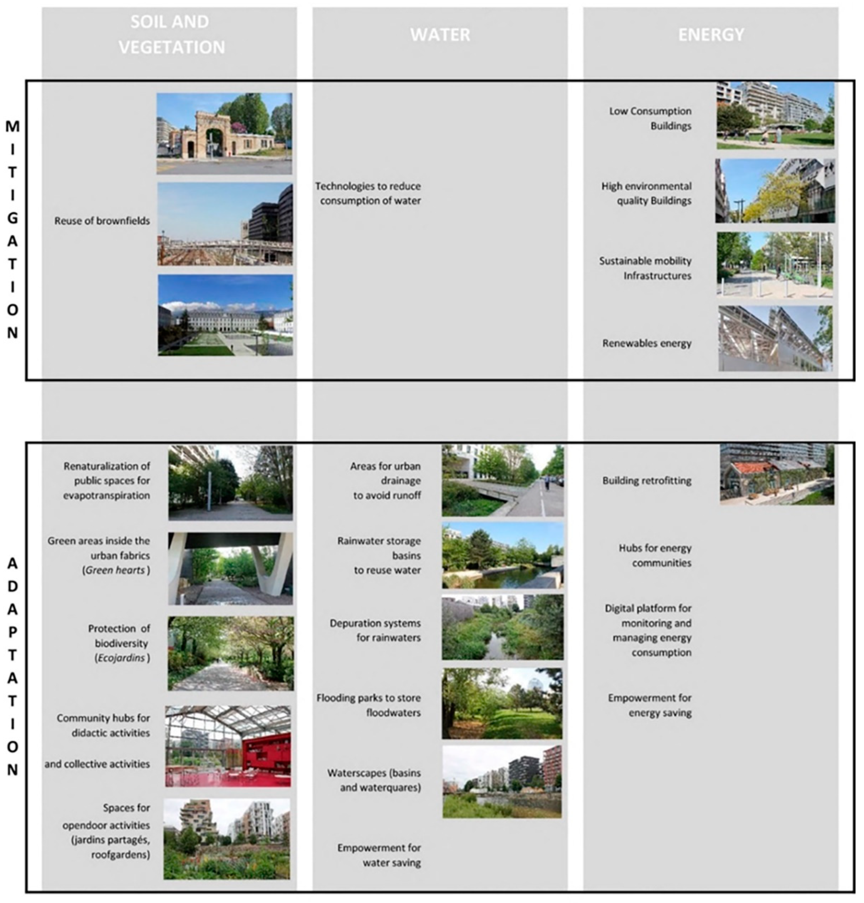
Table 1.
Literature review on urban resilience definition. Source: Authors’ elaboration (2022) from the literature review [24,26,27,28].
| Source | Year | Definition |
|---|---|---|
| Resilience Alliance [26] | 2007 | Urban resilience is the ability of a city or urban system to absorb disturbance while retaining identity, structure, and key processes |
| Rockefeller Foundation [24] | 2013 | City resilience reflects the overall capacity of a city (individuals, communities, institutions, businesses, and systems) to survive, adapt and thrive no matter what kinds of chronic stresses or acute shocks they experience |
| URBACT [27] | 2016 | Urban resilience is the capacity of urban systems, communities, individuals, organisations, and businesses to recover or maintain their function and Thrive in the aftermath of a shock or a stress, regardless its impact, frequency, or magnitude |
| UN-Habitat [28] | 2018 | Urban resilience is the ability of any urban system, with its inhabitants, to maintain continuity through all shocks and stresses, while positively adapting and transforming toward sustainability |
Table 2.
Literature review on eco-districts and emblematic case studies illustrated in the cited publications. Source: Authors’ elaboration (2022) from scientific literature [33,36,37,38,39,40,41,43,44,45].
| Eco-Districts | 1 [33] | 2 [36] | 3 [37] | 4 [38] | 5 [39] | 6 [40] | 7 [41] | 8 [42] | 9 [43] | 10 [44] | |
|---|---|---|---|---|---|---|---|---|---|---|---|
| GWL Terrein (Amsterdam) | 1998 | ● | ● | ||||||||
| Bo01 (Malmö) | 2001 | ● | ● | ● | ● | ● | ● | ● | ● | ||
| Kreuzberg (Berlin) | 2001 | ● | ● | ||||||||
| Bed Zed (London) | 2002 | ● | ● | ||||||||
| Vesterbro (Copenhagen) | 2004 | ● | ● | ||||||||
| Trinitat Nova (Barcelona) | 2006 | ● | ● | ||||||||
| Vauban (Freiburg) | 2006 | ● | ● | ● | ● | ● | |||||
| Hammarby Sjöstad (Stockholm) | 2006 | ● | ● | ● | ● | ||||||
| Zac de Bonne (Grenoble) | 2008 | ● | ● | ||||||||
| Augustenborg (Malmö) | 2009 | ● | ● | ||||||||
| Ile de Nantes Malakoff (Nantes) | 2010 | ● | ● | ||||||||
| Royal Seaport (Stockholm) | 2010 | ● | |||||||||
| Ginko (Bordeaux) | 2012 | ● | ● | ||||||||
| Claude Bernard (Paris) | 2016 | ● | ● | ||||||||
| Saint-Ouen (Paris) | 2016 | ● | ● | ● | |||||||
| Clichy-Batignolles (Paris) | 2019 | ● | ● | ● |
Table 3.
Environmental topics in the evolution of the Laws Grenelle and Calls EcoQuartiers. Source: Authors’ elaboration from literature review [48,49,51].
| 2007 | 2009–2010 | 2009 | 2011 | 2013 | 2014–2016 | 2017–2018 |
|---|---|---|---|---|---|---|
| Conference Grenelle de l’environnement. Introduction of guidelines on EcoQuartiers | Law Grenelle I-II 3.08.09 art.7 Realisation de plusieurs EcoQuartiers | First Call Grid of 25 goals No mention of “climate change” and “resilience” | Second Call Grid of 20 goals introducing “climate change” Projects characterized by water management and heat island but few consider “resilience” | Third Call Grid of 20 commitments including goal including one climate change and risks issues | Fourth Call Grid of 20 Commitments | Fifth Call Grid of 20 commitments |
Table 4.
The 20 “engagements”. Source: http://www.ecoquartiers.logement.gouv.fr/20-engagements/referentiel/ (accessed on 1 May 2022).
Table 4.
The 20 “engagements”. Source: http://www.ecoquartiers.logement.gouv.fr/20-engagements/referentiel/ (accessed on 1 May 2022).
| Approach and Process | Living Environment and Uses | Territorial Development | Environment and Climate |
|---|---|---|---|
| Carry out projects that meet the needs of all by relying on the resources and constraints of the territory | Work as a priority on the existing city and propose an appropriate density to fight against the artificialization of soils | Contribute to local, sustainable, balanced, social, and inclusive economic development | Propose an urban planning that anticipates and adapts to climate change and risks |
| Formalize and implement a management process and shared governance | Implement the conditions for living together and solidarity | Promote the diversity of functions and their proximity | Aim for energy sobriety, the reduction of CO2 emissions and the diversification of sources in favour of renewable and recovered energies |
| Integrate the financial dimension throughout the project in a global cost approach | Implement healthy urban planning to ensure a safe and healthy living environment | Optimize the use of resources and develop local sectors and short circuits | Limit the production of waste, develop and consolidate recovery and recycling sectors in a logic of circular economy |
| Take into account the practices of users and the constraints of managers in the design choices throughout the project | Implement a quality of life that reconciles intensity, living well together and quality of the environment | Promote active modes, public transport and alternative travel offers to decarbonize mobility | Preserve water resources and ensure qualitative and economical management |
| Implement evaluation and continuous improvement procedures | Enhance the natural and built heritage, the history, and the identity of the site | Promoting the digital transition in favour of the sustainable city | Reserve, restore, and enhance biodiversity, soils, and natural environments |
Table 5.
The number of EcoQuartiers through the different stages of the labelling (May 2022). Source: http://www.ecoquartiers.logement.gouv.fr/20-engagements/chiffres-cles/ (accessed on 19 June 2022).
Table 5.
The number of EcoQuartiers through the different stages of the labelling (May 2022). Source: http://www.ecoquartiers.logement.gouv.fr/20-engagements/chiffres-cles/ (accessed on 19 June 2022).
| Stages of the Labelling | Number of Projects |
|---|---|
| ÉcoQuartiers Stage 4 | 17 |
| ÉcoQuartiers Stage 3 | 74 |
| ÉcoQuartiers Stage 2 | 210 |
| ÉcoQuartiers Stage 1 | 380 |
Table 6.
The number of EcoQuartiers through the different stages per year from 2013 to 2021 (May 2022). Source: http://www.ecoquartiers.logement.gouv.fr/20-engagements/chiffres-cles/ (accessed on 19 June 2022).
Table 6.
The number of EcoQuartiers through the different stages per year from 2013 to 2021 (May 2022). Source: http://www.ecoquartiers.logement.gouv.fr/20-engagements/chiffres-cles/ (accessed on 19 June 2022).

Table 7.
Zac de Bonne. Source: Authors’ elaboration (2022) based on data from the site http://www.ecoquartiers.logement.gouv.fr (accessed on 19 June 2022).
Table 7.
Zac de Bonne. Source: Authors’ elaboration (2022) based on data from the site http://www.ecoquartiers.logement.gouv.fr (accessed on 19 June 2022).
| Région | Auvergne-Rhône-Alpes |
| Département | Isère |
| Maîtrise d’ouvrage | SAGES |
| Type de projet | Renouvellement urbain—reconversion d’une caserne militaire |
| Maîtrise d’œuvre | Christian Deviliers, Aktis Architecture, AMO: Énertech, Terre-Éco, Agence Locale de l’Énergie |
| Partenaires | OPAC 38, GEG, EDF, Grenoble Alpes Métropole |
Table 8.
The projects. Source: Authors’ elaboration (2022) based on data from the site http://www.ecoquartiers.logement.gouv.fr (accessed on 19 June 2022).
Table 8.
The projects. Source: Authors’ elaboration (2022) based on data from the site http://www.ecoquartiers.logement.gouv.fr (accessed on 19 June 2022).
| Surface Area | 8.5 ha |
| Housing | 1100 housing units (40% social housing) |
| Services | Primary school, care homes, public swimming pool, students’ residences |
| Activities | Cinema, hotel, offices |
| Urban Green Areas | 3.5 ha |
| Parking | 1/housing unit, 0.8/HS, underground |
Table 9.
Zac des Docks. Source: Authors’ elaboration (2022) based on data from the site http://www.ecoquartiers.logement.gouv.fr (accessed on 19 June 2022).
Table 9.
Zac des Docks. Source: Authors’ elaboration (2022) based on data from the site http://www.ecoquartiers.logement.gouv.fr (accessed on 19 June 2022).
| Région | Île-de-France |
| Département | Seine-Saint-Denis |
| Maîtrise d’ouvrage | Ville de Saint-Ouen, Séquano Aménagement |
| Type de projet | Renouvellement urbain—reconversion de friche industrielle |
| Maîtrise d’œuvre | Agence Makan Rafatdjou, Agence Reichen & Robert & Associés, Agence TER, Berim, Biotope |
| Partenaires | EPFIF, Ville de Paris, Nexity |
Table 10.
The project. Source: Authors’ elaboration (2022) based on data from the site http://www.ecoquartiers.logement.gouv.fr (accessed on 19 June 2022).
Table 10.
The project. Source: Authors’ elaboration (2022) based on data from the site http://www.ecoquartiers.logement.gouv.fr (accessed on 19 June 2022).
| Surface Area | 100 ha |
| Housing | 443,000 mq |
| Services | 15,600 mq |
| Activities | 300,000 mq + 68,000 mq |
| Urban Green Areas | 12 ha |
| Parking | 52,000 mq |
Table 11.
Ile Seguin-rives de Seine. Source: Authors’ elaboration (2022) based on data from the site http://www.ecoquartiers.logement.gouv.fr (accessed on 19 June 2022).
Table 11.
Ile Seguin-rives de Seine. Source: Authors’ elaboration (2022) based on data from the site http://www.ecoquartiers.logement.gouv.fr (accessed on 19 June 2022).
| Région | Île-de-France |
| Département | Hauts-de-Seine |
| Maîtrise d’ouvrage | Ville de Boulogne Billancourt, SAEM Val de Seine Aménagement |
| Type de projet | Renouvellement urbain—reconversion de friche |
| Maîtrise d’œuvre | Patrick Chavannes (Urbaniste—Coordonnateur) |
| Partenaires | Organismes HLM, promoteurs privés, ADEME, CDC |
Table 12.
The project. Source: Authors’ elaboration (2022) based on data from the site http://www.ecoquartiers.logement.gouv.fr (accessed on 19 June 2022).
Table 12.
The project. Source: Authors’ elaboration (2022) based on data from the site http://www.ecoquartiers.logement.gouv.fr (accessed on 19 June 2022).
| Surface Area | 671,258 mq |
| Housing | 5000 units, one-third social housing |
| Services and Activities | 76,810 public equipment, activities, commercial, 230,068 mq offices |
| Urban Green Areas | 7 ha |
Table 13.
Clichy-Batignolles. Source: Authors’ elaboration (2022) based on data from the site http://www.ecoquartiers.logement.gouv.fr (accessed on 19 June 2022).
Table 13.
Clichy-Batignolles. Source: Authors’ elaboration (2022) based on data from the site http://www.ecoquartiers.logement.gouv.fr (accessed on 19 June 2022).
| Région | Île-de-France |
| Département | Paris |
| Maîtrise d’ouvrage | Ville de Paris, Paris et Métropole Aménagement |
| Type de projet | Renouvellement urbain—reconversion de friche |
| Maîtrise d’œuvre | Atelier François Grether, agence Jacqueline Osty, Omnium Général Ingénierie (VRD), Inddigo/ATM (AMO DD), Une autre Ville (AMO pilotage environnemental) |
| Partenaires | DRPJ, EPPJP, RATP, SAEMES, SNCF/RFF, STIF, Bouygues, Bouwfonds Marignan, COGEDIM, EMERIGE, APUR |
Table 14.
The project. Source: Authors’ elaboration (2022) based on data from the site http://www.ecoquartiers.logement.gouv.fr (accessed on 19 June 2022).
Table 14.
The project. Source: Authors’ elaboration (2022) based on data from the site http://www.ecoquartiers.logement.gouv.fr (accessed on 19 June 2022).
| Surface Area | 54 ha |
| Housing | 3400 |
| Services and Activities | 38,000 mq services; commercial and offices 140.000 mq + 31.000 mq; Paris Court and Regional Directorate of the Judicial Police 120,000 mq |
| Urban Green Areas | 10 ha |
Table 15.
The assessment grid. Source: Authors’ elaboration (2022) from the analysis of the 4 case studies, data based on http://www.ecoquartiers.logement.gouv.fr and on survey/on-site visit (accessed on 19 June 2022).
Table 15.
The assessment grid. Source: Authors’ elaboration (2022) from the analysis of the 4 case studies, data based on http://www.ecoquartiers.logement.gouv.fr and on survey/on-site visit (accessed on 19 June 2022).
| ZAC de Bonne | ZAC des Docks | ZAC Trapèze | ZAC Clichy Batignolles | |||
|---|---|---|---|---|---|---|
| MITIGATION | WATER | Technologies for the reduction of potable water | ||||
| SOIL AND VEGETATION | Reuse of brownfields (former industrial, infrastructure and military areas) to limit land consumption | |||||
| ENERGY | Buildings with Bâtiments Basse Consommation (BBC) Certification | |||||
| Building with Haute Qualité Environmentale (HQE) Certification | ||||||
| Infrastructure for sustainable mobility (railways, pedestrian paths, cycle systems, carpooling, zone 30) | ||||||
| Renewable energy production systems (heating: geothermal, biomass, photovoltaic; cooling: river geothermal) | ||||||
| ADAPTATION | WATER | Rainwater harvesting system | ||||
| Water purification and reuse systems (filtration, run-off purification, use for irrigation, storage in the park) | ||||||
| River expansion basins | ||||||
| Drains and tanks for the lamination of rainwater to avoid run-off | ||||||
| Semi-natural and built waterscapes | ||||||
| Empowerment activities to limit water consumption | ||||||
| SOIL AND VEGETATION | Community hubs for thematic conferences, didactic workshops for children, urban walks | |||||
| Extraordinary equipment for outdoor activities (roof-garden, jardins partagés, educational greenhouses) | ||||||
| Green areas inside the urban fabric (open block) | ||||||
| Renaturalized areas | ||||||
| Biodiversity protection (Ecojardin recognized by the Agence régionale de la biodiversité) | ||||||
| ENERGY | Reuse of existing buildings with energy efficiency (retrofitting) | |||||
| Empowerment activities to limit energy consumption | ||||||
| Community hubs | ||||||
| Digital platforms for the management and monitoring of consumption |
Table 16.
The eco-district framework. Source: Authors’ elaboration (2022) from the results of the questionnaires (2022).
Table 16.
The eco-district framework. Source: Authors’ elaboration (2022) from the results of the questionnaires (2022).
| PROFILE OF THE USERS | AGE | 0–20 | 20–30 | 30–50 | Over 50 |
| % | 30% | 0% | 60% | 10% | |
| Gender | F | M | |||
| % | 70% | 30% | |||
| Inhab. | Eco-district | Municipality | Other | ||
| 20% | 80% | 0% | |||
| GENERAL QUESTIONS | Do you know that you are in an eco-district? | YES | NO | ||
| 100% | 0% | ||||
| How often you use the park? | Every week | Once/month | Sometimes | Never | |
| % | 40% | 40% | 20% | 0% | |
| What are your means of transport? | Subway | Bicicle | Cars | ||
| % | 60% | 35% | 5% | ||
| LOCAL ENGAGEMENT AND ACTIVE PARTICIPATION | Are you engage in local active participation? | YES | NO | ||
| 50% | 50% | ||||
| Have you attended local events related to environment and climate change? | Often | Once | Never | ||
| % | 20% | 30% | 50% | ||
| If yes, do you attend the activities of the local hubs? | YES | NO | |||
| % | 100% | 0% | |||
| SMART TECHNOLOGIES | Are you engaged in local active participation? | YES | NO | ||
| 50% | 50% | ||||
| Do you use applications/smart technologies in everyday life? | YES | NO | |||
| % | 90% | 10% | |||
| Do you use application for sustainable lifestyles? | YES | NO | |||
| % | 10% | 90% |
Table 17.
The eco-district framework. Source: Authors’ elaboration (2022) from the analysis of the 4 case studies, data based on http://www.ecoquartiers.logement.gouv.fr and on survey/onsite visit (accessed on 19 June 2022).
Table 17.
The eco-district framework. Source: Authors’ elaboration (2022) from the analysis of the 4 case studies, data based on http://www.ecoquartiers.logement.gouv.fr and on survey/onsite visit (accessed on 19 June 2022).
| Concept | Definition | |
|---|---|---|
| MITIGATION | ||
| Brownfields | S | Eco-district must overcome land consumption and be localized in dismissed areas to be regenerated (military areas, ports, industrial areas, dismissed infrastructures) in order to foster urban density, land reclamation and depaving |
| Sustainable mobility infrastructure | E | Eco-district must be based on sustainable mobility combining rapid public transport with soft and micro-mobility in order to mitigate the greenhouse gases |
| BBC | E | The Low Energy Consumption Building (BBC) is a label awarded to buildings that have low energy consumption for heating, air conditioning, lighting, domestic hot water (ECS), and ventilation |
| HQE | E | HQE is the French certification awarded to building construction and management as well as urban planning projects. HQE promotes best practices, sustainable quality in building projects, and offers expert guidance throughout the lifetime of the project. https://www.behqe.com/ (accessed on 19 June 2022) |
| Renewable energy sources | E | Renewable energy is energy that comes from natural sources or processes that are constantly replenished. Renewable energy can be used for electricity generation, space and water heating and cooling, and transportation. The main sources used in eco-districts are photovoltaic and geothermal energy |
| ADAPTATION | ||
| Open blocks | S | The open block differs from the common block by its shape, which allows it to be crossed and to host a “green heart”. Theorized by architect-urban planner Christian de Portzamparc, the open block is defined by a “full” side, autonomous and yet varied, and an “empty” side, open and bright. The morphology enables the articulation of public, common and private spaces, contributing to the continuity of the green network and to the implementation of nature-based solutions |
| Nature-based solutions for water management | W | The urban green surfaces must contribute to the mitigation of risks related to water cycles, with particular reference to extremes events (floods) and to the adaptation to the uncertainty of the levels of rainwaters and river flows |
| Eco-jardins | S | The Eco-Jardin label is a communication and recognition tool for the public, maintenance teams and elected officials. The basic principles of the label are engagement in a global approach to ecological management, audits carried out by competent and independent external bodies and based on common evaluation grids, commitment to a process of continuous improvement that involves the protection of biodiversity, the improvement of the ecological functions of soils, water management, and eco-friendly materials. The framework supports the strengthening of ecological connections of the site with the territorial and environmental context. The label is released in relation to quantitative and qualitative criteria that relate to the quality of botanical heritage and management practices |
| Jardin partagés | S | The urban green areas must promote the open-door social activities in order to strength community relations, reduce consumptions of energy and promoting eco-friendly lifestyles |
| Community hubs | S | Community hubs act as public equipment aimed at strengthening eco-friendly lifestyles and awareness on climate changes challenges |
| Digital platforms | E | Digital platforms represent important tools for the monitoring of water and energy consumptions and enable the implementation of “energy communities” and “waste communities” |
Table 18.
Potentials and limits of eco-districts practices. Source: Authors’ elaboration (2022) from the analysis of the 4 case studies, data based on http://www.ecoquartiers.logement.gouv.fr and on survey/onsite visit (accessed on 19 June 2022).
Table 18.
Potentials and limits of eco-districts practices. Source: Authors’ elaboration (2022) from the analysis of the 4 case studies, data based on http://www.ecoquartiers.logement.gouv.fr and on survey/onsite visit (accessed on 19 June 2022).
| ECO_DISTRICTS | POTENTIALS | LIMITS |
| Integrated design approach | Costs of the projects | |
| Replicable design solutions | Greentrification | |
| Dissemination of practices | Standardization | |
| Quality of innovation | Not mandatory labelling |
Publisher’s Note: MDPI stays neutral with regard to jurisdictional claims in published maps and institutional affiliations. |
© 2022 by the authors. Licensee MDPI, Basel, Switzerland. This article is an open access article distributed under the terms and conditions of the Creative Commons Attribution (CC BY) license (https://creativecommons.org/licenses/by/4.0/).
Share and Cite
MDPI and ACS Style
Poli, I.; Ravagnan, C.; Ricci, L. A Planning Framework for Urban Resilience toward Climate Adaptation and Mitigation: Potentials and Limits of “Eco-Districts”. Urban Sci. 2022, 6, 49. https://doi.org/10.3390/urbansci6030049
AMA Style
Poli I, Ravagnan C, Ricci L. A Planning Framework for Urban Resilience toward Climate Adaptation and Mitigation: Potentials and Limits of “Eco-Districts”. Urban Science. 2022; 6(3):49. https://doi.org/10.3390/urbansci6030049
Chicago/Turabian StylePoli, Irene, Chiara Ravagnan, and Laura Ricci. 2022. "A Planning Framework for Urban Resilience toward Climate Adaptation and Mitigation: Potentials and Limits of “Eco-Districts”" Urban Science 6, no. 3: 49. https://doi.org/10.3390/urbansci6030049