Images for Deconstructing the Complexity and Images for Constructing the Collective Imagination in the Case of the Alpine Landscape. A Selected Overview †


Department of Architecture and Design, Politecnico di Torino, 10129 Torino, Italy
†
Presented at the International and Interdisciplinary Conference IMMAGINI? Image and Imagination between Representation, Communication, Education and Psychology, Brixen, Italy, 27–28 November 2017.
Proceedings 2017, 1(9), 957; https://doi.org/10.3390/proceedings1090957
Published: 16 November 2017
(This article belongs to the Proceedings of Proceedings of the International and Interdisciplinary Conference IMMAGINI? Brixen, Italy, 27–28 November 2017.)
Abstract
:The process of touristic exploitation of the Alps is strictly correlated to the collective imagination that have been constructed in the last two centuries. In this process images have been and are used for deconstructing the complexity of the Alpine environment (e.g., the orography) and for constructing the collective imagination. The article propose a selected overview of graphic modes developed specifically for the deconstruction of the complex alpine morphology, modes that led to some stereotyped images which are useful to understand the material transformation of the Alpine territory.
Keywords:
landscape; panorama; representation; deconstruction; intangible heritage; digital models; AlpsPublished: 16 November 2017
1. Introduction
The vast majority of human people on Earth knows the high mountains only through images [1]. And, moreover, the mountains are “constructed” through images: “as paradoxical as it may seem at first glance, the Alps, as well as today we know them and perceive them, have not always existed”. They were “constructed” through a twofold process: the scientific and artistic knowledge that led to the construction of a collective imagination, and the material transformation of the Alpine territory through human artifacts [2]. It is important to underline that such material transformation was and is carried on according to the collective imagination [3], that—mainly—is based on and conveyed through images.
The history of the alpine iconography dates from the XVIII century, when the Alps became a topic of great interest for scientists and artists [1] (p. 118). Before that period, the Alps were mainly unknown, as it is clear looking at cartographic representations [4]. Starting from the end of the XVIII century, naturalists, geologists, surveyors, cartographers and then painters and illustrators developed specific modes of representation in order to study the Alps [2,4,5]. In fact the mountainous environment is characterized by a geomorphological complexity superior to other environments, and the representation of complex systems requires a process of simplification, as stated by the Nobel Prize winner Herbert Simon [6] (p. 215). For this reason images, geometry, and representation techniques were then used to investigate—through deconstruction operations—the complex systems of the Alpine environment.
In this regard the theorizations by Eugene Viollet-le-Duc on the possibility of analyzing the morphology of the mountain massifs starting from the simple geometries of crystals are emblematic [7], and moreover are conceptually similar to modern techniques, such as the procedural terrain modeling based on various geometric generation methods, from fractals to evolutionary algorithms [8] (Figure 1).
The article aims to investigate techniques and graphic devices developed specifically for the deconstruction of the complex geometries that we can find in mountain environments. Such techniques and graphic devices include for example the positioning of the points of view, the decomposition of the views in different planes, the thematizations, the analysis of building types, the horizontal and vertical sections used in cartography, in the projects of dams, roads and infrastructure.
The original contribution of this overview lies in the selection criteria of graphic works and representation techniques, in accordance with the specific theme of research of images that were produced for deconstructing the complexity of the Alpine environment.
Starting from this preliminary investigation, the article also aims to explain which of these modes of representation have produced images that characterize specifically the Alpine world, which therefore constitute a specific medium in the construction of the collective imagination of the Alps.
In fact, the alpine environment as a whole, declined both in terms of landscape and architecture, was and still is often represented through stereotyped images, so that these images appear to be fundamental in the “construction of the Alps”, that is the construction of an idealization of the mountain environment that is the basis of the material transformation of the territory [2,3,10].
The bases of the mode of production of stereotyped images, which are still commonly used today, were laid and codified since the nineteenth century, or even the end of the eighteenth. Among them, we can highlight:
- the circular panoramas of mountain peaks, based on vertical projections—starting from the very first drawn by Hans Konrad Escher von der Linth in 1792 [11,12]—with the toponymic detection of the peaks, now resumed by applications of Augmented Reality for Mountain Peak Detection in images from mobile devices [13];
- the images of romantic taste, that, according to the aesthetic category of sublime, are characterized by the artificial accentuation of dizzying features such as height, slopes, depths, born in the romantic period but still frequently used in cinematography and video games with the creation of fantastic digital settings;
- the picturesque images of alpine buildings and villages, based on the complementary contrast procedure between natural and artificial characters [2], procedure that is commonly used also nowadays in the creation of advertising pictures for the promotion of mountain resorts.
- These modes were extensively used even in the XX century, even in hybrid forms, such the production of deformed panoramic views for the promotion of ski resorts [14].
The article therefore intends to use consolidated methodologies for analyzing image-building parameters (projection methods, projection elements, plan decomposition, graphic arts) in order to provide a critical essay on the recurring modes for the elaboration of conceptualizations about the mountain environment, and their permanence in contemporary communication tools (augmented reality, cinematography, visualization tools on a territorial scale).
2. Deconstruction and Representation of Alpine Orography
“The first thing that struck me in the spectacle of the multitude of highest summits under my eyes from the top of the highest of them, was the disorder that reigns in their disposition”. These words of Horace Benedict De Saussure, scientist and father of mountaineering, in the report of the third absolute ascension of Mont Blanc on 3 August 1787, are emblematic: they denounce the difficulty of perceiving the complexity of the morphology of mountainous systems and also the importance of a peculiar feature of the representation system—the position of the point of view—to resolve the perception of chaos.
The account of the great Illuminist scientist implies ante litteram the fundamental relationship between complex systems and representation, underlined by Simon: “How complex or simple a structure is depends critically upon the way in which we describe it” and upon the way of simplification of its description [6].
2.1. Alpine Cartography
The first scientific graphic tool that was developed to investigate the complexity of the alpine orography were maps. The history of the cartographic survey and representation is an established research theme, and is well known, and some research focused specifically on mountain cartography. For example [4] focuses on the period from the origins (XVI century) to the XIX century, while [15] on the XIX and XX century. For such reason this section gives only a brief general overview pointing out the main topics.
According to [4,16] it is possible to classify the progressive increase of information about the Alps and the progressive refinement of representation of orographic features (Figure 2):
- XVI century—phase of representation of the main passes: the mountains are of no interest, and they are not represented in the maps; the maps individuate only the main Alpine passes and only occasionally the roads;
- XVII century—phase of detection of roads and the main mountains: as a general rule the main mountains are named, but the depiction is only symbolic.
- XVIII century—phase of the survey of the territory: the first triangulated surveys are limited to the planes and the most accessible hills, while some regional mapping campaigns generated small scale mountain maps, mainly for military purposes. Although the graphics of these abstract landscape representations seemed rather clumsy, the accuracy of the geometric positions of topographic objects was nevertheless in the range of decameters to kilometers [15];
- XIX century—phase of the systematic recognition of the Alps: the first triangulated survey of the Alps dates from 1821. The triangulation using new theodolites allowed to survey and map average-sized European countries at medium scales without major distortions and was the base for some great national mapping projects. In this context the entire Swiss Alps were measured and drawn in the Swiss National map—also known as “Dufour map”—at the scale of 1:100,000; that map set the standard in terms of representation of mountainous features for more than 100 years (was only replaced in the 1960s). At the end of the century remains few zones to be surveyed (that will be completely represented with the advent of aerial photogrammetry at the beginning of the XX century);
- first half of XX century—phase of systematic topographic mapping at bigger scale: in the first half of the 20th century, among new and more precise geodetic instruments and methods, the systematic recording and compilation of terrestrial and aerial images was a revolutionary improvement for updating topographic mountain maps. Changes of the man-made infrastructure or glacier movements could be detected easily, and represented in more precise maps (the European countries of the Alpine region have uniform map series with complementary scales, e.g., 1:100,000, 1:50,000 and 1:25,000).
- end of XX century, until now—phase of digital mountain cartography: In the second half of the 20th century, mountain cartography was fundamentally influenced by two other developments: the success of computerization and the broad availability of remote sensing images. This new, digital infrastructure supports a broad scope of new cartographic representations. Improved computer technologies and changed habits of map users now lead towards the integration of multimedia technologies and interactivity in order to provide theme-specific and user-centred presentations. With web-interface 3D terrain models, such as Google Earth or the interactive Atlas of Switzerland, the user can choose the preferred data layers and will add own topographic or textual layers. The desired section of the landscape, the view settings, and finally the output format can be deliberately chosen. Using such tools, the map user creates his own personalised representations, which can, e.g., be individually used for mountain hikes or as a planning instrument.
The possibility for everyone to produce its personal exploration of the orography of a mountain region using an interactive 3D model sets a totally new attitude; before that, the comprehension of a certain region was constructed through a set of default images: cartographic maps with predefined content, panoramic views from notorious points.
2.2. Panoramic Views
In 1776 De Saussure invented a particular view in order to provide an analytical description of all the mountains that he observed from a panoramic point of view, the top of Mont Buet near the Mont Blanc massif: a circular view, that according to the description of the building process is obtained as juxtaposition of many views taken from the same point of view but with a 360 degree rotation of the direction of view; then the views are all revolved on the same plane, rotated and arranged along a circumference and linked in only one drawing [17] (pp. 496–498).
This procedure was one of the experiments of representation of ample parts of the territory, that was an emerging problem in the XVIII century, and the mountains of Switzerland were an early case-study for experimentations by scientific drawers, starting from the surveys of the mathematician J.B Micheli du Crest in his Prospect Géometrique des montagnes in 1753 [11] (pp. 30–31).
Even if the technique of de Saussure is used until nowadays in some panels on top of panoramic points in the Alps, it was surpassed by the vertical panorama. The name was introduced approximately in 1790 to identify a new type of painting that was patented some years before (1787) by the Scottish painter Robert Barker. In this case the panorama is a central projection on a vertical cylindrical surface, extended horizontally to 360 degree around the center of projection. The very first panorama of the Alps, according to this technique, was painted very early by Hans Konrad Escher von der Linth in 1792 [11,12], and this practice became very popular.
The panorama is of particular importance for the birth of a collective imagination about the Alps. In fact, unlike the most conventional paintings destined to a private fruition, the panorama became a kind of pictorial product for the masses of the European cities. Starting from his inventor, the panorama was not only a painting, but a complex device of communication: these very big paintings required special buildings, designed in order to optimize the light, the point of observation, the fruition of the painting by masses of customers. From this point of view it has more similitudes with the cinema that with pictorial art. The panoramas of the Alps were some of the most important ones seen in the European and the North American cities, such as the “Panorama of Bernese Alps” that was prepared for the International Exposition in Chicago of 1893 [18].
The panoramas set the most important viewpoints of the Alps in the collective imagination of a widespread mass of urban people; as a result some sites arose in the collective imagination and laid the basis for the touristic development of some towns [2]. After the success of the major installations in many cities, the panoramic drawing was widely used in guidebooks, in order to provide a mean, easier to read than a topographic map, to identify the peaks. As in the case of the big installations, even in these examples the user cannot choose the point of view, that on the contrary is chosen by the drawer among the most famous ones. The rise of the first touristic sites was driven by the images of a limited number of well-known sites (e.g., Chamonix, Saint-Moritz, etc.)
The use of panoramic views for a user-friendly detection of peaks is common even nowadays, with web interfaces (e.g., Google Earth, PeakFinder [19], Atlas of Switzerland [20], etc.) and with the implementation of Augmented Reality applications on mobile devices. The web interfaces allow every user to create his own panoramic view, setting the position of the point of view, both in terms of position geographical position and height. The outdoor augmented reality applications exploit the position and orientation sensors of mobile devices to estimate the location of the user and its field of view so as to overlay such view with information pertinent to the user’s inferred interest. In general terms these solutions are finding a promising application in the tourism sector, where they replace traditional map-based interfaces with a more sophisticated user experience whereby the user automatically receives information based on what he is looking at, without the need of manual search. In the particular case of mountain environment, some applications that are now popular (e.g., PeakFinder App) [19] or under development (e.g., SnowWatch) [13] are outdoor mobile AR application for the automatic annotation of in-view mountain peaks with geographical meta-data (peak name, altitude, distance from viewer, etc.).
3. Construction of the Collective Imagination of the Alps
The human modification of the Alps, a unique region in the centre of Europe, became highly relevant in the last two centuries, so that some authors [2,21] define this phenomenon as “the construction of the Alps”. In order to understand and manage the modification of the Alps, it is necessary to understand the collective imagination about the alpine environment [3,10]. The modern conceptualization of the alpine environment was set in the period between the “discovery” of the Alps by the urban and preindustrial society at the end of the XVIII century, and the industrial exploitation of the alpine environment in the XIX and XX century. According to [2] in that period was born and grew an idea of mountain that was strictly related to the romantic “picturesque” image, that is still strong today.
The touristic exploitation, the growth of some touristic alpine cities, the foundation of ski resorts, the infrastructures, but even the most recent ecologist attitude of preservation are in many manners related to the collective imagination. And, even after two centuries, such collective imagination has its foundations in the aesthetic categories of “sublime” and “picturesque” of the Romantic period.
Deformation and Perception. Sublime Images
Starting from the XVIII century there was a rich philosophical discussion about the aesthetics in general and the “sublime” category in particular [22,23]. From the very beginning a long aesthetical tradition pointed out the correlation between the Alps and the Sublime. In [2] (pp. 79–80) a brief summary of the first dissertations in aesthetics and literature is given. Even in more recent years many researches are focused on the relationship of sublime and alpine landscape [24,25,26,27,28].
The first philosophical definitions of Sublime are related to the emotional responses to terror, to something that is so large that it overwhelms human imagination or to the awareness of our physical powerlessness in the face of nature’s might. Burke defines terror as a ruling principle: “Whatever is in any sort terrible, or conversant about terrible objects, or operates in a manner analogous to terror, is a source of the Sublime” [22] (p. 47), while Kant on the contrary asserts that we have the feeling of the dynamically sublime when we experience nature as fearful while knowing ourselves to be in a position of safety and hence without in fact being afraid [23].
According to the aesthetical definitions the painters of the XIX century developed modes and techniques in order to obtain the effect of arising a sense of horror and/or overwhelming nature. Such modes were focused on enhancing the saliency of the relief [28], for example emphasizing the disproportion between the big mountains and the small human figure, emphasizing the disruptive force of natural phenomena (thunderstorm, avalanches), or the perceived height of peaks and cliffs. In some case such effects were obtained not only through pictorial effects (the dramatic use of lights and shadows, for example) but even with pictorial artefacts and deformations of the relief, in order to enhance the impression of height, the verticality of faces, cliffs, slopes (Figure 3).
Such artefacts are common even today in the production of images of mountain environment for entertainment. The 3D models and views of mountainous terrain in animation movies, such as Frozen (Walt Dysney Animation Studios, 2013), continue a tradition two centuries long of delivering sublime images, and for this reason adopt many modeling and pictorial artefacts: deformation of the terrain features in order to exaggerate the impression of height and verticality of peaks, the introduction of small human figures compared to the dimension of the mountainous masses, the choice of “dramatic” point of views such as a low point of view under a high cliff, snow thunderstorm, and the movement of snow. The Figure 4 shows the permanence of suggestions of Sublime from 19th century art into a frame of a 21st century animation movie.
4. A Conclusion: Imaginative and Physical Construction of the Alpine Environment
In the last two centuries the Alps have been heavily transformed by man, certainly more than any other mountain range in the world [10]. The history of the physical construction of the Alps is deeply documented in [2,3]: road and transportation infrastructures, mining and industrial facilities, hydroelectricity infrastructure, mountain cities, buildings, touristic facilities, ski resorts, etc.
This last conclusive overview regards the infrastructure for the touristic exploitation, and in particular the role of some images in the process of imaginative and physical construction of ski resorts and other touristic structures.
In fact it is possible to see an interesting correlation between the physical adjustment of the terrain in the construction of ski resorts and the graphic deformation of the terrain in the panoramic maps illustrating the same ski resorts.
Panoramic maps—also called panorama maps—are aerial view paintings of landscapes, commonly used to present terrain information to non-expert viewers [31]; in this case the term panorama is derived from the original term of Baker, but with some differences: panoramic maps are oblique perspectives of any angle and they often are not topographically accurate [32], since they are not a simple cartographic output but an hybrid product between photography, fine art, cartography [33] (p. 43). Panoramic views are by far the most common type of map used by skiers in ski resorts [14,34]. Trails maps for ski areas are iconic images of the sport of skiing and its relation to the terrain on which ski resorts are built. The development of the maps has paralleled the development of lift-served skiing. The combination of bigger areas to map and an increase in money in the sport led to a shift from simple wayfinding maps to more elaborate mountain portrayals: panoramas respond to the desire for resorts to look impressive to potential visitors. Ski areas often ask for the ski resort to look bigger and for the artist to distort the mountain for this purpose [32] (p. 495). Landscape artists have addressed such challenges by applying local deformation to map objects in hand-painted hiking and skiing panoramas, using painting handcraft techniques in the 20th century [33] and searching for digital techniques nowadays. Some algorithms have been developed to digitally deform the 3D models of terrain: to provide interactive occlusion-free navigation in 3D complex terrain environments by deformation of the elevation only [35] or to imitate the complex techniques hand-painters, such as complex terrain deformations based on progressive bending, multidimensional deformation of control points, rotation [36]; some authors [31] presents methods to automatically produce landscape renderings in the visual style of the panorama based on map surface textures that are generated using perceptual metrics and artistic considerations. A recent research on “Memory, Cognition and Modelling of mountain landscape” [32] is emblematically a study on mental representations for realistic visualization of ski maps and concludes that ski maps “formatted the reading of the mountain of generations of practitioners and tourists” and that even in the adaptation of the panorama to the digital era, the mountain’s operators still wish that ski trails map mostly address a message of vastness, beauty and dreams.
The final thoughts are that there is a strong analogy between the physical modification of the terrain carried on with bulldozers and the perceptual modification of the mountain carried on with marketing images:
- vastness: in the second half on 20th century there was a process of progressive and aggressive enlargement of the main ski resorts [3]; the panoramic images tend to highlight the sense of vastness of the resort deforming the terrain in order to improve the dimensions of the lift-accessed areas in comparison to natural terrain (Figure 5);
- beauty: the panoramic images tend to improve the impression of height and verticality of the most prominent surrounding peaks, deform the terrain in order to depict the most notable natural features (lakes, landmarks, ski-line) and depict an exaggerate snow cover;
- dreams: the marketing promote the stereotyped image of a resort with consistent snow coverage and no obstacles; this is a stereotype that have some consequences in the reality: excavation and transportation of big masses of soil to remove natural obstacles, creation of artificial water reservoirs and plants for the production of artificial snow, etc.
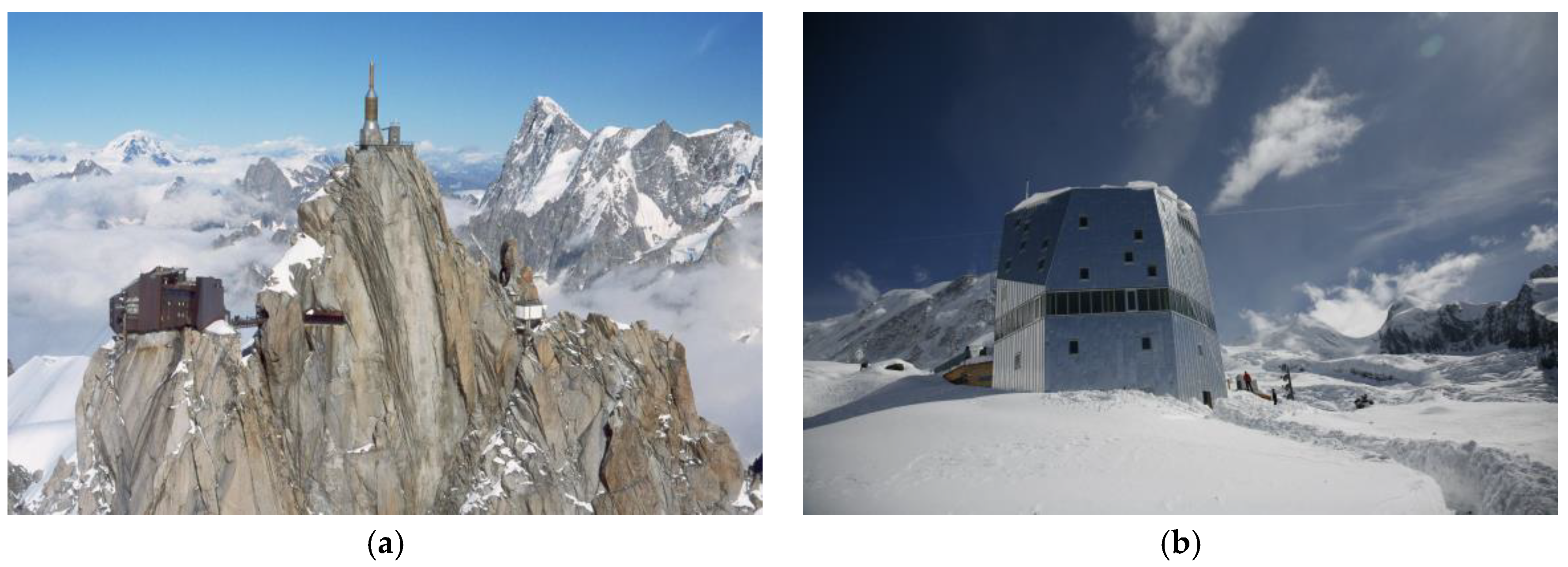
The relationship between the collective imagination and the physical construction is evident in many buildings in the Alps and in the other mountainous ranges in the world (Figure 6 and Figure 7). The location (on prominent or panoramic) points, the shape (enhancing distinctive features of verticality), the materials (glass and metal) used in modern alpine architecture are in many cases reminiscent of tales and sublime images that persist from the romantic period till nowadays.
Conflicts of Interest
The author declares no conflict of interest.
References
- Garimoldi, G. L’immagine contesa. L’iconografia alpina fra belle arti e fotografia. In Le Cattedrali Della Terra. La Rappresentazione Delle Alpi in Italia e in Europa 1848–1918, 1st ed.; Scherini, L., Ed.; Electa: Milano, Italy, 2000; pp. 118–124. [Google Scholar]
- De Rossi, A. La costruzione delle Alpi. Immagini e Scenari del Pittoresco Alpino (1773–1914), 1st ed.; Donzelli: Rome, Italy, 2014. [Google Scholar]
- De Rossi, A. La costruzione delle Alpi. Il Novecento e il Modernismo Alpino (1917–2017), 1st ed.; Donzelli: Rome, Italy, 2016. [Google Scholar]
- Aliprandi, L.; Aliprandi, G. Le Grandi Alpi nella Cartografia 1482–1885. Volume I. Storia della Cartografia Alpina; Priuli & Verlucca: Ivrea, Italy, 2005; Volume 1. [Google Scholar]
- Audisio, A. (Ed.) Immagini e Immaginario Della Montagna. 1740–1840; Museo Nazionale della Montagna: Torino, Italy, 1989. [Google Scholar]
- Simon, H.A. The Sciences of the Artificial, 3rd ed.; The MIT Press: Cambridge, MA, USA, 1996. [Google Scholar]
- Viollet-le-Duc, E.-E. Le Massif du Mont-Blanc, Etude sur sa Constitution Geodesique et Géologique, sur ses Transformations et sur l’état Ancien et Moderne de ses Glaciers; J. Baudry: Paris, France, 1876. [Google Scholar]
- Smelik, R.; de Kraker, K.; Groenewegen, S.; Tutenel, T.; Bidarra, R. A Survey of procedural methods for terrain modelling. In Proceedings of the CASA Workshop on 3D Advanced Media in Gaming and Simulation (3AMIGAS), Amsterdam, The Netherlands, 16 June 2009. [Google Scholar]
- Cordonnier, G.; Braun, J.; Cani, M.P.; Benes, B.; Galin, É.; Peytavie, A.; Guérin, É. Large Scale Terrain Generation from Tectonic Uplift and Fluvial Erosion. Comput. Graph. Forum 2016, 35, 165–175. [Google Scholar] [CrossRef]
- Batzing, W. Le Alpi. Una Regione Unica al Centro Dell’europa; Bollati Boringhieri: Torino, Italy, 2005. [Google Scholar]
- Bordini, S. Storia del Panorama. La Visione Totale Nella Pittura del XIX Secolo; Officina Edizioni: Roma, Italy, 1984. [Google Scholar]
- Brandenberger, R.; Smith, H.A.; Solar, G. Die ersten Panoramen der Alpen. Zeichnungen, Ansichten, Panoramen und Karten. The First Panoramas of the Alps. Drawings, Views, Panoramas and Maps. Hans Conrad Escher von·der Linth; Brandenberger, R., Ed.; Baeschlin: Glarus, Switzerland, 2002. [Google Scholar]
- Fedorov, R.; Frajberg, D.; Fraternali, P. A Framework for Outdoor Mobile Augmented Reality and Its Application to Mountain Peak Detection. In Augmented Reality, Virtual Reality, and Computer Graphics. AVR 2016. Lecture Notes in Computer Science; De Paolis, L., Mongelli, A., Eds.; Springer International Publishing: Basel, Switzerland, 2016; Volume 9768, pp. 281–301. [Google Scholar] [CrossRef]
- Tait, A. Mountain Ski Maps of North America: A Preliminary Survey and Analysis of Style. Cartogr. Perspect. 2010, 67, 5–17. [Google Scholar] [CrossRef]
- Haberling, C.; Hurni, L. Mountain cartography: Revival of a classic domain. ISPRS J. Photogramm. Remote Sens. 2002, 57, 134–158. [Google Scholar] [CrossRef]
- Maps of Switzerland, Swiss Confederation. Available online: https://map.geo.admin.ch (accessed on 20 September 2017).
- De Saussure, H.B. Voyages dans les Alpes, Précédés d’un Essai sur L’histoire Naturelle des Environs de Genève; Samuel Fauche: Neuchatel, Switzerland, 1779; Volume 1. [Google Scholar]
- Anker, V. Dal viandante romantico alla folla dei panorami: Frontiere e ibridazioni nella rappresentazione dello spazio alpestre. In Le Cattedrali della Terra. La Rappresentazione delle Alpi in Italia e in Europa 1848–1918; 1st ed.; Scherini, L., Ed.; Electa: Milano, Italy, 2000; pp. 26–30. [Google Scholar]
- PeakFinder. Available online: https://www.peakfinder.org (accessed on 18 September 2017).
- Atlas of Switzerland. Available online: http://www.atlasderschweiz.ch (accessed on 18 September 2017).
- Franco, C.; Maumi, C. The construction of a territory in the Alps. Infrastructure for mass tourism. Techne—J. Technol. Archit. Environ. 2016, 172–179. Available online: http://www.fupress.net/index.php/techne/article/view/18418/17124 (accessed on 20 September 2017). [CrossRef]
- Burke, E. A Philosophical Inquiry into the Origin of our Ideas of the Sublime and the Beautiful; R. and J. Dodsley: London, UK, 1756. [Google Scholar]
- Ginsborg, H. Kant’s Aesthetics and Teleology. In The Stanford Encyclopedia of Philosophy; Fall 2014 Edition; Zalta, E.N., Ed.; Available online: https://plato.stanford.edu/archives/fall2014/entries/kant-aesthetics/ (accessed on 20 September 2017).
- Nicolson, M.H. Mountain Gloom and Mountain Glory. The Development of the Aesthetic of the Infinite; W. W Norton: New York, NY, USA, 1959. [Google Scholar]
- Hauptman, W. La Suisse Sublime vue par !es Peintres Voyageurs. 1770–1914; Electa: Milano, Italy, 1991. [Google Scholar]
- Scaramellini, G. Il «pittoresco» e il «sublime» nella natura e nel paesaggio. Scrittura e iconografia nel viaggio romantico nelle Alpi. In Geofilosofia; Baldino, M., Bonesio, L., Resta, C., Eds.; Lyasis: Sondrio, Italy, 1996. [Google Scholar]
- Duffy, C. The Landscapes of the Sublime 1700–1830. Classic Ground; Palgrave Macmillan: Basingstoke, UK, 2013. [Google Scholar]
- Tremblet, A. The Mountain Sublime of Philip James de Loutherbourg and Joseph Mallord William Turner, Journal of Alpine Research | Revue de géographie alpine (Online), 2016, 104-2, Online since 24 September 2016, connection on 12 December 2016. Available online: http://rga.revues.org/3395 (accessed on 20 September 2017).
- Le Cattedrali della Terra. La Rappresentazione delle Alpi in Italia e in Europa 1848–1918, 1st ed.; Scherini, L. (Ed.) Electa: Milano, Italy, 2000. [Google Scholar]
- Compton, E.T. Der Cimon della Pala in den Dolomiten, 1896, via Wikimedia Commons. Available online: https://commons.wikimedia.org/wiki/File%3AEdward_Theodore_Compton_Der_Cimon_della_Pala_in_den_Dolomiten_1896.jpg (accessed on 20 September 2017).
- Bratkova, M.; Shirley, P.; Thompson, W.B. Artistic rendering of mountainous terrain. ACM Trans. Graph. 2009, 28. [Google Scholar] [CrossRef]
- Balzarini, R.; Dalmasso, A.; Murat, M. A study on mental representations for realistic visualization. The particular case of ski trail mapping. Int. Arch. Photogramm. Remote Sens. Spat. Inf. Sci. 2015, 40, 495–502. [Google Scholar] [CrossRef]
- Patterson, T. A View from on High: Heinrich Berann’s Panoramas and Landscape Visualization Techniques for the U.S. National Park Service. Cartogr. Perspect. 2000, 38–65. [Google Scholar] [CrossRef]
- Skimaps. Available online: https://skimap.org/ (accessed on 18 September 2017).
- Deng, H.; Zhang, L.; Ma, J.; Kang, Z. Interactive panoramic map-like views for 3D mountain navigation. Comput. Geosci. 2011, 37, 1816–1824. [Google Scholar] [CrossRef]
- Jenny, H.; Jenny, B.; Cartwright, W.E.; Hurni, L. Interactive Local Terrain Deformation Inspired by Hand-painted Panoramas. Cartogr. J. 2011, 48, 11–20. [Google Scholar] [CrossRef]
Figure 1.
Images emblematic of the deconstruction process of the complexity of the alpine orography and of the construction process of generation of 3D models of a mountainous terrain starting from procedural modeling and orogenetic rules. (a) Picture by Eugene Viollet-le-Duc illustrating his hypothesis concerning the modifications of Mont Blanc due to the effects of glaciers and erosion [7] (p. 76); (b) Picture by Eugene Viollet-le-Duc illustrating his hypothesis concerning the shape and the modifications processes of Mont Blanc according to the simple geometries of crystals [7] (p. 91); (c) Pictures from a recent research [9] (p. 172, 174) regarding the generation of a 3D model of mountainous terrain as an automated process based on procedural modeling and rules of tectonic uplift and fluvial erosion.
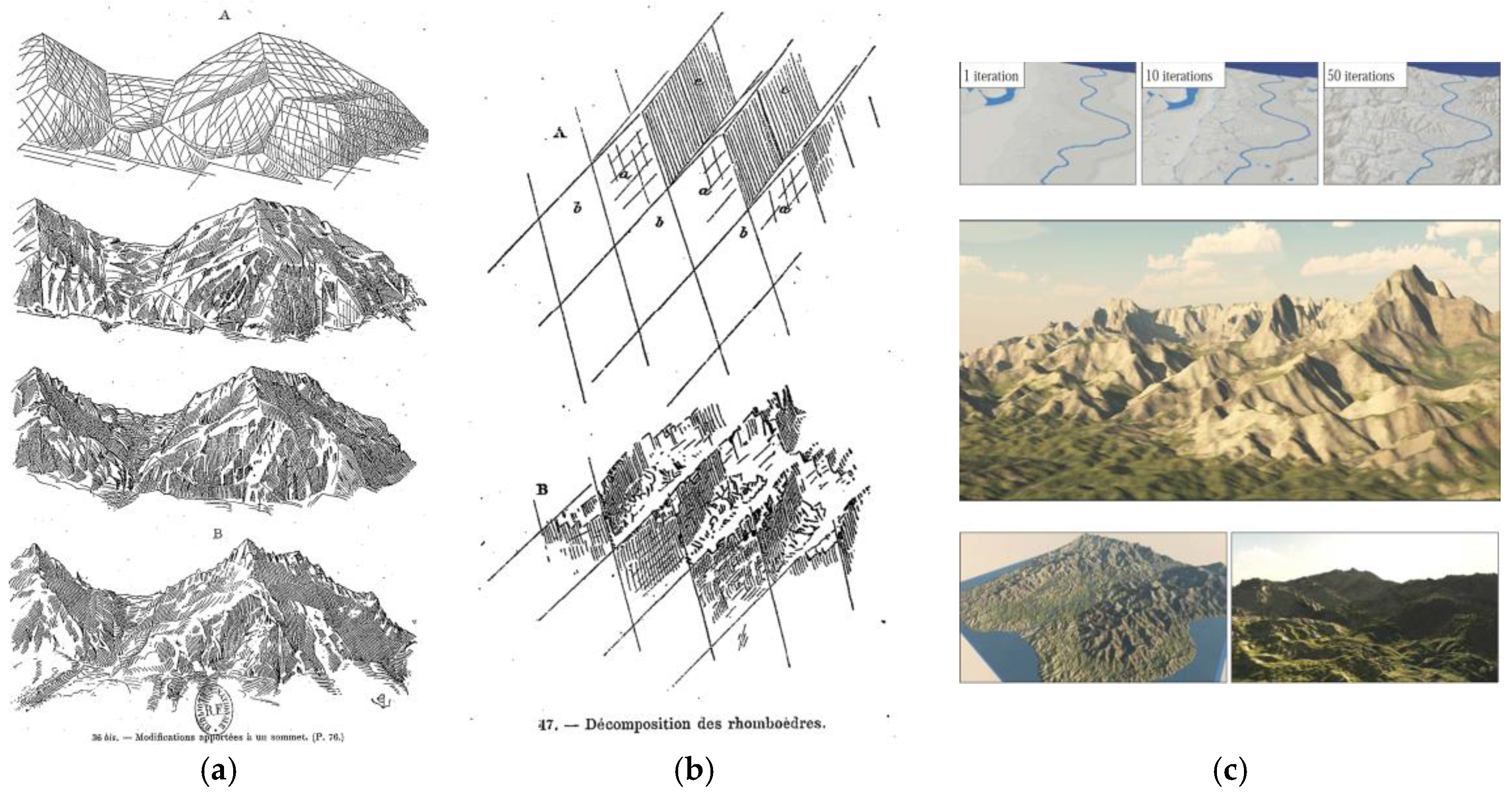
Figure 2.
Some details from historical maps showing the progressive transformation of the cartographic representation of the Alps. (a) Berlinghieri F., 1482, as from [4] (p. 342); (b) Gastaldi G., 1548, as from [4] (p. 342); (c) Magini G.A., 1620, as from [4] (p. 342); (d) Borgonio G.T., 1680, as from [4] (p. 342); (e) Bacler d’Albe., 1798, as from [4] (p. 342); (f) Dufour, 1861, as from [15] (p. 135); (g) Istituto Geografico Militare, 1882, as from [4] (p. 342); (h) Federal Office of Topography, Switzerland, 2000, as from [15] (p. 136); (i) Federal Office of Topography, Switzerland, 2017 [16].


Figure 3.
Example of pictorial distortion of orography and pictorial artefacts to produce a sublime image, evident in this comparison of a painting and a photograph of Monte Viso in the Cotian Alps. (a) Painting of the second half of 19th century by Elijah Walton (1832–1880) [29] (p. 130); (b) Photograph of Monte Viso from approximately the same point of view as the painting. From the comparison some pictorial artefact are evident: the distortion of the alpine orography with a stretch of the vertical dimension, the exaggeration of the rocky features, an exaggerate use of aerial perspective and very bright colors for the upper part of the mountain in order to suggest an even higher elevation of the peak.

Figure 4.
Graphical composition that shows the permanence of the image of alpine Sublime in a 19th century painting (Edward Theodore Compton, Der Cimon della Pala in den Dolomiten, 1896 [29], detail) and in a frame of a 21st century animation movie (Frozen by Walt Dysney Animation Studios, 2013). It is possible to note the similarity in the shape, in the verticality of the faces, the use of clouds to strengthen the sublime emotional effect, the low point of view to strengthen the sense of overwhelming dimension.

Figure 5.
Example of the deformation of terrain and mountain features in the production on a panoramic ski map in the case of the ski resort “Via Lattea” between Italy and France. The graphical elaboration show the relative position of some sites in three images; from the up: the ski map [34], a panorama created with PeakFinder [19], a view from Google Earth. The comparison between the ski map and the other two cartographic views shows the presence of strong local deformations of terrain in the ski map.

Figure 6.
Example of permanence of utopic images of construction in the high mountains: (a) drawing by Bruno Taut, 1919; (b) frame from the animation movie Frozen (Walt Dysney Animation Studios, 2013).
Figure 6.
Example of permanence of utopic images of construction in the high mountains: (a) drawing by Bruno Taut, 1919; (b) frame from the animation movie Frozen (Walt Dysney Animation Studios, 2013).

Figure 7.
Remarkable examples of constructions in the high Alps, that deeply change the image of the landscape: (a) The highest station of the cableway of Aiguille du Midi, France, 1955; (b) The new Monte Rosa Hut, Switzerland, 2009.
Figure 7.
Remarkable examples of constructions in the high Alps, that deeply change the image of the landscape: (a) The highest station of the cableway of Aiguille du Midi, France, 1955; (b) The new Monte Rosa Hut, Switzerland, 2009.
Publisher’s Note: MDPI stays neutral with regard to jurisdictional claims in published maps and institutional affiliations. |
© 2017 by the author. Licensee MDPI, Basel, Switzerland. This article is an open access article distributed under the terms and conditions of the Creative Commons Attribution (CC BY) license (https://creativecommons.org/licenses/by/4.0/).
Share and Cite
MDPI and ACS Style
Piumatti, P. Images for Deconstructing the Complexity and Images for Constructing the Collective Imagination in the Case of the Alpine Landscape. A Selected Overview. Proceedings 2017, 1, 957. https://doi.org/10.3390/proceedings1090957
AMA Style
Piumatti P. Images for Deconstructing the Complexity and Images for Constructing the Collective Imagination in the Case of the Alpine Landscape. A Selected Overview. Proceedings. 2017; 1(9):957. https://doi.org/10.3390/proceedings1090957
Chicago/Turabian StylePiumatti, Paolo. 2017. "Images for Deconstructing the Complexity and Images for Constructing the Collective Imagination in the Case of the Alpine Landscape. A Selected Overview" Proceedings 1, no. 9: 957. https://doi.org/10.3390/proceedings1090957