A Global Analysis of Hunter-Gatherers, Broadcast Fire Use, and Lightning-Fire-Prone Landscapes


1
Institute for a Sustainable Environment, University of Oregon, Eugene, OR 97403, USA
2
Department of Geography and Earth Sciences, University of North Carolina at Charlotte, Charlotte, NC 28223, USA
3
Historical Research Associates, Inc., Portland, OR 97214, USA
*
Author to whom correspondence should be addressed.
Fire 2018, 1(3), 41; https://doi.org/10.3390/fire1030041
Submission received: 3 September 2018
/
Revised: 19 October 2018
/
Accepted: 24 October 2018
/
Published: 25 October 2018
(This article belongs to the Special Issue Land-Use and Fire around the World from the Past to the Present)
Abstract
:We examined the relationships between lightning-fire-prone environments, socioeconomic metrics, and documented use of broadcast fire by small-scale hunter-gatherer societies. Our approach seeks to re-assess human-fire dynamics in biomes that are susceptible to lightning-triggered fires. We quantify global lightning-fire-prone environments using mean monthly lightning and climatological flammability, and then compare how well those environments and socioeconomic variables (population density, mobility, and subsistence type) serve as predictors of observed broadcast fire use from the ethnographic data. We use a logistic model for all vegetated, forested, and unforested biomes. Our global analysis of human-fire-landscape interaction in three hundred and thirty-nine hunter-gatherer groups demonstrates that lightning-fire-prone environments strongly predict for hunter-gatherer fire use. While we do not maintain that lightning-fire-prone environments determine the use of fire by small societies, they certainly appear to invite its use. Our results further suggest that discounting or ignoring human agency contradicts empirical evidence that hunter-gatherers used fire even in locations where lightning could explain the presence of fire. Paleoecological research on fire and hypothesis testing using global fire modeling should consider insights from human ecology in the interpretation of data and results. More broadly, our results suggest that small-scale societies can provide insight into sustainable fire management in lightning-fire-prone landscapes.
1. Introduction
Biogeographers and ecologists have long debated the evolutionary importance of the human use of broadcast landscape fire (broadcast fire use or “BFU”) in the composition, spatial patterning, and distribution of vegetation across the globe [1,2,3,4]. Vegetation in lightning-fire-prone (LFP) landscapes evolved under the influence of fire, long before the arrival of humans [5,6]. However, as fire-wielding ecosystems engineers [7], humans and their ancestors potentially influenced the ecological trajectories of the terrestrial biomes that they have inhabited since at least the Middle Pleistocene (ca. 800,000 years ago) [6]. Indeed, broadcast fire use had striking effects in biomes that did not evolve under frequent fire disturbance [8]. In spite of these and other efforts concerned with empirically disentangling the human from the non-human influences on fire regimes, the nature and scope of the imprint of past settlement and land use on fire regimes and vegetation remains an open question in many regions [4].
In the present day, one of the clearest examples of broad-scale fire regime changes initiated by humans, stems from research pointing to a quantifiable shift in fire seasonality away from the season of optimal fire weather. For example, regional fire seasonality determined from satellites is often out-of-phase with the seasonality of landscape flammability [9], and about 25% of the Earth’s land surface exhibits a bimodal fire seasonality where fire activity occurs during both optimal and suboptimal fire weather conditions [10]. There are also significant unimodal, climate-asynchronous fire regimes that are attributable to human land use and management [11]. Yet these observations are dominated by the burning practices of contemporary agricultural peoples, who are not representative of the smaller-scale societies1 of the past. Global fire modeling studies recognize that important information on historical human-fire dynamics is indeed missing [12,13].
Paleofire and fire modeling studies evaluate longer perspectives but also face challenges for understanding the role of humans in LFP environments due to our inability to distinguish between lightning- and human-caused fires in paleoecological archives [14]. Researchers in paleofire have confronted this problem by searching for “sufficiently conspicuous” evidence that human agency decoupled a fire regime from its climatic drivers [4,14,15,16,17]. However, for studies concerning times and places where small-scale societies were the primary occupants, such evidence is often scarce. Alternatively, the “lightning saturation” hypothesis suggests that lightning density itself is sufficient to explain the presence and patterns of fire even if significant human occupation is evidenced archaeologically [18,19]. The underlying assumptions of these approaches limit a study’s conclusion to one of two extremes—small-scale societies either passively adapted to natural fire regimes or they drastically interrupted them (e.g., McWethy et al., [8]). Mounting evidence suggests that human ignitions can amplify the effect of climate on fire regimes [20,21]. Consequently, we require new approaches capable of accounting for the presence of humans, even where climate and landscape are favorable to frequent fire disturbances (e.g., LFP environments).
Our global-level analysis examines the spatial relationships between LFP environments and BFU by contemporary and historically known hunter-gatherer societies. Based on empirical and theoretical scholarship, we hypothesize that small-scale hunter-gatherer societies living in LFP environments are more likely to use broadcast fire than their counter parts living in non-LFP environments. Fire can be a threat to human lives and natural resources, but, when ignited in the proper time and place, it can provide ecological and economic benefits to humans. Due to our inability to predict lighting ignitions, societies living with lightning-driven fire regimes face considerable uncertainties for subsistence and well-being. Thus, theoretically, small-scale societies in LFP environments have substantial incentives to control fire timing via BFU as a strategy for decreasing subsistence uncertainties [22]. Indeed, empirical studies in human ecology show that BFU provides significant evolutionary advantages to humans living in small-scale societies [23,24]. BFU helps humans to domesticate the landscape by structurally “engineering” vegetation and by scheduling fire’s ecological effects. In addition, many LFP environments are pre-adapted to running surface fires, which makes starting and controlling fires an efficient and rational activity.
To test our hypothesis, we present an original cross-disciplinary research design that combines remotely-sensed lightning, global climate, and historical ethnographic data. We use binary logistic regression methods to model the statistical relationships between the presence of historically observed BFU, associated socioeconomic variables (population density, subsistence type, and settlement mobility), and LFP environments. Our statistical analysis of historical evidence of human-fire-landscape interaction in three hundred and thirty-nine hunter-gatherer groups demonstrates that the most consistent predictor of BFU across Forested and Unforested biomes is an LFP landscape. We find that LFP is the strongest predictor of BFU in Unforested biomes, and after population density, LFP is also a significant predictor of BFU in Forested biomes. We conclude that research related to historical fire regimes at sub-continental scales should attempt to falsify the potential effects of human behavior before declaring the primacy of natural factors, especially in LFP environments.
2. Materials and Methods
2.1. Socioeconomic and Broadcast Fire Use Data
To avoid conflation between the various types of human-environment interactions, we limited our study to small-scale societies that almost exclusively relied on hunting and gathering for their livelihoods. This eliminated groups that use fires to clear vegetation for agriculture and pasture, a nearly ubiquitous practice among traditional agricultural peoples. We created a geodatabase of extant or historically documented small-scale societies using Binford’s [25] global dataset of three hundred and thirty-nine hunter-gatherer groups (See Supplementary S1, Table S1.1 in Supplementary Files). We then conducted a systematic review of ethnographic and historical literature, searching for documentation of fire use for each of the three hundred and thirty-nine groups. We relied heavily, but not exclusively, on four previously compiled syntheses [26,27,28,29]. It should be emphasized that our dependent variable is “documentation” of BFU and not frequency or magnitude of fire use. In other words, we modeled associations related to whether or not hunter-gatherers were observed using fire. This also means that the absence of an observation of BFU for any given group should not be taken as empirical confirmation that a group did not use fire. Nevertheless, we argue that independent of the spatial and ecological scale of its effects, documentation of the presence of the practice itself can be taken as a reasonably reliable proxy for the proclivity of a small-scale society to use fire. In addition, Binford’s three hundred and thirty-nine groups have been systematically investigated by a variety of ethnographers at details sufficient for estimating percentages of diet from hunting, gathering, and fishing. Although fire use was not a main focus of these observations, researchers certainly had the opportunity to note it.
We represented the presence or absence of a documented BFU as a binary variable (1 = positive observation of BFU, 0 = no documented observation) (Supplementary S1, Table S1.1). We limited the criteria for presence of “fire use” to observations of routine and intentional uses of broadcast fire. Broadcast fires are set with a goal of spreading across a landscape, even if burning is not the primary objective. Therefore, examples of “domestic” fire use such as cooking, warming, signaling (by means of smoke), or processing material such as lithics or ceramics, did not qualify as “BFU” since these fires were meant to be spatially confined. Although instances of fire use in warfare might be considered BFU, we did not count these observations since warfare was not generally “routine” among most hunter-gatherers. We discarded vague references that did not adequately describe BFU or that did not specifically name the “band” level sociopolitical groups referenced by Binford. In total, we located references documenting the use of broadcast landscape fire for one hundred and fifty-six of Binford’s three hundred and thirty-nine hunter-gatherer groups (Supplementary S1, Table 1.2).
High flexibility and plasticity of human subsistence strategies means that human-environment interactions vary across geographic and sociocultural domains [30]. Sociocultural variability is high between groups, even where they share the most fundamental mode of production, e.g., hunting and gathering [31]. According to this theory, incentives to use BFU in LFP environments should be modulated by environmental factors related to biome and fuel type, as well as socioeconomic factors related to population density, subsistence type (e.g., relative percentage of diet from gathering plants vs. hunting animals), and settlement mobility patterns. Consequently, in our logistic regression analysis, we stratified our analysis by biome type (see below) and included socioeconomic variables derived from Binford’s original hunter-gatherer dataset (See Supplementary S1, Table S1.1).
2.2. Biomes
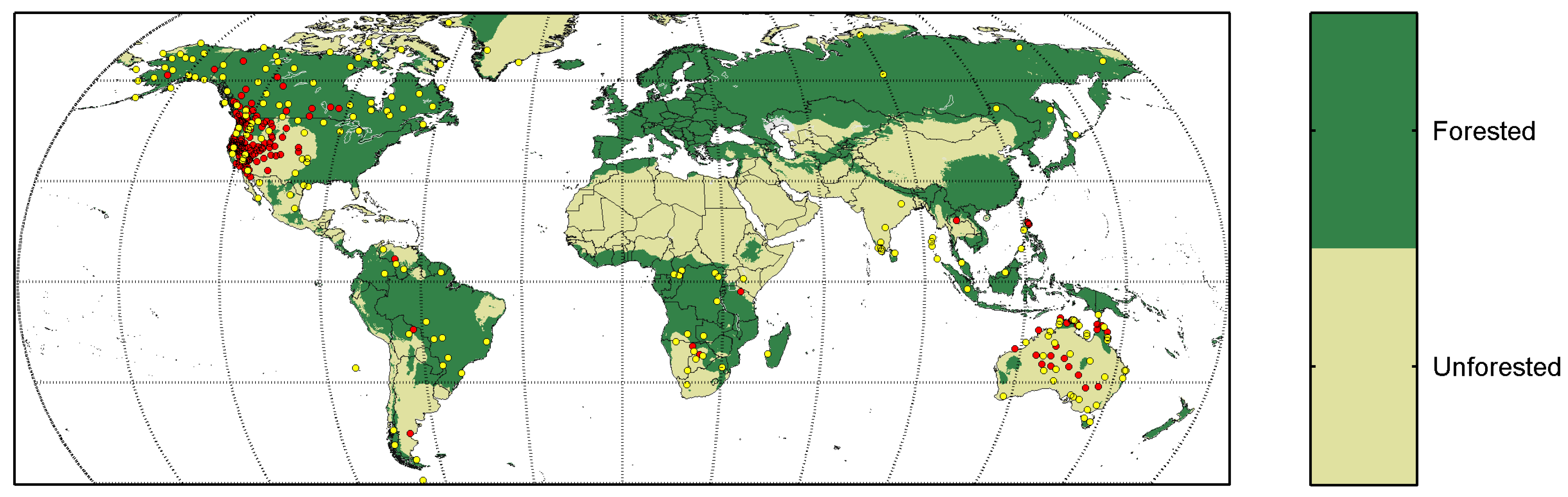
To account for differences in biome and fuel type that affect fire regimes and cultural choices related to fire, we split the analysis into three groups: (1) All data, (2) Forested biomes, (3) Unforested biomes. The biome data, taken from Levavasseur et al. [32], provides two “potential natural vegetation” (PNV) states comprising the first and the second most probable biome. To classify a site as Forested, the grid cell had to have tropical forest, warm temperate forest, temperate forest, or boreal forest, in one or both PNV categories. The Unforested biome was defined as a grid cell when both PNV categories are not one of the forested biome types, and captures cold desert, tundra, grasslands, savanna, desert, and warm desert biomes. The broadly-defined Forested and Unforested superbiomes account for 71% and 29% of the present-day global fire, respectively (e.g., [11,33]). Figure 1 shows the location of Binford’s small-scale societies overlaid on the Forested and Unforested biomes we created, using Levavasseur et al. [32].
2.3. Biophysical Data
Biophysical data sets used in this study were lightning distributions and vapor pressure deficit. All data were analyzed using mean monthly values gridded to 0.5 by 0.5 degree latitude by longitude.
Lightning data was from the Lightning Imaging Sensor (LIS) on the Tropical Rainfall Measuring Mission (TRMM) satellite and the Optical Transient Detector (OTD) on the Microlab-1 satellite [34]. We used the High Resolution Monthly Climatology OTD-LIS combined data product which was distributed at a half degree spatial resolution and derived from the LIS and the OTD data collected between 1995 and 2015 (See Supplementary Files, Supplementary S2, Figure S2.1).
Flammability was determined using the vapor pressure deficit (VPD) calculated using the saturation vapor pressure and relative humidity from Sheffield et al. [35], and mean monthly values were calculated using data from the years 1948 to 2008 (http://hydrology.princeton.edu/data.pgf.php). Similar to fire models, flammability was calculated using a Gompertz (generalized logistic) function of the generic form, as is given below.
where was VPD (), was the flammability index, and and were fitting coefficients (See Supplementary S2, Figure S2.2) that captured behavior similar to past literature (e.g., [36,37,38]), all of which had roots in common flammability indices such as the Chandler Burning Index. The flammability index varied between 0 and 1 and followed an S-shaped curve to mimic the threshold-like behavior of flammability in response to changes in VPD (e.g., [38]).
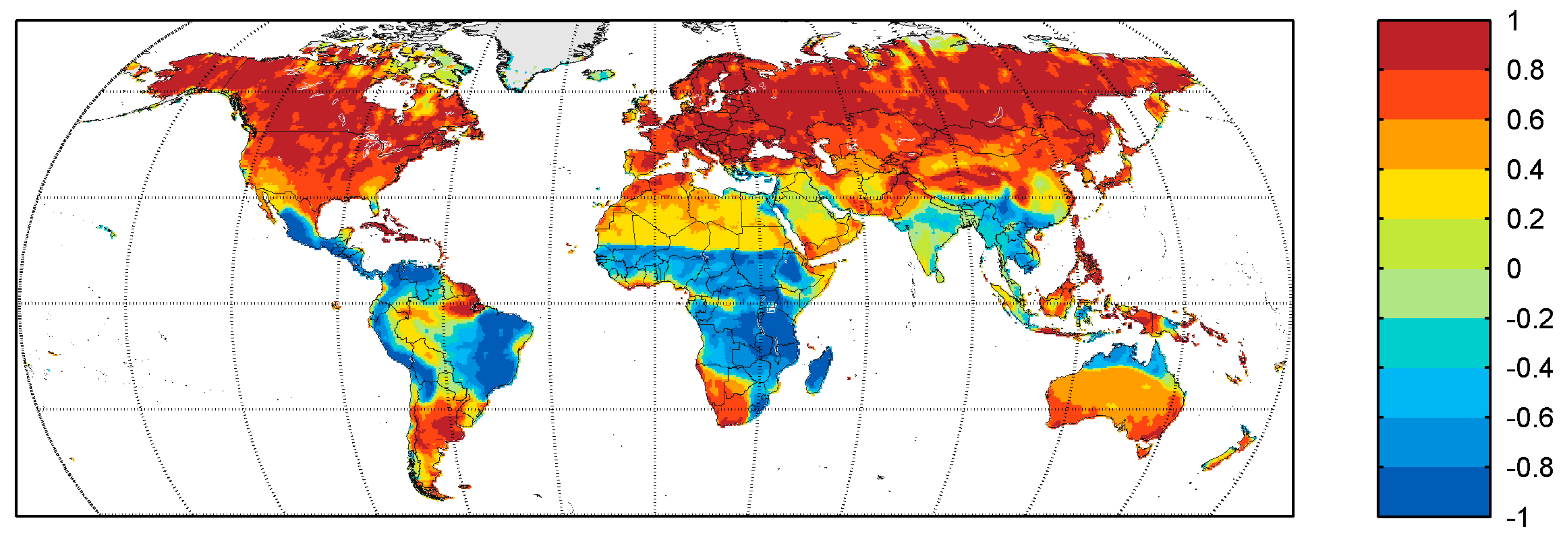
Spatially-explicit temporal correlation of the mean monthly flammability (See Supplementary S2, Figure S2.3) and lightning was calculated to produce a map of correlation coefficients (Figure 2), which showed where the seasonality of lightning and flammability was aligned regardless of whether fires actually occurred. In other words, a location where the season of highest lightning was the season of highest flammability would have high temporal correlation value. The map in Figure 2 provides a way to quantitatively discriminate the global landscape into regions that were and were not lightning-fire prone; this data was referred to as the LFP map, noting that we also discussed the choice of LFP definition in Section 4.1.
2.4. Geodatabase and Logistic Regression
For each culture group’s point location (Figure 1), we extracted the correlation coefficient from the LFP map. We then used binary logistic regressions to model the relationships between BFU, the LFP map (Figure 2), and the socioeconomic variables. The socioeconomic variables and the temporal correlation coefficients from the LFP map were the predictors in the logistic model. We also ran the logistic regression for each of the three biomes (Figure 1) to produce three models. The objective in every regression was to produce a model to effectively predict the binary response vector, which was BFU.
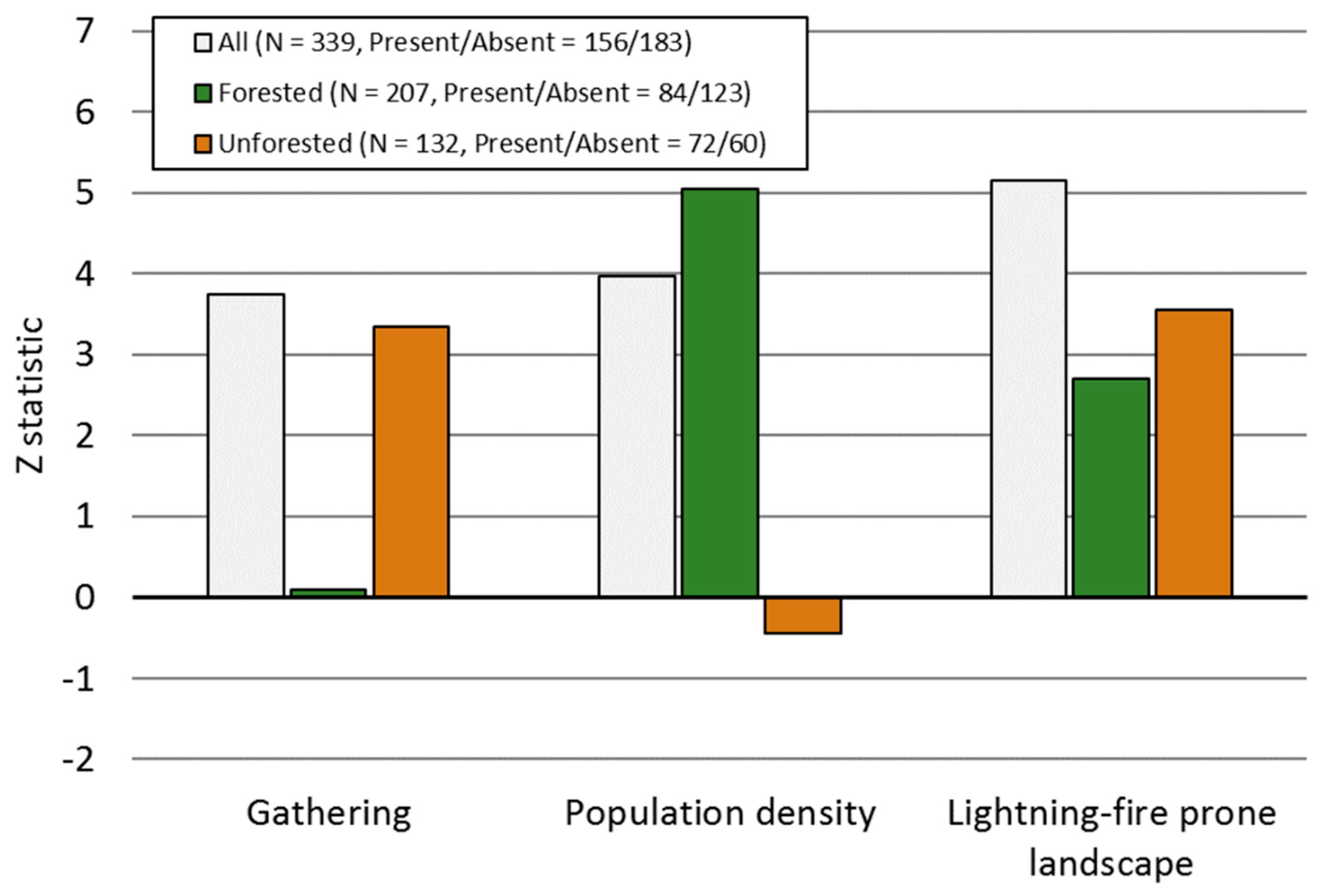
To evaluate the results of the logistic regression and the strength of individual predictors, we used the fit coefficients, standard error in the coefficients, Z statistics, and the p-values. The Z statistic is the ratio of the fit coefficient with the standard error in the fit coefficient, so it is a relatively compact way to assess the strength of any particular predictor variables. An absolute value of Z less than one would indicate that the fit coefficient for that predictor is not significantly different than zero (i.e., little to no predictive power for BFU). Negative Z values indicate an inverse dependence on the predictor. Absolute values of Z greater than two indicate a relatively strong predictor, and generally, the higher the magnitude of Z, the higher the predictive strength. Initial testing showed that several socioeconomic variables (see Supplementary S1, Table S1.3) did not return Z greater than one and were excluded from further testing. The predictors with the highest Z values were Gathering, Population density, and the LFP map.
3. Results
Table 1 shows the results of the regression for the logistic models for All biomes (Global Model), the Unforested biomes, and the Forested biomes. Figure 3 graphically displays the Z statistics for each coefficient. These results show that the LFP map is the strongest predictor of BFU for All biomes and Unforested biomes, but that population density is the strongest predictor of BFU for the Forested biomes. The strength of other predictors varied as a function of biome. Gathering, for example, was a relatively strong predictor for All and the Unforested biomes. LFP was a relatively strong predictor of BFU in Forested biomes.
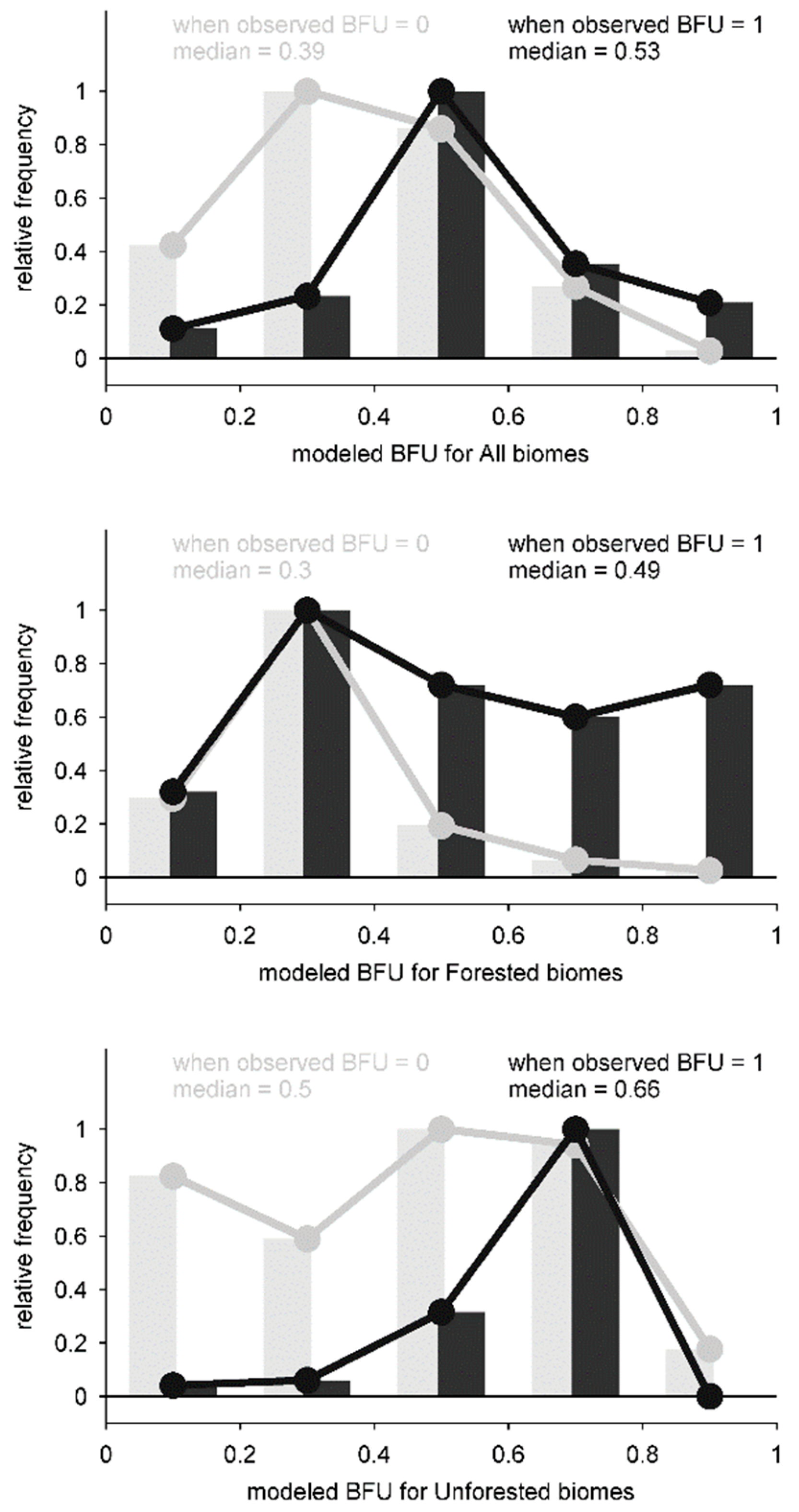
Figure 4 shows the value of BFU predicted by the logistic model for each of the three biomes partitioned into categories when observed BFU is 0 or 1, but we emphasize again that the absence of an observation of BFU cannot be taken as empirical confirmation that a group did not use fire. The converse is, however, also true—there is much greater certainty about BFU = 1 being accurate than BFU = 0. Thus, the focus in our discussion is on the strength of the model in predicting BFU = 1. All three models tended to produce a higher BFU when observed BFU = 1, and a lower BFU when observed BFU = 0, as was evident from the median values of the respective distributions (Figure 4). The distributions were all statistically different (via analysis of variance metrics), but BFU in the Unforested biomes was particularly well-predicted by LFP and Gathering (Figure 3).
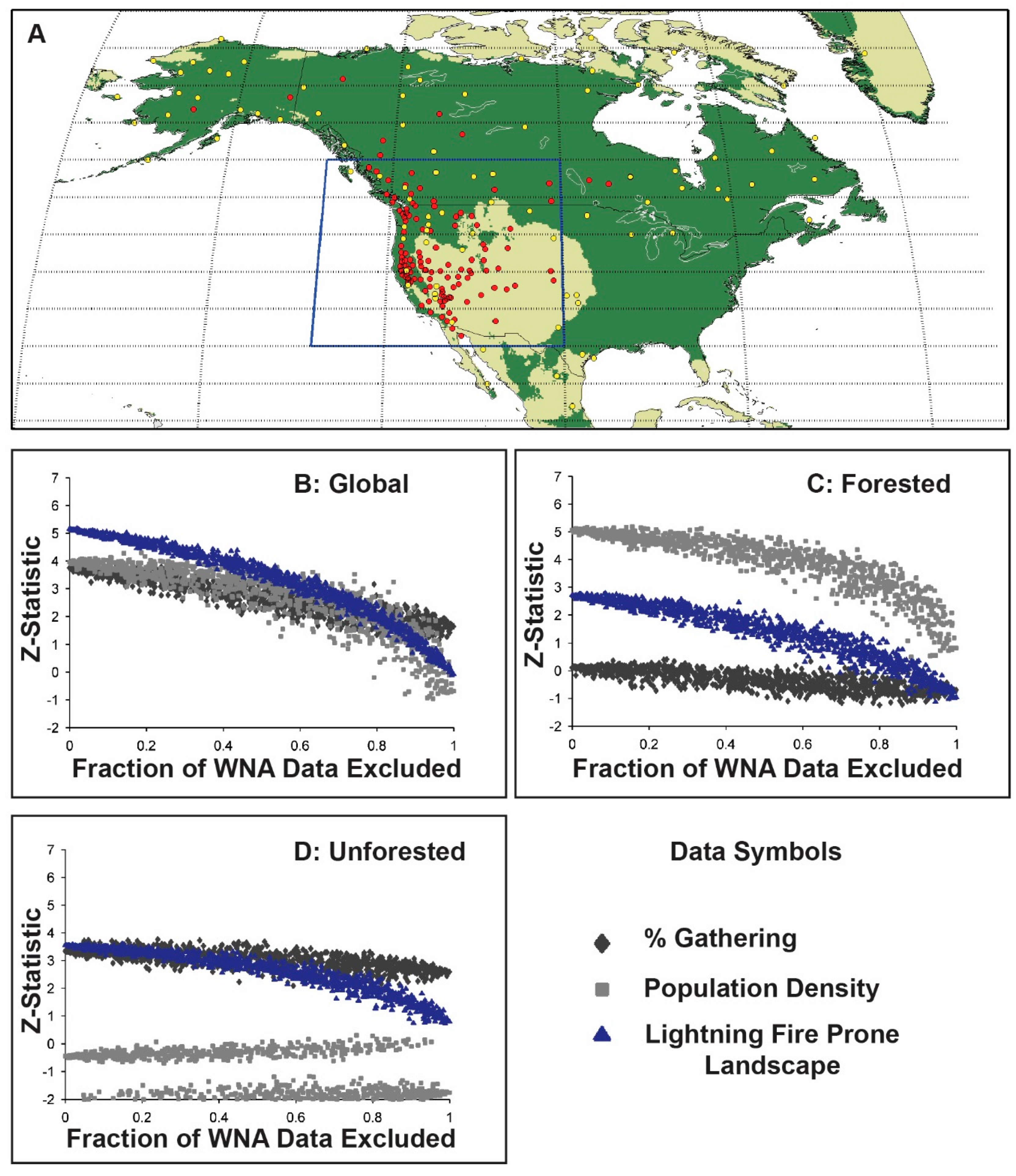
About 42% of the three hundred and thirty-nine sites are in Western North America (WNA [between 30 and 55 N latitude, and 100 and 135 W longitude, Figure 5]), so to evaluate the influence of this sub-region on the overall results, we ran the logistic regression model against subsets of the data that excluded a randomized selection and random number of sites from WNA. Each model was run a thousand times under differing randomization scenarios, and Figure 5 shows the Z statistic plotted as a function of the amount of data from WNA that was included for the different biomes. About 37% of the two hundred and seven sites in the Forested biomes are in WNA, and 48% of the hundred and thirty-two sites in the Unforested biomes are in WNA. When All biomes were considered together (Figure 5a), the LFP map remained the strongest predictor of BFU even when over 60% of the WNA data was excluded. Population density was the strongest predictor of BFU in the Forested biomes (Figure 5b) regardless of how much of WNA was excluded, but the model itself performed relatively poorly (Figure 4). For Unforested biomes (Figure 5c), which have the highest proportion of data in WNA, the logistic regression showed that LFP and Gathering were always the strongest predictors even when large fractions of WNA data was excluded. These results suggest that while the findings relied in part on WNA, they were generalizable to the global scale for both Forested and Unforested biomes.
4. Discussion
4.1. Broadcast Fire Use and Lightning Fire-Prone Environments
Our analysis demonstrates at the global level, that LFP environments are the best predictors for documented BFU. LFP and Gathering are the best predictors of BFU in Unforested biomes, and the model has a relatively robust predictive skill for BFU (Figure 4). The model for Forested biomes has a lower predictive skill for BFU even though population density is the strongest predictor (Figure 3). The ascendance of population density over LFP in Forested biomes may have been caused by sample bias since boreal and tropical forests are over-represented with respect to temperate forests in the modern hunter-gatherer database. As a consequence, much of our forested sample would have long fire return intervals (FRI) even where the seasonality of lightning and flammability were aligned. We compiled results using a definition of LFP that depends on modeled FRI [39] as a scaling factor, but found that the overall conclusions we discussed in this section were unchanged (See Supplementary S2, Figure S2.4). We also suggest that our methodology is better served by explicitly excluding wildfire (i.e., non-BFU fires), modeled or observed, in our logistic regression since current wildfire regimes (including lightning ignition rates) are potentially altered where hunter-gatherer BFU is no longer being practiced or has been modified in response to colonialism or other socioeconomic factors.
While we do not suggest that LFP environments determine whether or not hunter-gatherers used fire, they nevertheless appear to invite its use and active management. This finding is consistent with our hypothesis that humans should be more likely to use fire in LFP environments. Indeed, given sufficient knowledge about fire, its behavior, and its ecological effects, controlling the fire regime is probably one of the most-efficient ways to achieve short-term subsistence goals (e.g., driving game) and to reduce longer term uncertainties associated with the timing, location, and severity of lightning-caused fires, which can severely damage crucial subsistence resources.
Our results also show that the predictive strength of Population density and percentage of subsistence from Gathering varies according to the modeled biome. The significance of these socioeconomic metrics suggests that these semi-quantifiable human dimensions do indeed affect the prevalence of fire use practices in small-scale societies. They also suggest that over the long term, feedback between the sociocultural practices and their ecological effects were positive. For example, globally and in Unforested biomes, the more reliant a society is on gathered foods (i.e., vegetation), the more likely they are to have been observed using a broadcast fire. Similarly, in Forested biomes, higher population densities positively predict for BFU. Given the directionality of these relationships, it is difficult to reason that BFU had negative effects on the society’s resource-base or its demographic trajectory. These results suggest that the use of fire in LFP environments may confer subsistence advantages to societies who wield it, even if those advantages are unintentional [24,40]. One of the principal evolutionary processes driving the transition from hunting and gathering to agriculture is hypothesized to be positive socioecological feedback between demography, economic intensification, and ecosystem engineering activities, such as BFU. Indeed, globally, the vast majority of LFP-Forested biomes have been occupied by agriculturalists for at least the past two millennia.
4.2. Implications for Global Fire Studies
Global fire modeling [13] seeks to model the physical and human factors influencing spatiotemporal patterns of fire around the world, while the majority of paleofire studies (via sedimentary charcoal records, for example) [41] look to understand the influence of large-scale climate and cultural variability on proxy records of fire. These discussions have often concluded that seasonal burned area can be explained by lightning seasonality (e.g., Rabin et al. [13]) and that multiyear to multicentennial burned area can be explained by climate variability [42]) The effects of humans on fire regimes are either considered undetectable in the proxy records (e.g., Power et al. [43]) or are modeled as a population-based scaling factor [13]. However, our analysis quantitatively demonstrates that human presence does not translate to a uniform, scalable effect on the fire regime.
Due to the well-justified concerns about industrial and agriculturally-driven forest conversion, paleoecological research often searches for asynchronous shifts in vegetation-climate dynamics that might indicate historical examples of human-fire driven forest degradation. Maori use of fire in the conversion of New Zealand’s closed-canopy forest to shrub- and grass-land is one of the more dramatic examples of such historically conspicuous vegetation shifts [8]. However, our findings suggest that BFU by non-farming small-scale societies might more commonly be associated with environmental conditions where vegetation is already fire-adapted.
Ethnographic evidence suggests hunter-gatherer fires differ from fires ignited by lightning in important but subtle ways—they are most often of a lower intensity and are smaller in areal extent [44,45]. In comparison to a lightning-dominated fire regime, anthropogenic burning in biomes as diverse as the West African Savanna and the Western Australian Desert produces finer-scaled vegetation patterns that attenuate the severity of the fire regime at a landscape scale [45,46]. Thus, even where extensive BFU does not cause changes in vegetation types, anthropogenic fire can still have significant ecological effects on the landscape mosaic, disturbance processes, and the population dynamics of both flora and fauna.
To best understand the many dimensions of human-climate-fire interactions via a functional relationship in global fire modeling, or as interpreted from paleofire records, a more explicit consideration of human ecology is required. Our results combined ethnographic and biophysical data in a formal statistical model and suggest a possible way forward. While the way forward cannot be perfectly quantified by our results alone, we showed that modeling the occurrence and spread of fire even on LFP landscapes must endeavor to account for the role of human agency. Our findings and suggestions are consistent with a modeling effort that attempt to capture time-varying human-fire interactions [39], and with concerns expressed by studies that consider the intersection of modern-day fire data, global fire modeling strategies, and paleofire data [12,47]. We hope to advance the discussion with methods and results that quantitatively connect physical and cultural fire geographies.
5. Conclusions
In this paper, we investigated the pyrogeography of circumstances under which people use broadcast fire and found that lightning-fire prone (LFP) landscapes in Forested and Unforested biomes were the best predictors of broadcast fire use (BFU). We do not suggest that LFP environments determine whether or not a hunter-gatherer group made use of fire, but rather, the landscape invited the use of fire for active management. This evidence stands in contradiction to any assertion that humans in small-scale societies did not, or could not, actively manage fire in lightning-ignition saturated landscapes.
Our results point to the conclusion that the strongest predictor of hunter-gatherers BFU is an LFP landscape. As many LFP environments are already fire-adapted, human fire use might not always manifest itself as a conspicuous ecological disruption. The fact that the human signal in paleofire archives might not be conspicuous could explain why paleofire research has identified so few instances where small-scale societies have clearly altered fire regimes. Rather than dismissing the importance of humans to fire regimes in LFP environments, we argue that our results point to the need for a closer consideration of historical human-environment interactions, particularly in lightning-fire-prone landscapes. Indeed, conspicuous divergence from expected “natural” patterns, at least at certain spatial resolutions might not be a clear litmus for human-fire-landscape interaction.
As the term Anthropocene becomes increasingly common in environmental science literature, it bears keeping in mind that humans have coexisted and coevolved with fire, in many of Earth’s fire-prone biomes. It is clear that broadcast fire use, at least by small-scale societies, did not always disrupt fundamental aspects of the ecological dynamics of Earth’s biomes. Consequently, rather than viewing the fire practices of small-scale societies as humanity’s “first physical conquest” [48], we might instead discover that they hold some key insights for sustainable fire management of fire-prone environments.
Supplementary Materials
The following are available online at https://www.mdpi.com/2571-6255/1/3/41/s1, Supplementary S1: Socioeconomic and broadcast fire use documentation data; Table S1.1. Binford’s (2002) hunter-gatherer societies, locations, socioeconomic and biophysical variables used in the logistic regression. Table S1.2. Sources for documentation of broadcast fire use among Binford’s hunter gatherers (presence of BFU only). Table S1.3 Explanation of Binford’s socioeconomic variables tested in this paper. Supplementary S2: Biophysical data and Lightning Fire Potential; Figure S2.1. Mean monthly lightning from NASA OTD/LIS, normalized to the maximum value for a given grid cell, during the year. Red values show the month with the most lightning for that location. Ocean data are masked. Figure S2.2. Functional representations of the dependence of flammability on vapor pressure deficit (VPD). The functional form is a Gompertz function constrained to values between 0 and 1. Figure S2.3. Mean monthly flammability calculated as a function of mean monthly vapor pressure deficit (VPD). Red values show the month with the highest climatological flammability, relative to that location, and blue values show the lowest flammability. Figure S2.4. Results of the logistic regression, using LFP (as described in the manuscript), scaled to the modeled Fire Return Interval (FRI) from Pfeiffer et al. (2013) (their Figure 11). The scaling calculation is LFPscaled = LFP*(), where the maximum FRI is 1000 years and, thus, LFPscaled is zero, when FRI is maximum. Figures are otherwise the same as Figure 4 and Figure 5 in the main text.
Data Accessibility Statement
The data used in this analysis are included in the supplementary files.
Author Contributions
Conceptualization, M.R.C., B.I.M. and K.M.D.; Data curation, M.R.C., B.I.M. and K.M.D.; Formal analysis, M.R.C., B.I.M.; Investigation, M.R.C., B.I.M. and K.M.D.; Methodology, M.R.C., B.I.M.; Writing—original draft, M.R.C., B.I.M. and K.M.D.; Writing—review & editing, M.R.C., B.I.M. and K.M.D.
Funding
B.I.M. was supported by NSF BCS-1436496. M.R.C. and K.M.D. received no external funding.
Acknowledgments
Author collaborations benefitted from an NSF Geography and Spatial Sciences BCS-1437074 and Past Global Changes (PAGES) Global Paleofire Working Group supported workshop called “Paleofire: Data-Model Comparisons for the Past Millennium” during Fall 2015 at Harvard Forest, Massachusetts.
Conflicts of Interest
The authors declare no conflict of interest. The funding sponsors had no role in the design of the study; in the collection, analyses, or interpretation of data; in the writing of the manuscript, and in the decision to publish the results.
References
- Sauer, C.O. Grassland Climax, Fire, and Man. J. Range Manag. 1950, 3, 16–21. [Google Scholar] [CrossRef]
- Vale, T.R. The Pre-European Landscape of the United States: Pristine or Humanized? In Fire, Native Peoples, and the Natural Landscape; Vale, T.R., Ed.; Island Press: Washington, DC, USA, 2002; pp. 1–39. [Google Scholar]
- Whitlock, C.; Mcwethy, D.B.; Tepley, A.J.; Veblen, T.T.; Holz, A.; Mcglone, M.S.; Perry, G.L.; Wilmshurst, J.M.; Wood, S.W. Past and present vulnerability of closed-canopy temperate forests to altered fire regimes: A comparison of the Pacific Northwest, New Zealand, and Patagonia. BioScience 2014, 65, 151–163. [Google Scholar] [CrossRef]
- Bowman, D.M.J.S.; Balch, J.; Artaxo, P.; Bond, W.J.; Cochrane, M.A.; D’Antonio, C.M.; DeFries, R.; Johnston, F.H.; Keeley, J.E.; Krawchuk, M.A.; et al. The human dimension of fire regimes on Earth. J. Biogeogr. 2011, 38, 2223–2236. [Google Scholar] [CrossRef] [PubMed] [Green Version]
- Bond, W.J.; Woodward, F.I.; Midgley, G.F. The Global Distribution of Ecosystems in a World without Fire. New Phytol. 2005, 165, 525–537. [Google Scholar] [CrossRef] [PubMed]
- Pausas, J.G.; Keeley, J.E. A burning story: The role of fire in the history of life. BioScience 2009, 59, 593–601. [Google Scholar] [CrossRef] [Green Version]
- Smith, B.D. The ultimate ecosystem engineers. Science 2007, 315, 1797. [Google Scholar] [CrossRef] [PubMed]
- McWethy, D.; Higuera, P.; Whitlock, C.; Veblen, T.; Bowman, D.; Cary, G.; Haberle, S.; Keane, R.E.; Maxwell, B.; McGlone, M. A conceptual framework for predicting temperate ecosystem sensitivity to human impacts on fire regimes. Glob. Ecol. Biogeogr. 2013, 22, 900–912. [Google Scholar] [CrossRef] [Green Version]
- Le Page, Y.; Oom, D.; Silva, J.M.N.; Jönsson, P.; Pereira, J.M.C. Seasonality of vegetation fires as modified by human action: Observing the deviation from eco-climatic fire regimes. Glob. Ecol. Biogeogr. 2010, 19, 575–588. [Google Scholar] [CrossRef]
- Benali, A.; Mota, B.; Carvalhais, N.; Oom, D.; Miller, L.M.; Campagnolo, M.L.; Pereira, J. Bimodal fire regimes unveil a global-scale anthropogenic fingerprint. Glob. Ecol. Biogeogr. 2017, 26, 799–811. [Google Scholar] [CrossRef]
- Rabin, S.S.; Magi, B.I.; Shevliakova, E.; Pacala, S.W. Quantifying regional, time-varying effects of cropland and pasture on vegetation fire. Biogeosciences 2015, 12, 6591–6604. [Google Scholar] [CrossRef]
- Andela, N.; Morton, D.; Giglio, L.; Chen, Y.; Van Der Werf, G.; Kasibhatla, P.; DeFries, R.; Collatz, G.; Hantson, S.; Kloster, S. A human-driven decline in global burned area. Science 2017, 356, 1356–1362. [Google Scholar] [CrossRef] [PubMed] [Green Version]
- Rabin, S.S.; Melton, J.R.; Lasslop, G.; Bachelet, D.; Forrest, M.; Hantson, S.; Li, F.; Mangeon, S.; Yue, C.; Arora, V.K. The Fire Modeling Intercomparison Project (FireMIP), phase 1: Experimental and analytical protocols. Geosci. Model Dev. 2017, 20, 1175–1197. [Google Scholar] [CrossRef]
- Veblen, T.T.; Kitzberger, T.; Villalba, R.; Donnegan, J. Fire History in Northern Patagonia: The Roles of Humans and Climatic Variation. Ecol. Monogr. 1999, 69, 47–67. [Google Scholar] [CrossRef]
- Carcaillet, C. A spatially precise study of Holocene fire history, climate and human impact within the Maurienne valley, North French Alps. J. Ecol. 1998, 86, 384–396. [Google Scholar] [CrossRef] [Green Version]
- Conedera, M.; Tinner, W. The interaction between forest fires and human activity in southern Switzerland. In Biomass Burning and Its Inter-Relationships with the Climate System; Innes, J.L., Beniston, M., Verstraete, M.M., Eds.; Springer: Dordrecht, The Netherlands, 2000; pp. 247–261. [Google Scholar]
- Carcaillet, C.; Bergman, I.; Delorme, S.; Hornberg, G.; Zackrisson, O. Long-term fire frequency not linked to prehistoric occupations in northern Swedish boreal forest. Ecology 2007, 88, 465–477. [Google Scholar] [CrossRef]
- Allen, C.D. Lots of Lightning and Plenty of People: An Ecological History of Fire in the Upland Southwest. In Fire, Native Peoples, and the Natural Landscape; Vale, T.R., Ed.; Island Press: Washington, DC, USA, 2002; pp. 143–194. [Google Scholar]
- Prentice, I.; Kelley, D.; Foster, P.; Friedlingstein, P.; Harrison, S.; Bartlein, P. Modeling fire and the terrestrial carbon balance. Glob. Biogeochem. Cycle 2011, 25. [Google Scholar] [CrossRef] [Green Version]
- Roos, C.I.; Zedeño, M.N.; Hollenback, K.L.; Erlick, M.M. Indigenous impacts on North American Great Plains fire regimes of the past millennium. Proc. Natl. Acad. Sci. USA 2018, 115, 8143–8148. [Google Scholar] [CrossRef] [PubMed]
- Holz, A.; Veblen, T.T. The amplifying effects of humans on fire regimes in temperate rainforests in western Patagonia. Palaeogeogr. Palaeoclimatol. Palaeoecol. 2011, 311, 82–92. [Google Scholar] [CrossRef]
- Lewis, H.T. An Anthropological Critique. In Forgotten Fires: Native Americans and the Transient Wilderness; Lewis, H.T., Anderson, M.K., Eds.; University of Oklahoma Press: Norman, OK, USA, 2002; pp. 17–36. [Google Scholar]
- Smith, E.A.; Wishnie, M. Conservation and Subsistence in Small-Scale Societies. Annu. Rev. Anthropol. 2000, 29, 493–524. [Google Scholar] [CrossRef]
- Bird, R.B.; Bird, D.W.; Codding, B.F.; Parker, C.H.; Jones, J.H. The “Fire Stick Farming” Hypothesis: Australian Aboriginal Foraging Strategies, Biodiversity, and Anthropogenic Fire Mosaics. Proc. Natl. Acad. Sci. USA 2008, 105, 14796–14801. [Google Scholar] [CrossRef] [PubMed]
- Binford, L.R. Constructing Frames of Reference: An Analytical Method for Archaeological Theory Building Using Ethnographic and Environmental Data Sets; University of California Press: Berkeley, CA, USA, 2001. [Google Scholar]
- Stewart, O.C. Forgotten Fires: Native Americans and the Transient Wilderness; University of Oklahoma Press: Norman, OK, USA, 2002. [Google Scholar]
- Williams, G.W. References on the American Indian Use of Fire in Ecosystems; US Forest Service: Washington, DC, USA, 2003.
- Scherjon, F.; Bakels, C.; MacDonald, K.; Roebroeks, W.; Bliege Bird, R.; Bird, D.W.; Bowman, D.M.; Cosgrove, R.; Holdaway, S.; Allen, H. Burning the land: An ethnographic study of off-site fire use by current and historically documented foragers and implications for the interpretation of past fire practices in the landscape. Curr. Anthropol. 2015, 56, 314–315. [Google Scholar] [CrossRef]
- Trauernicht, C.; Brook, B.W.; Murphy, B.P.; Williamson, G.J.; Bowman, D.M. Local and global pyrogeographic evidence that indigenous fire management creates pyrodiversity. Ecol. Evol. 2015, 5, 1908–1918. [Google Scholar] [CrossRef] [PubMed] [Green Version]
- Steward, J.H. The Theory of Culture Change: The Methodology of Multilinear Evolution; University of Illinois Press: Urbana, IL, USA, 1955. [Google Scholar]
- Kelly, R.L. The Lifeways of Hunter-Gatherers: The Foraging Spectrum; Cambridge University Press: Cambridge, UK, 2013. [Google Scholar]
- Levavasseur, G.; Vrac, M.; Roche, D.; Paillard, D. Statistical modelling of a new global potential vegetation distribution. Environ. Res. Lett. 2012, 7, 044019. [Google Scholar] [CrossRef]
- Giglio, L.; Schroeder, W.; Justice, C.O. The collection 6 MODIS active fire detection algorithm and fire products. Remote Sens. Environ. 2016, 178, 31–41. [Google Scholar] [CrossRef] [PubMed]
- Cecil, D.J.; Buechler, D.E.; Blakeslee, R.J. Gridded lightning climatology from TRMM-LIS and OTD: Dataset description. Atmos. Res. 2014, 135, 404–414. [Google Scholar] [CrossRef]
- Sheffield, J.; Goteti, G.; Wood, E.F. Development of a 50-year high-resolution global dataset of meteorological forcings for land surface modeling. J. Clim. 2006, 19, 3088–3111. [Google Scholar] [CrossRef]
- Pechony, O.; Shindell, D. Fire parameterization on a global scale. J. Geophys. Res. Atmos. 2009, 114. [Google Scholar] [CrossRef]
- Li, F.; Zeng, X.; Levis, S. A process-based fire parameterization of intermediate complexity in a Dynamic Global Vegetation Model. Biogeosciences 2012, 9, 2761–2780. [Google Scholar] [CrossRef] [Green Version]
- Rabin, S.S.; Ward, D.S.; Malyshev, S.L.; Magi, B.I.; Shevliakova, E.; Pacala, S.W. A fire model with distinct crop, pasture, and non-agricultural burning: Use of new data and a model-fitting algorithm for FINAL. 1. Geosci. Model Dev. 2018, 11, 815. [Google Scholar] [CrossRef]
- Pfeiffer, M.; Spessa, A.; Kaplan, J.O. A model for global biomass burning in preindustrial time: LPJ-LMfire (v1. 0). Geosci. Model Dev. 2013, 6, 643–685. [Google Scholar] [CrossRef]
- Bird, R.B.; Tayor, N.; Codding, B.F.; Bird, D.W. Niche construction and Dreaming logic: Aboriginal patch mosaic burning and varanid lizards (Varanus gouldii) in Australia. Proc. R. Soc. B 2013. [Google Scholar] [CrossRef]
- Marlon, J.R.; Kelly, R.; Daniau, A.-L.; Vannière, B.; Power, M.J.; Bartlein, P.; Higuera, P.; Blarquez, O.; Brewer, S.; Brücher, T.; et al. Reconstructions of biomass burning from sediment charcoal records to improve data-model comparisons. Biogeosciences 2016, 13, 3225–3244. [Google Scholar] [CrossRef] [Green Version]
- Daniau, A.L.; Bartlein, P.; Harrison, S.; Prentice, I.C.; Brewer, S.; Friedlingstein, P.; Harrison-Prentice, T.; Inoue, J.; Izumi, K.; Marlon, J. Predictability of biomass burning in response to climate changes. Glob. Biogeochem. Cycle 2012, 26. [Google Scholar] [CrossRef] [Green Version]
- Power, M.; Mayle, F.; Bartlein, P.; Marlon, J.; Anderson, R.; Behling, H.; Brown, K.; Carcaillet, C.; Colombaroli, D.; Gavin, D. Climatic control of the biomass-burning decline in the Americas after AD 1500. Holocene 2013, 23, 3–13. [Google Scholar] [CrossRef]
- Lewis, H.T.; Ferguson, T.A. Yards, corridors and mosaics: How to burn a boreal forest. Hum. Ecol. 1988, 16, 57–77. [Google Scholar] [CrossRef]
- Bird, R.B. Disturbance, Complexity, Scale: New Approaches to the Study of Human-Environment Interactions*. Annu. Rev. Anthropol. 2015, 44, 241–257. [Google Scholar] [CrossRef]
- Laris, P. Humanizing savanna biogeography: Linking human practices with ecological patterns in a frequently burned savanna of southern Mali. Ann. Assoc. Am. Geogr. 2011, 101, 1067–1088. [Google Scholar] [CrossRef]
- Hantson, S.; Kloster, S.; Coughlan, M.; Daniau, A.-L.; Vannière, B.; Brücher, T.; Kehrwald, N.; Magi, B.I. Fire in the earth system: Bridging data and modeling research. Bull. Am. Meteorol. Soc. 2016, 97, 1069–1072. [Google Scholar] [CrossRef]
- Marsh, G.P. Man and Nature; or Physical Geography as Modified by Human Action; University of Washington Press: Seattle, WA, USA, 1965; p. 472. [Google Scholar]
| 1 | Small-scale societies are commonly defined as politically autonomous groups of people, with populations ranging in size from 102 to 103 (Smith & Wishnie, 2000 [23]). Subsistence and land use can be characterized as a spectrum of hunting, gathering, and limited agricultural or pastoral activities. |
Figure 1.
Map showing Forested and Unforested superbiomes, with the locations of the documented hunter-gatherer societies used in this study. Sites with BFU are marked by red circles, and those without documented BFU are marked by yellow circles.
Figure 1.
Map showing Forested and Unforested superbiomes, with the locations of the documented hunter-gatherer societies used in this study. Sites with BFU are marked by red circles, and those without documented BFU are marked by yellow circles.

Figure 2.
Map of lightning-fire prone (LFP) environments, calculated as the temporal correlation of mean monthly flammability and lightning. Red means the seasons are in phase, and blue means the seasons are out of phase.
Figure 2.
Map of lightning-fire prone (LFP) environments, calculated as the temporal correlation of mean monthly flammability and lightning. Red means the seasons are in phase, and blue means the seasons are out of phase.

Figure 3.
Z statistics (the logistic regression coefficient for each of the predictors divided by the uncertainty in the coefficient) for each predictor variable, using data from All biomes, Forested biomes, and Unforested biomes.
Figure 3.
Z statistics (the logistic regression coefficient for each of the predictors divided by the uncertainty in the coefficient) for each predictor variable, using data from All biomes, Forested biomes, and Unforested biomes.

Figure 4.
Results of the logistic regression showing the normalized histogram of modeled broadcast fire use (BFU), when observed BFU is zero (light gray, meaning no recorded evidence of fire use), and when observed BFU is one (dark gray, meaning there is recorded evidence of fire use). The graphs represent results using data from (a) All biomes, (b) Forested biomes, and (c) Unforested biomes.

Figure 5.
Evaluating the sensitivity of the logistic regression to randomly exclude different amounts of data, in Western North America (WNA). (A) Map depicts WNA exclusion area and hunter gatherer groups, and results from (B) global (All biomes), (C) Forested biome, and (D) Unforested biome. The x-axis shows how much of the WNA data was included in the logistic regression. Points represent the Z statistic for each predictor, for each biome, for 1000 different randomized WNA data exclusions.


Table 1.
Results from the logistic regression models using Gathering, Density, and LFP as predictors of BFU; where * indicates the predictor is significant at the p < 0.05 level.
Table 1.
Results from the logistic regression models using Gathering, Density, and LFP as predictors of BFU; where * indicates the predictor is significant at the p < 0.05 level.
| Biomes = All (N = 339), BFU Present/Absent = 156/183 | ||||
| Coefficient | Standard Error | Z | p | |
| Constant | −1.9614 | 0.3323 | −5.9041 | 3.55 × 10⁻⁹ |
| Gathering* | 0.0207 | 0.0055 | 3.7512 | 1.76 × 10⁻⁴ |
| Density* | 0.0171 | 0.0044 | 3.9653 | 7.33 × 10⁻⁵ |
| LFP* | 0.0149 | 0.0029 | 5.1489 | 2.62 × 10⁻⁷ |
| Biomes = Forested (N = 207), BFU Present/Absent = 84/123 | ||||
| Coefficient | Standard Error | Z | p | |
| Constant | −1.6934 | 0.3868 | −4.3784 | 1.20 × 10⁻⁵ |
| Gathering | 0.0008 | 0.0079 | 0.1011 | 0.92 |
| Density* | 0.0301 | 0.0060 | 5.0556 | 4.29 × 10⁻⁷ |
| LFP* | 0.0094 | 0.0035 | 2.7088 | 6.75 × 10⁻³ |
| Biomes = Unforested (N = 132), BFU Present/Absent = 72/60 | ||||
| Coefficient | Standard Error | Z | p | |
| Constant | −2.5255 | 0.7463 | −3.3839 | 7.15 × 10⁻⁴ |
| Gathering* | 0.0371 | 0.0111 | 3.3396 | 8.39 × 10⁻⁴ |
| Density | −0.0032 | 0.0072 | −0.4407 | 0.66 |
| LFP* | 0.0226 | 0.0064 | 3.5498 | 3.86 × 10⁻⁴ |
© 2018 by the authors. Licensee MDPI, Basel, Switzerland. This article is an open access article distributed under the terms and conditions of the Creative Commons Attribution (CC BY) license (http://creativecommons.org/licenses/by/4.0/).
Share and Cite
MDPI and ACS Style
Coughlan, M.R.; Magi, B.I.; Derr, K.M. A Global Analysis of Hunter-Gatherers, Broadcast Fire Use, and Lightning-Fire-Prone Landscapes. Fire 2018, 1, 41. https://doi.org/10.3390/fire1030041
AMA Style
Coughlan MR, Magi BI, Derr KM. A Global Analysis of Hunter-Gatherers, Broadcast Fire Use, and Lightning-Fire-Prone Landscapes. Fire. 2018; 1(3):41. https://doi.org/10.3390/fire1030041
Chicago/Turabian StyleCoughlan, Michael R., Brian I. Magi, and Kelly M. Derr. 2018. "A Global Analysis of Hunter-Gatherers, Broadcast Fire Use, and Lightning-Fire-Prone Landscapes" Fire 1, no. 3: 41. https://doi.org/10.3390/fire1030041