Searching for the History of the Ancient Basilicata: Archaeogeophysics Applied to the Roman Site of Forentum


1
Tomogea srl, C.da Fontanelle, 85052 Marsico Nuovo (PZ), Italy
2
Hydrogeosite Laboratory, CNR-IMAA, C.da Fontanelle, 85052 Marsico Nuovo (PZ), Italy
3
Soprintendenza Archeologia Belle Arti e Paesaggio della Basilicata, Via dell’Elettronica 7, 85100 Potenza, Italy
4
Nostoi srl, Via Dante, 134, 85024 Lavello (PZ), Italy
*
Author to whom correspondence should be addressed.
Heritage 2019, 2(2), 1097-1116; https://doi.org/10.3390/heritage2020072
Submission received: 21 February 2019
/
Revised: 26 March 2019
/
Accepted: 4 April 2019
/
Published: 9 April 2019
(This article belongs to the Special Issue Geophysical Surveys for Archaeology and Cultural Heritage Preservation)
Abstract
:This paper describes the results obtained using an archaeogeophysical-based approach for discovering new Roman structures belonging to the ancient settlement of Forentum, currently identifiable by a well-preserved sanctuary from the third century BC. The investigated area has been affected by invasive anthropic activities that have partially damaged the Roman structures. Extensive geophysical measurements, including detailed ground-penetrating radar investigations supported by magnetometric data, have allowed for the identification of an impressive complex of structures composed of various buildings. Magnetometric and electromagnetic anomalies suggest the existence of an “urban” dimension close to the Gravetta Sanctuary, totally unearthed and unknown until now, organized into regular patterns in a similar way to the most famous site in the vicinity of Bantia, or the famous Apulian archaeological sites of Ordona and Arpi.
1. Geophysical Techniques for Archaeological Issues
Geophysical investigations are a valuable resource for studying the subsoil in order to detect archaeological remains and reconstruct buried settlements. An increasing interest in the geophysical techniques applied to the field of archaeology has contributed to the creation of a new discipline in the field of the geophysics, known as archaeogeophysics. Archaeogeophysics, an integral part of the more extensive discipline of geo-archeology, provides an alternative approach for geophysicists based mainly on the use of high-resolution methods with centimeter accuracy and on the constant support of the archaeologists [1,2]. Data-georeferencing is an unavoidable stage in the research stage, and the comparison of data with evidence obtained through direct observations represents the key to interpreting geophysical data. A strong collaborative partnership with archaeologists is obviously required in order to identify relationships within the investigated area, and to correctly interpret the distribution of archaeological remains. Moreover, there are obvious limits related to geophysical acquisitions as a result of the uncertainties in the interpretation of the results. Indeed, the lack of direct information regarding the investigated site, as well as the noise created by obstacles (walls, monuments, historic buildings, underground utilities, etc.), can interfere with the quality of the data, as in the case of urban applications [3,4].
Among the various geophysical techniques, the most useful for archaeological analyses are the magnetometric and electromagnetic methods. Both techniques are totally non-invasive, repeatable, and able to provide high-resolution images at sufficient depths. Their effectiveness is strongly site-dependent, but it is generally not less than two to three meters, which is appropriate for the most common applications on Italian archaeological sites [5,6].
Ground penetrating radar (GPR) is the highest resolution geophysical method for archaeological applications, and is concerned with the study of electromagnetic (e-m) reflections caused by variations of the three physical parameters that regulate the e-m behavior of the investigated medium. These parameters are electrical conductivity, dielectric permittivity, and magnetic permeability; they are the main factors of the attenuation phenomena and the velocity of propagation of e-m waves [7,8,9,10].
The key feature of GPR investigation is the central operating frequency of the antenna. The lower the frequency, the lower the obtainable resolution, but the greater the investigable depth. The higher the frequency, the greater the resolution, but the depth reached by the signal is decreased. Depending on the expected sizes and depths of the archaeological features, there is often a compromise when choosing the appropriate antenna frequency [11,12]. As a consequence, it is necessary for a continuous and effective collaboration to be sought between archaeologists and geophysicists in order to improve the quality of the collected data and to minimize misunderstandings related to the interpretation of results [13]. Nowadays, innovations in GPR applications include the use of systems constructed from arrays of antennas. These systems provide a reduction in the time of the data acquisition, and enhance the quality of the information, and they are particularly interesting for extensive applications of GPR, especially when it is necessary to investigate large areas.
GPR allows for the discovery of archaeological features in lacustrine areas; the main problem is related to attenuation, caused by the presence of clay or a high water content, which can significantly reduce the ability of the system to investigate the subsoil at greater depths [14,15].
Magnetometric data provide measurements of the variation in the Earth’s magnetic field, regardless of the presence of anomalous bodies placed in or on the surface of the subsoil. This method monitors certain physical properties, as in the case of magnetic susceptibility, relating to the magnetic behavior of the constituent materials of the archaeological targets. These magnetic properties are strongly influenced by the transformational processes experienced by the archaeological structures or objects, which are caused by heating processes realized at temperatures exceeding the Curie temperature. For this reason, for many man-made objects of archaeological investigation interest, it is possible to identify an induced magnetization relative to the Earth’s field that is directly proportional to the magnetic susceptibility, plus a thermoremanent magnetization as a result of anthropic work. The appropriate units used to measure the field strength are nanoTesla (nT) and picoTesla (pT). All soils are characterized by a magnetic sensitivity that varies according to the characteristics of the materials and any working it has undergone. In order to discriminate archaeological features, it is necessary for a distinct contrast to exist between a structure and the surrounding soil [16]. In order to simplify the detection of anomalous events in the subsoil that are attributable to archaeological remains, it is essential that the appropriate instrumentation and configuration are selected. The most used field instruments for measuring the magnetic variations attributable to archaeological objects are the proton magnetometer, the Overhauser magnetometer, or the optically pumped alkali-vapor magnetometer.
In archaeological contexts, cesium or potassium vapor magnetometers are preferable to other technology for the results they obtain, characterized by the high signal-to-noise ratio and the high sensitivity of 0.1 picotesla (10−12T). Furthermore, for archaeological applications, it is necessary for the adoption of gradiometric configurations (MAG), where two or more sensors provide measurements of the intensity of the Earth’s magnetic field at different heights. The MAG allows for the recording of a signal that is independent of the fluctuations caused by daytime variations in the Earth’s magnetic field, enhancing the contrast between anomalous bodies with potential archaeological interest and the subsoil in which the objects are located. This acquisition mode provides two distinct functions of signal in the space–time domain, enabling the enhancement of results caused by the presence of anomalous bodies in the subsoil that have potentially been created by archaeological remains [17,18].
The integration of different geophysical techniques is key for the success of geophysical techniques applied in archaeological fields [19]. There is a large number of documented examples of the integration of MAG and GPR, where MAG is used to give a large-scale reconstruction of the anomalies related to archaeological features, while GPR is often applied to obtain details of the most interesting anomalies. In this way, geophysicists and archaeologists try to combine the advantages of the MAG methods, its speed and low cost, with those of the GPR, which allows for higher resolutions at known depths [20,21,22,23]. In the past, the Lucania territory has been widely studied, with integrated geophysical activities aimed at discovering the outstanding and significant history of the region now known as Basilicata. Indeed, thanks to its particular position, in the heart of southern Italy, it was at the crossroads of important civilizations. It is possible to find structures belonging to Greek, Roman, Samnite, and Lucania settlements. The presence of masonry walls of notable size, typical of local architecture of antiquity, generate physical anomalies that are easily detectable with geophysical techniques [24,25,26,27,28,29,30,31].
The main aims of geophysical investigations, supported by GPS information and integrated with archaeological data, are as follows:
- -
- the identification of the presence of archaeological remains in rural areas where illegal excavations have taken place;
- -
- the positioning of buried structures in rural areas characterized by different types of soil disturbance; and
- -
- the analysis of the distribution of potential anomalies with respect to existing archaeological structures.
2. Archaeological Context
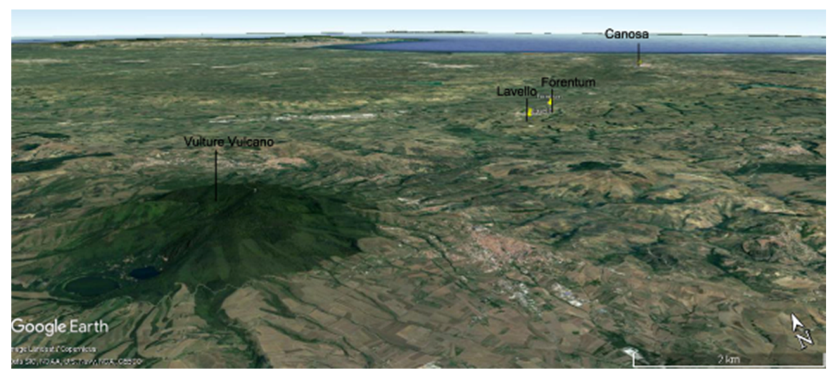
During the last forty years, archaeologists have disagreed about the identification of the site, referred to in ancient literary sources as Forentum, and possibly situated in the current towns of Forenza or Lavello. Archaeological discoveries during the past thirty years seem to confirm that Lavello is the Samnitic settlement cited by Livius (9.20.9) and Diodorus Syculus (19, 65, 7) as the site conquered by the Romans in 318 or 315 BC. In particular, the hill of Gravetta is one of the most interesting and important places for understanding the transition from the Daunii civilization (which inhabited northern Apulia before the arrival of the Romans) to the Roman domination of the territory, with the delicate intermediate Samnitic phase between the fourth and third century BC. The Romanization of this territory occurred during the period of the Second Samnitic War, and involved Canusium, a faithful ally of Rome, as well as the founding of the Roman colony of Venusia in 290 BC.
The hill of Gravetta faces southwest on the “valle delle Carrozze”, which is a natural route that links the two important historical locations of Lavello and Canosa (see Figure 1 and Figure 2).
In the past, Gravetta was referred to as the “acropolis” of the site, but more recent studies have demonstrated that the settlement of the classical period was made up of several separate centers within the same area.
At the beginning of the fourth century BC, near to Gravetta, a number of small, quadrangular, temporary buildings were created. Their typical structure comprised of a rectangular fence containing six holes filled with votive ceramic offerings; at the end of the fourth century BC, these structures hosted a room called oikos-sacellum (a structure composed of richly decorated masonry walls) and an auspicious enclosure with seven votive wells, called an auguraculum. These structures have been interpreted as being a sacred fence and a permanent augural temple.
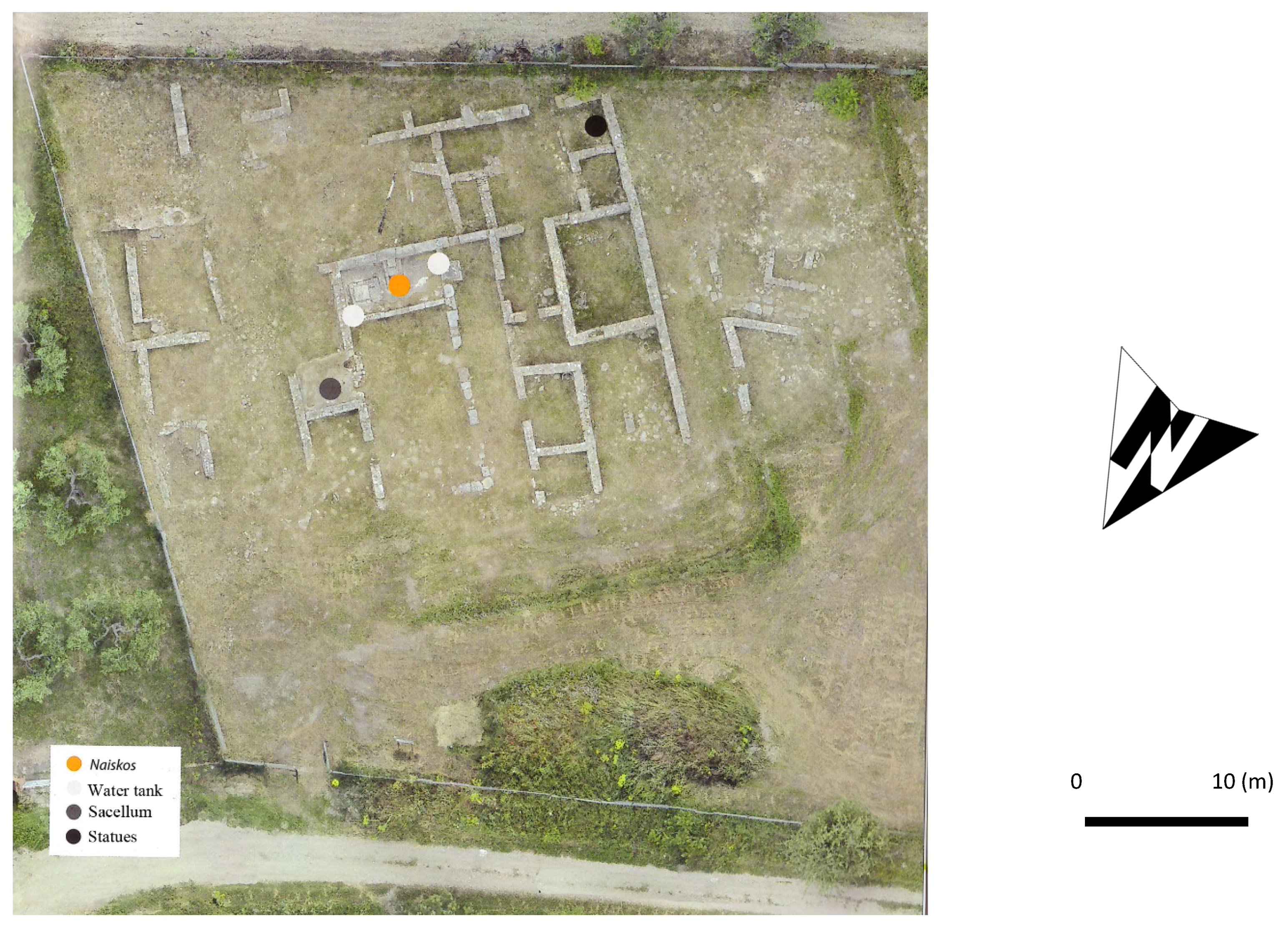
The influence of Rome, or, more precisely, that of its allies, determined the end of its development. On the Gravetta hill, at the beginning of the third century BC, a monumental sanctuary with a columned front hosting a naiskos (a small temple in tufa), two tanks, and a water abstraction well, were constructed (see Figure 3). These structures indicate the Roman presence on the site Additionally, in the third century BC, some impressive chamber tombs were realized along the “Carrozze valley”, which links the site of Forentum with the important historic site of Canosa.
The naiskos is oriented NE–SW; on the southeastern blocks, there are traces of three Doric columns; in the northwestern row of orthostats, there was a door. Plaster covered all four walls of the naiskos. One of the impressive features of the religious complex is the two perfectly plastered bell-shaped tanks, with an overall capacity of over 37,000 liters.
Inside the sacellum, there are a tufa molded plinth and a parallel-piped block that are probably the bases of a statue and the altar. The floor of the sacellum is tiled with white monochromatic mosaic and medium-sized tesserae. The structure hosts a mosaic room with a deep drain-well, perhaps belonging to the original phase; for this reason, it is possible that the complex was focused on water worship, as also confirmed by the presence of the Latin votive statues. Finally, the styli found in the sanctuary indicate the importance of writing for ritual ceremonies, conceivably introduced at Forentum by the Romans.
In the second century BC, the structures were destroyed, together with the remains of a bloody sacrifice (piaculum), represented by a goat’s horn and two deer’s antlers on the floor of the sacellum, probably due to the abandonment of the worship.
In the sanctuary, there is a dedicatory inscription to Heracles and another that mentions temples dedicated to Minerva and the Lares, dating back to the first century BC.
In addition, the naiskos opens on three sides, with a monumental front formed by a Doric colonnade facing the mountain.
In this archaeological framework, geophysical investigations are fundamental for exploring this particular location and for understanding the original extent of the sacred complex.
The results of the recent geophysical research in the western area, where a remarkable pair of clay busts were found in the past, have been very interesting in revealing the existence of several structures. These two findings are probably ritual offerings to the deities venerated here, and perhaps reproduce cult statues. Despite their uncertain provenance, it is conceivable that the Romans did not remove an erstwhile divine couple, as often happened in the Osco-Samnitic and Lucanian sanctuaries of this area, and transform them into Greek gods. Macedonian influence, shaped by the Daunian culture, is also evident in the Gravetta sanctuary. Considering that the Romans worshipped San Leucio in Canusia, and Belvedere in Luceria, a small head depicting a goddess found in the sanctuary of Gravetta suggests they also revered Athena Ilias. A more detailed description of the site is available in the literature [32,33,34,35].
3. Material and Methods
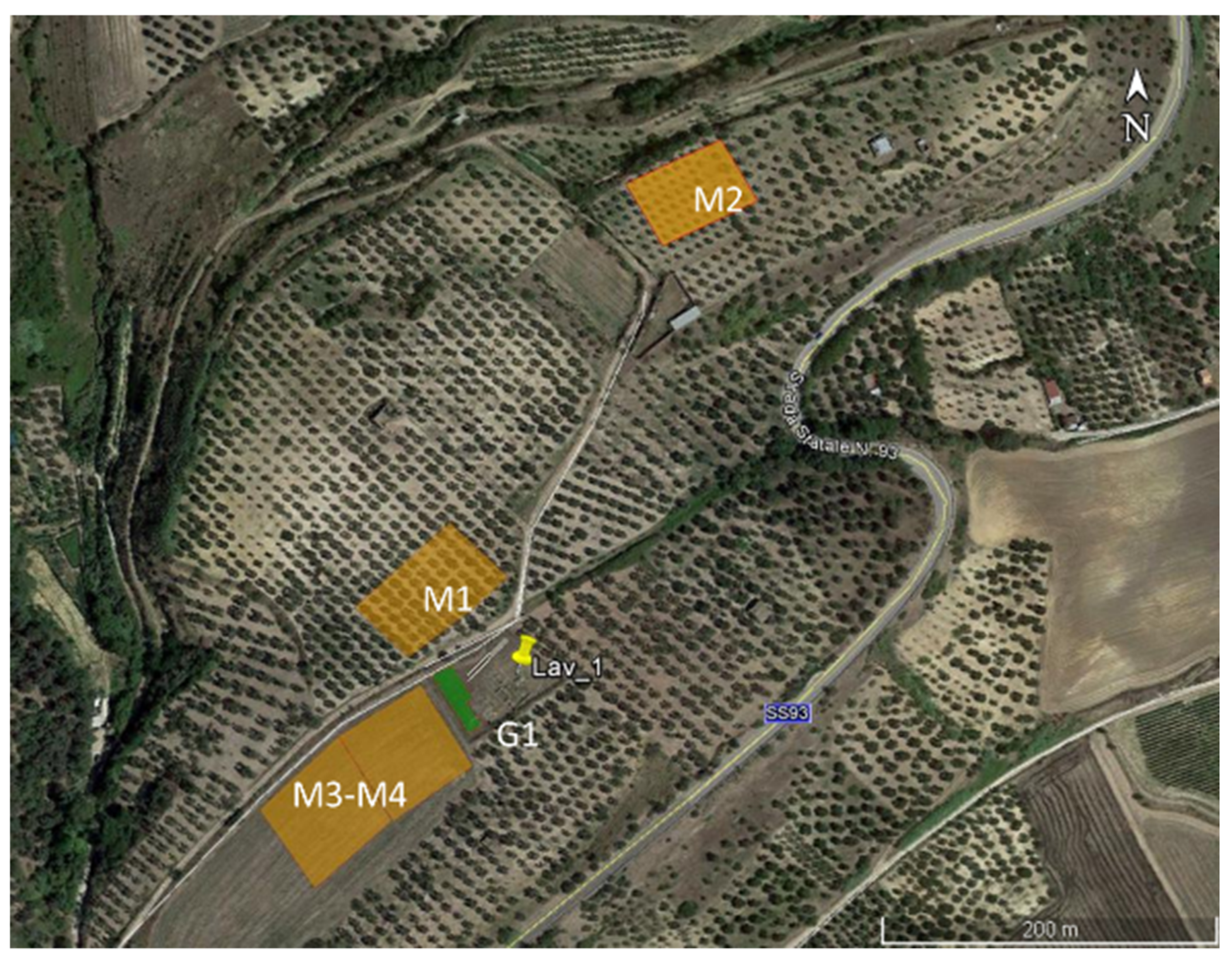
The case analyzed relates to the various areas surrounding the archaeological site of Forentum (Lavello, Italy). The site is located on a hilly area, with gentle slopes dedicated to agricultural activities. As indicated in Figure 4, on the back of the archaeological research conducted in the past by archaeologists and public authorities, five different areas were investigated.
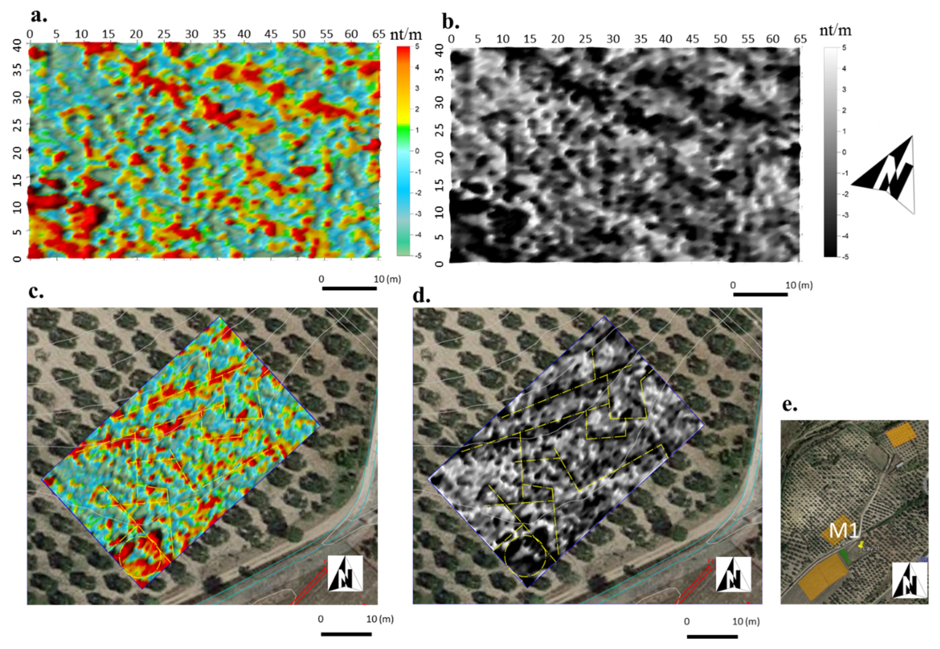
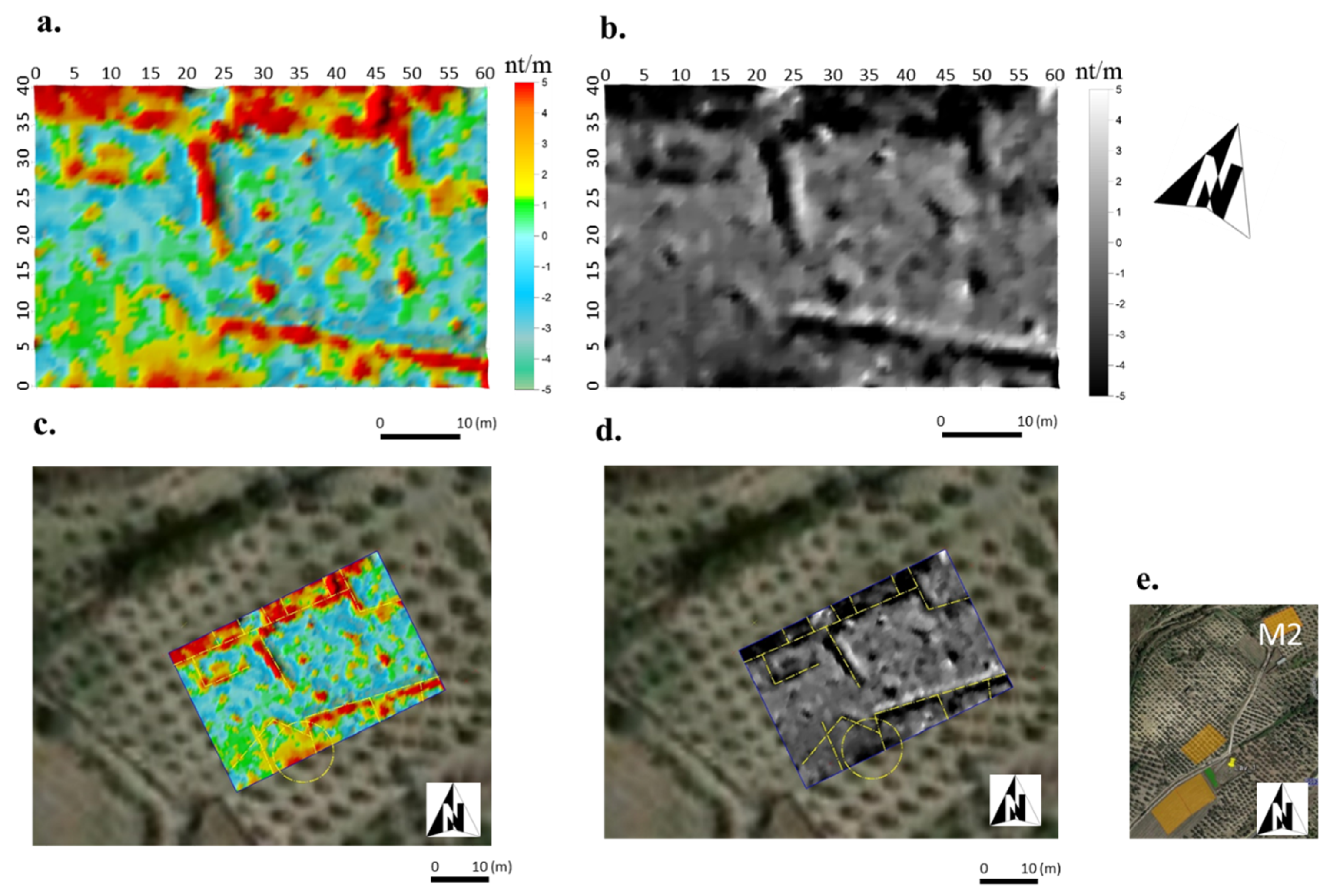
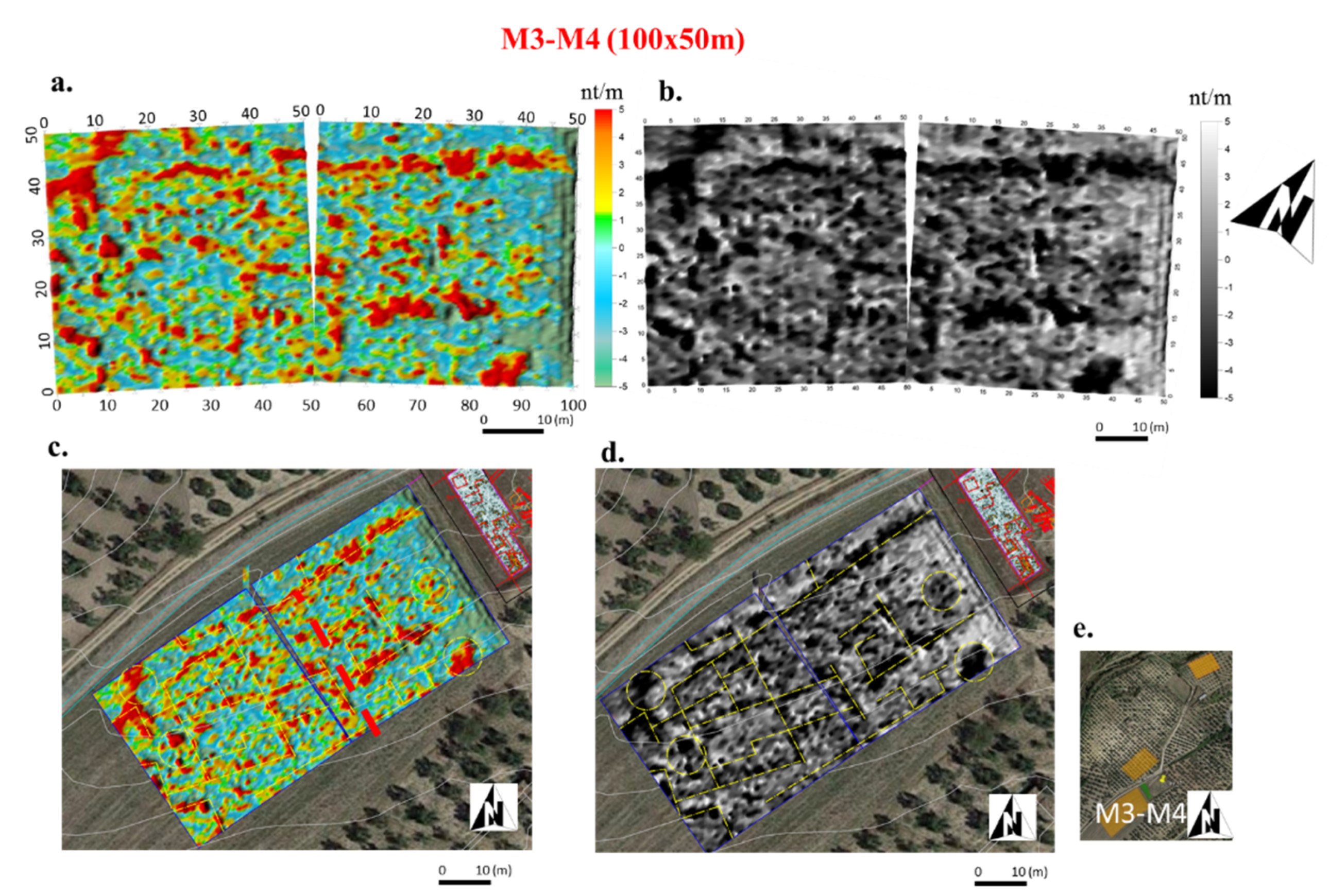
The first, known as M1, M2, M3, and M4, were investigated using MAG, while the last, named G1, only used GPR. The archaeologically excavated site is located near G1 and covers a very limited area of the anticipated full extent of the archaeological site. The presence of steel fences around the archaeological site prevented the use of MAG immediately adjacent to the excavated structures. M1 is a rectangle with dimensions 65 m × 40 m, and is located in an olive grove. The soil has been drastically altered by agricultural activities and looting operations common in this area. M2 is also a rectangle, sized 60 m × 40 m, and is located at the northeast of the archaeological site and is the farthest away of the investigated areas. The area is characterized by the presence of olive groves and ancient terracing walls, presumably of the same period as the Roman site. M3 and M4 are located on the west side of the archaeological site and provide more suitable conditions for geophysical readings, thanks to the total absence of invasive agricultural activities or looting. Both of these investigated areas were flat rectangles of 100 m × 50 m.
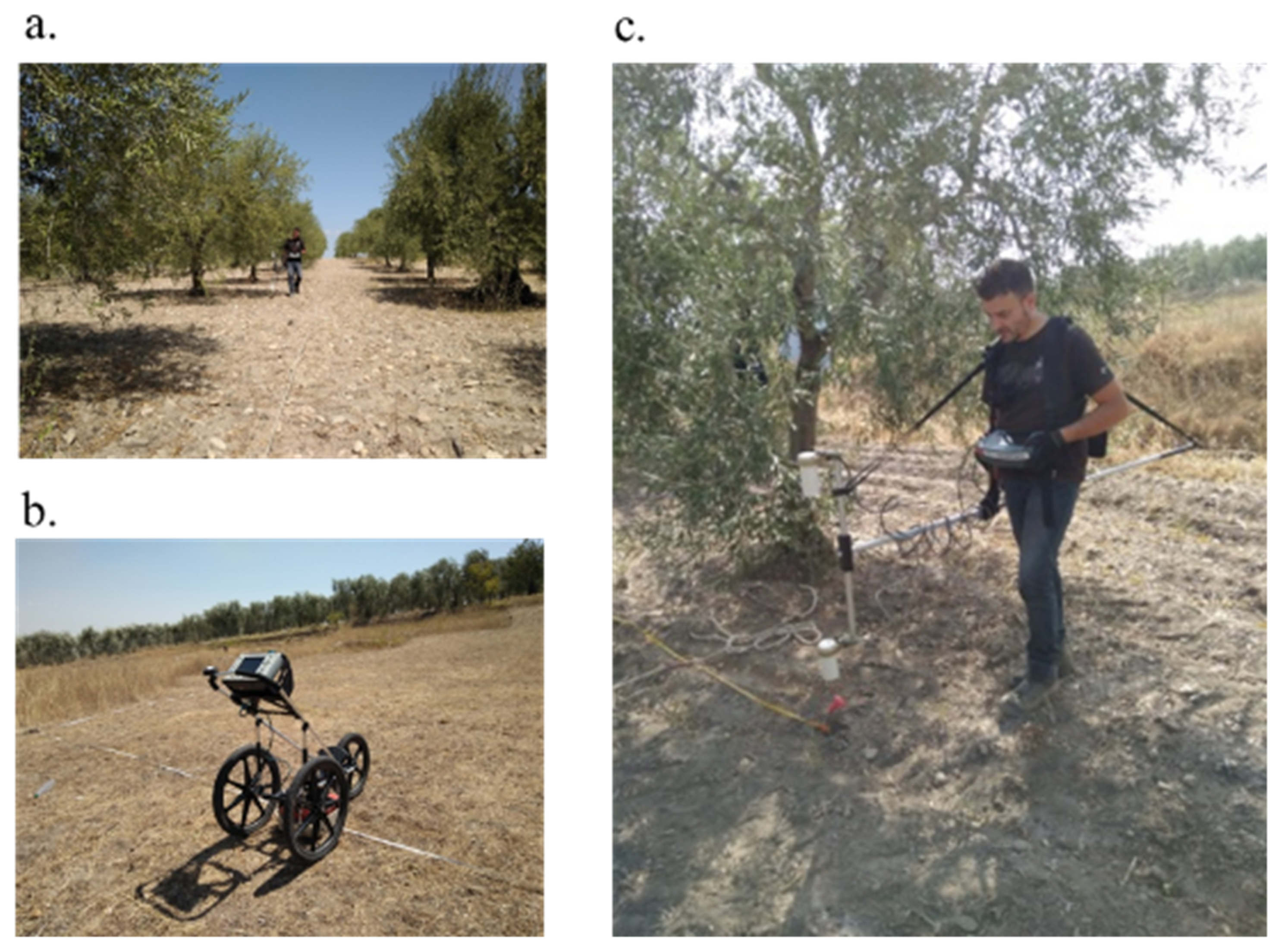
The MAG investigations were achieved with the optical pumping magnetometer G-858 (by Geometrics) in a gradiometric configuration, with two magnetic probes set vertically at a distance of about 1 m from each other (see Figure 5a,c). CSAZ software (by Geometrics) was used to correctly direct the sensor axes so as to take complete account of the Earth’s field, inclination, and declination at the site being investigated. The data were acquired along parallel paths 1 m apart, with a sampling rate of 10 Hz, using a snake configuration to achieve a mean spatial resolution of 1.0 m × 0.125 m.
The MAG data, before being georeferenced, were processed in order to increase the signal-to-noise ratio. The processing steps adopted in this case include (i) a de-stagger filter, to compensate for data collection errors caused if the operator starting starts the recording for each line, with an time- delay; (ii) a de-stripe operation, to equalize the underlying differences between grids and to reduce the linear features; (iii) a de-spike filter for removing spikes or isolated extreme values, and replacing them with a more realistic value; and (iv) the application of gridding operations, based on the Kriging algorithm, to identify magnetic anomalies relating to archaeological features.
GPR investigations were performed using the Sir-3000 GPR System (see Figure 5b) coupled to a bistatic antenna with an operating frequency center of 400 MHz. Readings were made according to the reflection mode, using a transmitter and receiver placed on the same line of acquisition. The data were acquired in a continuous operation supported by an appropriately calibrated survey-wheel, with a time window of 80 ns, a samples per scan setting of 512, at a resolution of 16 bits, and a transmit rate of 100 kHz. The GPR data were recorded using a grid that uses perpendicular lines separated by only 50 cm, which aimed to obtain a high resolution over an area of about 320 m2. To cover the entire area, a total distance of 2.5 km was scanned, and the recordings were used to create a 3D image of the electromagnetic properties of the investigated subsoil. This provides information regarding the distribution of the anomalous bodies present in the subsoil, which have generated reflections that could be associated with archaeological remains.
The raw data were processed with conventional methods in order to reduce the creation of unintentional artefacts from external factors. After editing the data to assign the appropriate coordinates according to the recorded acquisition grid (i), traces of each individual radargram were processed to normalize the amplitudes in accordance with the mean amplitude taken along its entire length (ii); the 2D background filter was then removed (iii), and the bandpass frequency filter was applied to remove any significant noise affecting the data (iv). Finally, after evaluating the e-m velocity propagation of the waves to 0.09 mns−1 for the investigated area, the data were migrated and converted in depth (v). Data interpolation using the kriging algorithm has enabled a 3D representation of the e-m behavior of the subsoil to be constructed. From the 3D data volume, every 0.20 m of the depth slice was extracted and georeferenced in CAD and in GIS environments so as to manage and facilitate the interpretation of the data.
4. Results
The geophysical data are recorded with the support of MAG and GPR techniques applied in five different and distinct areas around the archaeological site. To simplify the reading of the results, they are presented separately.
4.1. Magnetometric Results
An extensive magnetometric survey was realized to investigate one hectare of the site of Gravetta. The results for each area will be presented and discussed separately in the following sub-paragraphs.
4.1.1. Area M1
Area M1, placed at the north side of the archaeological site, is characterized by the presence of fragmented magnetic anomalies as a result of human activities that have heavily modified the area, as shown in Figure 6. Nevertheless, some interesting alignments are detectable in the area and are evidence of the potential for archaeological remains in the area. Figure 6a,b shows the results in false color and in grey, respectively, and a shaded relief filter has been applied to highlight the detected anomalies. In Figure 6c,d the more obvious alignments are identified and marked with dashed yellow lines. The magnetic values range between +10 and −10 nT/m, and, despite the low contrasts encountered, there is a great probability that the recorded magnetic anomalies point to the presence of archaeological structures.
4.1.2. Area M2
M2 is situated far from the main archaeological site and is characterized by the presence of agricultural terracing. As shown in Figure 7, some clear and continuous linear anomalies were recorded. In Figure 7a,b, two perpendicular alignments dominate the image maps of the investigated area. Furthermore, the north–south oriented alignment ends with relatively high numbers of magnetic anomalies, probably due to the presence of retaining walls. The outlines of these structures are identified in Figure 7c,d with yellow dashed lines. The lack of archaeological information in this area prevents us from knowing if the supposed structures are ancient (Roman age) or more recent. However, it is certain that many centuries, numerous constructions have been realized in this area.
4.1.3. Area M3-M4
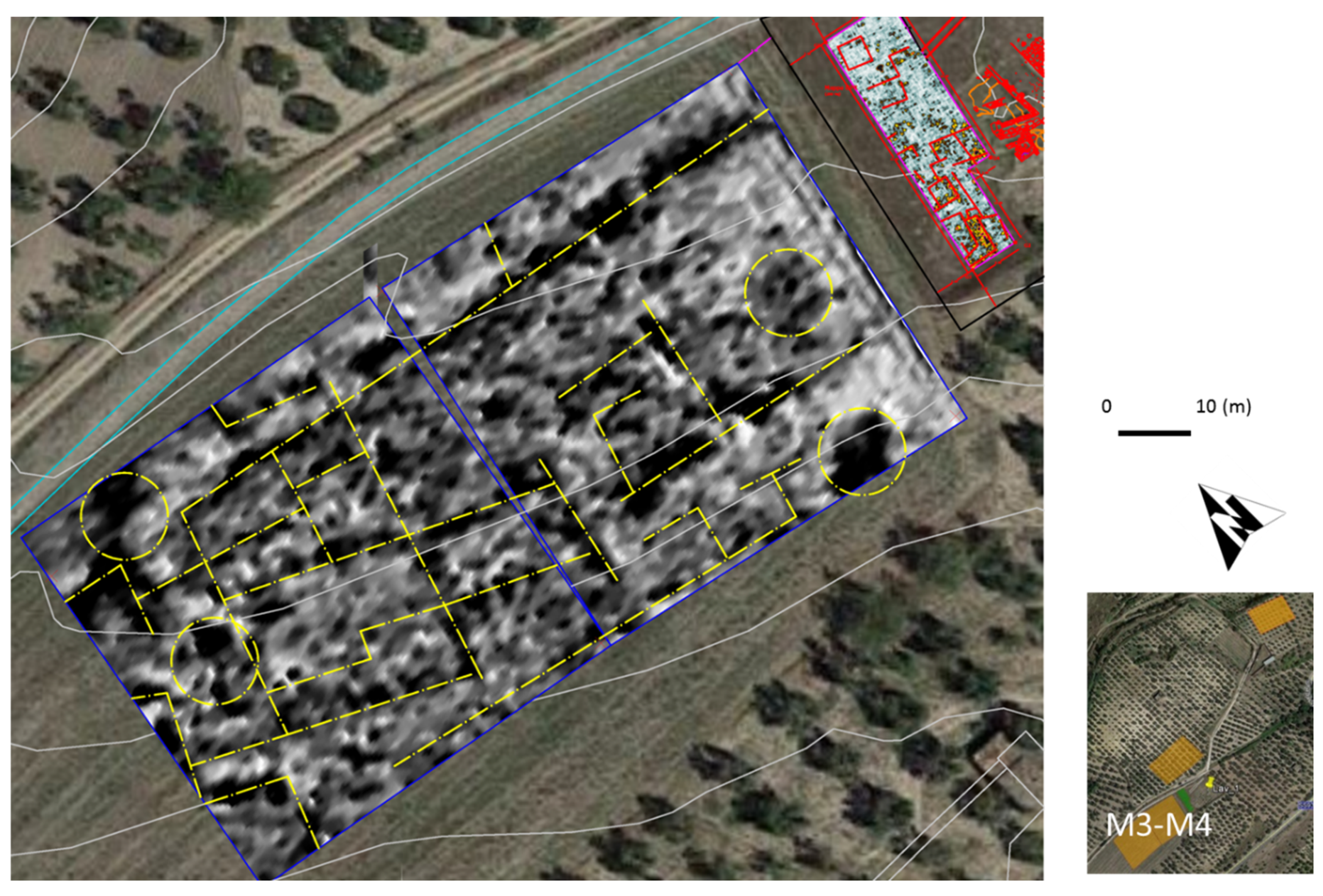
The last area investigated is placed to the west side of the archaeological area, and is made up of level ground and an absence of agricultural exploitation. This area was investigated with the creation of two different image maps, both of sized 50 m × 50 m. The results obtained, shown in Figure 8a,b, identify a complex settlement composed of large structures comparable, with respect to the sizes and distribution of the internal spaces, to those that have been excavated in the immediate area. By analyzing the geophysical results, it is possible to suppose that these anomalies, considering their dimensions and orientations, belong to more than one structure. It is likely that they are the remains of two or three Roman houses, whose existence had never been considered. By looking at the distribution of the magnetic events, it is obvious that the structures continue beyond the south side of the investigated area.
4.2. GPR Results
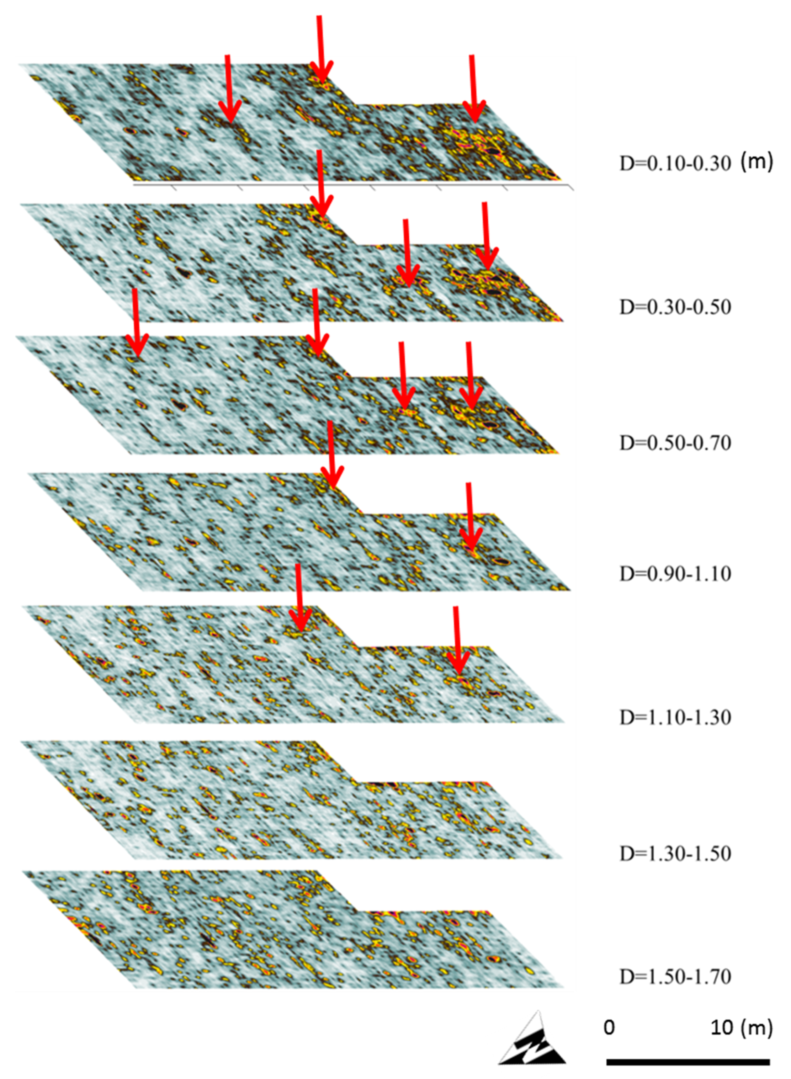
The GPR radargrams provide information about the electromagnetic anomalies distributed over the entirety of the investigated area. The presence of collapsed structures and surface irregularities have generated a lot of false readings. However, using a 3D representation of the e-m behavior of the subsoil, it is possible to identify some interesting reflective areas associated with walls or structures in the same orientation as those excavated by archaeologists. Figure 9 presents the results obtained at different depths in area G1—red arrows are used to highlight the most important reflections, possibly generated by buried walls. The most significant reflections are distributed in the first meter as demonstrated by the results, and corresponding with the structures already visible.
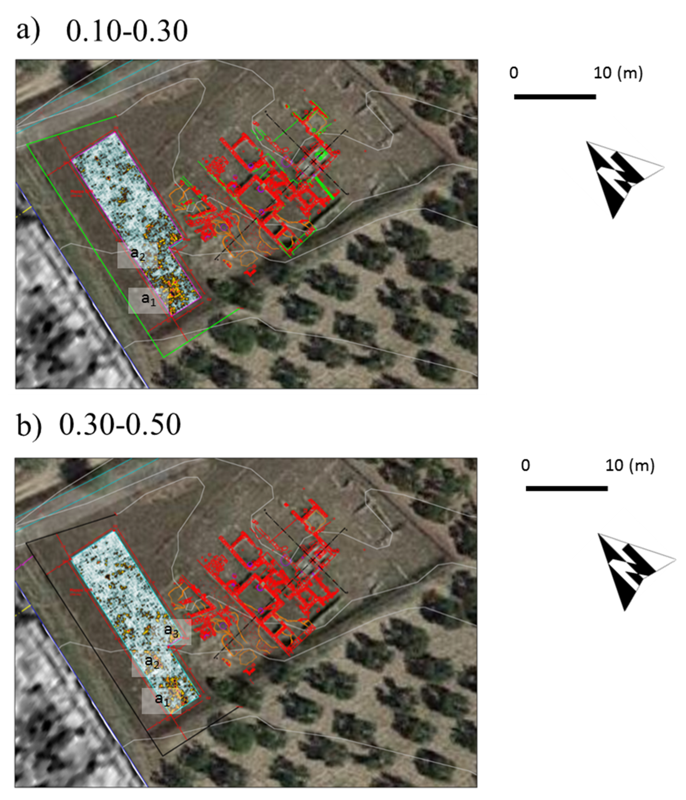
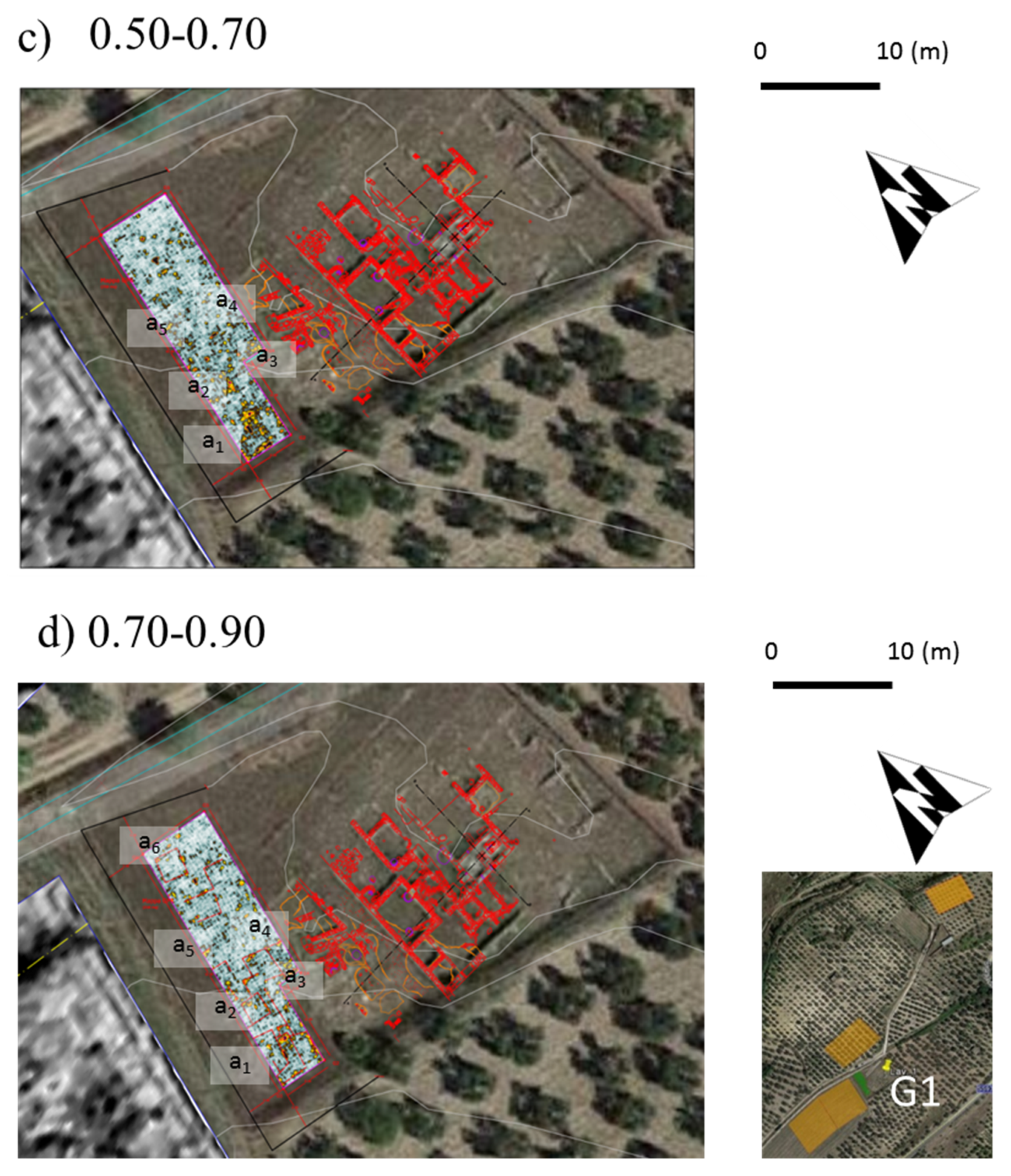
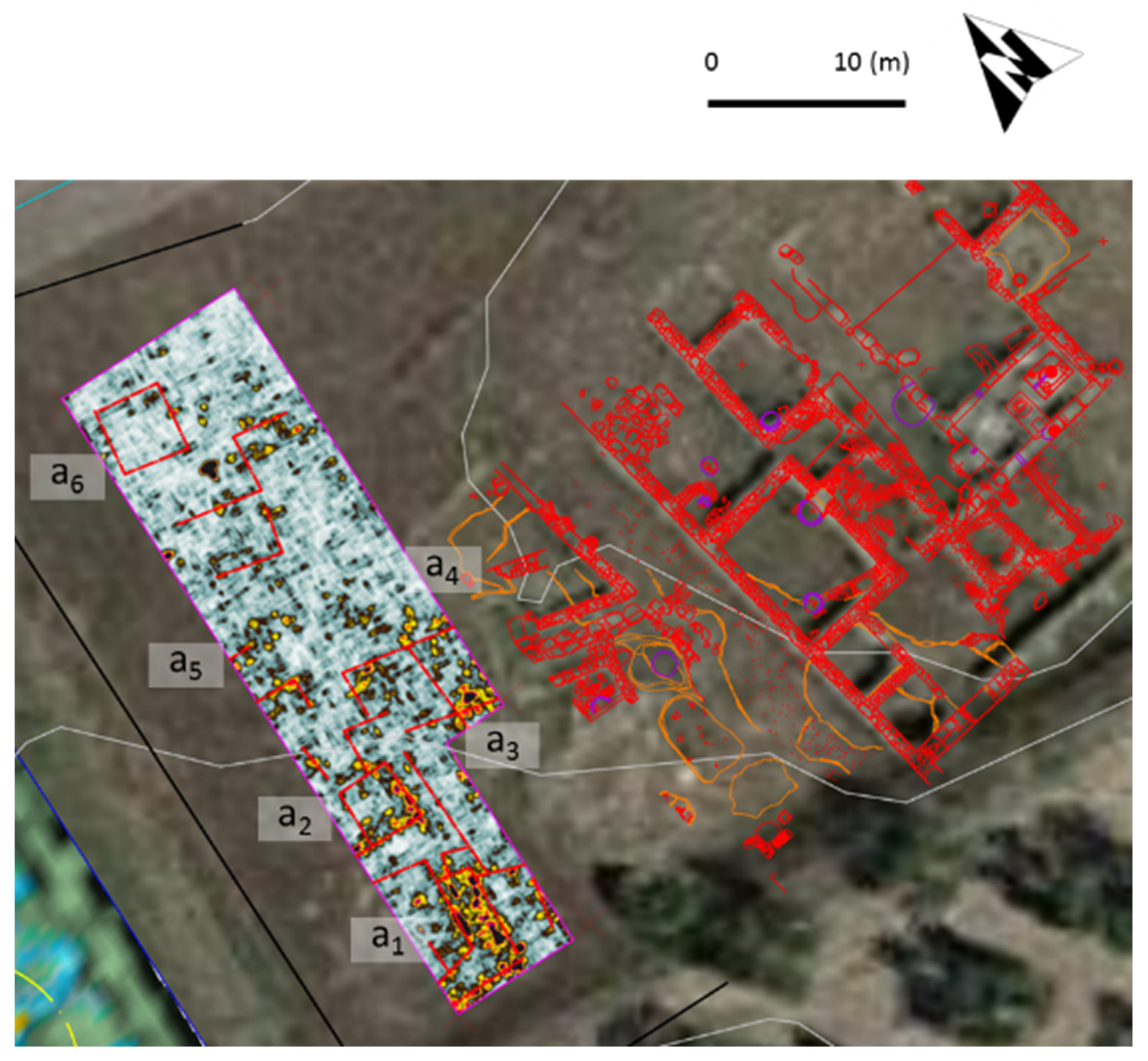
In Figure 10, the more interesting depth slices are superimposed on the plan of the site in the form of a georeferenced image. The strong relationship between the reflective areas with the buried structures, in particular in the south side of the map near the enclosure, is marked. As indicated in Figure 10, anomalies a3 and a4, located at depths greater than 0.50 m, seem to be extensions of walls belonging to the western structures, while anomalies a1, a2, a5, and a6 could be due to the presence of other walls of the same buildings.
5. Discussion
With respect to area M1, the orientation of the traces seems to suggest the presence of structures inclined at 15–20° in a north–south direction, and the anomalies indicate a discontinuity in the upper zone compatible with the presence of a road or, more likely, a courtyard between the agricultural buildings. A strong anomaly is recorded in the lower left corner of the map, where the possibility of the presence of walls was detected during the survey (see Figure 11). The magnetic anomalies detected in M2 are compatible with massive structures typical of retaining walls enclosing agricultural terraces. Some shorter anomalies are perpendicularly connected to the main anomalies on the map. The results suggest the presence of some spine walls used for reinforcing the terracing structures.
M3 and M4 present significant results for magnetic acquisitions in the area, demonstrating how powerful the method can be in slightly varying contexts, and exemplified by the relevant geophysical contrasts shown in Figure 12. The magnetic anomalies indicate the presence of a complex settlement including two or three structures, in which a regular pattern of walls and rooms (or courtyards) is clearly visible.
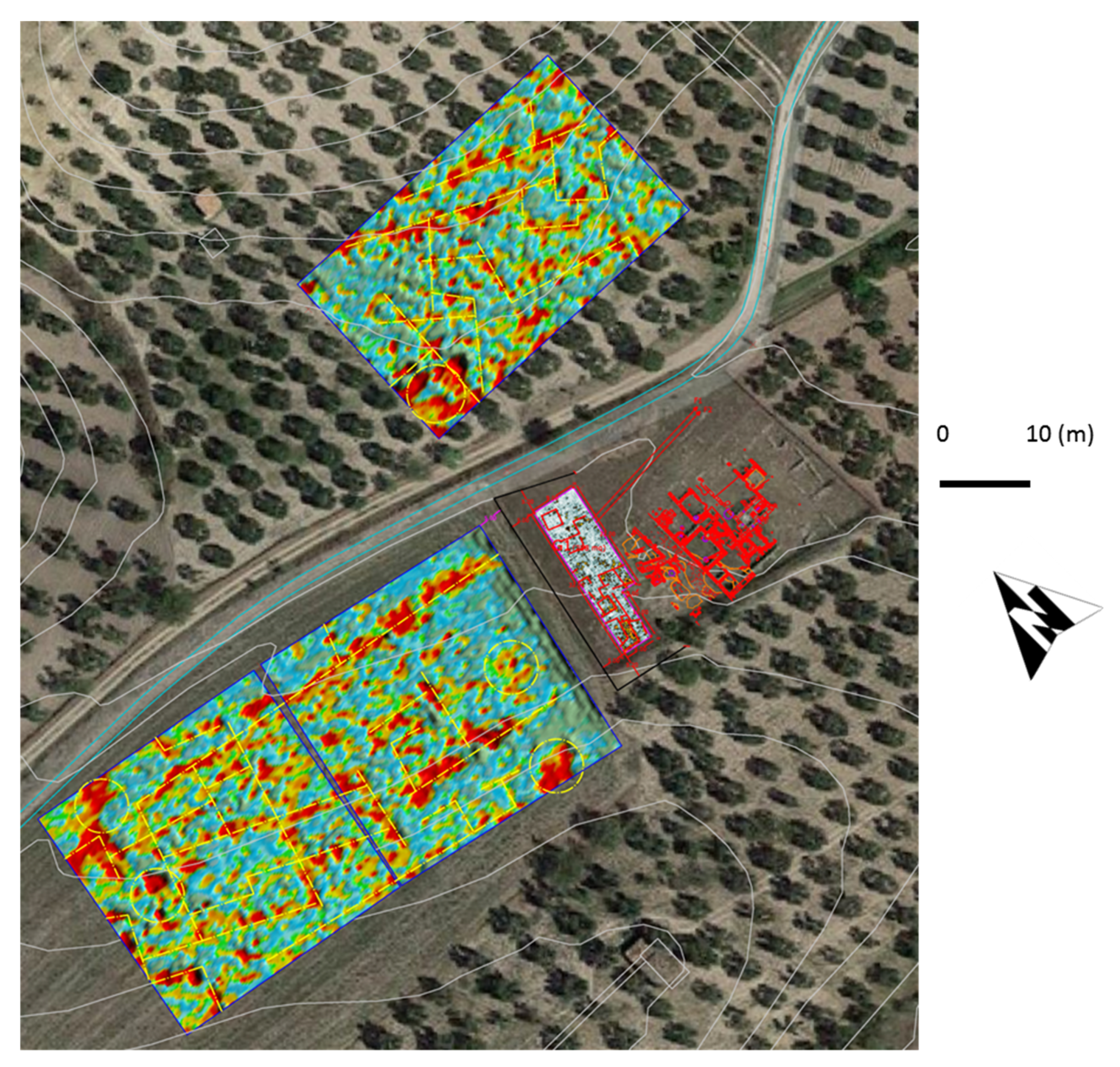
As expected, some corresponding alignments with the existing structures can be identified in the high-resolution GPR radargrams, and it is feasible that all of the geophysical anomalies can be associated with structures close to the ancient sanctuary. However, the limited zone investigated does not provide sufficient information to identify the extent of the structure. Figure 13 shows the comparison between the GPR depth slice obtained at depths of 0.30–0.50 m (on the left), and the existing structures (on the right). The most reflective areas, located in the shallower part of the subsoil and labelled a1 and a2 in Figure 13, suggest the presence of small rooms. Similar reflections indicate anomalies at a5 and a6.
6. Conclusions
The geophysical surveys conducted on the Gravetta hill are part of the exhibition project "Forentum Ritrovato", which opened in December 2017 at the Museo Civico di Lavello. The exhibition was the story of the territory of Lavello. The narrative and exhibition itinerary conclude at the point when the territory became Romanized, a phase during which the town seems to have centered around Gravetta, currently dominated by the archaeological area of the sanctuary. It was considered appropriate to enrich the Gravetta section of the exhibition by updating the available data of the area through geophysical survey, to apply new scientific data to the project, and to include a display of the latest methods used in preventive archaeology. The geophysical investigations have confirmed and strengthened the hypothesis; a series of highlighted anomalies suggests the presence of urban elements, identifiable by the roughly quadrangular structures in organized, regular patterns similar to those found in the already-excavated site of the sanctuary located in the immediate vicinity.
The archaeogeophysical activities have demonstrated that only a fraction of the history of Forentum is known. Indeed, the exploration of the area has confirmed that, in all likelihood, the site hides a complex Roman settlement including roads, houses, and courtyards. However, the interpretation made using the geophysical results will require much effort from archaeologists in order to validate the geophysical data affected by the uncertainties caused by modifications to the area, principally those that are the result of human activities in the recent past.
As shown, the geophysical results presented in this paper are impressive, particularly those in areas M3 and M4 on the west of the area. Here, thanks to some favorable conditions, in primis non-invasive agricultural activities and limited looting operations, MAG has allowed for the discovery of a complex, Roman-age settlement composed of two or three distinct structures characterized by their alignment with and similar orientation to the existing structures.
Very positive results were also obtained in M2, where rural activities were undertaken, identifying some interesting anomalies that could be associated with supporting walls or similar structures. Only in M1, where the subsoil has been disturbed by more recent, invasive human activity, has MAG not allowed for the discovery of clear anomalies. In these situations, the identification of well-organized structures is problematic. The presence of strong fragmentation does not allow for the detection of structures or walls as is possible in the other analyzed situations.
GPR investigation, realized in a small area adjacent to the existing archaeological site, has identified shallow alignments that suggest the continuation of the existing walls. The presence of an irregular surface, in some cases characterized by outcropping materials, has resulted in the generation of reflections in the readings that could either hide the presence of structures, or identify, with absolute certainty, alignments corresponding to archaeological remains.
As demonstrated in this paper, GPR and MAG have effectively detected archaeological structures, allowing us to shed light on the important past in the Roman age of the area. The results reveal clearly that the Gravetta site is much more extensive than the one known until now, and the necessity of a new perspective, which aims to further improve the knowledge of the entire complex of settlements, has been established. The activities, realized on only a small area of the entire site of Gravetta, will be completed by undertaking extensive investigations with GPR in the locations shown on maps M3 and M4 in order to confirm and enhance the quality of the data offered by MAG. Following this, archaeological excavations, supported by geophysical results, will be realized in areas where the results are more promising.
Author Contributions
Conceptualization: M.G.L., S.M., G.D.M. and L.C.; Methodology: L.C. and G.D.M.; Processing and Interpretation: L.C. and G.D.M.; Investigation: L.C. and G.D.M.; Validation: M.G.L. and S.M. Data Curation: L.C.; Writing-Original Draft: L.C., G.D.M. and S.M.; Writing-Review & Editing: L.C.; Visualization: L.C.; Supervision: L.C., S.M. and M.G.L.
Funding
This research received external funding by the municipal administration of Lavello (PZ) and the Basilicata Region.
Acknowledgments
All of this was possible thanks to the contributions of the municipal administration of Lavello (PZ); to the trust and support of the Superintendence of Archeology, Fine Arts, and Landscape; and the Pole Museum of Basilicata, to the involvement of local scholars such as Angelo Bottini, Maria Luisa Marchi, and Ada Preite. A special thanks to the cultural association MAC (Movement Art and Culture), which manages the local museum. The authors especially thank the private company Nostoi srl, supported by Tomogea srl, for helping us successfully complete the activities described in the paper. The authors are deeply grateful to Chloé Salisbury for improving the English writing of the manuscript.
Conflicts of Interest
The authors declare no conflict of interest.
References
- Rizzo, E.; Capozzoli, L. Integrated Geophysical Techniques for Archaeological Remains: Real Cases and Full Scale Laboratory Example. In Archaeogeophysics; El-Qady, G., Metwaly, M., Eds.; Springer: Berlin, Germany, 2019; Chapter 13. [Google Scholar] [CrossRef]
- Butzer, K.W. Challenges for a cross-disciplinary geoarchaeology: The intersection between environmental history and geomorphology. Geomorphology 2008, 101, 402–411. [Google Scholar] [CrossRef]
- Eppelbaum, L.V. Study of magnetic anomalies over archaeological targets in urban environments. Phys. Chem. Earth, Parts A/B/C 2011, 36, 1318–1330. [Google Scholar] [CrossRef]
- Lapenna, V. Resilient and sustainable cities of tomorrow: The role of applied geophysics. Boll. Geof. Teor. Appl. 2017, 58, 237–251. [Google Scholar] [CrossRef]
- Batayneh, A.T. Archaeogeophysics-archaeological prospection—A mini review. J. King Saud Univ. Sci. 2011, 23, 83–89. [Google Scholar] [CrossRef]
- Campana, S.; Piro, S. Seeing the Unseen—Geophysics and Landscape Archaeology; CRC Press: London, UK, 2009; p. 376. ISBN 978-0-415-44721-8. [Google Scholar]
- Masini, N.; Capozzoli, L.; Chen, P.; Chen, F.; Romano, G.; Lu, P.; Tang, P.; Sileo, M.; Ge, Q.; Lasaponara, R. Towards an operational use of Remote Sensing in Archaeology in Henan (China): Archaeogeophysical investigations, approach and results in Kaifeng. Remote Sens. 2017, 9, 809. [Google Scholar] [CrossRef]
- Masini, N.; Capozzoli, L.; Romano, G.; Sieczkowska, D.; Sileo, M.; Bastante, J.; Astete Victoria, F.; Ziolkowski, M.; Lasaponara, R. Archaeogeophysical based approach for Inca archaeology. Surv. Geophys. 2018. [Google Scholar] [CrossRef]
- Rizzo, E.; Santoriello, A.; Capozzoli, L.; De Martino, G.; De Vita, C.B.; Musmeci, D.; Perciante, F. Geophysical survey and archaeological data at Masseria Grasso (Benevento, Italy). Surv. Geophys. 2018. [Google Scholar] [CrossRef]
- Leucci, G.; Masini, N.; Rizzo, E.; Capozzoli, L.; De Martino, G.; De Giorgi, L.; Marzo, C.; Roubis, D.; Sogliani, F. Integrated archaeogeophysical approach for the study of a medieval monastic settlement in Basilicata. Open Archaeol. 2015, 1. [Google Scholar] [CrossRef]
- Daniels, D. Ground Penetrating Radar, 2nd ed.; IEE Press: London, UK, 2004. [Google Scholar]
- Catapano, I.; Affinito, A.; Gennarelli, G.; Di Maio, F.; Loperte, A.; Soldovieri, F. Full three-dimensional imaging via ground penetrating radar: Assessment in controlled conditions and on field for archaeological prospecting. Appl. Phys. 2014, 115, 1415–1422. [Google Scholar] [CrossRef]
- Goodman, D.; Piro, S. GPR Remote Sensing in Archaeology; Springer: Berlin, Germany, 2013; Volume 9, ISBN 978-3-642-31856-6. [Google Scholar]
- Ludeno, G.; Capozzoli, L.; Rizzo, E.; Soldovieri, F.; Catapano, I. A microwave tomography strategy for underwater imaging via Ground Penetrating Radar. Remote Sens. 2018, 10, 1410. [Google Scholar] [CrossRef]
- Capozzoli, L.; Caputi, A.; De Martino, G.; Giampaolo, V.; Luongo, R.; Perciante, F.; Rizzo, E. Electrical and electromagnetic techniques applied to an archaeological framework reconstructed in laboratory. In Proceedings of the 8th International Workshop on Advanced Ground Penetrating Radar (IWAGPR), Florence, Italy, 7–10 July 2015. [Google Scholar] [CrossRef]
- Piro, S.; Sambuelli, L.; Godio, A.; Taormina, R. Beyond image analysis in processing archaeomagnetic geophysical data: Case studies of chamber tombs with dromos. Near Surf. Geophys. 2007, 5, 405–414. [Google Scholar] [CrossRef]
- Fedi, M.; Cella, F.; Florio, G.; Manna, M.L.; Paoletti, V. Geomagnetometry for Archaeology. In Sensing the Past; Masini, N., Soldovieri, F., Eds.; Springer: Cham, Switzerland, 2017; Volume 16. [Google Scholar]
- Bozzo, E.; Lombardo, S.; Merlanti, F.; Pavan, M. Integrated geophysical investigations at an etrurian settlement in Northern Apennines (Italy). Archaeol. Prospect 1994, 1, 19–35. [Google Scholar] [CrossRef]
- Dabas, M.; Anest, A.; Thiesson, J.; Tabbagh, A. Slingram EMI Devices for Characterizing Resistive Features Using Apparent Conductivity Measurements: Check of the DualEM421S Instrument and Field Tests. Archaeol. Prospect. 2016, 12, 165–180. [Google Scholar] [CrossRef]
- Viberg, A.; Berntsson, A.; Lidén, K. Archaeological prospection of a high altitude Neolithic site in the Arctic mountain tundra region of northern Sweden. J. Archaeol. Sci. 2013, 40, 2579–2588. [Google Scholar] [CrossRef]
- Rizzo, E.; Masini, N.; Lasaponara, R.; Orefici, G. ArchaeoGeophysical methods in the Templo del Escalonado (Cahuachi, Nasca, Perù). Near Surf. Geophys. 2010, 8, 433–439. [Google Scholar] [CrossRef]
- Trinks, I.; Neubauer, W.; Hinterleitner, A. First high-resolution GPR and magnetic archaeological prospection at the Viking age settlement of Birka in Sweden. Archaeol. Prospect. 2014, 21, 185–199. [Google Scholar] [CrossRef]
- Diamanti, N.G.; Tsokas, G.N.; Tsourlos, P.I.; Vafidis, A. Integrated interpretation of geophysical data in the archaeological site of Europos (northern Greece). Archaeol. Prospect. 2005, 12, 79–91. [Google Scholar] [CrossRef]
- Chianese, D.; Lapenna, V.; Di Salvia, S.; Perrone, A.; Rizzo, E. Joint geophysical measurements to investigate the Rossano of Vaglio archaeological site (Basilicata Region, Southern Italy). J. Archaeol. Sci. 2010, 37, 2237–2244. [Google Scholar] [CrossRef]
- Rizzo, E.; Chianese, D.; Lapenna, V. Magnetic, GPR and geoelectrical measurements for studying the archaeological site of ‘Masseria Nigro’ (Viggiano, southern Italy). Near Surf. Geophys. 2005, 3, 13–19. [Google Scholar] [CrossRef]
- Sdao, F.; Simeone, V. Mass movements affecting goddess Mefitis sanctuary in Rossano di Vaglio (Basilicata, Southern Italy). J. Cult. Herit. 2007, 8, 77–80. [Google Scholar] [CrossRef]
- Bavusi, M.; Chianese, D.; Giano, S.I.; Mucciarelli, M. Multidisciplinary investigations on the Roman aqueduct of Grumentum (Basilicata-Southern Italy). Ann. Geophys. 2004, 6, 1791–1802. [Google Scholar]
- Chianese, D.; D’Emilio, M.G.; Di Salvia, S.; Lapenna, V.; Ragosta, M.; Rizzo, E. Magnetic mapping, Ground Penetrating Radar surveys and magnetic susceptibility measurements for the study of the archaeological site of Serra di Vaglio (Southern Italy). J. Archaeol. Sci. 2004, 5, 633–643. [Google Scholar] [CrossRef]
- Bavusi, M.; Bianca, M.; Izzi, F.; Di Leo, P.; Parisi, S.; Pulice, I.; Schiattarella, M. Methods and Technologies for the Cultural Heritages in Basilicata region: A case-study from the coastal belt of Metapontum. Rend. Online Soc. Geol. 2015, 34, 101–106. [Google Scholar] [CrossRef]
- Ciminale, M.; Ricchetti, E. Non-destructive exploration in the Archaeological Park of Metaponto (Southern Italy). Archaeol. Prospect. 1999, 6, 75–84. [Google Scholar] [CrossRef]
- Di Lieto, M.; Rizzo, E.; De Martino, G. Metodologie di indagine diversificate e nuove prospezioni geofisiche. In Lo Spazio del Potere; Osanna Edizioni: Venosa PZ, Italy, 2009; pp. 227–232. [Google Scholar]
- Fresa, M.P. Lavello, Gravetta-Santuario; Da Leukania a Lucania. La Lucania centro orientale tra Pirro e I Giulio-Claudii: Roma, Italy, 1993; pp. 16–17. [Google Scholar]
- Chelotti, M. Supplementa Italica, n. s. 20; Edizioni Quasar: Rome, Italy, 2003. [Google Scholar]
- Marchi, M.L. Ager Venusinus II (Forma Italiae 43); Leo S. Olschki Editore: Florence, Italy, 2010. [Google Scholar]
- Marchi, M.L. Settlement dynamics of Romanization. In Proceedings of the IV International Congress of Veleiat Studies, Velelia, Italy, 20–21 September 2013; pp. 265–278. [Google Scholar]
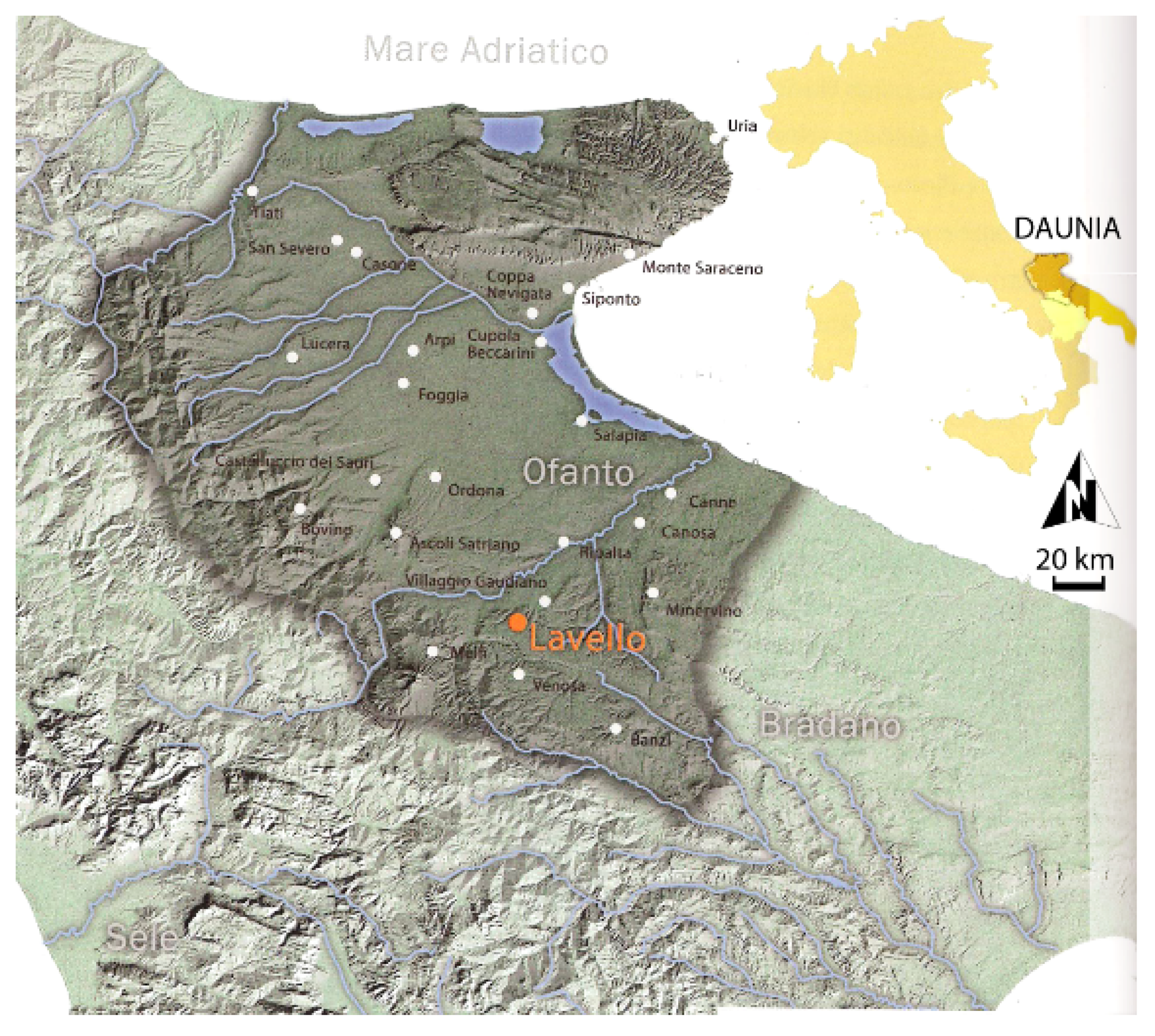
Figure 1.
The location of the settlement of Lavello in the ancient Daunian territory.

Figure 2.
The relationship between the archaeological sites of Forentum and Canosa near the Vulture Volcano (Google Earth satellite image).
Figure 2.
The relationship between the archaeological sites of Forentum and Canosa near the Vulture Volcano (Google Earth satellite image).

Figure 3.
Aerial photo of the archaeological site of Gravetta with indication of the most important features characterizing the sanctuary.
Figure 3.
Aerial photo of the archaeological site of Gravetta with indication of the most important features characterizing the sanctuary.

Figure 4.
Scheme of geophysical acquisition adopted in the area of Gravetta (Lavello).

Figure 5.
Geophysical readings at the site of Forentum; most of the area investigated is characterized by its olive groves (a) and was investigated using a ground penetrating radar (GPR) mounted on a cart (b), while in (c), the cesium vapor magnetometer used for the gradiometric configurations (MAG) readings is analyzing position M3 on the map.

Figure 6.
MAG maps acquired in correspondence to the area M1 (e), in false color (a), and in grey scale (b), superimposed on a satellite image (Google Earth 2018) (c,d) with the most interesting alignments indicated with yellow lines.
Figure 6.
MAG maps acquired in correspondence to the area M1 (e), in false color (a), and in grey scale (b), superimposed on a satellite image (Google Earth 2018) (c,d) with the most interesting alignments indicated with yellow lines.

Figure 7.
MAG maps acquired relating to the area M2 (e), in false color (a), and in grey scale (b), superimposed on satellite image (Google Earth 2018) (c,d) with the most interesting alignments identified with yellow lines.
Figure 7.
MAG maps acquired relating to the area M2 (e), in false color (a), and in grey scale (b), superimposed on satellite image (Google Earth 2018) (c,d) with the most interesting alignments identified with yellow lines.

Figure 8.
MAG maps acquired relating to area M4 (e), in false color (a), and in grey scale (b), superimposed on a satellite image (Google Earth 2018) (c,d) with the most interesting alignments identified with yellow lines.
Figure 8.
MAG maps acquired relating to area M4 (e), in false color (a), and in grey scale (b), superimposed on a satellite image (Google Earth 2018) (c,d) with the most interesting alignments identified with yellow lines.

Figure 9.
GPR depth slices extracted from the 3D model of area G1, with red arrows indicating the more interesting reflections in the first meter investigated.
Figure 9.
GPR depth slices extracted from the 3D model of area G1, with red arrows indicating the more interesting reflections in the first meter investigated.

Figure 10.
Overlay of the depth slices extracted in area G1 at depths ranging between 0.10–0.30 m (a), 0.30–0.50 m (b), 0.50–0.70 m (c), and 0.70–0.90 m (d).
Figure 10.
Overlay of the depth slices extracted in area G1 at depths ranging between 0.10–0.30 m (a), 0.30–0.50 m (b), 0.50–0.70 m (c), and 0.70–0.90 m (d).


Figure 11.
Geophysical results obtained in the immediate vicinity of the archaeological site of Forentum.
Figure 11.
Geophysical results obtained in the immediate vicinity of the archaeological site of Forentum.

Figure 12.
Archaeomagnetic anomalies corresponding to archaeological structures near the excavated areas. Yellow lines identify the presence of walls, while the circles indicate potential anomalies from collapsed structures or the accumulation of ferro-magnetic materials.
Figure 12.
Archaeomagnetic anomalies corresponding to archaeological structures near the excavated areas. Yellow lines identify the presence of walls, while the circles indicate potential anomalies from collapsed structures or the accumulation of ferro-magnetic materials.

Figure 13.
Electromagnetic anomalies recorded at all depths superimposed on the slice corresponding to a depth of 0.30–0.50 m with possible buried structures identified with red lines. At the eastern side, it is possible to see the position of the excavated archaeological site.
Figure 13.
Electromagnetic anomalies recorded at all depths superimposed on the slice corresponding to a depth of 0.30–0.50 m with possible buried structures identified with red lines. At the eastern side, it is possible to see the position of the excavated archaeological site.

© 2019 by the authors. Licensee MDPI, Basel, Switzerland. This article is an open access article distributed under the terms and conditions of the Creative Commons Attribution (CC BY) license (http://creativecommons.org/licenses/by/4.0/).
Share and Cite
MDPI and ACS Style
Capozzoli, L.; Mutino, S.; Liseno, M.G.; De Martino, G. Searching for the History of the Ancient Basilicata: Archaeogeophysics Applied to the Roman Site of Forentum. Heritage 2019, 2, 1097-1116. https://doi.org/10.3390/heritage2020072
AMA Style
Capozzoli L, Mutino S, Liseno MG, De Martino G. Searching for the History of the Ancient Basilicata: Archaeogeophysics Applied to the Roman Site of Forentum. Heritage. 2019; 2(2):1097-1116. https://doi.org/10.3390/heritage2020072
Chicago/Turabian StyleCapozzoli, Luigi, Sabrina Mutino, Maria Grazia Liseno, and Gregory De Martino. 2019. "Searching for the History of the Ancient Basilicata: Archaeogeophysics Applied to the Roman Site of Forentum" Heritage 2, no. 2: 1097-1116. https://doi.org/10.3390/heritage2020072