1. Introduction
After the uprising of General Franco’s troops against the Government of the Spanish Republic in July 1936, the Spanish Civil War (1936–1939) spread rapidly throughout the peninsular territory, splitting the country into two factions. In November of that same year, the pressure of the troops in Madrid caused the Government of the Republic to move to Valencia, making this region especially vulnerable [
1]. The new war strategies and the possibilities offered by modern weaponry forced the Government to design a defense program to protect the civilian population from attacks received by land, sea, or air [
2].
In 1937, after the successive airplane attacks directed by the nationalist faction from the island of Mallorca [
3], the Republican Government ordered the construction of a defense network, located at strategic points in the proximity of port infrastructures and inlets propitious for the landing of enemy troops. This network was organized on two levels: bunkers proliferated at lower heights, based mainly on the burial of the positions and the use of reinforced concrete [
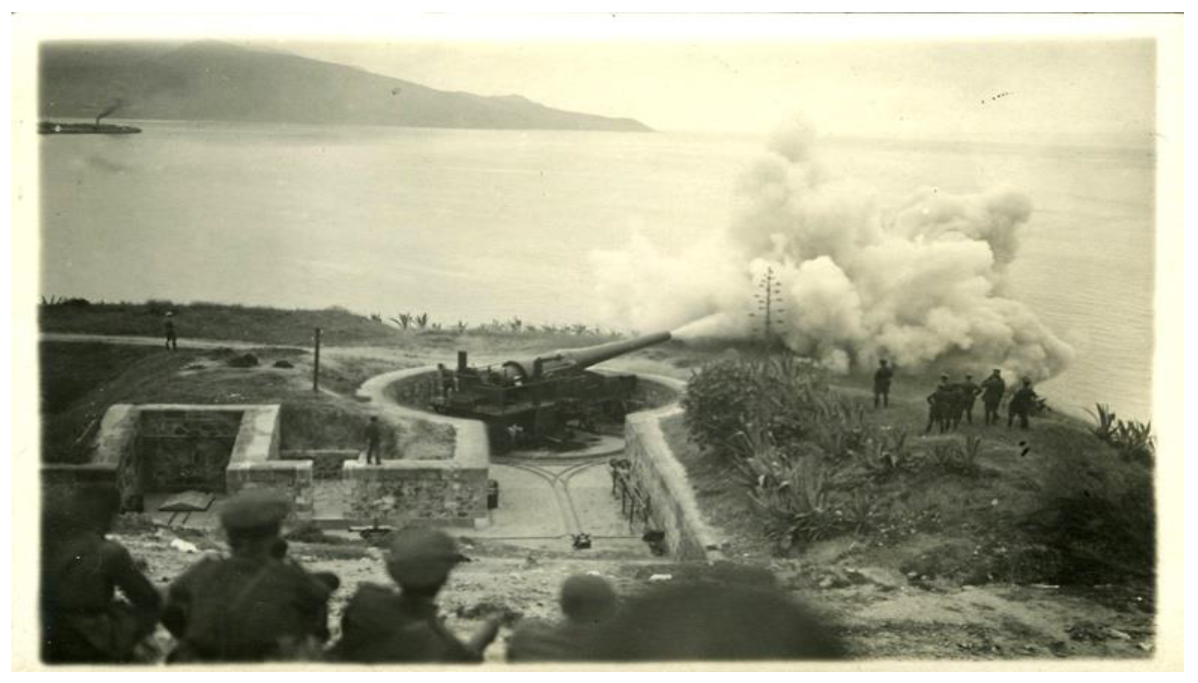
4]; anti-aircraft batteries at higher positions, constructed with masonry and reinforced concrete. Among the elements used to integrate the second defense front, coastal batteries were very common.
In general, coastal batteries were constituted by a circular platform, delimited along almost the entire perimeter by a masonry wall. The armament was anchored on a metallic structure in the center of the platform, with the possibility of turning, allowing covering 360° to be able to follow the trajectory of enemy airplanes. The diameter of these platforms ranged between 3 and 15 m. A key component of defense was the construction of a front parapet housing two niches underneath: one for storing gunpowder and the other for storing ammunition (
Figure 1). Next to the anti-aircraft batteries, other constructions were erected, such as the gunpowder magazine, protection and shelter areas for the troops, or the command and observation post, always located in the rear. In addition, there were light reflectors for night attacks, machine gun nests, or even trench nets close to them [
4].
Anti-aircraft batteries are not only found at sites on the Mediterranean coast, but are also spread along the entire peninsular coast, the Galician estuaries, and the Canary and Balearic archipelagos. Despite the number of such constructions, studies on the subject are scarce, with the exception of the work carried out on the coasts of Alicante [
3,
5] and Cádiz [
6,
7], where a great deal of documenting work has been performed.
What happened in Spain during the Civil War was the prelude of what would happen later on in Europe. The outbreak of World War II urged the German army to build fortifications, bunkers, and defense positions along 5000 km of the Atlantic coast, forming what was known as the
Atlantikwall [
8], which extended from the north of Norway to the south of France, passing through countries such as Denmark, the Netherlands, and Belgium, where today it is still possible to visit some of these constructions.
Today, this type of architecture has little social recognition as it brings back memories of an era of war and violence that is still too recent. It is considered an uncomfortable heritage, as classified by some authors [
5], scarcely studied and valued and, for many, devoid of aesthetic sense, which makes it a vulnerable heritage, being also scattered, hidden, and often located at places of difficult access, contributing even more to its abandonment. In spite of this, it is part of our history since the use of reinforced concrete marked a turning point in architectural solutions by granting new possibilities that until then had been impossible.
In Europe, in recent years, we find actions aimed at the enhancement of the most recent war heritage. This is the case of Norway, where there was a proposal to reuse civil defense shelters for food storage and even as entertainment and recreation spaces [
9]. On the Dutch coast, numerous bunkers buried in the sand have been recovered and opened to the public, which are visited by tourists during the so-called “Bunker Day”. Moreover, in Scotland, there is a growing interest in the reuse of buried constructions, once conceived for defense military purposes during the Cold War [
10].
On the Spanish coast, we can find some reuse initiatives and/or enhancement work of military structures from the Civil War. For instance, the defense complex of Turó de la Rovira [
11], in Barcelona, consisting of a pavilion for officers and another for the troops, in addition to an anti-aircraft battery with a command post now turned into a city lookout, was recovered and musealized. In the Strait of Gibraltar, the City Council of La Línea de la Concepción initiated, two decades ago, a project aimed at restoring and recovering its military heritage.
In the Valencian Community, public administrations have also become aware in the past years of the historical importance of this heritage, making key decisions regarding its protection, recovery, conservation, and enhancement. The most relevant intervention was the declaration of this war heritage as an Asset of Local Relevance (ALR) and its subsequent inclusion in
Section 2 of the General Inventory of Valencian Cultural Heritage [
12]. Recently, in some places such as Valencia, Alicante, or Burriana, several bunkers and/or shelters have been intervened and musealized, opening them to visitors. In other instances, some tourist routes and guided tours have been created, such as the bunker route at the towns of Nules or El Puig. In Cullera, since 2010, the City Council has carried out a policy of conservation and recovery of the Civil War military architectural heritage, as exemplified by the “Project of recovery, restoration, and enhancement of the Market’s Air-Raid Shelter”. Currently, this shelter acts as a Civil War Museum and is one of the most visited spaces of the Local Museums of the Cullera network.
Following this trend, in recent months, the City Council of Cullera has participated in the call for “Aid for the implementation of actions related to the historical and democratic memory of Valencia, the enhancement of places of memory, and removal of vestiges relating to the Civil War and the end of the dictatorship”, convened by the Department of Participation, Transparency, Cooperation, and Democratic Quality, of the Generalitat Valenciana. The work to be carried out for the recovery of the defensive architecture of Cullera’s Cape is part of this call for aid.
3. General Framework of the Investigation
On 8 August 1936, the Sucrona magazine of Cullera, issue 720 [
19] published the news of the outbreak of the Spanish Civil War. From that moment, the municipal authority was replaced by a committee of the Popular Front: collectivization and clashes between syndicates took place, the hospital was enabled as a Military Hospital to which evacuees from the occupied areas began to arrive, and both active defense (concentrated on the coast, lighthouse, and beaches) and passive defense (focused on the construction of air-raid shelters) were organized, planning three types of actions:
1.
Construction of bunkers or air-raid shelters: four air-raid shelters were built in Cullera, one in each neighborhood, as part of the passive defense. Although the beginning of their construction was delayed, the bombing of the railway station and the bridges of Cullera in November 1938 accelerated their construction [
20]. In spite of this, the war was coming to an end, and these constructions remained unfinished.
2.
Construction of coastal defense structures: within the active defense, several military defense structures were built on the Levantine coast, from Sagunto to Denia, with anti-aircraft batteries located in the towns of Canet, El Saler, and Cullera [
21]. Its objective was to face the attacks since first sighting, trying to prevent the landing of troops [
4] and, thus, protecting the Government of the Republic settled in Valencia.
3. Other facilities and infrastructures: several actions were carried out, such as the habilitation of the Hospital de la Sangre, which became part of the republican hospitals network, and the improvement of the railway network, reinforcing its strategic position in the exchange of goods and raw materials that were sent from Valencia to southern regions.
Several battalions and organizations of Cullera [
22] participated in these actions, being the Fortifications and Works Battalion, the one in charge of defending and fortifying the coast, as well as taking responsibility for the construction of the cape’s defense structures and the coastal casemates (
Figure 3).
Object of Study: The Defense Complex of the Cape of Cullera
Cullera’s Cape constitutes, for many reasons, a unique site on the coast of Valencia for the construction of this defense complex: (1) for its strategic position in the defense line of the Valencian coast, since it is the only geographical feature extending into the sea in the shoreline area between Sagunto and Denia, providing a visual field covering an arc of 180°; (2) because geographically it is a hill, allowing the construction of an elevated command post in the rear of the battery from which to look out for and warn of possible attacks; (3) for its location, south of Valencia and in front of the coast of the Balearic Islands, from where the allies of the nationalist faction took off to bombard the city.
The defense complex of Cullera’s Cape, known as “Coastal Defense Artillery Post No. 2”, is located to the south of Cullera’s lighthouse, on the Penya Alta, between the Punta de la Bancada and the Punta de Mascarell. It is composed of a battery close to the coast, as well as a command and observation post on the mound located just behind (
Figure 4). The ensemble was completed with the construction of artillery casemates scattered around the bay, located on the lighthouse’s beach, on the Racó beach, at the mouth of the River Júcar, and on the Marenyet beach, among other places [
20]. Currently, only a few vestiges remain.
4. Material and Methods
4.1. Graphic Documentation of Cullera’s Lighthouse
Technological progress in the field of graphic survey methods is contributing to the conservation of architectural heritage while allowing the acquisition of deeper knowledge of heritage assets and facilitating its dissemination [
23]. By means of 3D data acquisition techniques, it is possible to obtain a complete three-dimensional record, from which different products can be subsequently procured, ranging from three-dimensional photogrammetric models or colored point clouds to traditional graphic documentation data. In the field of architectural heritage, the most commonly used techniques are terrestrial laser scanning (TLS) and digital photogrammetry or structure from motion (SfM). However, in recent years, a new mobile mapping system (MMS) based on SLAM (simultaneous localization and mapping) technology is gaining importance, standing out for its ease of use and speed, as well as its possibility to access limited physical spaces, impossible for other technologies [
24].
In most cases, these techniques are not used by themselves, and it becomes necessary to employ a combination of them, which requires some expertise and adaptability [
25], since there are factors depending not only on the data acquisition technique chosen, but also on the conditions of the asset [
26] and the expected result. For instance, there have been cases in which, due to the difficulty of access to the site, it has been necessary to resort to a scanner-on-rails, making it possible to position it in remote locations without the need for an operator to travel with it [
27]. In other cases, the lack of indoor light leads to the use of a synchronized flash trigger to perform the photogrammetric survey [
28]. On other occasions, it is necessary to consider using a hybrid methodology [
29,
30,
31], allowing the combination of several methods [
32], as the best choice. In the work carried out on the unearthed friezes in the tunnels at the Archaeological Site of Holmul in Guatemala [
33], a comparison study was performed on the data acquired by means of a structured light scanner and a terrestrial laser scanner. Furthermore, in a recent study conducted on the Tholo of El Romeral, belonging to the Antequera dolmen site, three techniques were used, featuring a comparison between SLAM-based mobile mapping systems (MMS) and the already consolidated graphic recording systems such as TLS and SfM [
24].
In the case of the defense complex of Cullera’s Cape, the indoor lighting conditions and the size of the buried constructions required the graphic survey to rely on a hybrid methodology, combining active sensors techniques (TLS) for data acquisition with passive survey methods (SfM/IM). The work was carried out in two phases: one of in situ data collection guaranteed by the use of various techniques and equipment, and the other of desk-based work, in which the clouds were recorded, the photogrammetric models were obtained, and the necessary graphic documentation was elaborated for its subsequent analysis.
4.2. Terrestrial Laser Scanning (TLS)-Based Survey
For the project, a Leica RTC360 laser scanner was used, chosen on the basis of its high performance, reduced size (120 mm × 240 mm × 230 mm) and manageability (it weighed 5.35 kg, which facilitated moving around the galleries;
Figure 5). This scanner has a measuring rate of up to two million points per second, with a range of 0.5 m to 130 m, and a field of view of 360° horizontally and 300° vertically. To acquire the color information, the scanner integrates three 36 MP cameras, operating under an advanced HDR imaging system. The RTC360 has three scan resolutions: high (3 mm), medium (6 mm), and low (12 mm) at a 10 m radius. In this work, the high resolution was used in outer spaces, while, in the interior of the galleries, given the proximity to the walls and vaults, data acquisition was performed at medium resolution. A noteworthy feature is that it incorporates a system based on VIS (virtual inertial system) technology allowing field recording in an automated way, without the need for any support elements.
After analyzing the different sites, several factors were identified as potentially having a direct influence on the survey planning and programming. On the one hand, the narrowness of the passages and their linear nature meant that visual connectivity between scans would be poor, which prompted an increase in the number of scans. This same problem has also been faced when taking data in narrow streets in historical city centers [
34,
35]. On the other hand, the absence of light inside the gallery made both image capture and in situ scanning a complex task [
6]. Lastly, the state of abandonment of the underground constructions, full of debris, often made it difficult to park the equipment, slowing down data collection. In order to optimize and minimize the time of data collection, it was necessary to carefully plan the more suitable locations ahead of time [
36,
37]. In this regard, those investigations seeking to optimize the terrestrial laser scanning technique using simulated tunnel scans [
38,
39] are of great interest.
In the outer works, photographs were taken with the scanner’s integrated cameras to obtain the points’ RGB values, resulting in colored point clouds, while, for indoor data acquisition, the point cloud was taken without images due to the absence of light. The overlap between the interior and exterior was ensured by scanning at the thresholds of the accesses.
During the data acquisition phase, 58 scans of the battery were taken: 38 of them on the outside and 20 on the inside. Their recording generated a cloud composed of 337 million points with an overall accuracy of 3 mm, as a result of 61 links between stations, with a 50% overlap between point clouds (
Figure 6). In terms of the observation post, the same method was followed, requiring 32 scans: 12 in the interior and 20 in the exterior. The result was a cloud composed of 300 million points, with an overall accuracy of 2 mm, as a result of 27 links between stations, with a 51% overlap between clouds.
Once the clouds were registered and merged, three-dimensional models of the battery and the command post were obtained. In both cases, the merging of the clouds was fast thanks to the RTC360 visual inertial system. Only in some complex cases was it necessary to resort to manual alignment of the clouds. The software used was the Leica Cyclone REGISTER 360, which offers the possibility of creating sections of the model from parallelepiped-shaped boxes containing the cloud. Orthoimages were imported into AutoDesk’s AutoCAD software, and the different views were scaled and delineated, transforming them into architectural graphic documentation. In the end, a total of 34 vertical and four horizontal sections of the battery were obtained, in addition to six vertical and three horizontal sections of the command and observation post.
4.3. Survey by SfM/IM Photogrammetry
Today, thanks to recent advances in computer vision algorithms, there are automated procedures available capable of generating dense colored point clouds. This software improvement has brought the method closer to the user, acquiring great popularity in recent years, which has sometimes led to erroneous but apparent results, since the software is so user-friendly that it gives the false impression that it is a simple method [
26]. Thus, it is fundamental to implement a rigorous methodology in order to obtain accurate results.
The SfM/IM technique allows for 3D point cloud reconstruction of an object from a set of 2D images (photographs). The procedure starts with the extraction of features from the photographs (operated thanks to scale-invariant feature transform (SIFT) algorithms) which is followed by a higher-density matching operation (random sample consensus algorithm) to find a large number of corresponding points in the set of images. At this stage, homologous points are detected and can be projected in a 3D space thanks to a photogrammetric process. The result is a 3D point cloud in which each point shares the coordinate system and is allocated the RGB value. The point cloud generated can be processed to obtain a surface model integrated by triangular faces (polygonal mesh) and textured by projecting the images over the model itself (
Figure 7).
This system was used in order to determine the orthoimages serving as the basis for the wall analysis of the interiors of the constructions. The constraints for this survey were complex, mainly due to the complete absence of light and the reduced distance available to photograph the walls (1 m approximately). Given the impossibility of carrying electric power by cable, and initially discarding the use of a combustion engine for power generation, two methods were considered:
(a) Using two wireless flashes arranged at the camera sides;
(b) Working without lighting support.
In all cases, a Sony α7r camera was used, with a 36.4 MP full frame sensor, a Sony 28 mm f2 fixed focal length lens, and Godox V1 automated TTL compact flashes.
The results obtained, according to the first method based on the use of flashes, was very satisfactory. Uniform illumination was achieved, despite the short distance between the camera and the object, resulting in the absence of areas of uneven light intensity. In addition, placing the light sources at both sides provided a grazing illumination favoring an in-depth reading of the surface. Filters were used for wide-angle specific flashes, which, along with the use of the TTL system, ensured the correct lighting setup for the photographic shot.
In the second method, on the contrary, the distance between the camera and the object increased due to the space required for the tripod arrangement. In addition, due to the scarcity of light, long exposure periods were used to capture the shots. In consequence, despite the conditions described, the result was acceptable, although processing was needed to improve the lighting.
With this method without illumination, we also made an attempt to take pictures without using a tripod in order to improve the speed between shots. Surprisingly, high-quality snapshots were obtained, with almost imperceptible differences with respect to the use of the tripod. However, it was necessary to set a proper white balance and fix the ISO sensitivity at 6400 to reach a speed of 1/60 second and an exposure compensation of +0.7.
The orthoimages obtained had a 1 mm/pixel resolution, which could be even higher given the short distance to the object and the sensor’s high resolution. However, the established resolution was sufficient for the detailed analysis of the wall facing (
Figure 8).
5. Results
Following the graphic surveying, we undertook the study and analysis of each of the elements integrating this defense complex, as described below.
5.1. Anti-Aircraft Battery
From the results of the graphic survey of the battery remains (
Figure 9), located at an altitude of 35.75 m above sea level, it can be deduced that it was integrated by two circular platforms of approximately 8.50 m diameter each, with anchorages at the center to attach the artillery. The platforms were accessed through esplanades located on the opposite side of the sea. The remains allow observing that the southwest platform (platform A) is surrounded by a wall 0.55 m wide, reaching a 1 m thickness on the side facing the sea, indicating the place where the front parapet would have been located. Likewise, this platform is communicated with the viewpoint esplanade through a small passage 1.30 m wide located to the east, a space that would have possibly coincided with what was one of the storage niches at that time. There are no remains of the other niche. The second platform, located 27.75 m away from the first one in the direction 52° W (platform B), is much more changed than the first one. This one also has a 1.30 m wide passage, located to the south, connecting it with the viewpoint through a small stairway. The reading of these remains is more challenging, since the platform was converted some time ago into a playground, installing several swings on it. In this case, the wall surrounding it is 0.66 m wide, although the remains of the front parapet are not visible. Regarding the niches, there is a mark on one side of the wall, in the shape of a semicircular arch, which may coincide with the place where one of them was once located.
What has been preserved almost intact is the underground construction located underneath the battery. Through two accesses, one located practically to the west (access A) and the other to the northwest (access B) of the platforms, access is given to two 1.20 m wide galleries excavated in the mountain, which intersect in the gunpowder magazine.
The gallery departing from access A has a length of 23.90 m to the gunpowder magazine. The first thing that can be seen when entering, attached to the wall, are the remains of the emblem of the organization in charge of the military defense of the coast, whose central coat has disappeared, and it reads “COASTAL DEFENSE ARTILLERY. SECTOR No. 2”.
This gallery is divided into three sections differentiated by alignments that follow different orientations, slightly turning toward the left. Between the first and the second sections, there is a double-bend turn in the corridor path. In the second stretch there is a concrete bench for the troop’s rest. At the end of the second section and beginning of the third, we find two dependencies located to the right destined to the guard corps, covered by an in situ casted concrete iron-beam slab, in which a continuous bench reminds of those found in the refuges destined to the civil population. These dependencies consist of two rooms of quadrangular geometry, approximately 2 m × 2 m, that served as a rest area for the guard. At the end of this section and connecting with the part of the gallery located to the northwest, there is a larger room, the gunpowder magazine, located approximately 8.90 m below the battery. A flat lintel, made of a metal beam now in ruins, indicates the entrance to the room and displays the year of its construction: 1938. The room, 3.60 m × 2.80 m, is full of debris, leaving a free height of barely 1.5 m in the northeast area as a result of the remains accumulation. In that area of the gunpowder magazine, vestiges of what was the elevator destined to provide ammunition to the anti-aircraft battery can be found. In the surface, a small hut, currently blinded, indicates the exit.
From the gunpowder magazine, entry is given to the other gallery, with exit by the access B. This shorter passage, hardly reaching a length of 13.6 m, is divided in two sections separated by a double-bend turn. In the section next to the gunpowder magazine, there is a small concrete bench (
Figure 10).
The height of the galleries varies between 1.70 and 2 m, depending on the section. While the ceiling of the west side is made of stone carved into the rock, the ceiling of the northwest gallery is finished with concrete, both being vaulted along their entire length. Walls are all made of concrete with a plaster finish, and they display some inscriptions. The whole construction was equipped with electrical infrastructure and a ventilation system.
5.2. Command and Observation Post
The command and observation post of the anti-aircraft battery is located on the hill, 216 m behind the battery and 50.2 m above sea level. It is made entirely of reinforced concrete. Its roof is built with a slab composed of concrete and a metal joist structure, covered by a first layer of gravel and a second one of rammed earth, going unnoticed by attacking aircraft (
Figure 4). The visor covering its front part is formed by a concrete slab supported by four pillars also of reinforced concrete, which rest on the structure, leaving a light passage of only 25 cm of height. From this position, the guard would observe with the use of a rangefinder and report to the plan room, next to the rangefinder, so that the trajectory of the planes could be plotted; the information was then passed to the telephone room, from where communication with the battery was established.
The post is accessed through a passage running a distance of 13.50 m (7.5 m of them underground) until reaching a room of approximately 5.00 m × 2.20 m. This room would accommodate the troops and house the telephone post, from which the battery was informed. Through a 0.70 m opening, at a higher level, we access the main room in which two sections are differentiated: the space destined to the handling of plans and that destined for the use of the rangefinder, both with an area of 2 m × 2 m (
Figure 11).
So far, no visible remains of the casemates have been found in the upper part of the mound, although this area is pending an archeological study.
5.3. Machine-Gun Nest of the Isla de los Pensamientos
This defense complex is completed by a series of casemates or machine-gun nests on the coast. Of these, the one corresponding to the battery’s area is the one located 75 m to the south, on the Isla de los Pensamientos, next to the Playa del Faro (Lighthouse Beach). There are hardly any vestiges of this machine-gun nest, apart from some small remains of a masonry wall (
Figure 12).
6. Conclusions
The Spanish Civil War belongs to the recent history of Spain. The dramatic events lived, the fighting between equals, and the division of the population into two factions, regardless of their political ideas, fractured the Spanish society for years, which avoided remembering any of the events occurred. Gradually, this war heritage is acquiring a state of normality, being considered as a historical reference and a fruit of a past era, which must be protected, recovered, and preserved so that it does not fall into oblivion. In this sense, the Valencian public administrations are working on the declaration of this heritage as an Asset of Local Relevance, with its subsequent inclusion in the General Inventory of Valencian Cultural Heritage.
The defense ensemble of Cullera’s Cape, integrated by an anti-aircraft battery with two underground galleries, a command and observation post, and a set of casemates for the artillery located in the surroundings, belongs to this period. The military’s needs and its strategic enclave on the Levantine Mediterranean coast were determining factors for its construction. There are hardly any remains of the battery and the casemates, while the remaining structures have not experienced any interventions, being still in their original state. Currently, the battery has become a viewpoint overlooking the sea, while the underground constructions are closed to visitors, all of them going unnoticed by the population.
Current survey techniques and methods made it possible to document this architecture, otherwise impossible to measure and geometrize. The combined use of photogrammetry and laser scanning allowed adapting to the needs of the site, rendering a comprehensive and detailed study of this defense ensemble.
Laser scanning allowed obtaining point clouds making it possible to gather information related to the indoors geometry of the galleries and the observation post, from narrow places, with scarce illumination, and with very diverse finishes and textures. The possibility that this technique offers in terms of integrating point clouds taken from different sites allows establishing the connection between the outer and the inner spaces of the structures, making it possible to visualize the exact position of the underground structures with respect to the battery and command post and enabling the analysis of the paths running underneath, as shown in
Figure 10. Similarly, we were able to locate the exterior construction above the gunpowder magazine, connecting the two spaces, thus determining the position of the elevator that supplied ammunition to the battery platforms, not visible to the naked eye.
For its part, the use of photogrammetry facilitated documenting the remains of the casemate located on the beach, impossible to be measured by using a scanner due to its proximity to the sea and the difficulty to access it. This technique also allowed performing a mural analysis of the interior of the constructions, which made it possible to locate, study, and analyze the graffiti situated inside the galleries.
Furthermore, if the survey results are compared to the original execution project plans (
Figure 2), we can observe that the construction is quite close to what was planned, with some exceptions in line with its adaptation to the needs of the site. This facilitated the identification of the work areas, especially in the command and observation post, as well as the approximate location of the place where the battery storage niches were originally situated.
In brief, the research study undertaken facilitated the generation of accurate and rigorous documentation of this construction dating from 1938, a result of the events that took place during the Spanish Civil War, which until now was relegated to the sidelines. This work can set the basis for the drafting of the intervention and musealization project for this Heritage Asset; simultaneously, it can help establishing strategies that will promote its knowledge and enhancement.


 ,
, 


