
Living by the Sea: Amphibious Landscapes of Identity and Community in a 19th-Century “Fisher’s” Village (Grândola, Portugal)

História Territórios Comunidades, Centro de Ecologia Funcional, NOVA University of Lisbon, 1099-085 Lisbon, Portugal
Heritage 2023, 6(10), 6510-6525; https://doi.org/10.3390/heritage6100340
Submission received: 2 August 2023
/
Revised: 18 September 2023
/
Accepted: 21 September 2023
/
Published: 24 September 2023
(This article belongs to the Special Issue Historic Landscapes, Seascapes and Maritime Heritage)
Abstract
:Mid-19th century maps of Tróia Peninsula (Grândola) indicated the existence of a site named “Fishermen’s huts” on the beach. The site was partially excavated in 2019 and presents the characteristics of a village where around a dozen vernacular architecture shacks accommodated people who lived there between approximately 1860 and 1920. The architecture, material culture, and settlement location reveal the presence of a population with specific social and cultural characteristics related to an amphibious or hybrid lifestyle between the land and the sea. This paper presents this community, considering the relation of the people living there with the surrounding environment (natural and cultural resources) and relations within the community, where it was possible to recognize different genders and identities. These considerations are framed within social, economic, and cultural concepts.
1. Introduction
What is a maritime community? The immediate answer would be a group of people that lives by the water and makes their livelihood by exploiting the aquatic resources it offers. However, this definition falls short of all the things a maritime community does and is, mainly because it feels so static when communities by their very essence are always becoming and transforming into something. Rarely, if ever, does a community live exclusively from exploiting aquatic resources, tending, rather, to explore all the available sources of income.
This being so, and considering all the different ways in which a community can entangle with water and land, there is not a straightforward definition of what a maritime community is, especially when the relation with its surrounding environment can be exploitative, economic, cultural, and semiotic, among many other different things. And what if the people in a community, even if living by the sea, spend most of their lives engaging in other activities? Can they be a “part-time” maritime community, or just a group of people that lives by the sea? What if, even while exploiting maritime resources, their own identity as a group is more related to inland activities, and only outsiders consider them a sea-dependent group? These are just some of the questions that are considered in this paper and which are fundamental in the reconstruction of historical landscapes.
For the purpose of this work, a very specific community was chosen: a group of people who inhabited a small village located close to the sea in the southwest of Portugal, on its Atlantic shore, between the late 19th and the early 20th century (Figure 1).
The village was identified in 19th-century cartography as a fishermen’s village. Although this may be considered a straightforward definition, the characterization of fishermen is far more complex. In his 1923 book, The Fisherman, Raul Brandão writes about several fishing communities located on the shores of Portugal and the way these people dwelled in the world, defining them as a type of amphibious human with an essential relation to the water: “The water is essential to their lives, and they are sons of the water and condemned to disappear if the water disappears. If the sea gets sick, they get sick.” [1] (p. 50). Analysis of this site reveals that defining a fisherman is not always easy. The definition of fishermen as amphibious people is not a straightforward one, although we can consider them beings with the “capacity to move in both marine and terrestrial environments, in and between worlds that relate and partly intermingle, yet not reducible to one another”, engaging in a fluid land–sea interface, intrinsically relational, performative, and affective, developing a whirl of relations—both material and semiotic, tangible and intangible—that is generative of the world [2] (p. 3). In this paper, the ontological approach to human–sea relations and the way people explored and shaped the landscape is based on a community that lived by the sea and drew from it some of its resources.
Archaeologists tend to accept that a landscape is “an anonymous sculptural form shaped by human agency, never completed, and constantly being added to, and the relationship between people and it is a constant dialectic and process of structuration: the landscape is both medium for and outcome of action and previous histories of action” [3] (p. 23). Thus, landscapes are about people’s lives, with all their complications and connections, but also about the multiple historical possibilities, disputes, activities, and changes [4] (p. 2). Many other definitions can complement this one, but if we enhance it by adding time, movement, emotions, and perception, refusing the idea of a static snapshot, then we can try to reconstruct how people lived in a certain time and space. This conceptualization of landscapes matters especially when considering that the community we aim to study is located on the seashore and close to a river, because it would be tempting to consider it a maritime cultural landscape [5]. The concept has been defined and debated and can be briefly summarized as the material changes documented in the landscape that reflect the interconnectedness between people and the sea—or water environments—recognizing the cultural, historical, and social significance of maritime spaces, joining together the sea and the communities that live with and explore it, creating social relations that are tightly bound with the sea. In the words of Westerdahl himself, “the archaeological concept combining sea and land would be the maritime cultural landscape” [6], maybe contesting the idea that Keith Muckelroy wrote years earlier [7] (p. 6) that ”coastal communities which derive their livelihoods predominantly from the sea [were] excluded [from his book] since, being primarily terrestrial settlements, they will be more closely related to surrounding communities in their material culture and will display their maritime connections only marginally. Many of the objects used in seafaring are rarely brought ashore, and any artifact collection made there will represent very poorly the seafaring community itself”. This was precisely what Westerdahl was trying to contest when developing the idea that sea and land should not be separated since they influence each other mutually. However, as will be debated, this 30-year-old general concept has become precisely too general and too short. Although still very useful in large-scale theoretical considerations, and applied by many researchers both to sea, intertidal, and coastal contexts [8,9,10,11,12,13,14,15,16,17], the concept needs to be used carefully, especially when considering the ecology of human and nonhuman relational behaviors and sustainable concepts that archaeology has acquired since. Also, when adapted to specific communities, it tends to lose its strength, specifically because it seems that it takes a snapshot of the communities under analysis and does not consider the everlasting changes the communities have engaged with, sometimes almost daily. Another aspect not considered in this theoretical perspective is that a community may never be either entirely maritime or entirely terrestrial, making the concept of a maritime cultural landscape difficult to adapt to most situations, especially when dealing with aspects of the everyday lives of different people. By using this general concept, it sustains the perspective that “if you do not possess a population attuned to maritime preoccupations, even if a current population is residing at the sea shore, there is no maritime culture” [6], something that does not permit the study of communities that engage seasonally with the sea. When debating a community living by the sea, we may give too much focus to the presence of water and forget that other aspects are equally important. The concept of a maritime cultural landscape misses the study of the “multiplicity of maritime worlds, how they take shape relationally and make a difference as mobile and affective ways of life” [2] (p. 3)—and, I must add, multitemporal and identity-based (both in individuals and communities), in a constant process of becoming.
However, before discussing the site and the relations people had with the surrounding environment, it is important to provide a bit more context about 19th-century Portugal concerning sea exploitation. As on land, where every bit had an owner, until the second half of the 1800s, the sea was not free, belonging to the crown. Until 1867, there was no freedom of exploitation for maritime resources and the sea belonged to the crown. After this date, although anyone could exploit it, a tax had to be paid to local municipalities and people had to be enrolled as fishermen [18]. In the second half of the 19th century, fishing became an important part of Portuguese industry and economy, most likely related to the development of the canned fish industry, since fishing is mentioned for the first time as an economic activity in the National Surveys of Industry of 1891 [19]. However, despite this increase in activity, fisher communities are always seen as poor, which can in fact be considered a global phenomenon [20]. When in 1826 a national committee tried to evaluate the state of the fisheries in Portugal, the situation was described as degenerative. Everyone agreed that fishermen lived in a state of misery, forcing them to seek other livelihoods [21] (pp. 154–156). Depending on where these communities were settled, they complemented their incomes with other activities, and sometimes fishermen were also sailors, sellers, innkeepers, and farmers [18] (p. 122), or maybe sailors, sellers, innkeepers, and farmers were sometimes also fishermen. The idea of fishermen’s lives as difficult is not only a 19th-century Portuguese construction and has a long history. When analyzing the 16th-century Red Bay whaling stations, it was said that the fishermen’s work in Red Bay was difficult, dangerous, and dirty [22]. The sea was considered both a provider and a taker, especially of lives.
Although fishermen are extraordinary communities to study from an economic, technological, and cultural perspective, little work has been carried out in these communities when considering postmedieval, especially 19th-century, archaeology, with just a few cases reported involving actual surveys and excavations [23,24]. As for Portugal, although human–sea relations have long been studied, especially when related to navigation and trade, archaeology has rarely dealt with fishing communities and the way these conceived a different way of existing and dwelling in the world, able to operate on and transform the landscape.
2. The Site
The site Malha da Costa is located in the Tróia Peninsula, 6 km northwest of Comporta, 10 km from the northern part of the peninsula, 8 km from the Roman archaeological site of Tróia, and a scarce 600 m from the Sado River (Figure 1). Its location is what we could call privileged, and although we are not aware how fresh water was acquired in the past, there are several sources nearby nowadays that could have been in use. The site is located in what was known as Costa da Galé, a fishing area known for the abundance of different species and where sardines are the most desirable product [25] (p. 142), and a fertile agricultural area known for its long fields of rice [26].
Archaeologists first encountered the site in 2006 when a group from one of Setúbal’s Museums identified a site they dated from the early 20th century. They mention the place as an area approximately 20 m long, located in a secondary dune close to the beach. Here, they identified several types of artefacts, such as pottery, glass, and metals. At the time, among those objects, there was a very specific pottery sherd printed with the logo of the Empresa Nacional de Navegação (a Portuguese navigation company based in Lisbon), founded in 1881 and defunct in 1918. The location of the site, close to the beach; the presence of an enormous number of stoneware bottles used to transport water; and this fragment made archaeologists believe that they were in the presence of the remains of a shipwreck, a catastrophic event that would have occurred in either the late 19th or early 20th century, most likely the property of the aforementioned Empresa Nacional de Navegação [27]. The truth, however, was far more exciting.
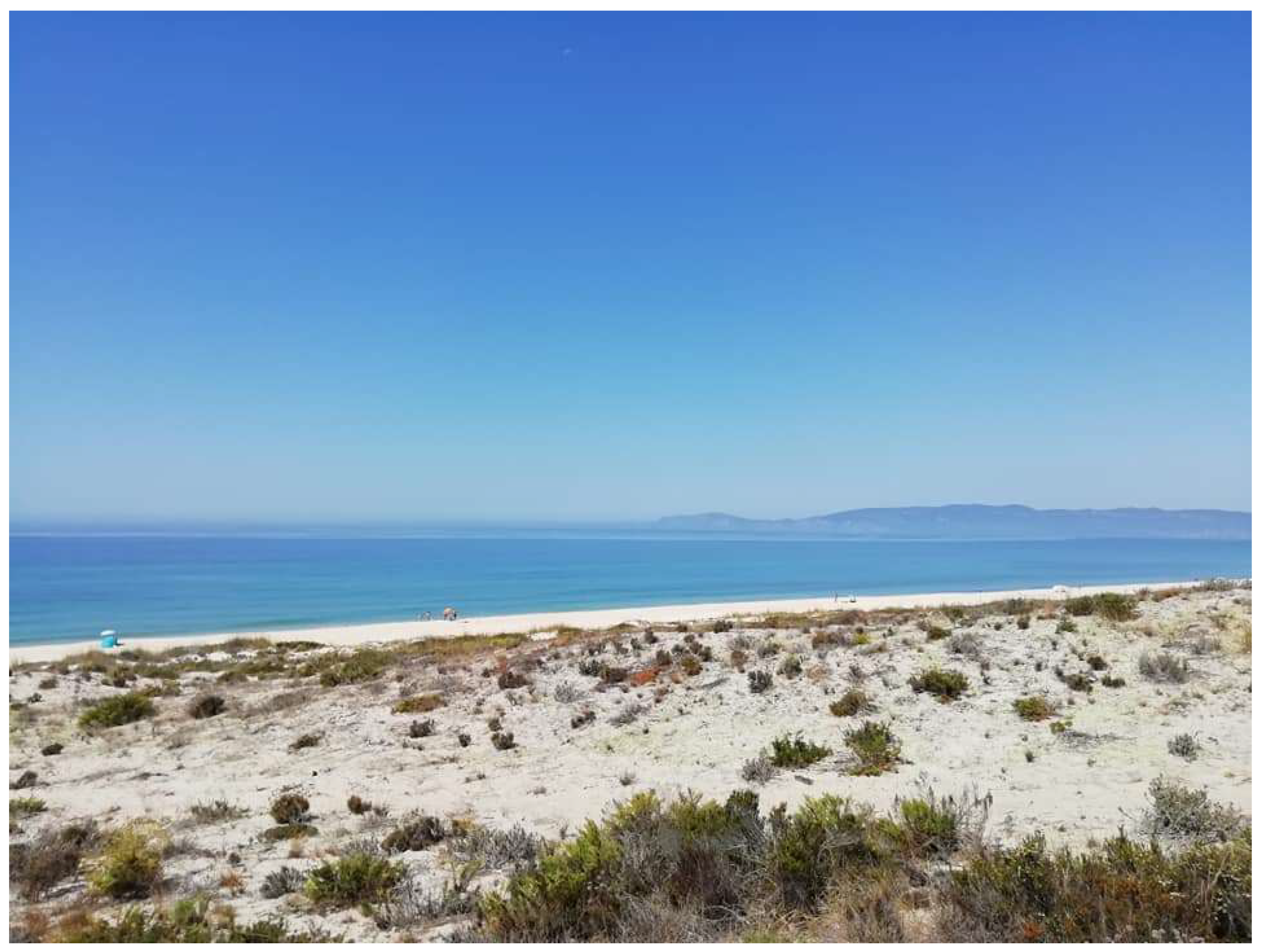
In 2018, the site was visited with the purpose of evaluating its real dimensions and preservation status. When the first survey was made, the idea of a shipwreck was immediately discarded. The location, number, distribution, and nature of the artefacts revealed that the site was more likely to have been a large domestic occupation. The site occupied an area approximately 300 m long by 100 m wide, at an elevation close to but not really on the beach, thus close to but not in the intertidal area (Figure 2).
When looking at the remains scattered on the surface, there was a high number of domestic ceramics, a large portion presenting wear marks as well as food remains. A first analysis of the found material culture suggested that the site had been occupied between roughly 1850 and 1920, with nothing suggesting a previous or later occupation. Even during that first survey, a coin minted in 1853, of XX réis, confirmed occupation in the second half of the 19th century.
A cartographic investigation revealed interesting data. Although a search was made on every known map regardless of date, where this area was represented, the first evidence of human occupation in that zone appeared in a map of the Setúbal harbor by M.C.A.V. Dumoulin, written in English and dating from 1852 (Figure 3).
In the area where the site was found, the map mentions the existence of “Fishermen’s Huts”, represented by three houses. The Plano Hidrográfico do Porto de Setúbal (1884) (Port of Setúbal Hydrographic Plan) represents the site in exactly the same place but now with the representation of fifteen houses named “Barracas da Costa” (Beach Huts). Three years later (1887), a new hydrographic plan signals beach huts at the same location, but this time without detailing how many. From then on, despite the several existing maps, none mentioned these huts again.
Although several other documentary sources were analyzed in search of evidence about this community, such as parish records, local newspapers, and property records, no other direct evidence mentioning them as fishermen was found. There may be several reasons for this. First, the lack of documentary evidence about this community is, if disappointing, not surprising. Although in the late 19th century a lot of information was produced about fishermen’s activities, based on the 1868 obligation of local governments to send the Ministério das Obras Públicas information about the river and sea fisheries of several parts of the country, this was usually only undertaken for large-scale communities and small settlements all around the country were ignored [21] (p. 153), even though fishermen paid taxes to the crown [18] (p. 117). As mentioned above, the second half of the 19th century was a period when fishing communities gained economic importance and were recognized as fundamental assets to the economy, especially in relation to the canned fish industry. The village was a small space in 1853. The first factory was implemented in Setúbal in 1854 [28] and the village grew immensely in the following years, so its growth may be directly related to that economic increase, although the inhabitants, as we will discuss, dedicated themselves to other activities such as agriculture.
Second, fishermen are not only fishermen, and bearing in mind the different activities developed by the community living in this village, we must consider that they may not have seen themselves as fishermen. A thorough analysis of the parish records for Montevil [29], the parish where this group of people was located, did not find any reference to the name of the beach where this settlement was located and they may thus have been baptized, married, and buried in Comporta, the closest church and cemetery. No reference to fishermen is made in the analyzed books (from 1858 to 1910). Instead, there are many references to jornaleiro, lavrador, and trabalhador rural (all agriculture-related activities). Considering the location of the settlement and the setting of Comporta, a place we know had direct contact with the Sado River and the long extension of beaches, it seems impossible that no fishermen lived in this area.
A few reasons can be considered for this absence. The first is seasonality. From the north to the south of Portugal, fishermen fished mostly in the summer months, which meant they dedicated a large part of the year to other activities, especially agriculture. This could be one of the reasons why, in the parish records, the chosen occupations are those that occupied the largest portion of the year.
A second hypothesis is related to the fact that it was somehow more prestigious to be considered an agricultural worker than a fisherman, and their sense of identity was not primarily that they belonged to that cultural group known as people working in sea activities. When reading documents about fishing communities in Portugal, they are always considered impoverished and uneducated (a prejudice that still has social weight nowadays), and the population may have identified themselves more directly with other activities. Although individuals may belong to multiple cultural groups and experience intersections of various identities, no evidence of that crossing was found.
Another hypothesis that seems very plausible is that this community was considered a fishing community not by themselves but by the people who surveyed the coast and drew those maps. Those surveys were always made during the summer months when the weather allowed for people to carry and use equipment to draw maps, precisely when fishing activities were more frequent. Also, the only map that actually mentions fishermen is the 1852 map, while the other two mention beach huts. This community may in fact have settled initially as a group of fishermen and then integrated into the economic and cultural lifestyle of combining fishing with agricultural work. This seems to be confirmed by a few early 20th-century photographs of this area (Tróia or Carrasqueira) showing similar settlement strategies; however, these communities are never mentioned as fishermen (Figure 4). What, then, made this settlement different to the point that a map refers to it as one of fishermen? Was it its location in the Costa da Galé, a place known for its fish resources [25]? This hypothesis is very interesting when considering landscape construction, especially because the landscape, as probably happens quite often, was not characterized by those who were building it, but by others who were looking at it and recording it.
Although not the major topic of this paper, this makes us think about how we as archaeologists and past-world builders may contribute to wrong landscape constructions. Tim Ingold defined the landscape as “the world as it is known to those who dwell therein, who inhabit its places and journey along the paths connecting them” [30] (p. 156); but those who dwell in them do not always share the same cultural perspectives, and while archaeologists can also dwell in the landscape, discovering and creating relations, they are necessarily the ones who build those landscapes while writing narratives about the past.
Excavation Results
In September 2019, a three-week excavation was carried out at the site. Its size did not permit excavation of a large portion of it, so it was decided to open three large diagnostic trenches. The choice of location for these was based on the surface evidence of the site. The first trench was opened in an area where a large portion of material culture was recovered at the surface; the second in a zone that was covered in solid vegetation and thus showed no sign of any disturbance; the third in the only area of the site where brick and mortar were identified (Figure 5). A descriptive report was published in Portuguese [31].
In Zone One, we identified a trash pit, where a large portion of material culture, food remains, metal instruments, and wood trunks were recovered. These objects, all consistent with the site dating, were recovered up to 60 cm deep. Their deposit was recorded in several small layers, which may indicate a progressive formation corresponding to what was interpreted as a trash pit receiving refuse for several decades. Here, not only household remains were found but also waste related to activities such as fishing (hooks, a small anchor, and remains of fish nets).
Zone Two was an undisturbed area where it was possible to identify at least one of the huts’ floors as represented in 19th-century cartography. Material culture, although in smaller amounts than in the trash pit, was found scattered during the excavation and a circular fireplace was discovered approximately 40 cm deep. This was composed of remains of charcoal and broken pots. No food remains were associated with this structure. It was possible to conclude that these were rectangular huts, architectonically similar to the type of architecture common in that part of the country during this period. The large number of iron nails recovered in this context indicated that we were excavating inside one of the huts. The floor of the cabin did not present any special treatment and was identified in part because it was somehow denser than the surrounding sand, but mostly because below this level there was no evidence of human occupation.
Zone Three was the only area where building material was identified and the surface revealed parts of bricks and mortar. When excavated, the remains of a very destroyed structure were found. Its shape was square, presenting a semicircular chamber inside. The construction made with bricks inside and consolidated with mortar on the outside, together with a large amount of ash and charcoal on the outside, suggests that this was an oven. The curious thing about this oven is that although most of the building materials used in it correspond to what has been used in contemporary buildings, some of its bricks and tiles present a much older typology, identified as Roman. As previously mentioned, the site is located just 8 km from a Roman site that in the 18th and 19th centuries was known as the quarry, from where people would extract stone and other usable materials [32].
Hundreds of artefacts were recovered during the archaeological excavation and typologically divided into ceramics, glass, metal, bone, and stone. The purpose of this paper is not to be an archaeological report (which was already published) and thus the singularity of these objects and their characteristics are not explored; however, they matter in the ways that they culturally frame the occupation of this site and enable inferences about the lifestyle, gender divisions, power relations, wealth, and how people dwelt in this settlement, permitting many different approaches not only relating to landscapes but also other theoretical perspectives, such as consumption or household archaeology (Figure 6) [33,34].
As expected, pottery was the most abundant find. Being a domestic environment, this type of object is fundamental to the comprehension of what type of activities were taking place here. What we considered to be tableware—the pottery used to serve food on the table such as plates and bowls—was the most recurrent, which is in accordance with what happened in other contexts dating from the same periods in Portugal [35,36]. Tableware was mostly produced in industrial units, and it is possible to recognize it as originating from the factories located in the Great Lisbon area, especially relating to the production of the Real Fábrica de Loiça de Sacavém. Two plates had production marks underneath, permitting us to date their production from the last years of the 19th century (1880–1902) [37]. Other productions are what is usually designated as northern pottery, a style created by the northern factories of Fervença, Bandeira ou Miragaia, although it was most likely produced in Lisbon factories [38].
Only one fragment of Chinese porcelain was recovered, possibly dating from the first half of the 19th century, although the consumption of porcelain for many decades after its production is a frequent consumer pattern in several parts of Europe and thus not an unexpected find [39]. As for English imports, they correspond to only a few fragments thus revealing a low number; this is in line with consumer behavior in other contexts, the willow pattern being the most frequent decoration [40].
Food preparation is associated with cookware and although a large number of frying pans were found, the foot of an iron-cast cauldron indicates that food was also prepared in metal cooking pots.
The remaining forms can be considered typical for this period. Large, flared bowls were used in food preparation, and water cups were used to individually drink water. As for water storage, although some costrels were identified, the elevated number of stoneware bottles may indicate that this was one of their uses, a habit identified in other areas of the country [41].
Glass is the second largest material culture category, although it corresponds exclusively to glasses and bottles. Bottles present the typical shape of dark green cylindrical vessels with tall necks, while cups have more variety in shape and color with transparent, blue, purple, and green glass [42].
Metals are essentially made of iron, except for three nails made with a copper alloy. Among the iron objects, of note is the elevated number of nails, fundamental in the construction of the type of house where this community lived, the sizes of which vary from 3 to 16 cm. Other iron objects include fish hooks, also with large variation in size from 5 to 12 cm long, used in what was one of the most frequent activities performed in this settlement. Less frequent objects include barrel or bucket arches, a hoe, a pick, and knives.
Smaller objects may not fit into either of the aforementioned categories; however, they are fundamental in debating the identity of the inhabitants of this settlement. Smoking pipes were a frequent discovery, all of which can be dated from the 19th century and all of which were imported from Britain. About two dozen small porcelain and bone buttons were recovered and are consistent with the site chronology. These are small, less than one centimeter in diameter with two perforations, and are usually recognized as being used in female clothing [43]. It is interesting that both bone and porcelain buttons are found at this site since these are usually associated with different levels of wealth, something usually not recognized in much smaller settlements. A bone hairpin was also found and could be associated with female occupants. A small ceramic doll head, which seems to have fitted into a cloth body, may indicate the existence of children (Figure 7).
The items found on this site reveal the amphibious character we have discussed so far. The fish hook and the hoe are the most straightforward examples, used to explore the sea and the land, because these are in themselves a reflection of this specific identity. This can be seen not only in the tools used for sea and land or in the food remains, but also in how objects were used in the maintenance of a style of life that combined the two worlds where the community thrived.
3. Historical Amphibious Landscapes
It is never easy to reconstruct a late 19th-century historical landscape and it becomes even more difficult when so many debates about identity must be considered. For the purpose of this village or community, we have to consider facts, and illations derived from those facts, that permit the reconstruction of a tangible and intangible landscape.
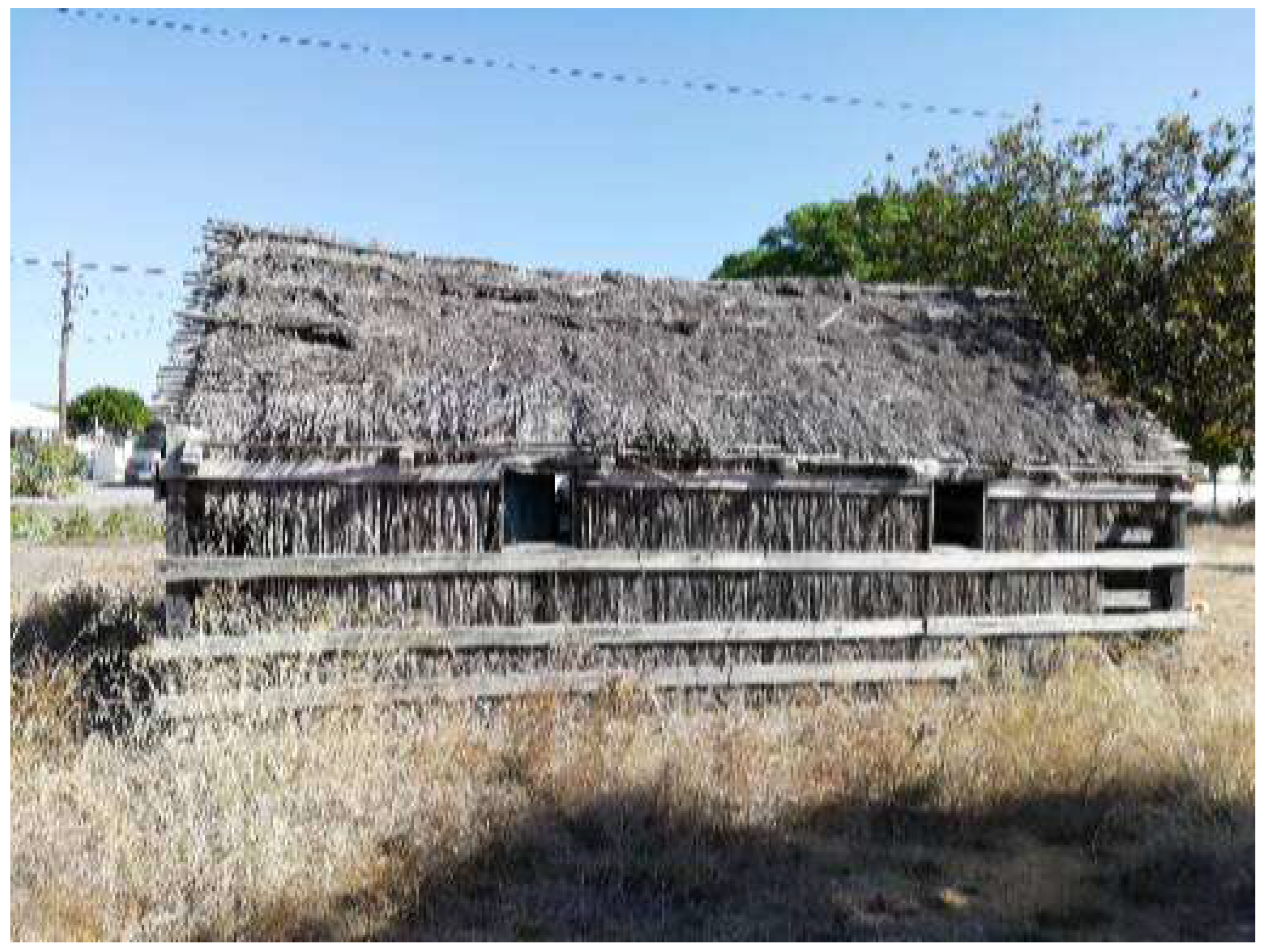
In terms of physical landscape, we can assume that we are dealing with a group of around a dozen sheds built with traditional techniques, similar to the houses that were built in that zone for centuries. These correspond to long rectangular houses framed with wood and iron nails, their walls made of straw and mud, and a thatched roof. This type of vernacular architecture seems to have been used since at least the Middle Ages and was in regular use until the 20th century. These varied in size and were adapted to the number of people living inside [44,45,46] (Figure 8).
These traditional housing techniques, where a fireplace was located at the center of the floor and life occurred around it, were combined with the use of industrialized artefacts, especially those used in daily household occupations such as cooking, eating, and drinking. This combination of traditional dwelling techniques, the use of bricks from 2000 years prior, with innovative ways of consumption, created what we could call a multitemporal site [47], which translates into a multitemporal landscape. This is usually assumed when very traditional and long-lasting behaviors are combined with innovative performances demonstrating that communities are complex and different technologies are combined, signifying that this village was in itself a place where innovation and tradition were both modeling the way people lived.
A combination of archaeological evidence and documentary information reveals that the community comprised men, women, children, and the elderly. We can say for a fact that women wore buttoned-up chemises and children walked around with dolls while most men smoked pipes. Although we are aware that women also smoked, there was a general idea in Portugal that smoking was a man’s activity and only they are depicted doing it. There are even texts concerning the bad behavior of women smoking, and so we can at least say that most pipes found on the site would probably have been used by men [48]. We can also say, based on the archaeological finds, that the community ate fish as well as goat, chicken, pig, and sheep, and that cats and dogs were around while seagulls crossed the skies, a clear indication that different resources, both in sea and on land, were exploited. Close to the fireplace, there was evidence of small artefact carving. Anyone with a pocket knife could have done it while waiting for time to pass.
Some photographs of the area taken in the 1920s (when the village was being abandoned) show that there were probably small gardens where some vegetables would grow; thus, both fishing and farming influenced the way people interacted with the world around them, exploiting the natural resources available (Figure 4).
This small but accurate reconstitution is, however, far from everything we can add, and while the above description was possible to virtually reconstruct, there is so much more that can be said while reconstructing a behavioral and identity-oriented landscape (Figure 9).
Taking this into consideration, it should be important to ask whether in fact this community actually felt like a fishing community in the way they are recognized in the 1852 map. Although they were located by the sea and explored both sea and river, they were also an inland community, demonstrating what we call amphibious behavior. Fishermen, contrary to farmers or rural workers, have to deal with variable and sometimes unreliable resources. One can kill a goat, and only a catastrophic event will destroy an entire crop, but the sea or the river is unpredictable, and it can be out of reach for weeks. Moreover, while the land has quite strict divisions and property, the sea, despite the payment of taxes for its use, is explored in a borderless way [49] (p. 111). A mobile and volatile resource creates a different social and cultural pattern from more stable agricultural exploitation. But both were happening at this site, and this is why calling it a maritime cultural landscape feels inadequate to characterize all the different ontological relations happening within the group.
It is so much more than a landscape. It is also a seascape, or a maritime (cultural) landscape; it is all of them at the same time, creating a hybrid scape between the land and the sea. It is also a taskscape [30], considering the interwoven exploration of the natural and built environment and the way people existed in this space, continuously shaping and transforming it, in a permanent stage of becoming. People worked, lived, ate, loved, cried, died, and slept in this place, among many other activities, performing voluntary and involuntary actions that modeled the landscape, adding something new every day.
4. Conclusions
Although the excavation of the site was quite small (it corresponds to approximately 100 m2, in a site we believe may reach an area of more or less 30,000 m2), when associated with ethnographic and historical research of the communities living in that area, it seems possible to reconstruct this historical amphibious landscape, discussing concepts such as identity, gender, wealth, and exploitation of natural and cultural resources.
The settlement seems to have been built somewhere in the mid 19th century. Not only is this date confirmed by the maps where the settlement is depicted, but there is also nothing in the archaeological excavation that suggests otherwise. Considering the maps, the site grew exponentially and in 30 years increased from 3 to 15 huts. This is consistent with the size of the archaeological site defined in 2019. This increase in size seems to have translated into an increase in the number of residents and necessarily in the number of objects consumed, especially those related to food and water consumption.
The analysis of material culture elements, in association with the parish records, also enabled interesting discussions about the social composition of that society, with men, women, children, and the elderly sharing the same space. This is what one would expect of a community settled for a few generations, where domestic habits would create models of social reproductivity. Whether fishing or farming, the family was a fundamental structure in the lives of these people. Parish records support this, since while men are presented as jornaleiros, lavradores, or trabalhadores agrícolas, women are, with four exceptions where they are cited as mendigas (beggars) and lavradoras (agricultural workers), are always cited as workers in the domestic activities of their own houses. This does not mean that they did not engage in activities related to fishing and working the land. They most probably did; they repaired fishing nets and sold the fish and worked the land, as is documented in many photographs [50,51]. This landscape was an amphibious reality, a combination or symbiosis of land and sea, where a multiplicity of lives took place. As Ingold described so well: “life is not just one story but a host of different stories, (…) but these multiple stories can run alongside one another” [52] (p. 142). This community was certainly involved in sea activities, but also in others, like agriculture and animal husbandry of small cattle such as chickens, goats, pigs, and sheep. The material culture found on the site supports this amphibious lifestyle with nourishment obtained from sea and land, and artefacts that were used to fish and work the land. Different agents were making all these stories happen at the same time and in the same space, creating a community. It is not possible to infer for certain what their main economic activity was; however, the material evidence found on the site does not suggest that they identify with what was typically considered a fisherman’s way of life, described by many contemporary authors (such as Raul Brandão) and in many different chronologies as an extremely poor population, always depending on what the unpredictability of the sea could offer. The material culture found on the site corresponds to what was found in several urban sites excavated in other areas of the country, including nearby Setúbal, revealing the acquisition capacity of people who, not being rich, were not considered poor [53,54]. This village is a contradiction when we think about the fishing communities represented in literary descriptions or in paintings and photographs from the late 19th or early 20th century.
However, despite all the questions and issues raised in this paper, there is still one question that we cannot provide an answer to: Why did a community that had grown so much over a generation, with access to food and water and the ability to acquire the necessary commodities, abandon that space? Many reasons can be pointed out, but there is no evidence that the abandonment was abrupt. This population took its time leaving and they only left behind broken things or things that had no value.
As previously mentioned, the canned fish industry in Setúbal was formed roughly around the time this village started to thrive, and the increase in the demand for fish may have promoted their economic growth, which was shared with agricultural work. Its abandonment may have been related to fishing problems. During the First World War, Portuguese waters were not safe, and fishing was a dangerous activity, with many small ships being destroyed [55]. Or could these problems have started even earlier? In the Diário Popular newspaper dated 26 August 1894, news was published that for over six months in Setúbal over a large portion of Portuguese coastal waters, there was a lack of fish, especially sardines. Just over a year later, on 21 December 1895, the newspaper O Século published that the fishnets left the sea as light as they entered. Could this lack of fish have been the beginning of the end for this village? If fishing was not profitable anymore and they had to work the land all year long, could they have moved closer to the crop areas? Even if not that far, when working inland, they would have had to walk or ride a horse for at least 3 km to reach the closest working area. Recollecting what Raul Brandão wrote about the fishermen, that “if the sea gets sick, they get sick” [1] (p. 50), it seems that this may have happened here for the community that lived between the sea and the land, and they gave up on their amphibious lifestyle.
Whatever the reasons for the abandonment, roughly 100 years after that event, the purpose of this paper is to discuss how this site enabled the generation of a multiplicity of scapes. In this paper, the community and the people who lived on this site are called an amphibious or hybrid scape where sea, beach, river, and rural areas are mingled in the creation of an identity shared by a community who are as much fishermen as they are rural workers, living between worlds.
Funding
This research received no external funding.
Data Availability Statement
Not applicable.
Acknowledgments
Several people were involved in this project. My warm thanks go to Afonso Leão, Beatriz Reis, Maria Rosa, José Proença, Inês Costa, Mafalda Claro, Guilherme Mateus, Pedro Chaves, Inês Madeira, Marco Santos, Mariana Chaves, Flávio Biscaia, Alexandre Monteiro, Miguel Martins, Paulo Costa, John Sexton, Filipe Castro, Patrícia Brum, Patrícia Magalhães and Inês Vaz Pinto, Isabel Revez, Purificação Pereira, and Idálio Nunes. To João Sequeira and Joel Santos for the amazing discussions. To John Sexton for being part of the excavation team. The support of Freguesia do Carvalhal was fundamental. Figure 4 was kindly made accessible by the Municipality of Alcáecer do Sal through Marisol Ferreira. This project started as part of the Mergulho da História project but, due to unplanned circumstances, followed its own course. Thank you to all the people who helped to conceptualize this discussion, especially to Flávio Biscaia, without whom I would have never found out about this site. Tânia Casimiro is funded by the FCT project (DL57/2016/CP1453/CT0084).
Conflicts of Interest
The author declares no conflict of interest.
References
- Brandão, R. Os Pescadores; Neolivros: Lisbon, Portugal, 2018. [Google Scholar]
- Pauwelussen, A.P. Amphibious Anthropology: Engaging with Maritime Worlds in Indonesia. Ph.D. Thesis, Wageningen University, Wageningen, The Netherland, 2017, unpublished. [Google Scholar]
- Tilley, C. A Phenomenology of Landscape: Places, Paths and Monuments; Berg: Oxford, UK, 1994. [Google Scholar]
- Bender, B. Introduction. In Contested Landscapes; Bender, B., Winer, M., Eds.; Berg: Oxford, UK, 2001; pp. 1–20. [Google Scholar]
- Westerdahl, C. Maritime Cultural Landscapes. Int. J. Naut. Archaeol. 1992, 21, 5–14. [Google Scholar] [CrossRef]
- Westerdahl, C. The Maritime Cultural Landscape on the Concept of the Traditional Zones of Transport Geography. 1998. Available online: http://www.abc.se/~pa/publ/cult-land.htm (accessed on 16 September 2023).
- Muckelroy, K. Maritime Archaeology; Cambridge University Press: Cambridge, UK, 1978. [Google Scholar]
- Ford, B. Lake Ontario Maritime Cultural Landscape. Ph.D. Thesis, Texas A&M University, College Station, TX, USA, 2009. [Google Scholar]
- Ford, B. (Ed.) The Archaeology of Maritime Landscapes; When the Land Meets the Sea Series; Springer: New York, NY, USA, 2011. [Google Scholar]
- Popta Yftinus, T.; Westerdahl Christer, L.; Duncan Brad, G. Maritime Culture in The Netherlands: Accessing the late medieval maritime cultural landscapes of the northeastern Zuiderzee. Int. J. Naut. Archaeol. 2018, 48, 172–188. [Google Scholar] [CrossRef]
- Vladimirova, M. Maritime Cultural Landscape—Cultural Tourism—Sustainable Development. Int. J. Cult. Digit. Tour. 2016, 3, 56–65. [Google Scholar]
- Carvalho, P.; Bettencourt, J.; Coelho, I. The maritime cultural landscape of the Ria de Aveiro lagoon (Portugal) in the Early Modern period in Negueruela. In Actas del V Congreso Internacional de Arqueología Subacuática (IKUWA V); Martinez, I., Castillo Belinchón, R., Recio Sanchéz, P., Eds.; Ministerio de Educacion Cultura Y Deporte, Secretaria General Técnica: Madrid, Spain, 2016; pp. 368–378. [Google Scholar]
- Mataix Ferrándiz, E. Shipwrecks, Legal Landscapes and Mediterranean Paradigms; Brill: Leiden, The Netherland, 2022. [Google Scholar]
- Blue, L.; Al-Jahwari, N.; Staples, E.; Giorgio, L.; Croce, P.; Ghidoni, A.; Nagmoush al Busaidi, A.; Belfioretti, L. Proceedings of the Seminar for Arabian Studies; Archaeopress: Oxford, UK, 2014; Volume 22, pp. 53–68. [Google Scholar]
- Parker, A. A maritime cultural landscape: The port of Bristol in the Middle Ages. Int. J. Naut. Archaeol. 1999, 28, 323–342. [Google Scholar]
- Dème, A. Maritime Cultural Landscape, Social Organization, and Shell Midden Archaeology in Senegambia. Antrope 2021, 13, 65–81. [Google Scholar]
- Freire, J.V. Maritime Cultural Landscape: A New Approach to the Cascais Coastline. J. Marit. Archaeol. 2014, 9, 143–157. [Google Scholar] [CrossRef]
- Amorim, I. Formas de organização do trabalho da pesca em finais do séc. XIX, na Póvoa de Varzim. In Estudos em Homenagem ao Professor João Francisco Marques; Ramos, L., Ribeiro, J., Polónia, A., Eds.; Universidade do Porto—Faculdade de Letras: Porto, Portugal, 2001; pp. 113–134. [Google Scholar]
- Direcção Geral do Commercio e Indústria. Inquérito Industrial de 1890; Imprensa Nacional: Lisbon, Portugal, 1891. [Google Scholar]
- Cahyono, N. The creative behaviour of Fishermen Communities in Kedungrjo village, Muncar, Banyuwangi. Int. J. Res. Humanit. Soc. Stud. 2019, 6, 46–52. [Google Scholar]
- Alves, J.A. Pesca e os Pescadores do Litoral Portuense em 1868. In Revista da Faculdade de Letras; II Série; Universidade do Porto, Faculdade de Letras: Porto, Portugal, 1991; Volume VIII, pp. 151–184. [Google Scholar]
- Barkhalm, S. The Basque Whaling Establishments in Labrador 1536–1632—A summary. Artic 1984, 37, 515–519. [Google Scholar]
- Sicking, L.; Abreu-Ferreira, D. (Eds.) Beyond the Catch Fisheries of the North Atlantic, the North Sea and the Baltic, 900–1850; Brill: Leiden, The Netherland, 2009. [Google Scholar]
- Pieters, M.; Verhaeghe, F.; Gevaert, G.; Mees, J.; Seys, J. (Eds.) Colloquium Fishery, Trade and Piracy: Fishermen and Fishermen’s Settlements in and around the North Sea Area in the Middle Ages and Later, 21–23 November 2003 Museum Walraversijde, Oostende, Belgium; Flanders Marine Institute (VLIZ)/Free University of Brussels, Department of Art History and Archaeology/Province of West Flanders: Oostende, Belgium, 2003. [Google Scholar]
- Silva, A. Estado Actual Das Pescas Em Portugal, Comprehendendo a Pesca Marítima, Fluvial e Lacustre em Todo o Continente do Reino, Referido No Anno de 1886; Imprensa Nacional: Lisbon, Portugal, 1891. [Google Scholar]
- Ferreira, D.; Simões, M.; Reboredo, F.; Pessoa, F.; Almeida, A.; Daradzhanska, I.; Lidon, F. Alterações climáticas nas Bacias do Sado e Tejo e seus efeitos na produtividade de arroz. In VII Congresso Nacional de Rega e Drenagem, Monte Real; COTR-Centro Operativo e de Tecnologia de Regadio: Beja, Portugal, 2018; pp. 1–9. [Google Scholar]
- Lopes, M.J.; Neto, J.L.; Seromenho, L. Sobre uma possível embarcação descoberta na comporta. In Subsídios Para o Estudo da História Local 3; Câmara Municipal de Setúbal: Setúbal, Portugal, 2006; pp. 175–181. [Google Scholar]
- Alcântara, A. A indústria conserveira e a evolução urbana de Setúbal (1854–1914). Musa Mus. Arqueol. E Outros Patrimónios 2010, 3, 237–246. [Google Scholar]
- Arquivos Paroquiais Paróquia de Montevil, Arquivo Distrital de Setúbal: Setúbal, Portugal; Ref PT/ADSTB/PRQ/PASL12. Available online: https://digitarq.adstb.arquivos.pt/details?id=1206938 (accessed on 1 August 2023).
- Ingold, T. The Temporality of the Landscape. World Archaeol. 1993, 25, 152–174. [Google Scholar] [CrossRef]
- Casimiro, T.M.; Biscaia, F.; Martins, A.M.; Monteiro, A. Comunidade e identidade marítima. Uma aldeia de pescadores na Península de Tróia nos finais do século XIX. In Arqueologia Contemporânea em Portugal (Séculos XIX e XX); Casimiro, T.M., Sequeira, J.L., Eds.; Mazu Press: Lisbon, Portugal, 2020; pp. 49–64. [Google Scholar]
- Pinto, I.V.; Magalhães, A.P.; Brum, P. Ruínas Romanas de Tróia: A valorização de um património singular. Musa Mus. Arqueol. E Outros Patrimónios 2014, 4, 29–40. [Google Scholar]
- King, J. Household archaeology, identities and biographies. In Cambridge Companion to Historical Archaeology; Hicks, D., Beaudry, M., Eds.; Cambridge University Press: Cambridge, UK, 2006; pp. 293–313. [Google Scholar]
- Mullins, P. The Archaeology of Consumer Culture; University Press of Florida: Gainesville, FL, USA, 2011. [Google Scholar]
- Araújo, J.; Oliveira, N. Uma (pequena) janela, aberta pela Arqueologia, sobre o quotidiano Urbano micaelense de final de oitocentos (São Miguel, Açores). In Arqueologia Contemporânea em Portugal (Séculos XIX e XX); Casimiro, T.M., Sequeira, J.L., Eds.; Mazu Press: Lisbon, Portugal, 2020; pp. 91–122. [Google Scholar]
- Capote, M.; Sequeira, J.L.; Barros, L.; Casimiro, T.M. Uma lixeira contemporânea na Quinta do Almaraz em Almada (1890–1910) e a importância da gestão dos lixos urbanos. In Arqueologia Contemporânea em Portugal (Séculos XIX e XX); Casimiro, T.M., Sequeira, J.L., Eds.; Mazu Press: Lisbon, Portugal, 2020; pp. 49–64. [Google Scholar]
- Fábrica de Louça de Savavém. Para Uma História da Faiança em Portugal; Câmara Municipal de Loures: Loures, Portugal, 2016. [Google Scholar]
- Assunção, A. A Fábrica de Louça de Sacavém; INAPA: Lisbon, Portugal, 1997. [Google Scholar]
- Linna, J. Memorable, Modern or Mundane? Investigating the Place of Porcelain and Majolica in Homes and Hearts in Early Modern Denmark. In Material Exchanges in Medieval and Early Modern Europe. Archaeological Perspectives; Naum, M., Linna, J., Escribano-Ruiz, S., Eds.; Brepols: Turnhout, Belgian, 2021; pp. 73–112. [Google Scholar]
- Casimiro, T.M.; Castro, I.; Silva, T. Cerâmica estampada britânica em Portugal (1780–1920). Identidade, domesticidade e relações. Ophiussa 2021, 5, 207–217. [Google Scholar] [CrossRef]
- Leão, A.; Sousa, R.; Martingil, M.; Filipe, V. Fancy a drink? As garrafas da Rua do Salitre e o consumo de água e gin em lisboa no século XIX. In Arqueologia Contemporânea em Portugal (Séculos XIX e XX); Casimiro, T.M., Sequeira, J.L., Eds.; Mazu Press: Lisbon, Portugal, 2020; pp. 65–90. [Google Scholar]
- Coutinho, I.; Medici, T.; Alves, L.C.; Gratuze, B.; Vilarigues, M. Provenance studies of 18th century potassium-rich archaeological glass from Portugal. J. Archaeol. Sci. Rep. 2017, 13, 185–198. [Google Scholar] [CrossRef]
- Marcel, S. Buttoning down the Past: A Look at Buttons as Indicators of Chronology and Material Culture. Ph.D. Thesis, University of Tennesse, Knoxville, TN, USA, 1994, unpublished. [Google Scholar]
- Bruno, P.; Faria, P. Cabanas de Materiais Vegetais na Herdade da Comporta—Tradição Construtiva e Novas Abordagens; Argumentum: Lisbon, Portugal, 2010. [Google Scholar]
- Oliveira, E.; Galhano, F.; Pereira, B. Construções Primitivas em Portugal, 2nd ed.; Publicações Dom Quixote: Lisbon, Portugal, 1988. [Google Scholar]
- Pires, M. Arquitectura Das Cabanas Do Estuário Do Sado—Formas E Vivências Dos Espaços Vernaculares. Master’s Thesis, Universidade Técnica de Lisboa, Lisbon, Portugal, 2014, unpublished. [Google Scholar]
- González-Ruibal, A. Archaeology and the time of modernity. Hist. Archaeol. 2016, 50, 144–164. [Google Scholar] [CrossRef]
- Ribeiro, M. Mulheres Fumadoras. In Trabalhos de Antropologia e Etnologia, XXI; Portugal, 1969; pp. 231–242. [Google Scholar]
- Amorim, I. The Evolution of Portuguese Fisheries in the Medieval and Early Modern Period. A. Fiscal Approach. In Beyond the Catch Fisheries of the North Atlantic, the North Sea and the Baltic, 900–1850; Sicking, L., Abreu-Ferreira, D., Eds.; Brill: Leiden, The Netherland, 2009; pp. 245–282. [Google Scholar]
- Amorim, I. Mulheres no sector das pescas na viragem do século XIX, formas de participação na organização do trabalho. Arquipél. Hist. 2005, 9, 661–683. [Google Scholar]
- Pacheco, S. Why do we need gender archaeology when studying factories? In Trabalho (no) Feminino—Histórias de Mulheres (Séculos XVIII a XX); Silva, S., Moscatel, C., Oliveira, N., Soares, D., Valério, B., Eds.; Letras Lavasa Edições: São Miguel, Portugal, 2023; pp. 186–205. [Google Scholar]
- Ingold, T. Being Alive: Essays on Movement, Knowledge and Description; Routledge: London, UK, 2011. [Google Scholar]
- Reis, A.; Roque, J.; Filipe, V.; Henriques, J.; Casimiro, T.M. A voz dos esquecidos. Evidências materiais de pobreza na cidade de Lisboa nos inícios do século XX. In Arqueologia Contemporânea em Portugal (Séculos XIX e XX); Casimiro, T.M., Sequeira, J.L., Eds.; Mazu Press: Lisbon, Portugal, 2020; pp. 143–156. [Google Scholar]
- Graça, A. O Quotidiano nos séculos XIX e XX: A Casa Eloy na dinâmica habitacional de Setúbal. Almadan 2022, 25, 70–76. [Google Scholar]
- Brandão, M. A crise do abastecimento português (1914-1918)—Os impactos sociais e económicos da guerra submarina alemã. CEM 2021, 13, 191–213. [Google Scholar] [CrossRef]
Figure 1.
Location of the site.

Figure 2.
Location of the site (photo by T. M Casimiro).

Figure 3.
Map of the Setúbal harbor by M.C.A.V. Dumoulin (1852).

Figure 4.
Small settlement of huts in Alcácer do Sal (courtesy Município de Alcácer do Sal).

Figure 5.
Aerial photo of the site with some of the excavated areas (photo by Flávio Biscaia).

Figure 6.
Selection of materials found on the site (drawings and photos T. M. Casimiro).

Figure 7.
Selection of objects found on site.

Figure 8.
Traditional hut (photo by T. M. Casimiro).

Figure 9.
Virtual reconstruction of the village (courtesy Miguel Martins).

Disclaimer/Publisher’s Note: The statements, opinions and data contained in all publications are solely those of the individual author(s) and contributor(s) and not of MDPI and/or the editor(s). MDPI and/or the editor(s) disclaim responsibility for any injury to people or property resulting from any ideas, methods, instructions or products referred to in the content. |
© 2023 by the author. Licensee MDPI, Basel, Switzerland. This article is an open access article distributed under the terms and conditions of the Creative Commons Attribution (CC BY) license (https://creativecommons.org/licenses/by/4.0/).
Share and Cite
MDPI and ACS Style
Casimiro, T.M. Living by the Sea: Amphibious Landscapes of Identity and Community in a 19th-Century “Fisher’s” Village (Grândola, Portugal). Heritage 2023, 6, 6510-6525. https://doi.org/10.3390/heritage6100340
AMA Style
Casimiro TM. Living by the Sea: Amphibious Landscapes of Identity and Community in a 19th-Century “Fisher’s” Village (Grândola, Portugal). Heritage. 2023; 6(10):6510-6525. https://doi.org/10.3390/heritage6100340
Chicago/Turabian StyleCasimiro, Tânia M. 2023. "Living by the Sea: Amphibious Landscapes of Identity and Community in a 19th-Century “Fisher’s” Village (Grândola, Portugal)" Heritage 6, no. 10: 6510-6525. https://doi.org/10.3390/heritage6100340