Skip to Content
You are currently on the new version of our website. Access the old version .
  • Tracked for
    Impact Factor
  • 4.0
    CiteScore
  • 23 days
    Time to First Decision

Mining

Mining is an international, peer-reviewed, open access journal on mining science and engineering published quarterly online by MDPI.

All Articles (272)

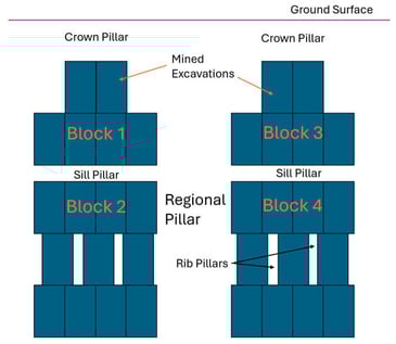
Hydraulic fracturing is a widely used technique in the oil and gas industry and, specifically, it is used in mining for fragmentation enhancement and rockburst risk mitigation. The technique is actively being applied to cave mining environments to induce caving and improve seismic response in deep high-strength rock masses. The method has great potential in Long Hole Open Stoping mines for large-scale stress management in high-risk environments. The use of hydraulic fracturing in deep mining was explored through the development of a conceptual design for the destressing of a mining pillar. Numerical modeling was conducted to understand the effects hydraulic fracture has on stress reduction, and how fractured geometries affect these results. The results of this analysis showed that there is a strong dependence on the geometry of hydraulic fractures on the stress reduction potential of the method. The developed conceptual design showed that hydraulic fracturing can be directly integrated into mine planning as a tool to strategically manage the hazards associated with highly stress pillars. The activities associated with treatment design directly identifies when treatment should occur in the mining sequence and provides a general assessment of risk reduction that can be used directly for operational decision-making.

18 February 2026

Vertical cross-section of mining pillar types, excavations are in blue, intact rock is uncolored.

Close-distance multi-seam mining frequently induces secondary surface deformation and subsidence. Extracting a lower coal seam beneath an existing goaf repeatedly disturbs the overburden, often leading to roof collapse and the expansion of vertical water-conducting fractures that connect the working face to aquifers. Furthermore, the overlying goaf increases the risk of water inrush into active lower workings. This study investigates the mechanisms of strata reactivation and fracturing within an overlying goaf during lower seam extraction at a mine in Northwest China. Using theoretical analysis, numerical simulation, and microseismic monitoring, the research examines the secondary fracture mechanisms of the goaf roof and the resulting water-inrush potential. Research Findings: Strata Instability: Analysis of the key sandstone strata indicates that subsidence (W) of the key rock blocks satisfies 3.17 < W1 = 4.61 m < 18 m for the lower seam and 3.17 m < W2 = 5.31 m < 69.6 m for the 3-1# seam. These values confirm that key rock blocks in the basic roof undergo “reactivated” instability following fracture during lower seam mining. Pressure Relief and Fluid Dynamics: Mining-induced fracture initiation and propagation trigger strata reactivation. As the distance to the center of the goaf decreases, the subsidence of the overburden increases, ultimately resulting in a “trapezoidal” bending deformation pattern. Due to secondary activation, the roof subsidence 30 m above the 221 coal seam increased from 1.89 m to 5.475 m. The layers of high-strength, medium-grained sandstone and siltstone overlying the 317 coal seam and beneath the 221 goaf serve as high-strength material for the overlying rock formations. This suppresses the development of the caving zone and fracture zone, leading to subsidence failing to reach the sum of the heights of the two coal seams (6.8 m) and only reaching a value of 5.475 m. During extraction, the stress field undergoes a distinct evolution: it transitions from an initial “regular triangular” pressure-relief zone into a tripartite “weak–strong–strong” distribution. Furthermore, fluid discharge in the overlapping zone between the 317 working face and the 221 goaf increased sequentially, displaying an “alternating” pattern of peak vector variations as the face advanced. Microseismic Activity: Monitoring within the 300–500 m range identified frequent low-energy events and high-magnitude events (104 J, 105 J). These findings demonstrate that secondary excavation directly impacts the aquifer, creating a significant water-inrush hazard for the active working face.

17 February 2026

Geographical location map.

The study presents the development of a backfill composite based on technogenic waste with controlled volumetric stability, ensuring complete filling of underground voids while maintaining high strength performance. The formulation incorporates beneficiation and metallurgical wastes, as well as activators, foaming agents, and reinforcing fibers. A comprehensive analysis of strength, pore structure, and fracturing was performed using CT-scanning, 3D reconstruction, and fractal analysis. It was established that fibers of different nature exert multidirectional effects on porosity and strength, with basalt fiber contributing to the formation of a hierarchically stable structure. The results obtained confirm the feasibility of producing an environmentally efficient backfill material for safe mineral resource extraction.

11 February 2026

Internal structure analysis using CT scanning: (a) laboratory setup; (b) scanning sequence and principle of operation (the scanning direction is indicated by arrows).

The rupture of the B-I dam at the Córrego do Feijão mine in Brumadinho, Minas Gerais, Brazil, on 25 January 2019, prompted the implementation of environmental remediation actions. Among these actions is the need for groundwater quality monitoring in the Feijão Pit (“Cava de Feijão”) area due to the disposal of tailings from dams B-I, B-IV, and B-IVA at this site. In order to assess potential impacts on groundwater, the determination of baseline values for elements of interest was proposed for ten monitoring wells installed in and around the pit, with monitoring results from 2019 to 2024, totaling 854 samples. Due to the lack of hydrochemistry data and local hydrogeological complexity of the existing aquifers within the context of the Iron Quadrangle (IQ), it was necessary to evaluate and determine individual baseline values for each monitoring well, assessing data variability and population distribution. For this purpose, the 95–95 Upper Tolerance Limit (UTL) method was applied to establish baseline values providing a robust statistical approach that encompasses 95% of observations with a 95% confidence interval as it is a widely used standard in statistics due to its practical balance between confidence and precision. This methodology proved effective and has potential for application in groundwater monitoring in areas that may present high compositional variability due to the chemical heterogeneity of the groundwater. The baseline values obtained for the main elements of interest, which are iron (Fe) and manganese (Mn), were consistent with findings from previous studies conducted in the hydrogeological units of the study area, also demonstrating that the adopted methodology was effective in identifying representative concentrations for the region.

7 February 2026

(a) Location of the state of Minas Gerais; (b) location of the Iron Quadrangle (IQ) in the south-central region of Minas Gerais; (c) general geology of the IQ. Modified from [19].

News & Conferences

Issues

Open for Submission

Editor's Choice

Reprints of Collections

Mining Innovation
Reprint

Mining Innovation

Editors: Krzysztof Skrzypkowski, René Gómez, Fhatuwani Sengani, Derek B. Apel, Faham Tahmasebinia, Jianhang Chen
Envisioning the Future of Mining
Reprint

Envisioning the Future of Mining

Editors: Juan M Menéndez-Aguado, Oscar Jaime Restrepo Baena, Jessica M. Smith

Get Alerted

Add your email address to receive forthcoming issues of this journal.

XFacebookLinkedIn
Mining - ISSN 2673-6489