Article

Use of Human Dominated Landscape as Connectivity Corridors among Fragmented Habitats for Wild Asian Elephants (Elephas maximus) in the Eastern Part of Thailand

by
Rattanawat Chaiyarat
1,*,
Maneepailin Wettasin
2,
Namphung Youngpoy
1 and
Navee Cheachean
1
1
Wildlife and Plant Research Center, Faculty of Environment and Resource Studies, Mahidol University, Nakhon Pathom 73170, Thailand
2
Environmental Management and Technology, Faculty of Environment and Resource Studies, Mahidol University, Nakhon Pathom 73170, Thailand
*
Author to whom correspondence should be addressed.
Diversity 2023, 15(1), 6; https://doi.org/10.3390/d15010006
Submission received: 25 October 2022 / Revised: 12 December 2022 / Accepted: 17 December 2022 / Published: 21 December 2022

Abstract

:
Habitat fragmentation due to human activities creates threats to wild Asian elephants (Elephas maximus) and increases human-elephant conflicts (HEC). This study analyzed connectivity maps among the core habitats of wild elephants in the eastern part of Thailand. Resistance surfaces, associated with geographic and land use features, were used to estimate the dispersal of wild elephants. An increase in roads, reservoirs, and agricultural areas in 2020 was noted. In addition, the increase of artificial water sources and roads has increased HEC. To reduce HEC, the study of suitable landscape corridors for wild Asian elephants can guide the development of effective connectivity among the habitat patches. The scattered locations of reserved forests induce wild elephants to enter agricultural areas. In 2020, during the dry season, wild elephants used 3552 habitat patches, 253 population patches (4875 km2), 8 breeding patches (68.1 km2), and 253 other patches (193.9 km2). However, habitat patches were reduced to 1961 patches (3850.9 km2) in the wet season. The 16 suitable corridors were recommended for connecting the finest wild Asian elephants. These suitable corridors can be used as a guideline to construct effective landscape corridors for wild Asian elephants’ movement among the habitat patches. This finding can help the local managers and villagers incorporate and design restoration areas for the movement and survival of wild Asian elephants and develop suitable areas for agricultural purposes.

1. Introduction

Large mammals, such as the wild Asian elephant (Elephas maximus), require a variety of ecosystems spread over large areas [1,2,3]. Habitat fragmentation caused by human activities can result in increased threats to wild elephant populations [4,5] and hence, in human-elephant conflicts [6]. HEC causes a variety of negative impacts on both humans and elephants, and the increase in elephant attacks on humans [7] makes it challenging to gather support from local communities to conserve this species [4,8].
The direct interactions between elephants and humans cause negative perceptions and mutual fear of each other [9]. The level of conflict differs spatially and temporally depending on a multitude of parameters, including resource distribution, agricultural practices, land use by humans, seasonal climatic conditions, and habitat connectivity [9,10,11,12,13,14]. The level of conflict is increasing due to the increase in human activities, as found in previous studies by Wettasin et al. [15]. This phenomenon is increasingly concerning, especially when the ecological connectivity of wild elephants is reduced [16,17]. To prevent the local extinction of wild elephants, the landscape should be preserved to ensure ecological integrity in the area [18].
The wild elephant has been listed as an endangered species (EN) as the population has declined, due to the expansion of agricultural areas and human settlements, habitat destruction, and hunting for tusks, meat, and skin [18]. Elephants are an umbrella species that play a major role in the ecosystem and their loss would detrimentally affect the wellbeing of other species and communities sharing the same habitat [19,20,21,22,23]. They are scattered among 13 range countries in Asia and occupy only 5% of their original habitat range [24]. However, populations of wild elephant are on the rise, especially in the lowland evergreen forest areas in eastern Thailand, because of habitat suitability in the protected areas and the loss of large predators [25]; elephants are not the proper food choice of tigers, but eight cases were recorded in the Corbett Tiger Reserve [26].
Landscape connectivity has potential effects on the survival, fitness, gene flow, diversity, and colonization of distinct small populations [27,28] and has changed the habitat suitability in the area. Dispersal corridors can be created by modifications in land use and transportation networks, establishment of wildlife-friendly agricultural land, or allocation of lands as protected areas. These implementations involve intensive management in human-dominated landscapes and can be costly to implement. Therefore, the selection of optimal corridors is needed to offset the high cost of implementation [29,30]. When human land use dominates a landscape, the connectivity among habitats and protected areas is crucial for the conservation of wildlife in many areas.
Habitat fragmentation is commonly brought on by the human activities of logging, building roads, and other construction [31]. When large areas of habitat are fragmented, resources are reduced, and this can lead to declines in a species’ population and even threaten its survival [32]. Fragmentation divides individuals within a population and cuts them off from crucial resources.
A wildlife corridor can be utilized to connect these fragmented habitats. The corridor creates mobility among sparsely populated habitat patches without causing additional disruptions, like traffic or construction. Corridors are a key element of wildland conservation, which are the conjunction for the iconic megafauna whose populations they are intended to conserve. There are other ways to maintain connections besides corridors. The optimum strategy to preserve connectedness is to maintain natural conditions throughout the whole landscape. However, in areas in which it is necessary to simultaneously sustain human use, corridors may provide a feasible solution for increasing connectivity among animal populations.
The objective of this study was to quantify the connectivity and create potential connectivity maps among the core habitat and other remnant habitats of wild elephants in the eastern part of Thailand. The major risks of HEC in eastern Thailand are due to the highly fragmented habitats of large elephant populations that overlap with areas of human activities. Furthermore, this area is planned to be a major industrial estate under the Eastern Economic Corridor of the Thai Government [33] and has the potential for escalating HEC. Due to the lack of elephant movement data, a modeling method adapted from the step selection function [34] was proposed in order to estimate the resistance surfaces for dispersal by making inferences from occurrence datasets, based on the assumption that the movement of elephants occurs among proximate occurrence points within a designated distribution of elephants in the corridors. By using this model to estimate resistance surfaces, which is associated with geographic and land use features, the dispersal of elephants was assessed along pathways. To quantify landscape connectivity, we created a product of resistance layer to depict the possible optimal pathways and important linkages among habitat core areas.

2. Materials and Methods

2.1. Study Area

The Eastern Forest Complex (EFCOM, ~2631 km2, UTM 800,000 N, 50,000 E) is a large forest located in the eastern part of Thailand which provides critical habitat for elephants and other wildlife. It is a transition between the Indo-Chinese and Indo-Malaysia regions that is rich in plant and animal species [35]. The EFCOM has five national parks: Khao Chamao-Khao Wong (KCKW, ~83.7 km2, 51–1024 m average sea level (asl)), Khao Khitchakut (KK, ~58.7 km2, 50–1085 m asl), Khao Sip Ha Chan (KSHC, ~120 km2, 50–802 m asl), Nam Tok Phlio (NTP, ~134.5 km2, 20–924 m asl), and Nam Tok Khlong Kaeo (NTKK, ~197.9 km2, 100–836 m asl) and three wildlife sanctuaries: Khao Ang Rue Nai (KARN, ~1030 km2, 30–802 m asl), Khao Soi Dao (KSD, ~745 km2, 100–1675 m asl), and Khlong Khruea Wai Chaloem Phra Kiat (KKWC, ~265.3 km2, 200–954 m asl) (Figure 1).
The predominant forest is dry evergreen forest followed by tropical rain forest, with tiny deciduous dipterocarp forest and mixed deciduous forest in the lowland habitat. Important species are Hopea odorata, Afzelis xylocarpa, Tetrameles nudiflora, and Irvingia malayana. Plants in the dense understory include Calamus spp. and Amomun villosum var. xanthiodes. In disturbed areas, the deciduous forests contain grasslands and plant species, such as Shorea obtuse, Shorea siamensis, Dipterocarpus tuberculatus, and Xylia xylocarpa [36] that feed animals. These protected areas are fragmented by human activities such as agriculture and aquaculture, grasslands, and secondary forests [35,37]. The area was previously modeled for landscape resistance for wild elephants; HEC almost always occurred in the highly fragmented habitats [38].
Figure 1. Land use of the Eastern Forest Complex (EFCOM) in 2020. Adapted with permission from DNP [35] and Pomoim et al. [37].
Diversity 15 00006 g001
Data on the occurrence of wild elephants outside the protected areas was based on snowball sampling of 183 households between 2020 and 2021 [15] in the protected areas, and it was collected by DNP [35].

2.2. Environmental Predictor Variables

The distribution of wild elephants in the eastern part of Thailand was analyzed using 10 environmental variables: average sea level (m), percentage slope (%), topography, forest types, distance to water source (m), distance to saltlick (m), distance to road (m), distance to village (m), distance to nearest protected area (m), and land use [1,3,26,27,28,29,33,34,35,36,37,38,39,40,41,42,43].

2.3. Species Distribution Modeling and Corridor Design

Presence-only data generally consists of digitized opportunistic observations or museum records of a species’ geographic distribution [44,45]. The Maximum Entropy Method (MaxEnt) is a standard method for drawing conclusions or predictions when using incomplete data [46]. The purpose of MaxEnt is to estimate a target probability distribution by identifying the probability distribution with the maximum entropy, while taking into account a number of restrictions that reflect incomplete information about the target distribution [44]. The restrictions are that the expected value of each feature should equal its empirical average [47]. When MaxEnt is used to model the distribution of species based solely on their presence, the study area’s pixels serve as the space on which the MaxEnt probability distribution is defined, pixels with documented records of species occurrence serve as sample points, and features such as climatic variables, elevation, soil type, vegetation type, and other environmental variables and functions serve as sample points.
The area under the Receiver Operating Characteristic (ROC) curve, also known as the Area Under the ROC Curve (AUC), may be used to evaluate the model analysis results from MaxEnt, according to Fawcett [48]. The closer the AUC is to 1, the more reliable the model is.

2.4. Corridor Design

According to the study by Beier and Noss [49] and Gilbert-Norton et al. [50], well-designed corridors encourage animal mobility and do not have any detrimental effects. This was supported by the study by Ford et al. [51] that showed predators do not employ bottlenecks in corridors to capture prey.
In summary, corridors offer a dependable, cost-effective solution for maintaining metapopulations of widely dispersed species, gene flow among all species, and the capacity of species to adapt to climate change. The movement requirements of numerous target species, including those that specialize in certain habitats and those with limited mobility, should be accommodated by the design of corridors. It seems unlikely that a corridor designed to primarily serve a high-mobility habitat generalist, such as a large carnivore, would be able to satisfy the demands of a species with limited mobility and habitat specialists. Beier et al. [52] defined three habitat patch sizes: (1) a population patch larger than 28,715 ha that can support breeding for at least 10 years, even if the patch is isolated from other populations of the same species; a population patch is five times larger than a breeding patch and would be adequate to maintain breeding for ≥10 years, an assumption made when population-wide statistics were unavailable, (2) a breeding patch is an area (5743–28,715 ha) that is smaller than a population patch and not large enough to constantly sustain a breeding event; for instance, it might be an area big enough to accommodate a single breeding couple through mating and raising of young till dispersal age, (3) the third patch is an area smaller than a breeding patch (<5743 ha). These criteria were used to identify the habitat patch in the CorridorDesigner extension for the habitat and corridor models created with ArcGIS and an ArcMap for evaluated corridors [53].
Beier et al. [49,52] used geographic information systems (GIS) to reveal an organism’s least resistance or least-cost path. A corridor map can be created by reversing a habitat suitability map into a resistance map. Resistance is the inverse of suitability or permeability, or the travel cost. The location of the modeled corridor might vary significantly depending on where a corridor starts and ends. A part of a wildland block known as a terminus forms the end of a modeled corridor. It can be described as a point (or pixel), a linear edge (such as the wildland boundary), or a patch (population patch or breeding patch). Each wildland block typically has more than one potential terminus. The cost-distance for each pixel can be evaluated, then a suitable slice of the cost-distance map can be chosen to serve as the modeled corridor; the cost-distance between each pixel and the terminuses in each habitat block is its lowest possible cumulative resistance.

2.5. Data Analysis

The probability of the presence of wild elephants in each grid was calculated using the elephant presence data, along with relevant environmental parameters, using MaxEnt modeling. The values range from 0 to 1, and the area where wild elephants can be found were classified as risk areas as follows [54]: very high-risk area (>0.6–1), high-risk area (>0.4–0.6), moderate-risk area (>0.2–0.4), and low-risk area (0–0.2). The least-cost path and circuit theory methods in the Linkage Mapper were used to analyze the corridors of wild elephants. The shortest distance between two focal habitat patches was calculated by using the least-cost path while taking the resistance to movement into account [55]. The current density was calculated by using circuit theory [56]. The cost-weighted distance surfaces were calculated and mosaicked to create a single network of linkages across the focal habitat patches. Then, for focal habitat patches and linkages, we evaluated the current density, effective resistances, and current flow centrality. By assessing each patch’s contribution to facilitating ecological connectivity across a network of patches in a landscape, we evaluated, through current flow centrality analysis, the linkages and patches to determine their significance using a graph theoretic technique [57].

3. Results

3.1. Land Use Change in the Eastern Part of Thailand in 2020

In 2020, roads, reservoirs, and agricultural areas had increased (Figure 2). The distance from the road was mostly less than 4 km and the reservoir less than 12 km. The agricultural areas in the eastern part of Thailand were para rubbers and fruit orchards in the southern part, eucalyptus in the northwestern part, and cassava and maize in the northeastern part.

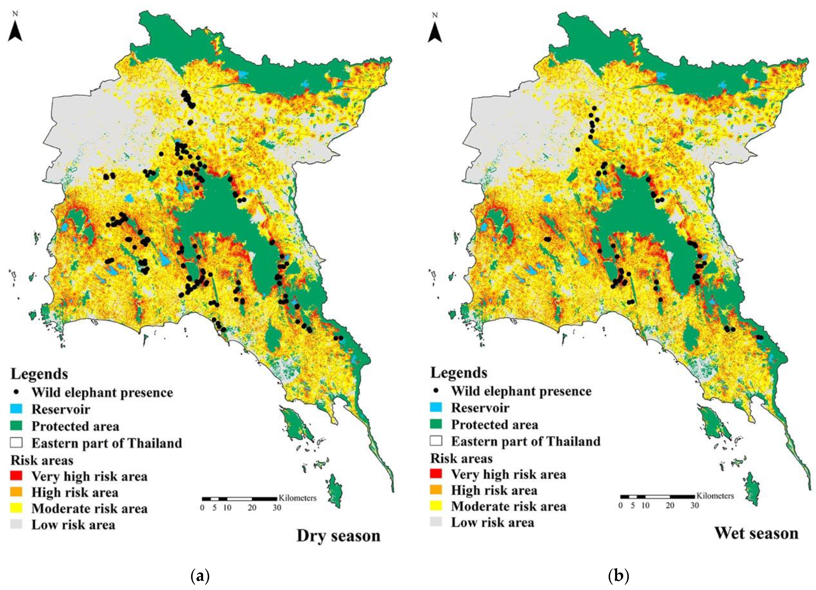
3.2. The Risk of Human–Elephant Conflicts in the Eastern Part of Thailand

From the species distribution model, we assessed that the suitable habitat area for elephants outside the protected areas potentially increases the risk of HEC. In 2020, the high-risk areas in the eastern part of Thailand increased the most compared to the years 2000, 2006, 2010, 2016, and 2020. The risk areas of HEC were greater in the dry season rather than in the wet season (Table 1 and Figure 3). Very high-risk areas were highest in 2020 (375.8 km2). Very high-risk areas were found mainly along the border of the protected areas (Figure 3). The jackknife training grain was used to evaluate the associations between environmental parameters and the distribution of wild Asian elephants in the eastern part of Thailand. In the wet season, the wild elephants tended to live in the protected areas, rather than entering agricultural areas (Figure 4). The suitable SDMs were evaluated by AUC < 0.7. Therefore, the AUC in all maps was higher than 0.7, indicating that the SDMs were suitable for explaining the distribution of wild elephants in the area (Figure 5).

3.3. The Human-Elephant Conflict in the Eastern Part of Thailand

The wild elephants have entered agricultural areas since 2000, mostly in the northern part of KARN. The distribution of wild elephants expanded to the north toward Khao Yai National Park in 2010 and south toward Kung Krabaen Wildlife Sanctuary in the dry season of 2020. Western expansion toward Nam Tok Khao Chao-Khao Bo Thong Forest Park was noted in the dry season of 2016. In the dry seasons of 2020, they expanded toward the para rubber plantations in Rayong (Table 2 and Figure 6). During the dry and wet seasons of 2016, wild elephants wandered near the boundary of Khlong Khruea Wai Chaloem Phra Kiat Wildlife Sanctuary (KKWCPKWS) and NTKK. Wild elephants spread to areas with large bodies of water in the dry season, whereas during the wet season, they preferred to live in forested areas at the edges of the protected areas. In the dry season, wild elephants are typically found in large tree plantations, such as eucalyptus or para rubber trees.

3.4. Habitat Corridor of Wild Elephants

From the SDMs, in the dry season, wild elephants used 3552 habitat patches, including 253 population patches (4875 km2), 8 breeding patches (68.1 km2), and 253 other patches (193.9 km2). However, in the wet season, the number of habitat patches was reduced to 1961 patches (3850.9 km2) (Table 3).

3.5. Landscape Corridor

From habitat patches in both seasons, eight main habitat patches were selected for designing landscape corridors. Sixteen landscape corridors are shown in the dry season (Figure 6c) and 15 landscape corridors are shown in the wet season (Figure 6d). The least-cost path to the nearest habitat patches facilitating smooth movement of elephants in the eastern part of Thailand in the dry (Figure 6e) and wet (Figure 6f) seasons is shown in light pink; the high resistance patches are indicated in blue.
According to current flow centrality values, the most important habitat patches are patches A, B, D, and G because of their massive area and role in supporting the entire connection network. The landscape corridors among patches A and B, A and D, and A and G were considered the most important cost-weighted corridor values; they are the effective movement landscape corridors of elephants since they have the highest current flow centrality. However, the lowest values of current flow are found among the habitat patches A and C, A and E, A and F, B and D, C and H, E and F, E and G, F and H, and G and H (Table 4).

4. Discussion

Based on the interviews, the presence of wild elephants has increased in seven provinces of the eastern part of Thailand. The AUC of SDMs in the dry season (AUC = 0.813) was greater than it was in the wet season (AUC = 0.783) and was greater than 0.7, which was suitable for explaining the distribution of wild elephants in the area [48]. The population of wild elephants in the eastern part of Thailand and other areas is incorrect and underestimated [58]. In the eastern part of Thailand, the distribution of wild elephants outside the protected areas in the dry season was larger than it was in the wet seasons due to their movement towards bodies of water, especially built-up water sources [59], in the dry season. This is similar to a study conducted in Phu Khieo Wildlife Sanctuary that found wild elephants distributed close to water sources in the evergreen forests during the dry season [37], compared to the report of elephants in the southern region of the Kruger National Park, South Africa, using village water ponds outside the protected areas in the dry season [60].
Very high-risk areas were found mainly along the border of the protected areas. As the frequency and expansion of the risk areas of elephants entering the agricultural areas, besides the protected areas, is increasing in the eastern part of Thailand, the HEC in the area is increasing almost every year outside the protected areas, especially in the dry season, as found in the Chanthaburi Province [8] and the Chure Terai Madhesh Landscape of Nepal [61]. An increase in land use and forest patchiness has contributed to an increase in habitat suitability, which will be the risk area. The results showed that the distance from reservoirs was associated with the distribution of wild Asian elephants, and that extreme drought can alter the distribution and abundance of the elephant population, leading to mass starvation [62]. Considering the dry season, the distribution of wild elephants is broader due to drought events and the lack of sufficient water sources in the forest.
Wild elephants consistently prefer low slope areas (<20% and Vinitpornsawan [37], Temchai et al. [63], and Wilson et al. [64] reported that slope preference was not significantly different between the two seasons. In contrast, wild elephants have varying preferences for altitude. Elephants were found to appear at altitudes not exceeding 60 m during the dry season but were at 200–400 m during the wet season. They were at an altitude over 900 m in Phu Kheio Wildlife Sanctuary [3]; however, Temchai et al. [63] reported that these were the wild elephants who were living at an altitude of more than 350 m asl.
The road surface was used by elephants for passing or foraging [65]. Roads had an influence on wild elephants being attracted to come outside the forest area, especially during the dry season. In contrast, in the past five years, the roads had less influence in the wet season, as found in Nepal, where roads were the main environmental parameter affecting the distribution of wild elephants [66]. However, elephants in large numbers were attracted to the roads in more abundant secondary forests and open habitats that contained more food sources [67]. Moreover, during natural food shortages, wild elephants were forced to live in agricultural and residential areas. Wild elephants were more likely to be found using agricultural areas during the wet season than during the dry season, as the rice fields were in the harvesting phase [68]. In the eastern part of Thailand, the distribution of wild elephants in the agricultural areas was higher in the dry season than in the wet season due to their attraction to artificial ponds in agricultural areas.
Bahar et al. [69] found that elephants were not found in villages but were often seen in para rubber and palm oil plantations because of their abundant food supply. This was consistent with our result that wild elephants avoid human communities. However, Tripathy et al. [70] found that wild elephants entered villages within 200 m to 1 km distance adjacent to the forest edge because of easy access to food from households.
Due to wild elephants being an important part of ecosystems, corridors for elephants also benefit other species. Therefore, maintaining connectivity for elephants helps maintain connectivity for other species [2]. However, the overlapping areas of the corridors are filled with forest and agricultural areas. Even though the optimal paths were the effective corridors for elephant movements, in reality, it was problematic to create corridors. Trisurat et al. [71] considered that potential passageways composed of plantations, agricultural areas, community forests, and forests outside protected areas were essential and must be considered to resolve many conservation problems. The negotiation between the villagers and authorities on these problems must be resolved by discussing the benefits of migration of HEC along the sides of the corridors and other benefits that the landowner will gain from this conservation practice [72,73].

5. Conclusions

In 2020, wild elephants were frequently found outside forest areas in the dry season, and the distribution of wild elephants has expanded to be even more than it was 10 years ago. The distribution pattern of wild elephants is mainly in the forests during the wet season. There has always been some elephant activity outside the forest area, although there has been an increase in the distribution of wild elephants outside the forest areas in recent years. The reserved forests that are scattered in the eastern part of Thailand and this separation are the main environmental factors that induce the wild elephants to enter agricultural areas. The increasing number of artificial water sources and roads are the second and third environmental factors, respectively, that affect the wild elephants’ movement into the agricultural areas in the eastern part of Thailand.
To reduce the habitat suitability and risk in the area, the natural habitats and human-made landscape corridors used by wild elephants can provide potential landscape corridors between habitats. However, these naturally made corridors overlap various types of land use areas. Therefore, consideration should be given to the possibility of changing the use of the landscape to construct the linkage corridor.
In the overlapping areas between agricultural areas and the landscape corridors, wild elephant mobility was impeded. Moreover, when they might cross the landscape corridors, they may disturb the cash crops. Therefore, an effective boundary between landscape corridors and the agricultural areas must be provided to avoid crop damage in the areas. Strict law enforcement and crop damage compensation are necessary to reduce the HEC along the elephant landscape corridors. Wild elephants probably use different paths when they cross the habitat patches; therefore, the study of elephant behavior and assessment of the actual habitat corridors are recommended. Furthermore, the connectivity between habitat patches can exist if the local communities agree to manage the wild elephants in the eastern part of Thailand.

Author Contributions

Conceptualization, R.C. and M.W.; methodology, M.W. and R.C.; software, M.W.; validation, R.C. and N.Y.; formal analysis, M.W. and N.Y.; investigation, M.W. and N.C.; resources, R.C. and N.C.; data curation, M.W. and N.C.; writing—original draft preparation, M.W.; writing—review and editing, R.C.; visualization, R.C.; supervision, R.C.; project administration, R.C.; funding acquisition, R.C. All authors have read and agreed to the published version of the manuscript.

Funding

This research was funded by the Mahidol University and Program Management Unit (PMU, 2021), National Innovation Agency (NIA), Fundamental Fund: Basic Research Fund (BRF2-NDFR33/2564), Thailand for supporting our research.

Institutional Review Board Statement

The study was conducted in accordance with the Declaration of Helsinki and approved by the Institutional Review Board of Mahidol University—Institute Animal Care and Use Committee (MU—CIRB 2020/123.2605, 4 June 2020). The animal study protocol was approved by the Institutional Review Board of Mahidol University—Institute Animal Care and Use Committee (MU—IACUC No. F02-63-004, 1 May 2020).

Informed Consent Statement

Not applicable.

Data Availability Statement

Not applicable.

Acknowledgments

The authors thank the villagers in the eastern part of Thailand for their participation. We also thank Perapong Norachart, Thongchai Ketsamut, Thanadol Metta, Pitak Yingyong, and field assistants for sharing data, and for helping to collect data in the eastern part of Thailand.

Conflicts of Interest

The authors declare no conflict of interest.

References

  1. Chaiyarat, R.; Youngpoy, N.; Prempree, P. Wild Asian elephant (Elephas maximus) population in Salakpra Wildlife Sanctuary, Thailand. Endanger. Species Res. 2015, 29, 95–102. [Google Scholar] [CrossRef] [Green Version]
  2. Neupane, D.; Kwon, Y.; Risch, T.S.; Williams, A.C.; Johnson, R.L. Habitat use by Asian elephants: Context matters. Global Ecol. Conserv. 2019, 17, e00570. [Google Scholar] [CrossRef]
  3. Htet, N.N.P.; Chaiyarat, R.; Thongthip, N.; Anuracpreeda, P.; Youngpoy, N.; Chompoopong, P. Population and distribution of wild Asian elephants (Elephas maximus) in Phu Khieo Wildlife Sanctuary, Thailand. PeerJ 2021, 29, e11896. [Google Scholar] [CrossRef] [PubMed]
  4. Leimgruber, P.; Gagnon, J.B.; Wemmer, C.; Kelly, D.S.; Songer, M.A.; Selig, E.R. Fragmentation of Asia’s remaining wildlands: Implications for Asian elephant conservation. Anim. Conserv. 2003, 6, 347–359. [Google Scholar] [CrossRef] [Green Version]
  5. Shannon, G.; Matthews, W.S.; Page, B.R.; Parker, G.E.; Smith, R.J. The effects of artificial water availability on large herbivore ranging patterns in savanna habitats: A new approach based on modelling elephant path distributions. Divers. Distrib. 2009, 15, 776–783. [Google Scholar] [CrossRef]
  6. Montez, D.; Leng, A. Status of Asian elephant and Human—Elephant conflict (HEC) in Asia: A brief and updated review. J. Nat. Appl. Res. 2021, 1, 28–35. [Google Scholar]
  7. Ram, A.K.; Mondol, S.; Subedi, N.; Lamichhane, B.R.; Baral, H.S.; Natarajan, L.; Amin, R.; Pandav, B. Patterns and determinants of elephant attacks on humans in Nepal. Ecol. Evol. 2021, 11, 11639–11650. [Google Scholar] [CrossRef]
  8. Kitratporn, N.; Takeuchi, W. Spatiotemporal distribution of Human-elephant Conflict in eastern Thailand: A model–based assessment using news reports and remotely sensed data. Remote Sens. 2020, 12, 90. [Google Scholar] [CrossRef] [Green Version]
  9. Mumby, H.S.; Plotnik, J.M. Taking the elephants’ perspective: Remembering elephant behavior, cognition and ecology in human-elephant conflict mitigation. Front. Ecol. Evol. 2018, 6, 122. [Google Scholar] [CrossRef] [Green Version]
  10. Bal, P.; Nath, C.; Nanaya, K.; Kushalappa, C.; Garcia, C. Elephants also like coffee: Trends and drivers of human–elephant conflicts in coffee agroforestry landscapes of Kodagu, Western Ghats, India. Environ. Manag. 2011, 47, 789–801. [Google Scholar] [CrossRef]
  11. Neupane, D.; Johnson, R.L.; Risch, T.S. Temporal and spatial patterns of human–elephant conflict in Nepal. In Proceedings of the International Elephant & Rhino Conservation & Research Symposium, Pittsburgh Zoo & PPG Aquarium, Pittsburgh, PA, USA, 26–30 August 2013. [Google Scholar]
  12. Cook, R.M.; Parrini, F.; Henley, M.D. Elephant movement patterns in relation to human inhabitants in and around the Great Limpopo Transfrontier Park. Koedoe. Afr. Protect. Area Conserv. Sci. 2015, 57, 1–7. [Google Scholar]
  13. Goswami, V.R.; Medhi, K.; Nichols, J.D.; Oli, M.K. Mechanistic understanding of human–wildlife conflict through a novel application of dynamic occupancy models. Conserv. Biol. 2015, 29, 1100–1110. [Google Scholar] [CrossRef] [PubMed]
  14. Wilson, S.; Davies, T.E.; Hazarika, N.; Zimmermann, A. Understanding spatial and temporal patterns of human–elephant conflict in Assam, India. Oryx 2015, 49, 140–149. [Google Scholar] [CrossRef] [Green Version]
  15. Wettasin, M.; Chaiyarat, R.; Yongpoy, N.; Cheachean, N.; Sukmasuang, R.; Tanhan, P. Environmental factors influenced the distribution of wild Asian elephant (Elephas maximus) in rural areas of the Eastern Economic Corridor, Thailand. 2022; In preparation. [Google Scholar]
  16. Mimet, A.; Clauzel, C.; Foltête, J.-C. Locating wildlife crossings for multispecies connectivity across linear infrastructures. Landsc. Ecol. 2016, 31, 1955–1973. [Google Scholar] [CrossRef]
  17. Crooks, K.R.; Burdett, C.L.; Theobald, D.M.; King, S.; Di Marco, M.; Rondinini, C.; Boitani, L. Quantification of habitat fragmentation reveals extinction risk in terrestrial mammals. Proc. Natl. Acad. Sci. USA 2017, 114, 7635–7640. [Google Scholar] [CrossRef] [Green Version]
  18. Alkemade, R.; van Oorschot, M.; Miles, L.; Nellemann, C.; Bakkenes, M.; Ten Brink, B. GLOBIO3: A framework to investigate options for reducing global terrestrial biodiversity loss. Ecosystem 2009, 12, 374e390. [Google Scholar] [CrossRef] [Green Version]
  19. Williams, C.; Tiwari, S.K.; Goswami, V.R.; de Silva, S.; Kumar, A.; Baskaran, N.; Yoganand, K.; Menon, V. Elephas maximus (Asian Elephant). IUCN Red List Threat. Species 2020: E.T7140A45818198. Available online: https://asesg.org/PDFfiles/Asian%20Elephant%20Red%20List%20Assessment%202020.pdf (accessed on 20 December 2020).
  20. Campos-Arceiz, A.; Larrinaga, A.R.; Weerasinghe, U.R.; Takatsuki, S.; Pastorini, J.; Leimgruber, P.; Fernando, P.; Santamaría, L. Behavior rather than diet mediates seasonal differences in seed dispersal by Asian elephants. Ecology 2008, 89, 2684–2691. [Google Scholar] [CrossRef] [Green Version]
  21. Fritz, H. Long-term field studies of elephants: Understanding the ecology and conservation of a long-lived ecosystem engineer. J. Mammal. 2017, 98, 603–611. [Google Scholar] [CrossRef]
  22. Sekar, N.; Lee, C.; Sukumar, R. Functional non redundancy of elephants in a disturbed tropical forest. Conserv. Biol. 2017, 31, 1152–1162. [Google Scholar] [CrossRef]
  23. Poulsen, J.R.; Rosin, C.; Meier, A.; Mills, E.; Nuñez, C.L.; Koerner, S.; Blanchard, E.; Callejas, J.; Moore, S.; Sowers, M. Ecological consequences of forest elephant declines for Afrotropical forests. Conserv. Biol. 2018, 32, 559–567. [Google Scholar] [CrossRef] [PubMed]
  24. Sukumar, R. A brief review of the status, distribution and biology of wild Asian elephants Elephas maximus. Int. Zoo Yearb. 2006, 40, 1–8. [Google Scholar] [CrossRef]
  25. Vinitpornsawan, S.; Bunchornratana, K.; Pukhrua, A.; Panyawiwatanakul, R. Population and age structure of wild Asian elephant. Wildl. Yearb. 2015, 15, 89–111. [Google Scholar]
  26. Kumar, S. Attack on elephant by tiger, a choice of food or struggle for survival, ecological study in Corbett Tiger Reserve, Ramnagar and Uttrakhand, India. Int. J. Life. Sci. Scienti. Res. 2016, 2, 506–508. [Google Scholar] [CrossRef]
  27. Rabinowitz, A.; Zeller, K.A. A range–wide model of landscape connectivity and conservation for the jaguar, Panthera onca. Biol. Conserv. 2010, 143, 939–945. [Google Scholar] [CrossRef]
  28. Cushman, S.A.; Landguth, E.L.; Flather, C.H. Evaluating population connectivity for species of conservation concern in the American Great Plains. Biodivers. Conserv. 2013, 22, 2583–2605. [Google Scholar] [CrossRef] [Green Version]
  29. Torrubia, S.; McRae, B.H.; Lawler, J.J.; Hall, S.A.; Halabisky, M.; Langdon, J.; Case, M. Getting the most connectivity per conservation dollar. Front. Ecol. Environ. 2014, 12, 491–497. [Google Scholar] [CrossRef]
  30. Wade, A.A.; Mckelvey, K.S.; Schwartz, M.K. Resistance–Surface–Based Wildlife Conservation Connectivity Modeling: Summary of Efforts in the United States and Guide for Practitioners; Gen. Tech. Rep. Gen. Tech. Rep. RMRS-GTR-333; Department of Agriculture, Forest Service, Rocky Mountain Research Station: Fort Collins, CO, USA, 2015; 93p. [Google Scholar]
  31. Schlaepfer, D.R.; Braschler, B.; Rusterholz, H.-P.; Baur, B. Genetic effects of anthropogenic habitat fragmentation on remnant animal and plant populations: A meta-analysis. Ecosphere 2018, 9, e02488. [Google Scholar] [CrossRef]
  32. Fawcett, T. An introduction to ROC analysis. Pattern Recognit. Lett. 2006, 27, 861–874. [Google Scholar] [CrossRef]
  33. Royal Thai Embassy, Washington, D.C. Thailand Taking 4.0 Regional as ASEAN Chair. Available online: https://thaiembdc.org/2019/02/18/thailand-taking-4-0-regional-as-asean-chair/ (accessed on 30 November 2020).
  34. Thurfjell, H.; Ciuti, S.; Boyce, M.S. Applications of step–selection functions in ecology and conservation. Mov. Ecol. 2014, 2, 4. [Google Scholar] [CrossRef] [Green Version]
  35. DNP. Eastern Forest Complex in Thailand. Available online: http://www.dnp.go.th/wildlife_it/n_web/the_wild/KPA.php. (accessed on 30 November 2018).
  36. Suksawang, S.; Temchai, T. Report on Water Yield in Eastern Forest Complex (EFCOM); National Parks Office, Department of National Park, Wildlife and Plant Conservation: Bangkok, Thailand, 2017.
  37. Pomoim, N.; Trisurat, Y.; Hughes, A.C.; Corlett, R.T. Can Thailand protect 30% of its land area for biodiversity, and will this be enough? Diversity 2022, 14, 344. [Google Scholar] [CrossRef]
  38. Suksavate, W.; Duengkae, P.; Chaiyes, A. Quantifying landscape connectivity for wild Asian elephant populations among fragmented habitats in Thailand. Global Ecol. Conserv. 2019, 19, e00685. [Google Scholar] [CrossRef]
  39. Chumsangsri, T. GIS for Analysis of the Elephant Habitat in Taboh–Huai Yai Wildlife Sanctuary, Changwat Phtchabun and Chaiyaphum. Master’s Thesis, Kasetsart University, Bangkok, Thailand, 2002. [Google Scholar]
  40. Vinitpornsawan, S. Application of GIS to the Analysis of the Distribution of the Elephant (Elephas Maximus Linnaeus, 1758) at Phu Khieo Wildlife Sanctuary, Chaiyaphum Province; Biodiversity Research and Training Program (BRT): Bangkok, Thailand, 2003; pp. 228–234. [Google Scholar]
  41. Chokcharoen, R.; Sukmasuang, R. Ecology of Asian elephant (Elephas maximus) in Phu Wua Wildlife Sanctuary, Bueng Kan Province. J. Wildl. Thail. 2012, 19, 13–22. [Google Scholar]
  42. Podchong, S. A Complete Research Project Report: Assessing the Suitable Habitat of Important Wildlife Species in the Phu Khiao–Nam Nao Forest Area; Wildlife Conservation Information Division, Department of National Parks, Wildlife and Plant Conservation: Bangkok, Thailand, 2015. [Google Scholar]
  43. Raksapol, P. Habitat Corridors of Wild Elephant (Elephas maximus) at Salakpra Wildlife Sanctuary and Nearby Areas, Kanchanaburi Province; M.S. Kasetsart University: Bangkok, Thailand, 2019. [Google Scholar]
  44. Phillips, S.J.; Anderson, R.P.; Schapire, R.E. Maximum entropy modeling of species geographic distributions. Ecol. Modell. 2006, 190, 231–259. [Google Scholar] [CrossRef] [Green Version]
  45. Elith, J.; Graham, C.H.; Anderson, R.P.; Dudı’k, M.; Ferrier, S.; Guisan, A.; Hijmans, R.J.; Huettmann, F.; Leathwick, J.R.; Lehmann, A.; et al. Novel methods improve prediction of species’ distributions from occurrence data. Ecography 2016, 29, 129–151. [Google Scholar] [CrossRef]
  46. Jaynes, E.T. Information theory and statistical mechanics. Phys. Rev. 1957, 106, 620–630. [Google Scholar] [CrossRef]
  47. Rodrigues, E.S.D.C.; Rodrigues, F.A.; Ricardo, L.D.A.; Corrêa, P.L.; Giannini, T.C. Evaluation of different aspects of maximum entropy for niche–based modeling. Procedia Environ. Sci. 2010, 2, 990–1001. [Google Scholar] [CrossRef] [Green Version]
  48. Mullu, D. A review on the effect of habitat fragmentation on ecosystem. J. Nat. Sci. Res. 2016, 6, 1–15. [Google Scholar]
  49. Beier, P.; Noss, F.R. Do habitat corridors provide connectivity? Conserv. Biol. 1998, 12, 1241–1252. [Google Scholar] [CrossRef]
  50. Gilbert-Norton, L.; Wilson, R.; Stevens, J.R.; Beard, K.H. A Meta-Analytic Review of Corridor Effectiveness. Conserv. Biol. 2010, 24, 660–668. [Google Scholar] [CrossRef]
  51. Ford, T.; Rettie, K.; Clevenger, A.P. Fostering ecosystem function through an international public–private partnership: A case study of wildlife mitigation measures along the Trans-Canada Highway in Banff National Park, Alberta, Canada. Int. J. Biodivers. Sci. Manag. 2009, 5, 181–189. [Google Scholar] [CrossRef] [Green Version]
  52. Beier, P.; Majka, D.R.; Spencer, W.D. Forks in the road: Choices in procedures for designing wildland linkages. Conserv. Biol. 2008, 22, 836–851. [Google Scholar] [CrossRef] [PubMed]
  53. Majka, D.; Jenness, J.; Beier, P. CorridorDesigner: ArcGIS Tools for Designing and Evaluating Corridors. Available online: http://corridordesign.org (accessed on 20 November 2020).
  54. Gunawan, G.; Sulistijorini, S.; Chikmawati, T.; Sobir, S. Predicting suitable areas for Baccaurea angulata in Kalimantan, Indonesia using Maxent modeling. Biodiversitas J. Biol. Divers. 2021, 22, 2646–2653. [Google Scholar] [CrossRef]
  55. Adriaensen, F.; Chardon, J.P.; De Blust, G.; Swinnen, E.; Villalba, S.; Gulinck, H.; Matthysen, E. The application of “least–cost” modelling as a functional landscape model. Landsc. Urban Plan 2003, 64, 233–247. [Google Scholar] [CrossRef]
  56. McRae, B.H.; Dickson, B.G.; Keitt, T.H.; Shah, V.B.; Mcrae, H. Using circuit theory to model connectivity in ecology. Evol. Conserv. Ecol. 2008, 89, 2712–2724. [Google Scholar] [CrossRef]
  57. Carroll, C.; McRae, B.H.; Brookes, A. Use of linkage mapping and centrality analysis across habitat gradients to conserve connectivity of gray wolf populations in western North America. Conserv. Biol. 2012, 26, 78–87. [Google Scholar] [CrossRef]
  58. Silva, S.D.; Wu, T.; Nyhus, P.; Thieme, A.; Weaver, A.; Johnson, J.; Wadey, J.; Mossbrucker, A.; Vu, T.; Neang, T.; et al. The past, present and future of elephant landscapes in Asia. bioRxiv 2020. [Google Scholar] [CrossRef]
  59. Sutherland, K.; Ndlovu, M.; Pérez-Rodríguez, A. Use of artificial waterholes by animals in the southern region of the Kruger National Park, South Africa. Afr. J. Wildl. Res. 2018, 48, 023003. [Google Scholar] [CrossRef]
  60. Kroutnoi, L.; Sriburi, T.; Wijitkosum, S.; Nuanyai, K. Determination of stimulating factors of wild Asian elephant (Elephas maximus) dispersal from the Kaeng Krachan National Park to surrounding land use in Thailand. Walailak J. Sci. Technol. 2020, 17, 392–404. [Google Scholar] [CrossRef]
  61. Ram, A.K.; Yadav, N.K.; Subedi, N.; Pandav, B.; Mondol, S.; Khanal, B.; Kharal, D.K.; Acharya, H.B.; Dhakal, B.K.; Acharya, K.P.; et al. Landscape predictors of human elephant conflicts in Chure Terai Madhesh Landscape of Nepal. Environ. Chall. 2022, 7, 100458. [Google Scholar] [CrossRef]
  62. Wato, Y.A.; Heitkönig, I.M.A.; Wieren, V.S.E.; Wahungu, G.; Prins, H.H.T.; Langevelde, V.F. Prolonged drought results in starvation of African elephant (Loxodonta africana). Biol. Conserv. 2016, 203, 89–96. [Google Scholar] [CrossRef]
  63. Temchai, T.; Kaewkate, C.; Hengswang, D.; Saengswang, M.; Deekaew, P.; Vanmanee, S.; Jitra, N.; Thongsuk, P.; Thongkerd, T.; Khamkran, S.; et al. Population survey of Asian elephant (Elephas maximus) in Kaeng Krachan national park, Thailand. J. Thail. Natl. Park. Res. 2018, 2, 112–121. [Google Scholar]
  64. Wilson, G.; Gray, R.J.; Radinal, R.; Hasanuddin, H.; Azmi, W.; Sayuti, A.; Muhammad, H.; Abdullah, A.; Nazamuddin, B.S.; Sofyan, H.; et al. Between a rock and a hard place: Rugged terrain features and human disturbance affect behaviour and habitat use of Sumatran elephants in Aceh, Sumatra, Indonesia. Biodiver. Conserv. 2021, 30, 597–618. [Google Scholar] [CrossRef]
  65. Pan, W.; Lin, L.; Luo, A.; Zhang, L. Corridor use by Asian elephants. Integ. Zool. 2009, 4, 220–231. [Google Scholar] [CrossRef] [PubMed]
  66. Tripathy, B.R.; Liu, X.; Songer, M.; Zahoor, B.; Wickramasinghe, W.M.S.; Mahanta, K.K. Analysis of landscape connectivity among the habitats of Asian elephants in Keonjhar Forest Division, India. Remote Sens. 2021, 13, 4661. [Google Scholar] [CrossRef]
  67. Wadey, J.; Beyer, H.L.; Saaban, S.; Othman, N.; Leimgruber, P.; Campos-Arceiz, A. Why did the elephant cross the road? The complex response of wild elephants to a major road in Peninsular Malaysia. Biol. Conserv. 2018, 218, 91–98. [Google Scholar] [CrossRef]
  68. Trisurat, Y.; Bhumpakphan, N.; Reed, D.H.; Kanchanasaka, B. Using species distribution modeling to set management priorities for mammals in northern Thailand. J. Nat. Conserv. 2012, 20, 264–273. [Google Scholar] [CrossRef]
  69. Sharma, P.S.; Panthi Yadav, S.K.; Bhatta, M.; Karki, A.; Duncan, T.; Poudel, M.; Acharya, K.P. Suitable habitat of wild Asian elephant in Western Terai of Nepal. Ecol. Evol. 2020, 10, 6612–6619. [Google Scholar] [CrossRef]
  70. Krishnan, V.; Kumar, M.A.; Raghunathan, G.; Vijayakrishnan, S. Distribution and habitat use by Asian elephants (Elephas maximus) in a coffee–dominated landscape of Southern India. Trop. Conserv. Sci. 2019, 12, 1940082918822599. [Google Scholar] [CrossRef]
  71. Bahar, A.; Kasim, N.H.A.B.; Hambali, K. Home range and movement patterns of Asian elephant (Elephas maximus) in Gua Musang, Kelantan, Malaysia. Malay. Nat. J. 2018, 70, 221–232. [Google Scholar]
  72. Noe, C. The Dynamics of Land Use Changes and Their Impacts on the Wildlife Corridor between Mt. Kilimanjaro and Amboseli National Park, Tanzania; LUCID Working Paper Number: 31; LUCID Project International Livestock Research Institute: Nairobi, Kenya, 2003. [Google Scholar]
  73. Sengelela, M. Local People Perceived Benefit and Costs of Trans–Frontier Conservation Areas: The Case of Likuyusekamaganga Village in Selous–Niassa Trans–Frontier Conservation Area. Master’s Thesis, Cultural Geography, Wageningen University, Wageningen, The Netherlands, 2013. [Google Scholar]
Figure 2. Land use of the eastern part of Thailand in 2020: (a) road, (b) reservoir, and (c) agricultural area.
Diversity 15 00006 g002
Figure 3. Human-elephant conflict areas found in 183 households and the risk areas between human-elephant conflict in 2020 in the eastern part of Thailand in (a) the dry season and (b) the wet season.
Diversity 15 00006 g003
Figure 4. Environmental parameters that related to wild elephant distribution in 2020: (a) the dry season and (b) the wet season.
Diversity 15 00006 g004
Figure 5. The area under the Receiver Operating Characteristic (ROC) curve (AUC) of wild elephant distribution models in 2020: (a) the dry season and (b) the wet season.
Diversity 15 00006 g005
Figure 6. Habitat patches of wild elephants in (a) the dry season and (b) the wet season; least-cost path in maintaining a corridor within the entire habitat network of the eastern part of Thailand in (c) the dry season and (d) the wet season; the corridor identified according to least-cost area (low resistance is light pink color and high resistance is blue color) analysis in (e) the dry season and (f) the wet season in 2020.
Diversity 15 00006 g006aDiversity 15 00006 g006b
Table 1. Risk areas between human-elephant conflict in the dry season and the wet season in 2020 in the eastern part of Thailand.
SeasonVery High Risk AreaHigh Risk AreaModerate Risk AreaLow Risk AreaTotal
km2Presence (Points)km2Presence (Points)km2Presence (Points)km2Presence (Points)km2Points
Dry375.8702060.1489505.45224,115.63236,056.9202
Wet225.825915183397.72031,827936,365.572
Table 2. The area of eight important habitat patches of wild elephants in the eastern part of Thailand.
PatchesHabitat PatchArea (km2)
Dry SeasonWet Season
AKhao Ang Rue Nai Wildlife Sanctuary2440.52082.2
Khao Soi Dao Wildlife Sanctuary
Khao Sip Ha Chan National Park
Khao Khitchakut National Park
BKhlong Khruea Wai Chaloem Phra Kiat Wildlife Sanctuary539.1374
Namtok Khlong Kaeo National Park
CNamtok Phlio National Park31.723.1
DPang Sida National Park1446.41099.9
Ta Phraya National Park
Thap Lan National Park
EKhao Yai National Park229.160.8
FKao Kheow-Kao Chomphu Wildlife Sanctuary184.8115.2
GKhao Yai Da Non-hunting Area (In preparation area)54.619.5
HNam Tok Khao Chao-Bo Thong Forest Park36.313.4
Table 3. Habitat patch of wild elephant in the eastern part of Thailand in 2020.
Patch TypeDry SeasonWet Season
Number of Patches (Patch)Area (km2)Number of Patches (Patch)Area (km2)
Population patch25348752233627.3
Breeding patch868.133150.5
Other patch3291193.9170573.1
Total3552513719613850.9
Table 4. The landscape corridors with Euclidean distance, cost-weighted distance, least-cost path distance, effective resistance, and core centrality of wild elephants in the eastern part of Thailand.
SeasonLandscape CorridorLandcoverEuclidean Distance (Km)Cost-Weighted Distance (Km)Least-Cost Path Distance (Km)Effective ResistanceCore Centrality
DryA to BPerennial crop/agriculture/evergreen/deciduous1.71.90.71.112
A to CPerennial crop/agriculture/evergreen/deciduous24.531.23.7−1−1
A to DPerennial crop/agriculture/evergreen/deciduous52.868.293.612
A to EPerennial crop/agriculture/evergreen/deciduous57.981.69−1−1
A to FPerennial crop/agriculture/evergreen/deciduous49.3151.29.3−1−1
A to GPlantation/agriculture/
deciduous
20.523.65.92.912
A to HPerennial crop/agriculture/evergreen/deciduous35.942.65.55.57
B to CPlantation/agriculture/
deciduous
17.42742.97
B to DPerennial crop/agriculture/evergreen/deciduous119.9146.516.7−1−1
C to HPerennial crop /agriculture/
deciduous
80.6118.912.6−1−1
D to EPerennial crop /agriculture/
deciduous
0.30.30.20.37
E to FPerennial crop /agriculture/
deciduous
97.9192.89.1−1−1
E to GPerennial crop /agriculture/
deciduous
96.3180.110.3−1−1
F to GPerennial crop /agriculture/
deciduous
19.924.64.88.47
F to HPerennial crop /agriculture/
deciduous
45.35810.4−1−1
G to HPerennial crop /agriculture/
deciduous
42.953.29.4−1−1
Disclaimer/Publisher’s Note: The statements, opinions and data contained in all publications are solely those of the individual author(s) and contributor(s) and not of MDPI and/or the editor(s). MDPI and/or the editor(s) disclaim responsibility for any injury to people or property resulting from any ideas, methods, instructions or products referred to in the content.

