Article

Exploring the Spatial and Temporal Patterns of Children and Adolescents with COVID-19 Infections in Slovakia during March 2020 to July 2022

by
Ahmad Gharaibeh
1,*,
Mamoun A. Gharaibeh
2,*,
Siham Bataineh
3 and
Anna Maria Kecerová
4
1
Teaching Department of Orthopaedics Musculoskeletal Trauma, Faculty of Medicine, University Hospital of Louise Pasteur, Pavel Jozef Safarik University, 040 11 Košice, Slovakia
2
Department of Natural Resources and the Environment, Faculty of Agriculture, Jordan University of Science and Technology, P.O. Box 3030, Irbid 22110, Jordan
3
Department of Civil Engineering, Faculty of Engineering, Jordan University of Science and Technology, P.O. Box 3030, Irbid 22110, Jordan
4
Social Insurance Headquarter, 040 84 Košice, Slovakia
*
Authors to whom correspondence should be addressed.
Medicina 2024, 60(6), 931; https://doi.org/10.3390/medicina60060931
Submission received: 16 April 2024 / Revised: 11 May 2024 / Accepted: 30 May 2024 / Published: 2 June 2024
(This article belongs to the Section Epidemiology & Public Health)

Abstract

:
Background and Objectives: The COVID-19 pandemic has had a significant global impact, necessitating a comprehensive understanding of its spatiotemporal patterns. The objective of this study is to explore the spatial and temporal patterns of COVID-19 infections among five age groups (<1, 1–4, 5–9, 10–14, and 15–19 years) in 72 districts of Slovakia on a quarterly basis from March 2020 to July 2022. Material and Methods: During the study period, a total of 393,429 confirmed PCR cases of COVID-19 or positive antigen tests were recorded across all studied age groups. The analysis examined the spatiotemporal spread of COVID infections per quarter, from September 2021 to May 2022. Additionally, data on hospitalizations, intensive care unit (ICU) admissions, pulmonary ventilation (PV), and death cases were analyzed. Results: The highest number of COVID-19 infections occurred between September 2021 and May 2022, particularly in the 10–14-year-old group (68,695 cases), followed by the 15–19-year-old group (62,232 cases), while the lowest incidence was observed in the <1-year-old group (1235 cases). Out of the total confirmed PCR cases, 18,886 individuals required hospitalization, 456 needed ICU admission, 402 received pulmonary ventilation, and only 16 died. The analysis of total daily confirmed PCR cases for all regions showed two major peaks on 12 December 2021 (6114 cases) and 1 February 2022 (3889 cases). Spatial mapping revealed that during December 2021 to February 2022, the highest number of infections in all age groups were concentrated mainly in Bratislava. Moreover, temporal trends of infections within each age group, considering monthly and yearly variations, exhibited distinct spatial patterns, indicating localized outbreaks in specific regions. Conclusions: The spatial and temporal patterns of COVID-19 infections among different age groups in Slovakia showed a higher number of infections in the 10–14-year-old age group, mainly occurring in urban districts. The temporal pattern of the spread of the virus to neighboring urban and rural districts reflected the movement of infected individuals. Hospitalizations, ICU and PV admissions, and deaths were relatively low. The study highlights the need for more proactive measures to contain outbreaks promptly and ensure the resilience of healthcare systems against future pandemics.

1. Introduction

The coronavirus disease 2019 (COVID-19) has emerged as one of the most significant global health challenges of our time. First identified in Wuhan, China, in December 2019, the virus quickly spread across international borders, leading to a pandemic declaration by the World Health Organization (WHO) in March 2020 [1]. The first confirmed case of COVID-19 in Europe was documented in France on 24 January [2], with Slovakia officially reporting its first confirmed case six weeks later on 6 March 2020 [3]. Furthermore, as of mid-May 2023, the WHO has reported a global total of 0.766 billion confirmed COVID-19 cases, with Europe accounting for 0.276 billion cases [4].
During the period of 2020–2022, Slovakia may have been affected by several COVID-19 strains, including variants of concern such as the B.1.1.7 and B.1.351 strains, which were first reported in the UK and South Africa, respectively [5]. Slovakia may have also been affected by other COVID-19 strains such as a variant named B.1.258 Δ (approx. 59% out of 251 sequenced samples between September and December 2020); this variant has spread and gained significant prevalence in multiple countries, including the Czech Republic, Sweden, Slovakia, Poland, Denmark, and Austria [6].
As countries around the world grappled with the unprecedented impact of the disease, it became crucial to study its spatial and temporal distribution to understand its patterns and guide effective mitigation strategies. Several studies have reported the spatiotemporal spread of COVID-19 in different countries. For example, a study employing a model to examine the spatiotemporal pattern of COVID-19 transmission in the northern provinces of Italy during the initial wave in Spring 2020 revealed a significant correlation between the spread of the virus and highway connections [7]. Another study used neighborhood matrices to model the impact of border restrictions between Switzerland and Italy on the spatiotemporal spread of the virus, finding that imposing restrictions decreased the number of cases by 12% compared to no border closure, while no restrictions increased the cases by a 2.7 factor [8]. Furthermore, the implementation of geographically weighted regression models demonstrated that the distribution pattern of COVID-19 exhibited strong spatial clustering. The study revealed that the highest-risk clusters of the disease were primarily concentrated in Central and Western Europe. In Indonesia, the transmission patterns of COVID-19 during first half of the outbreak (March to August of 2020) revealed that all provinces were affected by the virus during a short period of time [9]. Furthermore, after considering various variables, it was determined that people living in poverty and elderly populations were most substantially impacted by COVID-19, as they exhibited a significant relationship with the disease [10]. A recent study in Brazil [11] showed that clusters of confirmed cases were carried from a well-developed neighborhood to socially deprived areas, along with the emergence of hotspots of the fatality rate. The influence of age groups, income, level of education, and access to essential services on the spread of COVID-19 was also verified. The recognition of variables that influence the spatial spread of the disease are vital for pinpointing the most vulnerable areas. Therefore, understanding the spatial and temporal spread of the COVID-19 outbreak is critical to predicting local outbreaks and developing public health policies during the early stages of COVID-19. In Slovakia (a landlocked country in Central Europe), the spread of the virus has presented unique challenges. The available literature shows only one spatiotemporal investigation on COVID-19 in Slovakia [12]. The study revealed that the distribution of COVID-19 cases in Slovakia is characterized by spatial heterogeneity. By examining the distribution patterns at the district level, this study aims to gain insights into the localized dynamics of the disease within the country. Analyzing the spatial and temporal distribution of COVID-19 cases can provide valuable information on spread patterns, hotspots, clusters, and the effectiveness of control measures implemented in different districts. Therefore, this manuscript aims to provide a detailed examination of the spatial and temporal distribution of COVID-19 cases among five age groups (≤19 years) within different districts of Slovakia. By shedding light on the localized patterns and dynamics of the disease, the study contributes to ongoing efforts to control and manage the impact of the pandemic, both within the country and globally.

2. Materials and Methods

Data were obtained from the National Health Information Centre (NCZI), a state-funded organization founded by the Ministry of Health of the Slovak Republic for the period spanning from 12 March 2020 to 20 July 2022 covering 72 districts (8 regions) across Slovakia. Collected data of related COVID-19 infections encompassed the following cases: (1) Polymerase Chain Reaction (PCR) positive tests, positive antigen tests, and in the early stages, positive cases measured clinically by respiratory infection, (2) hospitalized patients, (3) admissions to intensive care units (ICUs), (4) patients who received pulmonary ventilation (PV), and (5) deaths. The records were specifically limited to five age groups: <1, 1–4, 5–9, 10–14, and 15–19 years.
The coordinates (latitude and longitude) of the locations of PCR-positive, antigen test-positive, and hospitalized cases within different districts of the country were converted into shape files and geospatial maps of the total number of cases in different districts within the country were created using geographic information system (GIS) software (version 10.0). Each location is linked to its respective district boundary, and infection cases were assigned to their respective location within each district. The total number of cases in each district (on a three-month basis) were assigned different colors represent varying levels of infection rates. The total number of cases were separated into 6 categories: (1) no infections (0 cases), (2) <10, (3) 11–100, (4) 101–500, (5) 501–1000, and (6) >1000.
The maps were then used to explore the significance of changes in tracking COVID-19 infections within different districts, focusing on their regular updates every three months (spatial and temporal).
Furthermore, PCR positive cases, positive antigen tests, and in the early stages, positive cases measured clinically by respiratory infection, hospitalized cases, admissions to ICU, PV, and deaths were summarized for each district/region. Tables in Appendix A include a summary for total cases, cases in each age group, cases in each district and region, PCR positive cases, and hospitalizations per district area and population.
The criteria and measures for admission to hospitals, ICU, and PV are as follows: For the PCR test and antigen test, admission is based on suspected COVID-19 cases or positive antigen tests. Children who have been in contact with a suspected case within 2–14 days before the illness started, even if they are asymptomatic, are also admitted if they test positive or exhibit indicators such as fever, respiratory or digestive symptoms, and fatigue. Elevated markers of inflammation, liver enzyme abnormalities, and certain immunological responses are also considered. Imaging techniques like computed tomography (CT) scans, X-rays, and ultrasound examinations are used to detect lung damage. Hospitalization criteria include tachypnea without hypoxemia, oxygen saturation above 94% on atmospheric air, and chronic health problems or young age increasing the risk. Moderate pneumonia symptoms without hypoxemia or respiratory failure, as well as asymptomatic patients with positive CT scan findings, are also considered. Pediatric intensive care unit (PICU) admission criteria include oxygen saturation below 94%, severe febrile illness, dyspnea, tachypnea with cyanosis and oxygen hyposaturation (<92%), illness progression over 7–10 days, and evidence of organ dysfunction. Artificial PV is indicated for refractory hypoxia, respiratory insufficiency, and COVID-19 associated with acute respiratory distress syndrome (ARDS). High severity COVID-19 cases with complications such as shock, coagulation disorders, and organ failures also require ventilation. Severe diarrhea and illness progression over 7–10 days are additional factors for consideration.

3. Results

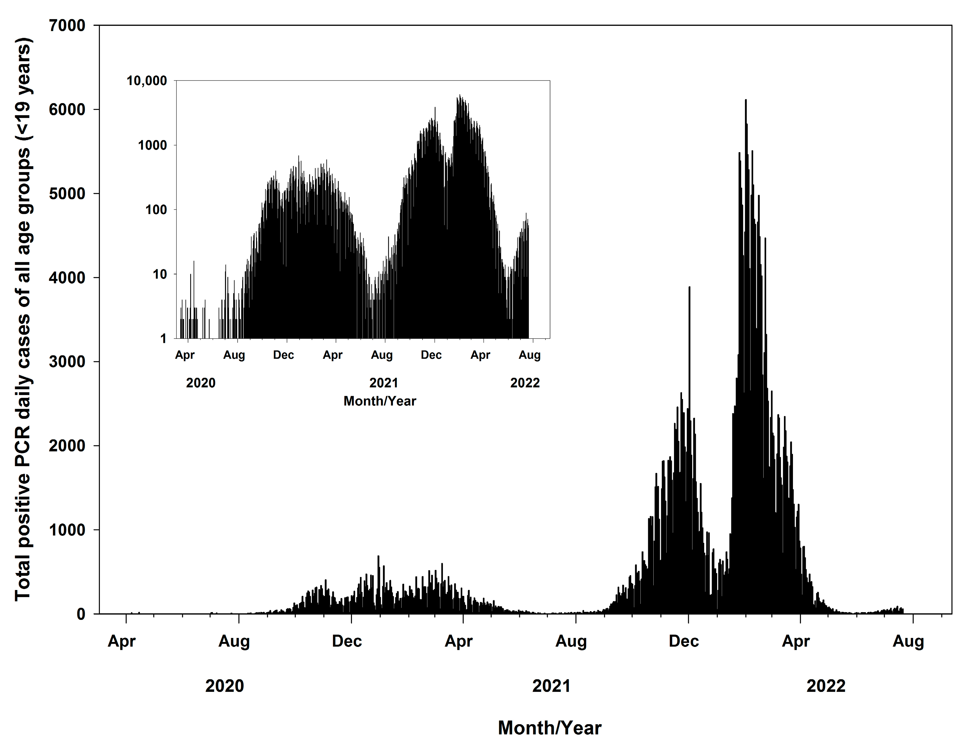
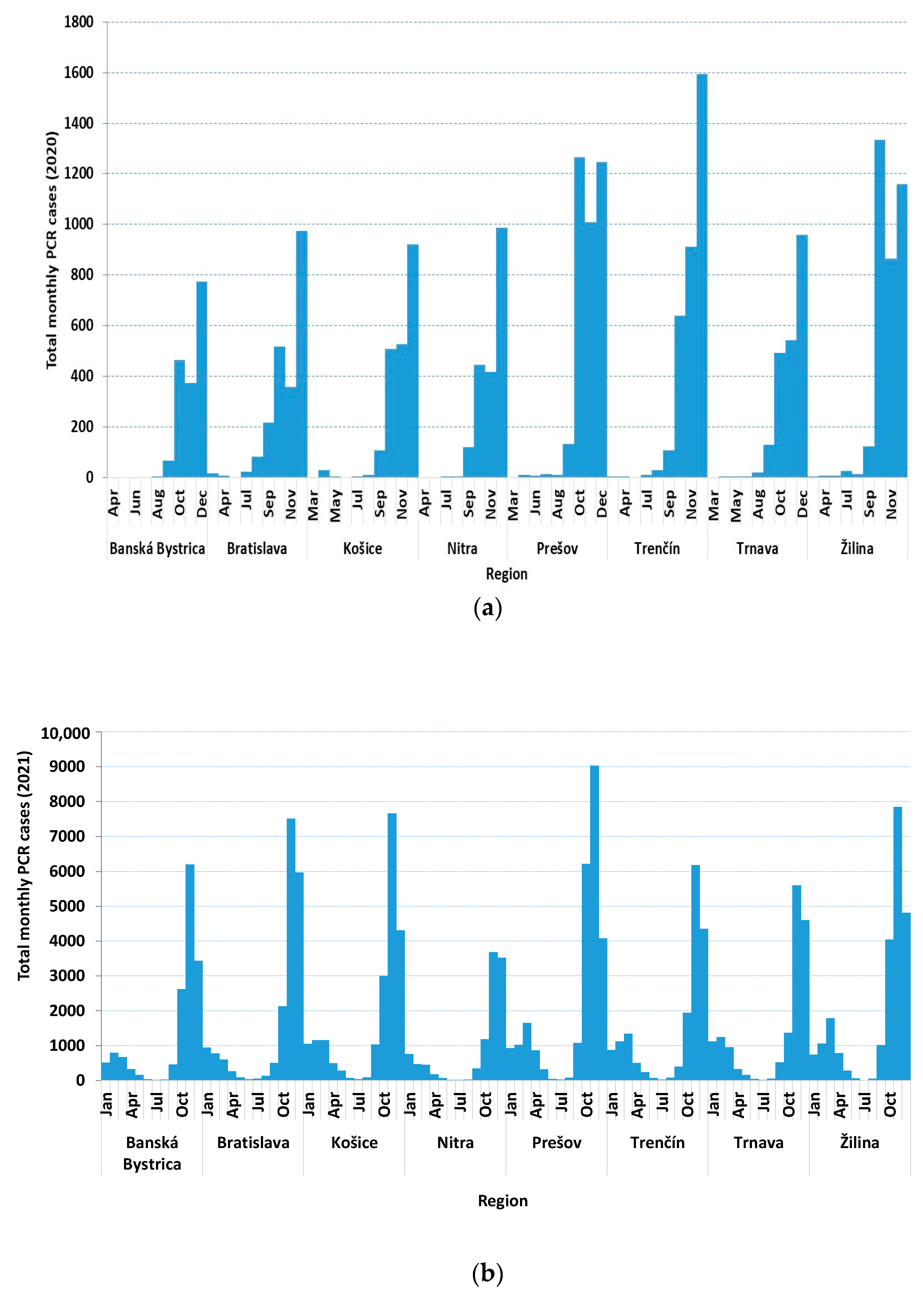
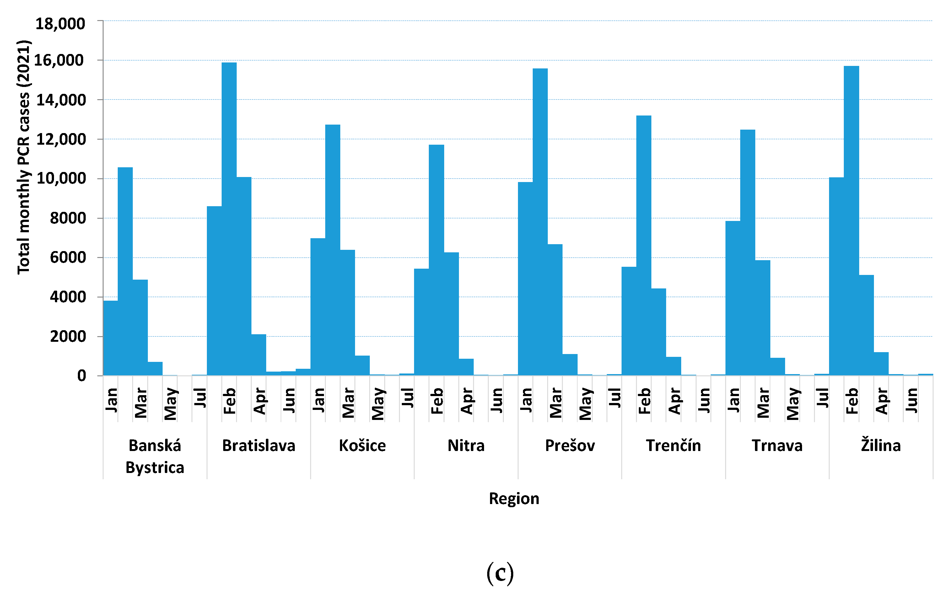
3.1. Data in General

The total positive daily PCR cases all over the country were drawn; as shown in Figure 1, the inside figure shows total cases in a logarithmic scale. The increase in total cases shows an exponential trend with three peaks occurring during the study period. The first peak occurred between September 2021 and January 2022, the second between January 2022 and March 2022, and the third between March 2022 and April 2022. The maximum total number of cases were observed on 2 December 2021 (3889/393,429, 1%), the second on 1 February 2022 (6114), and the third on 1 March 2022 (2648/393,429, 0.7%). Furthermore, during the early stages of the pandemic (October 2020 to May 2021), the total daily cases were below 700 all over the country.
A total of 393,429 positive PCR COVID-19 test cases or positive antigen test cases for all age groups were reported in Slovakia (Table A1, Appendix A). In addition, out of the total positive (393,429) cases, 18,886 (4.8%) were hospitalized, 456 (0.12%) individuals were admitted to the (PICU), 405 (0.10%) patients received pulmonary ventilation, and only 16 (0.004%) died ([Table A2, Table A3 and Table A4], Appendix A). The breakdown of the total positive cases by age group was as follows: <1-year-old group 2819 (0.72%), 1–4-year-old group 27,855 (7.08%), 5–9-year-old group 99,000 (25.16%), 10–14-year-old group 137,989 (35.07%), and 15–19-year-old group 125,766 (31.97).
The total positive PCR cases in 2020, 2021, and 2022 were 20,723, 14,6200, and 226,506, with the highest infections occurring in the Prešov 3703 (17.9%), 25,321 (17.3%), and Bratislava regions (37,444, 16.5%), respectively.
On a monthly basis, the highest number of cases in 2020 were in December (8618) in Trenčín (1594, 18.5%), while in 2021 and 2022, the highest number of cases were in November (53,700) in Prešov (9027, 16.8%), and in February (107,829) in Žilina (15,696, 14.6%), respectively.
Out of the total cases and for the whole period (393,429), the top three ranked regions were Prešov (62,377, 15.8%), Bratislava (58,635, 14.9%), and Žilina (58,361, 14.8%). On an age group basis, the highest number of infections were in the 10–14-year-old group (137,989, 35.1%) followed by the 15–19-year-old group (125,766, 32.0%), while on a yearly basis, 2020 had the highest number of infections (8122/20,723, 39.2%) for the 15–19-year-old group, and 2021 (53,351/146,200, 36.5%) and 2022 (78,029/226,506, 34.4%) had the highest number of infections for the 10–14-year-old group. In addition, for 2020 (according to the total cases of all age groups in each region), Prešov has the highest numbers (1575/3703, 42.5%) for the 15–19-year-old group; in 2021 the highest number of infections were in Prešov (9335/25,321, 36.9%) for the 10–14-year-old group, and in 2022, Bratislava ranked first (13,025/37,444, 34.9%) for the 10–14-year-old group.
The highest number of hospitalized cases (for the whole period) were in the <1-year-old group (6405 out of 18,886, 33.9%). On an age group basis, the highest admissions were in the 15–19-year-old group in 2020 (575 out of 1321, 43.5%) and 2021(1940 out of 6629, 29.3%), respectively, while in 2022, a total of 4525 out of 10,936 (41.4%) of cases in the <1-year-old group were hospitalized. Furthermore, the highest admissions (region wise) in 2020 were in Bratislava (318 out of 1321, 24.1%), in 2021 (1955 out of 6629, 29.5%) in Košice, and in 2022 (1672 out of 10,936, 15.3%) in Nitra (Table A2, Appendix A). In addition, the PICU data (Table A3, Appendix A) show that the highest admissions were in the <1-year-old group (195 out of 456, 42.8%), with the majority occurring in Nitra (140, 71.8%), followed by the 15–19-year-old group (110, 24.1%), mostly in Košice (33, 30.0%). Pulmonary ventilation data (Table A4, Appendix A) show that the highest admissions (162/405, 40.0%) occurring in the <1-year-old group were mostly in Nitra (140/162, 86.4%), followed by the 10–14-year-old group (99/405, 24.4%), out of which almost half (46/99, 46.5%) occurred in Žilina.
Cases by district and region per population and per area (case/km2) were determined for PCR antigen tests and hospitalized data (Table A1 and Table A2, Appendix A). On average, the whole country had 7.2% (393,429 case/5,459,781 population) and 8.3 (case/km2). In terms of regions (Table 1), Bratislava had the highest case/population (8.7%), while the lowest was in Nitra (5.5%). In terms of cases/km2, Bratislava came in first with 28.6, while Banská Bystrica came in last (3.9) (Table 1).
In terms of districts, Senec was the highest with 11,540 cases/94,577 population (12.2%) while the lowest was Medzilaborce–Prešov (294 cases/11,708 pop., 2.5%). For case/km2 (district wise), the highest was Bratislava (34,624 case/365 km2, 94.8) and the lowest was Medzilaborce–Prešov (294 case/472 km2, 0.7) (Table A1, Appendix A).
The total PCR cases on a monthly basis for each region for 2020, 2021, and 2022 (Figure 2a–c) were also drawn. Figure 2a shows that the highest total monthly cases for 2020 were in Trenčín during December (1594); in addition, some regions show two peaks occurring during October and December in Prešov and Žilina, respectively. For 2021 (Figure 2b), the highest numbers were in Prešov (7849) and Žilina (9027) during November. Furthermore, during 2022 (Figure 2b), the highest numbers were observed during February in Bratislava (15,881), Žilina (15,696), and Prešov (15,576).

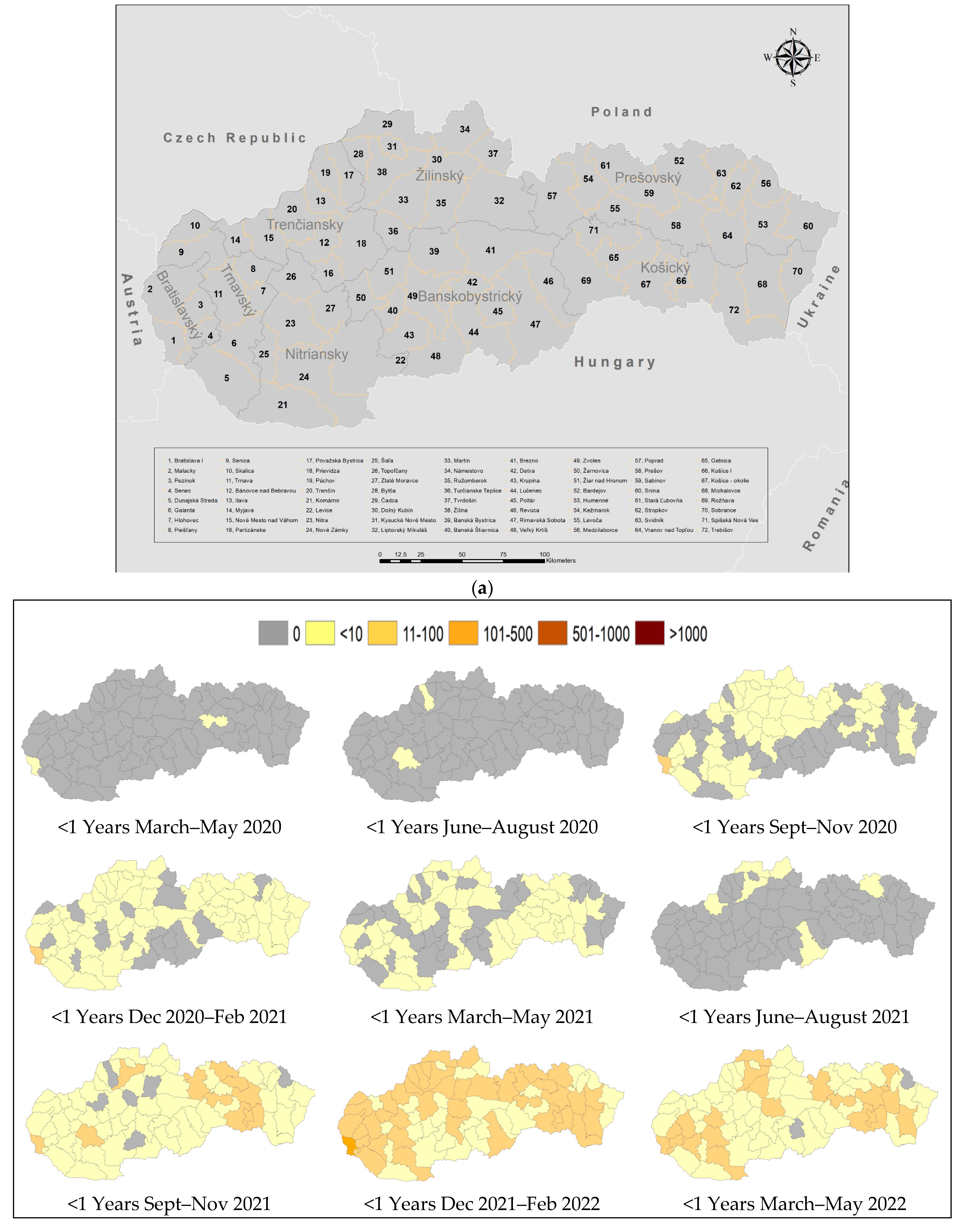
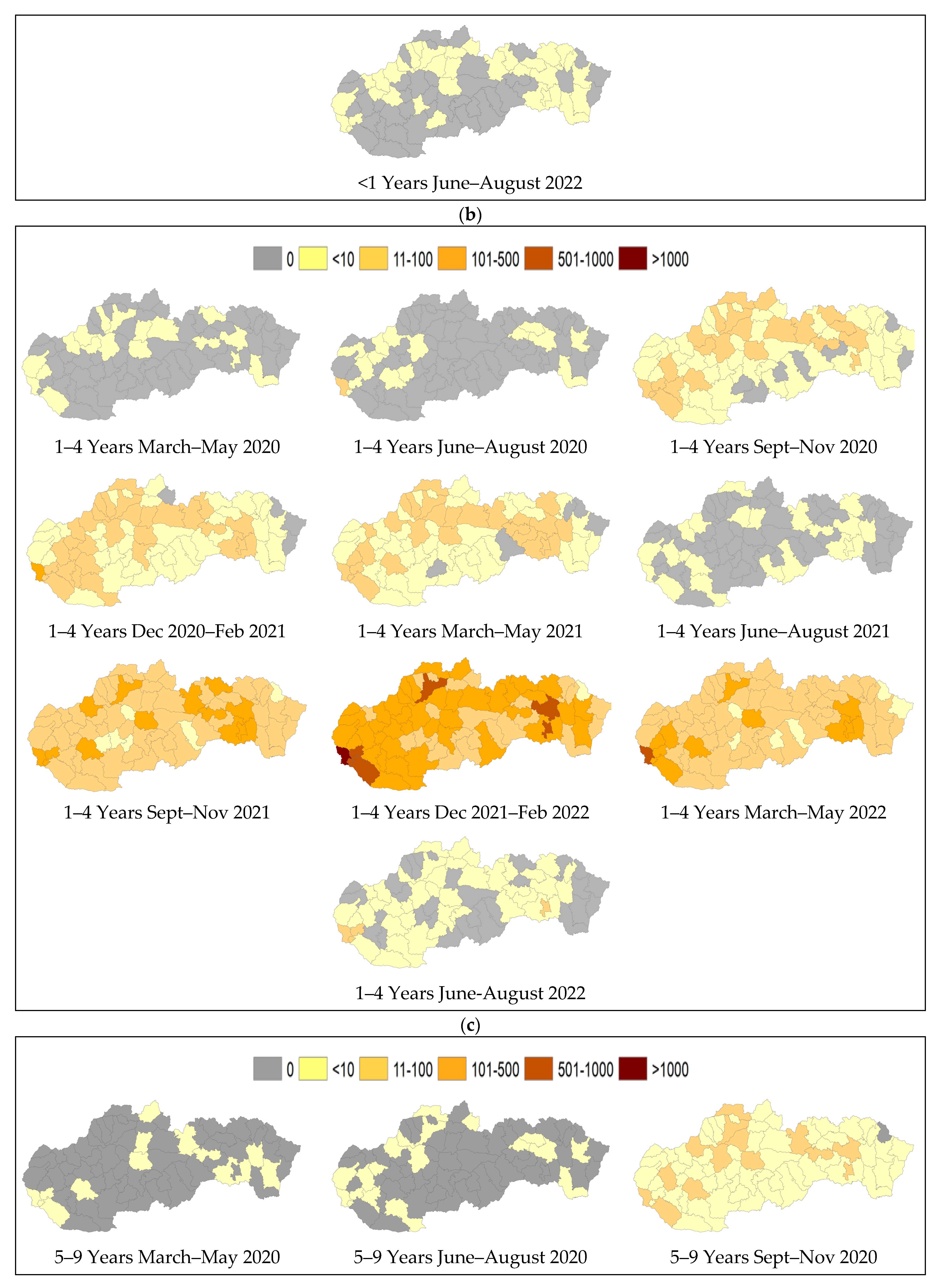
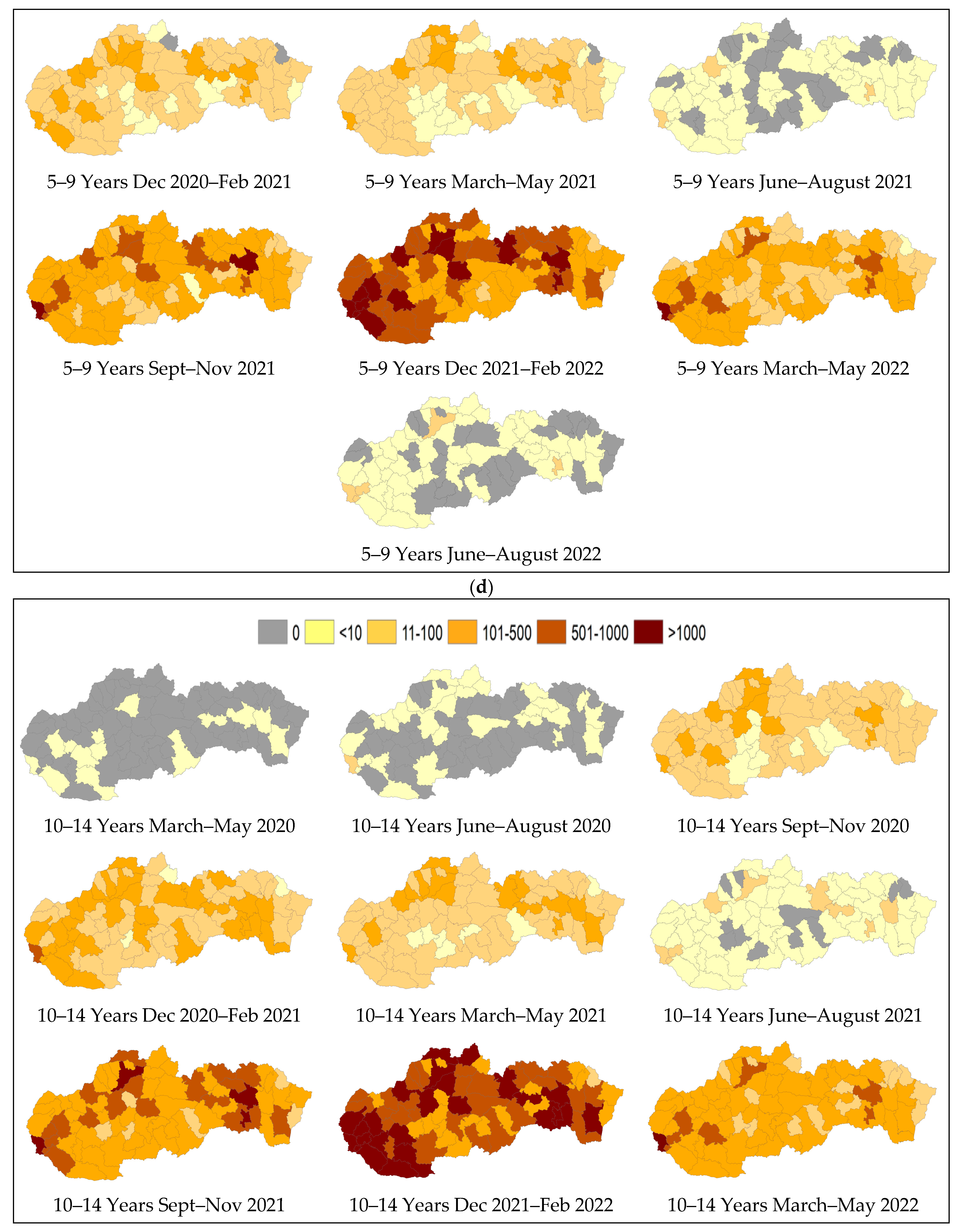
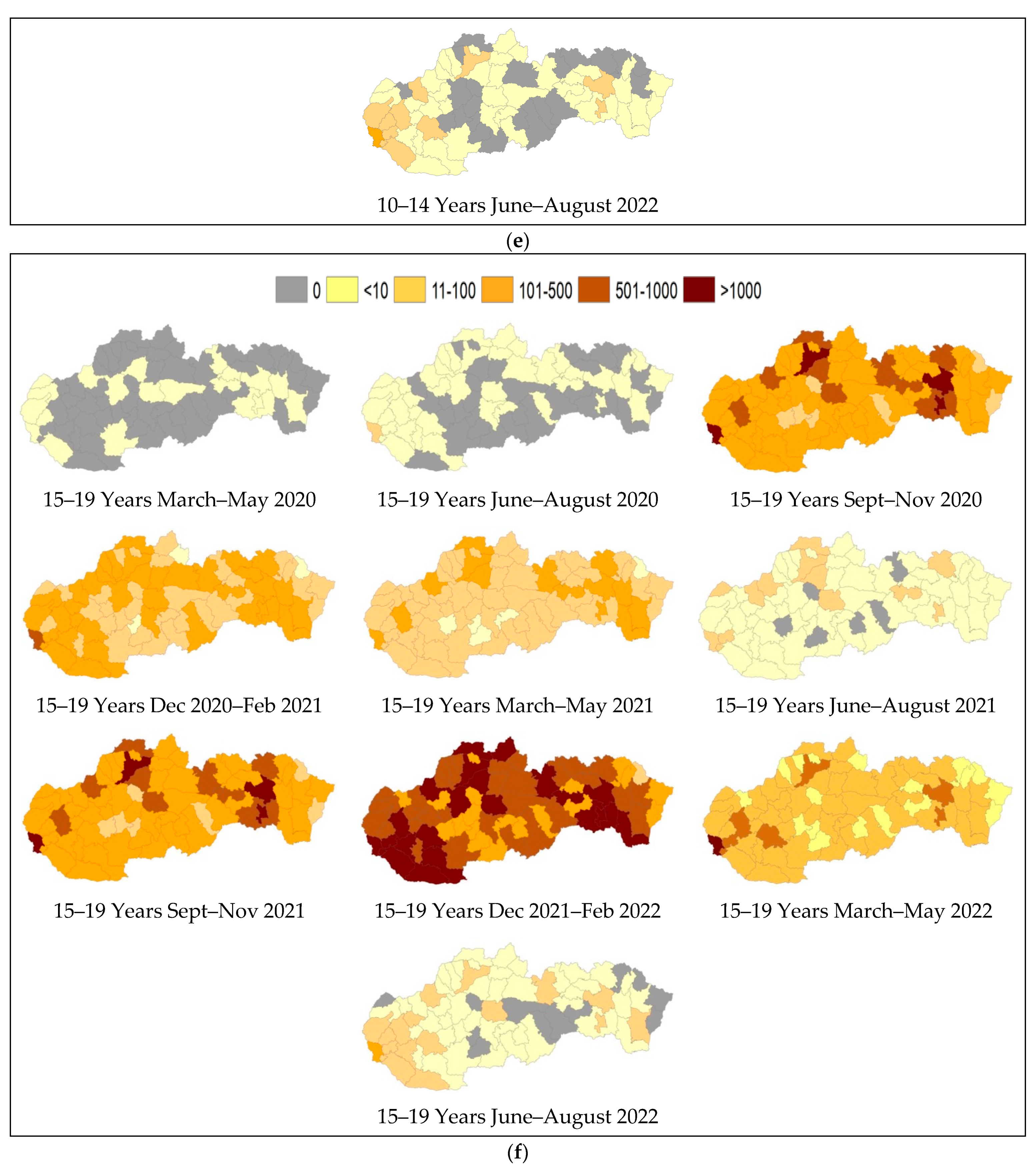
3.2. Spatiotemporal Mapping of COVID Cases

Spatial maps for five age groups were created based on three-month intervals to provide a comprehensive visual representation of the spread of COVID-19 across the country’s districts over a span of two years (Figure 3a). Analyzing the spatial maps over these intervals reveals distinct patterns and trends in the spread of COVID-19. For example, during the early months of the pandemic, maps show few isolated clusters of cases in specific districts, mainly in Bratislava and Košice. These clusters are centered around major urban areas or regions with international travel connections, where the virus was likely introduced. As the pandemic progressed, the virus gradually spread to neighboring districts, both in urban and rural regions, reflecting the movement of infected individuals. Maps also show that the southern districts bordering Hungary have less infected cases (with time) compared to other regions, while regions bordering Czech Republic and Poland have higher cases than other regions. This trend is mainly discernable in the 10–14 and 14–19-year-old age groups.
During the early stages of pandemic, maps of the <1-year-old group show only two districts (district–region) were affected during the first three months (Bratislava IV–Bratislava, Detva–Banská Bystrica) followed by (Bytča–Žilina and Nitra—Nitra). The virus then spread to most (about 70%) of the country’s districts (Sep 2020 to May 2021). Furthermore, during June to August 2021, the spread was only present in six districts, mainly in the northern parts of the country. During December 2021 to February 2022, maps show that the whole country was infected, where the eastern and northern parts of the country and major areas in the western part of the country show 11–100 cases, while the rest show <10 cases per three-month period, and only one district (Braislava IV) shows 101–500 cases (Figure 3b).
For the 1–4-year-old group, similar trends were observed with more areas having higher numbers of infections. Figure 3c shows that the virus spread over the whole country during Sep 2021 to May 2022. During December 2021 to February 2022, maps for the 1–4-year-old group show four districts with 500–1000 cases (Senec, Žilina, Prešov, and Košice) and one with >1000 (Bratislava).
Furthermore, the 5–9, 10–14, and 15–19-year-old age groups (Figure 3d–f) showed more areas with >1000 cases affected by the virus, especially during December 2021 to February 2022. For the 5–9, 10–14, and 15–19-year-old age groups, there were 14, 24, and 22 districts exceeding 1000 cases, and 28, 28, and 31 districts with 501–1000 cases, respectively.

4. Discussion

The selection of pediatric and teenage age groups was due to the comparatively milder impact of the pandemic on children, making it rare to observe fatalities. This choice aims to better grasp the spread of COVID-19 within these age groups/demographics.
The UN Convention on the Rights of the Child in the Slovak Republic defines a child as any individual under the age of 19 years, unless otherwise stipulated by the applicable law. Furthermore, a commonly used categorization for different stages of childhood and adolescence is infants (<1 year), young children (1–4 years), children (5–9 years), pre-adolescents (10–14 years), and adolescents (15–19 years). These age groupings are widely recognized and applied in various fields such as healthcare, education, and developmental psychology.
The spatiotemporal maps of Slovakia across the five age groups offer a revealing insight into the spread of COVID-19 over the study period. The maps, segmented into three-month intervals, demonstrate evolving patterns in the virus transmission. Regular updates every three months allow for the monitoring of infection patterns and trends in different districts; in addition, spatial maps can identify districts with higher or lower cases and the presence of hot spots at specific times.
Initially, during the early stages of the pandemic, isolated clusters of cases were primarily observed in major urban hubs like Bratislava and Košice, likely due to international travel connections [13]. As time progressed, the virus spread to neighboring urban and rural districts, indicating the movement of infected individuals. Notably, the southern districts bordering Hungary showed fewer infections over time compared to regions bordering Czech Republic and Poland; this was particularly evident in the 10–14 and 14–19-year-old age groups. In the <1-year-old group, the initial impacts were limited to a few districts and gradually encompassed approximately 70% of the country’s districts by May 2021. However, a resurgence in infections was evident from June to August 2021, mainly in the northern part of the country. By December 2021 to February 2022, the entire country was affected, with varying intensity across regions. The 1–4-year-old age group exhibited similar trends but with broader geographical coverage and higher infection numbers, including districts with 500–1000 cases and one district with over 1000 cases. Moreover, the 5–9, 10–14, and 15–19-year-old age groups showed widespread infected areas, notably peaking during December 2021 to February 2022, with several districts surpassing 1000 cases and a significant number of districts reporting between 501 and 1000 cases. These findings underscore the varied temporal and spatial dynamics of COVID-19 transmission across different age groups in Slovakia, highlighting the need for targeted intervention strategies and public health measures to mitigate the impact of the pandemic.
The spread of COVID-19 in Slovakia, as depicted in the spatiotemporal maps across different age groups, can be attributed to several factors. Initially, the emergence of isolated clusters in major urban centers such as Bratislava and Košice suggests that the virus was likely introduced through international travel connections, a common pathway for global early infections [13,14]. As the pandemic progressed, factors such as population density, mobility within and between regions, and social interactions likely facilitated the virus’s spread to urban and rural neighboring districts [15]. The observed patterns of infection in districts bordering Hungary, Czech Republic, and Poland could be influenced by cross-border travel and interactions, highlighting the importance of regional dynamics in the virus transmission [16]. Additionally, varying levels of adherence to preventive measures, such as closing preschools, primary and secondary schools, mask-wearing, social distancing, and testing availability, could have impacted infection rates across different areas and age groups. The resurgence of infections in specific regions during certain periods, such as the northern region in mid-2021, may reflect localized outbreaks linked to events or gatherings. Moreover, age-specific behaviors and activities could contribute to the observed differences, with teenage groups possibly engaging in more social interactions and activities, leading to higher infection rates. Overall, the complex interplay of geographic, demographic, behavioral, and preventive factors shapes the spatial and temporal dynamics of COVID-19 transmission in Slovakia, emphasizing the need for tailored interventions and vigilant public health measures to curb the spread of the virus.
According to the available data and research, there are several factors that contribute to the higher COVID-19 infection rates among individuals under the age of 19. (1) Behavioral patterns: teenage individuals generally tend to engage in more social interactions than younger ones, which increases their chances of coming into contact with the virus. This age group may be more likely to disregard preventive measures (e.g., social distancing and mask-wearing) [17,18,19]. (2) School settings: educational institutions, such as schools and colleges, provide an environment where the virus can easily spread among students due to close contact and shared spaces [20]. (3) Asymptomatic cases: younger individuals are more likely to be asymptomatic, meaning they do not exhibit typical COVID-19 symptoms even if they are infected. This makes it harder to identify and isolate cases, leading to further spread within their communities [21].
Therefore, these maps offer valuable insights into the temporal and spatial dynamics of the pandemic, allowing policymakers, healthcare professionals, and the general public to track the progression of the virus and make data-driven decisions. Hotspots, depicted as areas with high infection rates, shift across districts as localized outbreaks occur and are brought under control through targeted measures. These maps also reveal the impact of various factors, such as population density, socioeconomic conditions (urban vs. rural areas), and healthcare infrastructure, on the spread and containment of the virus within different districts [22,23].
By examining the maps over the study period, it becomes evident that the spread of COVID-19 is not uniform throughout the country. Some districts had multiple waves of infections, while others managed to maintain a relatively lower number of cases. This highlights the importance of localized strategies and interventions tailored to specific districts, considering their unique characteristics and vulnerabilities. A detailed spatiotemporal analysis in six periods based on six-month intervals by [12] using the spatial autocorrelation of COVID-19 in Slovakia showed that the spatial distribution of COVID-19 in Slovakia is heterogeneous, and cases were concentrated in all regions depending on the period in which they were monitored. In addition, their research suggested that geographic and temporal analyses will be very important in the future.
A study conducted on eight age groups (<20, 20–29, 30–39, …, and >80 years) revealed that neighborhood socioeconomic status was a more significant risk factor for COVID-19 incidence in children and working-age adults compared to seniors [24]. Social demographics and housing conditions were important risk factors for COVID-19 incidence in older age groups. Additionally, transportation-related variables showed significant associations with COVID-19 incidences across multiple age groups. The study concluded that age played a role in modifying the relationship between neighborhood characteristics and COVID-19 incidence.
A geographic information system (GIS) modeling approach was employed to pinpoint the risk factors influencing COVID-19 incidence rates at the district level. The model outcomes indicated that urban population and proximity to the capital city were significant factors contributing to the COVID-19 incidence rates in Bangladesh. Moreover, the study revealed that urban areas exhibited a higher prevalence of COVID-19 infections compared to rural areas [25].
Demographic studies provide a good understanding of the spread and fatality rates of COVID-19. Several demographic factors contribute to the age-specific infection rates. The main factor is likely to be age itself. Older individuals tend to have a higher risk of contracting the virus due to their weakened immune system and preexisting health conditions (e.g., heart disease, diabetes, or respiratory issues). Other demographic factors, such as healthcare workers or professions that require close contact with others, may increase the risk of exposure to the virus. In addition, living conditions and socioeconomic factors can also impact the likelihood of infection, as individuals in crowded households or low-income communities may have limited access to preventive measures like social distancing or healthcare [26].
A study explored the spatial association between socio-demographic factors and COVID-19 outcomes across Europe [27]. In Slovakia, this study showed moderate associations between socio-demographic variables (such as income and poverty) and COVID-19 cases and deaths. This suggests that factors like total population, poverty, and income play a significant role in regulating COVID-19 casualties. The analysis also indicated heterogeneous distributions of cases and deaths across Europe, with Western European countries showing higher actual values. The study underlined the importance of considering infection rates and recovery rates for a more accurate interpretation of COVID-19 impacts. Additionally, spatial regression models highlighted a strong positive association between income, total population, and COVID-19 cases and deaths in European countries, suggesting these as key controlling variables for pandemic outcomes.
In the context of Slovakia, exploring the spatial association between socio-demographic factors and COVID-19 outcomes can provide valuable insights into the potential drivers of transmission and the severity of the disease. By analyzing the geographic distribution of COVID-19 cases, we can identify areas with higher incidence rates and investigate the socio-demographic characteristics that may be associated with these hotspots. This information can help policymakers and health authorities tailor their response efforts to target vulnerable populations and mitigate the further spread of the virus.
Furthermore, the policy of admitting children and adolescents to the hospital in general is easy to uphold, especially during the pandemic in Slovakia; even so, all the admitted cases had symptoms of respiratory infection or gastrointestinal acute disorders like diarrhea and vomiting. Otherwise, the referral of severe COVID-19 cases from small, rural hospitals to large children’s hospitals was common; that is why the number of intensive care unit admissions and patients receiving pulmonary ventilation in large teaching children’s hospitals significantly increased in comparison to those in smaller hospitals (See Table A3, Appendix A), like hospitals in Nitra, Košice, and Bratislava.
The spatial maps offer a crucial retrospective tool for assessing intervention effectiveness in districts during the COVID-19 pandemic. Policymakers can correlate intervention timing with map patterns to identify successful containment measures and areas needing further attention [23]. However, these maps rely on evolving data sources, which are potentially affected by testing capacity and reporting discrepancies among districts, impacting data reliability. This underscores the need for comprehensive data for decision-making. Disparities in testing access can lead to varying case reports, affecting our grasp of the virus’s spread. To enhance understanding, these maps should be used alongside other data and local knowledge. Overall, these maps aid in monitoring, analyzing, and responding to COVID-19, and guiding targeted interventions and resource allocation to safeguard public health [28,29].
This study presented a comprehensive analysis of the spatiotemporal patterns of COVID-19 infections across five ≤19-year-old age groups in 72 districts of Slovakia from March 2020 to July 2022. The findings highlight the significant impact of the pandemic on the country and provide valuable insights for understanding the disease’s dynamics.
One limitation of this study is the potential concern arising from the substantial loss of outpatient data, especially for patients recruited from hospital settings, which could result in selection bias and affect the validity of the study’s findings; however, in this case, the available data were only analyzed for registered cases.

5. Conclusions

Spatial mapping showed high-risk infection clusters mainly in urban areas with gradual spread to neighboring districts. The highest infections were associated with pre-adolescent and adolescent groups. The study highlighted the impact of population density and socioeconomic conditions on the spread and containment of the virus. These insights are vital for targeted public health strategies and resource allocation.

Author Contributions

Conceptualization, A.G. and M.A.G.; methodology, A.G., M.A.G. and S.B.; software, M.A.G. and S.B.; validation, M.A.G. and S.B.; formal analysis, A.G., M.A.G. and S.B.; investigation, A.G. and M.A.G.; resources, A.G.; data curation, A.G. and M.A.G.; writing—original draft preparation, A.G., A.M.K. and M.A.G.; writing—review and editing, A.G., A.M.K. and M.A.G.; visualization, A.G. and M.A.G.; supervision, M.A.G.; project administration, A.G. All authors have read and agreed to the published version of the manuscript.

Funding

This research received no external funding.

Institutional Review Board Statement

The study was conducted according to the guidelines of the Declaration of Helsinki. Requested the information be made available on the basis of § 15 par. 1 of Act no. 211/2000 Coll. on free access to information, approved by 1 August 2022.

Informed Consent Statement

Informed consent was obtained from the National Health Information Centre (NCZI), the Ministry of Health of the Slovak Republic.

Data Availability Statement

Original and generated data for study are available from A.G. on reasonable request.

Acknowledgments

The authors acknowledge the National Health Information Centre (Národné centrum zdravotníckych informácií, NCZI), the Ministry of Health of the Slovak Republic for providing the data used in this study.

Conflicts of Interest

The authors declare no conflicts of interest.

Appendix A

Table A1. Total PCR cases in different age groups, case per population, and case per area (km2) of all regions and districts of Slovakia.
Age Group (Year)
Region/District<11–45–910–1415–19TotalPopArea km2Case/Pop %Case/km2
Banská Bystrica2262377853913,03712,80636,985643,10294505.83.91
Banská Bystrica476722287325228379095110,6318098.211.24
Banská Štiavnica86921033630092316,0032925.83.16
Brezno818067911141123310460,90512655.12.45
Detva15151548715776220531,7714496.94.91
Krupina996279434505132322,0505846.02.27
Lučenec1614975712891220343173,0718254.74.16
Poltár34618734237795521,1794764.52.01
Revúca864255475588139039,3497303.51.90
Rimavská Sobota2420881413511365376283,95314714.52.56
Veľký Krtíš1591408681776197143,0028484.62.32
Žarnovica1481266392375112826,0544254.32.65
Žiar nad Hronom18196664923942274346,4775175.95.31
Zvolen41374118517331622495568,6577597.26.53
Bratislava422515017,31420,71615,03358,635677,02420488.728.63
Bratislava276313210,33812,084879434,624440,9483657.994.86
Malacky30312142922111713569575,3259497.66.00
Pezinok36545193724521806677666,17437510.218.07
Senec80116136103969272011,54094,57735912.232.14
Košice402353211,77017,54316,58049,827802,09267496.27.38
Gelnica1792360485479143331,9235844.52.45
Košice145148244236034540717,491238,1382417.372.58
Košice—okolie696341894287826818156131,30515346.25.32
Michalovce503601376211920435948110,67010195.45.84
Rožňava1414565311401066301861,94411734.92.57
Sobrance76318833639498822,7755384.31.84
Spišská Nová Ves625411930253222167281100,2015877.312.40
Trebišov38215946201922945512105,13610735.25.14
Nitra2602348870713,26212,54937,126671,50863415.55.85
Komárno232341121190616974981100,99211004.94.53
Levice24215904154115304214110,04015513.82.72
Nitra10292531404096377712,040161,4998707.513.84
Nové Zámky523601337212120975967137,77813474.34.43
Šaľa1424581711701050329651,3093556.49.28
Topoľčany3526899717681749481769,5215976.98.07
Zlaté Moravce10101391660649181140,3695214.53.48
Prešov511433015,16021,69320,68362,377827,02889657.56.96
Bardejov38314124620162198581277,6669357.56.22
Humenné4522076312451268354161,3987545.84.70
Kežmarok28265102115881431433376,1656295.76.89
Levoča14200580856854250433,7304217.45.95
Medzilaborce317478714029411,7084272.50.69
Poprad565882237294025678388105,01511048.07.60
Prešov132132342815300483815,874176,7819339.017.01
Sabinov43401132817401542505461,0725458.39.27
Snina1489356659741185935,8338045.22.31
Stará Ľubovňa39362131718881694530054,0547079.87.50
Stropkov19103407609556169420,3663888.34.37
Svidník22130548917875249232,3345497.74.54
Vranov nad Topľou58318102918481979523280,9067696.56.80
Trenčín252296911,25015,73514,44244,648582,56744977.79.93
Bánovce nad Bebravou72048471105983314635,9724618.76.82
Ilava27233106415561380426058,8113587.211.90
Myjava11181624781652224926,0623278.66.88
Nové Mesto nad Váhom36370135218521585519562,5725798.38.97
Partizánske14186630946928270445,2933016.08.98
Považská Bystrica32432136318741787548861,9934638.911.85
Prievidza453891453258926037079132,8919595.37.38
Púchov3423994912681284377444,1363758.610.06
Trenčín4673529683764324010,753114,8376749.415.95
Trnava282320712,20015,92713,85445,470565,32441448.010.97
Dunajská Streda498182818353626429863123,35510748.09.18
Galanta41385171222712114652394,1796416.910.18
Hlohovec2424298412901199373944,7312678.414.00
Piešťany47448138117831630528962,6263818.413.88
Senica30324111416281516461260,3146837.66.75
Skalica20238106114471301406746,9653578.711.39
Trnava7175231303972345211,377133,1547418.515.35
Žilina464394214,06020,07619,81958,361691,13668028.48.58
Bytča28141556861898248431,0562818.08.84
Čadca45361146022982716688089,4947607.79.05
Dolný Kubín331726831016995289939,4804917.35.90
Kysucké Nové Mesto18105475855865231832,8901737.013.40
Liptovský Mikuláš21389124418241756523472,05413417.33.90
Martin55611232629462708864695,9217359.011.76
Námestovo50291117119541950541663,2686908.67.85
Ružomberok32298102214871489432856,5366467.76.70
Turčianske Teplice468286367361108615,8543926.92.77
Tvrdošín211425148751003255536,1274787.15.35
Žilina157136443235593507816,515158,45681510.420.26
Grand Total281927,85599,000137,989125,766393,4295,459,78148,9967.28.3
Values in bold indicate total cases in region.
Table A2. Total hospitalization cases in different age groups, case per population, and case per area (km2) of all regions and districts of Slovakia.
Age Group (Year)
Region/District<11–45–910–1415–19TotalpopArea km2Case/Pop %Case/km2
Banská Bystrica2542291462124521293643,10294500.200.14
Banská Bystrica206193128181170878110,6318090.791.09
Brezno152 4194060,90512650.070.03
Lučenec 363673,0718250.050.04
Revúca 8852139,3497300.050.03
Rimavská Sobota 5583,95314710.010.00
Veľký Krtíš1 341943,0028480.020.01
Žiar nad Hronom 32820421746,4775170.470.42
Zvolen323157128768,6577590.130.11
Bratislava74610414654416163309677,02420480.491.62
Bratislava74610414654415853278440,9483650.748.98
Pezinok 313166,1743750.050.08
Košice122710113705149384060802,09267490.510.60
Košice879785306410662304231,9235849.535.21
Michalovce513 40103161110,67010190.150.16
Rožňava31675257461,94411730.120.06
Spišská Nová Ves224136312693510100,2015870.510.87
Trebišov8871263355273105,13610730.260.25
Nitra2443242103742193081671,50863410.460.49
Komárno10243211541222100,99211000.220.20
Levice6713117651272110,04015510.250.18
Nitra2210194226632360161,4998701.462.71
Nové Zámky 88137,77813470.010.01
Topoľčany644923275621969,5215970.320.37
Prešov117577630569611704122827,02889650.500.46
Bardejov477211289325177,6669350.320.27
Humenné130341533221461,3987540.350.28
Kežmarok3726 184412576,1656290.160.20
Levoča 3333,7304210.010.01
Poprad172207130145185839105,01511040.800.76
Prešov4822511404577172047176,7819331.162.19
Snina35163232610361,0725450.170.19
Stará Ľubovňa2521165125844335,8338041.240.55
Svidník2054110129732,3345490.300.18
Trenčín1711564170416854582,56744970.150.19
Myjava6834284926,0623270.190.15
Partizánske 4445,2933010.010.01
Považská Bystrica5030 5913961,9934630.220.30
Prievidza455378104217132,8919590.160.23
Trenčín70653158221445114,8376740.390.66
Trnava1541715767126575565,32441440.100.14
Dunajská Streda 7 31323123,35510740.020.02
Galanta 1111183194,1796410.030.05
Piešťany483819393117562,6263810.280.46
Skalica 11 61746,9653570.040.05
Trnava106114371458329133,1547410.250.44
Žilina235575992194641592691,13668020.230.23
Čadca59442096519789,4947600.220.26
Dolný Kubín65796332620939,4804910.530.43
Liptovský Mikuláš70905153221272,05413410.290.16
Martin232383814825069795,9217350.730.95
Ružomberok 3 5283656,5366460.060.06
Tvrdošín181213093721536,1274780.600.45
Žilina 2626158,4568150.020.03
Grand Total6405420115862293440118,8865,459,78148,9960.350.39
Values in bold indicate total cases in region.
Table A3. Total intensive care unit admissions in different age groups in all regions and districts of Slovakia.
Age Group (Year)
Region/District<11–45–910–1415–19Total
Banská Bystrica90136432
Banská Bystrica9 136 28
Lučenec 44
Bratislava230392416102
Košice2320192733122
Košice14197271885
Michalovce 88
Spišská Nová Ves9112 22
Trebišov 77
Nitra14000216158
Komárno 1010
Levice 246
Nitra140 140
Topoľčany 22
Prešov0001910
Bardejov 44
Humenné 1 1
Stará Ľubovňa 55
Trenčín 11
Myjava 11
Žilina00003131
Martin 2020
Tvrdošín 1111
Grand Total195207160110456
Values in bold indicate total cases in region.
Table A4. Total pulmonary ventilation admissions in different age groups in all regions and districts of Slovakia.
Age Group (Year)
Region/District<11–45–910–1415–19Total
Banská Bystrica 2 13
Banská Bystrica 2 2
Revúca 11
Bratislava1 3810655
Bratislava1 3810655
Košice121914325100
Košice1119 431891
Spišská Nová Ves1 1 2
Trebišov 77
Nitra140 10150
Komárno 66
Levice 44
Nitra140 140
Prešov9 817
Bardejov 11
Humenné2 2
Poprad7 7
Snina 77
Trenčín 1212
Myjava 11
Považská Bystrica 33
Trenčín 88
Žilina 462268
Čadca 33
Martin 461763
Tvrdošín 11
Žilina 11
Grand Total16221399984405
Values in bold indicate total cases in region.

References

  1. Kang, D.; Choi, H.; Kim, J.-H.; Choi, J. Spatial epidemic dynamics of the COVID-19 outbreak in China. Int. J. Infect. Dis. 2020, 94, 96–102. [Google Scholar] [CrossRef]
  2. Stoecklin, S.B.; Rolland, P.; Silue, Y.; Mailles, A.; Campese, C.; Simondon, A.; Mechain, M.; Meurice, L.; Nguyen, M.; Bassi, C.; et al. First cases of coronavirus disease 2019 (COVID-19) in France: Surveillance, investigations and control measures, January 2020. Eurosurveillance 2020, 25, 2000094. [Google Scholar] [CrossRef]
  3. IHME-Institute for Health Metrics and Evaluation. COVID-19 Resources. 2022. Available online: http://www.healthdata.org/covid (accessed on 1 January 2022).
  4. WHO. WHO Coronavirus (COVID-19) Dashboard; World Health Organization: Geneva, Switzerland, 2023. [Google Scholar]
  5. González-Candelas, F.; Shaw, M.-A.; Phan, T.; Kulkarni-Kale, U.; Paraskevis, D.; Luciani, F.; Kimura, H.; Sironi, M. One year into the pandemic: Short-term evolution of SARS-CoV-2 and emergence of new lineages. Infect. Genet. Evol. 2021, 92, 104869. [Google Scholar] [CrossRef]
  6. B.1.258∆, a SARS-CoV-2 Variant with ∆H69/∆V70 in the Spike Protein Circulating in the Czech Republic and Slovakia-SARS-CoV-2 coronavirus/nCoV-2019 Genomic Epidemiology-Virological. (n.d.). Available online: https://virological.org/t/b-1-258-a-sars-cov-2-variant-with-h69-v70-in-the-spike-protein-circulating-in-the-czech-republic-and-slovakia/613 (accessed on 9 May 2024).
  7. De Angelis, M.; Durastanti, C.; Giovannoni, M.; Moretti, L. Spatio-temporal distribution pattern of COVID-19 in the Northern Italy during the first-wave scenario: The role of the highway network. Transp. Res. Interdiscip. Perspect. 2022, 15, 100646. [Google Scholar] [CrossRef] [PubMed]
  8. Grimée, M.; Dunbar, M.B.-N.; Hofmann, F.; Held, L. Modelling the effect of a border closure between Switzerland and Italy on the spatiotemporal spread of COVID-19 in Switzerland. Spat. Stat. 2022, 49, 100552. [Google Scholar] [CrossRef] [PubMed]
  9. Aisyah, D.N.; Mayadewi, C.A.; Diva, H.; Kozlakidis, Z.; Siswanto; Adisasmito, W. A spatial-temporal description of the SARS-CoV-2 infections in Indonesia during the first six months of outbreak. PLoS ONE 2020, 15, e0243703. [Google Scholar] [CrossRef]
  10. Kianfar, N.; Mesgari, M.S. GIS-based spatio-temporal analysis and modeling of COVID-19 incidence rates in Europe. Spat. Spatio-Temporal Epidemiology 2022, 41, 100498. [Google Scholar] [CrossRef]
  11. de Souza, A.P.G.; Mota, C.M.d.M.; Rosa, A.G.F.; de Figueiredo, C.J.J.; Candeias, A.L.B. A spatial-temporal analysis at the early stages of the COVID-19 pandemic and its determinants: The case of Recife neighborhoods, Brazil. PLoS ONE 2022, 17, e0268538. [Google Scholar] [CrossRef] [PubMed]
  12. Vilinová, K.; Petrikovičová, L. Spatial Autocorrelation of COVID-19 in Slovakia. Trop. Med. Infect. Dis. 2023, 8, 298. [Google Scholar] [CrossRef]
  13. Jamal, S.; Paez, A. Socio-economic and demographic differences in the impact of COVID-19 on personal travel in the Global South. Transp. Rev. 2024, 44, 272–298. [Google Scholar] [CrossRef]
  14. Zoungrana, T.D.; Yerbanga, A.; Ouoba, Y. Socio-economic and environmental factors in the global spread of COVID-19 outbreak. Res. Econ. 2022, 76, 325–344. [Google Scholar] [CrossRef] [PubMed]
  15. Kwok, C.Y.T.; Wong, M.S.; Chan, K.L.; Kwan, M.-P.; Nichol, J.E.; Liu, C.H.; Wong, J.Y.H.; Wai, A.K.C.; Chan, L.W.C.; Xu, Y.; et al. Spatial analysis of the impact of urban geometry and socio-demographic characteristics on COVID-19, a study in Hong Kong. Sci. Total. Environ. 2021, 764, 144455. [Google Scholar] [CrossRef] [PubMed]
  16. Vega-Gonzalo, M.; Gomez, J.; Christidis, P. How has COVID-19 changed private car use in European urban areas? An analysis of the effect of socio-economic characteristics and mobility habits. Transp. Res. Part A Policy Pract. 2023, 172, 103679. [Google Scholar] [CrossRef] [PubMed]
  17. Irawan, M.Z.; Rizki, M.; Joewono, T.B.; Belgiawan, P.F. Exploring the intention of out-of-home activities participation during new normal conditions in Indonesian cities. Transp. Res. Interdiscip. Perspect. 2020, 8, 100237. [Google Scholar] [CrossRef] [PubMed]
  18. Kim, J.K.; Crimmins, E.M. How does age affect personal and social reactions to COVID-19: Results from the national Understanding America Study. PLoS ONE 2020, 15, e0241950. [Google Scholar] [CrossRef] [PubMed]
  19. Chen, T.; Lucock, M. The mental health of university students during the COVID-19 pandemic: An online survey in the UK. PLoS ONE 2022, 17, e0262562. [Google Scholar] [CrossRef] [PubMed]
  20. Magson, N.R.; Freeman, J.Y.A.; Rapee, R.M.; Richardson, C.E.; Oar, E.L.; Fardouly, J. Risk and Protective Factors for Prospective Changes in Adolescent Mental Health during the COVID-19 Pandemic. J. Youth Adolesc. 2021, 50, 44–57. [Google Scholar] [CrossRef] [PubMed]
  21. Snape, M.D.; Viner, R.M. COVID-19 in children and young people. Science 2020, 370, 286–288. [Google Scholar] [CrossRef] [PubMed]
  22. Andrews, M.R.; Tamura, K.; Best, J.N.; Ceasar, J.N.; Batey, K.G.; Kearse, T.A.; Allen, L.V.; Baumer, Y.; Collins, B.S.; Mitchell, V.M.; et al. Spatial Clustering of County-Level COVID-19 Rates in the U.S. Int. J. Environ. Res. Public Health 2021, 18, 12170. [Google Scholar] [CrossRef]
  23. Ficetola, G.F.; Rubolini, D. Containment measures limit environmental effects on COVID-19 early outbreak dynamics. Sci. Total. Environ. 2021, 761, 144432. [Google Scholar] [CrossRef]
  24. Zhang, X.; Smith, N.; Spear, E.; Stroustrup, A. Neighborhood characteristics associated with COVID-19 burden-the modifying effect of age. J. Expo. Sci. Environ. Epidemiology 2021, 31, 525–537. [Google Scholar] [CrossRef] [PubMed]
  25. Rahman, H.; Zafri, N.M.; Ashik, F.R.; Waliullah; Khan, A. Identification of risk factors contributing to COVID-19 incidence rates in Bangladesh: A GIS-based spatial modeling approach. Heliyon 2021, 7, e06260. [Google Scholar] [CrossRef] [PubMed]
  26. Dowd, J.B.; Andriano, L.; Brazel, D.M.; Rotondi, V.; Block, P.; Ding, X.; Liu, Y.; Mills, M.C. Demographic science aids in understanding the spread and fatality rates of COVID-19. Proc. Natl. Acad. Sci. USA 2020, 117, 9696–9698. [Google Scholar] [CrossRef] [PubMed]
  27. Sannigrahi, S.; Pilla, F.; Basu, B.; Basu, A.S.; Molter, A. Examining the association between socio-demographic composition and COVID-19 fatalities in the European region using spatial regression approach. Sustain. Cities Soc. 2020, 62, 102418. [Google Scholar] [CrossRef] [PubMed]
  28. Olds, P.K.; Musinguzi, N.; Geisler, B.P.; Haberer, J.E. Evaluating disparities by social determinants in hospital admission decisions for patients with COVID-19 quaternary hospital early in the pandemic. Medicine 2023, 102, e33178. [Google Scholar] [CrossRef]
  29. Assefa, Y.; Gilks, C.F.; Reid, S.; van de Pas, R.; Gete, D.G.; Van Damme, W. Analysis of the COVID-19 pandemic: Lessons towards a more effective response to public health emergencies. Glob. Health 2022, 18, 10. [Google Scholar] [CrossRef]
Figure 1. Evolution of daily PCR-confirmed COVID-19 cases in Slovakia during 12 March 2020 to 20 July 2022.
Medicina 60 00931 g001
Figure 2. (a) Total positive monthly PCR cases in Slovakia during 2020. (b) Total positive monthly PCR cases in Slovakia during 2021. (c) Total positive monthly PCR cases in Slovakia during 2022.
Medicina 60 00931 g002aMedicina 60 00931 g002b
Figure 3. (a) Districts of Slovakia. (b) Spatiotemporal spread of positive PCR COVID-19 cases in the <1-year-old group based on three-month intervals in Slovakia. (c) Spatiotemporal spread of positive PCR COVID-19 cases in the 1–4-year-old group based on three-month intervals in Slovakia. (d) Spatiotemporal spread of positive PCR COVID-19 cases in the 5–9-year-old group based on three-month intervals in Slovakia. (e) Spatiotemporal spread of positive PCR COVID-19 cases in the 10–14-year-old group based on three-month intervals in Slovakia. (f) Spatiotemporal spread of positive PCR COVID-19 cases in the 15–19-year-old group based on three-month intervals in Slovakia.
Medicina 60 00931 g003aMedicina 60 00931 g003bMedicina 60 00931 g003cMedicina 60 00931 g003d
Table 1. Case per population and case per area (km2) of all regions of Slovakia.
RegionCase/Pop %Case/km2
Banská Bystrica5.83.91
Bratislava8.728.63
Košice6.27.38
Nitra5.55.85
Prešov7.56.96
Trenčín7.79.93
Trnava810.97
Žilina8.48.58
Disclaimer/Publisher’s Note: The statements, opinions and data contained in all publications are solely those of the individual author(s) and contributor(s) and not of MDPI and/or the editor(s). MDPI and/or the editor(s) disclaim responsibility for any injury to people or property resulting from any ideas, methods, instructions or products referred to in the content.

