Geospatial Analysis of Mass-Wasting Susceptibility of Four Small Catchments in Mountainous Area of Miyun County, Beijing


Abstract
:1. Introduction
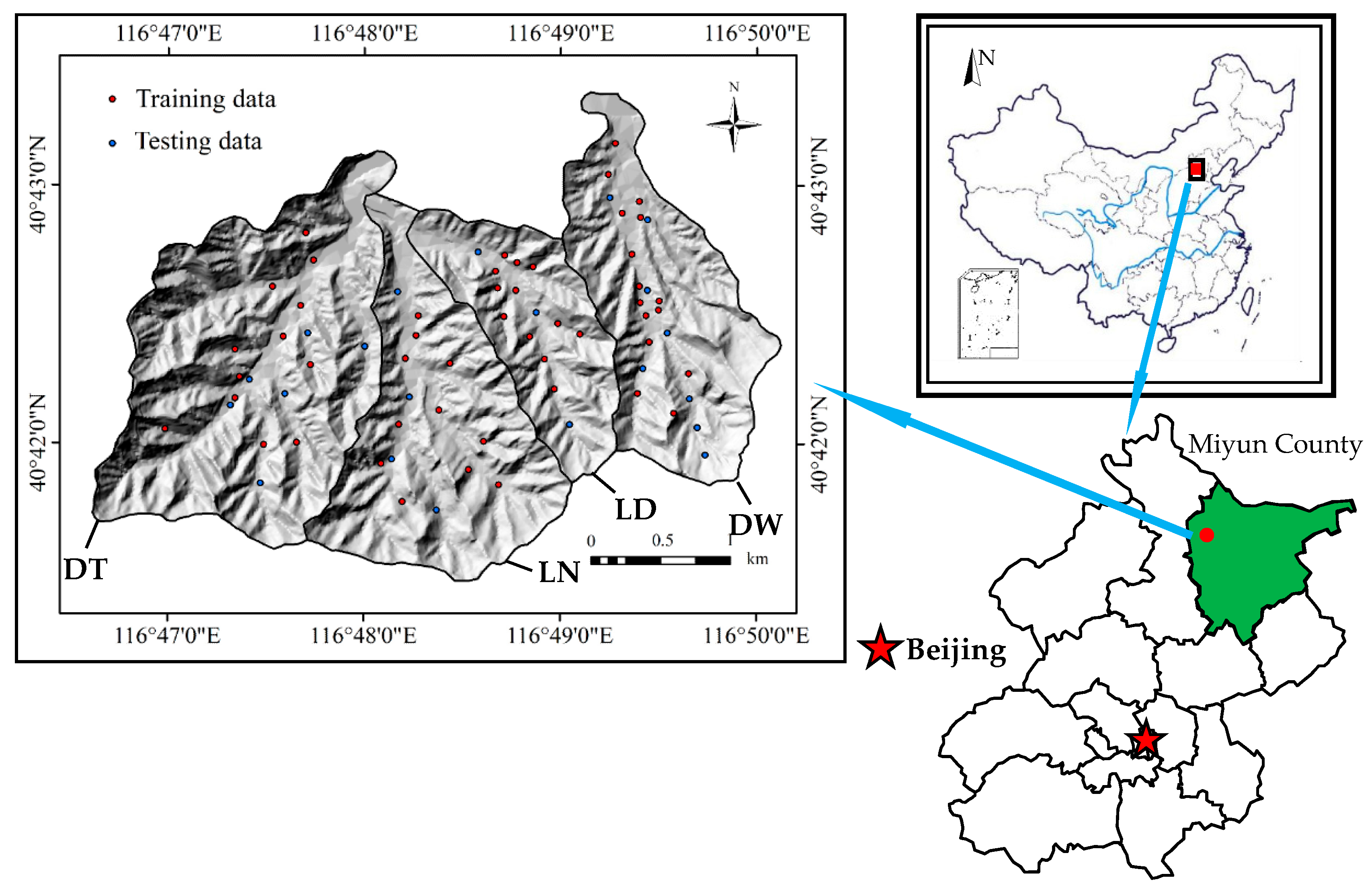
2. Study area and Inventory Maps
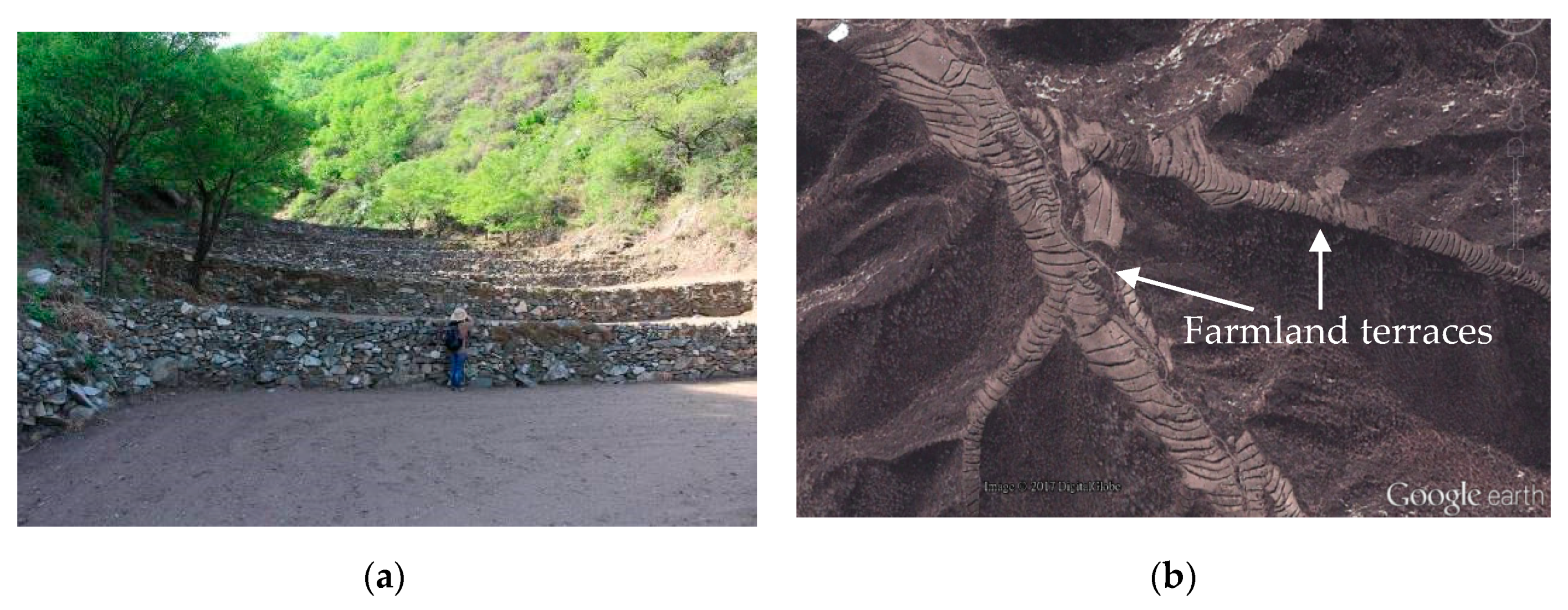
2.1. Identifying Locations of Mass-Wasting Inventory
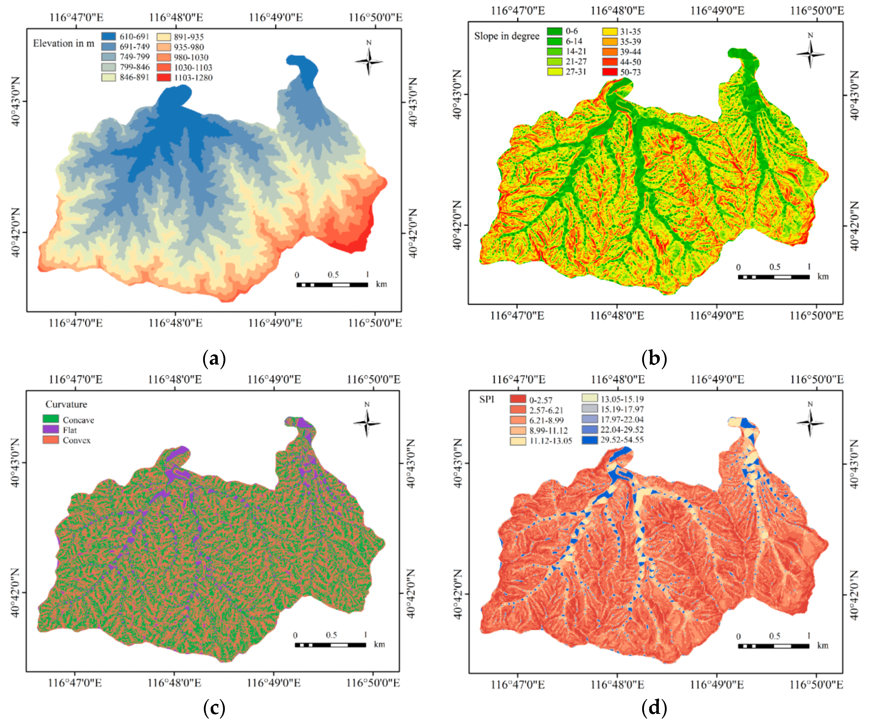
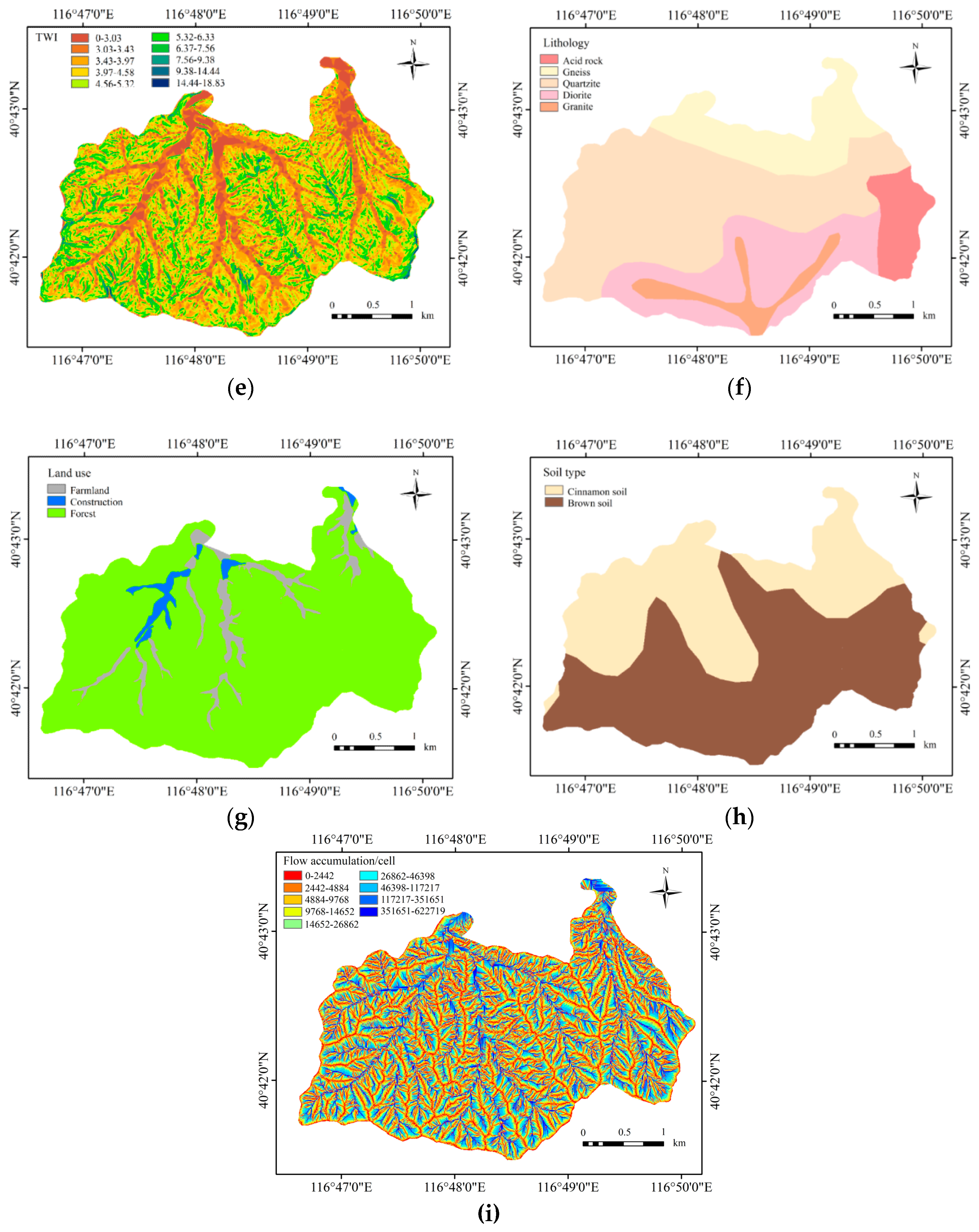
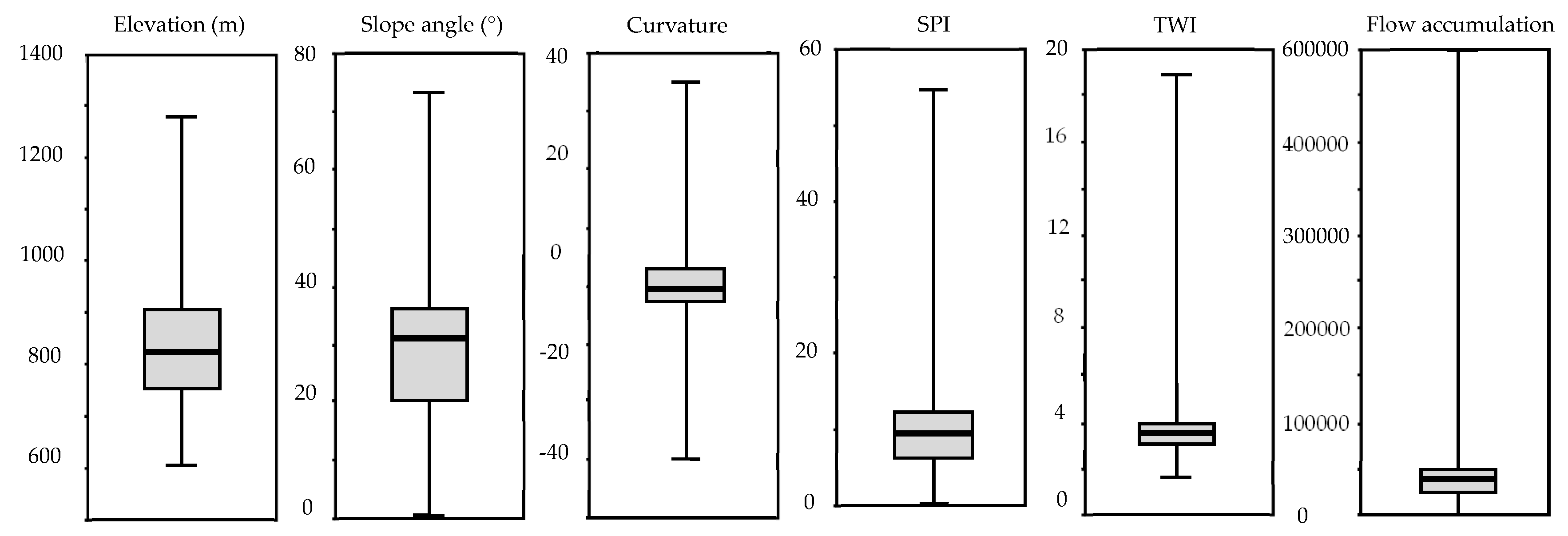
2.2. Influence Factors
3. Methodology
3.1. Frequency Ratio
3.2. Information Value Model
4. Results
4.1. Mass-Wasting Susceptibility Mapping Using the FR Model
4.2. Mass-Wasting Susceptibility Mapping Using the IV Model
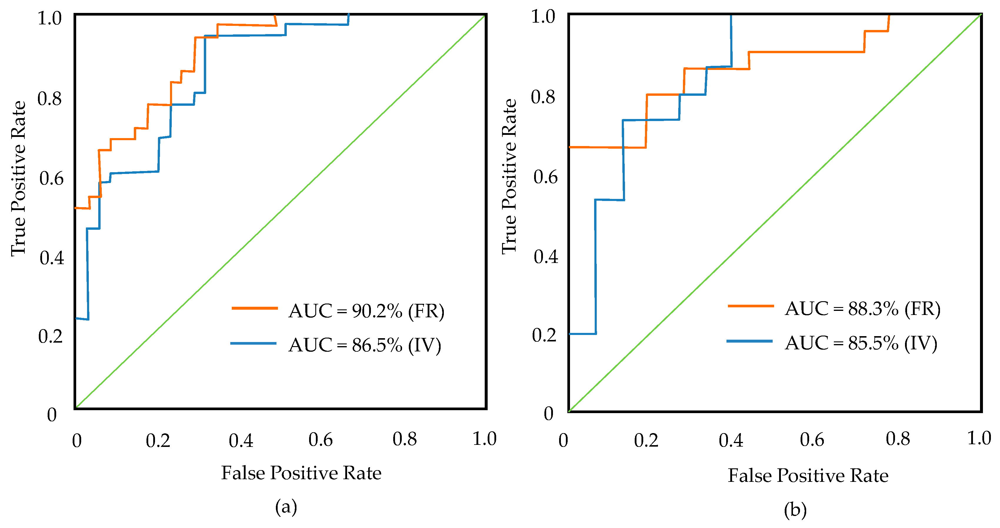
4.3. Validation of Mass-Wasting Susceptibility Mapping
5. Discussion
6. Conclusions
Author Contributions
Funding
Acknowledgments
Conflicts of Interest
References
- Larsen, M.C.; Parks, J.E. How wide is a road? The association of roads and mass-wasting in a forested montane environment. Earth Surf. Process. Landf. J. Br. Geomorphol. Group 1997, 22, 835–848. [Google Scholar] [CrossRef]
- Moernaut, J.; De Batist, M.; Charlet, F.; Heirman, K.; Chapron, E.; Pino, M.; Brümmer, R.; Urrutia, R. Giant earthquakes in South-Central Chile revealed by Holocene mass-wasting events in Lake Puyehue. Sediment. Geol. 2007, 195, 239–256. [Google Scholar] [CrossRef]
- Sarhadi, A.; Soltani, S.; Modarres, R. Probabilistic flood inundation mapping of ungauged rivers: Linking GIS techniques and frequency analysis. J. Hydrol. 2012, 458, 68–86. [Google Scholar] [CrossRef]
- El Morjani, Z.E.A.; Ebener, S.; Boos, J.; Ghaffar, E.A.; Musani, A. Modelling the spatial distribution of five natural hazards in the context of the WHO/EMRO Atlas of Disaster Risk as a step towards the reduction of the health impact related to disasters. Int. J. Health Geogr. 2007, 6, 8. [Google Scholar] [CrossRef] [PubMed]
- Zinck, J.A.; López, J.; Metternicht, G.I.; Shrestha, D.P.; Vázquez-Selem, L. Mapping and modelling mass movements and gullies in mountainous areas using remote sensing and GIS techniques. Int. J. Appl. Earth Obs. Geoinf. 2001, 3, 43–53. [Google Scholar] [CrossRef]
- Pardeshi, S.D.; Autade, S.E.; Pardeshi, S.S. Landslide hazard assessment: Recent trends and techniques. SpringerPlus 2013, 2, 523. [Google Scholar] [CrossRef] [PubMed]
- Cloke, H.L.; Pappenberger, F. Ensemble flood forecasting: A review. J. Hydrol. 2009, 375, 613–626. [Google Scholar] [CrossRef]
- Akgün, A. An integrated mass wasting susceptibility assesment by geographical information systems and remote sensing applications: Example from North Turkey. In Proceedings of the EGU General Assembly Conference Abstracts, Vienna, Austria, 17–22 April 2016. [Google Scholar]
- Rowden, K.W.; Aly, M.H. A novel triggerless approach for mass wasting susceptibility modeling applied to the Boston Mountains of Arkansas, USA. Nat. Hazards 2018, 92, 347–367. [Google Scholar] [CrossRef]
- Zhang, Y.; Yue, P.; Zhang, G.; Guan, T.; Lv, M.; Zhong, D. Augmented reality mapping of rock mass discontinuities and rockfall susceptibility based on unmanned aerial vehicle photogrammetry. Remote Sens. 2019, 11, 1311. [Google Scholar] [CrossRef]
- Broeckx, J.; Maertens, M.; Isabirye, M.; Vanmaercke, M.; Namazzi, B.; Deckers, J.; Tamale, J.; Jacobs, L.; Thiery, W.; Kervyn, M. Landslide susceptibility and mobilization rates in the Mount Elgon region, Uganda. Landslides 2019, 16, 571–584. [Google Scholar] [CrossRef]
- Neuhauser, B.; Damm, B.; Terhorst, B. GIS-based assessment of landslide susceptibility on the base of the Weights-of-Evidence model. Landslides 2012, 9, 511–528. [Google Scholar] [CrossRef]
- Ilia, I.; Tsangaratos, P. Applying weight of evidence method and sensitivity analysis to produce a landslide susceptibility map. Landslides 2016, 13, 379–397. [Google Scholar] [CrossRef]
- Cui, K.; Lu, D.; Li, W. Comparison of landslide susceptibility mapping based on statistical index, certainty factors, weights of evidence and evidential belief function models. Geocarto Int. 2017, 32, 935–955. [Google Scholar] [CrossRef]
- Sharma, L.P.; Patel, N.; Ghose, M.K.; Debnath, P. Development and application of Shannon’s entropy integrated information value model for landslide susceptibility assessment and zonation in Sikkim Himalayas in India. Nat. Hazards 2015, 75, 1555–1576. [Google Scholar] [CrossRef]
- Catani, F.; Lagomarsino, D.; Segoni, S.; Tofani, V. Landslide susceptibility estimation by random forests technique: Sensitivity and scaling issues. Nat. Hazards Earth Syst. Sci. 2013, 13, 2815–2831. [Google Scholar] [CrossRef]
- Youssef, A.M.; Pourghasemi, H.R.; Pourtaghi, Z.S.; Al-Katheeri, M.M. Landslide susceptibility mapping using random forest, boosted regression tree, classification and regression tree, and general linear models and comparison of their performance at Wadi Tayyah Basin, Asir Region, Saudi Arabia. Landslides 2016, 13, 839–856. [Google Scholar] [CrossRef]
- Lagomarsino, D.; Tofani, V.; Segoni, S.; Catani, F.; Casagli, N. A tool for classification and regression using random forest methodology: Applications to landslide susceptibility mapping and soil thickness modeling. Environ. Model. Assess. 2017, 22, 201–214. [Google Scholar] [CrossRef]
- Yalcin, A.; Reis, S.; Aydinoglu, A.C.; Yomralioglu, T. A GIS-based comparative study of frequency ratio, analytical hierarchy process, bivariate statistics and logistics regression methods for landslide susceptibility mapping in Trabzon, NE Turkey. Catena 2011, 85, 274–287. [Google Scholar] [CrossRef]
- Angillieri, M.Y.E. Debris flow susceptibility mapping in a portion of the Andes and Preandes of San Juan, Argentina using frequency ratio and logistic regression models. Earth Sci. Res. J. 2013, 17, 159–167. [Google Scholar]
- Ozdemir, A. Sinkhole susceptibility mapping using logistic regression in KarapA +/− nar (Konya, Turkey). Bull. Eng. Geol. Environ. 2016, 75, 681–707. [Google Scholar] [CrossRef]
- Rasyid, A.R.; Bhandary, N.P.; Yatabe, R. Performance of frequency ratio and logistic regression model in creating GIS based landslides susceptibility map at Lompobattang Mountain, Indonesia. Geoenviron. Disasters 2016, 3, 19. [Google Scholar] [CrossRef] [Green Version]
- Zhang, G.F.; Cai, Y.X.; Zheng, Z.; Zhen, J.W.; Liu, Y.L.; Huang, K.Y. Integration of the statistical index method and the analytic hierarchy process technique for the assessment of landslide susceptibility in Huizhou, China. Catena 2016, 142, 233–244. [Google Scholar] [CrossRef]
- Cao, C.; Xu, P.; Wang, Y.; Chen, J.; Zheng, L.; Niu, C. Flash flood hazard susceptibility mapping using frequency ratio and statistical index methods in coalmine subsidence areas. Sustainability 2016, 8, 948. [Google Scholar] [CrossRef]
- Komac, M. A landslide susceptibility model using the Analytical Hierarchy Process method and multivariate statistics in penialpine Slovenia. Geomorphology 2006, 74, 17–28. [Google Scholar] [CrossRef]
- Kayastha, P.; Dhital, M.R.; De Smedt, F. Application of the analytical hierarchy process (AHP) for landslide susceptibility mapping: A case study from the Tinau watershed, west Nepal. Comput. Geosci. 2013, 52, 398–408. [Google Scholar] [CrossRef]
- Nefeslioglu, H.A.; Gokceoglu, C.; Sonmez, H. An assessment on the use of logistic regression and artificial neural networks with different sampling strategies for the preparation of landslide susceptibility maps. Eng. Geol. 2008, 97, 171–191. [Google Scholar] [CrossRef]
- Choi, J.; Oh, H.J.; Lee, H.J.; Lee, C.; Lee, S. Combining landslide susceptibility maps obtained from frequency ratio, logistic regression, and artificial neural network models using ASTER images and GIS. Eng. Geol. 2012, 124, 12–23. [Google Scholar] [CrossRef]
- Gorsevski, P.V.; Brown, M.K.; Panter, K.; Onasch, C.M.; Simic, A.; Snyder, J. Landslide detection and susceptibility mapping using LiDAR and an artificial neural network approach: A case study in the Cuyahoga Valley National Park, Ohio. Landslides 2016, 13, 467–484. [Google Scholar] [CrossRef]
- Bui, D.T.; Ngo, P.-T.T.; Pham, T.D.; Jaafari, A.; Minh, N.Q.; Hoa, P.V.; Samui, P. A novel hybrid approach based on a swarm intelligence optimized extreme learning machine for flash flood susceptibility mapping. Catena 2019, 179, 184–196. [Google Scholar] [CrossRef]
- Tehrany, M.S.; Pradhan, B.; Jebur, M.N. Flood susceptibility mapping using a novel ensemble weights-of-evidence and support vector machine models in GIS. J. Hydrol. 2014, 512, 332–343. [Google Scholar] [CrossRef]
- Tsangaratos, P.; Ilia, I. Landslide susceptibility mapping using a modified decision tree classifier in the Xanthi Perfection, Greece. Landslides 2016, 13, 305–320. [Google Scholar] [CrossRef]
- Che, V.B.; Kervyn, M.; Suh, C.E.; Fontijn, K.; Ernst, G.G.J.; del Marmol, M.A.; Trefois, P.; Jacobs, P. Landslide susceptibility assessment in Limbe (SW Cameroon): A field calibrated seed cell and information value method. Catena 2012, 92, 83–98. [Google Scholar] [CrossRef]
- Li, L.P.; Lan, H.X.; Guo, C.B.; Zhang, Y.S.; Li, Q.W.; Wu, Y.M. A modified frequency ratio method for landslide susceptibility assessment. Landslides 2017, 14, 727–741. [Google Scholar] [CrossRef]
- Pourghasemi, H.R.; Yousefi, S.; Kornejady, A.; Cerda, A. Performance assessment of individual and ensemble data-mining techniques for gully erosion modeling. Sci. Total Environ. 2017, 609, 764–775. [Google Scholar] [CrossRef] [PubMed] [Green Version]
- Chen, W.; Pourghasemi, H.R.; Kornejady, A.; Zhang, N. Landslide spatial modeling: Introducing new ensembles of ANN, MaxEnt, and SVM machine learning techniques. Geoderma 2017, 305, 314–327. [Google Scholar] [CrossRef]
- Wang, F.; Xu, P.H.; Wang, C.M.; Wang, N.; Jiang, N. Application of a GIS-based slope unit method for landslide susceptibility mapping along the Longzi River, Southeastern Tibetan Plateau, China. ISPRS Int. J. Geo-Inf. 2017, 6, 172. [Google Scholar] [CrossRef]
- Pourghasemi, H.R. GIS-based forest fire susceptibility mapping in Iran: A comparison between evidential belief function and binary logistic regression models. Scand. J. For. Res. 2016, 31, 80–98. [Google Scholar] [CrossRef]
- Hong, H.Y.; Naghibi, S.A.; Dashtpagerdi, M.M.; Pourghasemi, H.R.; Chen, W. A comparative assessment between linear and quadratic discriminant analyses (LDA-QDA) with frequency ratio and weights-of-evidence models for forest fire susceptibility mapping in China. Arab. J. Geosci. 2017, 10, 167. [Google Scholar] [CrossRef]
- Zhang, Z.; Yang, F.; Chen, H.; Wu, Y.; Li, T.; Li, W.; Wang, Q.; Liu, P. GIS-based landslide susceptibility analysis using frequency ratio and evidential belief function models. Environ. Earth Sci. 2016, 75, 948. [Google Scholar] [CrossRef]
- Wang, Q.; Li, W.; Yan, S.; Wu, Y.; Pei, Y. GIS based frequency ratio and index of entropy models to landslide susceptibility mapping (Daguan, China). Environ. Earth Sci. 2016, 75, 780. [Google Scholar] [CrossRef]
- Dimri, S.; Lakhera, R.; Sati, S. Fuzzy-based method for landslide hazard assessment in active seismic zone of Himalaya. Landslides 2007, 4, 101. [Google Scholar]
- Kannan, M.; Saranathan, E.; Anabalagan, R. Landslide vulnerability mapping using frequency ratio model: A geospatial approach in Bodi-Bodimettu Ghat section, Theni district, Tamil Nadu, India. Arab. J. Geosci. 2013, 6, 2901–2913. [Google Scholar] [CrossRef]
- Cosandey, C.; Andréassian, V.; Martin, C.; Didon-Lescot, J.-F.; Lavabre, J.; Folton, N.; Mathys, N.; Richard, D. The hydrological impact of the Mediterranean forest: A review of French research. J. Hydrol. 2005, 301, 235–249. [Google Scholar] [CrossRef]
- Falaschi, F.; Giacomelli, F.; Federici, P.R.; Puccinelli, A.; Avanzi, G.D.; Pochini, A.; Ribolini, A. Logistic regression versus artificial neural networks: Landslide susceptibility evaluation in a sample area of the Serchio River valley, Italy. Nat. Hazards 2009, 50, 551–569. [Google Scholar] [CrossRef]
- Pourghasemi, H.R.; Pradhan, B.; Gokceoglu, C. Application of fuzzy logic and analytical hierarchy process (AHP) to landslide susceptibility mapping at Haraz watershed, Iran. Nat. Hazards 2012, 63, 965–996. [Google Scholar] [CrossRef]
- Cao, C.; Wang, Q.; Chen, J.; Ruan, Y.; Zheng, L.; Song, S.; Niu, C. Landslide susceptibility mapping in vertical distribution law of precipitation area: Case of the Xulong hydropower station reservoir, Southwestern China. Water 2016, 8, 270. [Google Scholar] [CrossRef]
- Adiat, K.A.N.; Nawawi, M.N.M.; Abdullah, K. Assessing the accuracy of GIS-based elementary multi criteria decision analysis as a spatial prediction tool—A case of predicting potential zones of sustainable groundwater resources. J. Hydrol. 2012, 440, 75–89. [Google Scholar] [CrossRef]
- Jebur, M.N.; Pradhan, B.; Tehrany, M.S. Optimization of landslide conditioning factors using very high-resolution airborne laser scanning (LiDAR) data at catchment scale. Remote Sens. Environ. 2014, 152, 150–165. [Google Scholar] [CrossRef]
- Gokceoglu, C.; Sonmez, H.; Nefeslioglu, H.A.; Duman, T.Y.; Can, T. The 17 March 2005 Kuzulu landslide (Sivas, Turkey) and landslide-susceptibility map of its near vicinity. Eng. Geol. 2005, 81, 65–83. [Google Scholar] [CrossRef]
- Regmi, N.R.; Giardino, J.R.; Vitek, J.D. Modeling susceptibility to landslides using the weight of evidence approach: Western Colorado, USA. Geomorphology 2010, 115, 172–187. [Google Scholar] [CrossRef]
- Bonham-Carter, G.F. Geographic information systems for geoscientists-modeling with GIS. Comput. Methods Geosci. 1994, 13, 398. [Google Scholar]
- Laxton, J.L. Geographic information systems for geoscientists—Modelling with GI—Bonham Carter, GF. Int. J. Geogr. Inf. Syst. 1996, 10, 355–356. [Google Scholar] [CrossRef]
- Lee, S.; Talib, J.A. Probabilistic landslide susceptibility and factor effect analysis. Environ. Geol. 2005, 47, 982–990. [Google Scholar] [CrossRef]
- Kritikos, T.; Davies, T. Assessment of rainfall-generated shallow landslide/debris-flow susceptibility and runout using a GIS-based approach: Application to western Southern Alps of New Zealand. Landslides 2015, 12, 1051–1075. [Google Scholar] [CrossRef]
- Yin, K. Statistical prediction model for slope instability of metamorphosed rocks. In Proceedings of the 5th International Symposium on Landslides, Lausanne, Switzerland, 10–15 July 1988; pp. 1269–1272. [Google Scholar]
- Van Westen, C.J. Application of Geographic Information Systems to Landslide Hazard Zonation. Ph.D. Thesis, University of Twente, Enschede, The Netherlands, 1993. [Google Scholar]
- Lin, M.-L.; Tung, C.-C. A GIS-based potential analysis of the landslides induced by the Chi-Chi earthquake. Eng. Geol. 2004, 71, 63–77. [Google Scholar] [CrossRef]
- Gao, K.; Cui, P.; Zhao, C.; Wei, F. Landslide hazard evaluation of Wanzhou based on GIS information value method in the Three Gorges Reservoir. Yanshilixue Yu Gongcheng Xuebao/Chin. J. Rock Mech. Eng. 2006, 25, 991–996. [Google Scholar]
- Du, J.; Yang, Q.; Yan, J. Hazard evaluation of secondary geological disaster based on GIS and information value method. Earth Sci. J. China Univ. Geosci. 2010, 35, 324–330. [Google Scholar]
- Botzen, W.J.W.; Aerts, J.C.J.H.; van den Bergh, J.C.J.M. Individual preferences for reducing flood risk to near zero through elevation. Mitig. Adapt. Strat. Glob. Chang. 2013, 18, 229–244. [Google Scholar] [CrossRef]
- Pourghasemi, H.R.; Moradi, H.R.; Aghda, S.M.F. Landslide susceptibility mapping by binary logistic regression, analytical hierarchy process, and statistical index models and assessment of their performances. Nat. Hazards 2013, 69, 749–779. [Google Scholar] [CrossRef]
- Tehrany, M.S.; Pradhan, B.; Jebur, M.N. Flood susceptibility analysis and its verification using a novel ensemble support vector machine and frequency ratio method. Stoch. Environ. Res. Risk Assess. 2015, 29, 1149–1165. [Google Scholar] [CrossRef]
- Khosravi, K.; Pourghasemi, H.R.; Chapi, K.; Bahri, M. Flash flood susceptibility analysis and its mapping using different bivariate models in Iran: A comparison between Shannon’s entropy, statistical index, and weighting factor models. Environ. Monit. Assess. 2016, 188, 656. [Google Scholar] [CrossRef] [PubMed]
- Youssef, A.M.; Pradhan, B.; Sefry, S.A. Flash flood susceptibility assessment in Jeddah city (Kingdom of Saudi Arabia) using bivariate and multivariate statistical models. Environ. Earth Sci. 2016, 75, 12. [Google Scholar] [CrossRef]
- Bui, D.T.; Lofman, O.; Revhaug, I.; Dick, O. Landslide susceptibility analysis in the Hoa Binh province of Vietnam using statistical index and logistic regression. Nat. Hazards 2011, 59, 1413. [Google Scholar] [CrossRef]
- Borga, M.; Stoffel, M.; Marchi, L.; Marra, F.; Jakob, M. Hydrogeomorphic response to extreme rainfall in headwater systems: Flash floods and debris flows. J. Hydrol. 2014, 518, 194–205. [Google Scholar] [CrossRef]
- Creutin, J.D.; Borga, M.; Gruntfest, E.; Lutoff, C.; Zoccatelli, D.; Ruin, I. A space and time framework for analyzing human anticipation of flash floods. J. Hydrol. 2013, 482, 14–24. [Google Scholar] [CrossRef]
- Worni, R.; Huggel, C.; Stoffel, M. Glacial lakes in the Indian Himalayas—From an area-wide glacial lake inventory to on-site and modeling based risk assessment of critical glacial lakes. Sci. Total Environ. 2013, 468, S71–S84. [Google Scholar] [CrossRef]
- Nery, T.D.; Vieira, B.C. Susceptibility to shallow landslides in a drainage basin in the Serra do Mar, São Paulo, Brazil, predicted using the SINMAP mathematical model. Bull. Eng. Geol. Environ. 2015, 74, 369–378. [Google Scholar] [CrossRef]
- Burbank, D.W.; Leland, J.; Fielding, E.; Anderson, R.S.; Brozovic, N.; Reid, M.R.; Duncan, C. Bedrock incision, rock uplift and threshold hillslopes in the northwestern Himalayas. Nature 1996, 379, 505. [Google Scholar] [CrossRef]
- Farrokhnia, A.; Pirasteh, S.; Pradhan, B.; Pourkermani, M.; Arian, M. A recent scenario of mass wasting and its impact on the transportation in Alborz Mountains, Iran using geo-information technology. Arab. J. Geosci. 2011, 4, 1337–1349. [Google Scholar] [CrossRef]
- Van Beek, L.; Van Asch, T.W. Regional assessment of the effects of land-use change on landslide hazard by means of physically based modelling. Nat. Hazards 2004, 31, 289–304. [Google Scholar] [CrossRef]
- Gao, H.; Li, Z.; Li, P.; Jia, L.; Zhang, X. Quantitative study on influences of terraced field construction and check-dam siltation on soil erosion. J. Geogr. Sci. 2012, 22, 946–960. [Google Scholar] [CrossRef]
- Kumar, A.; Sharma, R.K.; Bansal, V.K. GIS-based comparative study of information value and frequency ratio method for landslide hazard zonation in a part of mid-Himalaya in Himachal Pradesh. Innov. Infrastruct. Solut. 2019, 4, 28. [Google Scholar] [CrossRef]
- Nandi, A.; Shakoor, A. A GIS-based landslide susceptibility evaluation using bivariate and multivariate statistical analyses. Eng. Geol. 2010, 110, 11–20. [Google Scholar] [CrossRef]


| Influence Factors | Data Sources |
|---|---|
| Elevation | Generated using GIS from a digital elevation model with a resolution of 5 m |
| Slope angle | |
| Curvature | |
| Stream power index | |
| Topographic wetness index Flow accumulation | |
| Lithology | Obtained from a geological map with a scale of 1:10,000 |
| Land use | Google Earth image on May 3, 2014, and field survey |
| Soil type | Distribution of soil type map in Miyun County with a scale of 1:10,000 |
| Parameter | Subclass | Mass-Wasting did not Occur | Mass-Wasting Occurred | Total Count | FR | IVM | ||
|---|---|---|---|---|---|---|---|---|
| Count | Ratio (%) | Count | Ratio (%) | |||||
| Elevation (m) | 610–691 | 36,676 | 9.00 | 3 | 6 | 36,679 | 0.667 | −0.405 |
| 691–749 | 60,610 | 14.87 | 16 | 32 | 60,626 | 2.152 | 0.766 | |
| 749–799 | 69,605 | 17.08 | 11 | 22 | 69,616 | 1.288 | 0.253 | |
| 799–846 | 69,408 | 17.03 | 11 | 22 | 69,419 | 1.292 | 0.256 | |
| 846–891 | 56,444 | 13.85 | 5 | 10 | 56,449 | 0.722 | −0.325 | |
| 891–935 | 45,554 | 11.17 | 3 | 6 | 45,557 | 0.537 | −0.622 | |
| 935–980 | 34,307 | 8.41 | 0 | 0 | 34,307 | 0.000 | −1.000 | |
| 980–1030 | 20,916 | 5.13 | 0 | 0 | 20,916 | 0.000 | −1.000 | |
| 1030–1103 | 10,049 | 2.47 | 1 | 2 | 10,050 | 0.811 | −0.209 | |
| 1103–1280 | 4070 | 1.00 | 0 | 0 | 4070 | 0.000 | −1.000 | |
| Slope angle (°) | 0–6 | 192,418 | 7.64 | 6 | 12 | 31,160 | 1.570 | 0.451 |
| 6–14 | 28,252 | 8.43 | 7 | 14 | 34,386 | 1.660 | 0.507 | |
| 14–21 | 186,969 | 9.16 | 12 | 24 | 37,324 | 2.622 | 0.964 | |
| 21–27 | 192,418 | 12.55 | 7 | 14 | 51,185 | 1.115 | 0.109 | |
| 27–31 | 28,252 | 16.58 | 9 | 18 | 67,590 | 1.086 | 0.082 | |
| 31–35 | 186,969 | 17.15 | 4 | 8 | 69,915 | 0.467 | −0.763 | |
| 35–39 | 192,418 | 14.19 | 3 | 6 | 57,838 | 0.423 | −0.861 | |
| 39–44 | 28,252 | 9.16 | 1 | 2 | 37,329 | 0.218 | −1.521 | |
| 44–50 | 186,969 | 4.19 | 1 | 2 | 17,075 | 0.478 | −0.739 | |
| 50–73 | 192,418 | 0.95 | 0 | 0 | 3887 | 0.000 | −1.000 | |
| Curvature | Concave | 192,418 | 47.21 | 32 | 64 | 192,450 | 1.356 | 0.304 |
| Flat | 28,252 | 6.93 | 6 | 12 | 28,258 | 1.731 | 0.549 | |
| Convex | 186,969 | 45.86 | 12 | 24 | 186,981 | 0.523 | −0.648 | |
| SPI | 0–2.57 | 65,867 | 16.16 | 3 | 6 | 65,870 | 0.371 | −0.991 |
| 2.57–6.21 | 169,540 | 41.59 | 12 | 24 | 169,552 | 0.577 | −0.550 | |
| 6.21–8.99 | 90,167 | 22.12 | 15 | 30 | 90,182 | 1.356 | 0.305 | |
| 8.99–11.12 | 35,453 | 8.70 | 13 | 26 | 35,466 | 2.989 | 1.095 | |
| 11.12–13.05 | 17,690 | 4.34 | 2 | 4 | 17,692 | 0.922 | −0.082 | |
| 13.05–15.19 | 6509 | 1.60 | 1 | 2 | 6510 | 1.253 | 0.225 | |
| 15.19–17.97 | 3284 | 0.81 | 1 | 2 | 3285 | 2.482 | 0.909 | |
| 17.97–22.04 | 1300 | 0.32 | 0 | 0 | 1300 | 0.000 | −1.000 | |
| 22.04–29.52 | 265 | 0.07 | 0 | 0 | 265 | 0.000 | −1.000 | |
| 29.52–54.55 | 17,564 | 4.31 | 3 | 6 | 17,567 | 1.393 | 0.331 | |
| TWI | 0–3.03 | 43,441 | 10.66 | 7 | 14 | 43,448 | 1.314 | 0.273 |
| 3.03–3.43 | 57,290 | 14.06 | 18 | 36 | 57,308 | 2.561 | 0.940 | |
| 3.43–3.97 | 78,098 | 19.16 | 10 | 20 | 78,108 | 1.044 | 0.043 | |
| 3.97–4.58 | 89,843 | 22.04 | 9 | 18 | 89,852 | 0.817 | −0.203 | |
| 4.56–5.32 | 68,776 | 16.87 | 3 | 6 | 68,779 | 0.356 | −1.034 | |
| 5.32–6.33 | 41,754 | 10.24 | 2 | 4 | 41,756 | 0.391 | −0.940 | |
| 6.37–7.56 | 19,873 | 4.87 | 0 | 0 | 19,873 | 0.000 | −1.000 | |
| 7.56–9.38 | 6523 | 1.60 | 1 | 2 | 6524 | 1.250 | 0.223 | |
| 9.38–14.44 | 1768 | 0.43 | 0 | 0 | 1768 | 0.000 | −1.000 | |
| 14.44–18.83 | 273 | 0.07 | 0 | 0 | 273 | 0.000 | −1.000 | |
| Lithology | Gneiss | 65,480 | 16.06 | 7 | 14 | 65,493 | 1.619 | 0.482 |
| Quartzite | 199,298 | 48.89 | 18 | 36 | 199,324 | 1.064 | 0.062 | |
| Diorite | 91,377 | 22.42 | 10 | 20 | 91,387 | 0.892 | −0.114 | |
| Acid rock | 29,299 | 7.19 | 9 | 18 | 29,300 | 0.278 | −1.279 | |
| Granite | 22,143 | 5.43 | 3 | 6 | 22,143 | 0.000 | −1.000 | |
| Land use | Construction | 8367 | 2.05 | 0 | 0 | 8373 | 0.000 | −1.000 |
| Farmland | 26,505 | 6.50 | 6 | 12 | 26,505 | 1.846 | 0.613 | |
| Forest | 372,768 | 91.45 | 44 | 88 | 372,812 | 0.962 | −0.038 | |
| Soil type | Cinnamon soil | 166,659 | 40.88 | 23 | 46 | 166,682 | 1.125 | 0.118 |
| Brown soil | 240,979 | 59.12 | 27 | 54 | 241,006 | 0.914 | −0.091 | |
| Flow accumulation | 0–2442 | 57,465 | 14.10 | 5 | 10 | 57,470 | 0.709 | −0.343 |
| 2442–4884 | 46,594 | 11.43 | 3 | 6 | 46,597 | 0.525 | −0.644 | |
| 4884–9768 | 71,240 | 17.48 | 7 | 14 | 71,247 | 0.801 | −0.222 | |
| 9768–14,652 | 51,253 | 12.57 | 6 | 12 | 51,259 | 0.954 | −0.047 | |
| 14,652–26,862 | 51,073 | 12.53 | 3 | 6 | 51,076 | 0.479 | −0.736 | |
| 26,862–46,398 | 38,437 | 9.43 | 6 | 12 | 38,443 | 1.273 | 0.241 | |
| 46,398–117,217 | 34,695 | 8.51 | 3 | 6 | 34,698 | 0.705 | −0.350 | |
| 117,217–351,651 | 27,961 | 6.86 | 5 | 10 | 27,966 | 1.458 | 0.377 | |
| 351,651–622,719 | 28,921 | 7.10 | 12 | 24 | 28,933 | 3.382 | 1.218 | |
| Class | FR | IVM | ||||
|---|---|---|---|---|---|---|
| Number of Grids | Area (km2) | Ratio (%) | Number of Grids | Area (km2) | Ratio (%) | |
| Very Low | 99,911 | 2.50 | 24.55 | 70,450 | 1.76 | 17.31 |
| Low | 133,203 | 3.34 | 32.74 | 111,088 | 2.78 | 27.30 |
| Moderate | 89,531 | 2.24 | 22.00 | 95,677 | 2.40 | 23.51 |
| High | 56,350 | 1.41 | 13.85 | 80,126 | 2.01 | 19.69 |
| Very high | 27,918 | 0.70 | 6.86 | 49,572 | 1.24 | 12.18 |
© 2019 by the authors. Licensee MDPI, Basel, Switzerland. This article is an open access article distributed under the terms and conditions of the Creative Commons Attribution (CC BY) license (http://creativecommons.org/licenses/by/4.0/).
Share and Cite
Cao, C.; Chen, J.; Zhang, W.; Xu, P.; Zheng, L.; Zhu, C. Geospatial Analysis of Mass-Wasting Susceptibility of Four Small Catchments in Mountainous Area of Miyun County, Beijing. Int. J. Environ. Res. Public Health 2019, 16, 2801. https://doi.org/10.3390/ijerph16152801
Cao C, Chen J, Zhang W, Xu P, Zheng L, Zhu C. Geospatial Analysis of Mass-Wasting Susceptibility of Four Small Catchments in Mountainous Area of Miyun County, Beijing. International Journal of Environmental Research and Public Health. 2019; 16(15):2801. https://doi.org/10.3390/ijerph16152801
Chicago/Turabian StyleCao, Chen, Jianping Chen, Wen Zhang, Peihua Xu, Lianjing Zheng, and Chun Zhu. 2019. "Geospatial Analysis of Mass-Wasting Susceptibility of Four Small Catchments in Mountainous Area of Miyun County, Beijing" International Journal of Environmental Research and Public Health 16, no. 15: 2801. https://doi.org/10.3390/ijerph16152801