
Ecological Security Pattern Construction in Karst Area Based on Ant Algorithm


Abstract
:1. Introduction
2. Data and Method
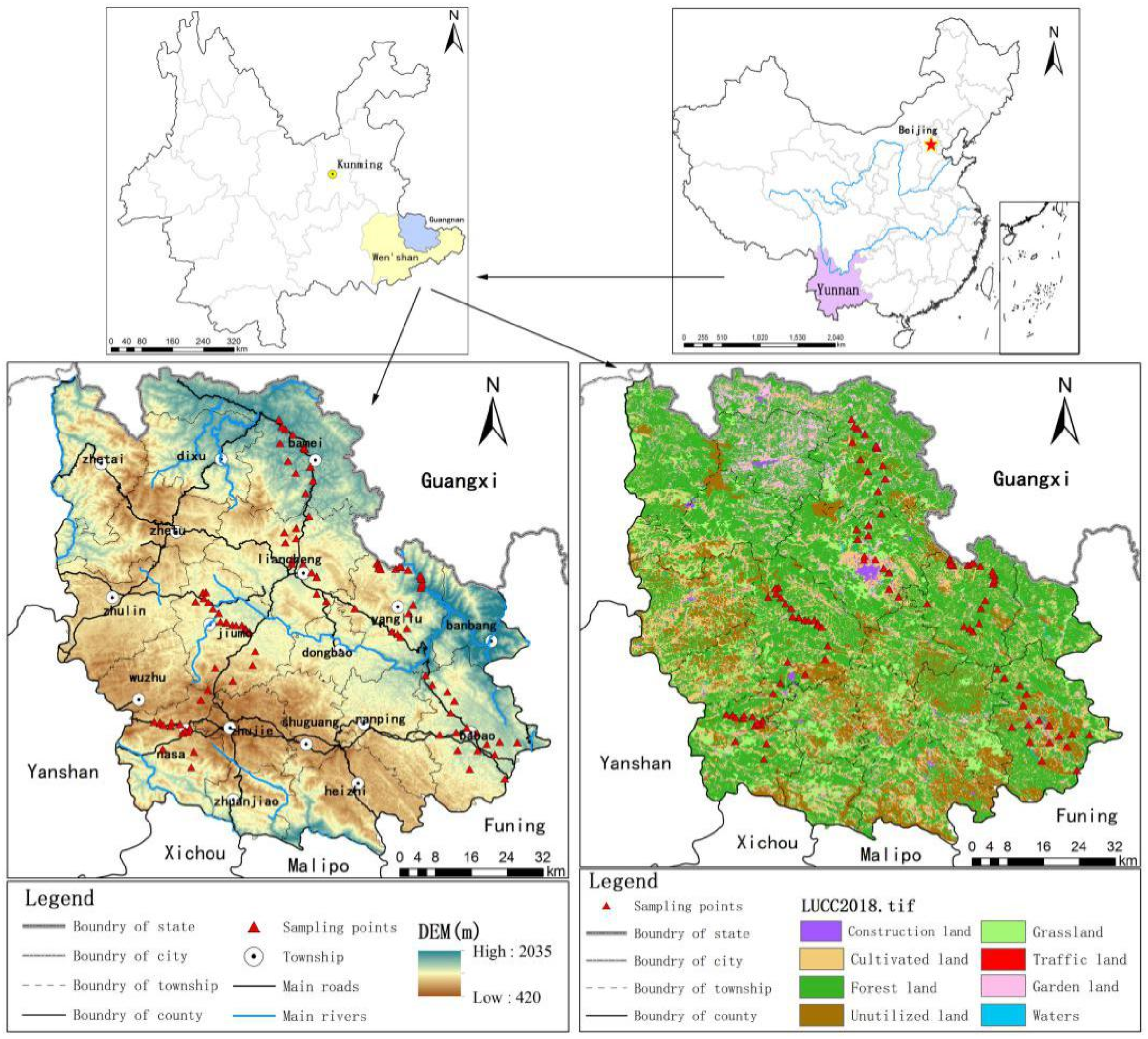
2.1. Study Area
2.2. Data Sources and Processing
3. Research Methods
3.1. Identification of Ecological Sources
3.1.1. Ecosystem Services
3.1.2. Hot Spot Analysis
3.2. Determination of Landscape Resistance Surface
3.2.1. Determination of Resistance Factors and Basic Resistance Coefficient
3.2.2. Correction of the Basic Resistance Surfaces
3.2.3. Scope of Ecological Corridors and Ecological Restoration Points
4. Results and Analysis
4.1. Spatial Distribution of Ecosystem Services and Analysis of Cold and Hot Spots
4.2. Identification of Major Ecological Sources
4.3. Construction of Comprehensive Resistance Surface
4.4. Ecological Corridor and Ecological Restoration Point
5. Discussion
5.1. Discussion on Resistance Surface Construction in Karst Mountain Area
5.2. Ecological Corridor Scope Based on Ant Algorithm
5.3. Research Shortcomings and Prospect
6. Conclusions
Author Contributions
Funding
Institutional Review Board Statement
Informed Consent Statement
Data Availability Statement
Conflicts of Interest
References
- Liu, Y.; Yang, R. The spatial characteristics and formation mechanism of the county urbanization in China. Acta Geogr. Sin. 2012, 67, 1011–1020. [Google Scholar]
- Naveh, Z. From biodiversity to ecodiversity: A landscape-ecology approach to conservation and restoration. Restor. Ecol. 1994, 2, 180–189. [Google Scholar] [CrossRef]
- Liu, Y.; Fang, F.; Li, Y. Key issues of land use in China and implications for policy making. Landusepolicy 2014, 40, 6–12. [Google Scholar] [CrossRef]
- Bourgoin, C.; Oszwald, J.; Bourgoin, J.; Gond, V.; Blanc, L.; Dessard, H.; Phan, T.V.; Sist, P.; Läderach, P.; Reymondin, L. Assessing the ecological vulnerability of forest landscape to agricultural frontier expansion in the Central Highlands of Vietnam. Int. J. Appl. Earth Obs. Geoinf. 2020, 84, 101958–101970. [Google Scholar] [CrossRef]
- Li, S.; Zhao, X.; Pu, J.; Miao, P.; Tan, K. Optimize and control territorial spatial functional areas to improve the ecological stability and total environment in Karst areas of southwest China. Land Use Policy 2021, 100, 104940–104955. [Google Scholar] [CrossRef]
- Gerten, D.; Rockstrom, J.; Heinke, J.; Steffen, W.; Richardson, K.; Ornell, S.C. Response to comment on “Planetary boundaries: Guiding human development on a changing planet”. Science 2015, 348, 1217. [Google Scholar] [CrossRef] [PubMed] [Green Version]
- Serra-Llobet, A.; Hermida, M.A. Opportunities for green infrastructure under ecuador’s new legal framework. Landsc. Urban Plan. 2017, 159, 1–4. [Google Scholar] [CrossRef] [Green Version]
- Peng, J.; Pan, Y.; Liu, Y.; Zhao, H.; Wang, Y. Linking ecological degradation risk to identify ecological security patterns in a rapidly urbanizing landscape. Habitat Int. 2018, 71, 110–124. [Google Scholar] [CrossRef]
- Reynolds, J.F.; Smith, D.; Lambin, E.F.; Ii, B.; Mortimore, M.; Batterbury, S. Global desertification: Building a science for dryland development. Science 2007, 316, 847–851. [Google Scholar] [CrossRef] [Green Version]
- Wang, Y.; Pan, J. Building ecological security patterns based on ecosystem services value reconstruction in an arid inland basin: A case study in Ganzhou District, NW China. J. Clean. Prod. 2019, 241, 118337. [Google Scholar] [CrossRef]
- George, G.R.H.; Richard, R.A.F. Communicating clearly about conservation corridors. Landsc. Urban Plan. 2001, 55, 195–208. [Google Scholar] [CrossRef]
- Day, R. Maritime spatial planning||zoning, a fundamental cornerstone of effective marine spatial planning: Lessons learnt from the great barrier reef, Australia. J. Coast. Conserv. 2011, 15, 271–278. [Google Scholar] [CrossRef]
- Liu, J.; Mooney, H.; Hull, V.; Davis, S.J.; Gaskell, J.; Hertel, T.; Lubchenco, J.; Seto, K.C.; Gleick, P.; Kremen, C.; et al. Systems integration for global sustainability. Science 2015, 347, 1258832. [Google Scholar] [CrossRef] [PubMed] [Green Version]
- Dong, S.; Kassam, K.; Tourrand, J.F.; Boone, R.B. Building Resilience of Human-Natural Systems of Pastoralism in the Developing World; Springer: Cham, Switzerland, 2016. [Google Scholar] [CrossRef] [Green Version]
- You, W.; He, D.; Hong, W.; Wu, L.; Ji, Z.; You, H.; Tan, Y.; Zheng, X. Identification for tourism disturbance sensitive areas and their protection based on landscape security pattern in world mixed heritage site Wuyishan scenery district. Mt. Res. 2014, 32, 195–204. (In Chinese) [Google Scholar] [CrossRef]
- Aminzadeh, B.; Khansefid, M. A case study of urban ecological networks and a sustainable city: Tehran’s metropolitan area. Urban Ecosyst. 2010, 13, 23–36. [Google Scholar] [CrossRef]
- Zhao, X.; Xu, X. Research on landscape ecological security pattern in a Eucalyptus introduced region based on biodiversity conservation. Russ. J. Ecol. 2015, 46, 59–70. [Google Scholar] [CrossRef]
- Wang, C.; Yu, C.; Chen, T.; Feng, Z.; Wu, K. Can the establishment of ecological security patterns improve ecological protection? An example of Nanchang, China. Sci. Total Environ. 2020, 740, 140051–140093. [Google Scholar] [CrossRef]
- Hofman, M.; Hayward, M.W.; Kelly, M.J.; Kelly, M.J.; Niko, B. Enhancing conservation network design with graph-theory and a measure of protected area effectiveness: Refining wildlife corridors in Belize, Central America. Landsc. Urban Plan. 2018, 178, 51–59. [Google Scholar] [CrossRef]
- Loro, M.; Ortega, E.; Arce, R.M.; Geneletti, D. Ecological connectivity analysis to reduce the barrier effect of roads. An innovative graph-theory approach to define wildlife corridors with multiple paths and without bottlenecks. Landsc. Urban Plan. 2015, 139, 149–162. [Google Scholar] [CrossRef] [Green Version]
- Salicrup, P.; Diego, R.; Ayram, C.; Camilo, A.; Andres, E. Habitat connectivity in biodiversity conservation: A review of recent studies and applications. Prog. Phys. Geogr. 2016, 40, 7–37. [Google Scholar] [CrossRef]
- Rouget, M.; Cowling, R.M.; Lombard, A.T.; Knight, A.T.; Kerley, G.I.H. Designing Large-Scale Conservation Corridors for Pattern and Process. Conserv. Biol. 2010, 20. [Google Scholar] [CrossRef]
- Ebru, E.; Anna, J.; Wa, R.R.; En, P.H. Identifying Multispecies Connectivity Corridors and the Spatial Pattern of the Landscape. Urban For. Urban Green. 2018. [Google Scholar] [CrossRef]
- Pardini, R.; Souza, S.M.D.; Braga-Neto, R. The role of forest structure, fragment size and corridors in maintaining small mammal abundance and diversity in an Atlantic forest landscape. Biol. Conserv. 2005, 124, 253–266. [Google Scholar] [CrossRef]
- Fu, Y.; Shi, X.; He, J.; Yuan, Y.; Qu, L. Identification and optimization strategy of county ecological security pattern: A case study in the loess plateau, China. Ecol. Indic. 2020, 112, 106030. [Google Scholar] [CrossRef]
- Zhang, L.; Jian, P.; Liu, Y.; Wu, J. Coupling ecosystem services supply and human ecological demand to identify landscape ecological security pattern: A case study in Beijing-Tianjin-Hebei region, China. Urban Ecosyst. 2017, 20, 1–14. [Google Scholar] [CrossRef]
- Liu, X.; Wei, M.; Zeng, J. Simulating urban growth scenarios based on ecological security pattern: A case study in Quanzhou, China. Int. J. Environ. Res. Public Health 2020, 17, 7282. [Google Scholar] [CrossRef]
- Almenar, J.B.; Bolowich, A.; Elliot, T. Assessing habitat loss, fragmentation and ecological connectivity in Luxembourg to support spatial planning. Landsc. Urban Plan. 2019, 189, 335–351. [Google Scholar] [CrossRef]
- Carroll, C.; Mcrae, B.H.; Brookes, A. Use of Linkage Mapping and Centrality Analysis Across Habitat Gradients to Conserve Connectivity of Gray Wolf Populations in Western North America. Conserv. Biol. 2012, 26. [Google Scholar] [CrossRef] [PubMed]
- Dickson, B.G.; Albano, C.M.; Gray, M.E. Circuit-theory applications to connectivity science and conservation. Conserv. Biol. 2018, 33. [Google Scholar] [CrossRef] [PubMed]
- Colorni, A. Distributed optimization by ant colonies. In Proceedings of the First European Conference on Artificial Life, Paris, France, 11–13 December 1991; The MIT Press: Cambridge, MA, USA, 1991. [Google Scholar]
- Bona Be Au, E.; Dorigo, M.; Theraulaz, G. Inspiration for Optimization from Social Insect Behavior. Nature 2000, 406, 39–42. [Google Scholar] [CrossRef]
- Li, Y.; Hilton, A. Optimal groundwater monitoring design using an ant colony optimization paradigm. Environ. Model. Softw. 2007, 22, 110–116. [Google Scholar] [CrossRef]
- Dorigo, M.; Maniezzo, V. Ant system: Optimization by a colony of cooperating agents. IEEE Trans. Cybern. 1996, 26, 29. [Google Scholar] [CrossRef] [Green Version]
- Liu, J.; Yang, J.; Liu, H. An improved ant colony algorithm for robot path planning. Soft Comput. 2017. [Google Scholar] [CrossRef]
- Fang, W.; Ai, S.; Wang, Q.; Fan, J. Research on Cold Chain Logistics Distribution Path Optimization Based on Hybrid Ant Colony Algorithm. Chin. J. Manag. Sci. 2019, 27, 107–115. (In Chinese) [Google Scholar] [CrossRef]
- Yue, L.; Chen, H. Unmanned vehicle path planning using a novel ant colony algorithm. EURASIP J. Wirel. Commun. Netw. 2019, 2019. [Google Scholar] [CrossRef] [Green Version]
- Nguyen, D.; Ascough, J.C.I.; Maier, H.R. Optimization of irrigation scheduling using ant colony algorithms and an advanced cropping system model. Environ. Model. Softw. 2017, 97, 32–45. [Google Scholar] [CrossRef]
- Xiao, S.; Wu, W.; Guo, J.; Ou, M.; Tao, Y. An evaluation framework for designing ecological security patterns and prioritizing ecological corridors: Application in Jiangsu province, China. Landsc. Ecol. 2020, 35, 1–18. [Google Scholar] [CrossRef]
- Ztl, A.; Miao, L.A.; Bcxa, B. Spatio-temporal dynamics of ecological security pattern of the Pearl River Delta urban agglomeration based on LUCC simulation. Ecol. Indic. 2020, 114, 106319–106328. [Google Scholar] [CrossRef]
- Xu, J.; Fan, F.; Liu, Y.; Dong, J.; Chen, J. Construction of ecological security patterns in nature reserves based on ecosystem services and circuit theory: A case study in Wenchuan, China. Int. J. Environ. Res. Public Health 2019, 16, 3220. [Google Scholar] [CrossRef] [Green Version]
- Potter, C.S.; Randerson, J.T.; Field, C.B.; Matson, P.A.; Klooster, S.A. Terrestrialecosystem production: A process model based on global satellite and surface data. Glob. Biogeochem. Cycles 1993, 7, 811–841. [Google Scholar] [CrossRef]
- Gong, J.; Xie, Y.; Erjia, C.; Huang, Q.; Li, H. Integration of invest-habitat quality model with landscape pattern indexes to assess mountain plant biodiversity change: A case study of Bailongjiang watershed in Gansu province. J. Geogr. Sci. 2019, 29, 1193–1210. [Google Scholar] [CrossRef] [Green Version]
- Ebrahimzadeh, S.; Motagh, M.; Mahboub, V.; Harijani, F.M. An improved RUSLE/SDR model for the evaluation of soil erosion. Environ. Earth Sci. 2018, 77, 454–470. [Google Scholar] [CrossRef]
- Neskili, N.T.; Zahraie, B.; Saghafian, B. Coupling snow accumulation and melt rate modules of monthly water balance models with the Jazim monthly water balance model. Hydrol. Sci. J. 2017, 62, 1–21. [Google Scholar] [CrossRef]
- Getis, A.; Ord, J.K. The Analysis of Spatial Association by Use of Distance Statistics; Springer: Berlin/Heidelberg, Germany, 1992; Volume 24, pp. 189–206. [Google Scholar] [CrossRef]
- Peng, J.; Yang, Y.; Liu, Y.; Hu, Y.; Du, Y.; Meersmans, J. Linking ecosystem services and circuit theory to identify ecological security patterns. Sci. Total Environ. 2018, 644, 781–790. [Google Scholar] [CrossRef] [PubMed] [Green Version]
- Wang, K.; Yue, Y.; Ma, Y.; Lei, T.; Li, D.; Song, T. Research and demonstration on technologies for rocky desertification treatment and ecosystem services enhancement in Karst peak-cluster depression regions. Acta Ecol. Sin. 2016, 36, 7098–7102. (In Chinese) [Google Scholar] [CrossRef]
- Huang, M.; Yue, W.; Feng, S.; Cai, J. Analysis of spatial heterogeneity of ecological security based on MCR model and ecological pattern optimization in the Yuexi county of the Dabie Mountain Area. J. Nat. Resour. 2019, 34, 771–784. (In Chinese) [Google Scholar] [CrossRef]
- Peng, J.; Guo, X.; Hu, Y.; Liu, Y. Constructing ecological security patterns in mountain areas based on geological disaster sensitivity: A case study in Yuxi City, Yunnan Province, China. Chin. J. Appl. Ecol. 2017, 28, 627–635. (In Chinese) [Google Scholar] [CrossRef]
- Zhao, X.; He, C. Landscape ecological security pattern associated with the introduction of exotictree species Eucalyptus. Acta Ecol. Sin. 2013, 33, 1860–1871. (In Chinese) [Google Scholar] [CrossRef]
- Su, Y.; Zhang, H.; Chen, X.; Huang, G.; Ye, Y.; Wu, Q.; Huang, N.; Kuang, Y. The ecological security patterns and construction land expansion simulation in Gaoming. Acta Ecol. Sin. 2013, 33, 1524–1534. (In Chinese) [Google Scholar] [CrossRef]
- Yin, H.; Kong, F.; Qi, Y.; Wang, H.; Zhou, Y.; Qin, Z. Developing and optimizing ecological networks in urban agglomeration of Hunan Province, China. Acta Ecol. Sin. 2011, 31, 2863–2874. (In Chinese) [Google Scholar]
- Yu, K.; Li, H.; Li, D.; Qiao, Q.; Xi, X. National scale ecological security pattern. Acta Ecol. Sin. 2009, 29, 5163–5175. (In Chinese) [Google Scholar] [CrossRef]
- Kang, J.; Zhang, X.; Zhu, X.; Zhang, B. Ecological security pattern: A new idea for balancing regional development and ecological protection. A case study of the A Jiaodong peninsula, China. Glob. Ecol. Conserv. 2021, 26, e10472. [Google Scholar] [CrossRef]
- Gregory, A.; Spence, E.; Beier, P.; Garding, E. Toward best management practices for ecological corridors. Land 2021, 10, 140. [Google Scholar] [CrossRef]
- Kong, F.; Yin, H.; Nakagoshi, N.; Zong, Y. Urban green space network development for biodiversity conservation: Identification based on graph theory and gravity modeling. Landsc. Urban Plan. 2010, 95, 16–27. [Google Scholar] [CrossRef]
- Gao, Y.; Ma, L.; Liu, J.; Zhuang, Z.; Huang, Q.; Li, M. Constructing ecological networks based on habitat quality assessment: A case study of Changzhou, China. Sci. Rep. 2017, 7, 4607–4617. [Google Scholar] [CrossRef]
- Dong, J.; Peng, J.; Liu, Y.; Qiu, S.; Han, Y. Integrating spatial continuous wavelet transform and kernel density estimation to identify ecological corridors in megacities. Landsc. Urban Plan. 2020, 199, 103815–103823. [Google Scholar] [CrossRef]
- Peng, J.; Zhao, S.; Dong, J.; Liu, Y.; Meersmans, J.; Li, H.; Wu, J. Applying ant colony algorithm to identify ecological security patterns in megacities. Environ. Model. Softw. 2019, 117, 214–222. [Google Scholar] [CrossRef] [Green Version]
- Green, S.M.; Dungait, J.; Tu, C.; Buss, H.L.; Sanderson, N.; Hawkes, S.J. Soil functions and ecosystem services research in the Chinese Karst critical zone. Chem. Geol. 2019, 527, 119107–119160. [Google Scholar] [CrossRef] [Green Version]
- Yang, Q.; Zhang, F.; Jiang, Z.; Yuan, D.; Yong, J. Assessment of water resource carrying capacity in Karst area of Southwest China. Environ. Earth Sci. 2016, 75, 1–8. [Google Scholar] [CrossRef]
- Gao, J.; Du, F.; Zuo, L.; Jiang, Y. Integrating ecosystem services and rocky desertification into identification of Karst ecological security pattern. Landsc. Ecol. 2020, 1–21. [Google Scholar] [CrossRef]
- Zhao, X.; Tan, K.; Yi, Q.; Li, S.; Miao, P.; Pu, J. Construction of ecological security pattern in typical plateau lake basin-A case of the Qilu lake basin. China Environ. Sci. 2019, 39, 768–777. (In Chinese) [Google Scholar] [CrossRef]
- Wanghe, K.; Guo, X.; Wang, M.; Zhuang, H.; Li, K. Gravity model toolbox: An automated and open-source arcgis tool to build and prioritize ecological corridors in urban landscapes. Glob. Ecol. Conserv. 2020, 22, e01012. [Google Scholar] [CrossRef]
- Mao, X.; Meng, J.; Xiang, Y. Cellular automata-based model for developing land use ecological security patterns in semi-arid areas: A case study of Ordos, Inner Mongolia, China. Environ. Earth Sci. 2013, 70, 269–279. [Google Scholar] [CrossRef]
- Harrison, R.L. Toward a theory of inter-refuge corridor design. Conserv. Biol. 1992, 6, 293–295. [Google Scholar] [CrossRef]
- Zeller, K.A.; McGarigal, K.; Beier, P.; Cushman, S.A.; Vickers, T.W.; Boyce, W.M. Sensitivity of landscape resistance estimates based on point selection functions to scale and behavioral state: Pumas as a case study. Landsc. Ecol. 2014, 29, 541–557. [Google Scholar] [CrossRef]
- Gan, Y.; He, Y.; Gao, L.; He, W. Propagation path optimization of product attribute design changes based on petri net fusion ant colony algorithm. Expert Syst. Appl. 2021, 173, 114664–114675. [Google Scholar] [CrossRef]
- Zheng, Y.; Luo, Q.; Wang, H.; Chen, X. Path planning of mobile robot based on adaptive ant colony algorith. J. Intell. Fuzzy Syst. 2020, 39, 5329–5338. [Google Scholar] [CrossRef]
- Handler, G.Y.; Zang, I. A dual algorithm for the constrained shortest path problem. Networks 2010, 10, 293–309. [Google Scholar] [CrossRef]
- Sun, N.; Shi, H.; Han, G.; Wang, B.; Shu, L. Dynamic path planning algorithms with load balancing based on data prediction for smart transportation system. IEEE Access 2020, 8, 15907–15922. [Google Scholar] [CrossRef]


| Evaluation Types | Formula | Parameters |
|---|---|---|
| NPP | NPPt = APARt × εt | where NPPt, APARt and εt are the NPP, photo-synthetically active radiation absorbed by vegetation and light energy conversion rate of vegetation at spatial location x and time period t, respectively. |
| Habitat maintenance | where Qxj and Hj are the habitat quality and habitat attribute of land use type j, respectively; k is a semi-saturated constant; z is a model default value; Dxj is habitat degradation. | |
| Soil conservation | where A represents the average annual soil conservation; K is soil erodibility factor; P is soil conservation measure factor; R, LS and C are the rainfall erosion factor, terrain factor and the cover-management factor, respectively. | |
| Water resources supply | / | where W is the annual water resources supply, P, ET and Q are the annual precipitation, annual evapotranspiration and surface runoff, respectively. |
| Food supply | / | where ck is the average value of food supply energy per unit area in region k ; Pmk is the unit area yield of m crops in the region k ; Am is the energy of m crops |
| Resistance Factors | Factor Weight | Resistance Classification | Basic Resistance Coefficient |
|---|---|---|---|
| Land cover type | 0.1671 | Forest land | 5 |
| Grassland | 10 | ||
| Garden Land | 20 | ||
| Cultivated land | 30 | ||
| Waters | 50 | ||
| Unutilized land | 70 | ||
| Traffic land | 80 | ||
| Construction Land | 100 | ||
| Slope (°) | 0.1198 | 0–15 | 10 |
| 15–25 | 30 | ||
| 25–35 | 50 | ||
| >35 | 80 | ||
| Altitude (m) | 0.2054 | <800 | 10 |
| 800–1300 | 30 | ||
| 1300–1500 | 50 | ||
| >1500 | 80 | ||
| Vegetation coverage (%) | 0.1436 | <35 | 10 |
| 35–50 | 30 | ||
| 50–65 | 50 | ||
| >65 | 80 | ||
| Soil thickness | 0.1496 | <10 | 10 |
| 10–30 | 40 | ||
| >30 | 70 | ||
| Bedrock type | 0.2145 | Non-carbonate rock | 10 |
| Limestone | 30 | ||
| Interformation of limestone and dolomite | 50 | ||
| Dolomite | 70 | ||
| Carbonate rock with clastic rock | 90 |
Publisher’s Note: MDPI stays neutral with regard to jurisdictional claims in published maps and institutional affiliations. |
© 2021 by the authors. Licensee MDPI, Basel, Switzerland. This article is an open access article distributed under the terms and conditions of the Creative Commons Attribution (CC BY) license (https://creativecommons.org/licenses/by/4.0/).
Share and Cite
Zhao, X.; Yue, Q.; Pei, J.; Pu, J.; Huang, P.; Wang, Q. Ecological Security Pattern Construction in Karst Area Based on Ant Algorithm. Int. J. Environ. Res. Public Health 2021, 18, 6863. https://doi.org/10.3390/ijerph18136863
Zhao X, Yue Q, Pei J, Pu J, Huang P, Wang Q. Ecological Security Pattern Construction in Karst Area Based on Ant Algorithm. International Journal of Environmental Research and Public Health. 2021; 18(13):6863. https://doi.org/10.3390/ijerph18136863
Chicago/Turabian StyleZhao, Xiaoqing, Qifa Yue, Jianchao Pei, Junwei Pu, Pei Huang, and Qian Wang. 2021. "Ecological Security Pattern Construction in Karst Area Based on Ant Algorithm" International Journal of Environmental Research and Public Health 18, no. 13: 6863. https://doi.org/10.3390/ijerph18136863