
Integrating the Ecological Security Pattern and the PLUS Model to Assess the Effects of Regional Ecological Restoration: A Case Study of Hefei City, Anhui Province


Abstract
:1. Introduction
2. Study Area and Data Sources
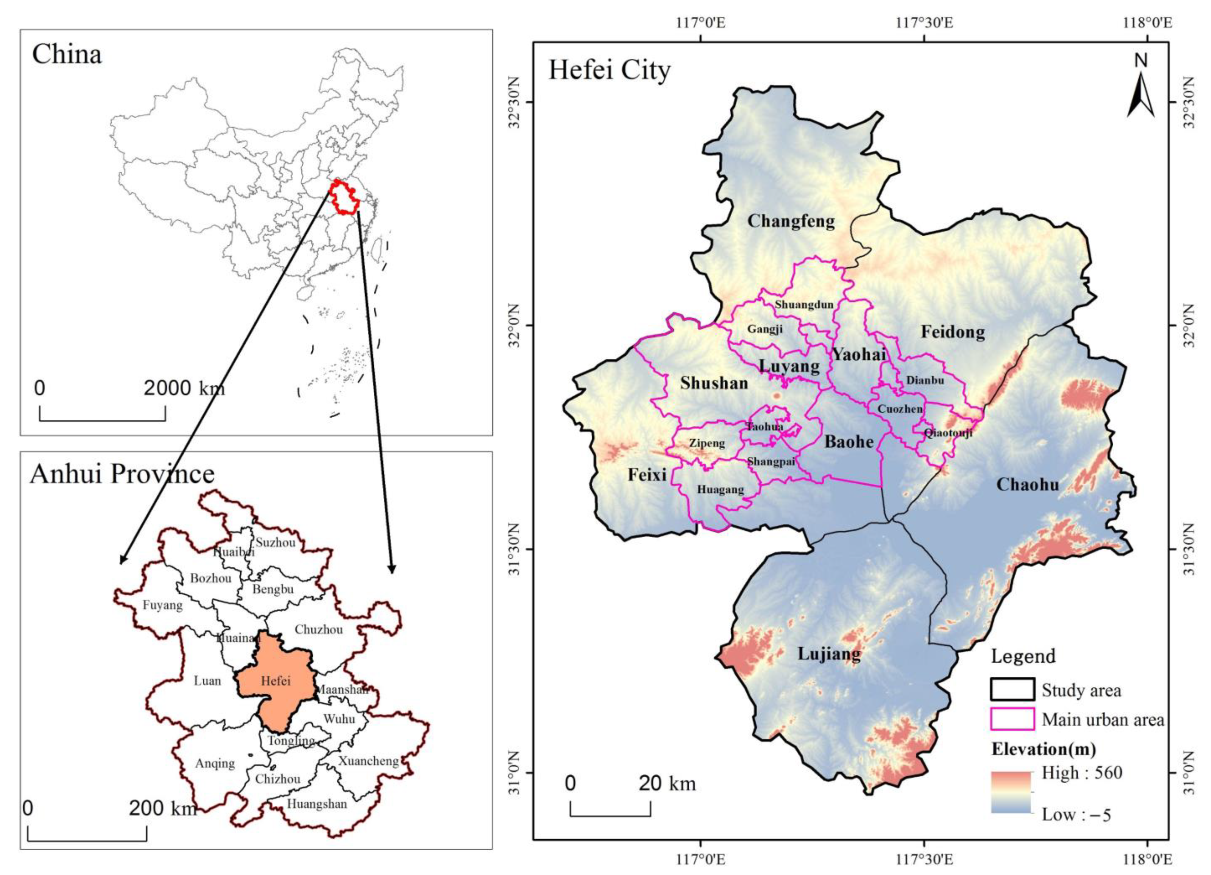
2.1. Study Area
2.2. Data Sources
3. Methods
3.1. Simulation of Land Use
3.1.1. The PLUS Model
3.1.2. Model Validation
3.2. Construstion of the Ecological Security Pattern
3.2.1. Identifying Ecological Sources Based on MSPA
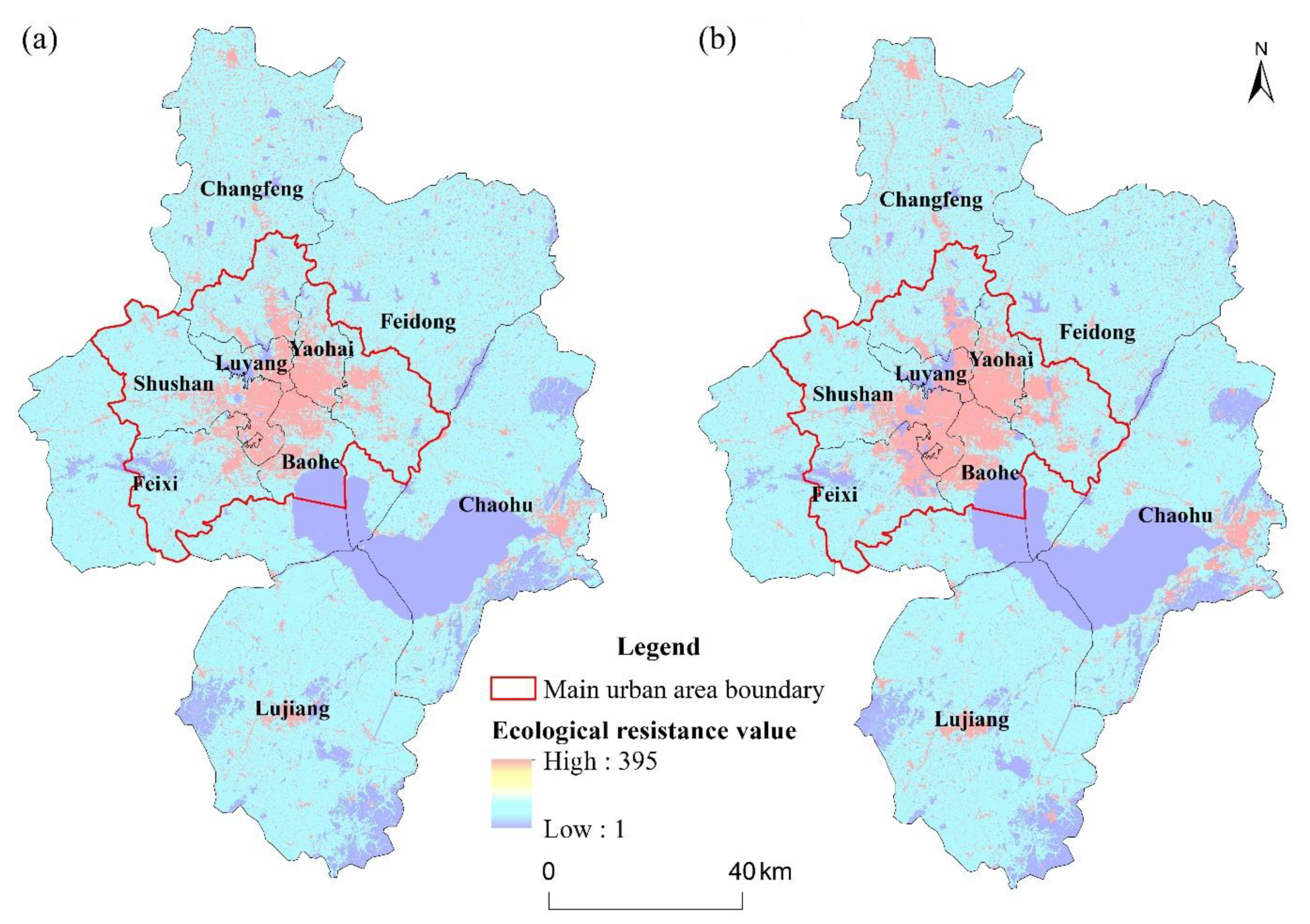
3.2.2. Constructing Ecological Resistance Surfaces
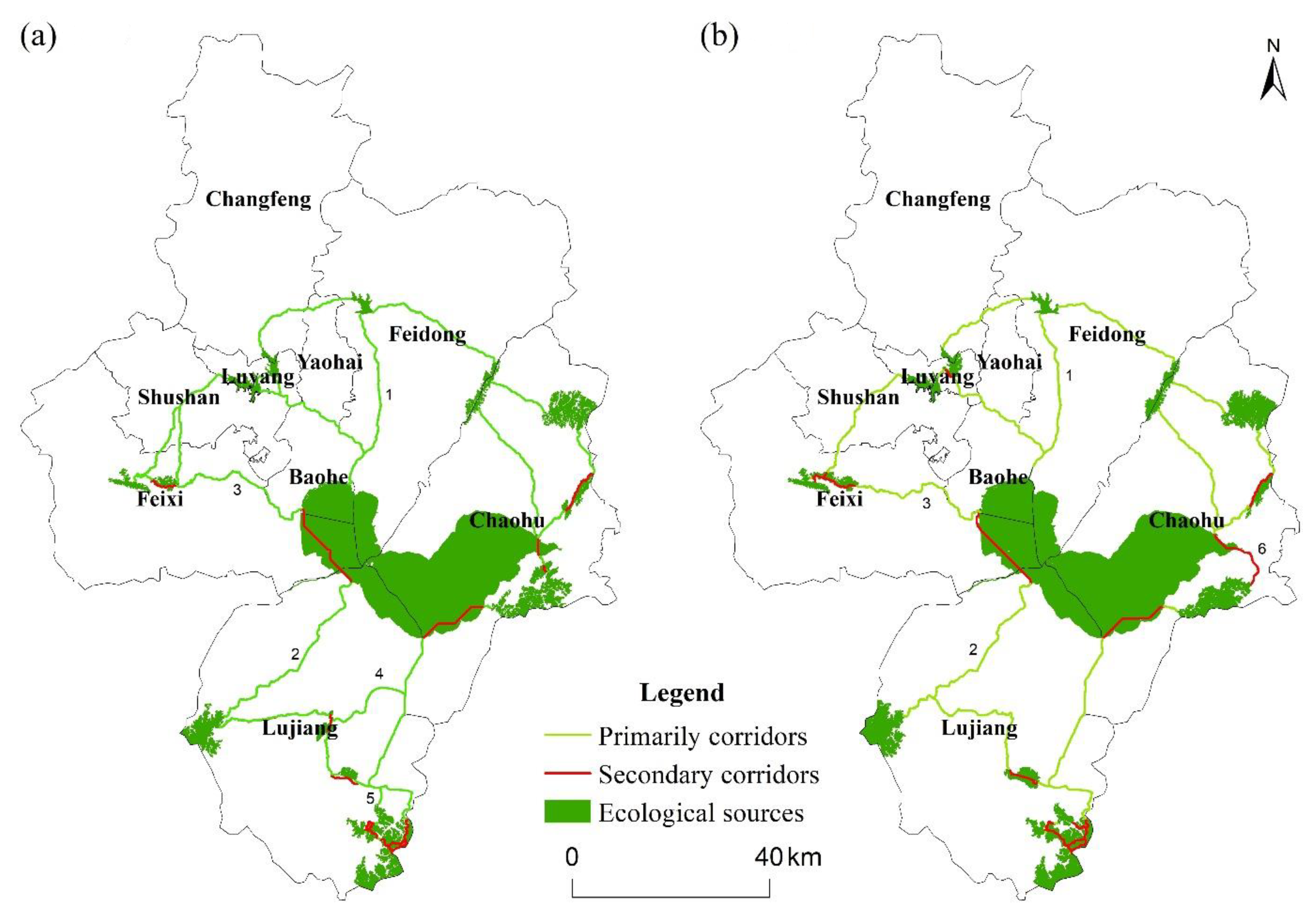
3.2.3. Extracting Ecological Corridors
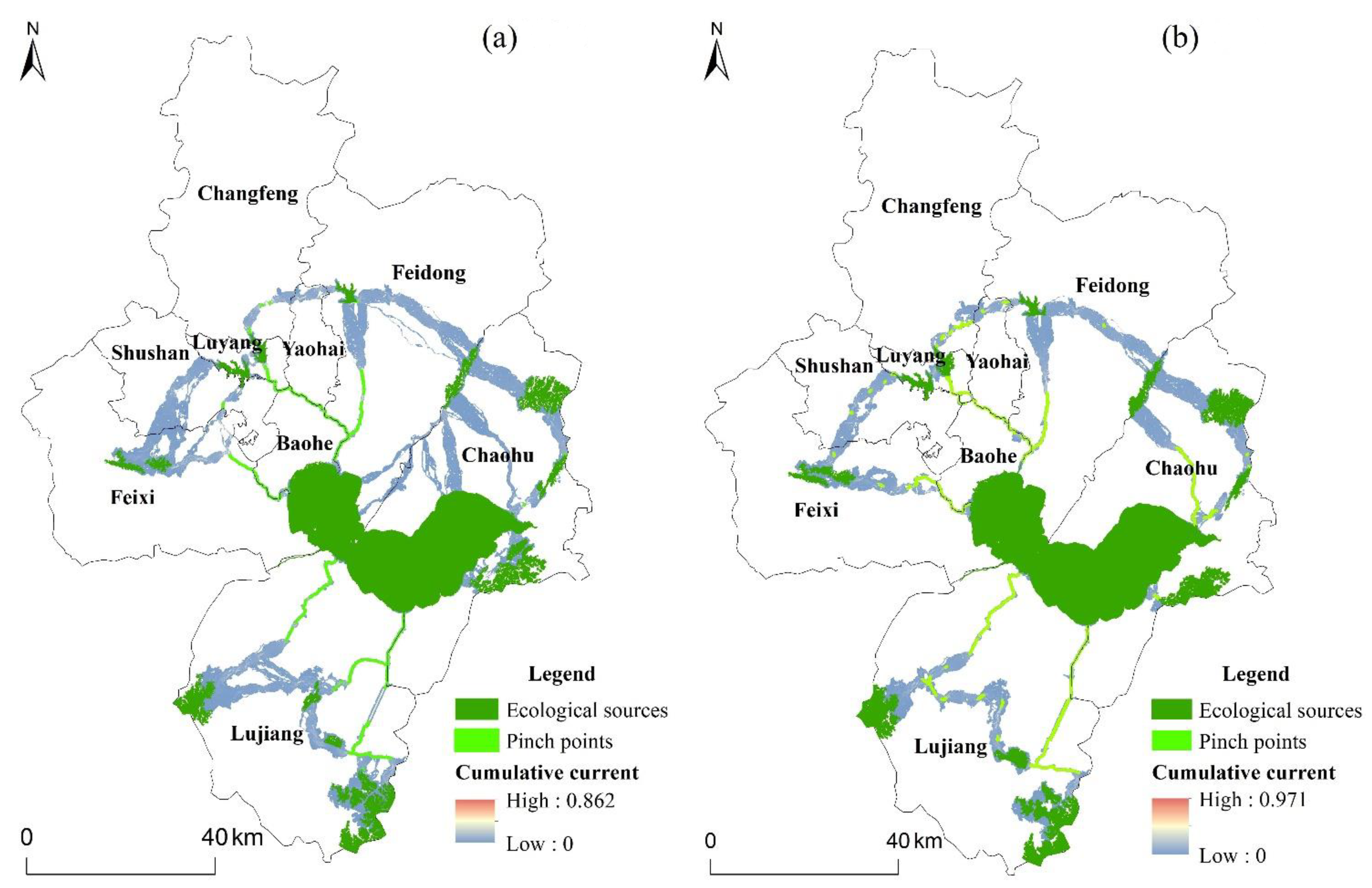
3.2.4. Identifying Ecological Strategic Nodes
4. Results
4.1. Simulation of Land-Use Pattern
4.1.1. Simulation Accuracy
4.1.2. Simulation Results
4.2. Ecological Security Pattern
4.2.1. Ecological Sources Analysis
4.2.2. Integrated Ecological Resistance Surface
4.2.3. Spatial Pattern of Ecological Corridors
4.2.4. Ecological Strategic Nodes
5. Discussion
5.1. Comparison of Related Studies
5.2. Proposals for Further Strengthening Ecological Restoration in the Next Decade
5.3. Uncertainties and Prospects
6. Conclusions
- (1)
- From 2020 to 2030, land-use changes would occur primarily in the main urban area of Hefei and along the eastern shore of the Chaohu Lake watershed. Under the ecological protection scenario, large amounts of arable land would be converted to construction land and woodland.
- (2)
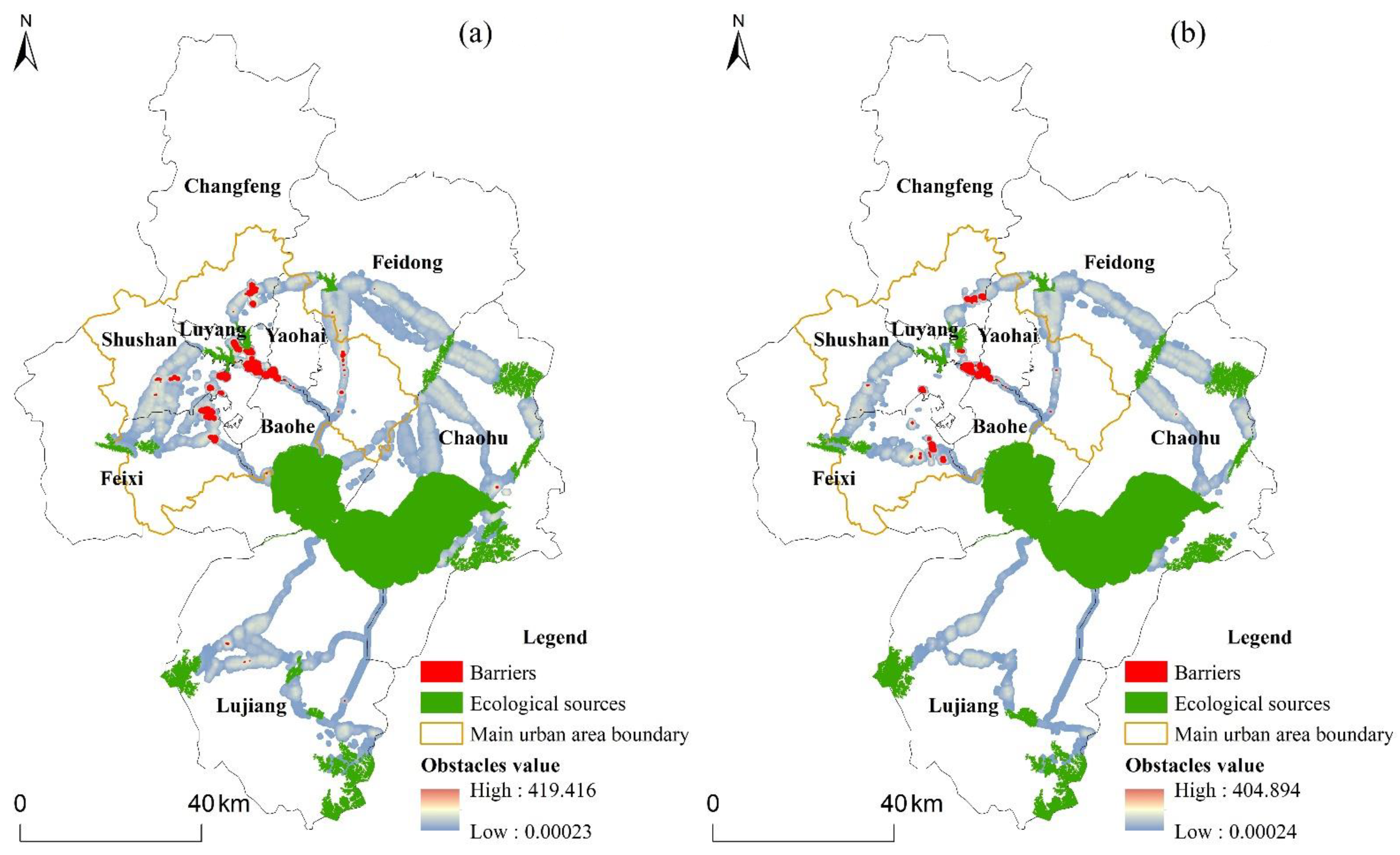
- There was an increase in the area of ecological sources and pinch points from 2020 to 2030, and a notable reduction in the number and area of barriers. Overall, these results indicated that the ecosystem quality, ecological integrity, and landscape connectivity of Hefei would be considerably improved.
Author Contributions
Funding
Institutional Review Board Statement
Informed Consent Statement
Data Availability Statement
Acknowledgments
Conflicts of Interest
References
- Serra-Llobet, A.; Hermida, M.A. Opportunities for green infrastructure under Ecuador’s new legal framework. Landsc. Urban Plan. 2017, 159, 1–4. [Google Scholar] [CrossRef] [Green Version]
- Cumming, G.S.; Allen, C.R. Protected areas as social-ecological systems: Perspectives from resilience and social-ecological systems theory. Ecol. Appl. 2017, 27, 1709–1717. [Google Scholar] [CrossRef] [PubMed]
- Cetin, M. The effect of urban planning on urban formations determining bioclimatic comfort area’s effect using satellitia imagines on air quality: A case study of Bursa city. Air Qual. Atmos. Health 2019, 12, 1237–1249. [Google Scholar] [CrossRef]
- Cho, S.-H.; Poudyal, N.; Lambert, D.M. Estimating spatially varying effects of urban growth boundaries on land development and land value. Land Use Policy 2008, 25, 320–329. [Google Scholar] [CrossRef]
- Esbah, H.; Cook, E.A.; Ewan, J. Effects of increasing urbanization on the ecological integrity of open space preserves. Environ. Manag. 2009, 43, 846–862. [Google Scholar] [CrossRef] [PubMed]
- Benedict, M.A.; McMahon, E.T. Green infrastructure: Smart conservation for the 21st century. Renew. Resour. J. 2002, 20, 12–17. [Google Scholar]
- Huang, J.; Hu, Y.; Zheng, F. Research on recognition and protection of ecological security patterns based on circuit theory: A case study of Jinan City. Environ. Sci. Pollut. Res. 2020, 27, 12414–12427. [Google Scholar] [CrossRef]
- Canfei, H.; Tianming, C.; Xiyan, M.; Yi, Z. Economic transition, urbanization and population redistribution in China. Habitat Int. 2016, 51, 39–47. [Google Scholar]
- Juknelienė, D.; Kazanavičiūtė, V.; Valčiukienė, J.; Atkocevičienė, V.; Mozgeris, G. Spatiotemporal Patterns of Land-Use Changes in Lithuania. Land 2021, 10, 619. [Google Scholar] [CrossRef]
- Jennifer, K.; Florian, W.; Rüdiger, S. Analyzing the relationship between urbanization, food supply and demand, and irrigation requirements in Jordan. Sci. Total Environ. 2018, 636, 1500–1509. [Google Scholar]
- Marina, A. Maintaining ecological integrity and sustaining ecosystem function in urban areas. Curr. Opin. Environ. Sustain. 2010, 2, 178–184. [Google Scholar]
- Samat, N.; Mahamud, M.A.; Tan, M.L.; Maghsoodi Tilaki, M.J.; Tew, Y.L. Modelling Land Cover Changes in Peri-Urban Areas: A Case Study of George Town Conurbation, Malaysia. Land 2020, 9, 373. [Google Scholar] [CrossRef]
- Cao, Y.; Bai, Z.; Sun, Q.; Zhou, W. Rural settlement changes in compound land use areas: Characteristics and reasons of changes in a mixed mining-rural-settlement area in Shanxi Province, China. Habitat Int. 2017, 61, 9–21. [Google Scholar] [CrossRef]
- Darvishi, A.; Yousefi, M.; Marull, J. Modelling landscape ecological assessments of land use and cover change scenarios. Application to the Bojnourd Metropolitan Area (NE Iran). Land Use Policy 2020, 99, 105098. [Google Scholar] [CrossRef]
- Tobler, W.R. Cellular geography. In Philosophy in Geography; Springer: Berlin/Heidelberg, Germany, 1979; pp. 379–386. [Google Scholar]
- Barredo, J.I.; Kasanko, M.; McCormick, N.; Lavalle, C. Modelling dynamic spatial processes: Simulation of urban future scenarios through cellular automata. Landsc. Urban Plan. 2003, 64, 145–160. [Google Scholar] [CrossRef]
- Xu, L.; Huang, Q.; Ding, D.; Mei, M.; Qin, H. Modelling urban expansion guided by land ecological suitability: A case study of Changzhou City, China. Habitat Int. 2018, 75, 12–24. [Google Scholar] [CrossRef]
- Sohl, T.L.; Claggett, P.R. Clarity versus complexity: Land-use modeling as a practical tool for decision-makers. J. Environ. Manag. 2013, 129, 235–243. [Google Scholar] [CrossRef]
- Gharaibeh, A.; Shaamala, A.; Obeidat, R.; Al-Kofahi, S. Improving land-use change modeling by integrating ANN with Cellular Automata-Markov Chain model. Heliyon 2020, 6, e05092. [Google Scholar] [CrossRef]
- Verburg, P.H.; Soepboer, W.; Veldkamp, A.; Limpiada, R.; Espaldon, V.; Mastura, S.S. Modeling the spatial dynamics of regional land use: The CLUE-S model. Environ. Manag. 2002, 30, 391–405. [Google Scholar] [CrossRef]
- Liu, X.; Liang, X.; Li, X.; Xu, X.; Ou, J.; Chen, Y.; Li, S.; Wang, S.; Pei, F. A future land use simulation model (FLUS) for simulating multiple land use scenarios by coupling human and natural effects. Landsc. Urban Plan. 2017, 168, 94–116. [Google Scholar] [CrossRef]
- Liang, X.; Guan, Q.; Clarke, K.C.; Liu, S.; Wang, B.; Yao, Y. Understanding the drivers of sustainable land expansion using a patch-generating land use simulation (PLUS) model: A case study in Wuhan, China. Comput. Environ. Urban Syst. 2021, 85, 101569. [Google Scholar] [CrossRef]
- Wang, J.; Zhang, J.; Xiong, N.; Liang, B.; Wang, Z.; Cressey, E.L. Spatial and Temporal Variation, Simulation and Prediction of Land Use in Ecological Conservation Area of Western Beijing. Remote Sens. 2022, 14, 1452. [Google Scholar] [CrossRef]
- Hodson, M.; Marvin, S. ‘Urban ecological security’: A new urban paradigm? Int. J. Urban Reg. Res. 2009, 33, 193–215. [Google Scholar] [CrossRef]
- Peng, J.; Zhao, H.J.; Liu, Y.X.; Wu, J.S. Research progress and prospect on regional ecological security pattern construction. Geogr. Res. 2017, 36, 407–419. [Google Scholar]
- Tallis, H.; Kareiva, P.; Marvier, M.; Chang, A. An ecosystem services framework to support both practical conservation and economic development. Proc. Natl. Acad. Sci. USA 2008, 105, 9457–9464. [Google Scholar] [CrossRef] [Green Version]
- Yu, K.J. Designing and Building a Beautiful City with the Vision of Ecological Civilization. Renming Luntan* Xueshu Qianyan 2020, 18–36. [Google Scholar] [CrossRef]
- Folgado-Fernández, J.A.; Di-Clemente, E.; Hernández-Mogollón, J.M.; Campón-Cerro, A.M. Water Tourism: A New Strategy for the Sustainable Management of Water-Based Ecosystems and Landscapes in Extremadura (Spain). Land 2019, 8, 2. [Google Scholar] [CrossRef] [Green Version]
- Meli, P.; Benayas, J.M.R.; Balvanera, P.; Ramos, M.M. Restoration Enhances Wetland Biodiversity and Ecosystem Service Supply, but Results Are Context-Dependent: A Meta-Analysis. PLoS ONE 2014, 9, e93507. [Google Scholar] [CrossRef]
- Li, X.; Niu, X.; Wang, B.; Gao, P.; Liu, Y. Driving Forces of Dynamic Changes in Soil Erosion in the Dahei Mountain Ecological Restoration Area of Northern China Based on GIS and RS. PLoS ONE 2016, 11, e0142331. [Google Scholar] [CrossRef]
- Han, Y.; Yu, C.Y.; Feng, Z.; Du, H.C.; Huang, C.S.; Wu, K.N. Construction and Optimization of Ecological Security Pattern Based on Spatial Syntax Classification-Taking Ningbo, China, as an Example. Land 2021, 10, 380. [Google Scholar] [CrossRef]
- Suding, K.; Higgs, E.; Palmer, M.; Callicott, J.B.; Anderson, C.B.; Baker, M.; Gutrich, J.J.; Hondula, K.L.; LaFevor, M.C.; Larson, B.M.H.; et al. Committing to ecological restoration. Science 2015, 348, 638–640. [Google Scholar] [CrossRef] [PubMed] [Green Version]
- Yang, J.; Huang, X. The 30 m annual land cover dataset and its dynamics in China from 1990 to 2019. Earth Syst. Sci. Data 2021, 13, 3907–3925. [Google Scholar] [CrossRef]
- Hu, S.; Chen, L.Q.; Li, L.; Zhang, T.; Yuan, L.N.; Cheng, L.; Wang, J.; Wen, M.X. Simulation of Land Use Change and Ecosystem Service Value Dynamics under Ecological Constraints in Anhui Province, China. Int. J. Environ. Res. Public Health 2020, 17, 4228. [Google Scholar] [CrossRef] [PubMed]
- Wang, Y.C.; Shen, J.K.; Yan, W.T.; Chen, C.D. Backcasting approach with multi-scenario simulation for assessing effects of land use policy using GeoSOS-FLUS software. MethodsX 2019, 6, 1384–1397. [Google Scholar] [CrossRef] [PubMed]
- Li, M.; Liu, S.; Wang, F.; Liu, H.; Liu, Y.; Wang, Q. Cost-benefit analysis of ecological restoration based on land use scenario simulation and ecosystem service on the Qinghai-Tibet Plateau. Glob. Ecol. Conserv. 2022, 34, e02006. [Google Scholar] [CrossRef]
- Wang, Q.; Wang, H.; Chang, R.; Zeng, H.; Bai, X. Dynamic simulation patterns and spatiotemporal analysis of land-use/land-cover changes in the Wuhan metropolitan area, China. Ecol. Model. 2022, 464, 109850. [Google Scholar] [CrossRef]
- Wang, Z.; Li, X.; Mao, Y.; Li, L.; Wang, X.; Lin, Q. Dynamic simulation of land use change and assessment of carbon storage based on climate change scenarios at the city level: A case study of Bortala, China. Ecol. Indic. 2022, 134, 108499. [Google Scholar] [CrossRef]
- Zhang, S.; Zhong, Q.; Cheng, D.; Xu, C.; Chang, Y.; Lin, Y.; Li, B. Landscape ecological risk projection based on the PLUS model under the localized shared socioeconomic pathways in the Fujian Delta region. Ecol. Indic. 2022, 136, 108642. [Google Scholar] [CrossRef]
- Pontius, R.G.; Boersma, W.; Castella, J.C.; Clarke, K.; de Nijs, T.; Dietzel, C.; Duan, Z.; Fotsing, E.; Goldstein, N.; Kok, K.; et al. Comparing the input, output, and validation maps for several models of land change. Ann. Reg. Sci. 2008, 42, 11–37. [Google Scholar] [CrossRef] [Green Version]
- Pontius, R.G.; Millones, M. Death to Kappa: Birth of quantity disagreement and allocation disagreement for accuracy assessment. Int. J. Remote Sens. 2011, 32, 4407–4429. [Google Scholar] [CrossRef]
- Peng, J.; Zhao, S.Q.; Dong, J.Q.; Liu, Y.X.; Meersmans, J.; Li, H.L.; Wu, J.S. Applying ant colony algorithm to identify ecological security patterns in megacities. Environ. Modell. Softw. 2019, 117, 214–222. [Google Scholar] [CrossRef] [Green Version]
- Ostapowicz, K.; Vogt, P.; Riitters, K.H.; Kozak, J.; Estreguil, C. Impact of scale on morphological spatial pattern of forest. Landsc. Ecol. 2008, 23, 1107–1117. [Google Scholar] [CrossRef]
- Galpern, P.; Manseau, M.; Fall, A. Patch-based graphs of landscape connectivity: A guide to construction, analysis and application for conservation. Biol. Conserv. 2011, 144, 44–55. [Google Scholar] [CrossRef]
- Zhu, J.; Su, J.; Yin, H.W.; Kong, F.H. Construction of Xuzhou ecological network based on comprehensive sources identification and multi-scale nesting. J. Nat. Resour. 2020, 35, 1986–2001. [Google Scholar]
- Saura, S.; Rubio, L. A common currency for the different ways in which patches and links can contribute to habitat availability and connectivity in the landscape. Ecography 2010, 33, 523–537. [Google Scholar] [CrossRef]
- Peng, J.; Li, H.L.; Liu, Y.X.; Hu, Y.N.; Yang, Y. Identification and optimization of ecological security pattern in Xiong’an New Area. Acta Geogr. Sin. 2018, 73, 701–710. [Google Scholar]
- Ye, Y.Y.; Su, Y.X.; Zhang, H.O.; Liu, K.; Wu, Q.T. Construction of an ecological resistance surface model and its application in urban expansion simulations. J. Geogr. Sci. 2015, 25, 211–224. [Google Scholar] [CrossRef]
- Peng, J.; Pan, Y.; Liu, Y.; Zhao, H.; Wang, Y. Linking ecological degradation risk to identify ecological security patterns in a rapidly urbanizing landscape. Habitat Int. 2018, 71, 110–124. [Google Scholar] [CrossRef]
- Liu, Z.H.; Huang, Q.D.; Tang, G.P. Identification of urban flight corridors for migratory birds in the coastal regions of Shenzhen city based on three-dimensional landscapes. Landsc. Ecol. 2021, 36, 2043–2057. [Google Scholar] [CrossRef]
- McRae, B.H.; Dickson, B.G.; Keitt, T.H.; Shah, V.B. Using Circuit Theory to Model Connectivity in Ecology, Evolution, and Conservation. Ecology 2008, 89, 2712–2724. [Google Scholar] [CrossRef]
- Gao, Y.; Liu, Y.X.; Qian, J.L.; Guo, Y.; Hu, Y.S. Improving ecological security pattern based on the integrated observation of multiple source data: A case study of Wannian County, Jiangxi Province. Resour. Sci. 2020, 42, 2010–2021. [Google Scholar] [CrossRef]
- Su, C.; Dong, J.Q.; Ma, Z.G.; Qiao, N.; Peng, J. Identifying priority areas for ecological protection and restoration of mountains-rivers-forests-farmlands-lakesgrasslands based on ecological security patterns: A case study in Huaying Mountain, Sichuan Province. Acta Geogr. Sin. 2019, 39, 8948–8956. [Google Scholar]
- Ni, Q.L.; Ding, Z.Y.; Hou, H.P.; Jia, N.F.; Wang, H. Ecological pattern recognition and protection based on circuit theory. J. Arid Land Resour. Environ. 2019, 33, 67–73. [Google Scholar]
- Ni, Q.L.; Hou, H.P.; Ding, Z.Y.; Li, Y.B.; Li, J.R. Ecological remediation zoning of territory based on the ecological security pattern recognition: Taking Jiawang district of Xuzhou city as an example. J. Nat. Resour. 2020, 35, 204–216. [Google Scholar]
- McRae, B.H.; Beier, P. Circuit theory predicts gene flow in plant and animal populations. Proc. Natl. Acad. Sci. USA 2007, 104, 19885–19890. [Google Scholar] [CrossRef] [PubMed] [Green Version]
- McRae, B.H.; Hall, S.A.; Beier, P.; Theobald, D.M. Where to Restore Ecological Connectivity? Detecting Barriers and Quantifying Restoration Benefits. PLoS ONE 2012, 7, e52604. [Google Scholar] [CrossRef]
- Wang, L.; Zheng, W.; Tang, L.; Zhang, S.; Liu, Y.; Ke, X. Spatial optimization of urban land and cropland based on land production capacity to balance cropland protection and ecological conservation. J. Environ. Manag. 2021, 285, 112054. [Google Scholar] [CrossRef]
- Berberoğlu, S.; Akın, A.; Clarke, K.C. Cellular automata modeling approaches to forecast urban growth for adana, Turkey: A comparative approach. Landsc. Urban Plan. 2016, 153, 11–27. [Google Scholar] [CrossRef]
- Zhai, H.; Lv, C.; Liu, W.; Yang, C.; Fan, D.; Wang, Z.; Guan, Q. Understanding Spatio-Temporal Patterns of Land Use/Land Cover Change under Urbanization in Wuhan, China, 2000–2019. Remote Sens. 2021, 13, 3331. [Google Scholar] [CrossRef]
- Janeczko, E.; Dabrowski, R.; Budnicka-Kosior, J.; Woznicka, M. Influence of Urbanization Processes on the Dynamics and Scale of Spatial Transformations in the Mazowiecki Landscape Park. Sustainability 2019, 11, 3007. [Google Scholar] [CrossRef] [Green Version]
- Ma, Q. Integrating ecological correlation into cellular automata for urban growth simulation: A case study of Hangzhou, China. Urban For. Urban Green. 2020, 51, 136697. [Google Scholar] [CrossRef]
- Liao, J.; Shao, G.; Wang, C.; Tang, L.; Huang, Q.; Qiu, Q. Urban sprawl scenario simulations based on cellular automata and ordered weighted averaging ecological constraints. Ecol. Indic. 2019, 107, 105572. [Google Scholar] [CrossRef]
- Zhang, Y.; Liu, Y.; Wang, Y.; Liu, D.; Xia, C.; Wang, Z.; Wang, H.; Liu, Y. Urban expansion simulation towards low-carbon development: A case study of Wuhan, China. Sust. Cities Soc. 2020, 63, 102455. [Google Scholar] [CrossRef]
- Kong, F.; Yin, H.; Nakagoshi, N.; Zong, Y. Urban green space network development for biodiversity conservation: Identification based on graph theory and gravity modeling. Landsc. Urban Plan. 2010, 95, 16–27. [Google Scholar] [CrossRef]
- Lin, Q.; Eladawy, A.; Sha, J.; Li, X.; Wang, J.; Kurbanov, E.; Thomas, A. Remotely Sensed Ecological Protection Redline and Security Pattern Construction: A Comparative Analysis of Pingtan (China) and Durban (South Africa). Remote Sens. 2021, 13, 2865. [Google Scholar] [CrossRef]
- Xu, J.; Kang, J. Comparison of ecological risk among different urban patterns based on system dynamics modeling of urban development. J. Urban Plan. Dev. 2017, 143, 04016034. [Google Scholar] [CrossRef]
- Zhang, S.; Shao, H.; Li, X.; Xian, W.; Shao, Q.; Yin, Z.; Lai, F.; Qi, J. Spatiotemporal Dynamics of Ecological Security Pattern of Urban Agglomerations in Yangtze River Delta Based on LUCC Simulation. Remote Sens. 2022, 14, 296. [Google Scholar] [CrossRef]
- Li, Z.-T.; Li, M.; Xia, B.-C. Spatio-temporal dynamics of ecological security pattern of the Pearl River Delta urban agglomeration based on LUCC simulation. Ecol. Indic. 2020, 114, 106319. [Google Scholar] [CrossRef]
- Bush, J.; Doyon, A. Building urban resilience with nature-based solutions: How can urban planning contribute? Cities 2019, 95, 102483. [Google Scholar] [CrossRef]
- Rountree, R.A.; Able, K.W. Spatial and temporal habitat use patterns for salt marsh nekton: Implications for ecological functions. Aquat. Ecol. 2006, 41, 25–45. [Google Scholar] [CrossRef]


| Area and Proportion | Land-Use Type (km2/%) | |||||
|---|---|---|---|---|---|---|
| Arable Land | Woodland | Grassland | Water | Wasteland | Construction Land | |
| 2020 | 8425.04 | 562.94 | 0.48 | 1113.69 | 0.06 | 1362.71 |
| (73.485) | (4.910) | (0.004) | (9.714) | (0.001) | (11.886) | |
| 2030 | 8170.89 | 601.29 | 0.38 | 1115.67 | 0.03 | 1576.66 |
| (71.269) | (5.245) | (0.003) | (9.731) | (0.001) | (13.752) | |
| Area and Proportion | Land-Use Type (km2/%) | |||
|---|---|---|---|---|
| Woodland | Grassland | Water | Total | |
| 2020 | 270.41 (25.09) | 0.0045 | 807.23 (74.91) | 1077.65 |
| 2030 | 279.47 (25.42) | 0.0009 | 820.12 (74.58) | 1099.59 |
| Resistance Indicator | Weight | Resistance Factor | Resistance Coefficient |
|---|---|---|---|
| Land-use type | 0.7 | Woodland | 1 |
| Water | 10 | ||
| Arable land | 100 | ||
| Grassland | 100 | ||
| Wasteland | 300 | ||
| Construction land | 500 | ||
| Slope (°) | 0.2 | [0, 8) | 1 |
| [8, 15) | 10 | ||
| [15, 25) | 50 | ||
| [25, 35) | 100 | ||
| [35, 53) | 200 | ||
| Topographic relief (m) | 0.1 | [0, 25) | 1 |
| [25, 50) | 10 | ||
| [50, 100) | 50 | ||
| [100, 200) | 100 | ||
| [200, 471) | 200 |
Publisher’s Note: MDPI stays neutral with regard to jurisdictional claims in published maps and institutional affiliations. |
© 2022 by the authors. Licensee MDPI, Basel, Switzerland. This article is an open access article distributed under the terms and conditions of the Creative Commons Attribution (CC BY) license (https://creativecommons.org/licenses/by/4.0/).
Share and Cite
Cao, X.; Liu, Z.; Li, S.; Gao, Z. Integrating the Ecological Security Pattern and the PLUS Model to Assess the Effects of Regional Ecological Restoration: A Case Study of Hefei City, Anhui Province. Int. J. Environ. Res. Public Health 2022, 19, 6640. https://doi.org/10.3390/ijerph19116640
Cao X, Liu Z, Li S, Gao Z. Integrating the Ecological Security Pattern and the PLUS Model to Assess the Effects of Regional Ecological Restoration: A Case Study of Hefei City, Anhui Province. International Journal of Environmental Research and Public Health. 2022; 19(11):6640. https://doi.org/10.3390/ijerph19116640
Chicago/Turabian StyleCao, Xiufeng, Zhaoshun Liu, Shujie Li, and Zhenjun Gao. 2022. "Integrating the Ecological Security Pattern and the PLUS Model to Assess the Effects of Regional Ecological Restoration: A Case Study of Hefei City, Anhui Province" International Journal of Environmental Research and Public Health 19, no. 11: 6640. https://doi.org/10.3390/ijerph19116640