Ecosystem Health Responses of Urban Agglomerations in Central Yunnan Based on Land Use Change
Abstract
:1. Introduction
2. Materials and Methods
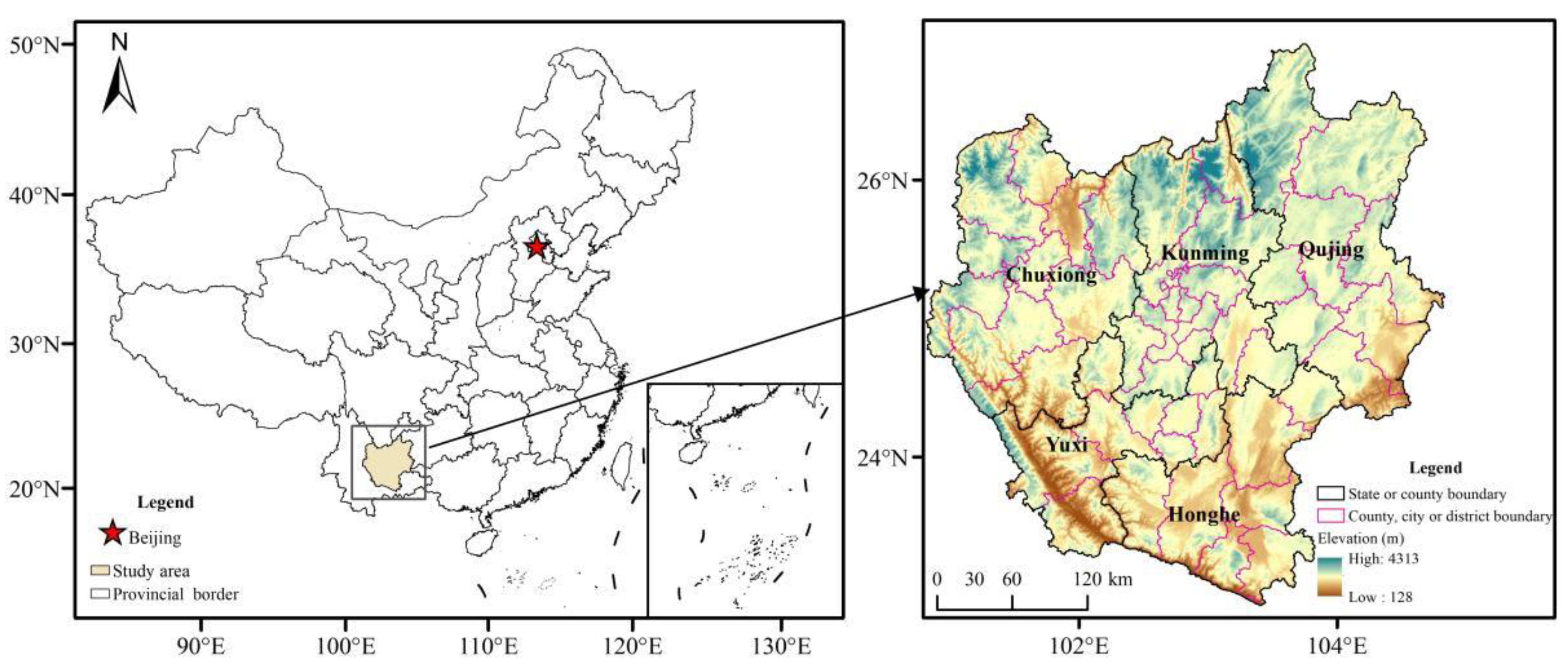
2.1. Study Area
2.2. Data Sources
2.3. Methodological Steps
2.3.1. Land Use Change Measurement
- (1)
- The land use dynamics degree. It can quantitatively describe the quantity change in a certain land use type at a certain time. The land use change process across the study area can be observed by calculating the dynamic degree of every land use type, using the following calculation formula:where D represents the dynamic attitude in land type ith, suggests the area in land type i at the latter moment, means the area in land type i at the initial moment, refers to the time interval, and if the time interval is measured in years then D denotes the average annual change rate in land type i.
- (2)
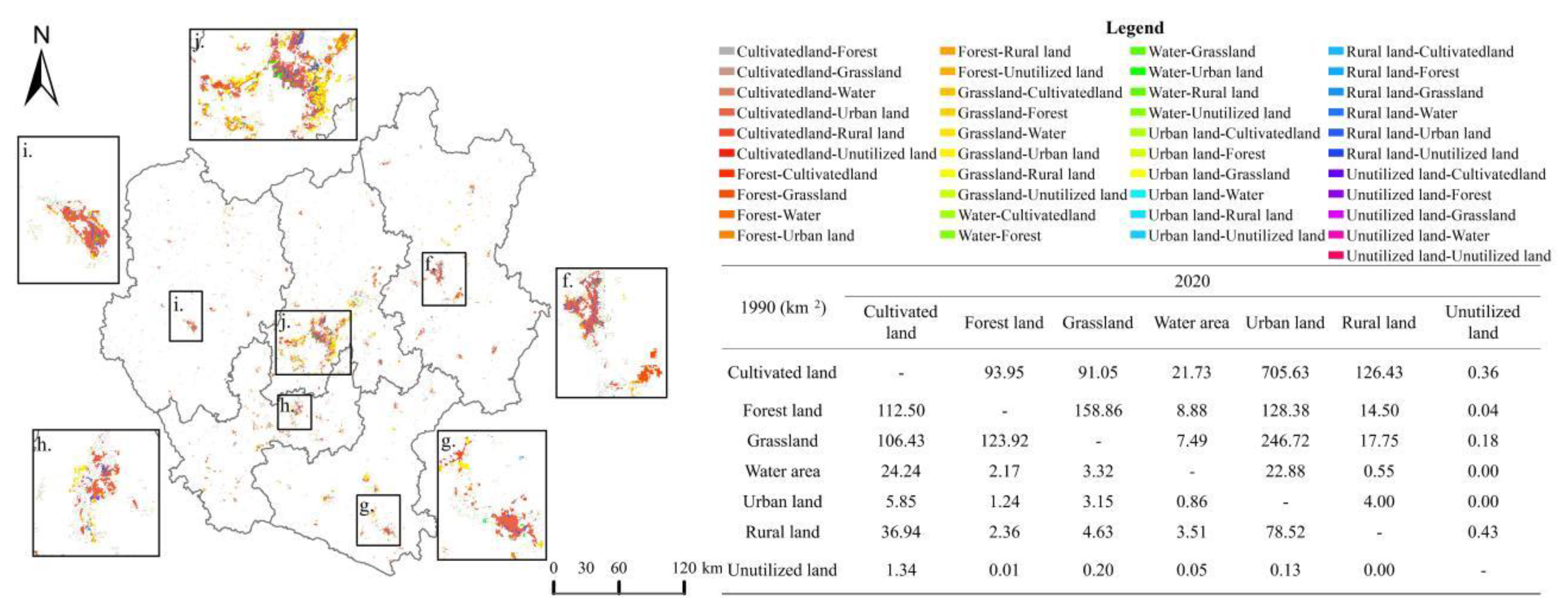
- Land use type transfer. The land use data across the study area was calculated by two-by-two superposition through the raster calculation in ArcGIS 10.8 to conclude the land use type transfer and spatial distribution across the study area in two phases with the following formula:where refers to the land use change from period A to period B, and and are the land use types of any two periods.
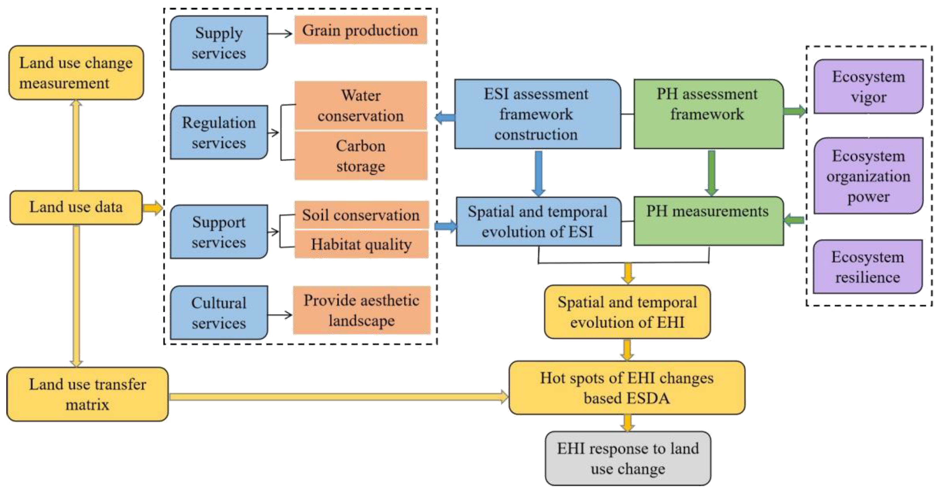
2.3.2. Ecosystem Health Assessment Framework
2.3.3. Selection and Assessment of Integrated Ecosystem Service Indicators
2.3.4. Ecosystem Physical Health Indicator Selection and Assessment
2.3.5. Hot Spots Analysis
2.3.6. Measuring the Impact of Land Use Change on Ecosystem Health Hot Spots Analysis
3. Results
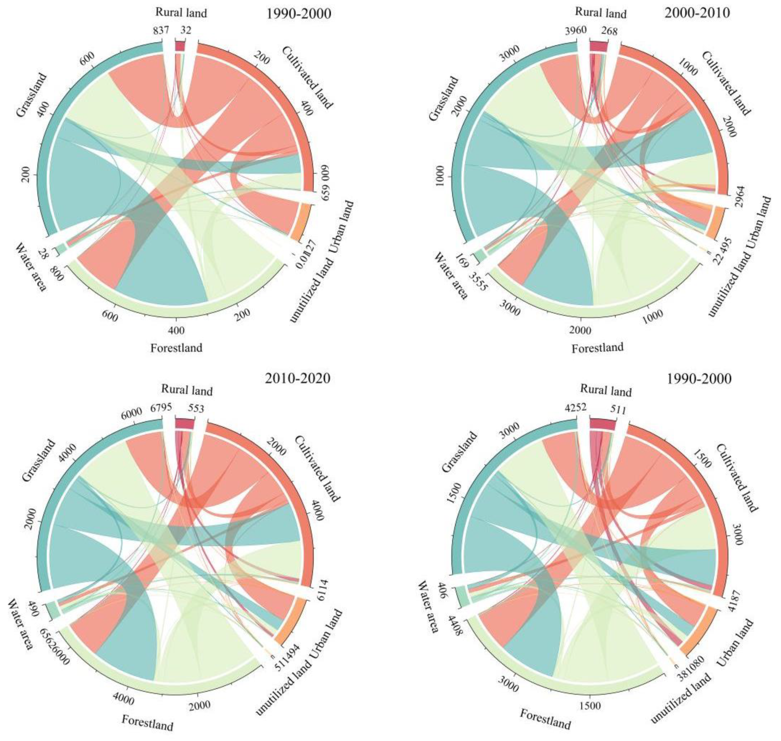
3.1. Characteristics of Land Use Change in the Central Yunnan Urban Agglomeration
3.2. Spatial and Temporal Evolutionary Features of Ecosystem Service Functions of the Central Yunnan Urban Agglomeration
3.3. Spatial and Temporal Evolutionary Characteristics of Ecosystem Health in the Central Yunnan Urban Agglomeration
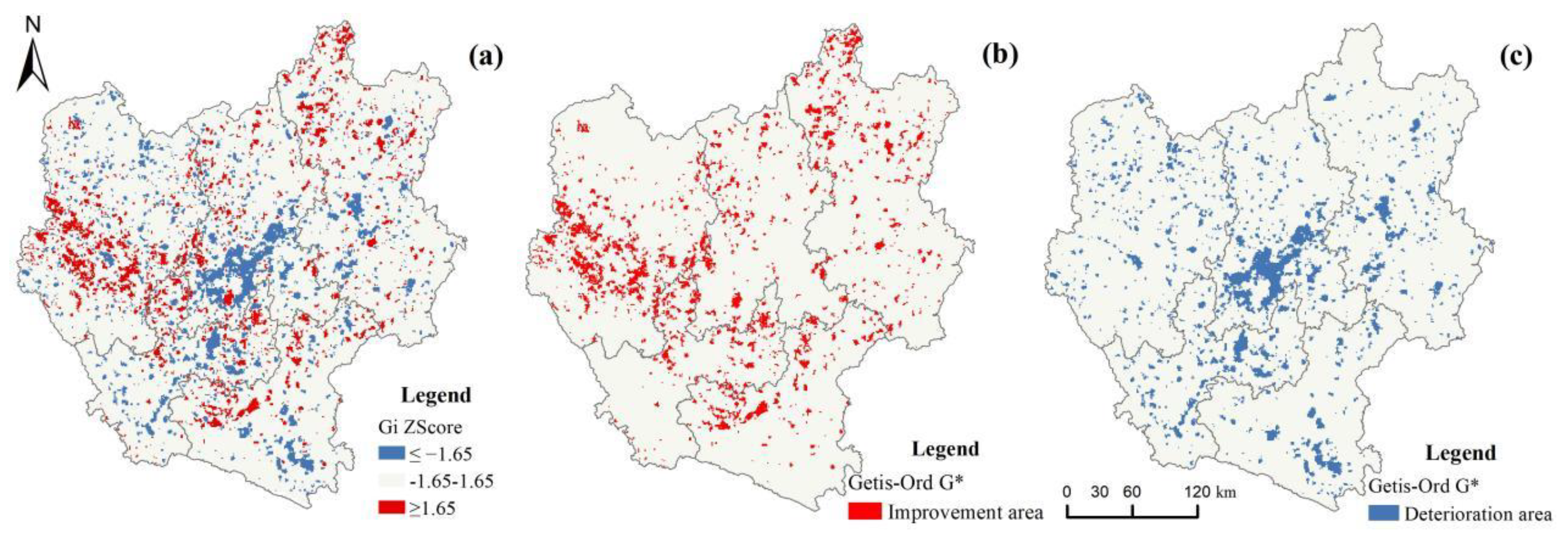
3.4. Effects of Land Use Change on the Ecosystem Health of the Central Yunnan Urban Agglomeration
4. Discussion
4.1. Interpretation of Land Use Changes in Central Yunnan Urban Agglomeration
4.2. Ecosystem Health Level Analysis
4.3. Relationship between Land Use Change and Ecosystem Health
4.4. Limitations and Future Research
5. Conclusions
- (1)
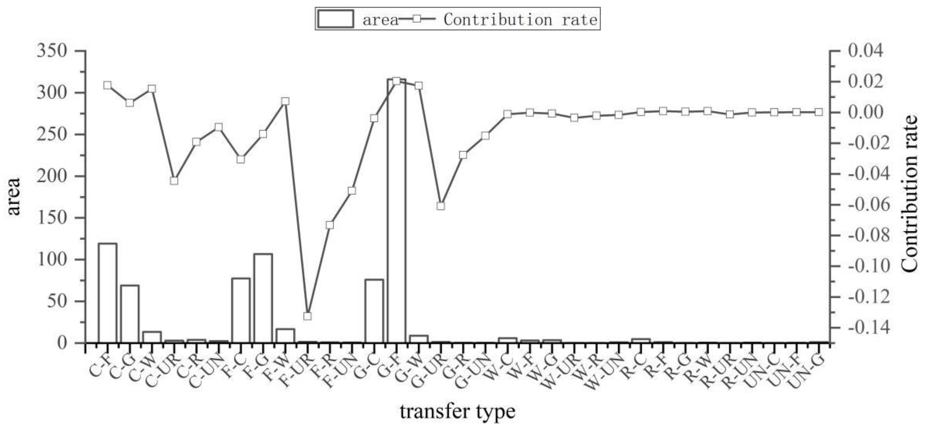
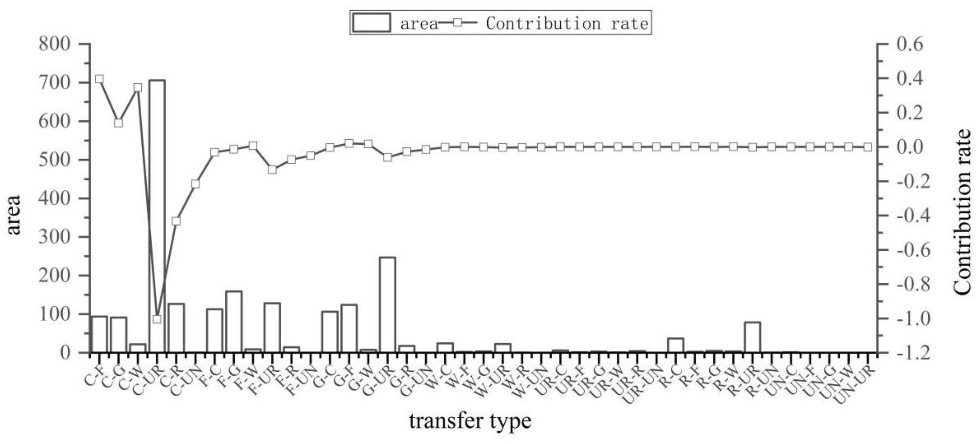
- Forest land was the predominant land use type during the study period. The transformation of cultivated and grassland to urban land is the most significant in the process of land type transformation. The rapid expansion of urban land became the most important factor in disrupting the overall land use structure change in the study area.
- (2)
- The spatial variability of ecosystem health level is significant, with the central and eastern regions being worse and the western regions being relatively good. The areas with the lowest levels of ecosystem health are urban development areas.
- (3)
- Ecosystem health is influenced by land use shifts. The improvement of health levels is closely related to the mutual transfer between forest land and grassland, and the conversion from cultivated land to forest land. The fast expansion of urban land caused by urbanization and the conversion from cultivated land and grassland to urban land are important reasons for the deterioration of ecosystem health.
Supplementary Materials
Author Contributions
Funding
Institutional Review Board Statement
Informed Consent Statement
Data Availability Statement
Conflicts of Interest
References
- Fang, C.; Yu, D. Urban agglomeration: An evolving concept of an emerging phenomenon. Landsc. Urban Plan. 2017, 162, 126–136. [Google Scholar] [CrossRef]
- He, Y.; Lin, Y.; Zhou, G.; Zhu, Y.; Tang, K. Spatial pattern and drivers of urbanization in china’s mid-level developing urban agglomeration: A case study of chang-zhu-tan. Reg. Sustain. 2021, 2, 83–97. [Google Scholar] [CrossRef]
- Wang, Z.; Liang, L.; Sun, Z.; Wang, X. Spatiotemporal differentiation and the factors influencing urbanization and ecological environment synergistic effects within the beijing-tianjin-hebei urban agglomeration. J. Environ. Manag. 2019, 243, 227–239. [Google Scholar] [CrossRef] [PubMed]
- Fang, C.; Zhou, C.; Gu, C.; Chen, L.; Li, S. A proposal for the theoretical analysis of the interactive coupled effects between urbanization and the eco-environment in mega-urban agglomerations. J. Geogr. Sci. 2017, 27, 1431–1449. [Google Scholar] [CrossRef]
- Patra, S.; Sahoo, S.; Mishra, P.; Mahapatra, S.C. Impacts of urbanization on land use/cover changses and its probable implications on local climate and groundwater level. J. Urban Manag. 2018, 7, 70–84. [Google Scholar] [CrossRef]
- Sharma, S.; Nahid, S.; Sharma, M.; Sannigrahi, S.; Anees, M.M.; Sharma, R.; Shekhar, R.; Basu, A.S.; Pilla, F.; Basu, B.; et al. A long-term and comprehensive assessment of urbanization-induced impacts on ecosystem services in the capital city of india. City Environ. Interact. 2020, 7, 100047. [Google Scholar] [CrossRef]
- Peng, J.; Liu, Y.; Li, T.; Wu, J. Regional ecosystem health response to rural land use change: A case study in lijiang city, china. Ecol. Indic. 2017, 72, 399–410. [Google Scholar] [CrossRef]
- He, J.; Shi, X.; Fu, Y.; Yuan, Y. Evaluation and simulation of the impact of land use change on ecosystem services trade-offs in ecological restoration areas, china. Land Use Policy 2020, 99, 105020. [Google Scholar] [CrossRef]
- Li, B.; Shi, X.; Chen, Y.; Jiang, Y. Quantitative assessment of the ecological effects of land use/cover change in the arid region of northwest china. Environ. Monit Assess 2019, 191, 704. [Google Scholar] [CrossRef]
- Rapport, D.J. What constitutes ecosystem health? Perspect. Biol. Med. 1989, 33, 120–132. [Google Scholar] [CrossRef]
- Costanza, R. Ecosystem health and ecological engineering. Ecol. Eng. 2012, 45, 24–29. [Google Scholar] [CrossRef]
- He, J.; Pan, Z.; Liu, D.; Guo, X. Exploring the regional differences of ecosystem health and its driving factors in china. Sci. Total Environ. 2019, 673, 553–564. [Google Scholar] [CrossRef] [PubMed]
- Rapport, D.J.; Costanza, R.; McMichael, A.J. Assessing ecosystem health. Trends Ecol. Evol. 1998, 13, 397–402. [Google Scholar] [CrossRef]
- Liu, Y.; Peng, J.; Wan, A.; Xie, P.; Han, Y. New research progress and trends in ecosystem health. Acta Ecol. Sin. 2015, 35, 5920–5930. [Google Scholar]
- Ma, K.; Kong, H.; Guan, W.; Fu, B. Ecosystem health assessment:Methods and directions. Acta Ecol. Sin. 2001, 21, 2106–2116. [Google Scholar]
- Xie, X.; Pu, L. Assessment of urban ecosystem health based on matter element analysis: A case study of 13 cities in jiangsu province, china. Int. J. Environ. Res. Public Health 2017, 14, 940. [Google Scholar] [CrossRef]
- Meng, L.; Huang, J.; Dong, J. Assessment of rural ecosystem health and type classification in jiangsu province, china. Sci. Total Environ. 2018, 615, 1218–1228. [Google Scholar] [CrossRef]
- Sun, J.; Li, Y.P.; Gao, P.P.; Xia, B.C. A mamdani fuzzy inference approach for assessing ecological security in the pearl river delta urban agglomeration, china. Ecol. Indic. 2018, 94, 386–396. [Google Scholar] [CrossRef]
- Wang, Q.; Li, S.; Li, R. Evaluating water resource sustainability in beijing, china: Combining psr model and matter-element extension method. J. Clean. Prod. 2019, 206, 171–179. [Google Scholar] [CrossRef]
- Xue, L.; Wang, J.; Zhang, L.; Wei, G.; Zhu, B. Spatiotemporal analysis of ecological vulnerability and management in the tarim river basin, china. Sci. Total Environ. 2019, 649, 876–888. [Google Scholar] [CrossRef]
- Costanza, R. Toward an Operational Definition of Ecosystem Health. In Ecosystem Health: New Goals for Environmental Management; Island Press: Washington, DC, USA, 1992; pp. 239–256. [Google Scholar]
- Kang, P.; Chen, W.; Hou, Y.; Li, Y. Linking ecosystem services and ecosystem health to ecological risk assessment: A case study of the beijing-tianjin-hebei urban agglomeration. Sci. Total Environ. 2018, 636, 1442–1454. [Google Scholar] [CrossRef] [PubMed]
- Peng, J.; Liu, Y.; Wu, J.; Lv, H.; Hu, X. Linking ecosystem services and landscape patterns to assess urban ecosystem health: A case study in shenzhen city, china. Landsc. Urban Plan. 2015, 143, 56–68. [Google Scholar] [CrossRef]
- Xiao, Y.; Guo, L.; Sang, W. Impact of fast urbanization on ecosystem health in mountainous regions of southwest china. Int. J. Environ. Res. Public Health 2020, 17, 826. [Google Scholar] [CrossRef] [PubMed]
- Ge, F.; Tang, G.; Zhong, M.; Zhang, Y.; Xiao, J.; Li, J.; Ge, F. Assessment of ecosystem health and its key determinants in the middle reaches of the yangtze river urban agglomeration, china. Int. J. Environ. Res. Public Health 2022, 19, 771. [Google Scholar] [CrossRef]
- Xu, D.; Cai, Z.; Xu, D.; Lin, W.; Gao, J.; Li, L. Land use change and ecosystem health assessment on shanghai–hangzhou bay, eastern china. Land 2022, 11, 867. [Google Scholar] [CrossRef]
- Wang, Z.; Liu, Y.; Li, Y.; Su, Y. Response of ecosystem health to land use changes and landscape patterns in the karst mountainous regions of southwest china. Int. J. Environ. Res. Public Health 2022, 19, 3273. [Google Scholar] [CrossRef]
- Chen, P. Monthly npp dataset covering china’s terrestrial ecosystems at north of 18°n (1985–2015). J. Glob. Chang. Data Discov. 2019, 3, 34–41. [Google Scholar] [CrossRef]
- Costanza, R.; d’Arge, R.; de Groot, R.; Farber, S.; Grasso, M.; Hannon, B.; Limburg, K.; Naeem, S.; Robert, V.O.; Paruelo, J.; et al. The value of the world’s ecosystem services and natural capital. Nature 1997, 387, 253–260. [Google Scholar] [CrossRef]
- Chen, W.; Zhao, X.; Zhong, M.; Li, J.; Zeng, J. Spatiotemporal evolution patterns of ecosystem health in the middle reaches of the yangtze river urban agglomerations. Acta Ecol. Sin. 2022, 42, 138–149. [Google Scholar] [CrossRef]
- Peng, J.; Wang, Y.; Wu, J.; Zhang, Y. Evaluation for regional ecosystem health: Methodology and research progress. Acta Ecol. Sin. 2007, 27, 4877–4885. [Google Scholar] [CrossRef]
- Pan, J.; Wang, Y. Ecological security evaluation and ecological pattern optimization in taolai river basin based on cvor and circuit theory. Acta Ecol. Sin. 2021, 41, 2582–2595. [Google Scholar]
- Millennium ecosystem assessment. Ecosystems and Human Well-Being: Biodiversity Synthesis; Island Press: Washington, DC, USA, 2005. [Google Scholar]
- Zhao, X.; Du, Y.; Li, H.; Wang, W. Spatio-temporal changes of the coupling relationship between urbanization and ecosystem services in the middle yellow river. J. Nat. Resour. 2021, 36, 131–147. [Google Scholar] [CrossRef]
- Qiu, W.; Zhang, Y.; Yu, J.; Zhang, C.; Zheng, C.; Yu, S. Feasibility verification with field application of a water conservation module using the invest model. J. Zhejiang AF Univ. 2018, 35, 810–817. [Google Scholar] [CrossRef]
- Liu, Y.; Liu, X.; Zhang, B.; Li, M. Spatial features analysis of water conservation function in the hilly areas of the loess plateau based on invest model. Acta Ecol. Sin. 2020, 40, 6161–6170. [Google Scholar]
- Xie, G.; Zhang, C.; Zhang, L.; Chen, W.; Li, S. Improvement of the evaluation method for ecosystem service value based on per unit area. J. Nat. Resour. 2015, 30, 1243–1254. [Google Scholar] [CrossRef]
- Das, M.; Das, A.; Pereira, P.; Mandal, A. Exploring the spatio-temporal dynamics of ecosystem health: A study on a rapidly urbanizing metropolitan area of lower gangetic plain, india. Ecol. Indic. 2021, 125, 107584. [Google Scholar] [CrossRef]
- Zheng, K.; Li, C.; Wu, Y.; Gao, B.; Wu, Y.; Li, C. Spatio-temporal evolution of habitat quality and its influencing factors in ecological conservation area in sichuan-yunnan provinces based on value assessment. J. Ecol. Rural Environ. 2022. accepted. [Google Scholar] [CrossRef]
- Peng, J.; Xu, F. Effect of grid size on habitat quality assessment: A case study of huangshan city. J. Geo-Inf. Sci. 2019, 21, 887–897. [Google Scholar] [CrossRef]
- Shi, Y.; Shi, D.; Zhou, L.; Fang, R. Identification of ecosystem services supply and demand areas and simulation of ecosystem service flows in shanghai. Ecol. Indic. 2020, 115, 106418. [Google Scholar] [CrossRef]
- Li, C.; Wu, Y.; Gao, B.; Zheng, K.; Wu, Y.; Li, C. Multi-scenario simulation of ecosystem service value for optimization of land use in the sichuan-yunnan ecological barrier, china. Ecol. Indic. 2021, 132, 108328. [Google Scholar] [CrossRef]
- Chen, Y.; Wang, J.; Xiong, N.; Sun, L.; Xu, J. Impacts of land use changes on net primary productivity in urban agglomerations under multi-scenarios simulation. Remote Sens. 2022, 14, 1755. [Google Scholar] [CrossRef]
- Guo, C.; Gao, S.; Zhou, B.; Gao, J. Effects of land use change on ecosystem service value in funiu mountain based upon a grid square. Acta Ecol. Sin. 2019, 39, 3482–3493. [Google Scholar]
- Cui, G.; Zhang, Y.; Chao, Y.; Zhao, Y.; Pan, B. Land use change and eco-environmental effects in qinling mountains in recent 40 years. Res. Soil Water Conserv. 2023, 30. accepted. [Google Scholar] [CrossRef]
- Lu, X.; Ke, S. Evaluating the effectiveness of sustainable urban land use in china from the perspective of sustainable urbanization. Habitat Int. 2018, 77, 90–98. [Google Scholar] [CrossRef]
- Yang, Y.; Jun, Z.; Sui, X.; He, X. Study of the spatial connection between urbanization and the ecosystem-a case study of central yunnan (China). PLoS ONE 2020, 15, e0238192. [Google Scholar] [CrossRef] [PubMed]
- Shu, H.; Xiao, C.; Ma, T.; Sang, W. Ecological health assessment of chinese national parks based on landscape pattern: A case study in shennongjia national park. Int. J. Environ. Res. Public Health 2021, 18, 11487. [Google Scholar] [CrossRef]
- Zank, B.; Bagstad, K.J.; Voigt, B.; Villa, F. Modeling the effects of urban expansion on natural capital stocks and ecosystem service flows: A case study in the puget sound, washington, USA. Landsc. Urban Plan. 2016, 149, 31–42. [Google Scholar] [CrossRef]
- Anaya-Romero, M.; Muñoz-Rojas, M.; Ibáñez, B.; Marañón, T. Evaluation of forest ecosystem services in mediterranean areas. A regional case study in south spain. Ecosyst. Serv. 2016, 20, 82–90. [Google Scholar] [CrossRef]
- Tolessa, T.; Senbeta, F.; Kidane, M. The impact of land use/land cover change on ecosystem services in the central highlands of ethiopia. Ecosyst. Serv. 2017, 23, 47–54. [Google Scholar] [CrossRef]
- The People’s Government of Yunnan Province. Development Plan of Central Yunnan Urban Agglomerate. 2020. Available online: http://www.yn.gov.cn (accessed on 25 January 2022).
- Liu, C.; Deng, C.; Li, Z.; Liu, Y.; Wang, S. Optimization of spatial pattern of land use: Progress, frontiers, and prospects. Int. J. Environ. Res. Public Health 2022, 19, 5805. [Google Scholar] [CrossRef]
- Wang, X.; Meng, J. Research progress on the environmental-ecological impacts of land use change. Acta Sci. Nat. Univ. Pekin. 2014, 50, 1133–1140. [Google Scholar] [CrossRef]



| Data Type | Data Sources |
|---|---|
| Land use data | Resource and Environmental Science Data Center of the Chinese Academy of Sciences (https://www.resdc.cn/) (accessed on 6 October 2021). |
| Elevation data | Geospatial Data Cloud Platform (http://www.gscloud.cn) (accessed on 6 October 2021). |
| Precipitation data | National Earth System Science Data Center (http://www.geodata.cn) (accessed on 25 January 2022). |
| Potential evapotranspiration | National Earth System Science Data Center (http://www.geodata.cn) (accessed on 25 January 2022). |
| Soil depth | World Soil Database (HWSD) China Soil Dataset (v1.1) (http://www.cryosphere.csdb.cn) (accessed on 25 January 2022). |
| Normalized vegetation index (NDVI) | The NDVI data in 2000, 2010 and 2020 were generated based on the MODIS vegetation index products with a spatial resolution of 250 × 250 m and a 16-day temporal resolution obtained by the NASA Earth Observation System, using the annual maximum synthesis method. The NDVI data in 1990 was obtained from the national Earth System Science Data Center. |
| Net Primary Productivity (NPP) | The spatial resolution of the MODIS data product is 500 m, the band is cut and stitched, and the pixel value is multiplied by a scale factor of 0.0001 to calculate. The 1990 NPP data was gathered from Chen Pengfei, “Monthly net primary productivity 1 km raster dataset of Chinese terrestrial ecosystems north of 18° N (1985–2015)” [J/DB/OL]. Electronic Journal of Global Change Data Warehousing, 2019 [28]. (http://www.geodoi.ac.cn/) (accessed on 23 December 2021). |
| Grain production and sown area | According to“Yunnan Provincial Statistical Yearbook” to obtain the grain production and sown area of 49 (district) counties in each year. |
| Grain prices | National compilation of agricultural cost-benefit information. |
| Ecosystem Services | Ecosystem Functions | Fundamentals | Measurement Formula |
|---|---|---|---|
| Supply Services | Grain Production | Based on the linear correlation between grain yield and NDVI, grain yield was assigned according to the ratio of raster NDVI values to total NDVI values of cultivated land based on land use type [34]. | where Gi is the grain yield of arable raster i, Gsum suggests the total grain yield in the study unit, NDVIi means the NDVI value for arable raster i, and NDVIsum indicates the sum of NDVI values in the study unit. |
| Regulation Services | Water Conservation | According to the water cycle principle, the water yield is obtained by calculating parameters, including precipitation, plant transpiration, surface evaporation, root depth as well as soil depth [35]. Afterward the runoff path topography index is measured using the DEM and the runoff residence time on the grate is measured with soil permeability and surface runoff flow coefficient. The water yield is corrected to obtain the water content [36]. | (1) where Retention means the water content (mm); Velocity refers to the flow rate coefficient; TI denotes the topographic index measured using Equation (2); Ksat indicates the soil saturation hydraulic conductivity (cm/d), measured with Equation (3); Yield denotes the water yield, measured using Equation (4). (2) where Drainage_Area represents the number of grids of the catchment area (dimensionless); Soil_Depth suggests the soil depth (mm); Percent_Slope indicates the percentage slope. (3) where Ksat denotes soil saturated hydraulic conductivity (cm/d), Clay indicates soil clay content (%), Sand represents soil sand content (%), OC refers to soil organic carbon content (%), BD means soil bulk weight (g/cm3). (4) where Yjx represents the annual water yield; Px means the average annual rainfall in raster cell x; AETxj refers to the average annual evapotranspiration in raster cell x in land use type j. |
| Carbon Storage | The average carbon density for above-ground carbon pool, below-ground carbon pool, soil carbon pool and dead organic carbon pool were calculated separately for different land types and were summed by multiplying the area in every land type by the corresponding carbon density. | where Ci is the ith land use type; Ci,above signifies the above-ground carbon density in land use type i (t/hm2); Ci,below suggests the below-ground biological carbon density in land use type i (t/hm2); Ci,soil signifies the soil carbon density in land use type i (t/hm2); Ci,dead denotes the carbon density of dead organic matter in land use type i (t/hm2), Ctotal means the total carbon stock in the ecosystem (t); Si indicates the area in land use type i (hm2); n denotes the number of land use types, and n is 7 in this paper. | |
| Support Services | Soil Conservation | Soil retention is obtained by measuring the difference between potential erosion and real erosion and adding it to the sediment holding capacity. | where SMx means the soil retention of raster x, SDRx means the sediment retention for raster x, and SEx represents the sediment retention efficiency for raster x. PKLSx suggests the potential soil loss for raster x, and USLEx and USLEy stand for the real erosion of raster x and its upslope raster y, i.e., soil erosion under vegetation cover and soil and water conservation measures, respectively. Rx, Kx, LSx, Cx, and Px denote the rainfall erosion force factor, soil erodibility factor, topography factor, vegetation cover factor, and soil and water conservation measure factor for raster x, respectively. |
| Habitat Quality | Generate habitat quality maps by the Habitat Quality module under the InVEST model, combining information on land cover and biodiversity threat factors. | where Qxj means the habitat quality index for raster x in land use type j; Hj suggests the habitat suitability in land use type j, with the value set to [0, 1]; Dxj indicates the degradation of habitat for raster x in land use type j; k signifies the half-saturation constant, which takes half of the maximum degradation 0.056 (system default 0.5). | |
| Cultural Services | Provide Aesthetic Landscape | The sown area, yield, and average price for three main crops (rice, wheat, and corn) in 49 (district) counties were used as the base data to calculate the economic value of crops per unit area. Combined with the base equivalence table of ecosystem services per unit area in the research by Xie et al. [37], the ecosystem service values of aesthetic landscapes were calculated and expressed spatially based on grid division. | where E is the economic value of crop production per unit area of the study area; i means the crop type; Oi, Pi and Qi represent the sown area, yield per unit area and average price of i crops, respectively; M is the total area of three crops (rice, wheat, and corn) of the study area. where ESV refers to the ecosystem service value of aesthetic landscape; Ai means the area in land type ith; VCi represents the ESV coefficient of the aesthetic landscape in land type ith. |
| Type of Land Use | Cultivated Land | Forest Land | Grassland | Water Area | Urban Land | Rural Land | Unutilized Land |
|---|---|---|---|---|---|---|---|
| Ecosystem resilience | 0.4 | 0.6 | 0.8 | 0.7 | 0.2 | 0.5 | 1 |
| Ecosystem resistance | 0.6 | 1 | 0.7 | 0.5 | 0.3 | 0.4 | 0.2 |
| Type of Land Use | 1900 | 2000 | 2010 | 2020 | ||||
|---|---|---|---|---|---|---|---|---|
| Area (km2) | Proportion (%) | Area (km2) | Proportion (%) | Area (km2) | Proportion (%) | Area (km2) | Proportion (%) | |
| cultivated land | 23,442.81 | 21.05 | 23,041.63 | 20.69 | 22,963.36 | 20.62 | 22,528.40 | 20.23 |
| forest land | 54,721.12 | 49.14 | 54,945.99 | 49.34 | 54,857.48 | 49.26 | 54,649.97 | 49.08 |
| grassland | 30,625.01 | 27.50 | 30,633.62 | 27.51 | 30,331.00 | 27.24 | 29,893.95 | 26.85 |
| water area | 1282.37 | 1.15 | 1294.87 | 1.16 | 1326.63 | 1.19 | 1461.55 | 1.31 |
| urban land | 284.97 | 0.26 | 411.78 | 0.37 | 739.61 | 0.66 | 1726.02 | 1.55 |
| rural land | 844.17 | 0.76 | 872.45 | 0.78 | 976.49 | 0.88 | 935.60 | 0.84 |
| unutilized land | 155.59 | 0.14 | 155.58 | 0.14 | 161.47 | 0.15 | 160.54 | 0.14 |
| Ecosystem Health Rating | 1990 | 2000 | 2010 | 2020 | 1990–2000 | 2000–2010 | 2010–2020 | 1990–2020 |
|---|---|---|---|---|---|---|---|---|
| Weak | 0.68% | 4.83% | 4.25% | 4.59% | 4.15% | −0.59% | 0.34% | 3.91% |
| Relative weak | 17.01% | 11.42% | 11.26% | 9.85% | −5.59% | −0.16% | −1.14% | −7.16% |
| Ordinary | 29.70% | 27.38% | 26.31% | 24.09% | −2.32% | −1.07% | −2.23% | −5.61% |
| Relatively well | 33.65% | 23.13% | 24.93% | 23.12% | −10.52% | 1.81% | −1.81% | −10.53% |
| Well | 18.96% | 33.24% | 33.25% | 38.35% | 14.27% | 0.01% | 5.11% | 19.39% |
Publisher’s Note: MDPI stays neutral with regard to jurisdictional claims in published maps and institutional affiliations. |
© 2022 by the authors. Licensee MDPI, Basel, Switzerland. This article is an open access article distributed under the terms and conditions of the Creative Commons Attribution (CC BY) license (https://creativecommons.org/licenses/by/4.0/).
Share and Cite
Gao, B.; Wu, Y.; Li, C.; Zheng, K.; Wu, Y. Ecosystem Health Responses of Urban Agglomerations in Central Yunnan Based on Land Use Change. Int. J. Environ. Res. Public Health 2022, 19, 12399. https://doi.org/10.3390/ijerph191912399
Gao B, Wu Y, Li C, Zheng K, Wu Y. Ecosystem Health Responses of Urban Agglomerations in Central Yunnan Based on Land Use Change. International Journal of Environmental Research and Public Health. 2022; 19(19):12399. https://doi.org/10.3390/ijerph191912399
Chicago/Turabian StyleGao, Binpin, Yingmei Wu, Chen Li, Kejun Zheng, and Yan Wu. 2022. "Ecosystem Health Responses of Urban Agglomerations in Central Yunnan Based on Land Use Change" International Journal of Environmental Research and Public Health 19, no. 19: 12399. https://doi.org/10.3390/ijerph191912399
APA StyleGao, B., Wu, Y., Li, C., Zheng, K., & Wu, Y. (2022). Ecosystem Health Responses of Urban Agglomerations in Central Yunnan Based on Land Use Change. International Journal of Environmental Research and Public Health, 19(19), 12399. https://doi.org/10.3390/ijerph191912399


