
Evaluation and Optimization Model of Rural Settlement Habitability in the Upper Reaches of the Minjiang River, China
 ,
,
Abstract
:1. Introduction
2. Materials and Methods
2.1. Study Area
2.2. Research Data
2.3. Research Framework and Index System
2.3.1. Research Framework
2.3.2. Evaluation Index System of Rural Settlement Livability
2.4. Methods
2.4.1. Kernel Densitometry Analysis
2.4.2. Degree of Topographic Relief
2.4.3. Per Capita Land Area and Density of Water and Road Network
2.4.4. Meteorological Indices
2.4.5. Resistance Value of Accessibility
2.4.6. Index Weight
3. Results
3.1. Livability Zoning
3.2. Livability Analysis of Rural Settlements
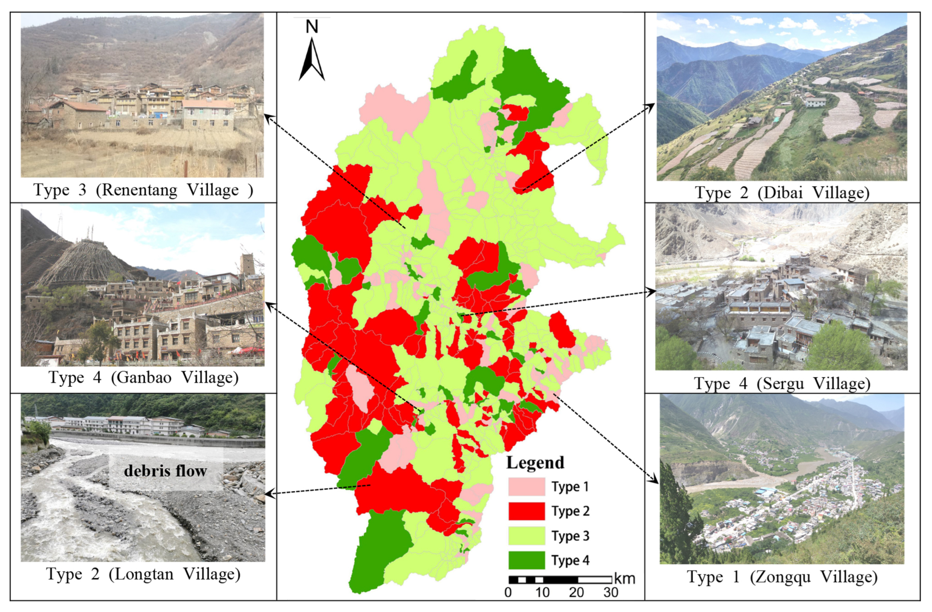
3.3. Optimization Model of Rural Settlements Livability
4. Discussion
5. Conclusions
- (1)
- In terms of individual livability, the upper reaches of the Minjiang river are prone to geological hazards and underdeveloped, and the site safety, resource endowment and economic affluence in the region are generally poor, while the environmental suitability and convenience of living are relatively good. The overall livability of the area is significantly better and the main factors affecting the livability are site security and economic prosperity.
- (2)
- In terms of the livability of rural settlements, the location of rural settlements was highly livability-oriented and the area of rural settlements in the study area decrease with the livability index, and the moderately and highly suitable areas are the core areas of human settlements.
- (3)
- Based on the results of the livability evaluation and field research, we summarize the problems faced by the livability improvement and propose four optimization models for the livability improvement of rural settlements based on the four optimization goals of development synergy, disaster management, industrial upgrading and cultural preservation.
Author Contributions
Funding
Institutional Review Board Statement
Informed Consent Statement
Data Availability Statement
Acknowledgments
Conflicts of Interest
References
- Liu, Y.S.; Li, Y.H. Revitalize the world’s countryside. Nature 2017, 548, 275–277. [Google Scholar] [CrossRef] [PubMed] [Green Version]
- Zhao, W.; Jiang, C.J. Analysis of the Spatial and Temporal Characteristics and Dynamic Effects of Urban-Rural Integration Development in the Yangtze River Delta Region. Land 2022, 11, 1054. [Google Scholar] [CrossRef]
- Bennett, K.J.; Yuen, M.; Blanco-Silva, F. Geographic differences in recovery after the Great Recession. J. Rural. Stud. 2018, 59, 111–117. [Google Scholar] [CrossRef]
- Liu, Y.S. Research on the Urban-rural Integration and Rural Revitalization in the New Era in China. Acta Geogr. Sin. 2018, 73, 637–650. [Google Scholar]
- Anthopoulou, T.; Kaberis, N.; Petrou, M. Aspects and experiences of crisis in rural Greece. Narratives of rural resilience. J. Rural. Stud. 2017, 52, 1–11. [Google Scholar] [CrossRef]
- Wang, Y.; Zhu, Y.M.; Yu, M.J. Evaluation and determinants of satisfaction with rural livability in China’s less-developed eastern areas: A case study of Xianju County in Zhejiang Province. Ecol. Indic. 2019, 104, 711–722. [Google Scholar] [CrossRef]
- Parker, J.; Simpson, G.D. Public Green Infrastructure Contributes to City Livability: A Systematic Quantitative Review. Land 2018, 7, 161. [Google Scholar] [CrossRef] [Green Version]
- Dong, X.Y.; Hu, Z.W.; Wu, J.J.; Wang, J.Z.; Yang, C.; Zhang, J.; Xia, J.Z.; Wu, G.F. Evaluation of Ecological Livability of Dwelling Area based on Multi-source Data: A Case Study of Shenzhen City. Acta Ecol. Sin. 2022, 42, 1–13. [Google Scholar]
- Kovacs-Gyori, A.; Cabrera-Barona, P.; Resch, B.; Mehaffy, M.; Blaschke, T. Assessing and Representing Livability through the Analysis of Residential Preference. Sustainability 2019, 11, 4934. [Google Scholar] [CrossRef] [Green Version]
- Krajnc, D.; Glavic, P. A model for integrated assessment of sustainable development. Resour. Conserv. Recycl. 2005, 43, 189–208. [Google Scholar] [CrossRef]
- Huang, A.; Xu, Y.Q.; Liu, C.; Hao, J.M.; Sun, P.L.; Zheng, W.R.; Lu, L.H. Evaluation on livability of living space based on multiple functions of land use at county level. Trans. Chin. Soc. Agric. Eng. 2018, 34, 252–261. [Google Scholar]
- Zheng, D.W.; Ruan, P.N. General Conception of Livable City Basing on ANP. Urban Stud. 2007, 14, 6–12. [Google Scholar]
- Asami, Y. Residential Environment: Methods and Theory for Evaluation; University of Tokyo Press: Tokyo, Japan, 2001. [Google Scholar]
- Zhang, W.Z. Index System and Method of Residential Environmental Evaluation in Inner Cities. Sci. Geogr. Sin. 2007, 27, 17–23. [Google Scholar]
- Wang, Y.; Miao, Z.Y.; Lu, Y.Q.; Zhu, Y.M. The impact of economic development on urban livability: Evidence from 40 large and medium-sized cities of China. Acta Geogr. Sin. 2022, 77, 2529–2546. [Google Scholar]
- Huang, X.; Liu, Y. Livability assessment of 101,630 communities in China’s major cities: A remote sensing perspective. Sci. China Earth Sci. 2022, 52, 1283–1298. [Google Scholar] [CrossRef] [PubMed]
- Tang, N.; Wang, C.; Du, X.Z. Evaluation of Rural Human Settlements Quality and Its Differentiated Optimization in Chongqing Municipality. Econ. Geogr. 2018, 38, 160. [Google Scholar]
- Ye, Q.Q.; Li, J.W.; Kong, X.S.; Zhang, S.K. Identification and Optimization of the Spatial Structure of Urban and Rural Settlements from a Hierarchical Network Perspective. Land 2021, 10, 1177. [Google Scholar] [CrossRef]
- Li, H.B.; Yuan, Y.; Zhang, X.L.; Li, Z.; Wang, Y.H.; Hu, X.L. Evolution and transformation mechanism of the spatial structure of rural settlements from the perspective of long-term economic and social change: A case study of the Sunan region, China. J. Rural. Stud. 2022, 93, 234–243. [Google Scholar] [CrossRef]
- Tang, C.L.; He, Y.H.; Zhou, G.H.; Zeng, S.S.; Xiao, L.Y. Optimizing the spatial organization of rural settlements based on life quality. J. Geogr. Sci. 2018, 28, 685–704. [Google Scholar] [CrossRef] [Green Version]
- Lu, M.Q.; Wei, L.Y.; Ge, D.Z.; Sun, D.Q.; Zhang, Z.F.; Lu, Y.Q. Spatial optimization of rural settlements based on the perspective of appropriateness-domination: A case of Xinyi City. Habitat Int. 2020, 98, 12. [Google Scholar] [CrossRef]
- Tu, S.S.; Long, H.L.; Zhang, Y.N.; Ge, D.Z.; Qu, Y. Rural restructuring at village level under rapid urbanization in metropolitan suburbs of China and its implications for innovations in land use policy. Habitat Int. 2018, 77, 143–152. [Google Scholar] [CrossRef]
- Xu, J.; Ma, H.T.; Luo, J.; Huo, X.P.; Yao, X.B.; Yang, S.M. Spatial optimization mode of China’s rural settlements based on quality-of-life theory. Environ. Sci. Pollut. Res. 2019, 26, 13854–13866. [Google Scholar]
- Long, H.L.; Liu, Y.S. Rural restructuring in China. J. Rural. Stud. 2016, 47, 387–391. [Google Scholar] [CrossRef]
- Bi, G.H.; Yang, Q.Y. Spatial Reconstruction of Rural Settlements Based on Multidimensional Suitability: A Case Study of Pingba Village, China. Land 2022, 11, 1299. [Google Scholar] [CrossRef]
- Zhong, J.; Liu, S.Q.; Huang, M.; Cao, S.; Yu, H. Driving Forces for the Spatial Reconstruction of Rural Settlements in Mountainous Areas Based on Structural Equation Models: A Case Study in Western China. Land 2021, 10, 913. [Google Scholar] [CrossRef]
- Hou, J.W.; Ye, A.Z.; You, J.J.; Ma, F.; Duan, Q.Y. An estimate of human and natural contributions to changes in water resources in the upper reaches of the Minjiang River. Sci. Total Environ. 2018, 635, 901–912. [Google Scholar] [CrossRef]
- Ding, H.R.; Li, Y.; Shao, C.J.; Svirchev, L.; Xu, Q.; Yan, Z.K.; Yan, L.; Ni, S.J.; Shi, Z.M. Mechanism of post-seismic floods after the Wenchuan earthquake in the upper Minjiang River, China. J. Earth Syst. Sci. 2017, 126, 15. [Google Scholar]
- Yao, K.; Zhou, B.; He, L.; Liu, B.; Luo, H.; Liu, D.L.; Li, Y.X. Changes in Soil Erosion in the Upper Reaches of the Minjiang River Based on Geo-Detector. Res. Soil Water Conserv. 2022, 29, 85–91. [Google Scholar]
- Zhang, W.G.; Hu, Y.M.; Hu, J.C.; Yu, C.; Jing, Z.; Miao, L. Impacts of land-use change on mammal diversity in the upper reaches of Minjiang River, China: Implications for biodiversity conservation planning. Landsc. Urban Plan. 2008, 85, 195–204. [Google Scholar]
- Xiong, Y.L.; Wang, H.L. Spatial relationships between NDVI and topographic factors at multiple scales in a watershed of the Minjiang River, China. Ecol. Inform. 2022, 69, 15. [Google Scholar] [CrossRef]
- Peng, D.W.; Zhou, Q.W.; Xie, X.M.; Wei, X.C.; Tang, X.; Yan, W.H. Effect of underlying surface factors on water use efficiency in the karst area. Prog. Geogr. 2021, 40, 2086–2100. [Google Scholar] [CrossRef]
- Kong, X.S.; Liu, D.F.; Tian, Y.S.; Liu, Y.L. Multi-objective spatial reconstruction of rural settlements considering intervillage social connections. J. Rural. Stud. 2021, 84, 254–264. [Google Scholar] [CrossRef]
- Wang, P.Y.; Qin, X.F.; Li, Y.R. Satisfaction Evaluation of Rural Human Settlements in Northwest China: Method and Application. Land 2021, 10, 813. [Google Scholar] [CrossRef]
- Yu, H.; Qiang, M.; Liu, S.Q. Territorial suitability assessment and function zoning in the Jiuzhaigou earthquake-stricken area. J. Mt. Sci. 2019, 16, 195–206. [Google Scholar] [CrossRef]
- Li, S.; Ni, Z.Y.; Zhao, Y.B.; Hu, W.; Long, Z.R.; Ma, H.Y.; Zhou, G.L.; Luo, Y.H.; Geng, C.T. Susceptibility Analysis of Geohazards in the Longmen Mountain Region after the Wenchuan Earthquake. Int. J. Environ. Res. Public Health 2022, 19, 3229. [Google Scholar] [CrossRef]
- He, F.Y.; Wang, L. Gridded regional ecological security with Fuzzy Comprehensive Evaluation Method. Remote Sens. Inf. 2016, 31, 25–30. [Google Scholar]
- Shi, X. Selection of bandwidth type and adjustment side in kernel density estimation over inhomogeneous backgrounds. Int. J. Geogr. Inf. Sci. 2010, 24, 643–660. [Google Scholar] [CrossRef]
- Yan, F.; Yi, F.H.; Chen, L. Improved Entropy Weighting Model in Water Quality Evaluation. Water Resour. Manag. 2019, 33, 2049–2056. [Google Scholar]
- Cheng, Z.; Zhao, T.Y.; Song, T.; Cui, L.; Zhou, X.F. Assessing the Spatio-Temporal Pattern and Development Characteristics of Regional Ecological Resources for Sustainable Development: A Case Study on Guizhou Province, China. Land 2022, 11, 899. [Google Scholar] [CrossRef]
- Tian, P.P.; Lu, H.W.; Li, D.; Guan, Y.L. Quantifying the effects of meteorological change between neighboring days on human thermal comfort in China. Theor. Appl. Climatol. 2022, 147, 1345–1357. [Google Scholar] [CrossRef]
- Yao, X.Y.; Zhang, M.J.; Zhang, Y.; Xiao, H.Y.; Wang, J.X. Research on Evaluation of Climate Comfort in Northwest China under Climate Change. Sustainability 2021, 13, 10111. [Google Scholar] [CrossRef]
- Yang, R.; Xu, Q.; Xu, X.F.; Chen, Y.C. Rural settlement spatial patterns and effects: Road traffic accessibility and geographic factors in Guangdong Province, China. J. Geogr. Sci. 2019, 29, 213–230. [Google Scholar] [CrossRef] [Green Version]
- Liu, H.Y.; Chen, W. A review of research on the distribution of basic education resources in China. Prog. Geogr. 2017, 36, 557–568. [Google Scholar]
- Li, Z.X.; Zhen, F.; Zhang, S.Q.; Yang, Y. Characteristics of elderly activity space by public transport and influencing factors: Based on the comparative analysis of daily and occasional activities. Prog. Geogr. 2022, 41, 648–659. [Google Scholar] [CrossRef]
- Liu, H.L.; Luo, N.X.; Hu, C.C. Detection of County Economic Development Using LJ1-01 Nighttime Light Imagery: A Comparison with NPP-VIIRS Data. Sensors 2020, 20, 6633. [Google Scholar] [CrossRef]
- Yu, C.W.; Liu, K.; Yin, J.; Yu, B. A grid-scale division method applicable to logistic regression models for evaluating the susceptibility of shallow landslides—Taking the 2019 cluster of shallow landslides in Sanming, Fujian as example. Mt. Res. 2022, 40, 106–119. [Google Scholar]
- Li, D.W.; Huang, W.W.; Shen, F.; Chen, Y.; Chen, M.Y. Evaluation of human suitability for human settlem environment in Anhui Province based on grid. J. Geoinf. Sci. 2021, 23, 1017–1027. [Google Scholar]
- Feng, Z.M.; Tang, Y.; Yang, Y.Z.; Zhang, D. Relief degree of land surface and its influence on population distribution in China. J. Geogr. Sci. 2008, 18, 237–246. [Google Scholar] [CrossRef]
- Liu, S.Y.; Long, B.J.; Pan, Z.H.; Lun, F.; Song, Y.; Yuan, W.Y.; Huang, N.; Zhang, Z.Y.; Ma, S.Q. Evaluation of Climatic Comfort of Living Environment based on Age Differentials in Beijing-Tianjin-Hebei Area. Ecosyst. Health Sustain. 2020, 6, 12. [Google Scholar] [CrossRef]
- Jpk, A.; Ms, B.; Bh, A. Estimating habitat isolation in landscape planning—ScienceDirect. Landsc. Urban Plan. 1992, 23, 1–16. [Google Scholar]
- Chen, Q.Y. Structure entropy weight method to confirm the weight of evaluating index. Syst. Eng. -Theory Pract. 2010, 30, 1225–1228. [Google Scholar]
- Zhang, C.; Wang, Q.; Chen, J.P.; Gu, F.G.; Zhang, W. Evaluation of debris flow risk in Jinsha River based on combined weight process. Rock Soil Mech. 2011, 32, 831–836. [Google Scholar]
- Dyer, J.S. Remarks on the Analytic Hierarchy Process. Manag. Sci. 1990, 36, 249–258. [Google Scholar] [CrossRef]
- Liu, Y.Y.; Wang, S.Q.; Wang, X.B.; Jiang, D.; Ravindranath, N.H.; Rahman, A.; Htwe, N.M.; Vijitpan, T. Flood risk assessment in Bangladesh, India and Myanmar based on the AHP weight method and entropy weight method. Geogr. Res. 2020, 39, 1892–1906. [Google Scholar]
- Fang, Y.P.; Fan, J.; Shen, M.Y.; Song, M.Q. Sensitivity of livelihood strategy to livelihood capital in mountain areas: Empirical analysis based on different settlements in the upper reaches of the Minjiang River, China. Ecol. Indic. 2014, 38, 225–235. [Google Scholar] [CrossRef]
- Xiang, M.S.; Duan, L.S.; Wei, F.R.; Yang, J.; Li, W.H.; Wang, C.J.; Yang, W.B.; Deng, Q.C. Analysis on the spatial differentiation characteristics of poverty risk caused by disaster under the stress of geological disasters: A case study of Sichuan Province. Environ. Sci. Pollut. Res. 2022, 29, 52111–52122. [Google Scholar] [CrossRef]
- Nan, X.; Yan, D.; Li, A.; Lei, G.; Cao, X. Mountain Hazards Risk Zoning in the Upper Reaches of Minjiang River. J. Catastrophology 2015, 30, 113–120. [Google Scholar]
- Wang, X.L.; Yang, H.Z.; Duan, Z.Q.; Pan, J. Spatial accessibility of primary health care in China: A case study in Sichuan Province. Soc. Sci. Med. 2018, 209, 14–24. [Google Scholar] [CrossRef]


| The Data | Type | Resolution | Year | Data Source |
|---|---|---|---|---|
| Fault | Vector | - | - | https://www.eq-igl.ac.cn/, accessed on 20 July 2022. |
| Geological Disaster Points | Vector | - | 2019 | https://www.resdc.cn/, accessed on 2 March 2021. |
| DEM | Raster | 30 m | - | https://srtm.csi.cgiar.org/srtmdata/, accessed on 21 March 2021. |
| Intensity of Soil Erosion | Raster | 30 m | 2020 | https://www.resdc.cn/, accessed on 2 June 2021. |
| Land Use | Raster | 10 m | 2020 | https://viewer.esaworldcover.org/, accessed on 24 June 2022. |
| Road Network | Vector | - | 2020 | http://www.openstreetmap.org/, accessed on 20 July 2022. |
| Water Network | Vector | - | 2020 | https://www.webmap.cn/, accessed on 20 July 2022. |
| Sunshine Duration | Excel | - | 2020 | https://www.resdc.cn/, accessed on 30 June 2022. |
| Soil Organic Carbon | Raster | 1000 m | - | http://www.ncdc.ac.cn/, accessed on 24 June 2022. |
| NDVI | Raster | 1000 m | 2019 | https://www.resdc.cn/, accessed on 23 June 2022. |
| Temperature | Raster | 1000 m | 2020 | http://www.geodata.cn/, accessed on 22 June 2022. |
| Wind Speed | Raster | 1000 m | 2020 | http://www.geodata.cn/, accessed on 23 June 2022. |
| Relative Humidity | Raster | 1000 m | 2020 | http://www.geodata.cn/, accessed on 30 June 2022. |
| PM2.5 Concentrations | Raster | 1000 m | 2020 | http://www.geodata.cn/, accessed on 22 June 2022. |
| Night Light Data | Raster | 1000 m | 2020 | http://www.geodata.cn/, accessed on 23 June 2022. |
| POI | Vector | - | 2020 | https://lbs.amap.com/, accessed on 23 June 2022. |
| Spatial Distribution of Population | Raster | 1000 m | 2020 | http://www.ornl.gov/sci/landscan/, accessed on 10 July 2022. |
| Spatial Distribution of GDP | Raster | 1000 m | 2019 | https://www.resdc.cn/, accessed on 8 July 2022. |
| Rural Settlements | Vector | - | 2018 | Land-use Change Data for 2018 |
| Administrative Boundaries | Vector | - | 2021 | https://www.webmap.cn/, accessed on 22 June 2022. |
| The Target Layer | The System Layer | Indicator Layer/Positive and Negative Type | The Weight | References | ||
|---|---|---|---|---|---|---|
| Entropy Method | AHP | Combined | ||||
| Evaluation of Livability of Rural Settlements | Site Security 0.1245 | Distance from Fault (+) | 0.02547 | 0.0185 | 0.0212 | [36] |
| Density of Geological Disaster Points () | 0.00099 | 0.0151 | 0.0096 | [37] | ||
| Degree of Topographic Relief () | 0.00102 | 0.0243 | 0.0152 | [38] | ||
| Slope () | 0.00320 | 0.0359 | 0.0231 | [33,35] | ||
| Altitude () | 0.00464 | 0.0457 | 0.0296 | [36] | ||
| Intensity of Soil Erosion () | 0.00001 | 0.0427 | 0.0259 | [29,39] | ||
| Resource Endowment 0.3093 | Grassland Area Per Capita (+) | 0.06453 | 0.0099 | 0.0313 | [40] | |
| Per Capita Arable Area (+) | 0.13411 | 0.0206 | 0.0652 | [40] | ||
| Woodland Area Per Capita (+) | 0.06149 | 0.006 | 0.0278 | [40] | ||
| Intensity of Road Network (+) | 0.18073 | 0.0426 | 0.0968 | [39] | ||
| Intensity of Water Network (+) | 0.12034 | 0.012 | 0.0545 | [35,39] | ||
| Sunshine Hours (+) | 0.01317 | 0.0136 | 0.0134 | [41,42] | ||
| Soil Organic Matter (+) | 0.01530 | 0.0233 | 0.0202 | [29] | ||
| Environmental Habitability 0.2311 | Normalized Difference Vegetation Index (+) | 0.00208 | 0.0809 | 0.0500 | [31] | |
| Temperature and Humidity Index (+) | 0.00298 | 0.1906 | 0.1169 | [41,42] | ||
| Wind Effect Index (+) | 0.00320 | 0.0506 | 0.0320 | [41,42] | ||
| PM2.5 Concentration () | 0.00371 | 0.0506 | 0.0322 | [8] | ||
| Accessibility of Life 0.1199 | Road Accessibility () | 0.00151 | 0.1213 | 0.0743 | [43] | |
| Accessibility to Primary and Secondary Schools () | 0.00147 | 0.0466 | 0.0289 | [44] | ||
| Accessibility to General Hospital () | 0.00138 | 0.0267 | 0.0168 | [45] | ||
| Affluence of Economy 0.2152 | Density of Population (+) | 0.07981 | 0.0414 | 0.0565 | [35,39] | |
| Level of GDP (+) | 0.03986 | 0.0221 | 0.0291 | [39] | ||
| Night Light Index (+) | 0.23067 | 0.0275 | 0.1073 | [46] | ||
| Distance from Factories () | 0.00404 | 0.0114 | 0.0085 | [35] | ||
| Distance from Counties () | 0.00429 | 0.0201 | 0.0139 | [33,35] | ||
| Classification of Habitability | Rural Settlement Areas | ||
|---|---|---|---|
| Area/km2 | Proportion/% | ||
| Unlivable Areas | 0.0277–0.0527 | 0.0000 | 0.000 |
| Relatively Unlivable Areas | 0.0527–0.0622 | 0.0105 | 0.018 |
| Lower Habitable Areas | 0.0622–0.0696 | 5.4208 | 9.309 |
| Moderately Habitable Areas | 0.0696–0.0771 | 21.4453 | 36.829 |
| Highly Habitable Areas | 0.0771–0.1106 | 31.3532 | 53.844 |
| Sub-total | - | 58.2298 | 100 |
Publisher’s Note: MDPI stays neutral with regard to jurisdictional claims in published maps and institutional affiliations. |
© 2022 by the authors. Licensee MDPI, Basel, Switzerland. This article is an open access article distributed under the terms and conditions of the Creative Commons Attribution (CC BY) license (https://creativecommons.org/licenses/by/4.0/).
Share and Cite
Mei, H.; Yang, J.; Xiang, M.; Yang, X.; Wang, C.; Li, W.; Yang, S. Evaluation and Optimization Model of Rural Settlement Habitability in the Upper Reaches of the Minjiang River, China. Int. J. Environ. Res. Public Health 2022, 19, 14712. https://doi.org/10.3390/ijerph192214712
Mei H, Yang J, Xiang M, Yang X, Wang C, Li W, Yang S. Evaluation and Optimization Model of Rural Settlement Habitability in the Upper Reaches of the Minjiang River, China. International Journal of Environmental Research and Public Health. 2022; 19(22):14712. https://doi.org/10.3390/ijerph192214712
Chicago/Turabian StyleMei, Hao, Jin Yang, Mingshun Xiang, Xiaofeng Yang, Chunjian Wang, Wenheng Li, and Suhua Yang. 2022. "Evaluation and Optimization Model of Rural Settlement Habitability in the Upper Reaches of the Minjiang River, China" International Journal of Environmental Research and Public Health 19, no. 22: 14712. https://doi.org/10.3390/ijerph192214712