
Susceptibility Analysis of Geohazards in the Longmen Mountain Region after the Wenchuan Earthquake

 ,
,  , ,
, ,
Abstract
:1. Introduction
2. Materials and Methods
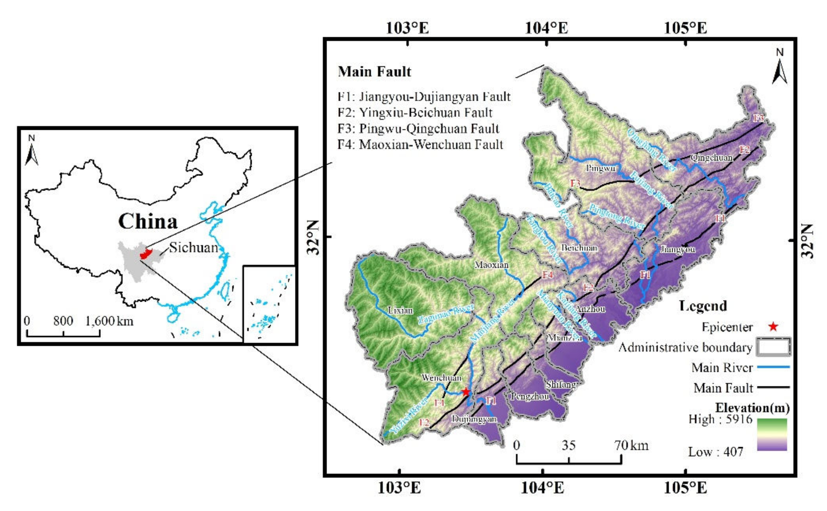
2.1. Study Area
2.2. Data
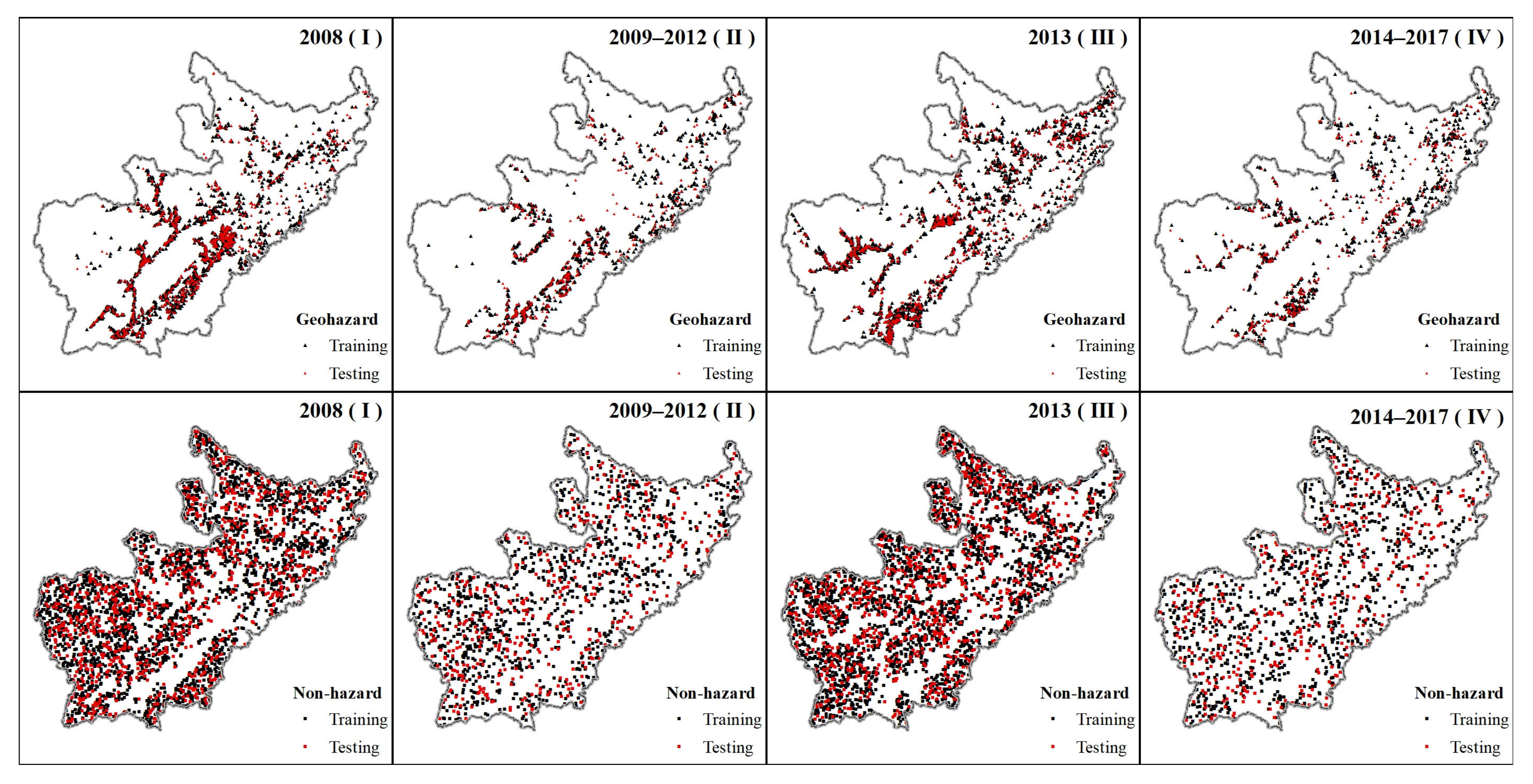
2.2.1. Inventory of Geohazards and Nonhazards
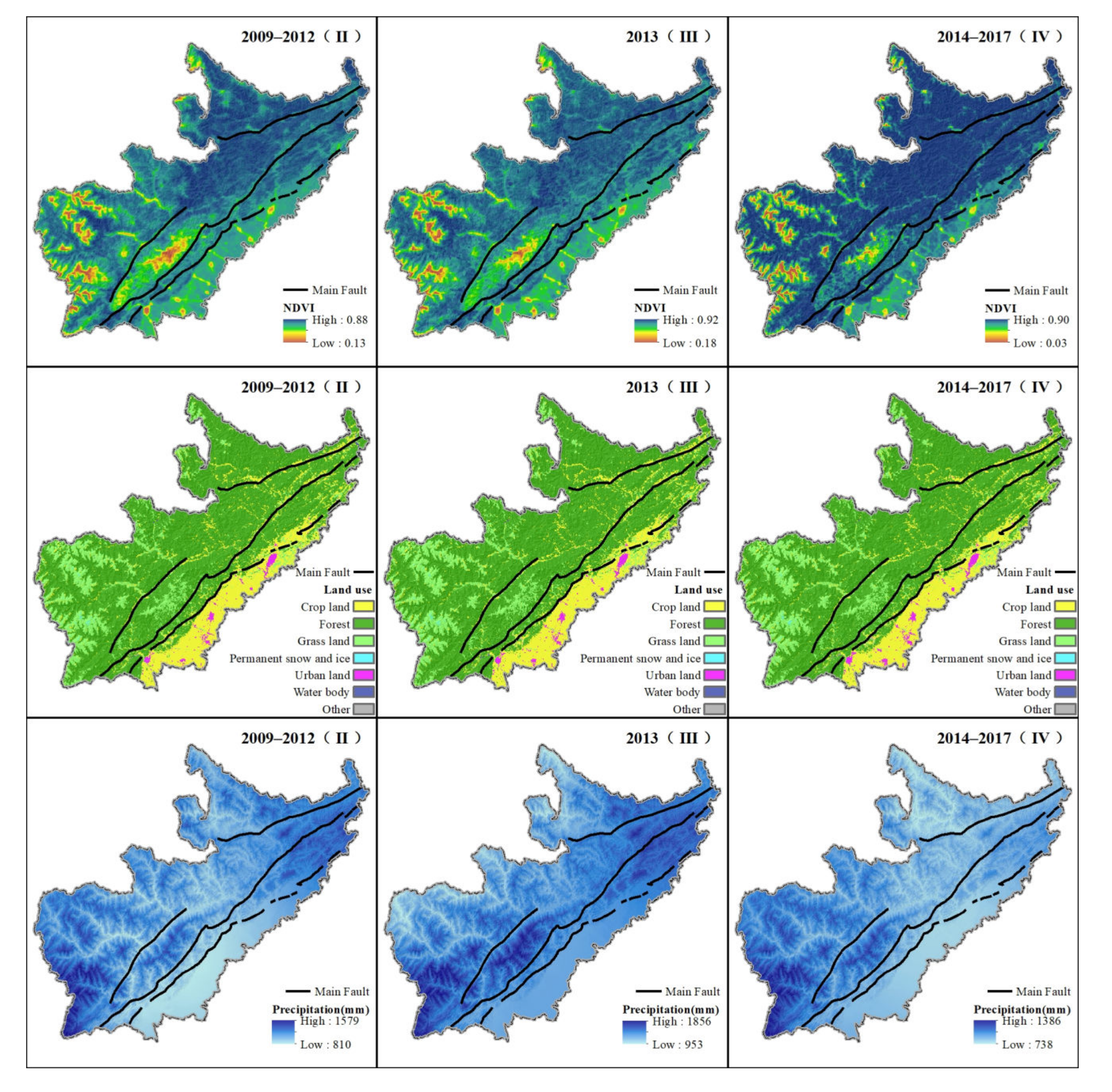
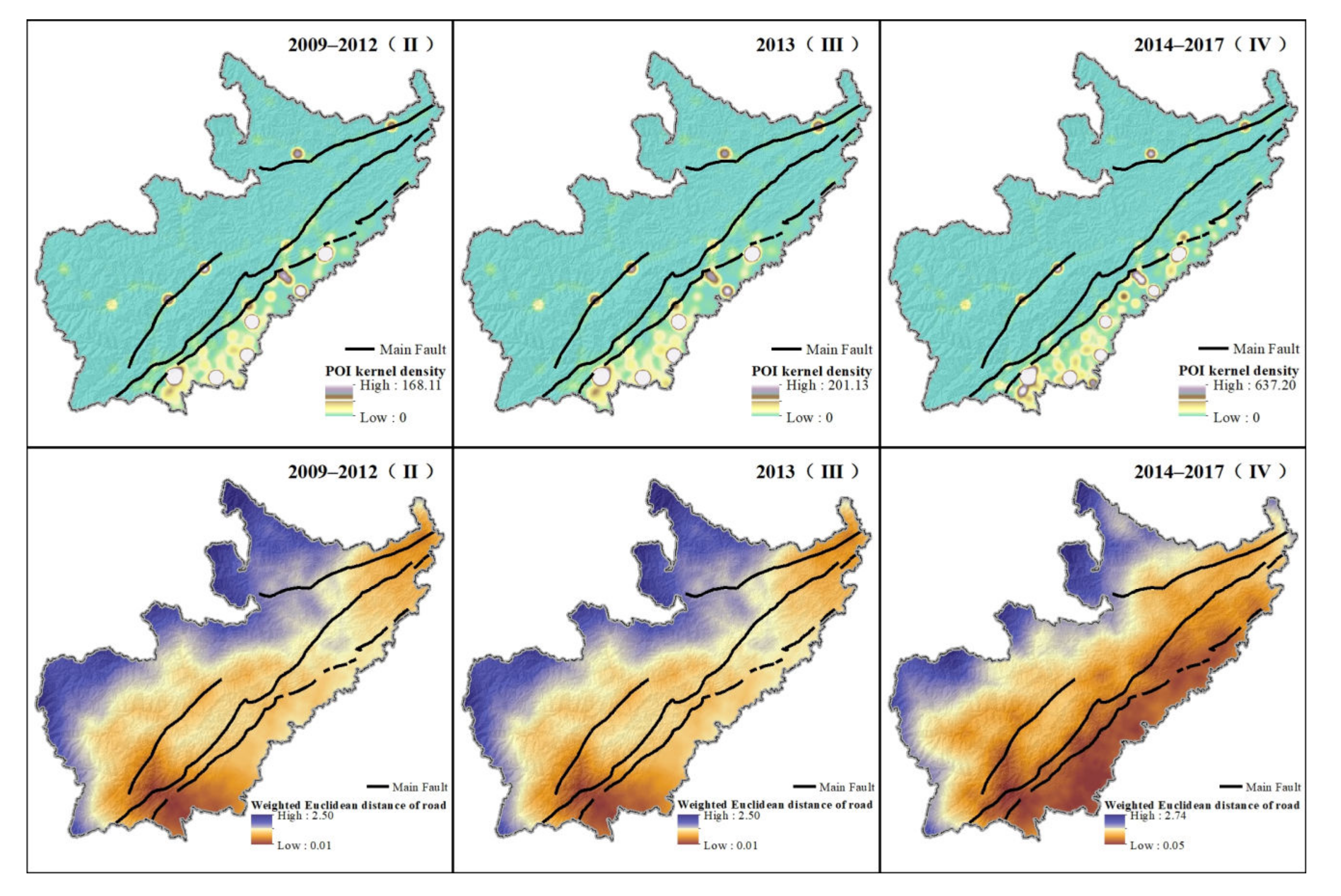
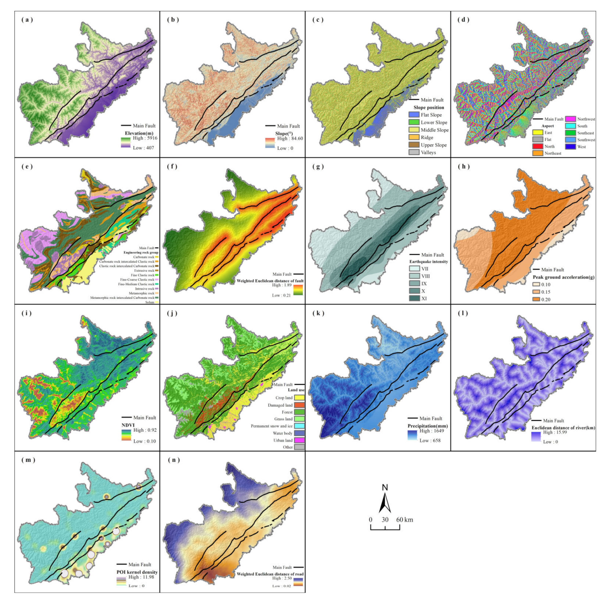
2.2.2. Impact Factor of Geohazards
2.3. Method
2.3.1. Random Forest (RF)
2.3.2. Partial Dependence Analysis
2.3.3. Evaluation of Model Accuracy
3. Results
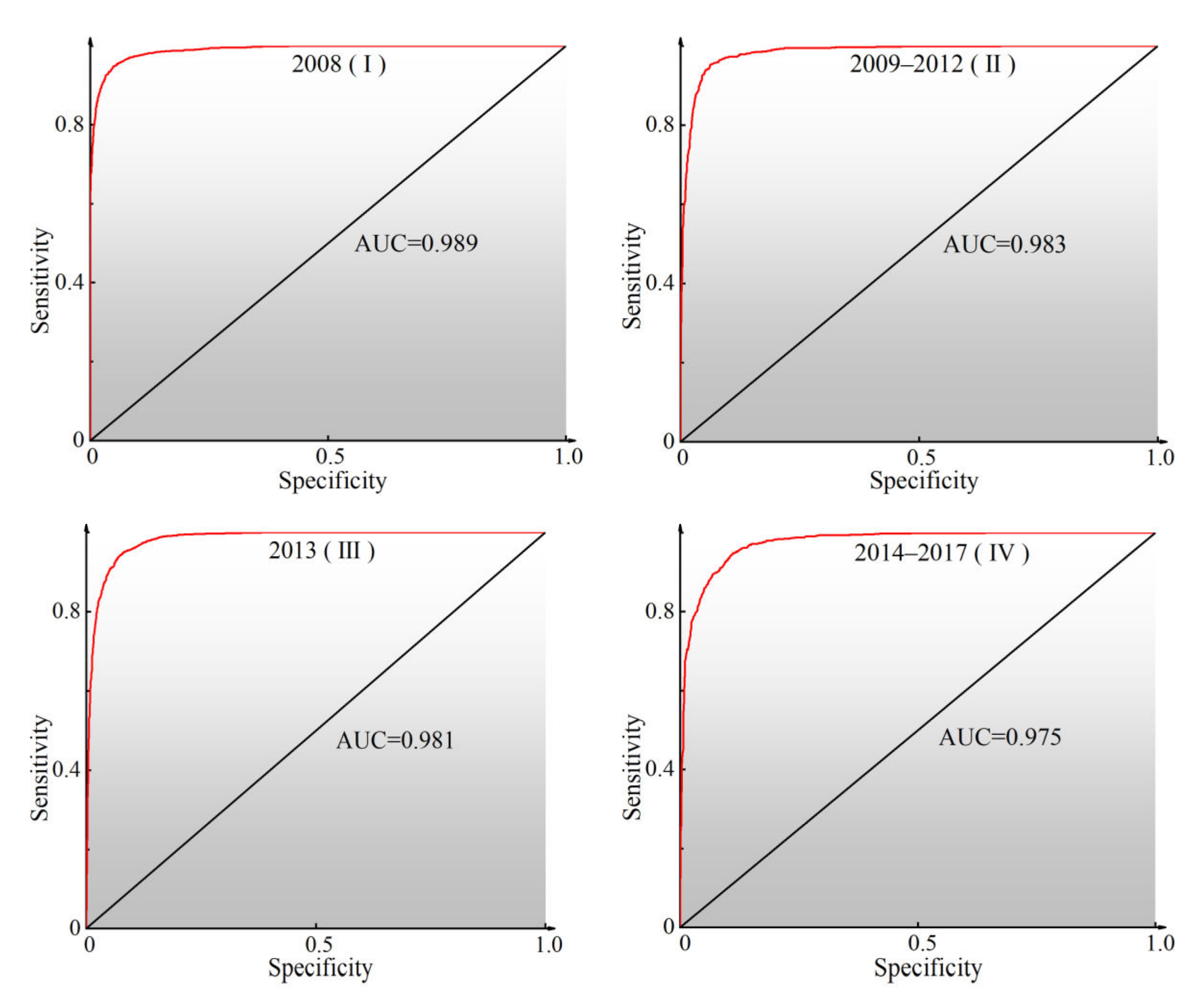
3.1. Model Accuracy Verification
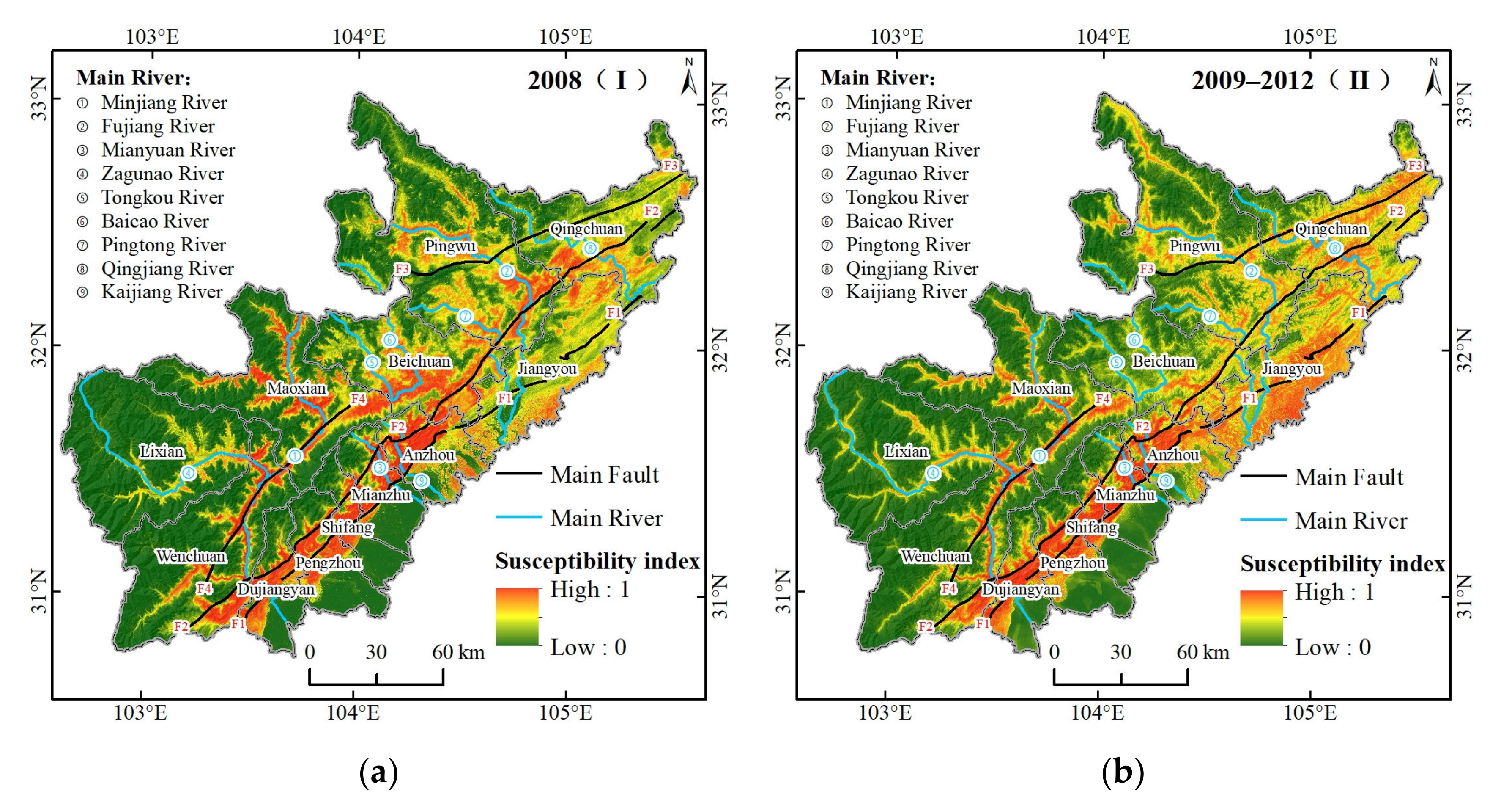
3.2. Spatial-Temporal Characteristics of Geohazard Susceptibility
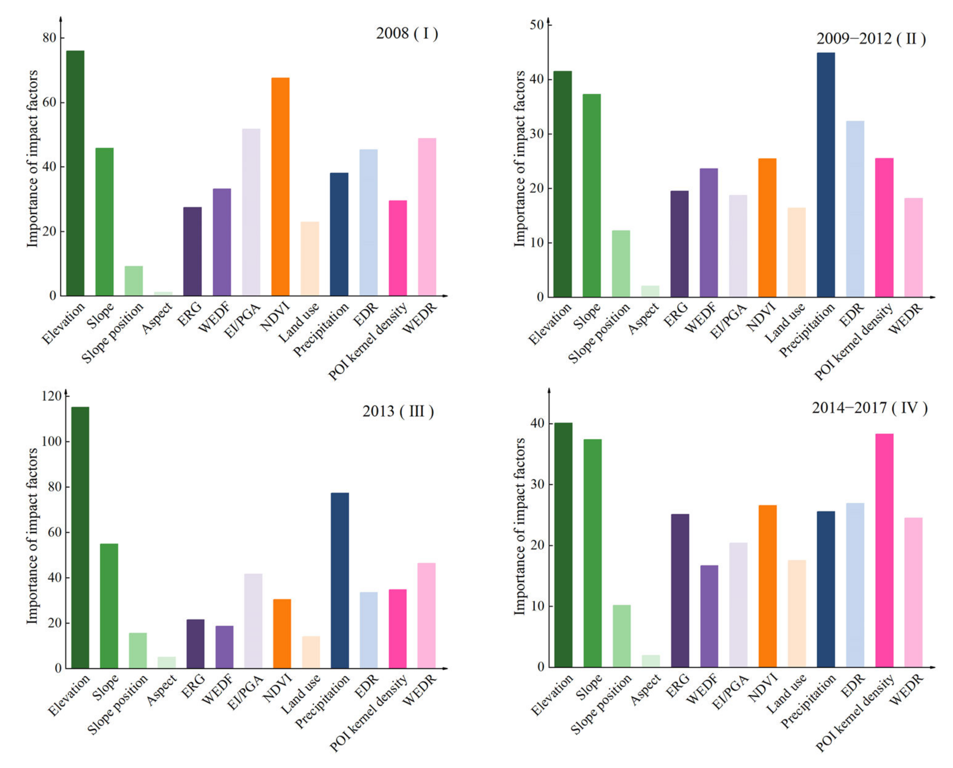
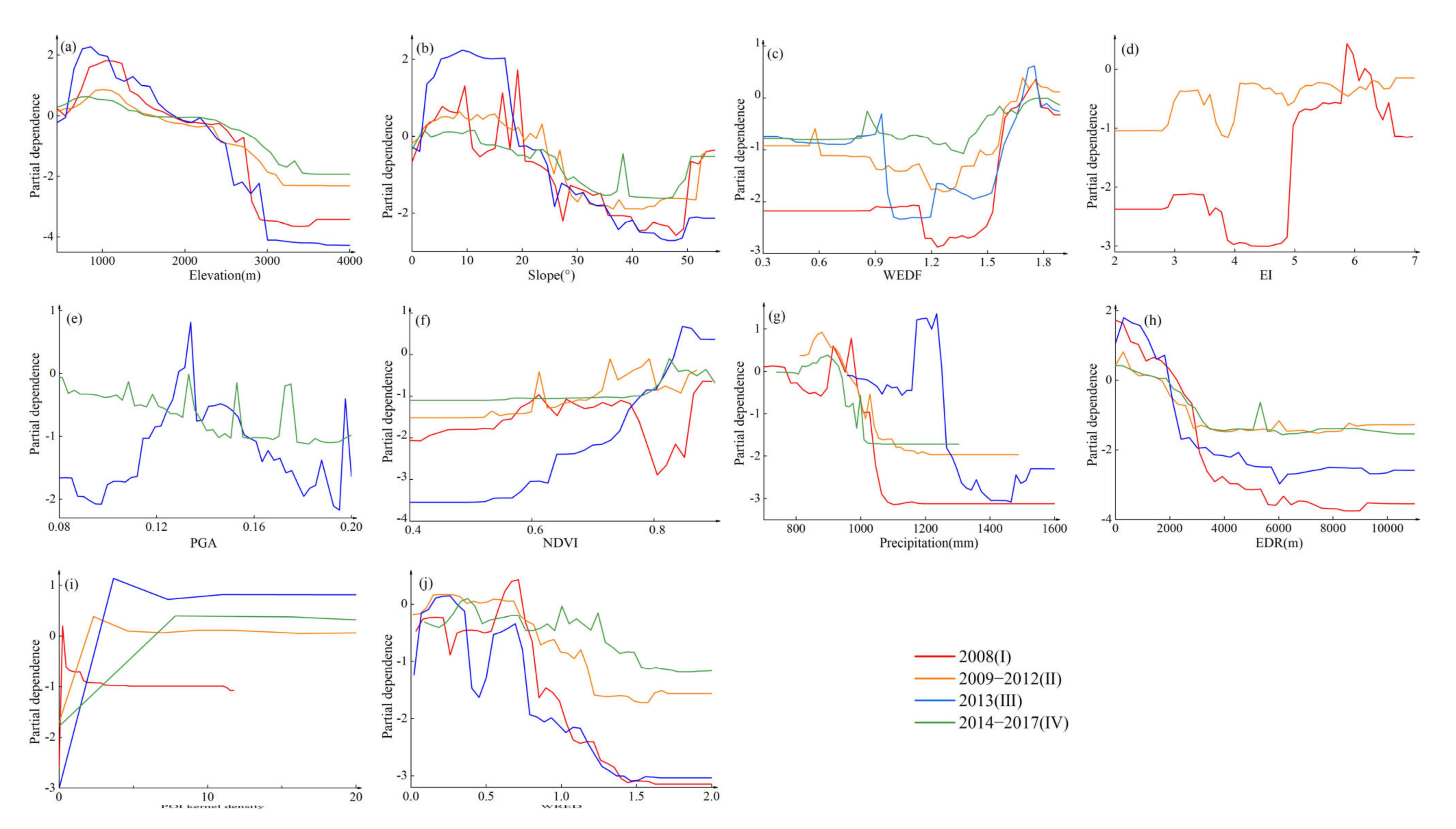
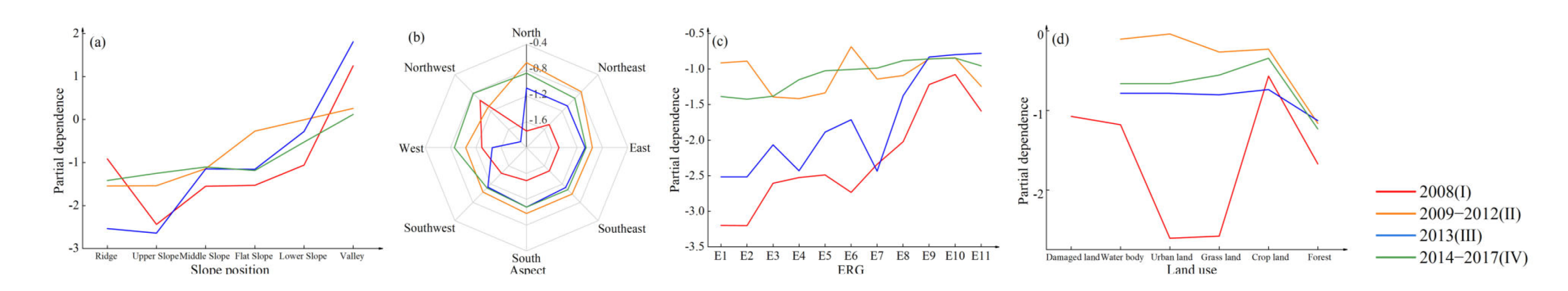
3.3. Factor Importance and Partial Dependence
4. Discussion
4.1. Verification of Geohazard Susceptibility
4.2. Analysis of Spatial-Temporal Characteristics of Geohazard Susceptibility
4.3. Cause Analysis of Spatial-Temporal Variation of Geohazard Susceptibility
4.3.1. Topographic Factors
4.3.2. Geological Factors
4.3.3. Land Cover Factors
4.3.4. Meteorological and Hydrological Factors
4.3.5. Anthropic Factors
4.4. Implications and Limitations
5. Conclusions
Author Contributions
Funding
Institutional Review Board Statement
Informed Consent Statement
Conflicts of Interest
Appendix A. Divided Data of Geohazard and Non-Hazard
Appendix B. Supplementary Data
References
- Zhou, N.Q.; Zhao, S. Urbanization process and induced environmental geological hazards in China. Nat. Hazards 2013, 67, 797–810. [Google Scholar] [CrossRef]
- Hou, J.; Lv, J.; Chen, X.; Yu, S. China’s regional social vulnerability to geological disasters: Evaluation and spatial characteristics analysis. Nat. Hazards 2015, 84, 97–111. [Google Scholar] [CrossRef]
- Ma, X.; Wu, Z.; Li, J. LiDAR Technology and its Application and Prospect in Geological Environment. J. Geomech. 2016, 22, 93–103. (In Chinese). Available online: http://www.cnki.com.cn/Article/CJFDTotal-DZLX201601010.htm (accessed on 23 December 2021).
- Zheng, X.; He, G.; Wang, S.; Wang, Y.; Wang, G.; Yang, Z.; Yu, J.; Wang, N. Comparison of Machine Learning Methods for Potential Active Landslide Hazards Identification with Multi-Source Data. ISPRS Int. J. Geo-Inf. 2021, 10, 253. [Google Scholar] [CrossRef]
- Wang, X.; Fan, X.; Yang, F.; Dong, X. Remote Sensing Interpretation Method of Geological Hazards in Lush Mountainous Area. Geomat. Inf. Sci. Wuhan Univ. 2020, 45, 1771–1781. (In Chinese). Available online: http://www.cnki.com.cn/Article/CJFDTotal-WHCH202011014.htm (accessed on 23 December 2021).
- Li, M.; Lv, J.; Chen, X.; Jiang, N. Provincial evaluation of vulnerability to geological disaster in China and its influencing factors: A three-stage DEA-based analysis. Nat. Hazards 2015, 79, 1649–1662. [Google Scholar] [CrossRef]
- Lee, D.-H.; Kim, Y.-T.; Lee, S.-R. Shallow Landslide Susceptibility Models Based on Artificial Neural Networks Considering the Factor Selection Method and Various Non-Linear Activation Functions. Remote Sens. 2020, 12, 1194. [Google Scholar] [CrossRef] [Green Version]
- Tsangaratos, P.; Ilia, I.; Hong, H.; Chen, W.; Xu, C. Applying Information Theory and GIS-based quantitative methods to produce landslide susceptibility maps in Nancheng County, China. Landslides 2016, 14, 1091–1111. [Google Scholar] [CrossRef]
- Liu, H.; Li, X.; Meng, T.; Liu, Y. Susceptibility mapping of damming landslide based on slope unit using frequency ratio model. Arab. J. Geosci. 2020, 13, 790–809. [Google Scholar] [CrossRef]
- Castellanos Abella, E.A.; Van Westen, C.J. Qualitative landslide susceptibility assessment by multicriteria analysis: A case study from San Antonio del Sur, Guantánamo, Cuba. Geomorphology 2008, 94, 453–466. [Google Scholar] [CrossRef] [Green Version]
- El Jazouli, A.; Barakat, A.; Khellouk, R. GIS-multicriteria evaluation using AHP for landslide susceptibility mapping in Oum Er Rbia high basin (Morocco). Geoenviron. Disasters 2019, 6, 3–15. [Google Scholar] [CrossRef]
- Ghiasi, V.; Ghasemi, S.A.R.; Yousefi, M. Landslide susceptibility mapping through continuous fuzzification and geometric average multi-criteria decision-making approaches. Nat. Hazards 2021, 107, 795–808. [Google Scholar] [CrossRef]
- Akgun, A.; Dag, S.; Bulut, F. Landslide susceptibility mapping for a landslide-prone area (Findikli, NE of Turkey) by likelihood-frequency ratio and weighted linear combination models. Environ. Geol. 2007, 54, 1127–1143. [Google Scholar] [CrossRef]
- Quan, H.-C.; Lee, B.-G. GIS-based landslide susceptibility mapping using analytic hierarchy process and artificial neural network in Jeju (Korea). KSCE J. Civ. Eng. 2012, 16, 1258–1266. [Google Scholar] [CrossRef]
- Felicísimo, Á.M.; Cuartero, A.; Remondo, J.; Quirós, E. Mapping landslide susceptibility with logistic regression, multiple adaptive regression splines, classification and regression trees, and maximum entropy methods: A comparative study. Landslides 2012, 10, 175–189. [Google Scholar] [CrossRef]
- Youssef, A.M.; Al-Kathery, M.; Pradhan, B. Landslide susceptibility mapping at Al-Hasher area, Jizan (Saudi Arabia) using GIS-based frequency ratio and index of entropy models. Geosci. J. 2014, 19, 113–134. [Google Scholar] [CrossRef]
- Pourghasemi, H.R.; Pradhan, B.; Gokceoglu, C.; Mohammadi, M.; Moradi, H.R. Application of weights-of-evidence and certainty factor models and their comparison in landslide susceptibility mapping at Haraz watershed, Iran. Arab. J. Geosci. 2012, 6, 2351–2365. [Google Scholar] [CrossRef]
- Erener, A.; Düzgün, H.S.B. Landslide susceptibility assessment: What are the effects of mapping unit and mapping method? Environ. Earth Sci. 2011, 66, 859–877. [Google Scholar] [CrossRef]
- Faraji Sabokbar, H.; Shadman Roodposhti, M.; Tazik, E. Landslide susceptibility mapping using geographically-weighted principal component analysis. Geomorphology 2014, 226, 15–24. [Google Scholar] [CrossRef]
- Pradhan, B. Landslide Susceptibility mapping of a catchment area using frequency ratio, fuzzy logic and multivariate logistic regression approaches. J. Indian Soc. Remote 2010, 38, 301–320. [Google Scholar] [CrossRef]
- Vakhshoori, V.; Pourghasemi, H.R.; Zare, M.; Blaschke, T. Landslide Susceptibility Mapping Using GIS-Based Data Mining Algorithms. Water 2019, 11, 2292. [Google Scholar] [CrossRef] [Green Version]
- Arabameri, A.; Pradhan, B.; Rezaei, K.; Sohrabi, M.; Kalantari, Z. GIS-based landslide susceptibility mapping using numerical risk factor bivariate model and its ensemble with linear multivariate regression and boosted regression tree algorithms. J. Mt. Sci. 2019, 16, 595–618. [Google Scholar] [CrossRef]
- Hong, H.; Pourghasemi, H.R.; Pourtaghi, Z.S. Landslide susceptibility assessment in Lianhua County (China): A comparison between a random forest data mining technique and bivariate and multivariate statistical models. Geomorphology 2016, 259, 105–118. [Google Scholar] [CrossRef]
- Pourghasemi, H.R.; Kerle, N. Random forests and evidential belief function-based landslide susceptibility assessment in Western Mazandaran Province, Iran. Environ. Earth Sci. 2016, 75, 185–202. [Google Scholar] [CrossRef]
- Fallah-Zazuli, M.; Vafaeinejad, A.; Alesheykh, A.A.; Modiri, M.; Aghamohammadi, H. Mapping landslide susceptibility in the Zagros Mountains, Iran: A comparative study of different data mining models. Earth Sci. Inform. 2019, 12, 615–628. [Google Scholar] [CrossRef]
- Park, S.; Hamm, S.-Y.; Kim, J. Performance Evaluation of the GIS-Based Data-Mining Techniques Decision Tree, Random Forest, and Rotation Forest for Landslide Susceptibility Modeling. Sustainability 2019, 11, 5659. [Google Scholar] [CrossRef] [Green Version]
- Saha, S.; Roy, J.; Pradhan, B.; Hembram, T.K. Hybrid ensemble machine learning approaches for landslide susceptibility mapping using different sampling ratios at East Sikkim Himalayan, India. Adv. Space Res. 2021, 68, 2819–2840. [Google Scholar] [CrossRef]
- Liu, Y.; Zhang, W.; Zhang, Z.; Xu, Q.; Li, W. Risk Factor Detection and Landslide Susceptibility Mapping Using Geo-Detector and Random Forest Models: The 2018 Hokkaido Eastern Iburi Earthquake. Remote Sens. 2021, 13, 1157. [Google Scholar] [CrossRef]
- Trigila, A.; Iadanza, C.; Esposito, C.; Scarascia-Mugnozza, G. Comparison of Logistic Regression and Random Forests techniques for shallow landslide susceptibility assessment in Giampilieri (NE Sicily, Italy). Geomorphology 2015, 249, 119–136. [Google Scholar] [CrossRef]
- Ada, M.; San, B.T. Comparison of machine-learning techniques for landslide susceptibility mapping using two-level random sampling (2LRS) in Alakir catchment area, Antalya, Turkey. Nat. Hazards 2017, 90, 237–263. [Google Scholar] [CrossRef]
- Pang, H.; Datta, D.; Zhao, H.Y. Pathway analysis using random forests with bivariate node-split for survival outcomes. Bioinformatics 2010, 26, 250–258. [Google Scholar] [CrossRef] [PubMed]
- Fan, R.L.; Zhang, L.M.; Wang, H.J.; Fan, X.M. Evolution of debris flow activities in Gaojiagou Ravine during 2008–2016 after the Wenchuan earthquake. Eng. Geol. 2018, 235, 1–10. [Google Scholar] [CrossRef]
- Yin, Y.; Wang, F.; Sun, P. Landslide hazards triggered by the 2008 Wenchuan earthquake, Sichuan, China. Landslides 2009, 6, 139–152. [Google Scholar] [CrossRef]
- Huang, Y.; Chen, W.; Liu, J. Secondary geological hazard analysis in Beichuan after the Wenchuan earthquake and recommendations for reconstruction. Environ. Earth Sci. 2010, 66, 1001–1009. [Google Scholar] [CrossRef]
- Guo, X.; Cui, P.; Marchi, L.; Ge, Y. Characteristics of rainfall responsible for debris flows in Wenchuan Earthquake area. Environ. Earth Sci. 2017, 76, 596–612. [Google Scholar] [CrossRef]
- Yang, J.; Chen, J.; Liu, H.; Zheng, J. Comparison of two large earthquakes in China: The 2008 Sichuan Wenchuan Earthquake and the 2013 Sichuan Lushan Earthquake. Nat. Hazards 2014, 73, 1127–1136. [Google Scholar] [CrossRef] [Green Version]
- Ge, Y.G.; Cui, P.; Zhang, J.Q.; Zeng, C.; Su, F.H. Catastrophic Debris Flows on July 10th 2013 along the Min River in Areas Seriously-hit by the Wenchuan Earthquake. J. Mt. Sci. 2015, 12, 186–206. [Google Scholar] [CrossRef]
- Shi, Z.; Wei, F.Q.; Chandrasekar, V. Radar-based quantitative precipitation estimation for the identification of debris flow occurrence over earthquake-affected regions in Sichuan, China. Nat. Hazard Earth Sys. 2018, 18, 765–780. [Google Scholar] [CrossRef] [Green Version]
- Wang, X.; Li, S.D.; Liu, H.H.; Liu, L.; Zeng, S.; Tang, Q.M. Landslide susceptibility assessment in Wenchuan County after the 5.12 magnitude earthquake. Bull. Eng. Geol. Environ. 2021, 80, 5369–5390. [Google Scholar] [CrossRef]
- Li, W.L.; Huang, R.Q.; Tang, C.; Xu, Q.; van Westen, C. Co-seismic landslide inventory and susceptibility mapping in the 2008 Wenchuan earthquake disaster area, China. J. Mt. Sci. 2013, 10, 339–354. [Google Scholar] [CrossRef]
- Ding, M.; Hu, K. Susceptibility mapping of landslides in Beichuan County using cluster and MLC methods. Nat. Hazards 2013, 70, 755–766. [Google Scholar] [CrossRef]
- Cui, P.; Xiang, L.Z.; Zou, Q. Risk assessment of highways affected by debris flows in Wenchuan earthquake area. J. Mt. Sci. 2013, 10, 173–189. [Google Scholar] [CrossRef]
- Deng, D.J.; Wang, C.L.; Peng, P.H. Basic Characteristics and Evolution of Geological Structures in the Eastern Margin of the Qinghai-Tibet Plateau. Earth Sci. Res. J. 2019, 23, 283–291. [Google Scholar] [CrossRef] [Green Version]
- Cui, S.H.; Pei, X.J.; Huang, R.Q. Effects of geological and tectonic characteristics on the earthquake-triggered Daguangbao landslide, China. Landslides 2018, 15, 649–667. [Google Scholar] [CrossRef]
- Wei, F.Q.; Su, P.C.; Jiang, Y.H. Distribution characteristics of landslides and debris flows in the Wenchuan earthquake region before and after the earthquake. Disaster Adv. 2012, 5, 285–294. [Google Scholar]
- Zhao, R.; Zhong, S.; He, A. Disaster Impact, National Aid, and Economic Growth: Evidence from the 2008 Wenchuan Earthquake. Sustainability 2018, 10, 4409–4431. [Google Scholar]
- Hadji, R.; Boumazbeur, A.E.; Limani, Y.; Baghem, M.; Chouabi, A.E.M.; Demdoum, A. Geologic, topographic and climatic controls in landslide hazard assessment using GIS modeling: A case study of Souk Ahras region, NE Algeria. Quat. Int. 2013, 302, 224–237. [Google Scholar] [CrossRef]
- Zhuang, J.Q.; Cui, P.; Hu, K.H.; Chen, X.Q.; Ge, Y.G. Characteristics of earthquake-triggered landslides and post-earthquake debris flows in Beichuan County. J. Mt. Sci. 2010, 7, 246–254. [Google Scholar] [CrossRef]
- Jiang, W.G.; Rao, P.Z.; Cao, R.; Tang, Z.H.; Chen, K. Comparative evaluation of geological disaster susceptibility using multi-regression methods and spatial accuracy validation. J. Geogr. Sci. 2017, 27, 439–462. [Google Scholar] [CrossRef] [Green Version]
- Wang, N.T.; Shi, T.T.; Peng, K.; Zhang, W.; Jin, X.W. Assessment of geohazard susceptibility based on RS and GIS analysis in Jianshi County of the Three Gorges Reservoir, China. Arab. J. Geosci. 2015, 8, 67–86. [Google Scholar] [CrossRef]
- Wang, M.; Liu, M.; Yang, S.; Shi, P. Incorporating Triggering and Environmental Factors in the Analysis of Earthquake-Induced Landslide Hazards. Int. J. Disaster Risk Sci. 2014, 5, 125–135. [Google Scholar] [CrossRef] [Green Version]
- Yang, Z.-H.; Lan, H.-X.; Gao, X.; Li, L.-P.; Meng, Y.-S.; Wu, Y.-M. Urgent landslide susceptibility assessment in the 2013 Lushan earthquake-impacted area, Sichuan Province, China. Nat. Hazards 2014, 75, 2467–2487. [Google Scholar] [CrossRef]
- Chen, X.-L.; Shan, X.-J.; Wang, M.-M.; Liu, C.-G.; Han, N.-N. Distribution Pattern of Coseismic Landslides Triggered by the 2017 Jiuzhaigou Ms 7.0 Earthquake of China: Control of Seismic Landslide Susceptibility. ISPRS Int. J. Geo-Inf. 2020, 9, 198. [Google Scholar] [CrossRef] [Green Version]
- Lyu, H.M.; Shen, S.L.; Yang, J.; Zhou, A.N. Risk Assessment of Earthquake-Triggered Geohazards Surrounding Wenchuan, China. Nat. Hazards Rev. 2020, 21, 05020007. [Google Scholar] [CrossRef]
- Pradhan, A.M.S.; Kim, Y.-T. Rainfall-Induced Shallow Landslide Susceptibility Mapping at Two Adjacent Catchments Using Advanced Machine Learning Algorithms. ISPRS Int. J. Geo-Inf. 2020, 9, 569. [Google Scholar] [CrossRef]
- Tian, Y.Y.; Xu, C.; Hong, H.Y.; Zhou, Q.; Wang, D. Mapping earthquake-triggered landslide susceptibility by use of artificial neural network (ANN) models: An example of the 2013 Minxian (China) Mw 5.9 event. Geomat. Nat. Hazards Risk 2019, 10, 1–25. [Google Scholar] [CrossRef] [Green Version]
- Dai, F.C.; Lee, C.F. Landslide characteristics and, slope instability modeling using GIS, Lantau Island, Hong Kong. Geomorphology 2002, 42, 213–228. [Google Scholar] [CrossRef]
- Chowdhuri, I.; Pal, S.C.; Arabameri, A.; Ngo, P.T.T.; Chakrabortty, R.; Malik, S.; Das, B.; Roy, P. Ensemble approach to develop landslide susceptibility map in landslide dominated Sikkim Himalayan region, India. Environ. Earth Sci. 2020, 79, 476–504. [Google Scholar] [CrossRef]
- He, Y.; Beighley, R.E. GIS-based regional landslide susceptibility mapping: A case study in southern California. Earth Surf. Proc. Land 2008, 33, 380–393. [Google Scholar] [CrossRef]
- Guo, D.P.; He, C.; Xu, C.; Hamada, M. Analysis of the relations between slope failure distribution and seismic ground motion during the 2008 Wenchuan earthquake. Soil Dyn. Earthq. Eng. 2015, 72, 99–107. [Google Scholar] [CrossRef]
- Fan, X.; Yunus, A.P.; Scaringi, G.; Catani, F.; Siva Subramanian, S.; Xu, Q.; Huang, R. Rapidly Evolving Controls of Landslides After a Strong Earthquake and Implications for Hazard Assessments. Geophys. Res. Lett. 2021, 48, 1–34. [Google Scholar] [CrossRef]
- Jiang, W.L.; Zhang, J.F.; Tian, T.; Wang, X. Crustal structure of Chuan-Dian region derived from gravity data and its tectonic implications. Phys. Earth Planet Inter. 2012, 212, 76–87. [Google Scholar] [CrossRef]
- Ding, Q.; Chen, W.; Hong, H. Application of frequency ratio, weights of evidence and evidential belief function models in landslide susceptibility mapping. Geocarto Int. 2016, 32, 619–639. [Google Scholar] [CrossRef]
- Chen, W.; Peng, J.; Hong, H.; Shahabi, H.; Pradhan, B.; Liu, J.; Zhu, A.X.; Pei, X.; Duan, Z. Landslide susceptibility modelling using GIS-based machine learning techniques for Chongren County, Jiangxi Province, China. Sci. Total Environ. 2018, 626, 1121–1135. [Google Scholar] [CrossRef]
- Guo, X.J.; Cui, P.; Li, Y.; Zhang, J.Q.; Ma, L.; Mahoney, W.B. Spatial features of debris flows and their rainfall thresholds in the Wenchuan earthquake-affected area. Landslides 2016, 13, 1215–1229. [Google Scholar] [CrossRef]
- Hong, H.; Chen, W.; Xu, C.; Youssef, A.M.; Pradhan, B.; Tien Bui, D. Rainfall-induced landslide susceptibility assessment at the Chongren area (China) using frequency ratio, certainty factor, and index of entropy. Geocarto Int. 2016, 32, 139–154. [Google Scholar] [CrossRef]
- Du, S.J.; Du, S.H.; Liu, B.; Zhang, X.Y.; Zheng, Z.J. Large-scale urban functional zone mapping by integrating remote sensing images and open social data. GISci. Remote Sens. 2020, 57, 411–430. [Google Scholar] [CrossRef]
- Wang, Y.; Sun, D.; Wen, H.; Zhang, H.; Zhang, F. Comparison of Random Forest Model and Frequency Ratio Model for Landslide Susceptibility Mapping (LSM) in Yunyang County (Chongqing, China). Int. J. Environ. Res. Public Health 2020, 17, 4206. [Google Scholar] [CrossRef]
- Zhang, Y.; Wu, W.; Qin, Y.; Lin, Z.; Zhang, G.; Chen, R.; Song, Y.; Lang, T.; Zhou, X.; Huangfu, W.; et al. Mapping Landslide Hazard Risk Using Random Forest Algorithm in Guixi, Jiangxi, China. ISPRS Int. J. Geo-Inf. 2020, 9, 695. [Google Scholar] [CrossRef]
- Bourenane, H.; Bouhadad, Y.; Guettouche, M.S.; Braham, M. GIS-based landslide susceptibility zonation using bivariate statistical and expert approaches in the city of Constantine (Northeast Algeria). Bull. Eng. Geol. Environ. 2014, 74, 337–355. [Google Scholar] [CrossRef]
- Breiman, L. Random forests. Mach. Learn. 2001, 45, 5–32. [Google Scholar] [CrossRef] [Green Version]
- Arabameri, A.; Pradhan, B.; Rezaei, K. Gully erosion zonation mapping using integrated geographically weighted regression with certainty factor and random forest models in GIS. J. Environ. Manag. 2019, 232, 928–942. [Google Scholar] [CrossRef] [PubMed]
- Knudby, A.; Brenning, A.; LeDrew, E. New approaches to modelling fish–habitat relationships. Ecol. Model. 2010, 221, 503–511. [Google Scholar] [CrossRef]
- Goetz, J.N.; Brenning, A.; Petschko, H.; Leopold, P. Evaluating machine learning and statistical prediction techniques for landslide susceptibility modeling. Comput. Geosci. 2015, 81, 1–11. [Google Scholar] [CrossRef]
- Hong, H.; Tsangaratos, P.; Ilia, I.; Liu, J.; Zhu, A.X.; Chen, W. Application of fuzzy weight of evidence and data mining techniques in construction of flood susceptibility map of Poyang County, China. Sci. Total Environ. 2018, 625, 575–588. [Google Scholar] [CrossRef]
- Arabameri, A.; Yamani, M.; Pradhan, B.; Melesse, A.; Shirani, K.; Tien Bui, D. Novel ensembles of COPRAS multi-criteria decision-making with logistic regression, boosted regression tree, and random forest for spatial prediction of gully erosion susceptibility. Sci. Total Environ. 2019, 688, 903–916. [Google Scholar] [CrossRef]
- Zhang, Q.W.; Gao, W.J.; Su, S.L.; Weng, M.; Cai, Z.L. Biophysical and socioeconomic determinants of tea expansion: Apportioning their relative importance for sustainable land use policy. Land Use Policy 2017, 68, 438–447. [Google Scholar] [CrossRef]
- Friedman, J.H. Greedy function approximation: A gradient boosting machine. Ann. Stat. 2001, 29, 1189–1232. [Google Scholar] [CrossRef]
- Nhu, V.H.; Mohammadi, A.; Shahabi, H.; Ahmad, B.B.; Al-Ansari, N.; Shirzadi, A.; Clague, J.J.; Jaafari, A.; Chen, W.; Nguyen, H. Landslide Susceptibility Mapping Using Machine Learning Algorithms and Remote Sensing Data in a Tropical Environment. Int. J. Environ. Res. Public Health 2020, 17, 4933. [Google Scholar] [CrossRef]
- Chen, W.; Xie, X.; Peng, J.; Shahabi, H.; Hong, H.; Bui, D.T.; Duan, Z.; Li, S.; Zhu, A.X. GIS-based landslide susceptibility evaluation using a novel hybrid integration approach of bivariate statistical based random forest method. Catena 2018, 164, 135–149. [Google Scholar] [CrossRef]
- Pontius, R.G.; Schneider, L.C. Land-cover change model validation by an ROC method for the Ipswich watershed, Massachusetts, USA. Agric. Ecosyst. Environ. 2001, 85, 239–248. [Google Scholar] [CrossRef]
- Chen, W.; Zhang, S.; Li, R.; Shahabi, H. Performance evaluation of the GIS-based data mining techniques of best-first decision tree, random forest, and naive Bayes tree for landslide susceptibility modeling. Sci. Total Environ. 2018, 644, 1006–1018. [Google Scholar] [CrossRef]
- Yu, X.Y.; Wang, Y.; Niu, R.Q.; Hu, Y.J. A Combination of Geographically Weighted Regression, Particle Swarm Optimization and Support Vector Machine for Landslide Susceptibility Mapping: A Case Study at Wanzhou in the Three Gorges Area, China. Int. J. Environ. Res. Public Health 2016, 13, 487. [Google Scholar] [CrossRef] [Green Version]
- Li, W.P.; Wen, D.G.; Zhou, A.G.; Sun, X.M.; Meng, H.; Shi, J.S.; Chen, Z.Y.; Zhang, L.Q.; Feng, X.M.; Liu, C.L.; et al. Assessment of Geological Security and Integrated Assessment Geo-environmental Suitability in Worst-hit Areas in Wenchuan Quake. Acta Geol. Sin.-Engl. Ed. 2009, 83, 816–825. [Google Scholar] [CrossRef]
- Cao, J.; Zhang, Z.; Wang, C.; Liu, J.; Zhang, L. Susceptibility assessment of landslides triggered by earthquakes in the Western Sichuan Plateau. Catena 2019, 175, 63–76. [Google Scholar] [CrossRef]
- Wang, Y.; Song, C.; Lin, Q.; Li, J. Occurrence probability assessment of earthquake-triggered landslides with Newmark displacement values and logistic regression: The Wenchuan earthquake, China. Geomorphology 2016, 258, 108–119. [Google Scholar] [CrossRef]
- Wang, J.; Zhu, S.; Luo, X.; Chen, G.; Xu, Z.; Liu, X.; Li, Y. Refined micro-scale geological disaster susceptibility evaluation based on UAV tilt photography data and weighted certainty factor method in Qingchuan County. Ecotoxicol. Environ. Saf. 2020, 189, 110005. [Google Scholar] [CrossRef]
- Comert, R. Investigation of the Effect of the Dataset Size and Type in the Earthquake-Triggered Landslides Mapping: A Case Study for the 2018 Hokkaido Iburu Landslides. Front. Earth Sci. 2021, 9, 23. [Google Scholar] [CrossRef]
- Chen, T.H.K.; Prishchepov, A.V.; Fensholt, R.; Sabel, C.E. Detecting and monitoring long-term landslides in urbanized areas with nighttime light data and multi-seasonal Landsat imagery across Taiwan from 1998 to 2017. Remote Sens. Environ. 2019, 225, 317–327. [Google Scholar] [CrossRef]
- Yang, Z.; Lan, H.; Zhang, Y.; Guo, C. Research Review on Long-term Activity of Post-earthquake Geohazard in Strong Seismic-disturbed Regions. J. Geomech. 2017, 23, 743–753. (In Chinese). Available online: http://www.cnki.com.cn/Article/CJFDTotal-DZLX201705036.htm (accessed on 23 December 2021).
- Liu, C.; Wen, M.; Liu, Y.; Liu, Q.; Gu, X. Regional Assessment on Geological Disasters in “5.12” Wenchuan Seismic Area, China. Hydrogeol. Eng. Geol. 2016, 43, 1–16. (In Chinese). Available online: http://www.cnki.com.cn/Article/CJFDTotal-SWDG201605001.htm (accessed on 23 December 2021).
- Luo, C.; Chen, T.; Fu, Q.; Li, S.; Wu, S. Temporal-spatial Distribution and Disaster-inducing Environment of Geo-hazards in Jiangyou City, Sichuan Province, China. Yangtze River 2019, 50, 95–100. (In Chinese). Available online: http://www.cnki.com.cn/Article/CJFDTotal-RIVE201912018.htm (accessed on 23 December 2021).
- Zhang, L.M.; Zhang, S.; Huang, R.Q. Multi-hazard scenarios and consequences in Beichuan, China: The first five years after the 2008 Wenchuan earthquake. Eng. Geol. 2014, 180, 4–20. [Google Scholar] [CrossRef]
- Long, Y.; Li, W.; Huang, R.; Xu, Q.; Yu, B.; Liu, G. Automatic Extraction and Evolution Trend Analysis of Landslides in Mianyuan River Basin in the 10 Years After Wenchuan Earthquake. Geomat. Inf. Sci. Wuhan Univ. 2020, 45, 1792–1800. (In Chinese). Available online: http://www.cnki.com.cn/Article/CJFDTotal-WHCH202011016.htm (accessed on 23 December 2021).
- Ju, N.; Hou, W.; Zhao, J.; Zhang, L. Geohazards of Jushui River in the Wenchuan Earthquake Area. Mt. Res. 2010, 28, 732–740. (In Chinese). Available online: http://www.cnki.com.cn/Article/CJFDTotal-SDYA201006016.htm (accessed on 23 December 2021).
- Huang, R.Q.; Li, W.L. Analysis of the geo-hazards triggered by the 12 May 2008 Wenchuan Earthquake, China. Bull. Eng. Geol. Environ. 2009, 68, 363–371. [Google Scholar] [CrossRef]
- Wu, C.H.; Cui, P.; Li, Y.S.; Ayala, I.A.; Huang, C.; Yi, S.J. Seismogenic fault and topography control on the spatial patterns of landslides triggered by the 2017 Jiuzhaigou earthquake. J. Mt. Sci. 2018, 15, 793–807. [Google Scholar] [CrossRef]
- Duan, L.; Zheng, W.; Li, M.; Deng, G.; Yang, G. Geologic Hazards on the Western Sichuan Plateau and Their Controls. Sediment. Geol. Tethyan Geol. 2005, 25, 95–98. (In Chinese). Available online: http://lib.cqvip.com/Qikan/Article/Detail?id=20928227 (accessed on 23 December 2021).
- Qi, S.; Xu, Q.; Liu, C.; Zhang, B.; Liang, N.; Tong, L. Slope Instabilities in the Severest Disaster Area of 5·12 Wenchuan Earthquake. J. Eng. Geol. 2009, 17, 39–49. (In Chinese). Available online: http://www.cnki.com.cn/Article/CJFDTotal-GCDZ200901006.htm (accessed on 23 December 2021).
- Xu, C.; Dai, F.; Yao, X.; Chen, J.; Tu, X.; Sun, Y.; Wang, Z. GIS-Based Landslide Susceptibility Assessment Using Analytical Hierarchy Process in Wenchuan Earthquake Region. Chin. J. Rock Mech. Eng. 2009, 28, 3978–3985. (In Chinese). Available online: http://www.cnki.com.cn/Article/CJFDTotal-YSLX2009S2104.htm (accessed on 23 December 2021).
- Ye, R.; Deng, Q.; Wang, H. Landsides Identification Based on Image Classification: A Case Study on Guizhoulaocheng landslide in the Three Gorges Reservoir Area. Chin. J. Eng. Geophys. 2007, 04, 574–577. (In Chinese). Available online: http://www.cnki.com.cn/Article/CJFDTotal-GCDQ200706015.htm (accessed on 23 December 2021).
- Han, J.; Wu, S.; He, S.; Sun, W.; Zhang, C.; Wang, T.; Yang, J.; Shi, J. Basal Characteristics and Formation Mechanisms of Geological Hazards Triggered by the May 12, 2008 Wenchuan Earthquake with a Moment Magnitude of 8.0. Earth Sci. Front. 2009, 16, 306–326. (In Chinese). Available online: http://www.cnki.com.cn/Article/CJFDTotal-DXQY200903034.htm (accessed on 23 December 2021).
- Xu, C.; Xu, X.; Wu, X.; Dai, F.; Yao, X.; Yao, Q. Detailed Catalog of Landslides Triggered by the 2008 Wenchuan earthquake and Statistical Analyses of Their Spatial Distribution. J. Eng. Geol. 2013, 21, 25–44. (In Chinese). Available online: http://www.cnki.com.cn/Article/CJFDTotal-GCDZ201301005.htm (accessed on 23 December 2021).
- Shi, J.; Shi, L.; Wu, S. Difficulties and Problematical Aspects of Landslide Risk Assessment: An Overview. Geol. Rev. 2007, 53, 797–806. (In Chinese). Available online: http://www.cnki.com.cn/Article/CJFDTotal-DZLP200706016.htm (accessed on 23 December 2021).
- Li, G.; Huang, R.; Ju, N.; Zhao, J. Study of Distribution and Development Laws of Secondary Disaster in Longmenshan Area After Earthquake. Yangtze River 2011, 42, 23–28. (In Chinese). Available online: http://www.cnki.com.cn/Article/CJFDTotal-RIVE201104009.htm (accessed on 23 December 2021).
- Zhang, C.; Zhao, Y.; Ouyang, Y.; Ni, Z.; Liu, H.; Li, T. Influence of Geological Environment on Vegetation Coverage in the Eastern Edge of Qinghai-Tibet Plateau: A Case Study of Mianning. Sediment. Geol. Tethyan Geol. 2021. (In Chinese) [Google Scholar] [CrossRef]
- Kritikos, T.; Davies, T. Assessment of rainfall-generated shallow landslide/debris-flow susceptibility and runout using a GIS-based approach: Application to western Southern Alps of New Zealand. Landslides 2014, 12, 1051–1075. [Google Scholar] [CrossRef]
- Chang, M.; Tang, C.; Zhang, D.-D.; Ma, G.-C. Debris flow susceptibility assessment using a probabilistic approach: A case study in the Longchi area, Sichuan province, China. J. Mt. Sci. 2014, 11, 1001–1014. [Google Scholar] [CrossRef]
- Wen, H. A susceptibility mapping model of earthquake-triggered slope geohazards based on geo-spatial data in mountainous regions. Georisk Assess. Manag. Risk Eng. Syst. Geohazards 2015, 9, 25–36. [Google Scholar] [CrossRef]
- Gorum, T.; Fan, X.M.; van Westen, C.J.; Huang, R.Q.; Xu, Q.; Tang, C.; Wang, G.H. Distribution pattern of earthquake-induced landslides triggered by the 12 May 2008 Wenchuan earthquake. Geomorphology 2011, 133, 152–167. [Google Scholar] [CrossRef]
- Zhang, Y.; Guo, C.; Yao, X.; Yang, Z.; Wu, R.; Du, G. Research on the Geohazard Effect of Active Fault on the Eastern Margin of the Tibetan Plateau. Acta Geosci. Sin. 2016, 37, 277–286. (In Chinese). Available online: http://www.cnki.com.cn/Article/CJFDTotal-DQXB201603004.htm (accessed on 23 December 2021).
- Liu, H. Hazard assessment on secondary mountain-hazards triggered by the Wenchuan earthquake. J. Appl. Remote Sens. 2009, 3, 031645. [Google Scholar] [CrossRef]
- Huang, R.Q.; Li, Y.S.; Li, W.L. Engineering geological evaluation of reconstruction sites following the Wenchuan earthquake. Bull. Eng. Geol. Environ. 2009, 68, 449–458. [Google Scholar] [CrossRef]
- Huang, R.Q.; Li, W.L. Development and distribution of geohazards triggered by the 5.12 Wenchuan Earthquake in China. Sci. China Ser. E 2009, 52, 810–819. [Google Scholar] [CrossRef]
- Jiang, Z.; Fan, X.; Siva Subramanian, S.; Yang, F.; Tang, R.; Xu, Q.; Huang, R. Probabilistic rainfall thresholds for debris flows occurred after the Wenchuan earthquake using a Bayesian technique. Eng. Geol. 2021, 280, 105965–105980. [Google Scholar] [CrossRef]
- Ni, Z.; Yang, Z.; Li, W.; Zhao, Y.; He, Z. Decreasing Trend of Geohazards Induced by the 2008 Wenchuan Earthquake Inferred from Time Series NDVI Data. Remote. Sens. 2019, 11, 2192. [Google Scholar] [CrossRef] [Green Version]
- Cui, P.; Lin, Y.M.; Chen, C. Destruction of vegetation due to geo-hazards and its environmental impacts in the Wenchuan earthquake areas. Ecol. Eng. 2012, 44, 61–69. [Google Scholar] [CrossRef]
- Shi, P.; Yang, W. Compound effects of earthquakes and extreme weathers on geo-hazards in mountains. Clim. Chang. Res. 2020, 16, 405–414. (In Chinese). Available online: http://www.cnki.com.cn/Article/CJFDTotal-QHBH202004002.htm (accessed on 23 December 2021).
- Wang, G.; Xia, J.; Sun, N.; Wang, J.; Pang, Q.; Liu, C. Study on Function of Soil and Water Conservation for Different Vegetation Types of Yellow River Irrigation Area in the Yellow River Delta. J. Soil Water Conserv. 2015, 29, 111–116. (In Chinese). Available online: http://www.cnki.com.cn/Article/CJFDTotal-TRQS201502021.htm (accessed on 23 December 2021).
- Zhao, D.; Zhang, M.; Yu, M.; Zeng, Y.; Wu, B. Monitoring Agriculture and Forestry Recovery After the Wenchuan Earthquake. J. Remote Sens. 2014, 18, 958–970. (In Chinese). Available online: http://www.cnki.com.cn/Article/CJFDTotal-YGXB201404016.htm (accessed on 23 December 2021).
- Ni, Z.; He, Z.; Zhao, Y.; Wang, L.; Gao, H.; Cai, K. Study on Damaged Land in Heavy Disaster Area of Wenchuan Earthquake. Res. Soil Water Conserv. 2011, 18, 198–200. (In Chinese). Available online: http://www.cnki.com.cn/Article/CJFDTotal-STBY201103043.htm (accessed on 23 December 2021).
- Luo, Y.; Li, S.; Wang, Z. Geohazards Development Characteristics and Influence Factors Analysis Induced by Nepal Earthquake. J. Geo. Hazards Environ. Preserv. 2017, 28, 33–40. (In Chinese). Available online: http://www.cnki.com.cn/Article/CJFDTotal-DZHB201703008.htm (accessed on 23 December 2021).
- Gao, Y.; Yin, Y.; Li, B.; Feng, Z.; Wang, W.; Zhang, N.; Xing, A. Characteristics and numerical runout modeling of the heavy rainfall-induced catastrophic landslide–debris flow at Sanxicun, Dujiangyan, China, following the Wenchuan Ms 8.0 earthquake. Landslides 2017, 14, 1361–1374. [Google Scholar] [CrossRef]
- Zezere, J.L.; Ferreira, A.D.; Rodrigues, M.L. The role of conditioning and triggering factors in the occurrence of landslides: A case study in the area north of Lisbon (Portugal). Geomorphology 1999, 30, 133–146. [Google Scholar] [CrossRef]
- Cui, P.; Chen, X.-Q.; Zhu, Y.-Y.; Su, F.-H.; Wei, F.-Q.; Han, Y.-S.; Liu, H.-J.; Zhuang, J.-Q. The Wenchuan Earthquake (12 May 2008), Sichuan Province, China, and resulting geohazards. Nat. Hazards 2009, 56, 19–36. [Google Scholar] [CrossRef]
- Fu, B.; Shi, P.; Guo, H.; Okuyama, S.; Ninomiya, Y.; Wright, S. Surface deformation related to the 2008 Wenchuan earthquake, and mountain building of the Longmen Shan, eastern Tibetan Plateau. J. Asian Earth Sci. 2011, 40, 805–824. [Google Scholar] [CrossRef]
- Chang, M.; Liu, Y.; Zhou, C.; Che, H. Hazard assessment of a catastrophic mine waste debris flow of Hou Gully, Shimian, China. Eng. Geol. 2020, 275, 105733–105779. [Google Scholar] [CrossRef]
- Chen, P.; Hu, L.; Li, Y.; Deng, O. Sensitivity Assessment and Spatial Distribution of Soil Erosion in Longmen Mountains Region. Bull. Soil Water Conserv. 2017, 37, 237–241. (In Chinese). Available online: http://www.cnki.com.cn/Article/CJFDTotal-STTB201703040.htm (accessed on 23 December 2021).
- Cui, P.; Zou, Q.; Xiang, L.Z.; Zeng, C. Risk assessment of simultaneous debris flows in mountain townships. Prog. Phys. Geogr. 2013, 37, 516–542. [Google Scholar] [CrossRef]
- Hu, C. Investigation and Prevention of Geological Hazards for High-steep Slope of the Wenchuan to Maerkang Expressway. Highway 2018, 63, 62–67. (In Chinese). Available online: http://www.cnki.com.cn/Article/CJFDTotal-GLGL201809011.htm (accessed on 23 December 2021).
- Li, H.; Ren, G.; Li, Y.; Fan, R.; Li, C. Study on Relationship between Distribution of Geological Disaster and Environmental Impacts along Mountain Road: Case of Wenchuan to Maoxian Highway. Yangtze River 2017, 48, 66–71. (In Chinese). Available online: http://www.cnki.com.cn/Article/CJFDTotal-RIVE201719013.htm (accessed on 23 December 2021).
- Cui, G.; Zuo, K.; Zhang, G. Research on Disaster Prevention Route Selection of Highway Reconstruction after Strong Shock in Mountainous Area with High Intensity Earthquake. Highway 2017, 62, 144–148. (In Chinese). Available online: http://www.cnki.com.cn/Article/CJFDTotal-GLGL201710031.htm (accessed on 23 December 2021).
- Zhou, H.-J.; Wang, X.; Yuan, Y. Risk assessment of disaster chain: Experience from Wenchuan earthquake-induced landslides in China. J. Mt. Sci. 2015, 12, 1169–1180. [Google Scholar] [CrossRef]
- Fan, X.M.; Scaringi, G.; Korup, O.; West, A.J.; van Westen, C.J.; Tanyas, H.; Hovius, N.; Hales, T.C.; Jibson, R.W.; Allstadt, K.E.; et al. Earthquake-Induced Chains of Geologic Hazards: Patterns, Mechanisms, and Impacts. Rev. Geophys. 2019, 57, 421–503. [Google Scholar] [CrossRef] [Green Version]
- Zhao, G.; Zhu, X.; Ma, B. Geological Background Analysis of the Collapse and Landslide Lagging Behind Rainfall in Hebei Province. Hydrogeol. Eng. Geol. 2015, 42, 151–155. (In Chinese). Available online: http://www.cnki.com.cn/Article/CJFDTotal-SWDG201502024.htm (accessed on 23 December 2021).
- Liu, Y.; Fang, Z.; Wen, M.; Qu, B. Analysis of Geo-hazards and Rainfall in Northeast of Sichuan Province, China. Hydrogeol. Eng. Geol. 2014, 41, 111–115. (In Chinese). Available online: https://doc.paperpass.com/journal/20140026swdzgcdz.html (accessed on 23 December 2021).


| Period | Year | Geohazard | Nonhazard | ||
|---|---|---|---|---|---|
| Training | Testing | Training | Testing | ||
| I | 2008 | 2213 | 949 | 2215 | 949 |
| II | 2009–2012 | 1004 | 430 | 1008 | 433 |
| III | 2013 | 2120 | 909 | 2120 | 909 |
| IV | 2014–2017 | 915 | 392 | 916 | 392 |
| Type | Data Name | Data Sources | Spatial Resolution |
|---|---|---|---|
| Topographic factor | Elevation | ASF Data Search (https://search.asf.alaska.edu/) (Accessed on 20 May 2021) | |
| Slope | ASF Data Search (https://search.asf.alaska.edu/) (Accessed on 20 May 2021) | ||
| Slope position | Geospatial Data Cloud (https://www.gscloud.cn/) (Accessed on 20 May 2021) | ||
| Aspect | ASF Data Search (https://search.asf.alaska.edu/) (Accessed on 20 May 2021) | ||
| Geological factor | Engineering rock group | China Geological Survey (https://www.cgs.gov.cn/) (Accessed on 22 May 2021) | 1:500,000 |
| Fault | China Geological Survey (https://www.cgs.gov.cn/) (Accessed on 22 May 2021) | 1:500,000 | |
| Wenchuan earthquake intensity | China Earthquake Administration (https://www.cea.gov.cn/) (Accessed on 23 May 2021) | Vector Data | |
| Peak ground acceleration | China Earthquake Administration (https://www.cea.gov.cn/) (Accessed on 23 May 2021) | Vector Data | |
| Land cover factor | NDVI | NASA (https://modis.gsfc.nasa.gov/) (Accessed on 24 May 2021) | |
| Land use | ESA (https://maps.elie.ucl.ac.be/CCI/viewer/) (Accessed on 25 May 2021); GLOBELAND30 (https://www.globallandcover.com/) (Accessed on 25 May 2021) | ||
| Meteorological and hydrological factor | Precipitation | Resource and Environment Science and Data Center (https://www.resdc.cn/) (Accessed on 25 May 2021) | |
| River network | NASA (https://www.nasa.gov/) (Accessed on 28 May 2021) | Vector Data | |
| Anthropic factor | POI | Gaode Open Platform (https://lbs.amap.com/) (Accessed on 1 Jul 2021) | Vector Data |
| Road | National Catalogue Service for Geographic Information (https://www.webmap.cn/) (Accessed on 3 Jul 2021); NAVIINFO (https://www.navinfo.com/) (Accessed on 5 Jul 2021) | Vector Data |
| Metric | Equation | Definition |
|---|---|---|
| ACC | The proportion of geohazards and nonhazards points which are correctly classified | |
| Precision | The fraction of relevant instances in the retrieved instances | |
| SST | The percentage of geohazards points that are correctly classified | |
| SPF | The percentage of nonhazards points that are correctly classified | |
| Recall | The proportion of positive samples predicted to be correct |
| Period | Year | Prediction | Reference | Summation | Kappa | |
|---|---|---|---|---|---|---|
| Geohazard | Non-Hazard | |||||
| I | 2008 | Geohazard | 3084 | 75 | Precision: 0.976 | 0.952 |
| Nonhazard | 78 | 3089 | Precision: 0.975 | |||
| Summation | Recall: 0.975 | Recall: 0.976 | Accuracy: 0.976 | |||
| II | 2009–2012 | Geohazard | 1402 | 51 | Precision: 0.965 | 0.942 |
| Nonhazard | 32 | 1390 | Precision: 0.977 | |||
| Summation | Recall: 0.978 | Recall: 0.965 | Accuracy: 0.971 | |||
| III | 2013 | Geohazard | 2954 | 62 | Precision: 0.979 | 0.955 |
| Nonhazard | 75 | 2967 | Precision: 0.975 | |||
| Summation | Recall: 0.975 | Recall: 0.980 | Accuracy: 0.977 | |||
| IV | 2014–2017 | Geohazard | 1276 | 54 | Precision: 0.959 | 0.935 |
| Nonhazard | 31 | 1254 | Precision: 0.976 | |||
| Summation | Recall: 0.976 | Recall: 0.959 | Accuracy: 0.968 | |||
| Period (Year) | I (2008) | II (2009–2012) | III (2013) | IV (2014–2017) |
|---|---|---|---|---|
| I (2008) | 1.000 | 0.833 | 0.824 | 0.798 |
| II (2009–2012) | 0.833 | 1.000 | 0.848 | 0.881 |
| III (2013) | 0.824 | 0.848 | 1.000 | 0.826 |
| IV (2014–2017) | 0.798 | 0.881 | 0.826 | 1.000 |
| Geohazard Probability | Susceptibility Level | Grid Number | Area Proportion (%) | Geohazard Number | Geohazard Proportion (%) | Density Proportion (Pcs/km2) |
|---|---|---|---|---|---|---|
| <0.55 | Very low | 1,733,079 | 42.37 | 13 | 0.14 | 0.001 |
| 0.55–1.90 | Low | 910,353 | 22.25 | 225 | 2.52 | 0.031 |
| 1.90–2.75 | Medium | 649,682 | 15.88 | 1172 | 13.12 | 0.223 |
| 2.75–3.30 | High | 464,832 | 11.36 | 2515 | 28.16 | 0.668 |
| >3.30 | Very high | 332,727 | 8.14 | 5007 | 56.06 | 1.858 |
Publisher’s Note: MDPI stays neutral with regard to jurisdictional claims in published maps and institutional affiliations. |
© 2022 by the authors. Licensee MDPI, Basel, Switzerland. This article is an open access article distributed under the terms and conditions of the Creative Commons Attribution (CC BY) license (https://creativecommons.org/licenses/by/4.0/).
Share and Cite
Li, S.; Ni, Z.; Zhao, Y.; Hu, W.; Long, Z.; Ma, H.; Zhou, G.; Luo, Y.; Geng, C. Susceptibility Analysis of Geohazards in the Longmen Mountain Region after the Wenchuan Earthquake. Int. J. Environ. Res. Public Health 2022, 19, 3229. https://doi.org/10.3390/ijerph19063229
Li S, Ni Z, Zhao Y, Hu W, Long Z, Ma H, Zhou G, Luo Y, Geng C. Susceptibility Analysis of Geohazards in the Longmen Mountain Region after the Wenchuan Earthquake. International Journal of Environmental Research and Public Health. 2022; 19(6):3229. https://doi.org/10.3390/ijerph19063229
Chicago/Turabian StyleLi, Shuai, Zhongyun Ni, Yinbing Zhao, Wei Hu, Zhenrui Long, Haiyu Ma, Guoli Zhou, Yuhao Luo, and Chuntao Geng. 2022. "Susceptibility Analysis of Geohazards in the Longmen Mountain Region after the Wenchuan Earthquake" International Journal of Environmental Research and Public Health 19, no. 6: 3229. https://doi.org/10.3390/ijerph19063229