Article

Field Measurements of Wind Characteristics Using LiDAR on a Wind Farm with Downwind Turbines Installed in a Complex Terrain Region

1
Renewable Energy Research Center, National Institute of Advanced Industrial Science and Technology (AIST), Koriyama, Fukushima 963-0298, Japan
2
Hitachi Ltd., Chiyoda-ku, Tokyo 100-8280, Japan
*
Author to whom correspondence should be addressed.
Energies 2020, 13(19), 5135; https://doi.org/10.3390/en13195135
Submission received: 27 August 2020 / Revised: 24 September 2020 / Accepted: 25 September 2020 / Published: 2 October 2020
(This article belongs to the Section A3: Wind, Wave and Tidal Energy)

Abstract

:
Downwind turbines have favorable characteristics such as effective energy capture in up-flow wind conditions over complex terrains. They also have reduced risk of severe accidents in the event of disruptions to electrical networks during strong storms due to the free-yaw effect of downwind turbines. These favorable characteristics have been confirmed by wind-towing tank experiments and computational fluid dynamics (CFD) simulations. However, these advantages have not been fully demonstrated in field experiments on actual wind farms. In this study—although the final objective was to demonstrate the potential advantages of downwind turbines through field experiments—field measurements were performed using a vertical-profiling light detection and ranging (LiDAR) system on a wind farm with downwind turbines installed in complex terrains. To deduce the horizontal wind speed, vertical-profiling LiDARs assume that the flow of air is uniform in space and time. However, in complex terrains and/or in wind farms where terrain and/or wind turbines cause flow distortion or disturbances in time and space, this assumption is not valid, resulting in erroneous wind speed estimates. The magnitude of this error was evaluated by comparing LiDAR measurements with those obtained using a cup anemometer mounted on a meteorological mast and detailed analysis of line-of-sight wind speeds. A factor that expresses the nonuniformity of wind speed in the horizontal measurement plane of vertical-profiling LiDAR is proposed to estimate the errors in wind speed. The possibility of measuring and evaluating various wind characteristics such as flow inclination angles, turbulence intensities, wind shear and wind veer, which are important for wind turbine design and for wind farm operation is demonstrated. However, additional evidence of actual field measurements on wind farms in areas with complex terrains is required in order to obtain more universal and objective evaluations.

1. Introduction

Downwind turbines have the advantages of being able to generate power efficiently—even under up-flow wind conditions in complex terrains. They are also at reduced risk of collapse due to the free-yaw effect—even when electrical network failures occur during storms. Downwind turbines are therefore expected to offer a high degree of safety and reliability, even under the severe wind conditions that are frequently observed in Japan [1,2]. While the advantages of downwind turbines have been demonstrated through towing-tank experiments and computational fluid dynamics (CFD) simulations [3], they have not been fully verified on actual wind farms. The ultimate goal of the present study was to demonstrate the characteristics of downwind turbines in complex terrains. To begin with, we therefore conducted field measurements on a wind farm with downwind turbines installed over complex terrains. Specifically, we used a vertical-profiling light detection and ranging (LiDAR) system to evaluate the wind conditions around the downwind turbines.
The vertical-profiling LiDAR uses a conical scanning pattern directed skyward to evaluate wind speed. The assumption with these systems is that there is spatial and temporal uniformity in the wind on the altitude measurement plane. However, since wind conditions are rarely uniform, vertical-profiling LiDAR is considered to be more prone to measurement errors in complex terrains. For example, a study conducted using a vertical-profiling LiDAR in complex terrains in Japan [4] found considerable systematic and random errors in wind speed measurements when compared to measurements performed using a cup anemometer installed on a meteorological mast. In complex European terrains, which is generally considered to be less complex than that in Japan, measurement results obtained using continuous wave and pulsed LiDAR systems have been compared to those obtained with a cup anemometer and ultrasonic anemometer installed on a meteorological mast [5]. The results of that study revealed a strong correlation between both the types of LiDAR and the cup and ultrasonic anemometer and low scatter in horizontal wind speed, despite a systematic error of approximately 6% (i.e., the LiDAR results underestimated wind speed).
Using CFD simulations and engineering models, attempts have been made to analyze [6,7] and correct [8,9] errors caused by the surrounding topography in vertical-profiling LiDAR measurements. Vogstad et al. [8] reported that by introducing a correction based on appropriate CFD simulations, the uncertainty associated with LiDAR measurements performed in areas with complex terrains could be reduced to about 2.5%, which is comparable to measurements obtained using a cup anemometer.
In a comprehensive technical review on remote sensing technology, Pena Diaz et al. [10] concluded that, in the near future, LiDARs could replace meteorological masts, even in areas with complex terrains, if pre-measurement simulations are conducted to determine the optimal placement of the LiDAR followed by simulation-based corrections after the LiDAR measurements are obtained. A relatively long-term study (approximately one year) conducted by Goit et al. [11] showed good agreement in average wind speed and turbulence intensity between LiDAR and ultrasonic anemometer measurements, suggesting that LiDARs could replace meteorological masts to assess wind resources, annual energy production and loads.
It is conceivable that the errors associated with LiDAR measurements conducted in complex terrains can be decreased by reducing the cone angle of the conical laser beams directed, as this would reduce the area (assumed to be uniform) of the altitude measurement plane. Indeed, there are currently vertical-profiling LiDARs with such functionality (complex terrain mode). However, it has been confirmed, both theoretically [10] and experimentally [5], that the error in horizontal wind speed measurements obtained by LiDARs is independent of the cone angle.
Attempts have been made to measure and evaluate complex flow phenomena by wind turbine wakes or by complex terrains using scanning LiDARs [12,13,14]. A wake of a continuously yawing wind turbine in a large wind farm was detected by a single scanning LiDAR with plan position indicator (PPI) scans in flat terrains [12] and even in moderately complex coastal terrains [13]. In the famous Perdigão experiment, three sets of scanning lidar with different scan strategies such as arc [15], range height indicator (RHI) and velocity azimuth display (VAD) were operated to scan the wake of the wind turbine in highly complex terrains [14]. Vertical and horizontal profiles of a wake were derived by each scan strategy in that study, however integration data from independently operated three systems indicated some differences in wake center position and it is concluded that to identify common methods for further wake metrics such as wake width and wind speed deficit is the next steps.
Honrubia et al. [16] used a LiDAR to measure vertical changes in wind speed (wind shear) in relatively complex terrains in Europe and advocated the usefulness of LiDAR for inflow wind-shear measurements when evaluating wind turbine performance. However, as noted above, although there is a possibility that a vertical-profiling LiDAR can be moderately useful in mild complex terrains, few studies have been conducted in highly complicated terrains, such as that typically found in Japan. It is therefore not clear how reliable and accurate LiDARs are and for what purposes they can be used, in wind farms over highly complex terrains.
In this study, we therefore evaluated the accuracy and reliability of LiDAR wind measurements conducted in complex terrains, taking turbine wakes into account. In addition, we performed detailed analyses of the raw data obtained for line-of-sight (LOS) wind speeds. We also analyzed the wind characteristics of complex terrain sites, such as the flow inclination and turbulence intensity in different wind directions and investigated the relationship between the wind characteristics and topography in complex terrains with the future aim of evaluating of downwind turbine characteristics in such environments.

2. Test Site and Measurement Setup

In this study, we performed measurements on a wind farm in Japan. The wind farm employed Hitachi HTW 2.0-80 downwind turbines that had a hub height of 78 m and turbine diameters of 80 m. We installed a vertical-profiling LiDAR (DIABREZZA_W, Mitsubishi Electric Corporation) system between two wind turbines on the wind farm (a location hereinafter referred to as the “position between turbines”). The main LiDAR specifications used in this study are shown in Table 1. As shown in Figure 1, laser beams were directed skyward in five LOS directions ranging from LOS0 (vertical) to LOS4, at approximately at 0.4 s intervals. Using this system, we simultaneously measured the wind speed at 20 different altitudes ranging from 50 m to 126 m above ground level (AGL) at 4-m intervals. The half opening angle of the scanning cone is 30° (Figure 1a). A method to retrieve horizontal and vertical wind speeds from LOS data is generally used one for DBS (Doppler beam swinging) scan mode of LiDAR measurements [17]. In calibration tests conducted at well-known European test sites, such as ECN (the Energy Research Center in The Netherlands) and at DTU (the Technical University of Denmark), the wind speed and direction measurements obtained using the DIABREZZA_W have been demonstrated to be in good agreement with the results obtained using cup anemometers and wind vanes installed on meteorological masts [18].
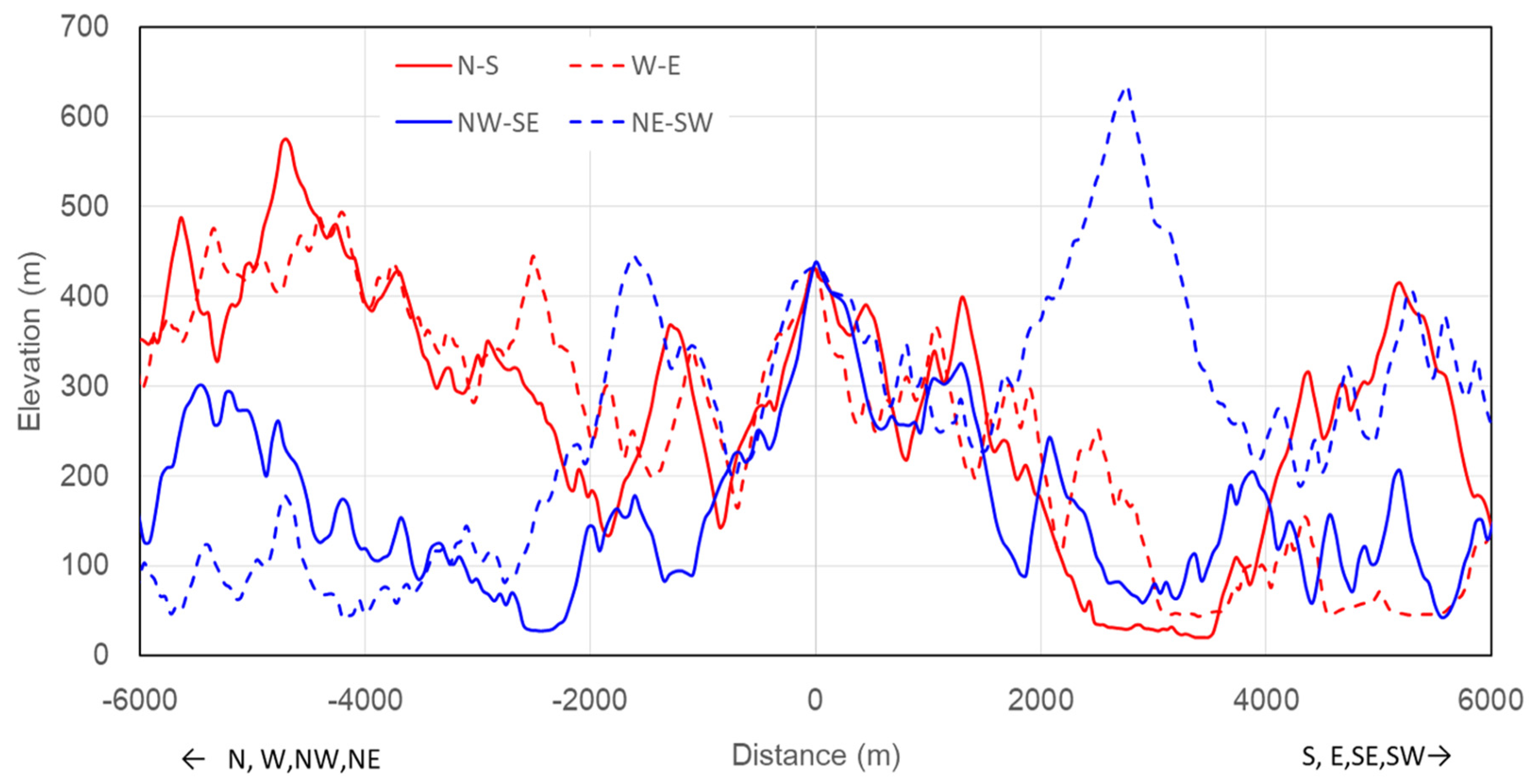
Figure 2 shows the locations of the LiDAR and two turbines and Figure 3 shows topographic profiles of the terrain in the north–south, west–east, northeast–southwest and northwest–southeast directions. The profiles show that the site is a highly complex terrain with a horizontal length of approximately 1000 m and an elevation difference of more than 300 m. The elevation of the measurement location (position between turbines) was 488 m above mean sea level (AMSL). The measurement period spanned approximately three months, from October 1 to December 26, 2017, excluding the period from November 7 to 12 when measurements were not taken due to system maintenance.
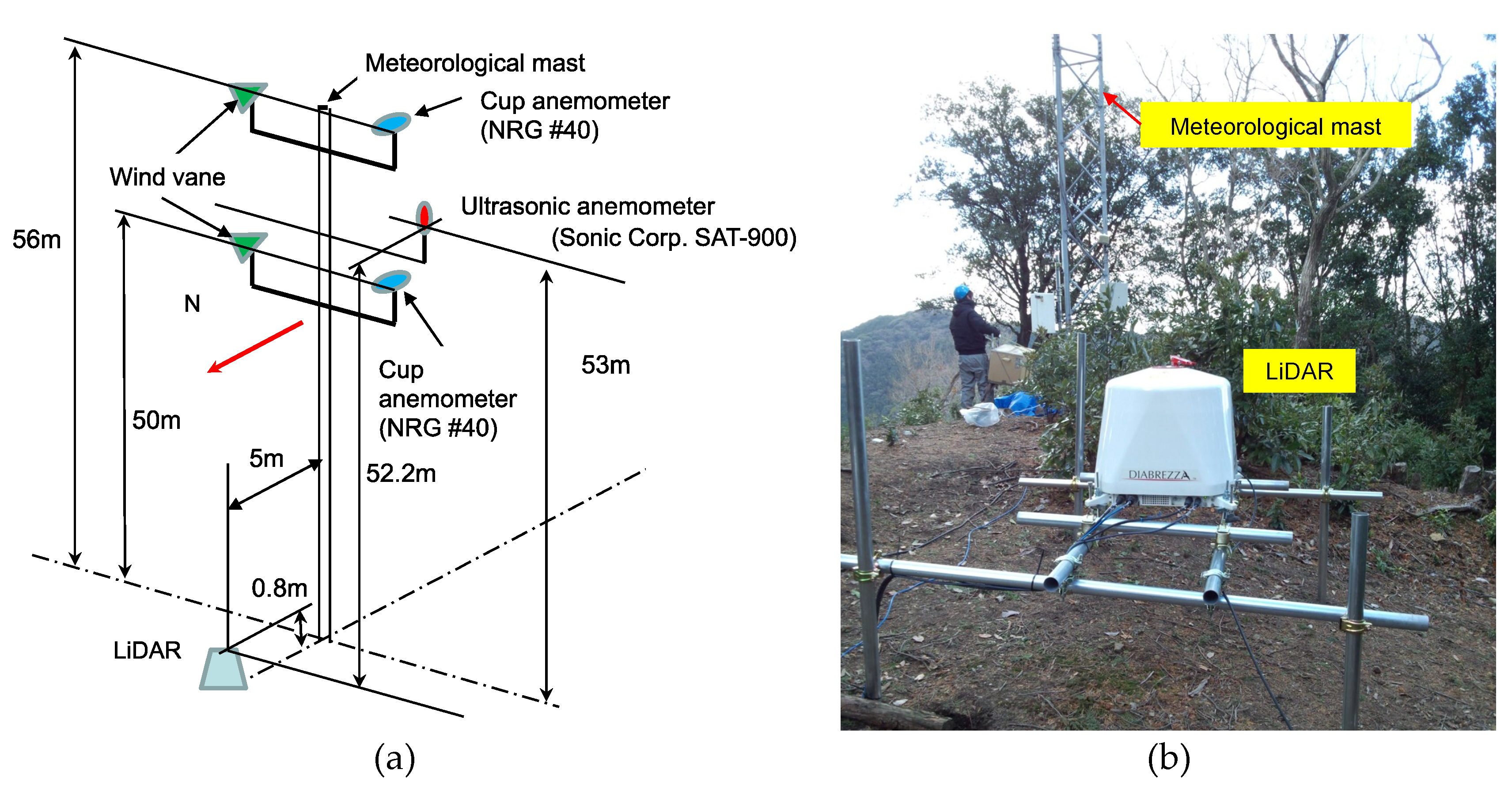
The LiDAR was then moved to a location where a meteorological mast was installed near the wind farm (hereinafter referred to as the “mast position”), to further evaluate the reliability of the vertical-profiling LiDAR measurements obtained in complex terrains. Figure 4 shows the schematic configuration of the sensors installed on the meteorological mast and a photo of the installed LiDAR, which was positioned 5 m north of the meteorological mast. In addition to cup anemometers and wind vanes, an ultrasonic anemometer/thermometer (SAT-900, sonic Corporation) was installed at a height of 53 m AGL. The topographic profiles in the north–south, west–east, northeast–southwest, and northwest–southeast cardinal directions in Figure 5 show that the mast position, like the position between turbines, was in a highly complex terrain with a horizontal length of about 1000 m and a difference in elevation of approximately 300 m. The elevation of the measurement location (mast position) was 431 m AMSL. The measurement period covered roughly one month, from 1–31 January 2018, excluding the period from January 19–26, when measurements were not taken due to maintenance.
Although the two LiDAR measurement locations differed with respect to topographical conditions, the horizontal distance between the locations was only about 1430 m and their topographic complexity and vegetation were similar.

3. Results and Discussion

3.1. Comparison with Meteorological Mast Measurements

A measurement method simultaneously utilizing a meteorological mast that is lower than the measurement height was used in Japan as a means of improving the accuracy and reliability of LiDAR measurement in complex terrains [4]. This correction method was shown to provide the same degree of data consistency as when measurements are performed on flat terrains. However, since this method could not be used at the present site, the reliability of the vertical-profiling LiDAR measurements in complex terrains was evaluated by simultaneous measurements using a meteorological mast installed at a location close to the wind farm, as described above.
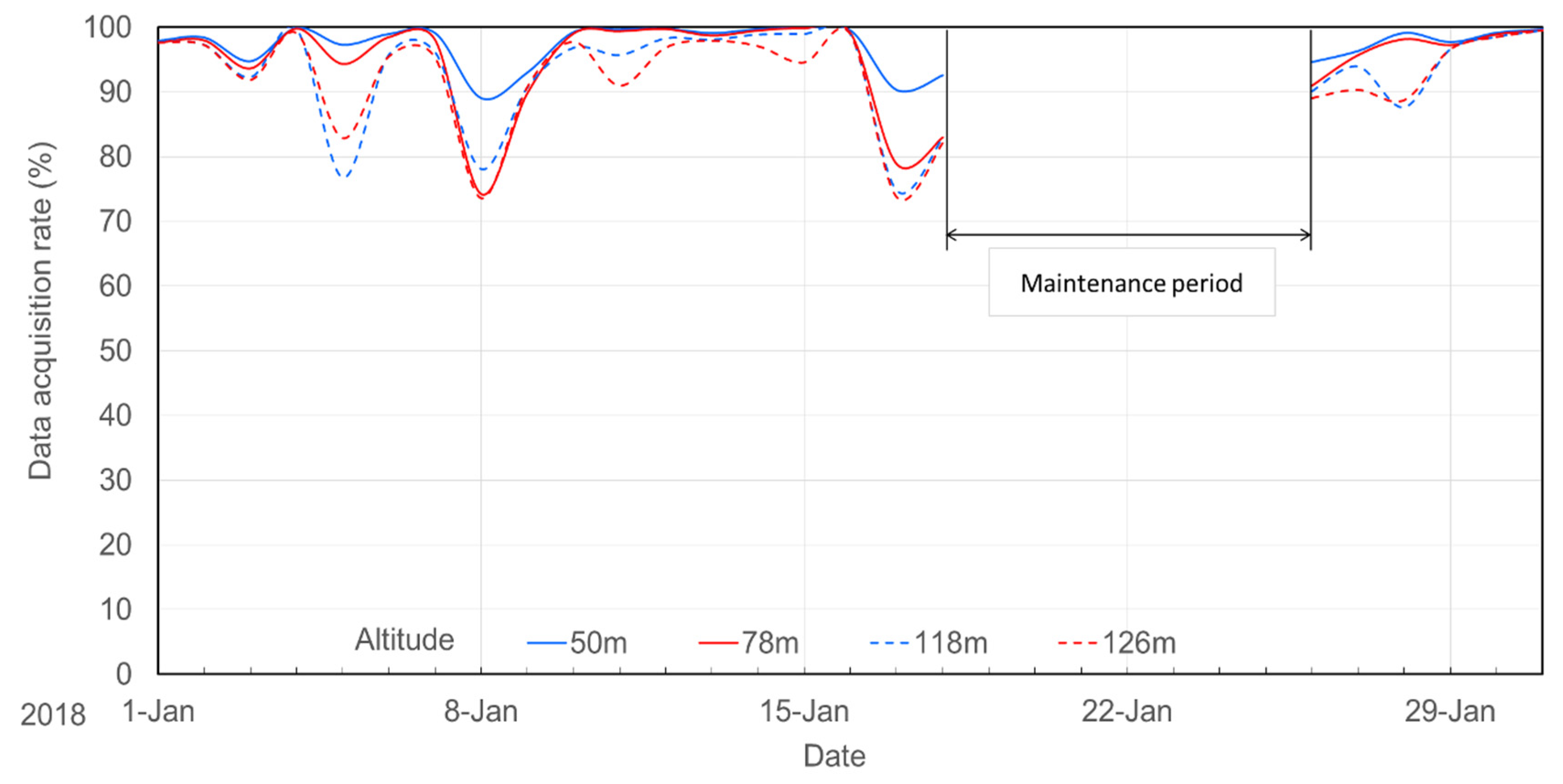
Figure 6 shows the data-acquisition rate of the LiDAR over time at the mast position, for representative heights of 50 m (minimum measurement height), 78 m (turbine hub height), 118 m (maximum turbine rotor height) and 126 m (maximum measurement height). The data with a signal-to-noise ratio (SNR) of 7 dB or more is treated as valid data, while the low SNR data were omitted in the LiDAR used in this study. Although the data-acquisition rate over the entire measurement period was at least 90% at 50 m AGL, there were three time periods where the data-acquisition rate fell below 80%, at the higher heights of 118 m and 126 m AGL. This decrease may have been attributed to greater concentrations of water vapor near the ground surface due to fog or the high elevation of the measurement location, which may have interfered with laser transmission. In this study, we used 10-min datasets with minimum data-acquisition rates of 80% and excluded all of the datasets with data-acquisition rates that were too low for statistical reliability.
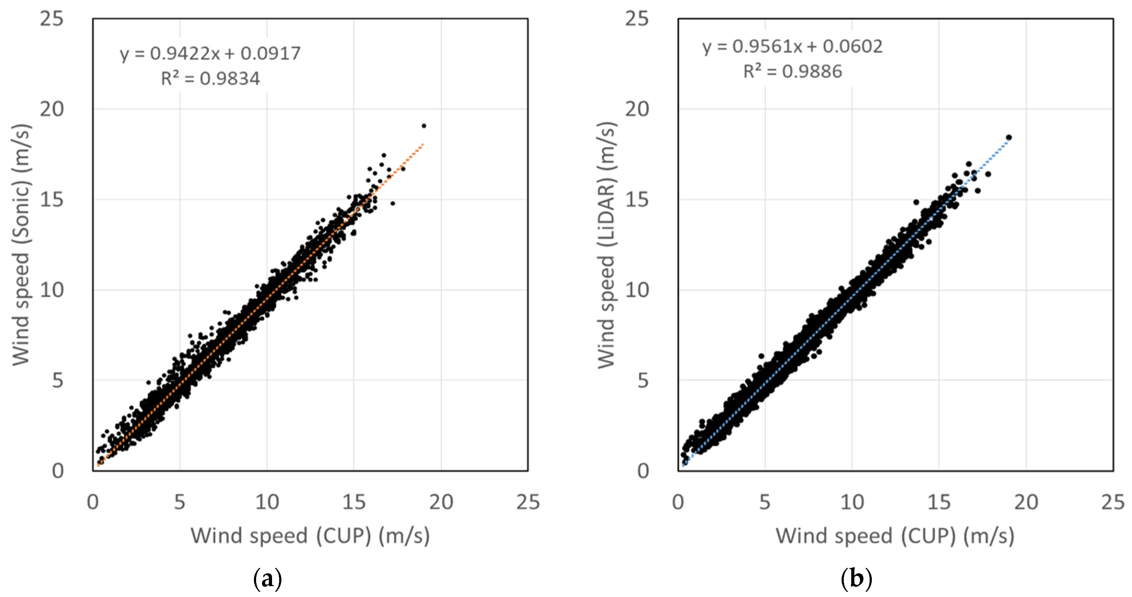
Figure 7 shows a comparison of horizontal wind speed measurements obtained with the cup anemometer, the LiDAR and the ultrasonic anemometer. Despite the high complexity of the terrain, the correlation between the wind speed measured by the LiDAR and the cup anemometer is relatively good, with a coefficient of determination R2 of 0.989, which was comparable to or better than, the correlation obtained between the ultrasonic and cup anemometers, both of which provide point measurements. However, these differences may be due to differences in the LiDAR equipment used, terrain conditions, and/or surrounding conditions, compared to previous measurements [4]. The LiDAR slightly underestimates the wind speed compared with the cup anemometer, with a gradient of 0.956 and it is difficult to specify the reason for underestimation by means of data acquired in this study, while it is predicted that the horizontal separation distance between the LiDAR and the meteorological mast (5 m) and the difference between volume average measurement by the LiDAR and point measurement by the cup anemometer affect the difference.
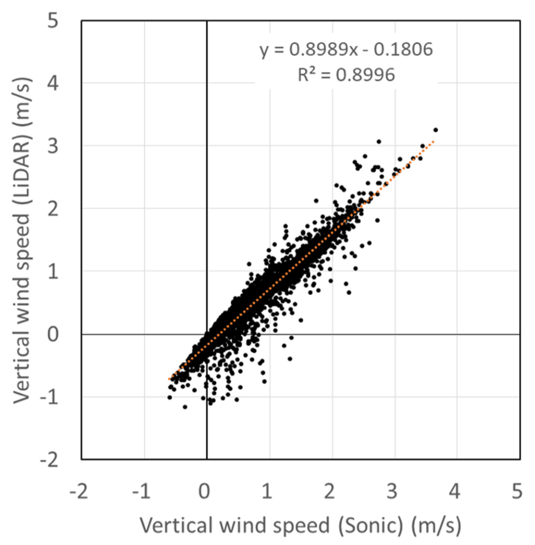
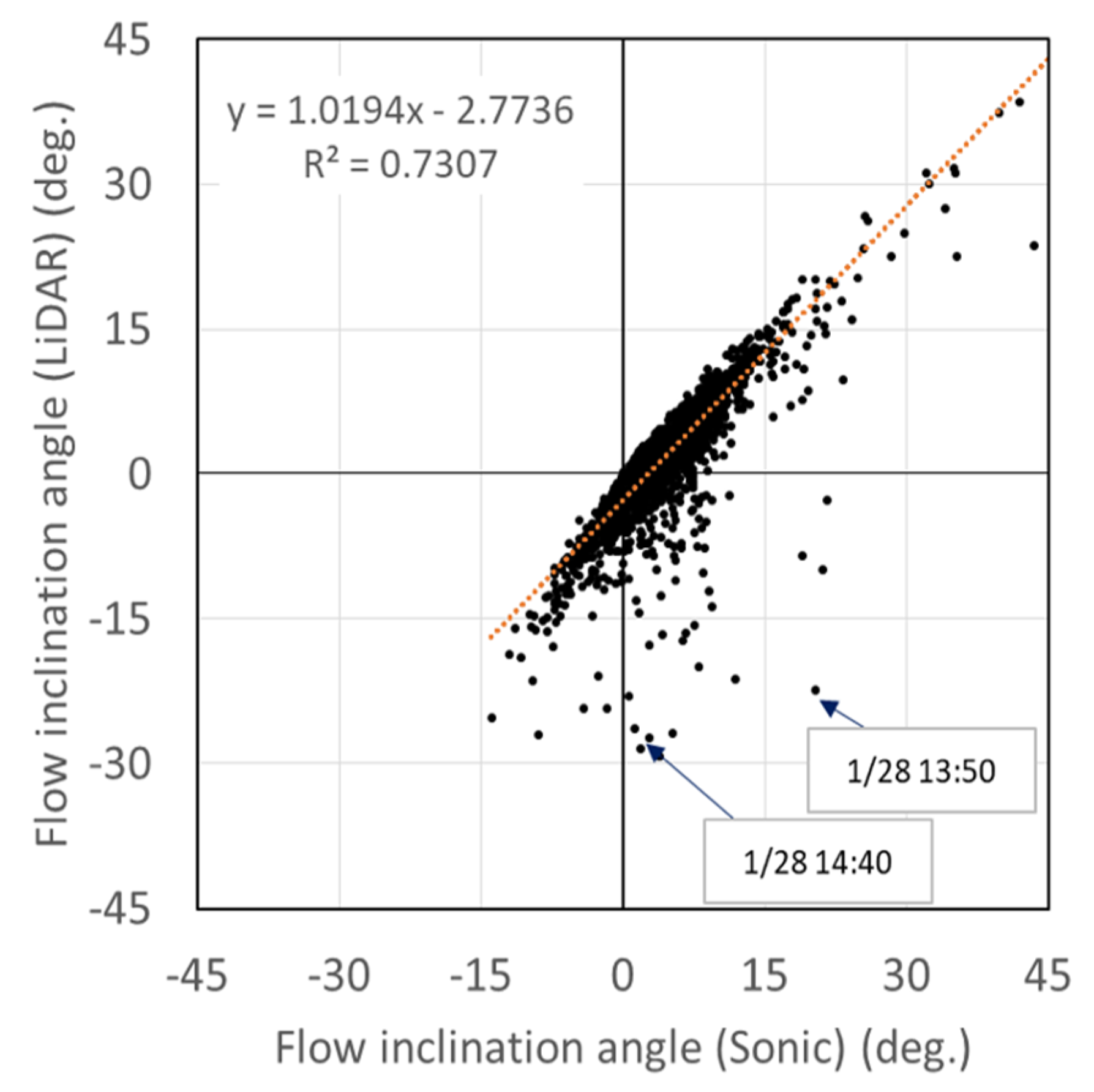
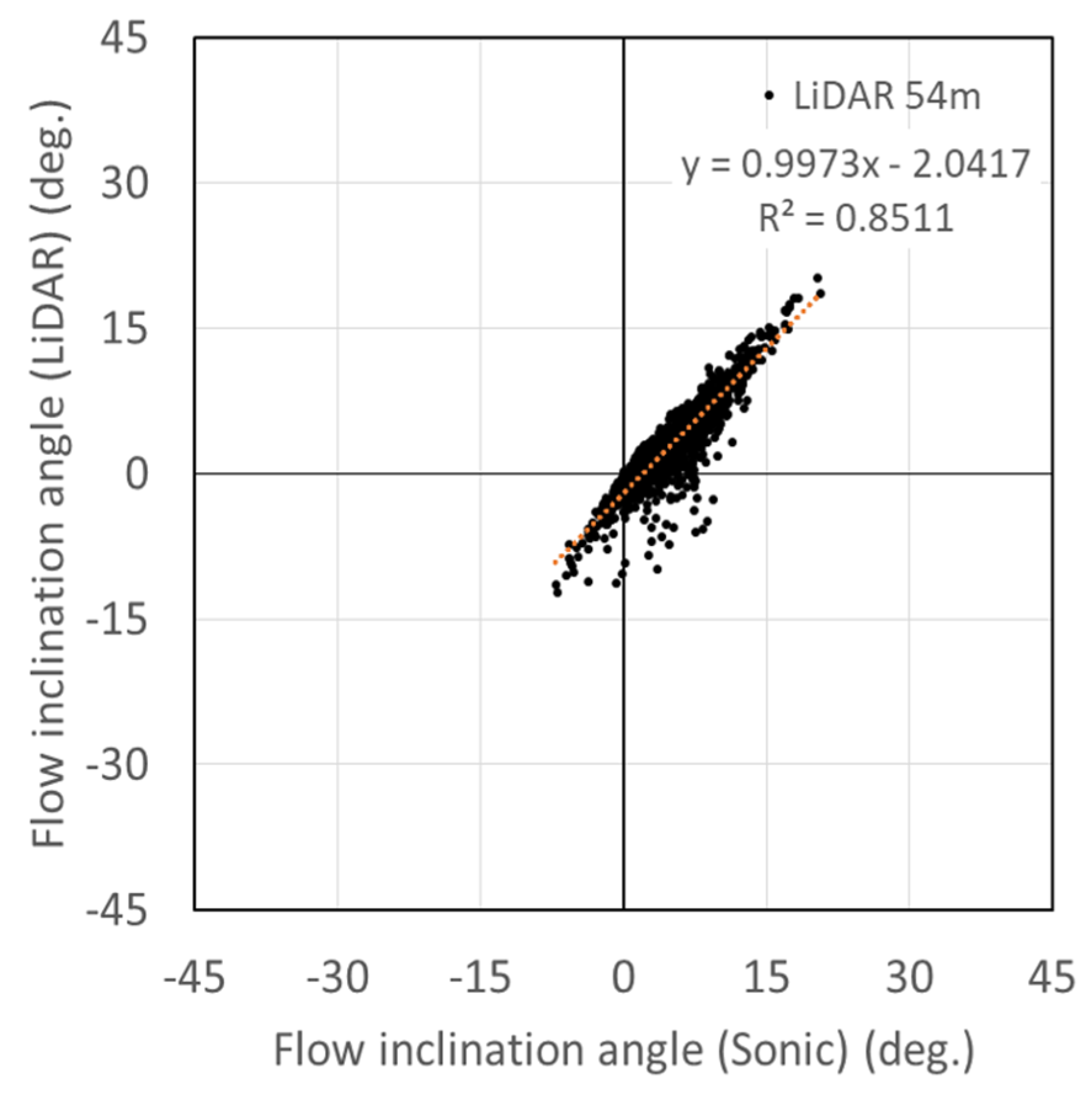
A comparison of the vertical wind speed and flow inclination angle measured with the LiDAR and the ultrasonic anemometer are shown in Figure 8 and Figure 9, respectively. The slope of the regression line is 0.899 for the vertical wind speed, indicating that the LiDAR underestimated the vertical wind speed compared to the ultrasonic anemometer. This disparity may be due to the difference in measurement principles; the ultrasonic anemometer employs point measurements, whereas the LiDAR measures the average wind speed value for a certain control volume in the sky. However, this effect was not considered to be significant in this study, because the vertical wind speed was measured directly using the LiDAR only in the LOS0 direction (Figure 1). It should also be noted that the vertical wind speed measured with the ultrasonic anemometer is not necessarily correct, because the measured vertical wind speed is affected by the anemometer housing and the arms that support the sensor. As an example, involving a large difference in the observed measurements, we focused on the measurement data collected on 28 January 2018, which includes the two sets of plot points shown in Figure 9. The time history of the 10 min average horizontal and vertical wind speeds measured on the same day are shown in Figure 10. Although the differences in horizontal wind speed obtained using the LiDAR and the ultrasonic anemometer are small, the difference in vertical wind speed was large from 13:00 to 15:00 on the same day. According to records obtained from an Automated Meteorological Data Acquisition System (AMeDAS) station nearby, the precipitation during the same period on this day was 0.0 mm, but the weather observed on that day was cloudy and snowy. Therefore, it is possible that an amount of snowfall that was less than the AMeDAS precipitation detection limit (0.5 mm) may have occurred, and this may have affected the measurements. Importantly, the data-acquisition rate of the LiDAR over the same time period was 100%, and there was no influence of statistical error due to a low data-acquisition rate. The 10 min average horizontal wind speed over the same time period ranges from 1.35 to 3.42 m/s, which is negligible for the design and operation of wind turbines on wind farms. Consequently, as shown in Figure 11, we only compared the flow inclination angle measured by the LiDAR and the ultrasonic anemometer for the datasets where the horizontal wind speed was at least 4 m/s. Using this minimum horizontal wind speed of 4 m/s, which corresponds to the turbine cut-in wind speed, the correlation improved, as shown by the slope of the regression line of 0.997 and the coefficient of determination (R2) of 0.851.
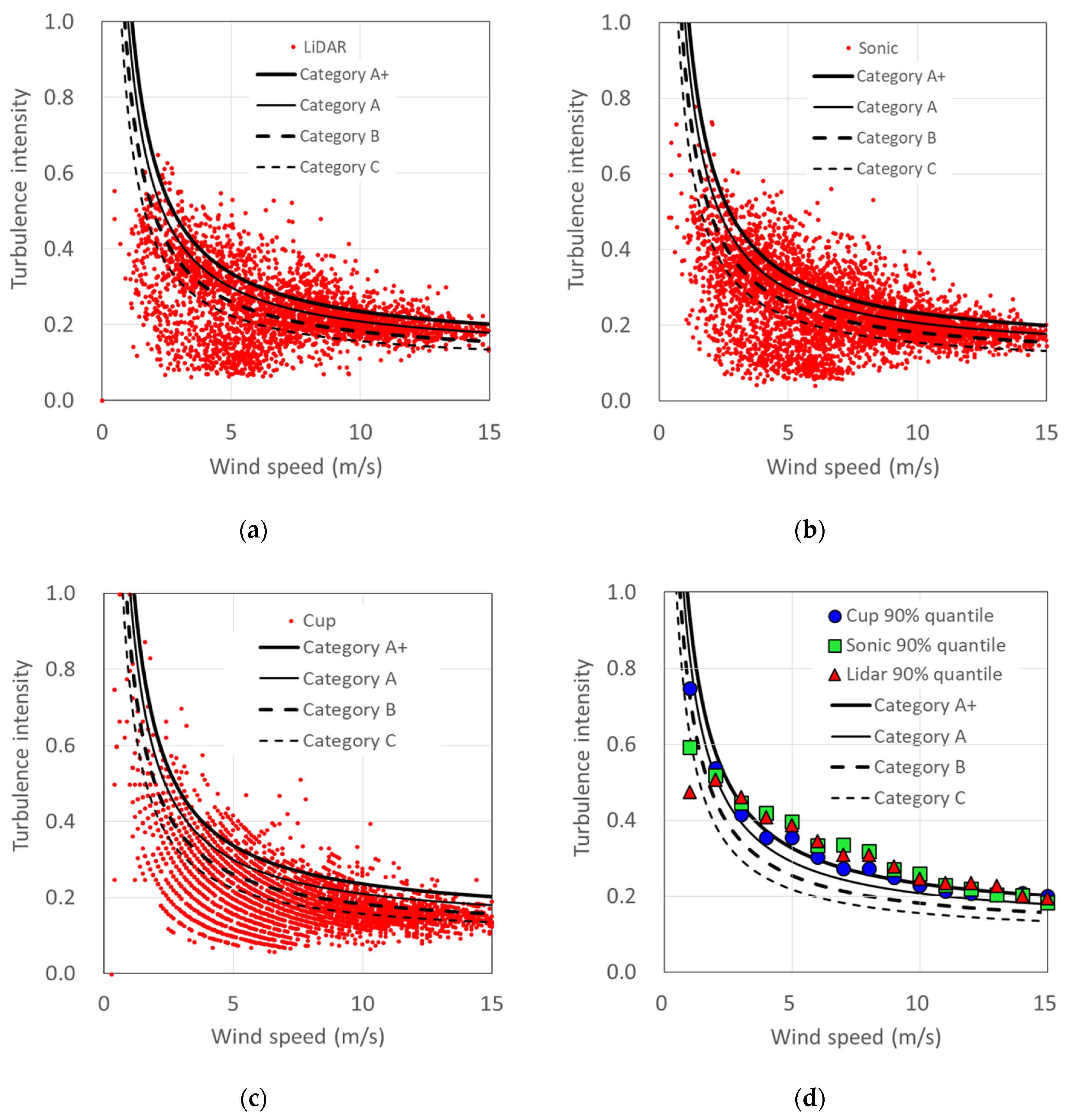
Figure 12 shows the results of the turbulence intensity measurements obtained by the LiDAR, the ultrasonic anemometer and the cup anemometer. Turbulence intensity (I) is calculated by
I = σ V ¯ ,
σ = 1 N T i = N t N t + T ( V i V ¯ ) 2 ,
V ¯ = 1 T t t + T V ( t ) d t = 1 N T i = N t N t + T V i ,
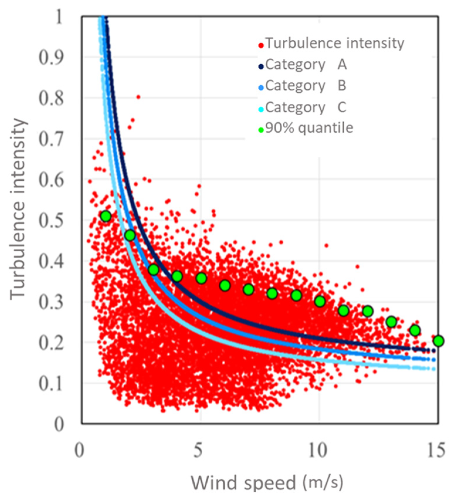
where V ¯ is the 10 min average horizontal wind speed, V(t) and Vi are the instantaneous horizontal velocity in the continuous and discrete form, T is the average time period (10 min in this study), and NT is the total number of data in the 10 min time period and σ is the turbulence standard deviation of the horizontal wind speed. The turbulence intensity results measured with the cup anemometer (90% quantiles, Figure 12d) at wind speeds ranging from 3 to 15 m/s indicate intensities corresponding to turbulence category A (Iref = 0.16; Iref is the expected turbulence intensity at the hub height with a 10 min average wind speed of 15 m/s) or even higher intensities exceeding turbulence category A+ (Iref = 0.18), according to the IEC 61400-1 Ed. 4 (2019) [19]. These high turbulence intensities indicate that the measurement site is located in highly complex terrains. The turbulence intensities measured with the LiDAR are typically greater than those measured with the cup anemometer and less than those measured with the ultrasonic anemometer. A previous study [5], which also used a pulsed LiDAR (Leosphere Windcube, Vaisala Oyj) system, found that the LiDAR tended to slightly overestimate turbulence intensities compared with a cup anemometer. Further, when the laser beam emission angle of the Windcube was changed from the standard 30° to 15° (complex terrain mode), in addition to using a continuous-wave LiDAR (ZX Lidars (formerly ZephIR Lidar), the turbulence intensities of both LiDARs were underestimated when compared to the cup anemometer [5]. Nonetheless, in the present study, the difference in the 90% quantiles of the turbulence intensities estimated using the LiDAR and the cup anemometer (Figure 12d) were less than the width of the turbulence categories in the IEC 61400-1 Ed. 4 (2019) [19]. In addition, the LiDAR measurements in this study were on the conservative side, because the LiDAR tended to slightly overestimate the turbulence intensity compared to the cup anemometer. These results suggest that the LiDAR can be used to evaluate turbulence intensity, to some extent, even in complex terrains.
In addition, the results of the present study show that the LiDAR measurements of wind characteristics generally show good agreement with those measured using a conventional cup anemometer and ultrasonic anemometer. In the measurement conditions encountered in this study, we believe that the vertical-profiling LiDAR is capable of sufficiently evaluating wind characteristics. However, it should be noted that the obtained results are specific to the current measurement conditions (such as the positioning of the LiDAR in complex terrains and the type of LiDAR equipment used). In order to draw universal conclusions, it will be necessary to undertake more measurements and demonstration cases in areas with complex terrains.

3.2. Measurements on the Wind Farm

3.2.1. Outline

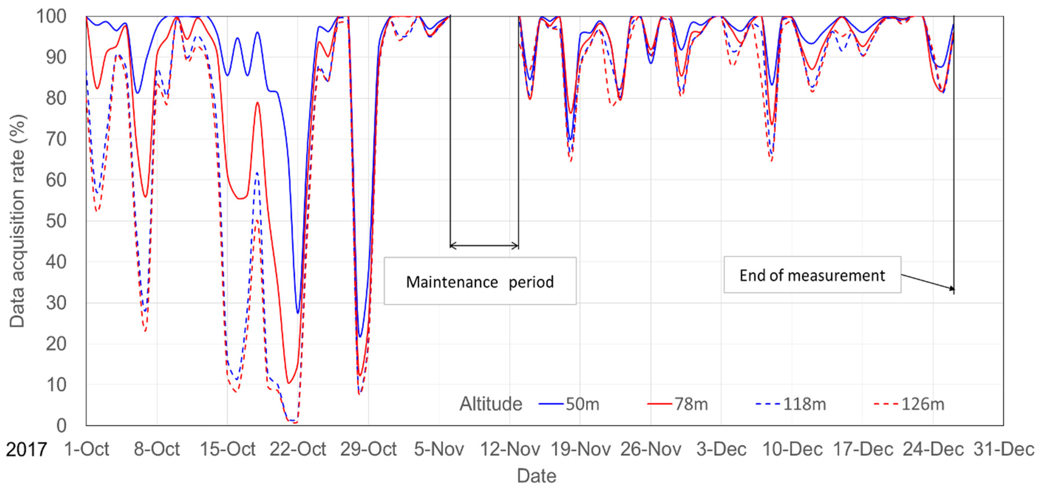
Figure 13 shows the changes in the data-acquisition rate in LiDAR measurements over time at the position between turbines for representative heights of 50 m (minimum measurement height), 78 m (turbine hub height), 118 m (maximum turbine rotor height) and 126 m (maximum measurement height) AGL. As in the case of the measurements at the mast position (Figure 6), the data-acquisition rate is highest closer to the ground. However, here there were cases in which the data-acquisition rate was extremely low, i.e., 50% or less, for all heights. In October 2017, the measurement site experienced heavy rain as Typhoons No. 21 (Lan) and No. 22 (Saola) struck Japan. Presumably, this heavy rain overwhelmed the capability of the wiper on the LiDAR measurement window, leaving the window obscured by raindrops and resulting in a marked reduction in the data-acquisition rate.

3.2.2. Influence of Turbine Blade Interference on LiDAR Measurements

Laser beams emitted by the LiDAR may be blocked by the turbine blades, resulting in measurement failure and degradation in the data-acquisition rate. Moreover, there was a concern that the spatial uniformity in the wind speed, which is assumed to be uniform by the LiDAR, may not were maintained due to wakes on the downstream side of the turbine and the stagnation effect on the upstream side of the turbine. Together, these factors may have adversely affected the accuracy of the wind speed estimates of the LiDAR. To address these issues, the study examined whether the data-acquisition rate and the wind speed measurement accuracy were adversely affected by interference between the LiDAR and the wind turbine blades. Specifically, a detailed analysis of the LOS wind speeds measured by the LiDAR was performed.
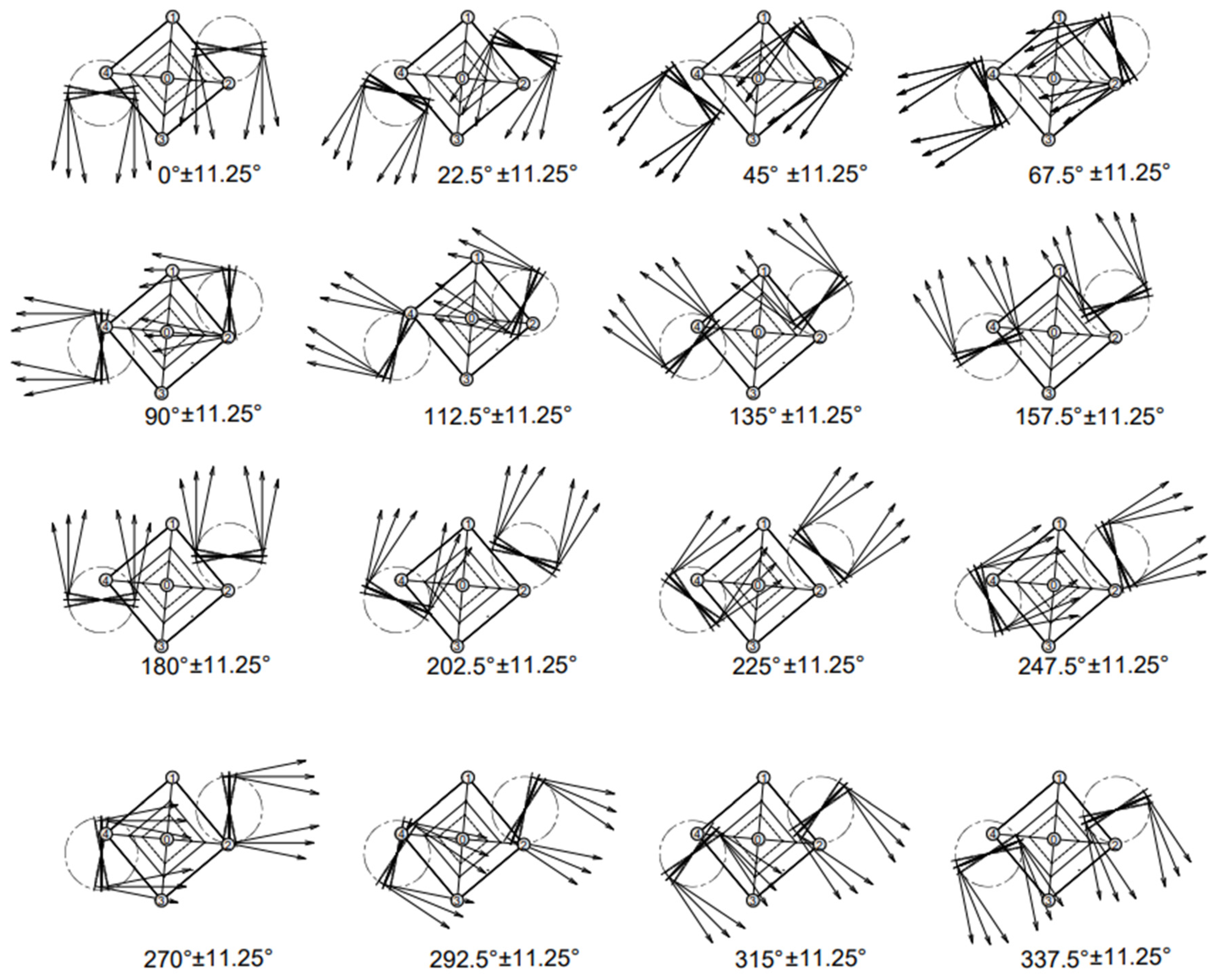
Figure 14 shows the results of a geometric analysis of the possibility of interference between the LOS from the LiDAR and the wind turbine blades for each of the 16 wind direction sectors. Figure assumes that each turbine faces the wind direction (±11.25°). The results of the geometric analysis indicate that the blades may have interfered with the LiDAR’s LOS in the wind direction sectors of 117° to 148° and 297° to 328°.
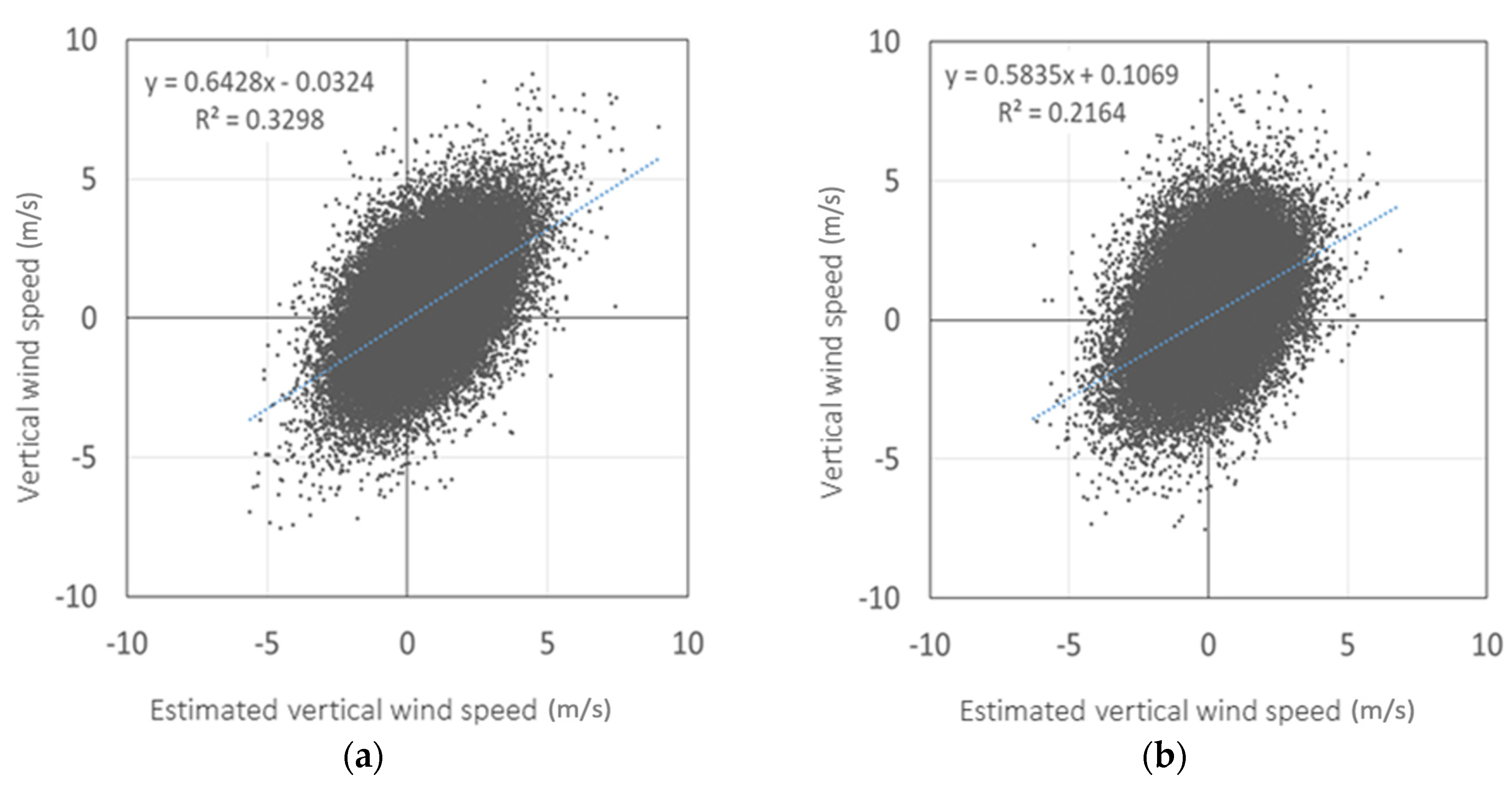
Furthermore, in and around these wind direction sectors, even if the turbine blades do not directly interfere with laser beams, they may pass near enough to the LOS to induce extreme changes in vertical wind speeds around the control volume. To investigate this possibility, Figure 15 compares a case in which the instantaneous vertical wind speed is directly measured in the LOS0 direction (Figure 1), with cases where it is calculated from LOS1 and LOS3 and from LOS2 and LOS4. The vertical wind speeds calculated from LOS1 and LOS3 and from LOS2 and LOS4, do not coincide exactly with the vertical wind speed measured directly from LOS0; also, the data show some variation, which may be caused by deviation in the horizontal position for evaluating vertical wind speed. Moreover, because the pulsed LiDAR used in this study emits laser beams intermittently by switching between the five directions (LOS0 to LOS4) every 0.4 sec, there is a sampling time lag of about 1 to 2 s between the directly measured and estimated vertical wind speeds; this time lag may also be a cause of the variation found in Figure 15. In any case, the calculated values of vertical wind speed in Figure 15 show no excessive up-flow or down-flow which would be suggestive of blade interference. Therefore, we consider that the turbine blades do not have a significant adverse effect on the LiDAR beams.
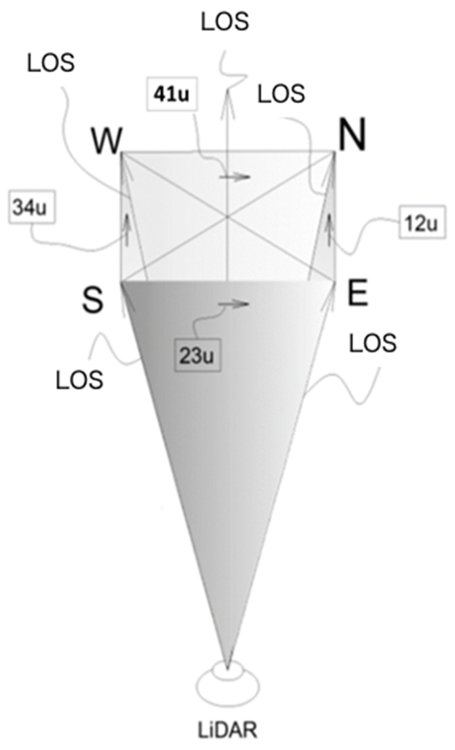
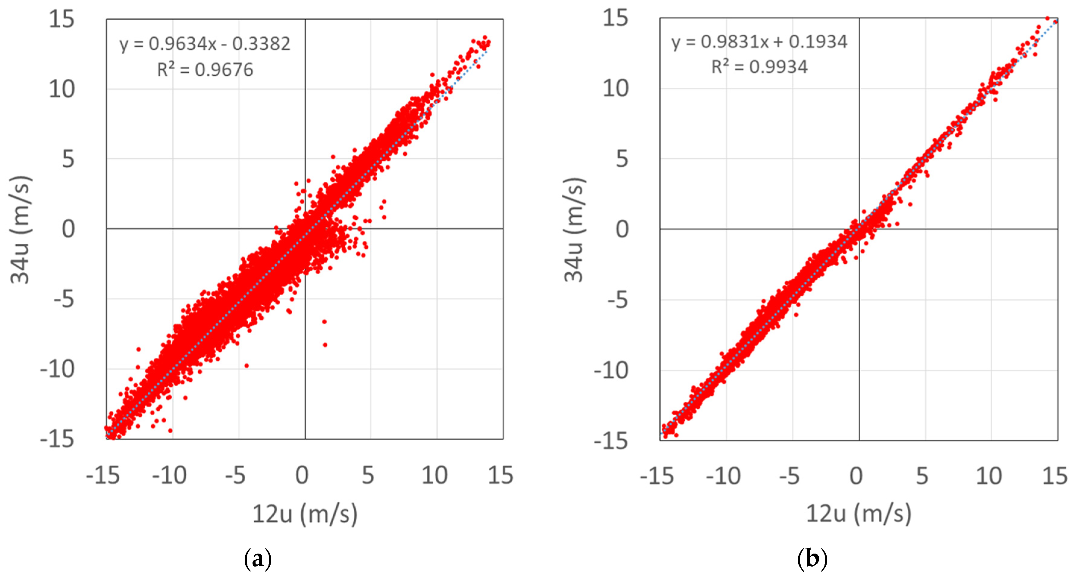
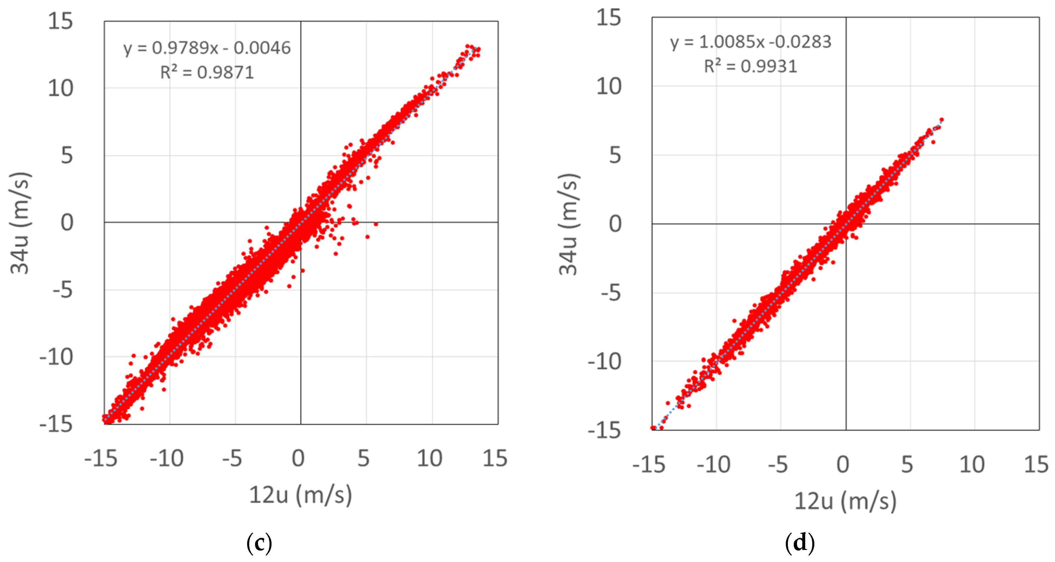
As shown in Figure 16, the horizontal wind speed within the plane formed by LOS1 and LOS2 is denoted as 12u. Those within the other planes are analogously denoted as 23u, 34u and 41u. When the horizontal wind speed is uniform within the horizontal plane at the height above ground where measurements are taken, 12u and 34u (and 23u and 41u) should be exactly the same. When there is a significant difference in either comparison, the assumption of spatial uniformity in the wind in the LiDAR measurement plane does not hold. The difference may be explained by the effects of wakes and stagnation caused by the turbines, as well as airflow distortion due to the complexity of the terrain. Figure 17 shows the nonuniformity in the wind speed within the horizontal planes, as evaluated through a comparison of 12u and 34u (10 min averages in each case). For comparison, measurements obtained on the relatively flat terrain at the demonstration field at the Fukushima Renewable Energy Institute of the National Institute of Advanced Industrial Science and Technology (FREA) are also shown. The measurement method and terrain conditions are similar to those obtained in a previous investigation by Goit et al. [11]. Comparison of the 12u–34u relationship in the mast position and at the flatter FREA site shows similar data variation (the coefficient of determination R2 being 0.993 or higher in both cases), indicating that nonuniformity in the horizontal wind speed within the horizontal plane does not have a prominent effect. The variation at the position between turbines is slightly larger, with a lower R2 value of 0.987 compared with 0.993, but this variation is not marked. However, the data variation at the position between turbines becomes noticeably larger at a measurement height of h = 78 m (turbine hub height), which has an R2 value of 0.968 compared with 0.987, indicating greater nonuniformity in the horizontal wind speed at that height. The same pattern is observed in the comparison between 23u and 41u, which suggests that the turbine rotors have an effect on the nonuniformity in the horizontal wind speed.
Although the difference between 12u and 34u (and between 23u and 14u) indicates nonuniformity in the horizontal wind speed, the magnitude of the difference cannot be used as a universal index, as it depends on the wind direction. For a more universal index of the spatial uniformity in wind speed that is independent of the wind direction, we consider that the vector comprised of (12u–34u) and (41u–23u) represents the nonuniformity of wind speed within a given horizontal plane. This vector, referred to as the nonuniformity wind velocity vector (UNU), is given by:
| U N U | = ( 12 u 34 u ) 2 + ( 23 u 41 u ) 2   ,
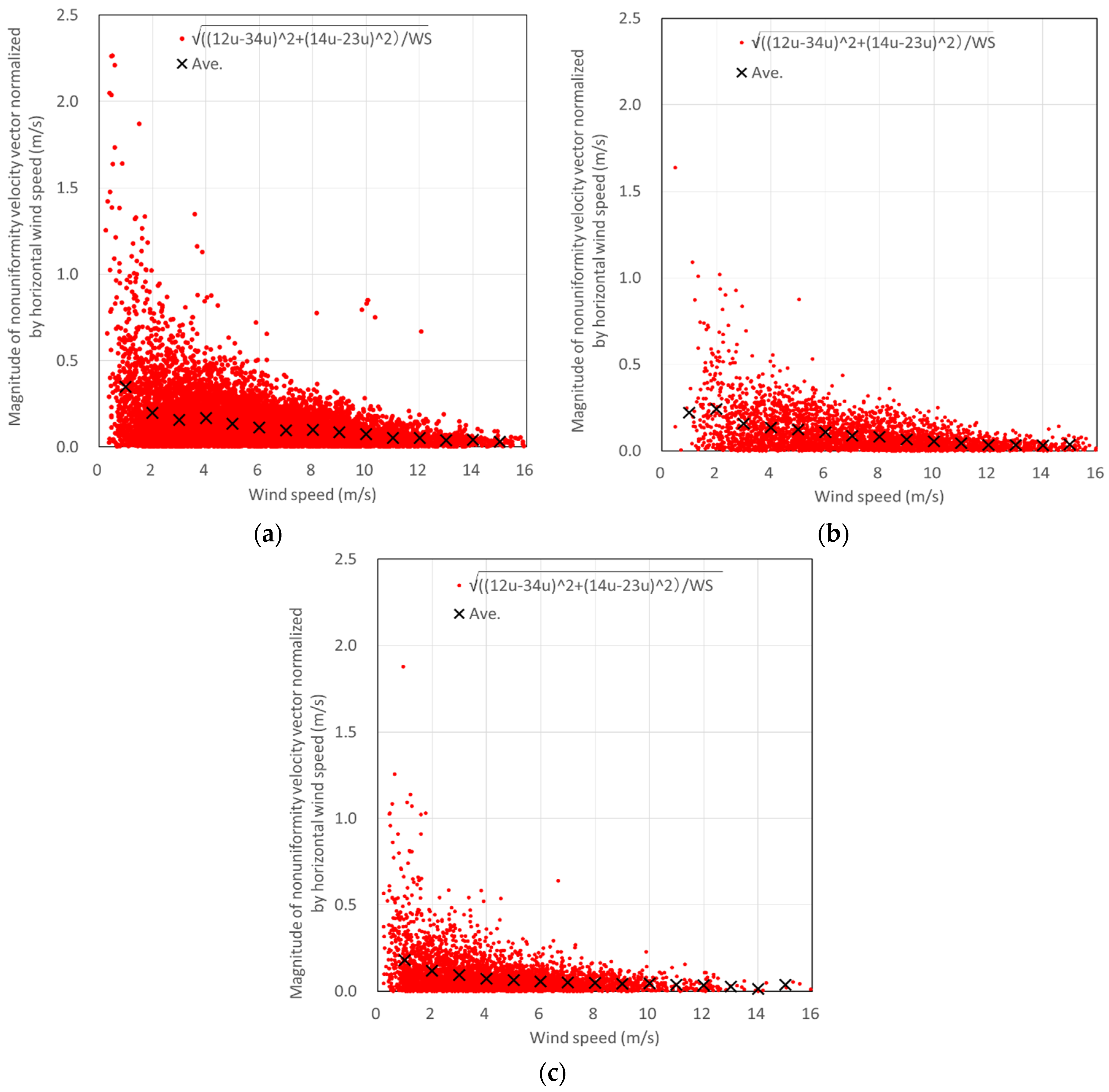
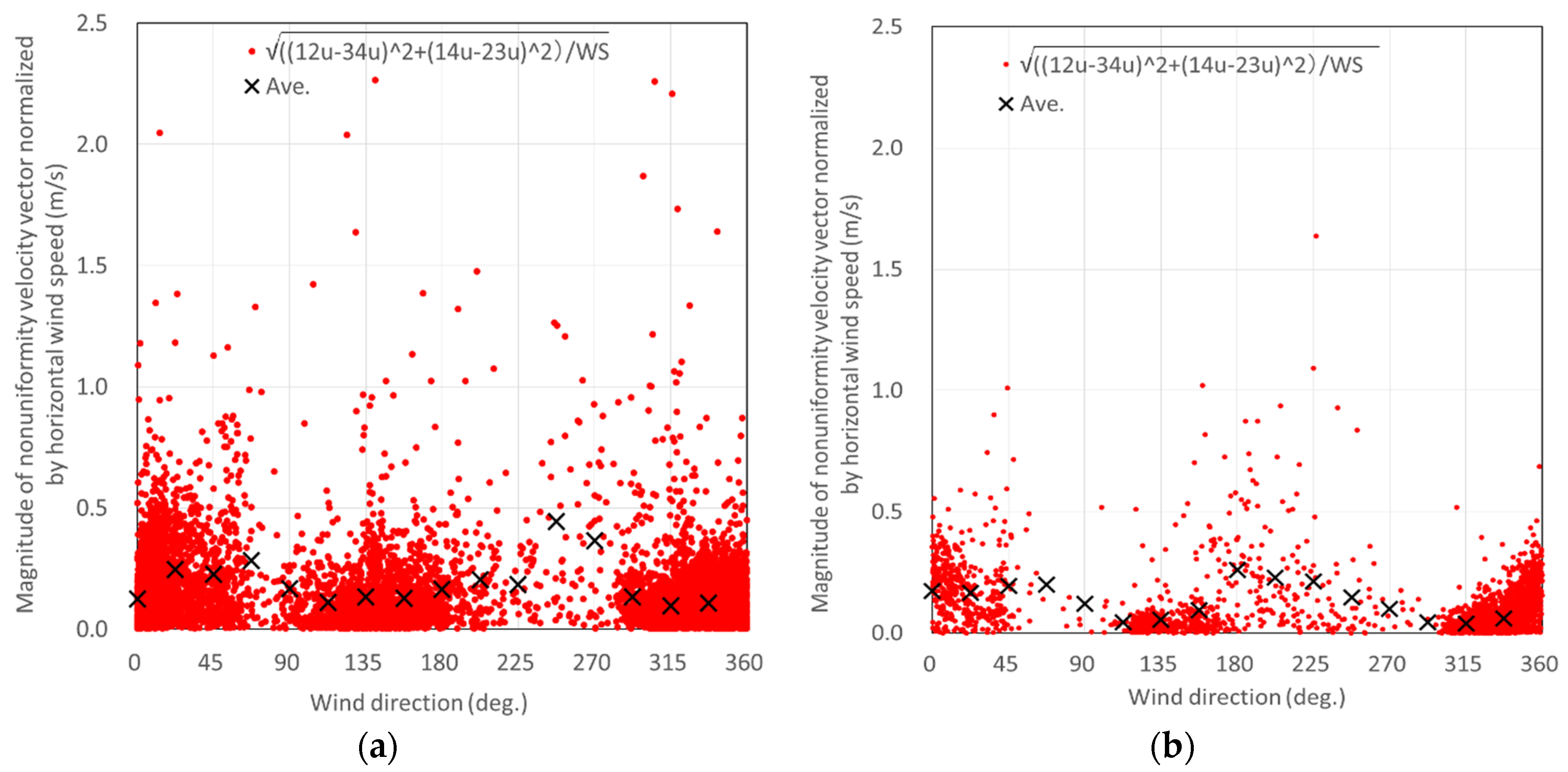
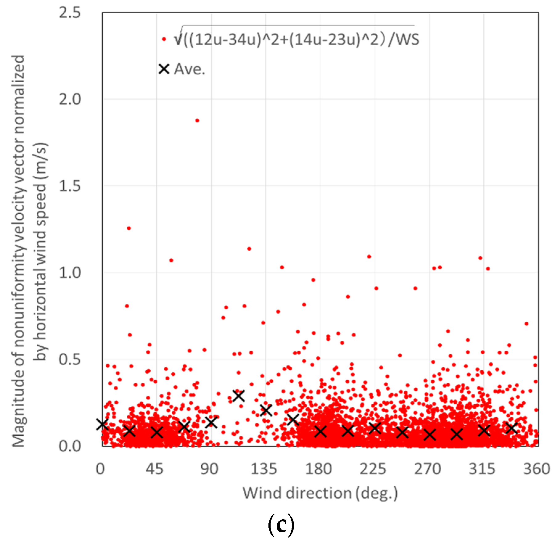
where, | U N U | indicates the magnitude of spatial nonuniformity in the wind speed (hereinafter, SNWS) within the horizontal plane. Figure 18 and Figure 19 shows the quantity obtained by normalizing | U N U | by the horizontal wind speed at the corresponding time (hereinafter referred to as “normalized | U N U | ”), plotted against the horizontal wind speed and wind direction, respectively. The higher the wind speed, the lower the normalized | U N U | and thus the lower the effect of nonuniformity, which leads to a smaller error in the wind speed evaluated with the assumption of spatial uniformity in the wind speed in vertical-profiling LiDAR measurements (Figure 18). In comparing the three positions (the position between turbines, the mast position and the FREA site), the SNWS is slightly greater at the mast position and the position between turbines than at the FREA site, which is on the flattest terrains.
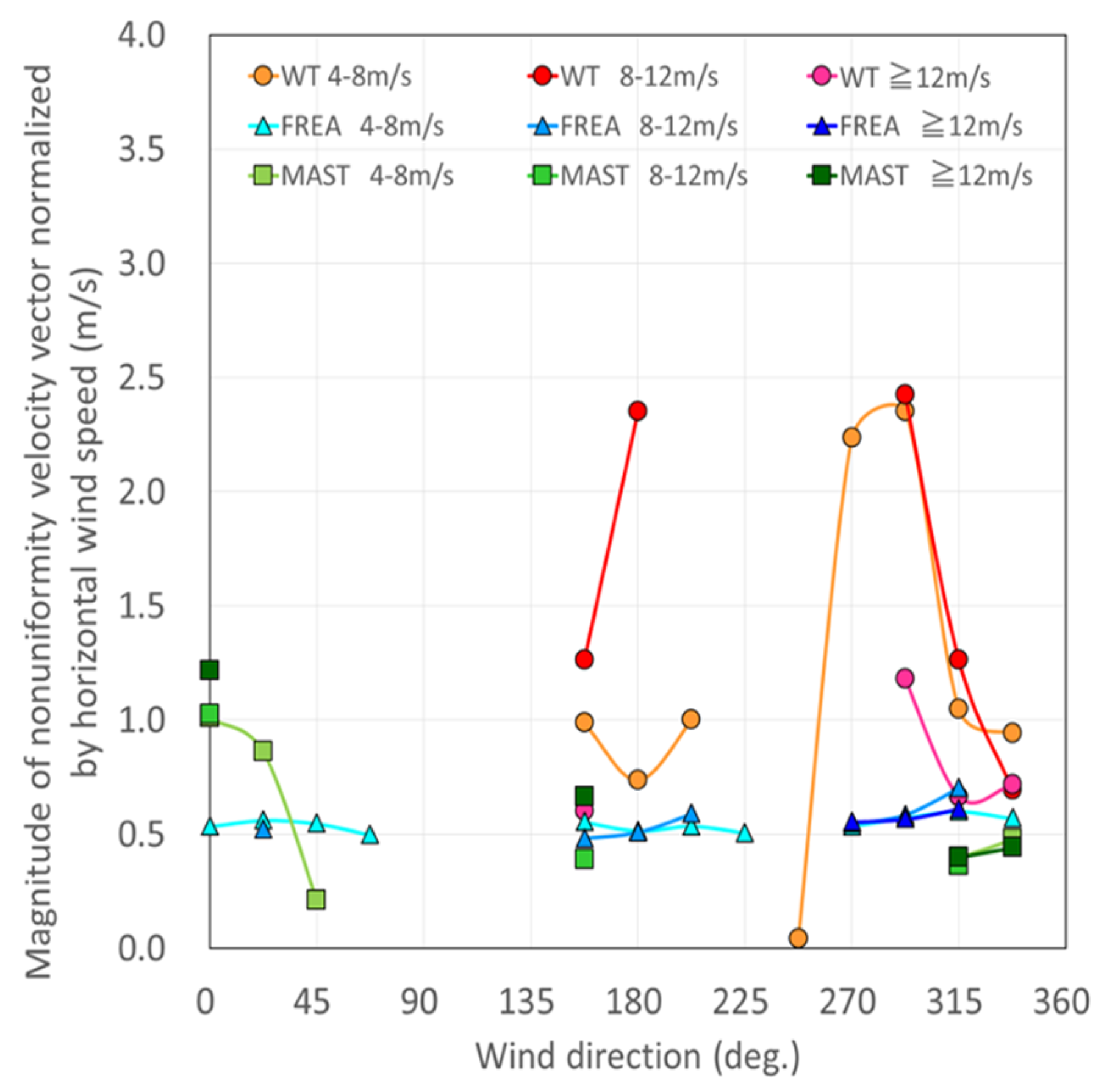
For different wind directions, the variation in the bin average of normalized | U N U | at the FREA site and the mast position is generally small, whereas the bin average at the position between turbines is generally large. This may be partly due to the increased SNWS due to the presence of the turbines (Figure 19a,b). While the dependence of the SNWS on the wind direction is small at the FREA site (the wind direction bin average of normalized | U N U | is about 0.1), there are instances of large SNWS depending on the wind direction at the turbine position and the mast position. This may be due to the complexity of the terrain on the upstream side of the measurement location or the presence of the turbines. To eliminate as much as possible of the potential effect of differences in the wind speed range in Figure 19a,b, | U N U | values obtained for different wind speed ranges (4–8 m/s, 8–12 m/s and 12 m/s or more) are plotted against the wind direction in Figure 20. The normalized | U N U | values, which tend to increase slightly with the wind speed, are generally on the order of 0.5 m/s at both the mast position (denoted by squares) and the FREA site (denoted by triangles). At the position between turbines, the SNWS is generally greater, with normalized | U N U | values of around 1.0 (m/s); this may reflect the presence of the turbines (wakes or stagnation on the upstream side of the turbine rotor).

3.2.3. Wind Characteristics at the Measurement Location

Figure 21 shows the turbulence intensity at the position between turbines, measured and evaluated by the LiDAR system. The LiDAR wind speed measurement and evaluation principle indicates that the measurement accuracy of turbulence intensity is insufficient, and actual demonstration also indicated insufficient accuracy for quantitative evaluation [4]. It is therefore necessary to limit our discussion here to a relative evaluation. Compared with the turbulence category curve defined in IEC 61400-1 Ed. 4 (2019) [19] and the turbulence intensity at the mast position in Figure 12, the turbulence intensity tends to be large over the entire wind-speed range. This can be attributed not only to topographical factors, but also to the wakes caused by nearby turbines.
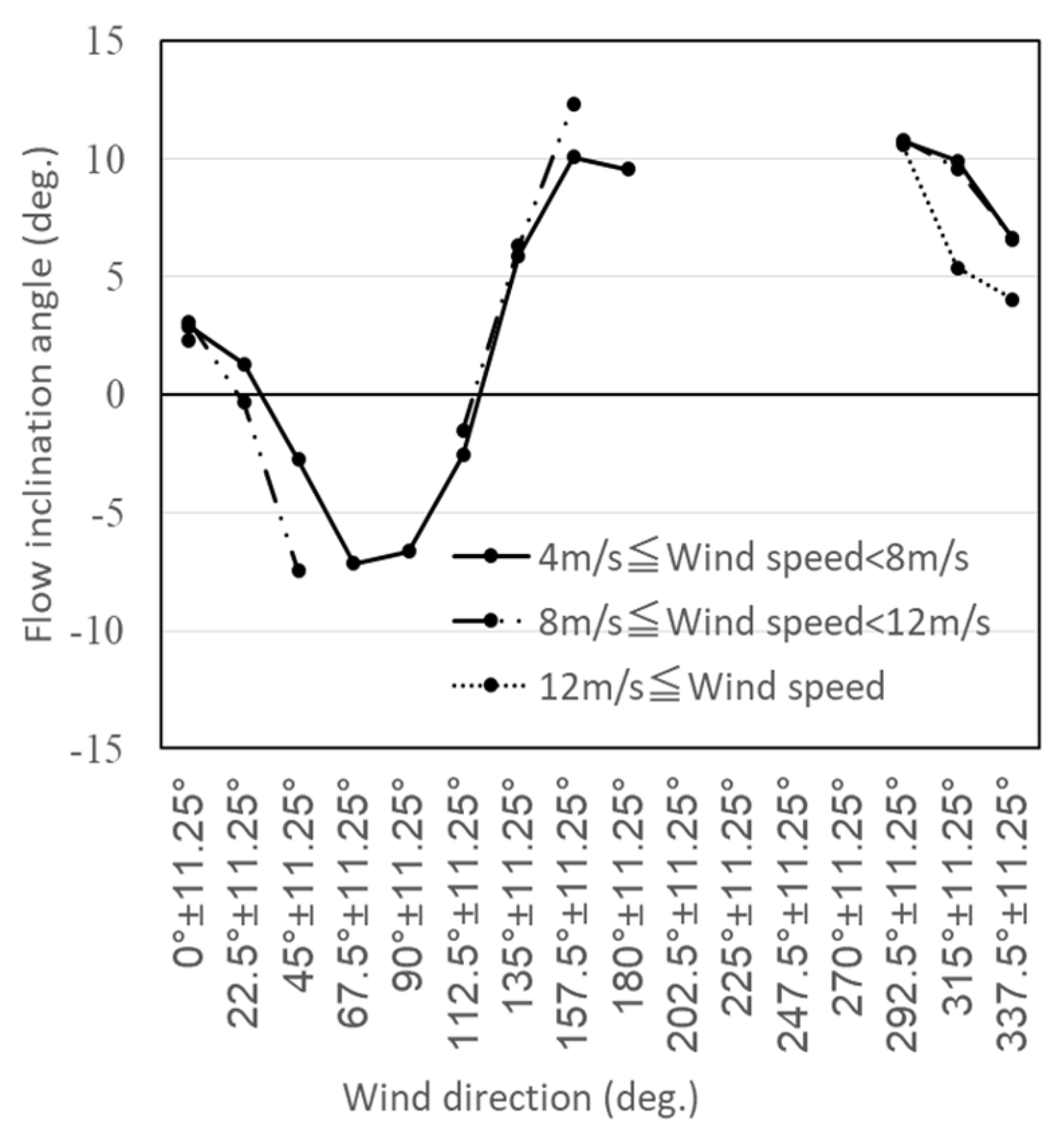
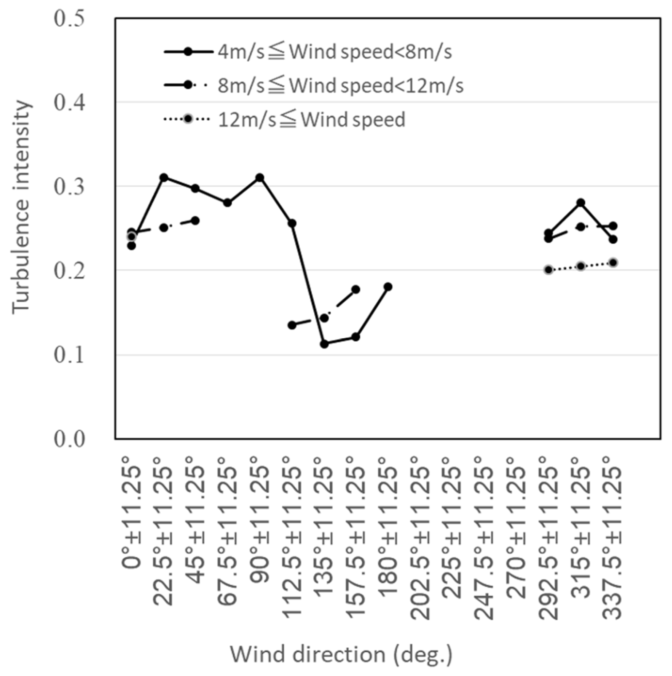
Figure 22 and Figure 23 show the flow inclination angle and turbulence intensity, respectively, for the 16 wind directions (wind direction bin averages), for the average wind speed ranges of 4–8 m/s, 8–12 m/s and 12 m/s or more. While the flow inclination angle is about 6° and the turbulence intensity about 24% in the prevailing north-northwest wind direction (337.5 + 11.25°), flow inclination angles exceeding 10° and turbulence intensities exceeding 30% are found in some wind directions. These data reflect the influence of the complex terrain.
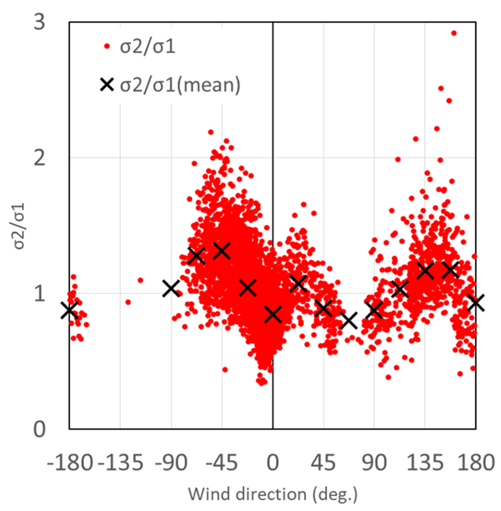
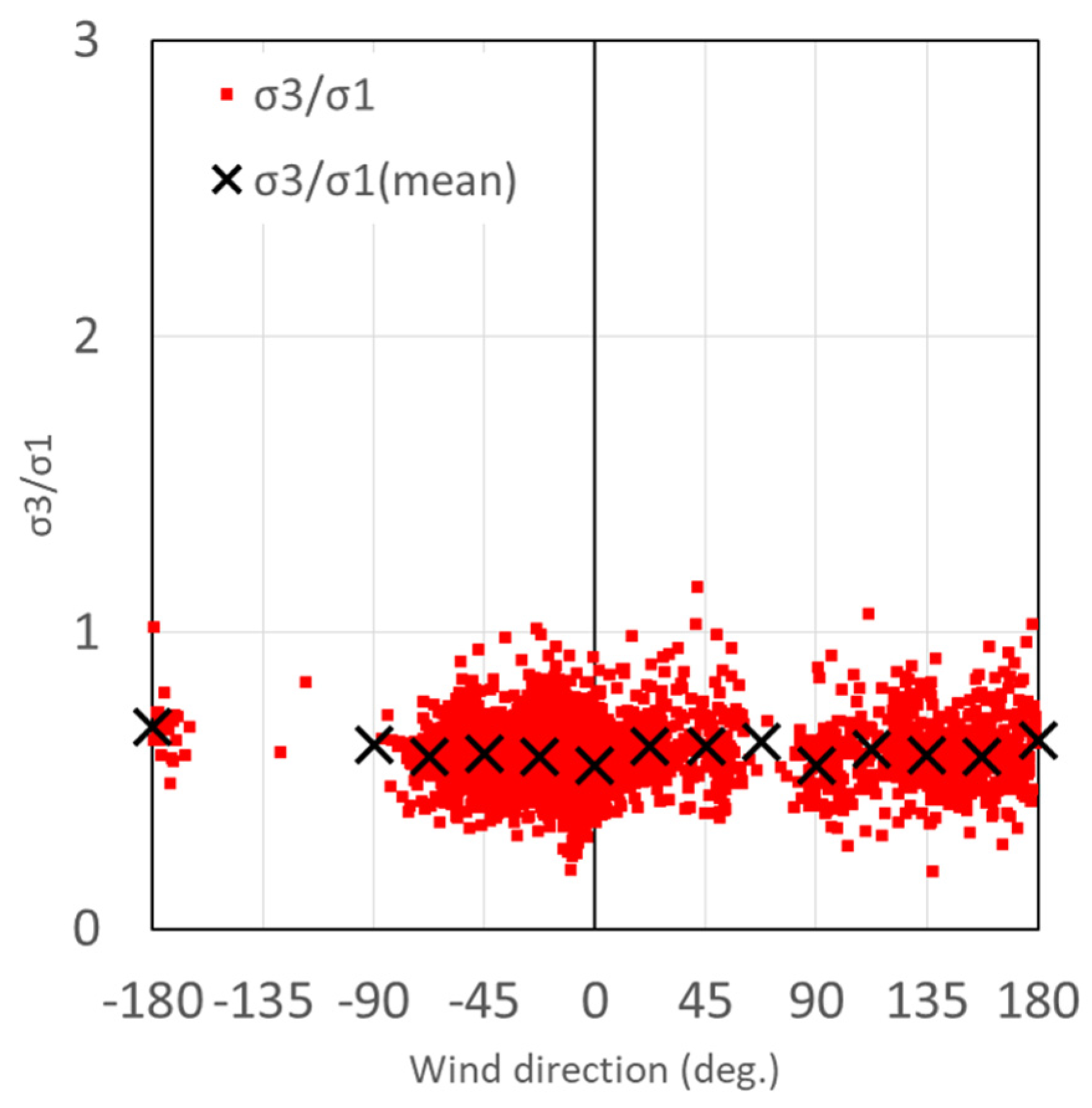
Figure 24 and Figure 25 show the ratios of the three components of the turbulence standard deviation σ21 and σ31 (referred to as “turbulence structure” in IEC 61400-1 Ed. 4 (2019) [19]), respectively, plotted against the wind direction for the average wind speed range of 4 to less than 8 m/s. Turbulence standard deviations (σi, i = 1, 2, 3. 1: longitudinal direction, 2: lateral direction. 3: upward direction) are standard deviations of the longitudinal, lateral or upward component of the turbulent wind velocity. The values of σ21 = 1.0 and σ31 = 0.7 are postulated for sites with high terrain complexity (Category H) in IEC 61400-1 Ed. 4 (2019) [19]. While the σ21 is greater than unity for some wind directions, further detailed investigations are required, as the present results may have been affected by various factors such as the wakes caused by nearby turbines. On the other hand, σ31 is as low as about 0.7 or less, for almost all directions. As the measurement location was situated on a ridge, it is conceivable that the upward turbulence standard deviation σ3 was reduced by the flow contraction effect on the ridge.
Figure 26 shows the wind direction bin-averaged wind-shear profiles for different wind directions and four hub-height 10 min average wind speed ranges. Wind speed is normalized by hub-height wind speed in Figure 26. No profiles mean that there were not enough 10 min average wind-shear samples in the wind direction bins for the wind speed ranges. While the difference in wind-shear profiles between different wind speed ranges in each wind direction (Figure 26b–d) is small, it differs among the different wind directions. The wind speed is increased with increasing measurement height at wind direction 270° ± 11.25° (Figure 26a). Conversely, the wind-shear profiles for 292.5° ± 11.25°, 315° ± 11.25° and 337.5° ± 11.25° (Figure 26b–d) are more vertical and concave-shaped, with a maximum wind speed deficit at approximately 10 m above the rotor hub height. Although it is likely that these concave-shaped wind-shear profiles are caused by the nearby wind turbine wakes (Figure 2 and Figure 14), it is also suspected that the flow over the ridge is accelerated near the terrain surface by the flow contraction effect on the ridge.
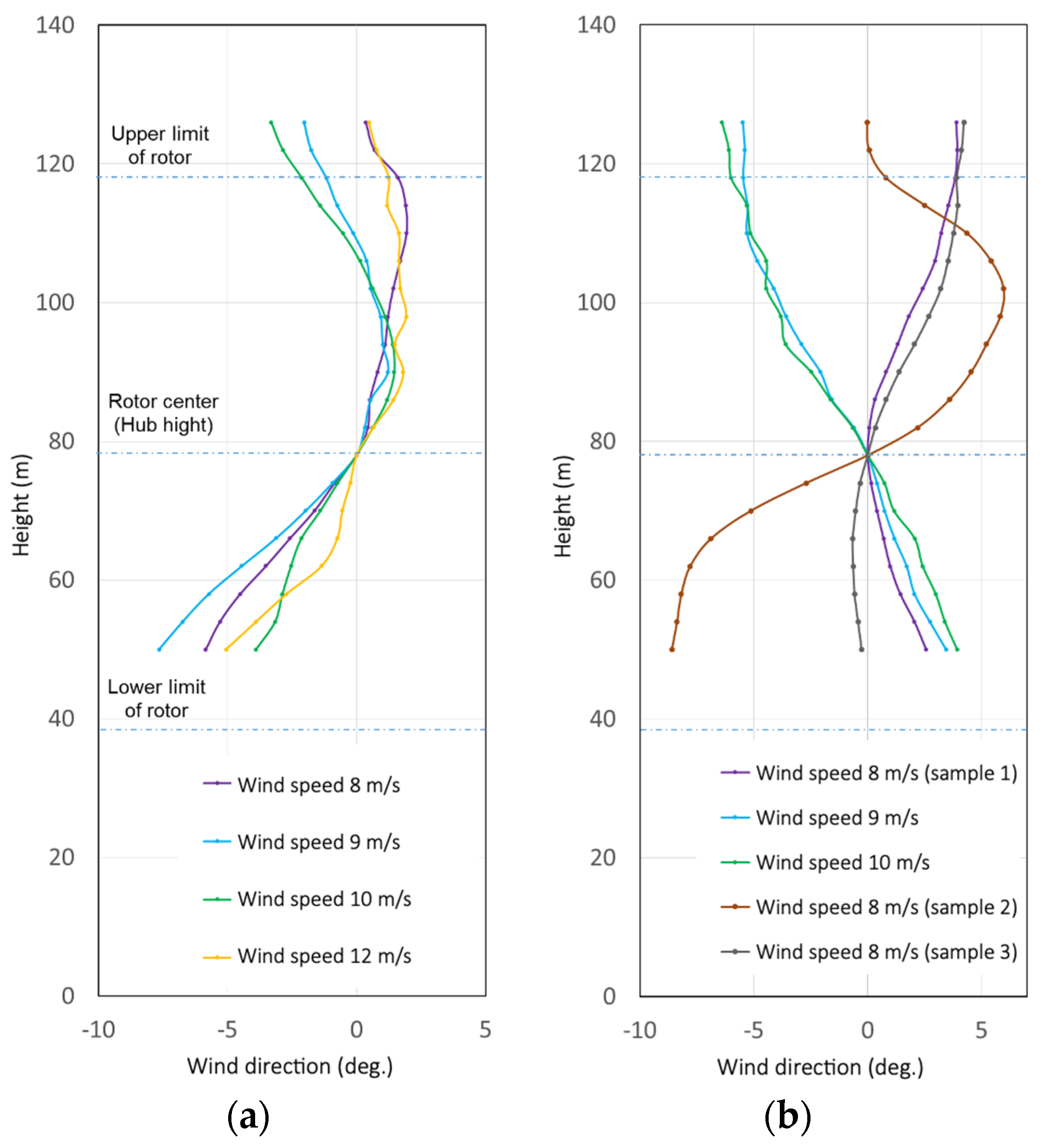
Figure 27 shows the representative 10 min average wind-veer profiles for the different hub-height 10 min average wind speeds between 8 and 12 m/s in the wind direction bins of 337.5° ± 11.25° (the dominant wind direction) and 157.5° ± 11.25° (the second most dominant wind direction). Wind direction is normalized by hub-height wind direction in Figure 27. All of the wind-veer profiles in wind direction bin 337.5° ± 11.25° are similar, independently of wind speed (Figure 27a. In addition, the wind-veer profiles in wind direction bin 157.5° ± 11.25° change dramatically between 8 and 9 m/s; further, there is also considerable variation in three wind-veer profiles with a hub-height wind speed of 8 m/s. We suggest that flows from that direction have complex wind characteristics which changed significantly in response to wind speed. These complex wind characteristics cause nonuniformity in space and fluctuation in time of flow over the rotor plane, resulting in an increase in fluctuating wind-loading to the wind turbine rotor blades. This is thus very useful for wind farm operators and wind turbine manufacturers to be able to capture complex wind characteristics on wind farms located in areas with complex terrains using LiDAR. However, due to the considerable uncertainties associated with LiDAR measurements at sites with complex terrains, it is necessary to accumulate more measurements in such areas to draw more universal conclusion.

4. Conclusions

With the ultimate goal of elucidating the characteristics of downwind turbines in complex terrains, we measured the wind characteristics on a wind farm using a vertical-profiling LiDAR and obtained the following results.
In complex terrains, the correlation between the horizontal wind speed measured with a vertical-profiling LiDAR and with a cup anemometer was as good as the correlation between the horizontal wind speed measured with the ultrasonic anemometer and cup anemometer. The flow inclination angle measured with the vertical-profiling LiDAR agreed well with that measured with the ultrasonic anemometer, except in the low wind-speed range of less than 4 m/s. These findings indicate that vertical-profiling LiDARs may be moderately useful for evaluating the flow inclination angle. The LiDAR tended to slightly overestimate the turbulence intensity compared with the cup anemometer and underestimate the turbulence intensity compared with the ultrasonic anemometer. The difference between the LiDAR and cup anemometer measurements of turbulence intensity in the wind speed range of 4–16 m/s was less than the width (Iref = 0.02) between the turbulence categories in IEC 61400-1 Ed. 4 (2019) [15] and the LiDAR measurement was on the conservative side because it tended to overestimate the turbulence intensity when compared with the cup anemometer. These results suggest that LiDARs can evaluate turbulence intensity to some extent, even in complex terrains. It should be noted, however, that the obtained results are specific to the measurement conditions of the study (such as the location of the LiDAR in the complex terrain and the type of LiDAR used). To draw universal conclusions, it is necessary to accumulate more measurements in complex terrains.
There is some concern regarding the application of LiDAR measurements to wind farms in complex terrains. Specifically, it is considered that the accuracy and reliability of LiDAR-based wind measurements are adversely affected by airflow distortion caused by the complexity of the terrain, turbine wakes, and stagnation effects on the upstream side of the measurement location, and the effect that these factors have on the assumption of spatial uniformity in wind speed. To address these issues, this study examined whether the data-acquisition rate and wind speed measurement accuracy were adversely affected by interference between the LiDAR and the wind turbines by performing a detailed analysis of the LOS wind speeds measured by the LiDAR. Geometric analysis—with the LiDAR located between two turbines separated by only 2D (D: diameter of turbines)—indicated that the turbine rotor may have interfered with the LiDAR LOS. However, the measurement results showed no significant decrease in the data-acquisition rate in specific wind directions that may cause rotor-based interference with the LiDAR LOS, indicating that the effect of interference was minimal. We have also proposed an index for assessing the extent of spatial nonuniformity in the wind speed, based on the LOS wind speeds on a measurement plane above the LiDAR. We found this index to be effective and used it to estimate spatial nonuniformity in the wind speed increased due to the topographic complexity on the upstream side of the measurement location and the turbine wakes. By using the LiDAR to evaluate a variety of wind characteristics on a wind farm in complex terrains, we demonstrated that it is possible to evaluate, to some extent, the wind characteristics that are important for wind turbine design and wind farm operation. These characteristics include the flow inclination angle, turbulence intensity, turbulence standard deviation ratio, wind shear and wind veer, for different wind directions. However, our results should be interpreted with caution because they are affected by site-specific attributes, such as the complexity of the terrain, wakes from nearby turbines and stagnation on the upstream side. Nevertheless, it was demonstrated that LiDAR can be used, to some extent, to measure wind characteristics on a wind farm in complex terrains in a way that considers the effect of wind directions with large spatial nonuniformity index values. To draw universal conclusions, it will be necessary to accumulate additional measurements in complex terrains. Investigation on relationship between the wind characteristics and the downwind turbine characteristics will be reported in our future work.

Author Contributions

T.K., K.S., S.S. and H.K. developed the idea, carried out the study, prepared the models, analyzed the corresponding results and wrote the paper. Y.O., K.K. and E.F. contributed by drafting the paper and performed critical revisions. All authors organized and refined the manuscript to its present form. All authors have read and agreed to the published version of the manuscript.

Funding

This study was conducted as part of a collaborative project between Hitachi, Ltd. and AIST entitled, “Research on the up-flow wind flowing into downwind turbines and the power output characteristics of turbines.”

Acknowledgments

Our LiDAR measurements were supported by the wind farm operator. We would like to express our gratitude to all concerned.

Conflicts of Interest

The authors declare no conflict of interest.

Abbreviations

AGLAbove ground level
CFDComputational fluid dynamics
LiDARLight detection and ranging
LOSLine-of-sight
SNRSignal-to-noise ratio
SNWSSpatial nonuniformity in the wind speed

References

  1. New Energy and Industrial Technology Development Organization (NEDO) Project Success Stories, From Remote Island Wind Turbines to Large Downwind Turbines. Available online: http://www.nedo.go.jp/hyoukabu/articles/201002fujijyuukou/index.html (accessed on 27 July 2020). (In Japanese)
  2. Yoshida, S. Performance of downwind turbines in complex terrains. Wind Eng. 2006, 30–36, 487–502. [Google Scholar] [CrossRef]
  3. Kress, C.; Chokani, N.; Abhari, R.S. Downwind wind turbine yaw stability and performance. Renew. Energy 2015, 83, 1157–1165. [Google Scholar] [CrossRef]
  4. Hayasaki, N. Assessment and Application of Remote Sensing Techniques, in the Report of the NEDO Research and Development Project of Next Generation Wind Turbine Technology (R&D of Basic and Applied Technology) (2008-2012); New Energy and Industrial Technology Development Organization (NEDO): Kawasaki, Japan, 2013. (In Japanese) [Google Scholar]
  5. Foussekis, D. Investing wind flow properties in complex terrain using 3 Lidars and a meteorological mast. In Proceedings of the European Wind Energy Conference and Exhibition 2009, Marseille, France, 16−19 March 2009. [Google Scholar]
  6. Bingoöl, F.; Mann, J.; Foussekis, D. LiDAR error estimation with WAsP Engineering. In Proceedings of the 14th International Symposium for the Advancement of Boundary Layer Remote Sensing 2008, Copenhagen, Denmark, 23−25 June 2008. [Google Scholar]
  7. Jeannotte, E.; Masson, C.; Faghani, D.; Boquet, M.; Boucher, B.; Osler, E. Estimation of LiDAR error over complex terrain covered with forest using numerical tools. Mech. Ind. 2014, 15, 169–174. [Google Scholar] [CrossRef]
  8. Vogstad, K.; Simonsen, A.H.; Brennan, K.J.; Lund, J.A. Uncertainty of Lidars in complex terrain. In Proceedings of the EWEA 2013 Annual Event, Vienna, Austria, 4−7 February 2013. [Google Scholar]
  9. Pitter, M.; Abiven, C.; Vogstad, K.; Harris, M.; Barker, W.; Brady, O. Lidar and computational fluid dynamics for resource assessment in complex terrain. In Proceedings of the EWEA 2012 Annual Event, Copenhagen, Denmark, 16−19 April 2012. [Google Scholar]
  10. Pena Diaz, A.; Hasager, C.B. Remote Sensing for Wind Energy, Risø–I–3184(EN); Technical University of Denmark (DTU): Roskilde, Denmark, 2011. [Google Scholar]
  11. Goit, J.P.; Shimada, S.; Kogaki, T. Can LiDARs replace meteorological masts in wind energy? Energies 2019, 12, 3680. [Google Scholar] [CrossRef] [Green Version]
  12. Wang, H.; Barthelmie, R.J.; Menke, R. Wind turbine wake detection with a single Doppler wind lidar. J. Phys. Conf. Ser. 2015, 625, 012017. [Google Scholar] [CrossRef] [Green Version]
  13. Barthelmie, R.J.; Doubrawa, P.; Wang, H.; Pryor, S.C. Defining wake characteristics from scanning and vertical full-scale lidar measurements. J. Phys. Conf. Ser. 2016, 753, 032034. [Google Scholar] [CrossRef] [Green Version]
  14. Barthelmie, R.J.; Pryor, S.C.; Wildmann, N.; Menke, R. Wind turbine wake characterization in complex terrain via integrated Doppler lidar data from the Perdigão experiment. J. Phys. Conf. Ser. 2018, 1037, 052022. [Google Scholar] [CrossRef] [Green Version]
  15. Wang, H.; Barthelmie, R.J.; Clifton, A.; Pryor, S.C. Wind measurements from arc scans with Doppler wind lidar. J. Atmos. Ocean. Technol. 2015, 32, 2024–2040. [Google Scholar] [CrossRef]
  16. Honrubia, A.; Vigueras-Rodriguez, A.; Gomez L., E. Vertical wind profile measurement using a pulsed LIDAR system. In Proceedings of the 15th International Symposium for the Advancement of Boundary Layer Remote Sensing 2010, Paris, France, 28−30 June 2010. [Google Scholar]
  17. Lane, S.E.; Barlow, J.F.; Wood, C.R. An assessment of a three-beam Doppler lidar wind profiling method for use in urban areas. J. Wind Eng. Ind. Aerodyn. 2013, 119, 53–59. [Google Scholar] [CrossRef] [Green Version]
  18. Mitsubishi Electric Company. 2017. Available online: http://www.mitsubishielectric.co.jp/lidar/products/wind/pdf/test_results.pdf (accessed on 27 July 2020).
  19. IEC, IEC 61400-1. Wind Energy Generation Systems—Part 1: Design requirements, 4th ed.; International International Electrotechnical Commission (IEC): Geneva, Switzerland, 2019; ISBN 978-2-8322-6253-5. [Google Scholar]
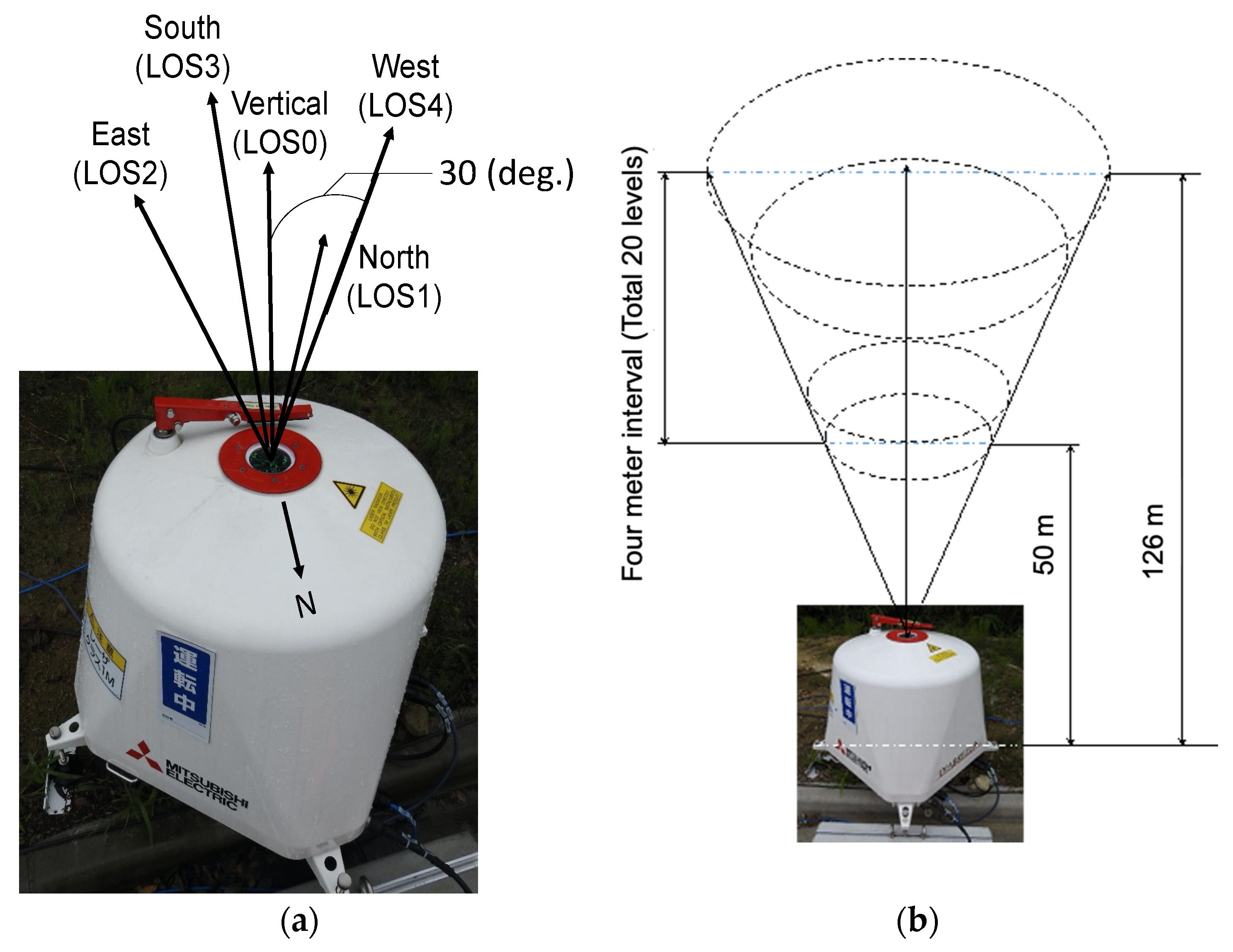
Figure 1. Vertical-profiling LiDAR (DIABREZZA_W, Mitsubishi Electric Corporation) used in this study. (a) Emission directions of laser; (b) measurement heights above ground.
Energies 13 05135 g001
Figure 2. Horizontal (bottom) and side (top) layouts of the LiDAR and both wind turbines.
Energies 13 05135 g002
Figure 3. Cardinal direction profiles of the terrain around the measurement site (Origin: LiDAR installed between two wind turbines on the wind farm. Altitude data obtained from the Geospatial Information Authority of Japan.
Energies 13 05135 g003
Figure 4. LiDAR installed near the meteorological mast position. (a) Outline of measurements; (b) on-site installation configuration.
Energies 13 05135 g004
Figure 5. Cardinal direction profiles of the terrain around the measurement site (Origin: LiDAR installed at the meteorological mast position. Altitude data were obtained from the Geospatial Information Authority of Japan.
Energies 13 05135 g005
Figure 6. Data-acquisition rate of the LiDAR at the mast position over time.
Energies 13 05135 g006
Figure 7. Comparisons of horizontal wind speed measured by the LiDAR, cup anemometer (CUP) and ultrasonic anemometer (sonic) at the mast position. (a) sonic and CUP measurements; (b) LiDAR and CUP measurements. Measurement height (h): h = 56 m (CUP), h = 53 m (sonic), h = 54 m (LiDAR).
Energies 13 05135 g007
Figure 8. Comparison of vertical wind speed measured by the LiDAR and the ultrasonic anemometer (sonic) at the mast position. Measurement height (h): h = 53 m (sonic), h = 54 m (LiDAR).
Energies 13 05135 g008
Figure 9. Comparison of flow inclination angle measured by the LiDAR and the ultrasonic anemometer (sonic) at the mast position. Measurement height (h): h = 53 m (sonic), h = 54 m (LiDAR).
Energies 13 05135 g009
Figure 10. Time history of 10 min average horizontal and vertical wind speed measured by the LiDAR and ultrasonic anemometer (sonic) at the mast position. (a) Horizontal wind speed; (b) vertical wind speed. Measurement height (h): h = 56 m (CUP), h = 53 m (sonic), h = 54 m (LiDAR).
Energies 13 05135 g010
Figure 11. Comparison of flow inclination angle measured by the LiDAR and the ultrasonic anemometer (sonic) at the mast position. Measurement height (h): h = 53 m (sonic), h = 54 m (LiDAR). Horizontal wind speeds below 4 m/s omitted.
Energies 13 05135 g011
Figure 12. Turbulence intensities measured using the LiDAR, the cup anemometer (CUP) and the ultrasonic anemometer (sonic) at the mast position. (a) LiDAR; (b) sonic; (c) CUP; (d) 90% quantiles. Measurement height (h): h = 56 m (CUP), h = 53 m (sonic), h = 54 m (LiDAR).
Energies 13 05135 g012
Figure 13. Data-acquisition rate of the LiDAR at the position between turbines.
Energies 13 05135 g013
Figure 14. Interference of LOS with wind turbine blades every sixteen wind directions. Wind turbines are assumed to face the wind direction (±11.25°).
Energies 13 05135 g014
Figure 15. Comparison between directly measured values and estimated values of instantaneous vertical wind speeds at the position between turbines. (a) Directly measured values from LOS0 and estimated values from LOS1 and LOS3; (b) directly measured values from LOS0 and estimated values from LOS2 and LOS4. Measurement height (h): h = 78 m.
Energies 13 05135 g015
Figure 16. Definition of 12u, 23u, 34u and 41u.
Energies 13 05135 g016
Figure 17. Comparison between 12u and 34u. (a) Position between turbines. Measurement height (h): h = 78 m; (b) mast position. h = 54 m; (c) Position between turbines. h = 54 m; (d) example of result at moderately flat terrain (FREA, h = 54 m).
Energies 13 05135 g017aEnergies 13 05135 g017b
Figure 18. Magnitude of the nonuniformity wind velocity vector plotted against the horizontal wind speed. Measurement height (h): h = 54 m. (a) Position between turbines; (b) mast position; (c) FREA (flat terrain).
Energies 13 05135 g018
Figure 19. Magnitude of the nonuniformity wind velocity vector plotted against the wind direction. Measurement height: h = 54 m. (a) Position between turbines; (b) mast position; (c) FREA (flat terrain).
Energies 13 05135 g019aEnergies 13 05135 g019b
Figure 20. Magnitude of the nonuniformity wind velocity vector for different wind speed ranges plotted against the wind direction.
Energies 13 05135 g020
Figure 21. Turbulence intensity measured at the position between turbines. Measurement height: h = 78 m.
Energies 13 05135 g021
Figure 22. Flow inclination angle for 16 wind directions measured at the position between turbines. Measurement height: h = 78 m.
Energies 13 05135 g022
Figure 23. Turbulence intensity for 16 wind directions measured at the position between turbines.
Energies 13 05135 g023
Figure 24. Turbulence standard deviation ratio σ21 plotted against wind direction (average wind speed: 4–8 m/s; measurement location: position between turbines; measurement height: h = 78 m).
Energies 13 05135 g024
Figure 25. Turbulence standard deviation ratio σ31 plotted against wind direction (average wind speed: 4–8 m/s; measurement location: position between turbines; measurement height: h = 78 m).
Energies 13 05135 g025
Figure 26. Wind direction bin-averaged wind-shear profiles at the position between turbines for different wind directions and different hub-height 10 min average wind speed ranges at the position between turbines. (a) Wind direction: 270° ± 11.25°; (b) wind direction: 292.5° ± 11.25°; (c) wind direction: 315° ± 11.25°; (d) wind direction: 337.5° ± 11.25°.
Energies 13 05135 g026
Figure 27. Wind-veer profiles for different hub-height 10 min average wind speeds between 8 and 12 m/s at the position between turbines. (a) Wind direction: 337.5° ± 11.25°; (b) wind direction: 157.5° ± 11.25°.
Energies 13 05135 g027
Table 1. Main specification of a vertical-profiling LiDAR, DIABREZZA_W, Mitsubishi Electric Corporation.
AspectCharacteristics
Observation range40 m–250 m AGL
Scanning patternDigital switching
Scanning direction0°, 90°, 180°, 270°, Vertical
Range resolutionSelectable from 20 m (selected in this study), 25 m, 30 m
Measurable wind speed range0 m/s–60 m/s
Data update rate2 s or less
Doppler velocity range−30 m/s–+30 m/s
Doppler velocity accuracy error±0.1 m/s or less
Laser wavelength [μm]1.55 μm single frequency
Environmental conditions−20 °C–+ 40 °C, 0–100% RH