Abstract
The Ordos Basin contains abundant coal resources in the Upper Paleozoic strata. They are shallowly buried or exposed in the periphery of the basin, forming recoverable coal mines and coalbed methane resources. For the deeply buried coal seams of the basin, however, due to complex changes and difficult mining, less attention was paid before. In recent years, with the exploitation of tight gas related to coal source rocks, a large amount of drilling and seismic data has been accumulated in the southeastern Ordos Basin, which makes it possible to study the distribution change and factors controlling Upper Paleozoic coal seams. Delineation of deep coal development and distribution is an important basis for coal, coalbed methane and related tight gas resources in the Upper Paleozoic. We use core, logging and seismic data to analyze the coal geophysics, thickness variation, paleotopography and sedimentary facies in the southeastern Ordos Basin. The lower part of the Shanxi Formation (Fm.) and the upper part of the Taiyuan Fm. in the southeastern part of the basin are characterized by low natural gamma ray, low density, high resistivity and high sonic logging values. As the coal velocity is very low and alternates with the high-velocity Taiyuan Fm. and Ordovician limestones, the two sets of coals below and above the Taiyuan limestones form an extremely strong-amplitude reflection in the seismic profile. The two sets of coals are cumulatively 1–10 m thick, averaging 2.4 m, and 4 m is the maximum induvial thickness. The individual coal seams thicker than 2 m cover an area of approximately 2500 km2, and the burial depths of the coal seam range from 2500 to 3000 m. The thick coal seams of the Taiyuan Fm. are mainly distributed proximally in the Ordovician paleokarst depression, while the Ordovician paleokarst depression without incised origin was deposited by distal coeval limestone rocks. There is a complementary relationship between the coal seams and the thickened zone of distributary channel sandstone in the Shanxi Fm.
1. Introduction
The Ordos Basin is a large-scale coal-accumulating basin, and the whole basin mainly contains two sets of coal-bearing rock series: the Upper Paleozoic Carboniferous-Permian and Jurassic series [1,2]. The total amount of coal resources in the basin (less than 2000 m) is approximately 4 trillion tons, and the amount of buried resources within 1000 m is approximately 1 trillion tons [3,4], yielding an important coal production base in China. Coal measure strata are rich in symbiotic and accompanying mineral resources, such as coalbed methane, coal-formed tight gas, germanium, uranium, kaolin and other metal or nonmetallic minerals [5,6,7]. Therefore, the exploration and development of coal resources is significant.
According to the test and analysis of the coalbed in different layers of the Upper Paleozoic strata in the southern Ordos Basin by predecessors, the organic carbon contents in the coalbed of the Shanxi Formation (Fm.) are 40.37–77.11%, with an average value of 54.94%; the contents of chloroform asphalt “A” are 0.0263–0.359%, with an average value of 0.1614%; and the average total hydrocarbon content is 1140.64 × 10−6. The organic carbon contents in the Taiyuan Fm. are 41.1–91.32%, the average is 66.96%, the contents of chloroform asphalt “A” are 0.0193–0.1080%, and the average is 0.0636% [8].
If the coal seam is evaluated as a source rock, the organic matter abundance of coal measures in the southern part of the Upper Paleozoic strata in the Ordos Basin is at a high level, and most of the coal measures have reached the stage of generating dry gas, with Ro values of 1.72–2.28% [9,10]. These values indicate lean coal-lean coal-anthracite, with a high degree of evolution and great gas generation potential [11].
Previous studies on the coal seams of the Shanxi and Taiyuan Fms. in the southern Ordos Basin mostly focused on the geochemical characteristics of the coal seams [12,13,14,15]. Due to the limited data, their vertical and lateral distributions were not very clear.
In recent years, with the exploration of tight gas, an increasing number of wells have revealed Paleozoic coals. We collected data from 101 exploration wells in the southeastern Ordos Basin ranging from northern Fuxian County to southern Xunyi County. In addition, 4 km × 4 km 2D and 3D seismic data are available. All these data are integrated to research the coal thickness, burial depth, sedimentary facies, pleogeomorphy and control factors to provide a reference for the evaluation of coal resources in this area.
2. Geological Setting
The Ordos Basin is located in the western part of the North China platform and has an area of 25 × 104 km2 [16]. The basin is distributed in the N–S direction and is rich in oil, gas, coal, uranium and other important resources. The basin has been divided into six primary structural units, including the Yimeng Uplift, Fault-Fold Belt of the western margin, Tianhuan Syncline, Yishan Slope, Jinxi Fault-Fold Belt and Weibei Uplift [17]. The study area is mainly located in the southeastern part of the Yishan Slope and the northern part of the Weibei Uplift (Figure 1b).
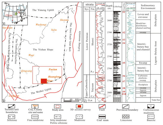
Figure 1.
Regional structural units and location of the study area. (a) Location of the Ordos Basin; (b) Structural units of the Ordos Basin, including the Yimeng uplift, Western thrust belt, Tianhuan depression, Yishan slope, Jinxi flexure belt and Weibei uplift. The study area is located in the southeastern part of the basin. (c) Comprehensive stratigraphic histogram from the upper Carboniferous to the lower Permian strata. O1m represents the Lower Ordovician Majiagou Formation; LLD stands for deep later log; GR stands for natural gamma ray; AC represents acoustic log; DEN means compensated density.
The Ordos Basin experienced four periods of tectonic movements from older to younger, which were the Hercynian, Indosinian, Yan Mountain and Himalayan movement [18]. After the deposition of Ordovician carbonate rocks, the Silurian System-lower Carboniferous strata were missing in the basin under the influence of uplift movement. Regional subsidence occurred in the late Carboniferous, and the basin began to accept Upper Carboniferous–Lower Permian paralic deposits. A set of coal measure strata formed in the lower part of the Shanxi and Taiyuan Fms. On the unconformity at the top of the Ordovician strata, bauxite, tidal flat-lagoon mudstone, channel sandstone, coal and limestone of the Taiyuan Fm. were deposited from lower to upper by filling and leveling. The Taiyuan Fm., which is approximately 20–50 m thick, contains 1–3 layers of open platform limestone interbedded with mudstone, sandstone or coal seams in its upper part. The Shanxi Fm. is composed of local sandstone intercalated with lacustrine mudstone, which is divided into the upper and lower members, each approximately 100 m thick. The lower member contains coal seams and carbonaceous mudstone, and the upper member contains almost no coal (Figure 1c).
According to the data of coal mine outcrops, 10 coal layers are present in the Taiyuan to Shanxi Fms. of the Ordos Basin, which are numbered from top to bottom as #1–10, of which #1–5 are in the Shanxi Fm. and #6–10 are in the Taiyuan Fm. Compared with other coal seams, the #5 and #8 coal seams are the most stable in lateral distribution and larger in thickness. These seams are the two major coal seams in the basin (Figure 2). The thicknesses of other coal seams are generally less than 2 m, their distribution is extremely unstable, and they exist locally.
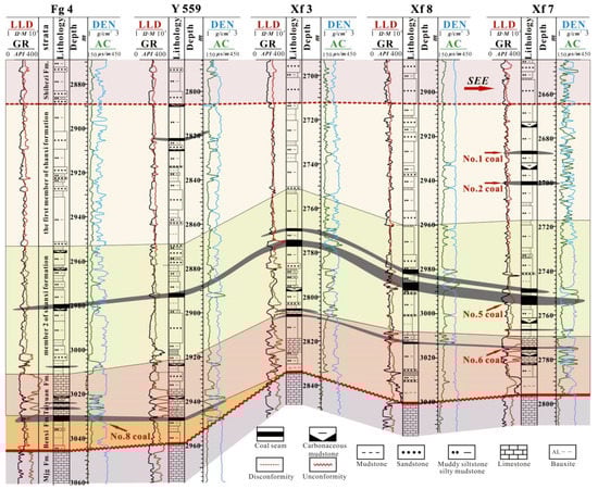
Figure 2.
Profile of wells in the northern part of the study area.
3. Data and Method
The study area is approximately 14,610 km2; 101 exploration wells were drilled into the Lower Paleozoic strata and have well spacings of 3–20 km. They are mainly the tight gas exploration wells of the Yanchang Petroleum Group Corporation, Sinopec (China Petrochemical Corporation) and PetroChina; data from these wells include complete conventional comprehensive logging data, and core data of partial well intervals containing sandstone, coal seams and carbonaceous mudstone. In addition, 2D seismic data and a 3D poststack seismic data volume of approximately 300 km2 is available for the study area. We loaded 16-bit 3D seismic data volumes that have been processed and have high resolution, high signal-to-noise ratios, and high relative amplitude preservation. The seismic vertical sampling interval is 2 ms, the recording lengths are 0–5 s, the dominant frequency of the target layer is approximately 25 Hz, and the black wave peak represents the positive reflection coefficient. Four wells, namely, Xy1, Xy2, Yan626 and Jian1, are present in the 3D seismic survey, all of which were drilled into the Ordovician strata.
On the basis of well logging standardization, we made the cross plot of different lithology by using Gxplorer software, and obtained the threshold of logging identification parameters of sandstone, limestone, coal seam, etc. According to the recognition threshold of different lithologies logging, the Petroworks-Summation module in Landmark was used to measure the thickness of various lithologies in different layers of each well in the study area; the thickness map of coal seams and limestone are constructed by using Doublefox software. In addition, the sedimentary facies map can be drawn according to the ratio of sand stratum.
Previous studies have shown that the Pre-Carboniferous period had been filled up by the end of the Taiyuan period, and there is a mirror-image relationship between the thickness of the Carboniferous strata and the paleogeomorphology of the Pre-Carboniferous period [19]. Therefore, the paleotopography map is roughly replaced by the thickness map of the Taiyuan Fm, so as to analyze the control of paleotopography on sedimentary facies and coal seams.
By making a synthetic seismogram and calibrating seismic horizons, the seismic response characteristics of coal seams are analyzed. 1D forward modeling and seismic attributes are used to analyze the relationship between coal seams, sandstones and the changes in seismic amplitude and to construct the coal seam thickness map from a 3D seismic survey. The coal seam thickness, sedimentary facies, and pleogeomorphy are combined to analyze the factors controlling the coal seam distribution.
4. Geophysical Response Characteristics of Coal Seams
The coal seam in the study area has striking logging response characteristics. According to the data of the core, logging cuttings and lithologic columnar sections of the wells, the response relationship between different lithologies and logs in the target intervals is statistically analyzed, and AC-GR (Acoustic log and Natural gamma ray) crossplots (Figure 3a), and DEN-LLD (Density and Deep lateral resistivity) crossplots (Figure 3b) were constructed for the different lithologies of the Shanxi and Taiyuan Fms.
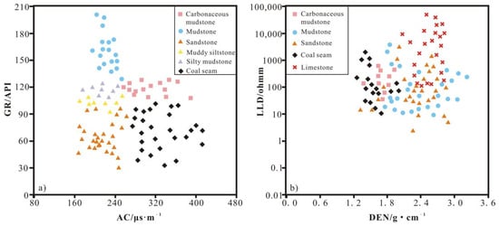
Figure 3.
(a) AC-GR crossplot of different lithologies of the Taiyuan to Shanxi Fms. (b) LLD-DEN crossplot of different lithologies of the Taiyuan to Shanxi Fms.
The crossplots reveal that the AC values of carbonaceous mudstone and coal seams range from 280~420 μs/m, and there is a substantial difference in GR values between coal seams and carbonaceous mudstone. The AC of coal is more than 280 μs/m, and the GR is less than 90 API. For carbonaceous mudstone, GR values are within 90~120 API, and AC values are greater than 280 μs/m. If the GR value > 110 API and AC < 248 μs/m, the lithology is silty sand or calcareous mudstone with relatively high velocity.
The DEN and LLD logging responses of the coal seam are different from those of other rocks. The density of the coal seam is less than 2.0 g/cm3, and the resistivity is more than 10 Ω/m (Figure 3b). Due to rich organic matter, coal seams generally display low wave impedance. According to the AC threshold value of the coal seam, i.e., 280 μs/m, and the DEN value of 2.0 g/cm3, the upper limit of the wave impedance of Upper Paleozoic coal seams is 7143 m/s·g/cm3 in the study area. Therefore, coal seams can be accurately identified and quantitatively interpreted for noncore wells. It should be noted that when the thickness of the coal seam is less than 0.5 m, the logging response might include the contribution of the upper and lower surrounding rocks of the thin coal seam, blurring the boundary between the coal seam logging anomaly and the lithology of the upper and lower surrounding rocks. Therefore, logging’s ability to identify thin coal seams is limited [20,21].
According to the above identification threshold of logs with different lithologies, the thicknesses of various lithologies in different layers of the study area can be calculated by Eexplorer software. By calibrating the different formations of wells Xunyi 1, Xunyi 2 and Jian 1 in the 3D survey on the seismic profiles, it is apparent that the coal seams are approximately calibrated in a half-cycle reflection of extremely strong amplitude with an upper peak and lower valley. The top and bottom surfaces of the Taiyuan Fm. are at the trough and peak positions, respectively. The extremely strong amplitudes of the upper valley and lower peak are due to the large = wave impedance contrast between the low-velocity coal seam and the high-velocity limestone of the Taiyuan Fm. and Ordovician limestone. Moreover, the thicknesses of the Taiyuan Fm. are approximately 50–80 m, roughly corresponding to the half-period of the seismic reflection. Therefore, the seismic reflection of a coal seam is a strong-amplitude marker layer with excellent continuity, which can be compared and traced in large areas of the basin (Figure 4).
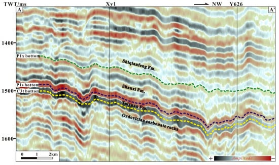
Figure 4.
Seismic section across wells Xy1 and Y626 in the NW direction. See Figure 5a for the location. TWT: two-way travel time.
Through 1D forward modeling analysis, it was found that the thickness of the coal seam is proportional to the amplitude. The greater the thickness of the coal seam is, the stronger the amplitude. If the thickness of the coal seam becomes thinner or pinches out, the amplitude is weakened. Similarly, the thicknesses of limestone and sandstone in the Taiyuan Fm. are also positively correlated with seismic amplitude. The thicker the sandstone or limestone is, the stronger the amplitude. According to the RMS amplitude and poststack inversion wave impedance of the Taiyuan Fm., under the calibration of coal thickness and sandstone content, the coal seam thickness and sandstone content percentage map of the Taiyuan Fm. in the 3D seismic survey can be constructed to provide a reference for regional sedimentary facies analysis (Figure 5). Figure 5a shows that a strong-amplitude area extends from south to north in a “V” shape, corresponding to the area with relatively thick coal seams and sandstones. Through the artificial neural network 3D wave impedance and porosity inversion constrained by well logging, the distribution of the low-wave impedance coal seams and high porosity sandstone in the Taiyuan Fm. can be determined.
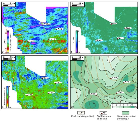
Figure 5.
(a) RMS amplitude map of the Taiyuan Fm. in a 3D seismic survey in the southeastern Ordos Basin; (b) Inversion coal seam time-domain thickness map of the Taiyuan Fm. in a 3D seismic survey; (c) Inversion sandstone content percentage map of the Taiyuan Fm. in a 3D seismic survey; (d) Coal seam isopach map superposed by the sandstone content percentage contours of the Taiyuan Fm. in a 3D seismic survey.
According to Figure 3, the calculated coal seam wave impedance is 7143 m/s g/cm2; the extracted time thickness of wave impedance less than this threshold value can represent the coal seam thickness of the Taiyuan Fm. (Figure 5b). Similarly, the effective porosity of Taiyuan Formation sandstone is between 5–10%, and the time thickness of the extraction porosity inversion volume is more than 6% (it can be converted into sandstone percentage content). Figure 5c shows that the sandstone content of the Taiyuan Formation in the 3D seismic work area as a whole is <10%.
Based on Figure 5b,c, the coal seam isopach map superposed by the sandstone content percentage contour of the Taiyuan Fm can be made (Figure 5d). The results show that the sedimentary background of the 3D seismic survey is a lagoon and swamp with low sandstone content, and mainly consists of mudstone and coal deposit.
5. Coal Seam Distribution Characteristics
The Carboniferous coal seams in the southeastern Ordos Basin are buried at altitudes of approximately −1000 to −2500 km. Calculated from ground altitudes of 700~900 m, the coal burial depths range from 2000 to 3000 m (Figure 6). The top part of the Taiyuan Fm. is a very gentle west-dipping slope overall, with an atypical dip of less than 1°, and the structural contour lines extend in the NNE direction. The stratigraphic correlation section of the Shanxi Taiyuan Fm. indicates that the #5 coal of the Shanxi Fm. and the #8 coal of the Taiyuan Fm. are relatively thick and are the main coal seams in this area.
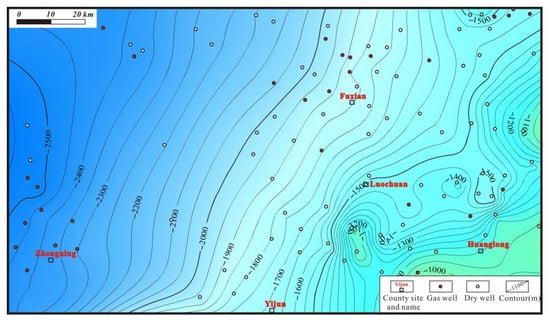
Figure 6.
Structural map of the Taiyuan Fm. in the southeastern Ordos Basin.
Figure 7 shows that the coal seams of the Shanxi Fm. are widely distributed in the study area, with a maximum cumulative thickness of 8 m. The area with a thickness of more than 3 m is roughly distributed in a semicircular arc protruding to the northeast, which is relatively thick in the east and thin in the west. The areas of individual coal seams thicker than 2 m are distributed in 9 locations, which is consistent with the area of thick cumulative coal seams, and the total area is approximately 2460 km2. In the west, the maximum cumulative thickness of the coal seam is less than 4 m.
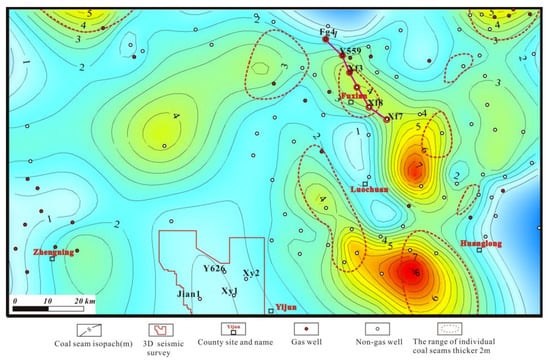
Figure 7.
Coal seam isopach map of the Shannxi Formation on the southeastern margin of the Ordos Basin.
The Taiyuan Fm. has the thickest coal seams, at 6 m thick, which are thick in the southeast and thin in the northwest (Figure 8). The area with an accumulated thickness of more than 4 m is distributed in three semioval shapes in the southern part of the study area. The areas of individual coal seams with thicknesses greater than 2 m are approximately 2023 km2 and are distributed in 9 locations in the southeastern part of the study area, of which 5 locations coincide with areas with thicker cumulative coal seams and 4 locations are located in areas with thinner cumulative coal seams. The coal seams of the Taiyuan Fm. are generally thin in the northwest and thick in the southeast.
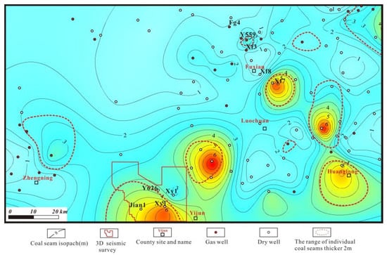
Figure 8.
Coal seam isopach map of the Taiyuan Fm. on the southeastern margin of the Ordos Basin.
A comparison of the coal seam thickness maps of the Taiyuan and Shanxi Fms. reveals that from the Taiyuan to Shanxi Fms., the thicker coal seams are located northward. The tendency of thickness in the south and thinness in the north in terms of the cumulative coal thickness basically exists for both the Taiyuan and Shanxi Fms. (Figure 9).
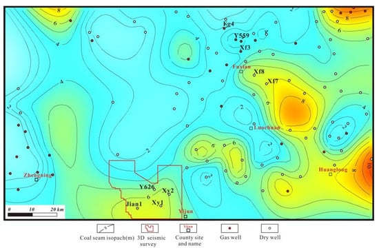
Figure 9.
Total isopach map of coal seams of the Taiyuan and Shanxi Fms. in the southeastern Ordos Basin.
6. Relationship between Coal Seam Development and Paleogeomorphology
The Ordos block was uplifted at the end of the Late Ordovician, forming a 140-million-year unconformity and carbonate karst denudation landforms [22]. In the late Carboniferous, the area resubsided and the Taiyuan Fm. was deposited; then, the seawater intruded from the North Qinling Ocean to the southern part of the basin, forming a broad delta-lagoon and tidal flat swamp depositional system. With the frequent rise and fall of the sea level, mixed coal-bearing deposits of terrigenous clastic and carbonate rocks were formed [23]. In the early Permian, when the orogeny began, the seawater receded, and the sedimentary environment completely changed from sea–land interactions to a continental environment and accepted fluvial, lacustrine and marsh deposits.
Bauxite, sandstone, mudstone and limestone were successively deposited from bottom to top during the Taiyuan period above the unconformity of the top Ordovician system. Swamp coal is mostly developed at the top and bottom of the limestone or in the same horizon as the limestone, indicating the control of the filling and leveling of karst landforms and peneplanarization on carbonate platforms and coal seams. The sandstones abruptly change into mudstone at the top and bottom and display box-shaped natural gamma logs, with scouring surfaces and unidirectionally inclined cross-bedding; the deposits are mainly composed of shallow-water delta distributary channel microfacies and coexist with distributary bay, lagoon mud and swamp coal. The terrigenous clasts come from the southwestern uplift.
The Upper Paleozoic coal seams are distributed close to the Ordovician unconformity. To study the influence of the paleokarst unconformity landform on the sedimentary facies and coal seams, we constructed a pre-upper Paleozoic paleogeological map (Figure 10) and a Taiyuan Fm. sedimentary thickness map (Figure 11). The latter can also be approximately regarded as a paleogeomorphic map of filled karst depressions.
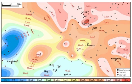
Figure 10.
Pre-Carboniferous paleogeological map of the southeastern Ordos Basin. Є3s is the upper Cambrian Sanshanzi Fm.; O1l is the Lower Ordovician Liangjiashan Fm.; O1m is the Lower Ordovician Majiagou Fm.; O1m1, O1m2 … O1m6 represent the six members of the Majiagou Formation from lower to upper; O1m51, O1m52, … O1m510 represent the submembers of the O1m5 member from upper to lower.
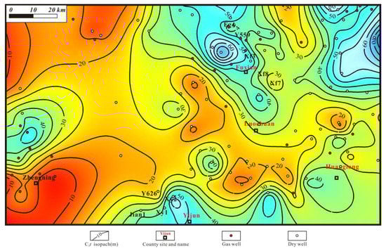
Figure 11.
Stratigraphic isopach map of the Taiyuan Fm. in the southeastern Ordos Basin.
Before Carboniferous deposition, the basin was uplifted, and the Ordovician Majiagou Formation was denuded to different extents, which caused the exposure of different stratigraphy in different areas. Figure 10 shows that from east to west, the denuded strata under the unconformity surface in the study area from northeast to southwest gradually ages, and the amount of denudation gradually increases. Two paleokarst highlands are present in the southwestern part of the study area. The oldest exposed strata are the upper Cambrian Sanshanzi Formation. The two karst highlands extend approximately 30 km and 50 km from Zhengning County in the NNE and ENE directions, respectively. Most other parts of the study area show a northeast-dipping karst slope, and the latest exposed stratum at the northeast edge of the study area is the sixth member of the Lower Ordovician Majiagou Formation (O1m6). The O1m6 member is located in the northeast corner of the study area, the middle of the northern margin and the middle of the western margin, which is equivalent to three paleokarst depressions with the fewest denuded strata. The Middle Ordovician Pingliang Formation remains locally in parts of the northeast-trending karst depressions.
The thickness map of the Taiyuan Fm. basically reflects the relief of the Ordovician paleokarst landform and the accumulation of the provenance supply (Figure 11). In the southwest and northwest corners of the study area, two northeast-extension karst highlands of the Cambrian O1m2 member are exposed. The Taiyuan Fm. is thinner in the highlands, with thicknesses of 5–20 m. The karst depressions that contain thick Taiyuan Fm. appear in four locations, have an irregular shape, are approximately 40 km in length and 20 km in width and have a thickness of 40–60 m. Two of these depression locations appear in the northeast corner and the middle of the northern edge of the study area, which is approximately consistent with the location of the karst depression indicated in Figure 10, where the unconformity surface is underlain by the latest stratum. The other two depression locations are located in the middle of the southern and western edges of the study area, in the exposed area of older strata, and have more denuded strata on the paleogeological map.
A comparison of Figure 10 and Figure 11 shows the characteristics of the northeast-dipping slope in the study area. The ancient southwestern area was high whereas the northeastern area was low, and terrigenous debris likely originated from the southwestern denuded area. Moreover, the latest position of the underlying strata of the unconformity surface in Figure 10 in the northeast corner and the central part of the northern margin of the study area is also consistent with the thickest position of the Taiyuan Fm. in Figure 11, which reflects the existence of the ancient karst depression. However, Figure 11 shows two thickened belts of the Taiyuan Fm. in the middle of the western margin and the middle of the southern margin of the study area, which extend in the NE and near-EW directions, indicating that the underlying Ordovician system in these two thickened zones underwent greater erosion. They are not part of the paleokarst highland but rather the relatively low-lying locations. Therefore, the four thickened areas of the Taiyuan Fm. in Figure 11 have different geological meanings. The two thickened areas of the Taiyuan Fm. near the northeastern margin are in karst depressions with less erosion of underlying strata, and the other two thickened areas of the Taiyuan Fm. near the southwest margin are in the lower incised karst depression where the underlying strata are more denuded; the karst depression belongs to the upstream area near the source.
The upper part of the Taiyuan Fm. generally contains 1–3 layers of open platform micrite limestone and bioclastic limestone with thicknesses of a few meters to more than ten meters. Vertically, coal seams and limestone strata are often close to each other, which indicates that both have the characteristics of peneplain pleogeomorphy, but the lateral relationship between them is not clear. On the isopach map of the cumulative limestone of the Taiyuan Fm. in the research area, limestone is mainly distributed in the karst depression area in the northeastern part of the study area, which is part of the distal clean water lagoon without a delta influence (Figure 12). A comparison of the thickness map of limestone and coal seams in the Taiyuan Fm. reveals that both coal seams and limestone are thickened in karst depression areas, but the coal seams are mainly thickened in the proximal incised karst depression, while the limestone is mainly thickened in the distal clean-water non-incised karstic depression.

Figure 12.
Limestone isopach map of the Taiyuan Fm. in the southeastern Ordos Basin.
7. Relationship between Coal Seam Development and Sedimentary Facies
According to the sandstone content, logging facies and seismic attributes of the Taiyuan and Shanxi Fms. in the study area, the sedimentary facies maps of the lower member of the Taiyuan and Shanxi Fms. are plotted (Figure 13 and Figure 14). The Taiyuan Fm. is a shallow-water delta-lagoon-swamp deposit, and the depositional environment contained four distributary channels flowing from southwest to northeast between distributary channels of the delta plain where swamp coal seams developed. Carbonate rocks were distributed in the distal clear-water environment in front of the delta.
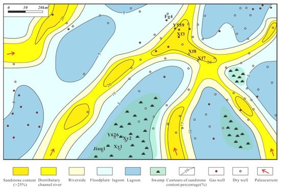
Figure 13.
Sedimentary facies map of the Taiyuan Fm. in the southeastern Ordos Basin.
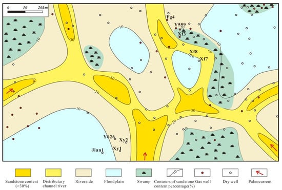
Figure 14.
Sedimentary facies diagram of the Shanxi Fm. in the southeastern Ordos Basin.
The lower Shanxi Fm. is characterized by anastomosing river deposition, with multiple channels developing at the same time, merging and branching with each other in the depositional environment. In the channel, the percentage of the sand in the formation is more than 20%. The sandstone percentages at the bilateral flanks are 10–20% and are less than 10% in peat swamps and floodplains (Figure 14). The clastic material comes from the southern uplift. A complementary relationship seems to occur between the plane distribution of thick coal seams and channel sandstones. The coal seams are thick in areas with less sandstone content and thin in areas with high sandstone content.
Unlike the Taiyuan Fm., the Ordovician karst depressions were filled up when the Shanxi Fm. was deposited, and the coal seam development was no longer controlled by the pleogeomorphy. There is no obvious relationship between the coal seam thickness and the karst pleogeomorphy of the Shanxi Fm., which was completely controlled by the swamps between the rivers.
8. Conclusions
- Two sets of coal seams exist in the Upper Paleozoic in the southeast of Ordos Basin, which are respectively located in the Taiyuan Fm. and the lower Shanxi Fm. The coal thickness of the Taiyuan Fm. is about 0.5–7 m, with an average thickness of about 2.4 m. The cumulative thickness of coal seams of the Shanxi Fm. is about 0.7–8.2 m, with an average thickness of about 2.7 m. The #5 Coals of the second member of the Shanxi Formation and #8 Coals of the Taiyuan Formation have the widest transverse distribution and the greatest thickness; there are 9 areas in the Shanxi Formation where the thickness of the #5 coal seam is more than 2 m (favorable mining areas), which are mainly distributed in the eastern part of the study area and have a total area of about 2460 km2. There are 8 areas in which the thickness of a single seam of #8 coal is more than 2 m in the Taiyuan Formation; these are mainly distributed in the east and south of the work area, and the total area is about 2023 km2.
- The sonic log value of the Upper Paleozoic coal seams in the study area is larger than 280 μs/m, density less than 2.0 g/cm3, GR < 90 API. The coal has extremely strong amplitude seismic reflection and low wave impedance. The greater the thickness of the coal seam, the stronger the amplitude. According to the characteristics of logging response and seismic inversion, the coal seams of 5–8 m in the 3D seismic work area are identified as “V” shaped and distributed in the south of the work area, and the coal seams in the weak amplitude area to the north of the 3D seismic work area are thinned to 2–3 m.
- The coal seam of the Taiyuan Formation is controlled by paleo-geomorphology and sedimentary facies. The coal seam thickens in the near-source incised paleo-karst depressions in the southwest of the study area, but does not develop in the far-source non-incised karst depressions in the northeast area. The development of the coal seam in the lower member of the Shanxi Formation is only controlled by sedimentary facies, and the coal seam is mainly distributed in the lagoon and marsh environment, resulting in sandstone content of less than 10%.
Author Contributions
Conceptualization, R.P.; Investigation, R.P., S.C. and T.J.; Methodology, Y.G.; Project administration, Q.G.; Resources, X.G. and T.J.; Writing—original draft, Y.G., Q.G. and R.P. All authors have read and agreed to the published version of the manuscript.
Funding
This research was supported by Key R & D projects in Shaanxi Province “Study on Paleozoic gas detection method Yanchang exploration area”, Accepted No. S2022-YF-YBGY-0006.
Acknowledgments
The authors thank Sinopec Petroleum Exploration and the Development Research Institute, the Yanchang Exploration Company and the Changqing Oilfield for providing relevant 3D seismic and drilling data.
Conflicts of Interest
The authors declare no conflict of interest.
References
- Li, Y.; Yang, J.; Pan, Z.; Meng, S.; Wang, K.; Niu, X. Unconventional natural gas accumulations in stacked deposits: A discussion of upper paleozoic coal-bearing strata in the east margin of the Ordos basin, China. Acta Geol. Sin. 2019, 93, 111–129. [Google Scholar] [CrossRef]
- Chen, Y.; Ma, D.; Xia, Y.; Guo, C.; Yang, F.; Shao, K. Characteristics of the mud shale reservoirs in coal-bearing strata and resources evaluation in the eastern margin of the Ordos Basin, China. Energy Explor. Exploit. 2020, 38, 372–405. [Google Scholar] [CrossRef]
- Ning, S.Z. Coal resources and tectonic division of Ordos Basin. In Advanced Materials Research; Trans Tech Publications Ltd.: Bäch, Switzerland, 2013; Volume 734, pp. 316–319. [Google Scholar]
- Zeng, X.; Liu, Z.; He, C.; Ma, Q.; Wu, J. Quantifying Surface coal-mining patterns to promote regional sustainability in Ordos, Inner Mongolia. Sustainability 2018, 10, 1135. [Google Scholar] [CrossRef]
- Wang, J.; Xiao, L.; Li, P.; Arbuzov, S.I.; Ding, S. Occurrence mode of selected elements of coal in the Ordos Basin. Energy Explor. Exploit. 2019, 37, 1680–1693. [Google Scholar] [CrossRef]
- Feng, X.; Zhang, N.; Chen, X.; Gong, L.; Lv, C.; Guo, Y. Exploitation contradictions concerning multi-energy resources among coal, gas, oil, and uranium: A case study in the Ordos Basin (Western North China Craton and Southern Side of Yinshan Mountains). Energies 2016, 9, 119. [Google Scholar] [CrossRef]
- Jiao, Y.; Wu, L.; Rong, H.; Peng, Y.; Miao, A.; Wang, X. The relationship between Jurassic coal measures and sandstone-type uranium deposits in the northeastern Ordos Basin, China. Acta Geol. Sin. 2016, 90, 2117–2132. [Google Scholar] [CrossRef]
- Weiqiang, H.; Jingzhou, Z.; Jun, L. Characteristics of source rocks and its controls on the formation and distribution of gas from Upper Paleozoic in Southwest Ordos Basin. Nat. Gas Geosci. 2015, 26, 1068–1075. [Google Scholar]
- Guo, W.; Shen, W.; Zhou, S.; Xue, H.; Liu, D.; Wang, N. Shale favorable area optimization in coal-bearing series: A case study from the Shanxi Formation in Northern Ordos Basin, China. Energy Explor. Exploit. 2018, 36, 1295–1309. [Google Scholar] [CrossRef]
- Dai, S.; Ren, D.; Chou, C.L.; Li, S.; Jiang, Y. Mineralogy and geochemistry of the no. 6 coal (Pennsylvanian) in the Junger Coalfield, Ordos Basin, China. Int. J. Coal Geol. 2006, 66, 253–270. [Google Scholar] [CrossRef]
- Fu, J.; Wei, X.; Luo, S.; Zhifeng, Z.; Hu, Z.; Baoxian, L.; Junxiang, N. Discovery and geological knowledge of the large deep coal-formed Qingyang Gas Field, Ordos Basin, NW China. Pet. Explor. Dev. 2019, 46, 1111–1126. [Google Scholar] [CrossRef]
- Li, G. Coal reservoir characteristics and their controlling factors in the eastern Ordos basin in China. Int. J. Min. Sci. Technol. 2016, 26, 1051–1058. [Google Scholar] [CrossRef]
- Li, Y.; Tang, D.; Wu, P.; Niu, X.; Wang, K.; Qiao, P.; Wang, Z. Continuous unconventional natural gas accumulations of Carboniferous-Permian coal-bearing strata in the Linxing area, northeastern Ordos basin, China. J. Nat. Gas Sci. Eng. 2016, 36, 314–327. [Google Scholar] [CrossRef]
- Qi, Y.; Ju, Y.; Tan, J.; Bowen, L.; Cai, C.; Yu, K.; Zhang, W. Organic matter provenance and depositional environment of marine-to-continental mudstones and coals in eastern Ordos Basin, China—Evidence from molecular geochemistry and petrology. Int. J. Coal Geol. 2020, 217, 103345. [Google Scholar] [CrossRef]
- Sun, S.; Chen, A.; Chen, H.; Hou, M.; Yang, S.; Xu, S.; Ogg, J.G. Early Permian chemical weathering indices and paleoclimate transition linked to the end of the coal-forming episode, Ordos Basin, North China Craton. Palaeogeogr. Palaeoclimatol. Palaeoecol. 2022, 585, 110743. [Google Scholar] [CrossRef]
- Liu, J.; Xie, S.; Liu, K. Evolution superposition and petroliferous property of Ordos Basin—Prototype analysis of a large basin within the Chinese Mainland plate. Oil Gas Geol. 1986, 5, 356–367. [Google Scholar]
- Jianmin, W.; Jiayuan, W. Low-amplitude structures and oil-gas enrichment on the Yishaan Slope, Ordos Basin. Pet. Explor. Dev. 2013, 40, 52–60. [Google Scholar]
- Liu, C.; Zhao, H.; Sun, Y. Tectonic background of Ordos Basin and its controlling role for basin evolution and energy mineral deposits. Energy Explor. Exploit. 2009, 27, 15–27. [Google Scholar] [CrossRef]
- Xiao, D.; Tan, X.; Fan, L.; Zhang, D.; Nie, W.; Niu, T.; Cao, J. Reconstructing large-scale karst paleogeomorphology at the top of the Ordovician in the Ordos Basin, China: Control on natural gas accumulation and paleogeographic implications. Energy Sci. Eng. 2019, 7, 3234–3254. [Google Scholar] [CrossRef]
- Esterle, J.S.; Roslin, A. Electrofacies analysis using high-resolution wireline geophysical data as a proxy for inertinite-rich coal distribution in Late Permian Coal Seams, Bowen Basin. Int. J. Coal Geol. 2015, 152, 10–18. [Google Scholar]
- Knight, J.L.; Shevlin, B.J.; Edgar, D.C.; Dolan, P. Coal thickness distributions on the UK continental shelf. Geol. Soc. Lond. Spec. Publ. 1996, 109, 43–57. [Google Scholar] [CrossRef]
- Jiang, Z.; Xu, J.; Wang, G. The discovery and significance of a sedimentary hiatus within the Carboniferous Taiyuan Formation, northeastern Ordos Basin, China. AAPG Bull. 2012, 96, 1173–1195. [Google Scholar] [CrossRef][Green Version]
- Du, W.; Jiang, Z.; Li, Q.; Zhang, Y. Sedimentary characterization of the Upper Paleozoic coal-bearing tight sand strata, Daniudi Gas Field, Ordos Basin, China. J. Earth Sci. 2016, 27, 823–834. [Google Scholar] [CrossRef]


Publisher’s Note: MDPI stays neutral with regard to jurisdictional claims in published maps and institutional affiliations. |
© 2022 by the authors. Licensee MDPI, Basel, Switzerland. This article is an open access article distributed under the terms and conditions of the Creative Commons Attribution (CC BY) license (https://creativecommons.org/licenses/by/4.0/).