Abstract
Ordovician carbonate reservoirs in the Shunbei area of the Tarim Basin are characterized by large burial depth, small vertical fault displacement of the strike-slip fault zone, small karst development scale, strong reservoir heterogeneity, complex and diverse seismic reflection types, which lead to unclear seismic response characteristics of fault zone and reservoir, and further restrict the fine description of ultra-deep (>7300 m) fault controlled reservoirs. On the basis of high-precision 3D seismic data analysis, combined with drilling, logging, and comprehensive geological interpretation data in the Shunbei area, seismic geological models of different types of reservoirs and fault zones are established. The changes in seismic response characteristics of fault zones and reservoirs are simulated and analyzed by changing reservoir size, scale, fault and fracture cavity combination modes, as well as other factors. On this basis, two seismic identification models of fault-controlled reservoirs in the Shunbei area are summarized and established. The seismic identification mode of seismic reflection marker wave of fault-controlled reservoir is mainly “fault seismic response characteristics & weak reflection” and red trough anomaly under T74. The internal seismic identification modes are mainly “fault seismic response characteristics & random reflection”, “fault seismic response characteristics & beading”, “fault seismic response characteristics & linear weak reflection”, and “fault seismic response characteristics & random reflection”. Among them, except for “fault seismic response characteristics & random reflection”, the coincidence rate of reservoir prediction of other three types of seismic response characteristics is more than 70%. The coincidence rate of the other three types of seismic response characteristics of a reservoir is more than 70%. The research results provide a reference for the prediction and description of ultra-deep carbonate fault-controlled reservoirs.
1. Introduction
The lower Paleozoic Ordovician carbonate rocks in the large superimposed basin of Tarim are the main exploration fields in the platform basin area. Around the two paleo-uplifts of Shaya and Katake (Figure 1), Tahe oilfield, Tazhong oilfield and other oil and gas fields dominated by karst fracture caves have been successively discovered [1,2,3,4,5,6,7]. However, the Shuntuoguole low uplift, located in the low part of the structure between the paleo-uplifts, has been regarded as a “restricted area” for exploration for a long time due to factors such as large buried depth and unclear reservoir forming conditions [8,9,10]. The Shunbei area under study is located in the middle and north of the Shuntuoguole low uplift of the Tarim Basin. The regional structure is located in the structural saddle slope area sandwiched between the Manjiaer depression and Awati depression, and a large number of studies show that the oil and gas accumulation conditions are superior [11,12,13,14,15,16,17,18,19,20,21,22].
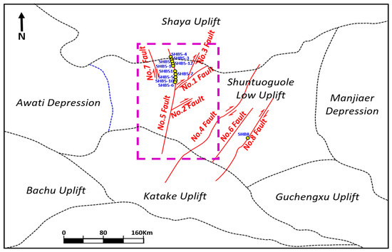
Figure 1.
The location diagrammatic sketch of the study area (marked by pink rectangles) and the main strike-slip fault zones, as well as nearby major tectonic units in the northern Tarim Basin. Around the Shaya uplift is the Tahe oil field, the Katake uplift is the Tazhong oil field, and the area between them is the Shunbei oil field.
Years of exploration practice have proved that the Ordovician carbonate rocks in Shunbei area have the geological background of reservoir development. The fault zone plays a key role in controlling reservoir development and oil and gas accumulation [23,24,25,26,27,28,29,30]. The reservoir space type is mainly a fault-controlled karst fracture cave. Among them, Shunbei No. 1 zone, No. 5 zone, No. 7 zone, No. 4 zone (Figure 1) and other fault zones have made oil and gas discoveries, and built a million-ton oil and gas field [31,32]. The Shunbei area has broad exploration and development prospects. However, the study area is completely covered by desert, with a large reservoir burial depth (>7300 m), small strike-slip fault distance, strong reservoir heterogeneity, weak ultra-deep seismic acquisition reflection signal, weak energy, low signal-to-noise ratio, low reservoir imaging accuracy, and unclear reservoir seismic reflection characteristics. It brings many challenges to the understanding of seismic response characteristics and prediction of fault-controlled reservoirs in the Shunbei area [33,34], affecting the exploration and development process of this area.
In the early stage, research was carried out in Tarim Basin on seismic response characteristics and the prediction of karst fracture cave reservoirs buried 5000–6000 m. It believed that the seismic identification model of carbonate karst fracture cave reservoirs with strong dissolution mainly displayed strong “string of beads” seismic reflection characteristics. The larger the “string of beads” amplitude energy, the better the physical properties of the reservoir. RMS amplitude and the amplitude rate of change attribute are effective technical means to predict the reservoir. Based on these research results and technologies, Tahe Oilfield has been discovered [3,35,36,37,38]. For the Shunbei area, the formation of a fault-controlled reservoir is controlled by many factors. Fault cavities, caves, fractures, and vugs can all be used as good oil and gas reservoir spaces. Multiple reservoir space types are stacked together, and seismic response characteristics are diverse and complex. It is difficult to establish an effective seismic identification model for reservoirs, which further restricts the characterization of fault-controlled reservoirs.
In view of the unclear seismic reflection characteristics of fault-controlled reservoirs and the difficulty of reservoir prediction, this article summarizes the geological characteristics and development mode of fault-controlled fracture cave reservoirs from drilling wells. We study a set of technical processes for establishing the seismic identification mode of ultra-deep fault-controlled reservoirs in the Shunbei area, use the non-uniform medium wave equation and carry out a numerical simulation based on the staggered grid finite difference scheme [39,40,41]. It provides a basis for the interpretation and evaluation of different levels of strike-slip faults and the effective prediction.
In this article, we first investigated the previous research results on the geological characteristics of fault-controlled reservoirs, and combined with the drilling reservoirs seismic calibration in Shunbei area, we clarified the geological characteristics and development mode of ultra-deep fault-controlled reservoirs. We then establish a series of theoretical reservoir models of cave type, vug type, fracture type, equivalent fault-controlled fracture cave type and drilling fault-controlled reservoir models, and the wave equation forward simulation analysis is carried out with parameters that are close to the 3D seismic acquisition. At last, on the forward modeling results, combined with the statistical of seismic facies calibration of the drilling reservoir, we establish a fault-controlled reservoir seismic identification model most consistent with geological understanding in the Shunbei area. Figure 2 is the research work flow chart.
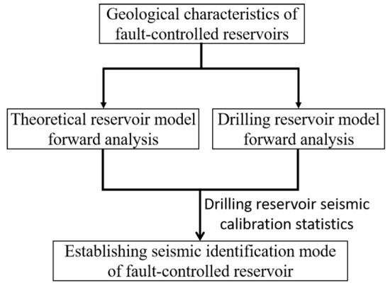
Figure 2.
A chart of the research work flow.
2. Development Background and Characteristics of Fault-Controlled Reservoir
The Ordovician carbonate strata in the Shunbei area of Tarim Basin vary in thickness from 500 m to 2900 m [18]. They are generally divided into lower Ordovician (the top of the layer system corresponds to T78 seismic reflection interface, which is the top of Penglaiba Formation), middle Ordovician (Yijianfang Formation, which corresponds to T74 seismic reflection interface; the top of Yingshan Formation corresponds to T75 seismic reflection interface) and upper Ordovician (Qiaerbake, Lianglitage and Sangtamu formations). Except that Sangtamu Formation is a clastic rock deposition, other groups are carbonate sedimentary formations (Figure 3).
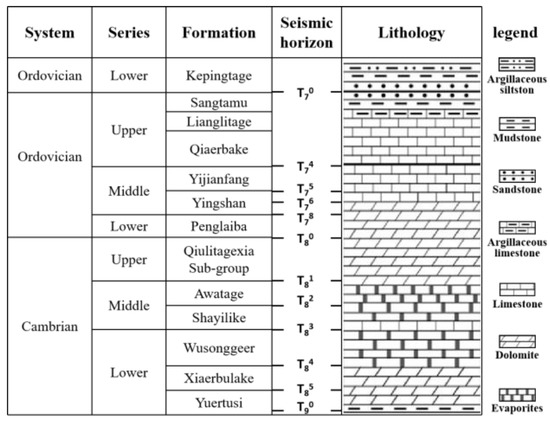
Figure 3.
A chart of the Shunbei Cambrian-Ordovician stratigraphy, the seismic horizon, and the lithology.
Fault-controlled reservoirs in the Shunbei area are carbonate fracture cave reservoirs developed along the fault zone, which are formed by many factors such as “fault zone, atmospheric fresh water, and deep heat flow”. After being subjected to multi-stage tectonic compression, carbonate rocks develop a certain scale of fracture zone along the deep fault zone [42,43]. After multi-stage karst water infiltration along the fault or local hydrothermal upwelling, the small faults and fractures in the fault zone are corroded and transformed to form columnar corrosion pores and cave reservoirs [44]. This kind of carbonate reservoir is obviously controlled by the strike-slip fault zone, and the scale of the fault zone is one of the most important factors affecting the reservoir scale [2,30,45].
The large strike-slip fault zones are easy to be interpreted and discovered in 3D seismic data. For finding oil and gas with industrial value, we need to find large-scale reservoir targets, which requires us to know the response characteristics of the reservoir controlled by the strike-slip fault zone in seismic data. We selected the drilling data in the Shunbei and adjacent areas for research, hoping to find the geophysical characteristics of the reservoir.
We performed fine seismic calibration on the reservoirs of 41 wells, and counted the seismic response characteristics of the reservoirs. The results show that the fault position and amplitude abnormal reflection are the characteristics of the reservoirs that can be drilled with high probability.
The thick mudstone above the top surface of the carbonate rock formation of the Yijianfang Formation and the limestone in the upper Yijianfang Formation form a "contin-uous strong reflection" seismic response due to the large impedance difference, which is called the T74 wave group. The inner wave formation below T74 interface is “a continuous weak reflection” formed by the carbonate sedimentary surface or lithologic interface. The seismic response characteristics of these two reflection wave groups to faluts, caves, fractures and vugs are inconsistent, so it is necessary to separately statistically analyze the reservoir seismic response characteristics of T74 wave group and interior wave group.
Five wells in the north section of the Shunbei No. 5 fault zone (Figure 1) drilled to the upper part of Yijianfang Formation (T74 seismic horizon), and seven fault planes were drilled, of which six had venting or leakage, accounting for 85.7%. These sections are characterized by fracture zone in the Yijianfang Formation, high-quality reservoir connectivity, and high oil and gas production, which are characterized by fault dislocation and weak amplitude of the seismic wave group (Figure 4).
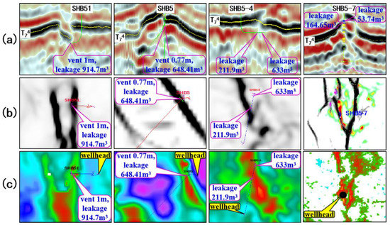
Figure 4.
A fault profile and plane characteristics of Yijianfang Formation marker wave group. (a) seismic profile. The pink box indicates the location and data of drilling venting and leakage; (b) weak coherence stratum slice along T74 seismic horizon. The color represents the coherence value. The darker the color is, the weaker it is. It can predict the plane position of fault; (c) weak amplitude stratum slice along T74 seismic horizon. The color represents the amplitude attribute value. The redder, the weaker, and the plane position of the fault is predicted.
For the reservoir characteristics of the inner wave formation, the surrounding rock outside the fault zone reflects continuously along the layer, and the overall energy is mainly weak. The inner reservoir is discontinuous, which is characterized by various and complex types such as section point, line or sheet, plane point, polygon, and strip. Generally, according to the statistics and induction of drilling wells, the seismic reflection characteristics of the inner reservoir can be roughly divided into four categories: (i) standard beading, (ii) non-standard beading, (iii) linear weak reflection, and (iv) random reflection (Figure 5). The drilling fluid venting leakage rate varies greatly among different seismic response types, ranging from 50% to 80%. This is not only related to the insufficient statistical sample points, but also to the highly heterogeneous reservoir, which is difficult to classify and depict. From the effect of chaotic reflection drilling in the four categories, clutter is the response of fracture network reservoirs. Fractured reservoirs with low average velocity can form strong reflection, but the reservoir connectivity is poor, so acid fracturing is often required for production.
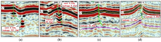
Figure 5.
Different types of seismic reflection characteristics of the inner reservoir. The black box indicates the location and data of drilling venting and leakage in the seismic profile. (a) Standard beads: the ratio of major axis to minor axis on the plane and section is close to 1, nearly circular; (b) Non-standard beads: irregular amplitude abnormal reflection with non-circular shape; (c) Linear weak reflection; (d) Random reflection.
The seismic response characteristics of the reservoir obtained based on the drilling data statistics in Figure 4 and Figure 5 indicate the reservoir sections directly drilled around the drilling, without considering the influencing factors of the carbonate reservoir genesis and the difference of the reservoir space. Ordovician carbonate fault-controlled reservoirs in the Shunbei area are controlled by multiple factors such as fault zone and karst, and the level of fault zone, and fracture cave dissolution are different. In addition, the combination of the fault zone and fracture cave is complex and diverse, resulting in extremely complex seismic response characteristics of the reservoir, which needs to be studied through forward modeling [46,47,48]. We establish the corresponding relationship between fault zone, fracture cavity body, and seismic response characteristics, guide fault zone evaluation and reservoir prediction, and provide support for optimizing favorable targets.
3. Methods—Theoretical Model and Analysis of Seismic Response Characteristics
The distribution of deep Ordovician reservoirs in the Shunbei area is closely related to the main strike-slip faults and secondary (concealed) faults associated with the main fault activities. The internal structure of fault-controlled is very complex, including caves, vugs, fractures and their combinations. The reflection characteristics of reservoirs on seismic profiles are mostly the comprehensive response of several reservoir types [10]. In order to clearly understand the seismic response characteristics of various reservoirs, combined with drilling, logging and seismic interpretation data, the theoretical models of various reservoirs are established according to the Ordovician stratigraphic structure and petrophysical parameters of each formation in the Shunbei area. The petrophysical parameters of the formation are shown in Table 1.

Table 1.
Petrophysical parameters of Ordovician strata and the reservoir in the Shunbei area.
In the Ordovician carbonate strata of Tarim basin, caves are cavities formed by rock fragmentation caused by fault activities or karst caves formed by supergene karstification. They have good physical properties and are the main type of carbonate reservoirs [49,50,51]. According to the stratigraphic structure and petrophysical parameters of the Shunbei area, a group of geological models of caves are designed. It is considered that the caves are not completely fluid filling and may contain some mud. Therefore, the parameters of the cave are designed as follows: velocity is 3000 m/s, density is 2.2 g/cm3, height is 50 m, and the width increases from 10 m to 400 m, as shown in Figure 6a. In order to more realistically simulate the seismic response characteristics of the medium to guide the interpretation of actual seismic data. The parameter setting of forward simulation refers to the actual field 3D seismic acquisition system, in which the shot spacing is 50 m, the track spacing is 50 m, the arrangement length is 3200 m, the minimum shot offset is 50 m, and the dominant frequency of Ricker wavelet is 22 Hz. The forward simulation analysis is carried out by using the numerical simulation technology of acoustic equation based on the staggered grid finite difference scheme [52]. The forward simulation section of cave type reservoir is shown in Figure 6b, which is the projection of cave shape onto the seismic section. According to the analysis from the Figure 6, the seismic response characteristics of the cave are strong beaded reflection, the reflected energy is related to the horizontal size of the cave, and the spatial size of the cave is much smaller than the inclusion of beaded reflection.
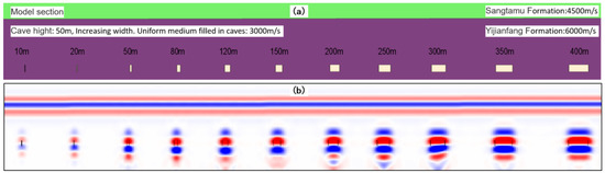
Figure 6.
A geological model and forward modeling section of the cave reservoir. (a) cave reservoir geologic model and its parameters; (b) the profile of cave model superimposed on forward simulation results.
The vuggy reservoir is one of the main reservoir types in the Shunbei area, and the distribution of pores in fault-controlled reservoirs also accounts for a large proportion. Based on the previous research results, the theoretical model of the vuggy reservoir is established, as shown in Figure 7a. Considering the requirements of an analog amplifier, software and hardware, the vugs are designed as an aggregate. The single vug size is less than 1 m, the space is unevenly distributed, the hole velocity is 4500 m/s, the density is 2.42 g/cm3, and the background stratum is limestone. The forward simulation parameters are the same as the cave model, and the mesh size is 0.5 m. The forward modeling section of a vuggy type reservoir is shown in Figure 7b, which is the vug geological model superimposed on the forward seismic section, and the vugs are randomly distributed within 100 m. From the analysis of a forward profile, the vuggy reservoir is characterized by weak chaotic reflection.
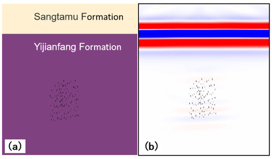
Figure 7.
A geological model and forward modeling section of a vuggy reservoir. The black dots are vugs and are designed as an aggregate. The single vug size is less than 1 m. (a) the vuggy reservoir geologic model; (b) the profile of vugs model superimposed on forward simulation results.
The strong activity of strike-slip faults is also accompanied by the generation of fractures, especially the fractures around the main faults which are relatively developed. It is also a type of reservoir in the Shunbei area and is likely to be an oil and gas reservoir space. The design of the fracture model is also considered as an aggregate. The fracture width is less than 1 m and the height is 200 m, as shown in Figure 8a. The fracture density within 400 m of the fracture development area is unevenly distributed, the fracture velocity is 5100 m/s, the density is 2.51 g/cm3, and the background stratum is limestone. The forward simulation parameters are the same as the cave model, and the mesh size is 0.5 m. The forward modeling section of the fractured reservoir is shown in Figure 8b. The geological model of the fractured reservoir is superimposed on the forward seismic section. The fractures are vertically distributed within 400 m, and the fractures on the forward section are also a weak random reflection.
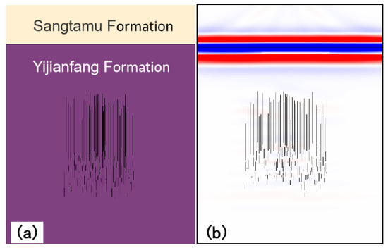
Figure 8.
A geological model and forward modeling section of the fractured reservoir. The black lines are fractures and are designed as an aggregate. The single fracture width is less than 1 m and the height is 200 m. (a) the fracture geologic model; (b) the profile of fracture model superimposed on forward simulation results.
In actual formation, the probability of single reservoir type is small, and most of them are complex combinations of several reservoir types. Fault-controlled reservoirs in the Shunbei area are also the combination of several reservoirs, which are characterized by different spatial structures, variable combination types and different sizes. Therefore, the fault-controlled fracture cave reservoir is designed as shown in Figure 9a. The stratum is from Sangtamu Formation to Penglaiba Formation. The width of two fault zones is 20 m. Caves, vugs, and fractures are distributed around the fault zone. The size of caves is 10~20 m, the size of holes is less than 1 m, and the width of fractures is less than 1 m. The reservoirs are randomly combined in disorder. The petrophysical parameters are shown in Table 1. The forward simulation parameters are the same as the cave model, and the mesh size is 0.5 m. The forward modeling section of the fault-controlled fracture cave reservoir is shown in Figure 9b, which is the superposition of geological model and forward modeling section. From the analysis of the figure, the reflection anomaly is the comprehensive response characteristic of the reservoir. The cave reservoir is a strong beaded anomaly reflection, and the vug and fracture reservoir are a medium weak chaotic anomaly reflection.
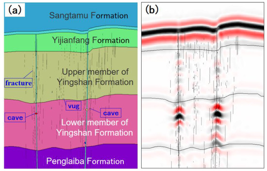
Figure 9.
A geological model and forward modeling section of the fault-controlled fracture cave reservoir. (a) fault-controlled fracture cave reservoir geologic model; (b) the profile of fault-controlled fracture cave model superimposed on forward simulation results.
4. Results
4.1. Fault-Controlled Fracture Cave Reservoir Model and Seismic Response Analysis of Yijianfang Formation
We further study the relationship between the fault-controlled fracture cave reservoir of Yijianfang Formation and T74 reflected wave group, mainly considering the influence of distance between the reservoir top and T74. According to the analysis of drilling, logging and oil and gas production testing data, as well as seismic and geological knowledge in this area, a fault-controlled fracture cavity reservoir model of Yijianfang Formation as shown in Figure 10 is established. The thickness and velocity of each layer are consistent with the theoretical model (Table 1). We design 7 fault-controlled fracture cave reservoirs at different distances from the top surface to the top of Yijianfang Formation. Through forward modeling analysis, a comparative study on seismic response wave field characteristics was generated by different positions of fault-controlled fracture caverns.
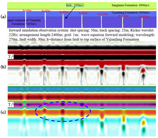
Figure 10.
Seismic response characteristics at different distances between the top surface of the fault controlled fracture cavernous reservoir and the top surface of the Yijianfang Formation. (a) geologic model, different colors represent different strata; (b) forward modeling seismic imaging section; (c) color display of forward modeling seismic imaging section.
In order to facilitate the research and reduce the interference of multiple factors, the cavity body of fault-control fracture is equivalent to a velocity homogeneous body. The width of the 7 fault-control reservoirs is 30 m, and the filling equivalent velocity is 4300 m/s. The distances are 0 m, 30 m, 60 m, 90 m, 120 m, 150 m, and 180 m, respectively. The wave equation of inhomogeneous medium is used for forward modeling calculation, and the simulation parameters are the observation system close to the 3D seismic data acquisition in the Shunbei area. The parameters are a shot spacing of 50 m, a track spacing of 25 m, an arrangement length of 2400 m, and a calculation grid of 1 m. The seismic excitation wavelet is the Ricker wavelet with the dominant frequency of 22 Hz. Shot records acquired by forward simulation are processed by migration imaging method.
The forward modeling results are shown in Figure 10. When the top surface of the reservoir coincides with the top surface of Yijianfang Formation or is less than 30 m, the T74 seismic horizon and the seismic trough (red) below it all show the characteristics of weak seismic reflection amplitude. When the top surface of the reservoir is 30~150 m away from the top surface of the Yijianfang Formation, the reservoir is mainly characterized by an abnormal amplitude of seismic trough (red) below the T74 seismic horizon. As the top surface of the reservoir is farther away from that of Yijianfang Formation, the reservoir shape changes from convex to concave in the seismic wave trough (red) below the T74 horizon, and the amplitude energy becomes stronger. When the top surface of the reservoir is very far from the top surface of the Yijianfang Formation and enters the Yingshan Formation, it mainly displays the “string of beads” reflection feature.
4.2. Model Establishment and Seismic Response Characteristics Analysis of Fault-Controlled Fracture Cave Reservoir in Ordovician of Shunbei Area, Tarim Basin
According to the structural style difference of the strike-slip fault zone and the geological mode of the fault-controlled fracture cavern reservoir in the Shunbei area, different fault styles and fracture cavern combination models are designed. Based on seismic, drilling, and geological data, the width, filling style, and filling velocity of the fault-controlled fracture cave are reasonably designed. Additionally, a forward model, which is consistent with the actual drilling reservoir development, is obtained for research.
A total of 10 groups of seismic forward models are designed this time, and the observation system is designed with reference to seismic acquisition parameters. The parameters are described as follows: track spacing is 50 m, shot spacing is 50 m, and the arrangement length is 6000 m. Wave equation is used to simulate the field shooting acquisition, the calculation grid is 2 m, the middle shooting is conducted, and the dominant frequency is 22 Hz wavelet.
The forward model A (Figure 11) is designed as a compressional strike-slip fault with reference to the seismic profile passing through well SHB5-l and perpendicular to the fault zone. The fault distance of the main fault is 70 m in the Yingshan Formation. Multiple branch small faults, fractures, and vugs are designed near the fault zone from the Yijianfang Formation to the Penglaiba Formation, and multiple caves with a width of 10–30 m are designed near the fault zone. Through field outcrop geological research, fault interpretation and prediction of seismic profile, horizontal drilling speed change and other methods in the Tarim Basin, the fault zone width is determined to be 30–40 m, and the fracture width is determined to be 3–4 m by reference to seismic resolution, grid size used to calculate forward model, equivalent scale of the fracture zone and other factors. Fractures are randomly distributed in the reservoir development zone. The equivalent velocities corresponding to different formations and reservoirs are obtained according to the drilling core and logging statistics, and that corresponding to caves and fault zones are 4000 m/s and 5500~6200 m/s.
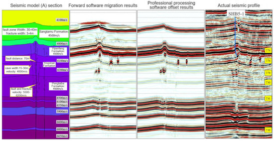
Figure 11.
A comparison between the migration result of the forward model A and seismic profile of actual drilling.
The forward modeling results show that the cave reservoirs interior of Ordovician are mainly characterized by strong amplitude “string of beads” reflection, and the strike-slip fault in the Yingshan Formation has obvious seismic event dislocation due to large vertical fault displacement. It is mainly characterized by “linear weak reflection” in the area where faults and fractures are densely developed, and it is also characterized by “chaotic facies” reflection in the area where pores are developed. The forward modeling results are in good agreement with the actual seismic profile.
The forward model B (Figure 12) is designed as a downward strike-slip fault with reference to the seismic profile passing through well SHB5-5 and perpendicular to the fault zone. The two main strike-slip fault zones are approximately parallel. A number of branch minor faults and fractures are designed near the fault zone from Yijianfang Formation to Penglaiba Formation, and a cave with a width of about 60 m is designed. The determination standard of the fault zone and fracture width is the same as that of model A, but slightly different according to different drilling characteristics.
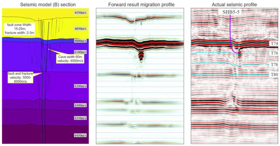
Figure 12.
A comparison between migration results of forward model B and seismic profile of actual drilling.
The forward modeling results are in good agreement with the actual seismic profile. The cave reservoirs interior of Ordovician are mainly characterized by strong amplitude “string of beads” reflection, and the fault fracture development area is mainly characterized by a “linear weak reflection”.
Model C (Figure 13) is designed as a translational strike-slip fault with reference to the seismic profile passing through well SHB5-12 and perpendicular to the fault zone. Several fractures, vugs development zones and three caves with a width of 60–80 m are designed near the fault zone. The determination standard of the fault zone and fracture width is the same as that of model A, but is slightly different according to different drilling characteristics.
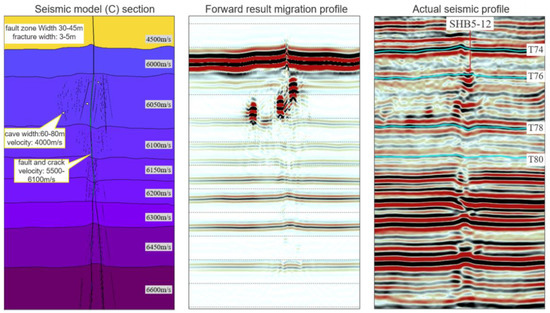
Figure 13.
A comparison between migration results of forward model C and seismic profile of actual drilling.
The forward modeling results are in good agreement with the actual seismic profile. The Ordovician inner cave reservoir is mainly characterized by “string beads” reflection with strong amplitude, and the fault fracture development area is mainly characterized by “linear weak reflection”.
5. Discussion
The discovery of fault-controlled fracture cave reservoirs in the Shunbei area has confirmed the huge exploration potential of the large strike-slip fault zone of ultra-deep carbonate formations in the Tarim Basin. The poor quality of seismic data caused by strong reservoir heterogeneity, deep burial depth, surface desert coverage and other factors, as well as insufficient sample points (less than 50 wells can be used to carry out statistical work), make the seismic identification mode of the fault-control fracture cave reservoir unclear and the reservoir difficult to identify. In this paper, based on the statistical results of reservoir seismic characteristics of some wells, and using the forward simulation method to synthesize the theoretical reservoir model and different types of typical through well reservoir models to make up for the lack of drilling can not drill enough seismic facies characteristics, we can finally obtain the seismic identification mode of fault-controlled reservoirs in ultra-deep carbonate, and thus provide a basis for the interpretation and effective characterization of fault-controlled reservoirs.
The seismic response characteristics of the reservoir obtained from the statistics of 41 wells are compared with the results obtained from the forward modeling analysis of the model. The relationship between the strike-slip fault zone, fracture cavity body and the seismic response characteristics is found, and the seismic identification mode of the ultra-deep fault-controlled reservoir in the Shunbei area is established (Figure 14). The seismic profile in the Figure 14 is the calibration result of the drilling reservoir. From the seismic profile, we can find different seismic responses reflecting the fault zone and reservoir (such as string beads, weak reflection, random reflection, etc.). Some seismic responses are good reservoirs, while others are not. Some seismic responses are good reservoirs and some are not. We use the collected 41 wells to calculate the probability that the seismic response represents good and bad reservoirs, and then verify with the designed forward model to determine whether the seismic response represents a reservoir or a good reservoir. The forward model simulation results and drilling results in Figure 14 can be mutually verified.
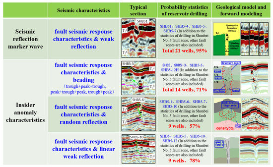
Figure 14.
A seismic identification model of a fault-controlled reservoir in the Shunbei area.
The seismic response characteristics of a fault-controlled fracture cave reservoir are discussed in two parts: seismic reflection marker wave and insider. The seismic identification mode of seismic reflection wave of fault-controlled reservoir is mainly include two response characteristics: “seismic response characteristics & weak reflection” and “red trough anomaly under T74 horizon”. The internal seismic identification mode is mainly include three response characteristics: “fault seismic response characte”ristics & random reflection”, “fault seismic response characteristics & beading” and “fault seismic response characteristics & linear weak reflection”(Figure 14). The “fault seismic response characteristics & beaded” seismic facies is mainly characterized by beaded reflection. The reservoir is located in seismic peak or trough, and the beaded appears in multiple layers, single layers or clusters. The “fault seismic response characteristics & random reflection” seismic facies is characterized by random reflection near the fault. Different from the “fault seismic response characteristics & beads”, the “fault seismic response characteristics & random reflection” seismic facies is irregular in shape. “Fault seismic response characteristics & linear weak reflection” seismic facies reflection features linear weak reflection around the fault zone.
In order to test the accuracy of the seismic identification mode of the fault-controlled reservoir, we found a target of “fault seismic response characteristics & beading” in the No. 8 strike-slip fault zone far away from the study area (Figure 1). This target was named SHB8 well (Figure 15). After drilling, industrial oil and gas flow were obtained. Oil test production was conducted with a daily oil production of 76 tons and a daily gas production of 311,300 m3 at a 7 mm nozzle. The accuracy of seismic recognition mode is verified. In other areas similar to Shunbei, we suggest using this reservoir seismic identification model to find targets near the strike-slip fault zones.
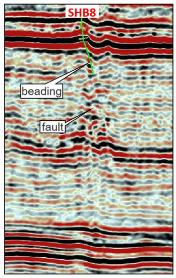
Figure 15.
A seismic profile of the drilling path of the SHB8 well. The seismic data processing migration method is pre-stack reverse time migration (RTM).
6. Conclusions
The research in this paper shows that the seismic identification model of a fault-controlled reservoir is valuable for the identification and prediction of carbonate reservoirs in the Shunbei area of ultra-deep low-quality seismic data. The relationship between complex reservoirs and seismic response characteristics established by this method provides a basis for identifying and characterizing ultra-deep carbonate fault-controlled fracture cave reservoirs using 3D seismic data. When the number of drilling wells is not enough, it is a quick and effective means to establish a regional reservoir seismic identification model through the forward numerical simulation research of the fault zone, fracture cavity theory and drilling seismic geological model, combined with limited drilling statistics. In the seismic identification model of fault-controlled reservoirs of ultra-deep carbonate formations in the Shunbei area, “fault seismic response characteristics & beading” and “fault seismic response characteristics & weak reflection” are the seismic response characteristics of good reservoirs with high probability, which has also been confirmed in the drilling of the SHB8 well.
The seismic identification model of the Shunbei fault-controlled reservoir provides convenience for interpreters to quickly find good reservoirs on 2D seismic profiles. However, we should also realize that different reservoir structures and combination methods may also show the same seismic response characteristics in seismic data, which may result in some reservoirs we find not being in the previously assumed state. We intend to continue to study the geometric and dynamic differences of different reservoir states but the same seismic amplitude response, and obtaining the reservoir seismic identification and prediction technology will be the direction of subsequent research.
Author Contributions
Software; Resources; Writing—review and editing; Project administration, X.W.; Methodology; Validation; Data curation, D.Z.; Validation; Writing-original draft; Writing-review and editing, W.G. All authors have read and agreed to the published version of the manuscript.
Funding
This study was financially supported by the National Natural Science Foundation of China (Grant No. 41774142), the Natural Science Foundation of Sichuan Province of China (Grant No. 2022NSFSC1140), Open Fund (PLC20211101) of State Key Laboratory of Oil and Gas Reservoir Geology and Exploitation (Chengdu University of Technology).
Data Availability Statement
Not applicable.
Conflicts of Interest
The authors declare no conflict of interest.
References
- Liu, J.; Li, Z.; Wang, X.; Jiang, L.; Feng, Y.; Wallace, M.W. Tectonic-fluid evolution of an ultra-deep carbonate reservoir in the southern Halahatang Oilfield area, Tarim Basin, NW China. Mar. Pet. Geol. 2022, 145, 105870. [Google Scholar] [CrossRef]
- Zhang, W.; Duan, T.; Li, M.; Zhao, H.; Shang, X.; Wang, Y. Architecture characterization of Ordovician fault-controlled paleokarst carbonate reservoirs in Tuoputai, Tahe oilfield, Tarim Basin, NW China. Pet. Explor. Dev. 2021, 48, 367–380. [Google Scholar] [CrossRef]
- Duan, T.; Zhang, W.; Lu, X.; Li, M.; Zhao, H.; Shang, X. Architectural characterization of Ordovician fault-controlled paleokarst carbonate reservoirs, Tahe oilfield, China. Interpretation 2020, 8, T953–T965. [Google Scholar] [CrossRef]
- Zhu, W.; Yao, Q.; Li, C.; Chen, Y.; Zhang, Z.; Fang, Q. Hydrocarbon accumulation factors and favorable exploration of carbonate reservoirs in the 3rd-4th members of Ordovician Yingshan Formation of Tazhong Low Salient. Earth Sci. 2022, 29, 743–758. (In Chinese) [Google Scholar] [CrossRef]
- Li, Y.; Sun, J.; Wei, H.; Song, S. Architectural features of fault-controlled karst reservoirs in the Tahe oilfield. J. Pet. Sci. Eng. 2019, 181, 106208. [Google Scholar] [CrossRef]
- Zhou, X.; Pang, X.; Li, Q.; Pang, H.; Xiang, C.; Jiang, Z.; Li, S.; Liu, L. Advances and problems in hydrocarbon exploration in the Tazhong area, Tarim Basin. Pet. Sci. 2010, 7, 164–178. [Google Scholar] [CrossRef]
- Xiang, C.; Pang, X.; Yang, W.; Wang, J.; Li, Q.; Liu, L.; Li, Y. Hydrocarbon migration and accumulation along the fault intersection zone-a case study on the reef-flat systems of the No.1 slope break zone in the Tazhong area, Tarim Basin. Pet. Sci. 2010, 7, 211–225. [Google Scholar] [CrossRef][Green Version]
- Wang, X.; Wang, J.; Cao, Y.; Han, J.; Wu, K.; Liu, Y.; Liu, K.; Xie, M. Characteristics, formation mechanism and evolution model of Ordovician carbonate fault-controlled reservoirs in the Shunnan area of the Shuntuogole lower uplift, Tarim Basin, China. Mar. Pet. Geol. 2022, 145, 105878. [Google Scholar] [CrossRef]
- Yang, P.; Gao, G.; Hou, Y.; Gu, Y.; Dan, G. Seismic acquisition techniques for onshore deep targets: A case study of deep formations in the Tarim Basin. China Pet. Explor. 2016, 21, 61–75. [Google Scholar]
- Li, H.Y.; Liu, J.; Gong, W.; Huang, C.; Ren, L.D. Identification and characterization of strike-slip faults and traps of fault-karst reservoir in Shunbei area. China Pet. Explor. 2020, 25, 108–120. [Google Scholar] [CrossRef]
- Deng, S.; Li, H.L.; Han, J.; Cui, D.Y.; Zou, R. Characteristics of the central segment of Shunbei 5 strike-slip fault zone in Tarim Basin and its geological significance. Oil Gas Geol. 2019, 40, 990–998. [Google Scholar] [CrossRef]
- Zhou, X.Y.; Lv, X.X.; Yang, H.J.; Wang, X.; Yu, H.F.; Cai, J.; Lan, X.D. Effects of strike-slip faults on the differential enrichment of hydrocarbons in the northern slope of Tazhong area. Acta Pet. Sin. 2013, 34, 628–637. [Google Scholar] [CrossRef]
- Huang, T.Z. Structural interpretation and petroleum exploration targets in northern slope of middle Tarim Basin. Pet. Geol. Exp. 2014, 36, 257–267. [Google Scholar] [CrossRef]
- Zhang, Y.T.; Sun, C.; Wang, X.; Yuan, J.Y.; Yin, H.R. Reservoir formation patterns in the strike-slip fault zone of the Halahatang oilfield. J. Southwest Pet. Univ. (Sci. Technol. Ed.) 2020, 42, 10–18. [Google Scholar] [CrossRef]
- Zhang, Y.T.; Deng, X.L.; Wu, G.H.; Xie, Z.; Wan, X.G.; Yang, T.Y. The oil distribution and accumulaiton model along the strik-slip fault zones in Halahatang area, TarimBasin. Chin. J. Geol. 2020, 55, 382–391. [Google Scholar] [CrossRef]
- Jiao, F.Z. Significance of oil and gas exploration in NE strike-slip fault belts in Shuntuoguole area of Tarim Basin. Oil Gas Geol. 2017, 38, 831–839. [Google Scholar] [CrossRef]
- Wang, Q.H.; Yang, H.J.; Wang, R.J.; Li, S.Y.; Deng, X.L.; Li, Y.; Chang, L.J.; Wan, X.G.; Zhang, Y.T. Discovery and exploration technology of fault-controlled large oil and gas fields of ultra-deep formation in strike slip fault zone in Tarim Basin. China Pet. Explor. 2021, 26, 58–71. [Google Scholar] [CrossRef]
- Ma, Y.; Cai, X.; Yun, L.; Li, Z.; Li, H.; Deng, S.; Zhao, P. Practice and theoretical and technical progress in exploration and development of Shunbei ultra-deep carbonate oil and gas field, Tarim Basin, NW China. Pet. Explor. Dev. 2022, 49, 1–20. [Google Scholar] [CrossRef]
- Lü, X.; Yang, H.; Yang, N.; Zhao, F.; Ma, Y. Further Recognition of Petroleum Exploration Potential of Marine Carbonates in Western Tarim Basin. Pet. Sci. 2007, 4, 21–25. [Google Scholar] [CrossRef]
- Jin, Z.; Liu, Q.; Yun, J. Potential petroleum sources and exploration directions around the Manjar Sag in the Tarim Basin. Sci. China Earth Sci. 2017, 60, 235–245. [Google Scholar] [CrossRef]
- Yang, S.; Wu, G.; Zhu, Y.; Zhang, Y.; Zhao, X.; Lu, Z.; Zhang, B. Key oil accumulation periods of ultra-deep fault-controlled oil reservoir in northern Tarim Basin, NW China. Pet. Explor. Dev. 2022, 49, 285–299. [Google Scholar] [CrossRef]
- Yang, P.; Liu, K.; Li, Z.; Mcinnes, B.I.A.; Liu, J. Evolution of Ordovician YJ1X ultra-deep oil reservoir in the Yuecan oilfield, Tarim Basin, NW China. Pet. Explor. Dev. 2022, 49, 300–312. [Google Scholar] [CrossRef]
- Ma, Y.; He, Z.; Zhao, P.; Zhu, P.; Han, J.; You, D.; Zhang, J. A new progress in formation mechanism of deep and ultra-deep carbonate reservoir. Acta Pet. Sin. 2019, 40, 1415–1425. (In Chinese) [Google Scholar] [CrossRef]
- Su, J.; Wang, X.; Yang, H.; Yu, F.; Li, Y.; Ma, S.; Wei, C.; Weng, N.; Yang, Y. Hydrothermal alteration and hydrocarbon accumulations in ultra-deep carbonate reservoirs along a strike-slip fault system, Tarim Basin, NW China. J. Pet. Sci. Eng. 2021, 203, 108605. [Google Scholar] [CrossRef]
- Li, L.; Sun, T.; Chen, Y.; Zhang, Y.; Wang, Y.S.; Wang, S.; Zhao, J.; Wang, Y.D.; Li, D. Study on characteristics of strike-slip faults and exploration of fault-dissolution body in Xiaotangnan area of Tarim Basin. Bull. Geol. Sci. Technol. 2022. (In Chinese) [Google Scholar] [CrossRef]
- Yang, S.B.; Liu, J.; Li, H.L.; Zhang, Z.P.; Li, J.J. Characteristics of the NE-trending strike-slip fault system and its control on oil accumulation in north peri-cline area of the Tazhong paleouplift. Oil Gas Geol. 2013, 34, 797–802. [Google Scholar] [CrossRef]
- Li, X.W.; Feng, X.K.; Liu, Y.L.; Zhang, J.W.; Lv, D.; Han, J.; DH Zhu He, H.Z. Characteristic of the strike-slip faults system and effect of faults on reservoir and hydrocarbon accumulation in Tazhong area, China. Geophys. Prospect. Pet. 2018, 57, 764–774. [Google Scholar] [CrossRef]
- Han, J.F.; Su, Z.; Chen, L.X.; Guo, D.S.; Zhang, Y.T.; Ji, Y.G.; Zhang, H.F.; Yuan, J.Y. Reservoirs-controlling and accumulation-controlling of strike-slip faults and exploration potential in the platform of Tarim Basin. Acta Pet. Sin. 2019, 40, 1296–1310. [Google Scholar] [CrossRef]
- Yun, L. Controlling effect of NE strike slip fault system on reservoir development and hydrocarbon accumulation and its geological significance in the eastern Shunbei area, Tarim Basin. China Pet. Explor. 2021, 26, 41–52. [Google Scholar] [CrossRef]
- Liu, B.Z. Analysis of main controlling factors of oil and gas differential accumulation in Shunbei area, Tarim Basin-taking Shunbei No.1 and No.5 strike slip fault zones as examples. China Pet. Explor. 2020, 25, 83–95. [Google Scholar] [CrossRef]
- Jiao, F.Z. Significance and prospect of ultra-deep carbonate fault-karst reservoirs in Shunbei area, Tarim Basin. Oil & Gas Geol. 2018, 39, 207–216. [Google Scholar] [CrossRef]
- Qi, L.X. Characteristics and inspiration of ultra-deep fault-karst reservoir in the Shunbei area of the Tarim Basin. China Pet. Explor. 2020, 25, 102–111. [Google Scholar] [CrossRef]
- Ren, L.D.; Wang, B.C.; Liu, J. Application of Frequency Attenuation Gradient in Reservoir Prediction in Block Kartake 1 of Tazhong Area. J. Oil Gas Technol. 2012, 34, 59–63. [Google Scholar]
- Yang, J.F.; Guan, D.; Zhu, W.B.; Zhang, X.D.; Xiang, X.M.; Wu, D.L. Carbonate reservoir prediction technology and its application in Ka-1 3D acreage in Tazhong area, Tarim Basin. Oil Gas Geol. 2012, 33, 61–68. [Google Scholar]
- Wang, Q.; Yang, H.; Li, Y.; Lü, X.; Zhang, Y.; Zhang, Y.; Sun, C.; Ouyang, S. Control of strik-skip fault on the large carbonate reservoir in Fuman, Tarim Basin—A reservoir model. Earth Sci. Front. 2022, 29, 239–251. (In Chinese) [Google Scholar] [CrossRef]
- Liu, L.; Sun, S.Z.; Yang, H.; Han, J.; Gao, H.; Jing, B.; Zhu, X. Seismic attributes and integrated prediction of fractured and caved carbonate reservoirs in the Tarim Basin, China. Pet. Sci. 2011, 8, 455–461. [Google Scholar] [CrossRef]
- Zeng, H.; Wang, G.; Janson, X.; Loucks, R.; Xia, Y.; Xu, L.; Yuan, B. Characterizing seismic bright spots in deeply buried, Ordovician Paleokarst strata, Central Tabei uplift, Tarim Basin, Western China. Geophysics 2011, 76, B127–B137. [Google Scholar] [CrossRef]
- Laake, A.; Zhaoming, W.; Gengxin, P.; Duoming, Z.; Yongfu, C. Mapping ultra-deep karst in its geological context. In SEG Technical Program Expanded Abstracts 2014; Society of Exploration Geophysicists: Houston, TX, USA, 2014; pp. 2455–2459. [Google Scholar] [CrossRef]
- Min, X.G.; Gu, H.M.; Zhu, D. Wave equation forward modeling of cavern models in Tahe oilfield. Prog. Explor. Geophys. 2006, 29, 187–191. [Google Scholar]
- Li, G.P.; Cheng, L.M.; Meng, L.Y.; Er, C. High-order Staggered Grid Difference Seismic Wave Simulation in Heterogeneous Media. J. Oil Gas Technol. 2010, 32, 220–224. [Google Scholar]
- Liu, R.E.; Li, W.H.; Chen, M.J.; Zhang, C.L.; Sun, F.J.; Wang, Y.L.; Xiao, H.P.; Lin, J. Reservoir evaluation and exploration prospect of the Member 2 of Shanxi Formation of Lower Permian in eastern Ordos. J. Palaeogeocrahy 2006, 8, 531–538. [Google Scholar]
- Dong, Y.X.; Wang, Z.C.; Zheng, H.J.; Xu, A.N. Control of strike-slip faulting on reservoir formation of oil and gas in Nanpu sag. Pet. Explor. Dev. 2008, 35, 424–430. [Google Scholar] [CrossRef]
- Lei, Q.; Yang, G.; Weng, D.; Liu, H.; Guan, B.; Cai, B.; Fu, H.; Liu, Z.; Duan, Y.; Liang, T.; et al. Techniques for improving fracture-controlled stimulated reservoir volume in ultra-deep fractured tight reservoirs: A case study of Kuqa piedmont clastic reservoirs, Tarim Basin, NW China. Pet. Explor. Dev. 2022, 49, 1169–1184. [Google Scholar] [CrossRef]
- Lu, X.B.; Hu, W.G.; Wang, Y.; Li, X.H.; Li, T.; Lv, Y.P.; He, X.M.; Yang, D.B. Characteristics and development practice of fault-karst carbonate reservoirs in Tahe area, Tarim Basin. Oil Gas Geol. 2015, 36, 347–355. [Google Scholar] [CrossRef]
- Deng, X.L.; Yan, T.; Zhang, Y.T.; Wan, X.G.; Feng, K.; Yuan, A.Y.; Yao, C.; Xiao, C.Y. Characteristics and well location deployment ideas of strike-slip fault controlled carbonate oil and gas reservoirs: A case study of the Tarim Basin. Nat. Gas Ind. 2021, 41, 21–29. [Google Scholar] [CrossRef]
- Li, Z.J. Forward modeling verifies the application of prestack elastic impedance inversion in carbonate reservoir prediction. Geophys. Prospect. Pet. 2013, 52, 323–328. [Google Scholar]
- Ma, L.W.; Gu, H.M.; Zhao, Y.Y.; Chen, D.Y.; Zhao, X.P. Sculpturing platform-edge reef carbonate reservoirs in deep-water with random media forward modeling. Oil Geophys. Prospect. 2014, 48, 583–590. [Google Scholar] [CrossRef]
- Liu, J.; Ren, L.D.; Li, Z.J.; Wang, P.; Yang, Z.C.; Ma, L.W. Seismic identification and evaluation of deep carbonate faults and fractures in Shunnan area, Tarim Basin. Oil Gas Geol. 2017, 38, 703–710. [Google Scholar] [CrossRef]
- Ning, C.Z.; Sun, L.D.; Hu, S.Y.; Xu, H.M.; Pan, W.Q.; Li, Y.; Zhao, K.Z. Karst types and characteristics of the Ordovician fracture-cavity type carbonate reservoirs in Halahatang oilfield, Tarim Basin. Acta Pet. Sin. 2021, 42, 15–32. [Google Scholar] [CrossRef]
- Zhu, D.Y.; Meng, Q.Q.; Jin, Z.J.; Hu, W.X. Carbonate Reservoir Rock of Composite Genesis and Its Dynamic Developing Process:An Example from Tahe Carbonate Reservoir. Nat. Gas Geosci. 2012, 23, 26–35. [Google Scholar]
- Kang, Z.J.; Li, H.K. Characteristics of Ordovician carbonate reservoirs in Tahe oilfield. Pet. Geol. Oilfield Dev. Daqing 2014, 33, 21–26. [Google Scholar] [CrossRef]
- Liu, B.Z.; Qi, L.X.; Li, Z.J.; Liu, J.; Huang, C.; Yang, L.; Ma, L.W.; Gong, W. Spatial characterization and quantitative description technology for ultra-deep fault-karst reservoirs in the Shunbei area. Acta Pet. Sin. 2020, 41, 413–414. [Google Scholar] [CrossRef]


Publisher’s Note: MDPI stays neutral with regard to jurisdictional claims in published maps and institutional affiliations. |
© 2022 by the authors. Licensee MDPI, Basel, Switzerland. This article is an open access article distributed under the terms and conditions of the Creative Commons Attribution (CC BY) license (https://creativecommons.org/licenses/by/4.0/).