Article

Enhancing Urban Heating Systems Planning through Spatially Explicit Participatory Modeling

Division of Energy Technology, Department of Space, Earth and Environment, Chalmers University of Technology, 41296 Gothenburg, Sweden
*
Author to whom correspondence should be addressed.
Energies 2023, 16(11), 4264; https://doi.org/10.3390/en16114264
Submission received: 9 April 2023 / Revised: 10 May 2023 / Accepted: 19 May 2023 / Published: 23 May 2023

Abstract

:
Effective planning of urban heating systems is crucial for achieving net-zero emissions at the city level. In particular, the spatial dimension plays a pivotal role in shaping the design and operation of these systems. Nonetheless, the integration of urban spatial and energy planning is rarely performed. To address this deficit, the current study proposes a participatory modeling methodology that explicitly incorporates the spatial dimension to facilitate integration and decision-making in the planning of urban heating systems. The methodology is applied to a case municipality to evaluate its benefits and implications for stakeholders involved in urban heat planning. The results reveal that the participatory nature of the methodology enhances the legitimacy, transparency, and relevance of the modeling process by engaging urban stakeholders, so as to exploit their valuable knowledge, experience, and understanding of the local context and related challenges. The developed methodology provides a spatial representation of district heating expansion, heating technology transition at the district-building level, and the installed capacities in each district, thereby improving the coherence of urban heat planning integrated with other urban plans. Consequently, the incorporation of the spatial dimension adds a nuanced layer of modeling outcomes to standard city level optimization models.

1. Introduction

1.1. Introduction to the Study

Urban areas account for 75% of global carbon dioxide (CO2) emissions, with the transport and building sectors being the major contributors [1]. Energy use in buildings makes up 40% of the total primary energy consumption in EU member states, of which 80% is linked to space heating and hot water production [2]. Overall, 73% of the heat is still generated from fossil fuels [3], which means that there is an urgent need to shift the heating sector towards an efficient and fossil-free system, so as to reduce CO2 emissions in urban areas. In order to achieve a transition in systems, the role of urban heating systems planning is especially important.
Spatial aspects are of importance in heat planning, since heat supply decisions should be based on knowledge of the spatial placement of the heat demand and its density and location, as well as the distribution of different building archetypes [4]. To support energy and urban planners with urban heating systems planning, an integrative perspective that incorporates both the spatial aspects and energy issues is needed. However, energy planning and urban spatial planning typically fall under the responsibility of different departments, leading to distinct planning processes. This separation may result in cities experiencing difficulty in reaching their climate goals, as a lack of coordination may result in conflicting strategies.
A participatory approach can facilitate the integration of urban and energy planning. Since municipalities, as local authorities, can promote low-carbon energy systems transitions through decision and policymaking with regards to energy planning and energy efficiency, they are considered the key actors when it comes to the implementation of energy strategies at the local level [5]. In addition, municipality officials usually have expert knowledge, experience, and understanding of the local context and its challenges, such as geographic conditions and community functions, which are essential components of the planning process.
The purpose of this study is to develop a modeling methodology that takes into account both urban and energy planning considerations in a spatially explicit manner, together with the active participation of stakeholders. This methodology will be applied to a specific municipality to evaluate and analyze its effectiveness. We address the following research questions throughout the study: (1) In what ways can an energy systems model incorporate the spatial dimensions of urban planning in a clear and direct manner? (2) How can the participation of stakeholders be utilized effectively to enhance the usefulness of energy systems modeling in municipal contexts? (3) What advantages can be gained in terms of urban energy planning through the use of a participatory modeling methodology that explicitly accounts for spatial considerations?
This study is structured as follows. The next section consists of a review of the relevant literature. Section 2 presents the development of the spatially explicit participatory modeling methodology. In Section 3, the methodology is applied to a case municipality and the entire modeling process is presented and discussed. Section 4 presents the modeling results and discusses its use and benefits for the stakeholder, and this is followed by an analysis, evaluation, and discussion of the methodology in Section 5. Finally, Section 6 outlines the conclusions drawn from this study.

1.2. Literature Review

Climate change has emerged as a significant motivating factor for studies that have focused on identifying strategies and short- and long-term pathways to decrease emissions of greenhouse gases [6]. Energy Systems Modeling (ESM) has proven to be a useful tool for such purposes, due to its ability to represent the interactions of multiple components of the energy systems, e.g., the energy resource, the conversion technologies, and the energy demand sectors, based on mathematical formulations [7,8]. While ESM is able to provide valuable insights into the feasibility of future energy systems, with various approaches being available depending on the purpose, it generally lacks the spatial dimension of energy planning.
However, some studies have, attempted to address the spatial dimension in heat planning [9,10,11]. Steingrube et al. [10] presented a modeling framework that features a high level of spatial resolution, i.e., at the street segment level (higher resolution including more segments), to determine the optimal level of centralized heating and grid layout. They combined two established tools: a building energy demand simulation model and an energy systems optimization model. Jalil-Vega and Hawkes [9] investigated the impacts of three different levels of spatial resolution. They stressed the importance of finer spatial resolution for heating grid-related decision makers, as this provides more detailed information on zones that would benefit to a greater extent or more rapidly from the grid. In the paper by Lichtenwoehrer et al. [11], a holistic methodology that combines the economic, material, energetic, and spatial aspects developed by Erker et al. [12] was used to assess the suitability of district heating (DH) networks in several Austrian cases. In their work, five spatial characteristics were considered: the size of the study area, the construction period of the buildings, the building typology, the building type of use, and the building density. Geographic Information Systems (GIS) have been shown to be a valuable tool for supporting both heat and spatial planning [4,13,14,15,16]. A shortcoming of such an approach is that it relies heavily on the availability and quality of spatial data, e.g., street and building spatial allocations, which are not always accessible.
The spatial aspects are addressed and handled in municipal urban spatial planning. Despite the importance of spatial aspects in heat planning, the integration of urban and energy planning is not commonly performed. Nadin et al. [17] conducted a comparative study of spatial planning systems in European countries and showed that at the local level, there is a limited capacity to integrate spatial planning with other sectoral policies, e.g., energy policy. Cajot et al. [18] reported that the lack of such integration is mostly because there are no clearly defined methodologies or appropriate decision support tools. Another obstacle is the communication barrier inherent to the different backgrounds of the two disciplines, i.e., physical versus visual sciences [19]. As the spatial characteristics of urban areas are directly related to energy consumption and efficiency [20], multi-domain integration to combine the tools and knowledge from urban and energy planning can play a role in urban energy systems transitions. This type of integration has been called for by several authors [18,21,22,23].
A participatory research approach offers a means to incorporate the bottom-up knowledge provided by stakeholders and can assist their decision-making processes. Moreover, the participation of stakeholders from different backgrounds brings benefits to the planning process [5] and increases opportunities for knowledge exchange [24], which is claimed to be important for successful transitions [25]. Another advantage of a participatory approach is the improved legitimacy of decisions, meaning that decisions that reflect stakeholders’ needs and preferences may be regarded as more legitimate and easier to implement [26].
Participatory research approaches have been discussed in many areas of environmental policy, but they are uncommon in the energy field [24] and even less common in energy systems modeling research [27]. By involving external stakeholders who do not work with energy models in the modeling process, the interaction between scientists and decision-makers can be improved [28], and it can foster legitimate decisions through reflections of their positive and negative feedback [29]. Considering the direct impact on energy planning that stakeholders can have, their participation in the modeling process has the possibility to drive the best possible outcomes. In addition, such an approach is expected to improve the energy models and their levels of transparency, and to exploit their full potential for supporting energy systems transitions.
Previous studies have contributed to and deployed stakeholder participation-based methodologies in energy and environment modeling studies [24,30,31,32,33,34,35,36]. However, they did not utilize ESM [24,31,32] and did not include the modeling process itself [31,33,34], but instead comprised discussions of different approaches to including stakeholders in the energy systems modeling and planning and the benefits thereof. One study [37] used a branch of game theory to study the allocation of the emission cap with assumed participants, prosumers, who are not directly involved in energy planning, as in the current study. A modeling study starts with data collection, proceeds with the identification of target problems, and goes beyond the analysis of the modeling results [34]. With this perspective in mind, the methodology developed by Yu et al. [30] shows how stakeholders’ participation can be incorporated into the entire energy systems modeling process.
Although the abovementioned studies represent attempts to consider spatial aspects in energy/heat planning to capture the spatial impacts, an integrative method for heat planning that incorporates the urban planning side is lacking. Since urban planners can influence the possibilities to employ renewable energy and energy efficiency during the early stages of the urban spatial planning process [19], the lack of an integrative approach may lead to missed opportunities in terms of cost-efficient energy transition options [38].

2. Methods

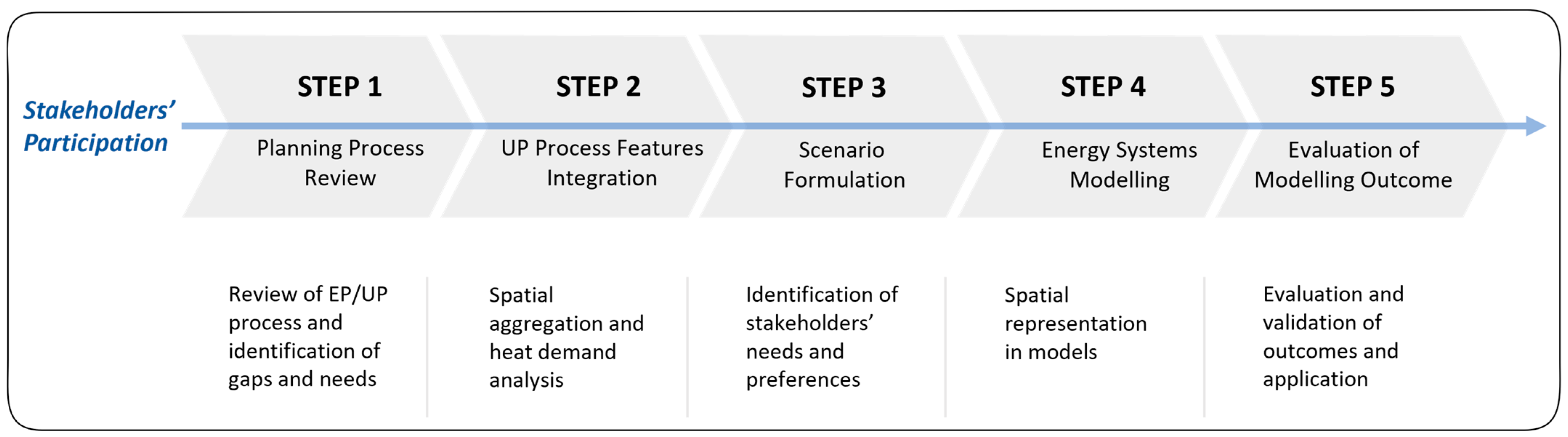
2.1. Participatory Modeling Methodology for Local Heat Planning

With the aims of proposing, developing, and applying an integrative methodology that allows stakeholders from different domains to participate in the energy modeling process, this study adopts and expands the participatory methodology developed and presented by Yu et al. [30]. As shown in Figure 1, this methodology consists of five steps, covering the whole process of spatially explicit energy systems modeling (heating systems in this study) and based on stakeholder participation.
The five steps of the methodology are described in the following subsections. While Yu et al. [30] only addressed the first two steps, the present study addresses all five steps. Through its application to a case municipality, the robustness of the methodology is evaluated and discussed.

2.1.1. Step 1: Planning Process Review

First, the energy and urban planning processes are analyzed to identify the needs, challenges, and preferences from both the energy and urban planning perspectives. After reviewing the official publications of the municipal plans, an empirical research approach, e.g., semi-structured interviews with stakeholders, is adopted for Step 1. Once the documents are reviewed, a questionnaire that forms the basis for the stakeholder interviews is formulated. The questions concern:
  • Planning goals and challenges;
  • Specific process description of energy and urban planning;
  • How the interaction between the two planning processes occurs;
  • Different rules and ordinances affecting the planning processes;
  • Important information exchange for the planning tasks;
  • Clarification of the reviewed documents.
After the documentation review and communication with stakeholders/incumbents have been performed and empirical knowledge has been obtained, the necessary information to support the integration is extracted using an analysis of the planning processes. For an overview of Step 1, see Figure 2.

2.1.2. Step 2: UP Process Features Integration

Certain urban spatial features are identified and integrated into the energy systems model by making the information amenable to modeling in Step 2. Features of the urban planning process that have been incorporated into energy systems planning studies in previous studies include spatial/zoning plans, density, land use, urban form, and building information [30]. Two features that are identified as being directly related to energy consumption and that must be integrated into the model are (1) the official urban territorial subdivision and its density and (2) building information. With this information, spatial aggregation and a building energy demand analysis are carried out in Step 2.
Spatial aggregation allows one to link the urban plan to the energy plan and to define new districts that correspond to the official urban cadastral subdivision. Urban spatial characteristics are related to energy consumption and the access to certain technologies that are affected by these spatial characteristics [39,40]. Thus, these determining characteristics, e.g., the building type, distance to energy-producing technologies, and energy demand density, should be taken into account in the spatial aggregation. The applicable information sources for spatial aggregation include municipal plans and national/local statistics on energy technologies. Municipal planners can provide their preferences, as well as information that is difficult to obtain from public documents.
The building information, i.e., the type, age, and size of buildings, is one of the factors that affect the energy consumption and energy performance of the building [41,42]. The building energy demand in each of the identified districts is calculated using the data on building information in this step. Information of this type is usually available from the national building registry database. As a result, new districts are defined with specific building information of corresponding districts, and their energy demands are estimated based on the available data, serving as important parameters in the energy systems modeling in the subsequent steps.

2.1.3. Step 3: Scenario Formulation

Scenario planning is used to explore different possible futures and uncertainties, rather than for making a single outcome prediction [43]. The impact of uncertainties on scenario planning may be reduced if the scenarios are formulated based on discussions with energy planning-related stakeholders rather than on assumptions by the modelers alone [44]; this is one of the novelties of our study. Municipality energy scenarios are formulated in Step 3 in a participatory approach through various types of contact, e.g., interviews, workshops, and email communications, based on a provided outline. The outline offers stakeholders the basis for possible scenarios in the form of various options based on communication with them, i.e., constraints that should be binding in the model, different settings of the model parameter values, and the option to select and combine different elements in order to formulate scenarios (see Figure 3).
Stakeholders receive opportunities to express what they need to observe and what types of modeling outcomes they would need to utilize as a decision support tool. Weaknesses of the model can also be addressed by discussing the compatibility of the modeling outcomes with the social and economic realities of the scenarios [45]. The following points are considered relevant to discuss during communication with municipality stakeholders: locally set climate goals, technology preferences, national energy policies, upcoming investment plans, expected structural changes, and geographic/environmental limitations. This involvement of the stakeholders promotes not only the robustness of the scenarios, but also their applicability levels.

2.1.4. Step 4: Energy Systems Modeling

One of the main objectives of energy systems modeling is to support decision-makers and planners by providing knowledge regarding possible outcomes, which are generated through investigations of energy transition strategies and policies [33]. The necessary input data and assumptions for the modeling work are communicated and supplemented by energy and urban planning stakeholders in Step 4, so as to increase the transparency, legitimacy, and relevance of the model/modeling outcomes for their planning work. Prior to communicating to validate and discuss input data and model assumptions, it is necessary to consider what type of energy systems model would be suitable for the purpose of decision support in long-term energy planning.
The methodology of this study requires a model that can provide an overall picture of the long-term future energy systems while reaching the climate goal. Energy Systems Optimization Models (ESOMs) provide insight for system development using linear programming techniques, and can represent robust tools for analyzing the dynamics in energy systems [46]. A linear program can be expressed mathematically, as in Equation (1):
Minimize   or   maximize   C T x ,   subject   to   Ax     b   and   x     0
where x is a vector of the decision variables, C is a vector of the coefficients that determine the objective function to be minimized or maximized, A is a matrix of coefficients that represent the constraints imposed on the decision variables, and b is a vector of constant terms that define the limits of the constraints [47]. In the case of ESOMs, the decision variables may represent energy generation capacity, technology deployment, energy demand or other relevant quantities, while the constraints may represent physical and technical limitations, environmental targets, economic considerations, or policy goals. By solving the linear program, an ESOM can generate optimal solutions for the energy system under consideration and may provide valuable insight into the potential impacts of different policies and strategies on the system’s performance.
The selection of an ESOM is, therefore, considered appropriate. DeCarolis et al. [48] identified four analytical strengths of ESOMs. To begin with, ESOMs can provide a reliable system for defining the technological and economic performance features of all the modeled processes. Additionally, the model design permits rapid and efficient normative goal seeking in intricate systems. Furthermore, the outcomes of the model can indicate a diverse selection of energy possibilities that align with energy and environmental policies. Lastly, the authors contend that ESOMs have the ability to account for interactions between different sectors, which can yield valuable insight that may be difficult to obtain using models specific to a single sector [48]. The optimization models’ outputs include future technology capacity and generation, marginal commodity prices, the total system cost, and emissions across the modeled energy system.

2.1.5. Step 5: Evaluation of Modeling Outcome

A spatially explicit ESOM can provide district-building-level solutions. The outcomes of the model are communicated, validated, and discussed with the stakeholders in Step 5 through various channels, such as workshops and project meetings, to adjust the model and assess its relevance and usability. Stakeholders are informed as to how the model works and what they can expect from the model in advance, after which, they give feedback and suggest changes according to their needs. This facilitates iterative development of the model between Step 3, Step 4, and Step 5. The model outcome includes energy production per district and building type, capacities of conversion and production plants, CO2 emissions over time, and the total system cost.

3. Results and Analysis—Application to a Case Municipality

The municipality of Lyngby-Taarbæk (LTK), located in the northern suburbs of Copenhagen in Denmark, was chosen as the case municipality due to its current phase of heating system transition. As of 2022, the municipality has a population of 57,826 residing within an area of 38.88 square km. This equates to a population density of approximately 1500 individuals per square kilometer. Considering that the municipality has a relatively high population density [49], which implies that residential buildings make up most of the urban area, providing heating to these houses is a crucial aspect of energy and urban planning. Given that the methodology is dependent upon stakeholder participation and that their needs are the driver for the modeling process, the strong interests of the municipality stakeholders in investigating different heating options will facilitate the application of the methodology. In the LTK case, the planners who are relevant to heat planning represent the municipality stakeholders.
In LTK, the majority (around 60%) of the buildings in the municipality are heated with natural gas. The recent heat plan, approved in early 2022, assigns the focus of their heat plan to DH expansion in areas of high heat consumption where the building density is relatively high. The municipality has been making efforts to expand the DH network to areas where a strong gain in terms of CO2 emissions reduction through reduced usage of fossil fuels for heating could be achieved at low cost. This would lower the municipality’s dependence upon fossil energy sources, allowing it to achieve the goal of being CO2-neutral by the year 2035 [50]. The following sections describe the application of the five steps of the methodology to the case municipality.

3.1. Step 1: Planning Process Review

Both heat and urban planning processes were analyzed based on planning document reviews and semi-structured interviews with municipality stakeholders. The purpose of the interviews was to learn about the current planning process practices, so as to identify the challenges related to heat and urban planning integration, as well as to identify the stakeholders’ needs and preferences (Table 1). The interviewed stakeholders included heat planners, a climate coordinator, and an urban planner. During the interviews, the stakeholders provided an overview of their respective planning processes and the associated challenges, and described the cooperation between the two municipality departments.
It is clear that the two planning processes are comparable to each other. The processes start with the submission of proposals for new projects and, thereafter, there are several reviews and public hearings engaging multiple stakeholders. The processes finish with approval being granted by the responsible politicians. The entire process takes about 6 months, on average, in both cases. The main integration obstacles are (1) heat planning being highly dependent upon consultants, causing the work focus to be mostly on the technical aspects and (2) the lack of means in urban planning departments to include heat-related information in their daily work. The first point is related to what Nuorkivi and Ahonen [19] pointed out about different backgrounds of urban and energy planners, i.e., visual science-based versus technical/engineering-based. The second point is more of a systemic obstacle since the regulations and national law with which urban planners must comply have a weak focus on energy/heating. These two current obstacles indicate that a heat planning tool that enables integration with urban planning aspects would be beneficial in providing more coherent and integrative urban heat planning.

3.2. Step 2: UP Process Features Integration

As described in Section 2.1.2, two features of the urban planning process are considered important to take into account in the heating systems model: (1) official urban cadastral subdivisions or districts and (2) building information. In the following sections, the process of integrating these two features into the heating system model will be explained.

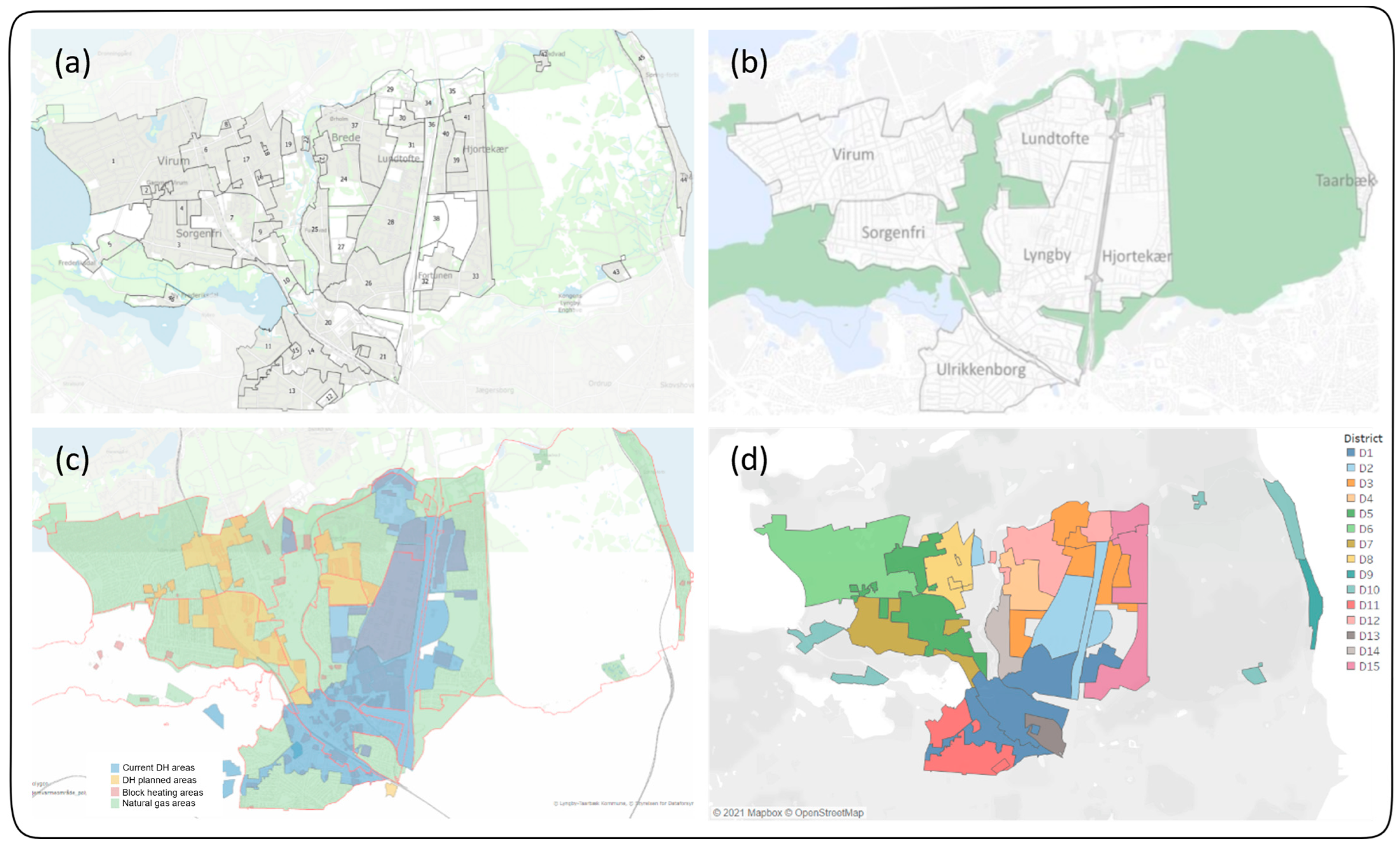
3.2.1. Spatial Aggregation

The municipality stakeholders expressed the need to define new districts for heat planning. This is because the establishment of new districts enables the municipal planners to identify and prioritize areas for DH expansion using a detailed feasibility analysis. Therefore, the new districts should be determined based on the relevant spatial information. In the case of LTK, three maps containing different items of information from urban and heat planning documents are combined to draw up the new districts (see Figure 4). First, the existing geographic divisions of the municipality in the national building and dwelling registry (BBR) serve as the basic framework. In Denmark, for each individual building and residential or business unit, its identification, location, purpose, year of construction, technical conditions, and power/heating installation are registered in The Central Register of Buildings and Dwellings (BBR). Although the BBR is maintained by the Ministry of Housing, Urban and Rural Affairs, it is the property owners’ responsibility to provide input data and to ensure that the BBR information for their property is accurate. Such information is used for various purposes by state and municipal officials, as well as by private companies. The municipality’s official urban quarter divisions and current heating supply structure are used to define the new districts. Updated information on the DH and natural gas grid infrastructure can be found in PlansystemDK “https://kort.plandata.dk/spatialmap (accessed on 9 April 2023)”, which is a public database used by all Danish municipalities. With this combination of sources, the communication with the municipal planners continuously feeds their preferences into the process. As a result, 15 new districts are identified, as shown in Figure 4d. The maps are overlaid in QGIS Desktop 3.18.2, and the coupled BBR data in Figure 4a is provided with the necessary information, e.g., floor area, building numbers, building type, construction year, for the following section to be fed into the modeling tool as input data.

3.2.2. Building Heat Demand Analysis

Building heat demand calculations are carried out based on the selected variables from the BBR. The selected variables include the building type, living area, building age, and location. All the buildings in the case municipality are categorized into six different building types: detached houses and farmhouses; terraced and semi-detached houses; multi-dwelling buildings; student housing and community residential buildings; non-residential buildings, i.e., Residential 1 to 5; and commercial. In addition, they are divided into three building age groups: built before 1960; built between 1961 and 2006; and built in 2007 or later. The total heat demand of the buildings was calculated by multiplying the net floor area by the average annual heat consumption (in kWh per square meter) for each building type, age group, and district. The average values were obtained from the project Energiforbrug i Bygninger (Energy Consumption in Buildings) [57]. The building type distribution in the case municipality shows that Residential 1 and Residential 2 are the predominant building types. Table 2 shows an overview of the building heat demand analysis.

3.3. Step 3: Scenario Formulation

To understand the future vision of the municipality and to develop consistent and tailored scenarios, several aspects need to be communicated, e.g., the preferences for specific technologies, locally set climate goals, upcoming investment plans, and structural changes expected in the municipality, as well as geographic and environmental limitations linked to the investments. Several municipality heating systems transition scenarios were formulated based on the municipal plans and visions with different levels of detail. The scenario formulation started with setting the municipal climate goals, i.e., a specific CO2 emissions reduction target and phasing out of fossil-based technologies, and investigating the heating technologies that are being discussed in the municipality. One of the benefits of formulating scenarios based on stakeholders’ participation is that they can provide a local-specific experience, which can affect the list of parameters in the model. This aspect is helpful in delimiting the modeling scope and making the model more relevant and customized to the case municipality. An overview of the parameters determining the scenarios is presented in Figure 5.
In any scenario, the climate goals of achieving 25% CO2 reduction compared to the level in 2018 by the year 2025 and net-zero emissions by the year 2050 should be met, and natural gas- and oil-fired heating should be phased out by the year 2035. While attempting to reach these goals, four parameters (heat pump subsidy, renovation, electricity price, and individual heating investment) have been selected as the deterministic parameters for the scenarios. The selection reflects the stakeholders’ input and some of the important points, including the following: “…in general, we will work on renovation scenario because people are looking at more house renovations because of high energy prices on both electricity and natural gas” [55]. “Individual heating scenario is very likely. But focus will be stage 1. There will be some HP remained but will mostly be district heating. Some of the very relevant areas would be one in the top left (District 6), they get the DH at the latest so it is very relevant to look at other possibilities” [53].

3.3.1. HP Subsidy

There is a central government subsidy scheme for heat pumps (HPs) in Denmark that is administered by the Danish Energy Agency. Currently, the subsidy covers 15% (up to a maximum of 20%) of the market price of the HPs [58]. In addition, to be subsidized, the building should not be located in a DH area [58,59]. This scenario investigates the impacts of the subsidy on individual HP investments by reducing the investment cost by 20% in the model.

3.3.2. Renovation

This parameter investigates the impact of renovation of the existing buildings in the municipality. The current building renovation practice in Europe reduces energy consumption by 1% annually on average [60]. In 2020, the European Commission introduced a strategy called “A Renovation Wave for Europe”, which is aimed at greater renovation by doubling the annual energy renovation rate over the next 10 years. The term EU Ave in the scenario matrix (see Figure 5) refers to the current building renovation practice, implying a 1% annual reduction in heat consumption, while EU Wave indicates deeper renovation that results in an 18% reduction of heat consumption by the year 2030, as compared to the level in 2015 [60].

3.3.3. Electricity Price

The seasonal electricity price in the base year, i.e., 2021, was taken from Nordpool “https://www.nordpoolgroup.com/en/ (accessed on 9 April 2023)”, and the average seasonal prices for the last 5 years have been calculated. Three different electricity price levels were applied to address the impacts on both electricity-generating (combined heat and power, CHP) and electricity-consuming (HPs and electric boilers) heating technologies.

3.3.4. Individual Heating Investment

In the latest heating plan of the case municipality, the current natural gas areas are divided into two groups, representing two different stages, depending on when the DH is likely to reach the respective areas. Stage 1 (S1) areas may acquire DH during the next 5 years, while Stage 2 (S2) areas may only receive DH when the Stage 1 expansion is completed [50]. This parameter will investigate the heat production in the areas that are waiting for the connection when DH is being expanded within the municipality, which is in accordance with the need expressed by the stakeholder: “The relevance for stage 1 (S1) will be district heating expansion scenario and stage 2 (S2) will be relevant to look at other scenarios …” [53].

3.4. Step 4: Energy Systems Modeling

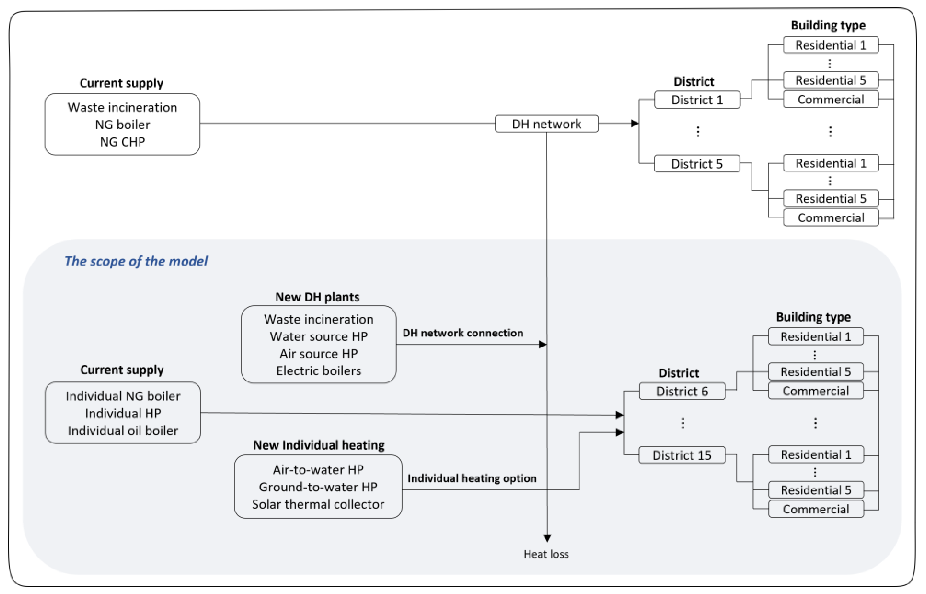
3.4.1. Model Description

The ESOM TIMES (Integrated MARKAL-EFOM Systems) are adopted for the modeling. TIMES is a cost-optimization linear programming model that optimizes the total system cost over the chosen time horizon [61]. The intervals between the years up to the final year and the division of a year into multiple time-slices, e.g., seasonal or diurnal, can be designed according to the desired model outcomes for the questions asked. It is based on perfect foresight, meaning that the model knows the exact heat demand and costs for everything in any future time-slice. The model should exogenously meet the given heat demands at any time-slice and the input, i.e., the techno-economic data, such as investment costs, fuel costs, operation and maintenance (O&M) costs, and efficiency levels of different type of technologies, are given by the modelers. The generated results will then show the heating technology dispatch for every technology and for every time-slice, as well as the cost-optimal investment in new production capacity. The output also includes the total system cost for the entire chosen time horizon and its carbon emissions. In Section 3.4.2, the spatial considerations will further explain how the model represents the “where”.

3.4.2. Spatial Considerations and Model Components

To represent spatial considerations in the model, the 15 districts newly established in Step 2 are considered model regions (REGs). The model here means a set of data files—spreadsheets describing the studied energy system in terms of technologies, commodities, resources, and demands for energy services—and is compatible with a model management tool [62]. Adding multiple districts to the model means that the model will need multiple spreadsheets that represent each supply system in each district. The input data given to the model, i.e., the heat demands per time-slice, supply technology, and techno-economic data, are unique for each district. Accordingly, the objective function (Equation (2)) minimizing the total system cost for the entire chosen time horizon is the sum of the total system costs for all the districts:
OBJ ( t ) = r = 0 R   y   ( 1 + d r , y ) R E F Y y A N N C O S T r , y
The objective function includes the costs for investment, operation, maintenance, and activities, as well as end-of-life costs. The term d r , y is the discount rate by region r, year y, and the base year REFY. A N N C O S T r , y indicates the annual costs over region r in year y. The goal is to minimize the objective function [63]. In this study, the term ”region” in the objective function can be substituted with districts to allow representation of the spatially different (small) systems in each district. The decision variables include the capacity addition, i.e., investment, for technology p, in period v, and region r ( C p , v , r ), and the production by process p, in region r, and period t ( G r ,   t ,   p ). In addition to the main types of constraints that must be satisfied in order to accurately portray the energy system in question (Equations (3) and (4)), a few constraints are imposed via specific parameters set by the modeler. The additional constraints in this study include emission targets, a ban on natural gas, an imposed CO2 tax, and the HP subsidy.
p   G r , t , p     D t , r
where D t is the heat demand in time t in region r.
G r , t , p     C p , v , r

3.4.3. Model Development

This section presents how the heating systems model is built based on the municipal stakeholders’ participation and describes the assumptions that are made. The heat demand of each district is exogenously given. Only areas that are currently being supplied with natural gas, i.e., Districts 6–15, are modeled. The remainder of the municipality, which is already connected to the existing DH network, i.e., Districts 1–5, is assumed to continue using the current heat supply option in the future. Two levels of heat supply technologies are given: individual heating and communal heating technologies, i.e., DH. The former includes small HPs, gas boilers, and solar collectors supplying heat to individual dwellings (Appendix A), while the latter includes large-scale HPs, electric boilers, and waste incineration units supplying heat to the heat networks (Appendix B). In other words, the DH customers receive their heat through the heat network, which is in turn connected to the plants supplying the DH. Prices for different fuels are exogenously given to the model (Appendix C). Figure 6 shows the structure of the developed model.
The spatial aggregation and the building heat demand analysis carried out in Step 2 provided the base structure of the model. Once the spatial aspects were set, the heat supply technologies were investigated and selected with the stakeholders. The role of the participating stakeholders in Step 4 is to discuss the model technology options that are locally available and that are viable in the local context according to the municipal internal dialogues [53,54]: “…Not sure if there will be large scale air source heat pumps (in the new district heating plants options). Maybe. Probably very noisy. Theoretically possible but electric boiler will be there and will be the backup system for district heating and geothermal is a long term, five-six-ten years from now, to be part of the district heating system in the future. Also, (we are) looking at ground water heat pumps as these areas where you have to pump away ground water because it is too close to the surface, also we would like to use excess heat from those pumps.” [53]. In addition, the stakeholders supplemented technical data for the existing heat supply plants. The techno-economic data for the existing and new technologies were obtained from the Danish Energy Agency [64,65]. The cost assumptions for the DH connection, i.e., distribution, transmission piping, and substation costs, were calculated based on [66]. For details, see Table A3 in Appendix B.

3.5. Step 5: Evaluation of Modeling Outcome

The modeling work was presented and communicated during and after the modeling process to obtain the stakeholders’ opinions regarding relevance and usability. These have been used to adjust the model in an iterative manner. When the preliminary modeling outcomes were presented to the stakeholders, they expressed what they wished to learn from the scenario modeling and its outcomes.
The stakeholder input included the relevance of the scenarios to certain districts, how the model outcomes could be used for their heat planning, obstacles to the installation of certain technologies, and which types of information the urban planner will obtain from the model. Some samples of the stakeholders’ reflections are as follows: “…There are a lot of demand from the citizen for district heating. For them, it is a question whether if they should wait for district heating or get another individual heating.” [55]. “…In general, in Lyngby (municipality), people want to have district heating also because of all the discussion about noise issues. So, if they don’t have the ability to make brine water heat pump, they would go for district heating if possible. I would expect that if people have brine water heat pump, then, they will not likely to choose district heating unless the electricity price goes really high. But (with) air to water heat pump, they would change to district heating at some stage. A lot of people are thinking of leasing air to water heat pump for the time until they get district heating.” [53]. “…And for us, when we negotiate with district heating company, we can use our own calculation and our expectations (on) what people choose when they wait for getting district heating. Then it is becoming very relevant with renovation scenario because it is everyone’s interest with the reduced consumption. Then it is also easier for district heating (company) to expand as far as possible and people are also very aware of this.” [53].

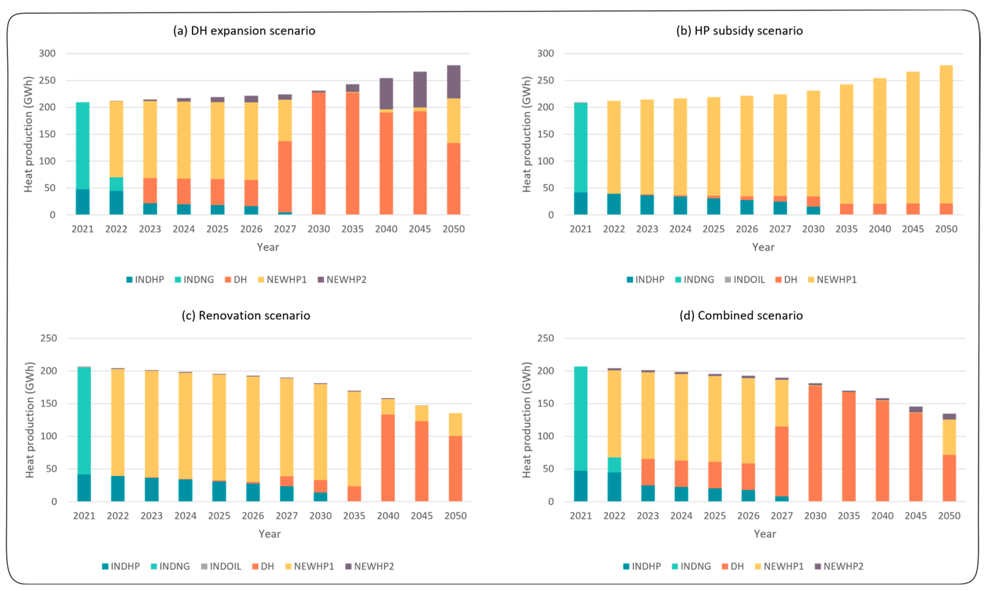
4. Modeling Results and Use

The process of applying the developed modeling methodology to the municipality has generated numerous graphs presenting various long-term heating pathways, not only at the municipality level, but also at the district and building levels. Since the focus is on the assessment of the benefits of the methodology for urban heat planning, the selected modeling results exemplifying how the applied methodology can contribute to heat planning are presented. The selected results include spatial overviews of the DH network expansion, heat production by building type in the districts, and future installed capacities of different scenarios in the districts. The presented examples have been selected based on the following criteria: (1) the addition of a new layer of information to those generated in previous energy systems modeling studies and (2) the provision of what the municipality stakeholders seek to learn from the model. Figure 7 shows an overview of how the annual heat production mix changes over time in each scenario. Together with the heat capacity mix, CO2 emissions, and total system cost, these are the general outputs of ESOMs.

4.1. Spatial Representation of District Heating Expansion

The modeling outcome can depict the spatial distribution of the DH network expansion over the chosen time horizon, i.e., revealing cost-efficient district-by-district DH expansion over time. The outcome also shows the temporal evolution of the DH connections by building type in each district, which depends on the following factors: distance to the existing network, heat demand density, and building type, all of which directly affect the costs for distribution and transmission pipes.
Figure 8 shows how the DH network may expand over time in a DH-favorable scenario. Starting from the current DH network (light-blue districts), the network connection expands to the surrounding districts (dark-blue districts) in a cost-optimal way, depending on multiple factors that affect the connection cost.
Municipal planners rely on such information not only for their planning tasks, but also for engaging in constructive dialogue with DH companies that operate within their jurisdictions. Using such model outcomes, planners can suggest different alternatives for prioritizing areas and buildings for DH connections. This means that planners can work closely with DH companies to develop expansion plans that are efficient, effective, and sustainable. Overall, having access to this type of information is critical for municipal planners, as it helps them to make informed decisions and to develop strategies for expanding DH networks in their districts.

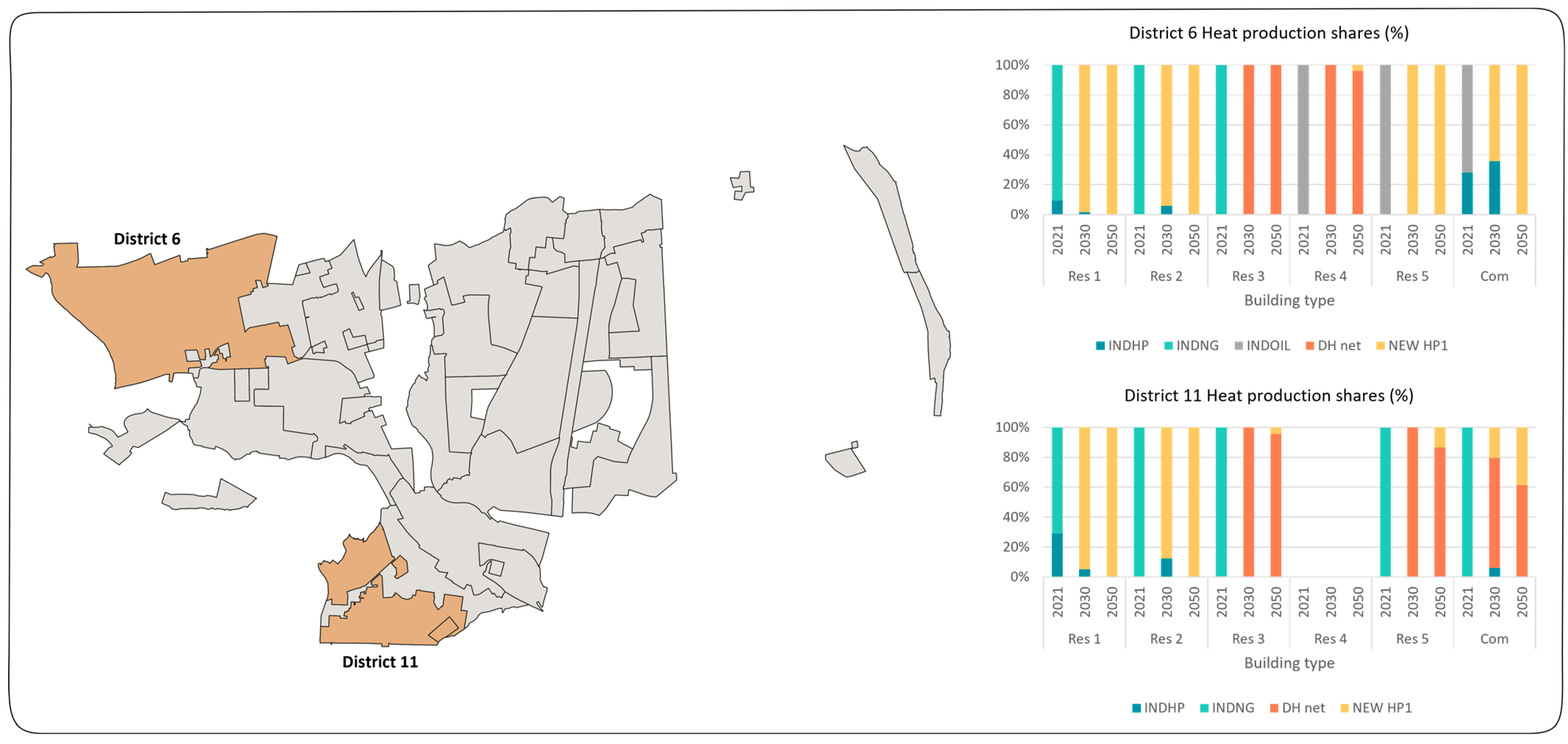
4.2. Heat Production Transition at the District-Building Level

Furthermore, the modeling outcome presents the annual heat production shares in the different building types (residential 1–5 and commercial buildings) in the modeled districts. This allows comparisons of scenario-dependent variations of the heat production mix transitions at the building-district level.
As shown in Figure 9, District 6 and District 11 have been selected to show how the heat production operation differs depending on the district characteristics, i.e., building type composition, distance from existing DH network, and heat demand density, when the same investment options are given. For instance, while Residential 5 (Res 5) and Commercial building (Com) in District 6 choose to invest entirely in individual HPs, the same building types in District 11 have their heat supplied mostly from DH.

4.3. Installed Capacity per District

Finally, the modeling outcome enables an investigation of the cost-efficient evolution of the installed capacities of different heat supply plants, not just at the municipality level, but also at the district-building level. Scenario variations can also be investigated and compared, and the outcomes create an overview of how existing and new installed capacities change over time.
Figure 10 shows an overview of how the installed capacities of new and existing technologies in District 7 change up to the chosen time horizon in each scenario, providing different and detailed overviews from the perspective of the entire municipality. The capacities of the DH plants that are supplying the network can be specified if necessary.
This information can help planners to identify areas that require improvement or upgrading, as well as areas that have excess capacity. With this knowledge, planners can develop plans that are tailored to the specific needs of their municipality and optimize the heating systems for greater efficiency. Furthermore, having an enhanced view of the municipality’s heating systems can help municipal planners to make informed decisions regarding future developments and expansions. They can identify areas in which new installations may be required or where existing systems can be expanded to accommodate the growing demand. This can improve the planning process and ensure that new developments are integrated seamlessly with existing heating systems.

5. Discussion

As previous studies have stressed, knowledge of the spatial distribution of the heat demand is crucial for the planning of collective heat supply systems, since the cost of the heat network infrastructure is heavily dependent upon these spatial elements, e.g., linear heat density, distances from heat generators, and lengths of the pipes [11,40,67,68]. Needless to say, spatial placement is also important for the installment of individual heating technologies, as both individual and collective heating systems should interact to ensure optimal economic and environmental conditions while satisfying the heat demands. Utilizing this linkage as the rationale for the integration of urban and energy planning, this study proposes a spatially explicit participatory modeling methodology and applies it to the heating system of a case municipality.
Through the application of the modeling methodology to the case, we deduce that municipal urban and heat planners can investigate different types of heating systems transitions, as compared to their own assessments, and then use the modeling outcomes to communicate with other stakeholders, e.g., building developers and energy utilities. Furthermore, the differences in both heat production and installed capacity reflecting the different district and building types offer the planners detailed information in addition to that provided by the general city level optimization models.
The developed methodology allows municipal stakeholders to be involved in all five steps that provide the incumbents’ input and perspectives in various ways. This impacts the model, scenario formulation, and modeling results, and helps to customize the model to the local context and needs. In addition, it offers a common basis for urban and energy planners, facilitates their cooperation, and tackles communication barriers [19]. While previous studies have addressed and argued the advantages of stakeholders’ involvement in energy planning [5,24,26] and the integration of energy planning with urban spatial planning [18,21,22,23], none of these studies have applied energy planning modeling tools that engage the stakeholders in the entire modeling process. Two previous studies, Refs. [24,69] have applied the participatory modeling concept by intimately engaging the stakeholders in the modeling process at the city and regional scales, respectively, although the focus was on land-use planning. The developed methodology enhances multidisciplinary mutual understanding and can benefit the municipality as a whole in supporting coherent urban heating systems planning by closely engaging the stakeholders in the process. This is the value that our study can deliver to local government institutions and energy utilities.
This study contributes to the integration of urban and energy planning by incorporating urban spatial dimensions, i.e., spatial aggregation and building information, into the energy systems model. In the integration process, the participatory approach is central to connecting the two domains into a mutual understanding of urban energy planning. One of the main advantages of the developed methodology is its strategic and interdisciplinary character, incorporating spatial planning, energy technology, and building technology. In this way, the spatial characteristics are connected to the district-building level solutions through an energy systems model, so as to generate spatially detailed results. This enables models to evaluate various synergies by considering urban systems and their dynamics both as a whole and by their separate parts. By doing so, integrated energy systems models provide higher-quality analysis to facilitate planning decisions [70].
The application of this methodology to other cases will depend on the possibility to entice stakeholders to participate in the process. Moreover, engaging stakeholders in every step of the process is naturally time-consuming, regardless of the significant benefits of such an approach. The availability of the database can also be a limitation of the methodology, given that access to a large national building registry (BBR in this study) is not always possible for other countries. In addition, the close involvement of stakeholders can limit the scope of the study, in that only needs-driven scenarios are formulated. Thus, there needs to be a balance between what the stakeholders desire to learn and what the researchers seek to investigate. A shortcoming of this study is that only municipal planners were involved in the process, and other stakeholders, e.g., citizens and actual heat consumers, were not taken into account. In light of these shortcomings, future research will need to develop further integrated methods of this type to apply to other cases and, eventually, to promote integrative energy planning in cities.

6. Conclusions

In this study, a spatially explicit participatory energy system modeling methodology was developed with the aim of improving the integration of urban and energy planning. The methodology was applied to the heating system of a case municipality involving relevant stakeholders, urban and heat planners, throughout the modeling process, from model formulation to results validation.
The methodology combines a spatially detailed approach with a participatory approach used throughout the modeling process, from problem identification and data collection to analysis of the model results and discussion of the insight gained. The spatial approach includes a participatory district definition and a spatially detailed energy systems optimization modeling. The modeling methodology encompasses stakeholders’ reflections on their perspectives and knowledge throughout the modeling process. Either directly or indirectly, their input and feedback must be implemented to adjust the model throughout the five modeling steps of current systems status setting, visions, data provision, scenario formulation, and the expression of needs and preferences.
The findings of the present study have economic, political, and social implications for the municipality, as well as for urban and energy planners. The study shows that the integration of urban and energy planning through a participatory modeling methodology can generate optimal energy choices that are cost-effective and efficient. The spatially explicit modeling approach provides a detailed understanding of the energy demand and supply at the district and building levels, allowing for identification of the most cost-effective solutions. This can lead to significant cost savings for the municipality, energy providers, and residents. We also highlight the importance of stakeholder engagement and participation in the energy system decision-making process. By involving relevant stakeholders throughout the modeling process, the methodology strengthens the legitimacy and transparency of the decision-making process. This participatory approach may increase public trust and acceptance of the energy system decisions, which can be crucial for the successful implementation of energy policies and plans. The study’s participatory approach may help to address social equity and justice concerns in the energy system decision-making process. By involving stakeholders from different municipal departments, the methodology ensures that the energy system decisions reflect the diverse needs and preferences of the community. This may ensure more equitable energy access and distribution, thereby reducing energy poverty and social inequalities.
Through its application to a municipal heating system, spatial information from the national buildings database is coupled with stakeholder information, enabling model districts to be constructed that link the urban and energy planning perspectives. In this way, a spatially explicit heating system optimization model was built that represents the heat demands for six building categories in fifteen districts. Thus, long-term optimal heating choices for each district can be modeled under different future scenarios. The modeling process is built upon close interactions with stakeholders from different municipal departments, each providing their context-specific local knowledge throughout the modeling process. Thus, by actively considering, reflecting, and implementing their visions, preferences, and plans, the methodology strengthens the usability and relevance of the results. The generated modeling results include the following: (1) spatial overviews of DH network expansions; (2) heat production by building type in districts; and (3) future installed capacity under different scenarios for individual districts.
The modeling results benefit both urban and energy planners, thereby enhancing integration of the two planning perspectives. The modeling also contributes to enhancing understanding of the linkages between the energy and spatial dimensions at the local (municipality) scale. The application and its outcomes contribute to two key points. First, the development of the methodology itself is an attempt to integrate urban and energy planning (heat planning in this study) by bringing the relevant stakeholders onboard during the entire modeling process. This participatory nature of the methodology needs to be stressed as an important element, as it confers upon the model higher levels of legitimacy, transparency, and relevance. In addition, it facilitates integrated heat planning that is coherent with other municipality plans. Second, implementation of the spatial consideration, which was discussed with the stakeholders, adds an additional detailed layer of modeling results to the general city level optimization models, e.g., heat production operation at the district building level.
The developed modeling methodology can easily be adjusted to different local needs and conditions, so as to contribute to urban and energy planning integration in other municipalities. The present study demonstrates that the developed methodology, with its participatory approach and spatially detailed modeling outcomes, provides considerable benefits in terms of supporting local planners’ energy system decision-making processes. Moreover, our study suggests that a spatially explicit participatory energy system modeling methodology can contribute to the integration of urban and energy planning, leading to cost-effective, efficient, and socially equitable energy system decisions. Future research could address further testing and validation of the participatory modeling methodology developed in this study across different urban contexts and municipalities to assess its generalizability, robustness, and scalability.

Author Contributions

H.Y.: Conceptualization; formal analysis; investigation; methodology; software; validation; visualization; writing—original draft; writing—review & editing. E.O.A.: Conceptualization; methodology; writing—review and editing; supervision; funding acquisition. All authors have read and agreed to the published version of the manuscript.

Funding

This work was supported by the Flexibility for Smart Urban Energy Systems project (FlexSUS), Sweden (Swedish Energy Agency project no. 47809-1) in the framework of the joint programming initiative ERA-Net Smart Energy Systems, with support from the European Union’s Horizon 2020 research and innovation programme (grant no. 775970).

Data Availability Statement

Not applicable.

Conflicts of Interest

The authors declare that they have no known competing financial interest or personal relationships that could have appeared to influence the work reported in this paper.

Abbreviations

EPEnergy planning
UPUrban planning
DHDistrict heating
NGNatural gas
HPHeat pump
CHPCombined heat and power plant
ESOMEnergy systems optimization model
ESM Energy systems modelling
TIMESThe Integrated MARKAL-EFOM Systems
LTKLyngby-Taarbæk municipality
GISGeographic information systems

Appendix A. Techno-Economic Data: Individual Heating

Table A1. The data were obtained from [65] and the efficiency of the solar thermal collector is from [71].
Investment Cost (kEUR/MW) in Years 2021/2030/2050O&M Fixed
(kEUR/MW)
2021/2030/2050
Lifetime
(Years)
FuelEfficiency in Years 2021/2030/2050
HP air to water 1564/1321/112444/32/3016/16/16Electricity3.15/3.45/3.7
HP ground to water—single2073/1866/167941/29/2720/20/20Electricity3.45/3.65/3.85
Solar thermal collector986/938/84812/11/1025/30/30Solar radiation0.1/0.1/0.1

Appendix B. Techno-Economic Data: District Heating

Table A2. Techno-economic data for DH plants obtained from [64]. Use of the existing municipal solid waste (MSW) incineration facility is assumed not to incur any additional investment cost. The plant has sufficient capacity to cover almost the entire municipality [54].
Investment Cost (kEUR/MW_heat) in
Years 2021/2030/2050
O&M Fixed (kEUR/MW)O&M Variable
(kEUR/GWh)
Lifetime
(Years)
FuelEfficiency
HP Large air source860/760/76021.725Electricity3.8
HP Large water source480/380/38041.225Electricity3.7
El boiler small150/140/1301.10.820Electricity0.98
El boiler large 70/60/601.10.820Electricity0.98
Existing MSW incineration01.10.830MSW0.8
Table A3. Calculation details for piping costs.
Calculation
Distribution + substation cost
(kEUR/MW)
Number   of   buildings   × (Substation cost in kEUR + Distribution network investment cost in kEUR)/Needed energy in MW
Distribution network investment cost calculation is based on [72,73].
Transmission cost
(kEUR/MW)
Distance   ( m )   × Piping cost (kEUR/m)/Needed energy (MW)
Distance is measured between the centroids each of the districts and the piping cost is obtained from [74].
District heating connection cos t per building   ( kEUR / MW ) = ( Substation   cos t   ( kEUR ) + Distribution   network   investment   cos t ( kEUR ) + Transmission   network   cos t ( kEUR ) ) Needed   energy   MW
Needed energy   ( MW ) = ( Average   heat   demand   GWh / m 2 × Average   living   space   m 2 × Peak   fraction / peak   hours   h ) 1000
where the Substation cost is the cost for a unit in which the heat energy being distributed is transformed from high-temperature/high-pressure to lower levels, the Distribution network investment cost represents the specific distribution capital cost for the planning stage before any pipes have been buried in the ground [75], and the Transmission network cost is the cost for the transmission lines that connect districts, which is determined by the center-to-center distances between the connected districts and the pipeline capacities. The District heating connection cost is based on the spatial properties of each district. Thus, the model can investigate the district-dependent competitiveness of district heating.
Table A4. Calculated district heating connection fees for different building types in each district. Details of the calculations are presented in Table A3.
DistrictBuilding TypeDistribution & Substation (kEUR/MW)Transmission Cost (kEUR/MW)
District 6Residential 13004.730.3
Residential 23166.8
Residential 3962.7
Residential 41262.6
Residential 55183.7
Commercial5747.3
District 7Residential 12855.953.6
Residential 23415.3
Residential 31927.2
Residential 40
Residential 50
Commercial7186.4
District 8Residential 13105.6140.0
Residential 23423.1
Residential 31334.7
Residential 40
Residential 50
Commercial3284.4
District 9Residential 12366.693.5
Residential 23657.2
Residential 3965.6
Residential 40
Residential 55244.9
Commercial5011.4
District 11Residential 12815.937.9
Residential 22745.1
Residential 31248.2
Residential 40
Residential 52370.1
Commercial2479.7
District 12Residential 13216.775.6
Residential 24755.8
Residential 31124.2
Residential 40
Residential 53607.9
Commercial11,210.6
District 13Residential 12673.3262.1
Residential 24113.3
Residential 31209.6
Residential 40
Residential 51370.0
Commercial3044.1
District 14Residential 12646.076.6
Residential 24439.7
Residential 31172.8
Residential 423,394.9
Residential 59220.9
Commercial6650.2
District 15Residential 13108.136.1
Residential 23628.0
Residential 31045.5
Residential 40
Residential 57424.4
Commercial2878.5

Appendix C. Fuel Price Data

Table A5. Taxation types and levels imposed on fuels [76].
FuelTaxYears 2021/2050
(kEUR/GWh)
OilCO2 tax6.7/10.7
Natural gasCO2 tax4.44/8.74
ElectricityEnergy tax121/160
Table A6. Fuel price changes [77]. H, B, and L indicate the high, base, and low electricity prices, respectively. SP, SU, AU, WI, and PE are the time-slices in the model that represent the spring, summer, autumn, winter, and peak, respectively.
Time-SliceYears 2021/2030/2050
(kEUR/GWh)
ElectricityH_SP37.3/56.0/64.9
H_SU33.9/50.9/55.0
H_AU45.3/68.0/78.8
H_WI55.0/82.5/95.7
H_PE66.6/101/117
B_SP37.3/44.8/49.2
B_SU33.9/40.7/44.7
B_AU45.3/54.4/59.8
B_WI55.0/66/72.6
B_PE66.6/79.9/87.9
L_SP37.3/22.4/19
L_SU33.9/20.3/17.3
L_AU45.3/27.2/23.1
L_WI55.0/33/28.1
L_PE66.6/40/34

References

  1. UNEP Cities and Climate Change. 2022. Available online: https://www.unep.org/explore-topics/resource-efficiency/what-we-do/cities/cities-and-climate-change (accessed on 3 November 2022).
  2. Directive (EU) 2018/844 of the European Parliament and of the Council Amending Directive 2010/31/EU on the Energy Performance of Buildings and Directive 2012/27/EU on Energy Efficiency. Available online: https://eur-lex.europa.eu/legal-content/EN/TXT/?uri=uriserv:OJ.L_.2018.156.01.0075.01.ENG (accessed on 9 April 2023).
  3. Eurostat Electricity and Heat Statistics. 2019. Available online: https://ec.europa.eu/eurostat/statistics-explained/index.php?title=Electricity_and_heat_statistics (accessed on 9 April 2023).
  4. Nielsen, S.; Möller, B. GIS based analysis of future district heating potential in Denmark. Energy 2013, 57, 458–468. [Google Scholar] [CrossRef]
  5. Fenton, P.; Gustafsson, S.; Ivner, J.; Palm, J. Stakeholder participation in municipal energy and climate planning—Experiences from Sweden. Local Environ. 2016, 21, 272–289. [Google Scholar] [CrossRef]
  6. Meinshausen, M.; Meinshausen, N.; Hare, W.; Raper, S.C.B.; Frieler, K.; Knutti, R.; Frame, D.J.; Allen, M.R. Greenhouse-gas emission targets for limiting global warming to 2 °C. Nature 2009, 458, 1158–1162. [Google Scholar] [CrossRef]
  7. Nakata, T.; Silva, D.; Rodionov, M. Application of energy system models for designing a low-carbon society. Prog. Energy Combust. Sci. 2011, 37, 462–502. [Google Scholar] [CrossRef]
  8. Nakata, T. Energy-economic models and the environment. Prog. Energy Combust. Sci. 2004, 30, 417–475. [Google Scholar] [CrossRef]
  9. Jalil-Vega, F.; Hawkes, A.D. The effect of spatial resolution on outcomes from energy systems modelling of heat decarbonisation. Energy 2018, 155, 339–350. [Google Scholar] [CrossRef]
  10. Steingrube, A.; Bao, K.; Wieland, S.; Lalama, A.; Kabiro, P.M.; Coors, V.; Schröter, B. A Method for Optimizing and Spatially Distributing Heating Systems by Coupling an Urban Energy Simulation Platform and an Energy System Model. Resources 2021, 10, 52. [Google Scholar] [CrossRef]
  11. Lichtenwoehrer, P.; Erker, S.; Zach, F.; Stoeglehner, G. Future compatibility of district heating in urban areas—A case study analysis in the context of integrated spatial and energy planning. Energy Sustain. Soc. 2019, 9, 12. [Google Scholar] [CrossRef]
  12. Erker, S.; Lichtenwoehrer, P.; Zach, F.; Stoeglehner, G. Interdisciplinary decision support model for grid-bound heat supply systems in urban areas. Energy Sustain. Soc. 2019, 9, 11. [Google Scholar] [CrossRef]
  13. Finney, K.N.; Sharifi, V.N.; Swithenbank, J.; Nolan, A.; White, S.; Ogden, S. Developments to an existing city-wide district energy network—Part I: Identification of potential expansions using heat mapping. Energy Convers. Manag. 2012, 62, 165–175. [Google Scholar] [CrossRef]
  14. Nielsen, S. A geographic method for high resolution spatial heat planning. Energy 2014, 67, 351–362. [Google Scholar] [CrossRef]
  15. Petrovic, S.; Karlsson, K. Model for Determining Geographical Distribution of Heat Saving Potentials in Danish Building Stock. ISPRS Int. J. Geo-Inf. 2014, 3, 143–165. [Google Scholar] [CrossRef]
  16. Moghadam, S.T.; Coccolo, S.; Mutani, G.; Lombardi, P.; Scartezzini, J.-L.; Mauree, D. A new clustering and visualization method to evaluate urban heat energy planning scenarios. Cities 2019, 88, 19–36. [Google Scholar] [CrossRef]
  17. Nadin, V.; Fernandez Maldonado, A.M.; Zonneveld, W.A.M.; Stead, D.; Dabrowski, M.; Piskorek, K.; Sarkar, A.; Schmitt, P.; Smas, L.; Cotella, G. COMPASS—Comparative Analysis of Territorial Governance and Spatial Planning Systems in Europe; ESPON EGTC: Luxembourg, 2018. [Google Scholar]
  18. Cajot, S.; Peter, M.; Bahu, J.-M.; Guignet, F.; Koch, A.; Maréchal, F. Obstacles in energy planning at the urban scale. Sustain. Cities Soc. 2017, 30, 223–236. [Google Scholar] [CrossRef]
  19. Nuorkivi, A.E.; Ahonen, A.-M. Urban Planners with Renewable Energy Skills. Tema-J. Land Use Mobil. Environ. 2013, 6, 159–170. [Google Scholar] [CrossRef]
  20. Asarpota, K.; Nadin, V. Energy Strategies, the Urban Dimension, and Spatial Planning. Energies 2020, 13, 3642. [Google Scholar] [CrossRef]
  21. Zanon, B.; Verones, S. Climate change, urban energy and planning practices: Italian experiences of innovation in land management tools. Land Use Policy 2013, 32, 343–355. [Google Scholar] [CrossRef]
  22. De Pascali, P.; Bagaini, A. Energy Transition and Urban Planning for Local Development. A Critical Review of the Evolution of Integrated Spatial and Energy Planning. Energies 2018, 12, 35. [Google Scholar] [CrossRef]
  23. Fichera, A.; Frasca, M.; Palermo, V.; Volpe, R. An optimization tool for the assessment of urban energy scenarios. Energy 2018, 156, 418–429. [Google Scholar] [CrossRef]
  24. Hewitt, R.J.; de Boer, C.; Flacke, J. Participatory development of digital support tools for local-scale energy transitions: Lessons from two European case studies. Glob. Transit. 2020, 2, 138–149. [Google Scholar] [CrossRef]
  25. Safarzyńska, K.; Frenken, K.; Van den Bergh, J.C.J.M. Evolutionary theorizing and modeling of sustainability transitions. Res. Policy 2012, 41, 1011–1024. [Google Scholar] [CrossRef]
  26. Palm, J.; Thoresson, J. Strategies and Implications for Network Participation in Regional Climate and Energy Planning. J. Environ. Policy Plan. 2014, 16, 3–19. [Google Scholar] [CrossRef]
  27. Martin, C.J.; Taylor, P.G.; Upham, P.; Ghiasi, G.; Bale, C.S.; James, H.; Owen, A.; Gale, W.F.; Slack, R.J.; Helmer, S. Energy in low carbon cities and social learning: A process for defining priority research questions with UK stakeholders. Sustain. Cities Soc. 2014, 10, 149–160. [Google Scholar] [CrossRef]
  28. Manfren, M.; Nastasi, B.; Groppi, D.; Garcia, D.A. Open data and energy analytics—An analysis of essential information for energy system planning, design and operation. Energy 2020, 213, 118803. [Google Scholar] [CrossRef]
  29. Sterling, E.; Betley, E.; Gomez, A.; Sigouin, A.; Malone, C.; Arengo, F.; Blair, M.; Cullman, G.; Filardi, C.; Landrigan, K.; et al. Stakeholder Engagement for Biodiversity Conservation Goals: Assessong the Status of the Evidence. 2016. Available online: https://pdf.usaid.gov/pdf_docs/PA00M2M6.pdf (accessed on 9 April 2023).
  30. Yu, H.; Selvakkumaran, S.; Ahlgren, E.O. Integrating the urban planning process into energy systems models for future urban heating system planning: A participatory approach. Energy Rep. 2021, 7, 158–166. [Google Scholar] [CrossRef]
  31. Karlsson, I.; Rootzén, J.; Johnsson, F. Reaching net-zero carbon emissions in construction supply chains—Analysis of a Swedish road construction project. Renew. Sustain. Energy Rev. 2019, 120, 109651. [Google Scholar] [CrossRef]
  32. Stalpers, S.; van Ierland, E.; Kroeze, C. Reconciling model results with user needs to improve climate policy. Environ. Sci. Policy 2009, 12, 959–969. [Google Scholar] [CrossRef]
  33. Süsser, D.; Ceglarz, A.; Gaschnig, H.; Stavrakas, V.; Giannakidis, G.; Flamos, A.; Sander, A.; Lilliestam, J. The Use of Energy Modelling Results for Policymaking in the EU. Deliverable 1.1. Sustainable Energy Transitions Laboratory (SENTINEL) Project; Institute for Advanced Sustainability Studies (IASS): Potsdam, Germany, 2020. [Google Scholar] [CrossRef]
  34. Süsser, D.; Gaschnig, H.; Ceglarz, A.; Stavrakas, V.; Flamos, A.; Lilliestam, J. Better suited or just more complex? On the fit between user needs and modeller-driven improvements of energy system models. Energy 2021, 239, 121909. [Google Scholar] [CrossRef]
  35. Horsbøl, A. Co-Creating Green Transition: How Municipality Employees Negotiate their Professional Identities as Agents of Citizen Involvement in a Cross-Local Setting. Environ. Commun. 2018, 12, 701–714. [Google Scholar] [CrossRef]
  36. Bertsch, V.; Fichtner, W. A participatory multi-criteria approach for power generation and transmission planning. Ann. Oper. Res. 2016, 245, 177–207. [Google Scholar] [CrossRef]
  37. Xia, Y.; Xu, Q.; Tao, S.; Ding, Y.; Fang, J.; Du, P. Cutting the cake of emission cap in peer-to-peer multi-energy sharing market. CSEE J. Power Energy Syst. 2022, 9, 470–482. [Google Scholar] [CrossRef]
  38. Venturini, G.; Hansen, M.; Andersen, P.D. Linking narratives and energy system modelling in transport scenarios: A participatory perspective from Denmark. Energy Res. Soc. Sci. 2019, 52, 204–220. [Google Scholar] [CrossRef]
  39. Hettinga, S.; Nijkamp, P.; Scholten, H. A multi-stakeholder decision support system for local neighbourhood energy planning. Energy Policy 2018, 116, 277–288. [Google Scholar] [CrossRef]
  40. Bahu, J.M.; Koch, A.; Kremers, E.; Murshed, S.M. Towards a 3D spatial urban energy modelling approach. ISPRS Ann. Photogramm. Remote Sens. Spat. Inf. Sci. 2013, 2, 33–41. [Google Scholar] [CrossRef]
  41. Hukkalainen, M.; Virtanen, M.; Paiho, S.; Airaksinen, M. Energy planning of low carbon urban areas—Examples from Finland. Sustain. Cities Soc. 2017, 35, 715–728. [Google Scholar] [CrossRef]
  42. Yeo, I.-A.; Yoon, S.-H.; Yee, J.-J. Development of an Environment and energy Geographical Information System (E-GIS) construction model to support environmentally friendly urban planning. Appl. Energy 2013, 104, 723–739. [Google Scholar] [CrossRef]
  43. Peterson, G.D.; Cumming, G.S.; Carpenter, S.R. Scenario Planning: A Tool for Conservation in an Uncertain World. Conserv. Biol. 2003, 17, 358–366. [Google Scholar] [CrossRef]
  44. Huang, W.; Zhang, X.; Li, K.; Zhang, N.; Strbac, G.; Kang, C. Resilience Oriented Planning of Urban Multi-Energy Systems with Generalized Energy Storage Sources. IEEE Trans. Power Syst. 2021, 37, 2906–2918. [Google Scholar] [CrossRef]
  45. Fortes, P.; Alvarenga, A.; Seixas, J.; Rodrigues, S. Long-term energy scenarios: Bridging the gap between socio-economic storylines and energy modeling. Technol. Forecast. Soc. Chang. 2015, 91, 161–178. [Google Scholar] [CrossRef]
  46. Dias, L.; Simões, S.; Gouveia, J.; Seixas, J. City energy modelling—Optimising local low carbon transitions with household budget constraints. Energy Strat. Rev. 2019, 26, 100387. [Google Scholar] [CrossRef]
  47. Fishbone, L.G.; Abilock, H. Markal, a linear-programming model for energy systems analysis: Technical description of the bnl version. Int. J. Energy Res. 1981, 5, 353–375. [Google Scholar] [CrossRef]
  48. DeCarolis, J.; Daly, H.; Dodds, P.; Keppo, I.; Li, F.; McDowall, W.; Pye, S.; Strachan, N.; Trutnevyte, E.; Usher, W.; et al. Formalizing best practice for energy system optimization modelling. Appl. Energy 2017, 194, 184–198. [Google Scholar] [CrossRef]
  49. The Classes of the Degree of Urbanisation, European Commission. Available online: https://ghsl.jrc.ec.europa.eu/degurbaDefinitions.php (accessed on 9 May 2023).
  50. Lyngby-Taarbæk Kommune, Varmeplan for Lyngby-Taarbæk Kommune 2022–2030. 2022. Available online: https://www.ltk.dk/borger/bolig-og-byggeri/din-varmeforsyning/fjernvarme-og-naturgas (accessed on 9 April 2023).
  51. Interviewee A. 2020. Interview by Hyunkyo Yu. Semi-structured interview. 5 August 2020.
  52. Interviewee B. 2021. Interview by Hyunkyo Yu. Semi-structured interview. 4 March 2021.
  53. Interviewee B. 2022. Interview by Hyunkyo Yu. Semi-structured interview. 16 May 2022.
  54. Interviewee C. 2021. Interview by Hyunkyo Yu. Semi-structured interview. 3 March 2021.
  55. Interviewee C. 2021. Interview by Hyunkyo Yu. Semi-structured interview. 20 May 2021.
  56. Interviewee D. 2021. Interview by Hyunkyo Yu. Semi-structured interview. 4 March 2021.
  57. Nielsen, S.; Grundahl, L.; Eriksen, R.B.; Jessen, K. F & U Energiforbrug i Bygninger. 2017. Available online: http://www.danskfjernvarme.dk/viden-om/f-u-konto-subsection/rapporter/2014-06-kortlaegning-af-energiforbrug-i-bygninger (accessed on 9 April 2023).
  58. EEB. Analysis of the Existing Incentives in Europe for Heating Powered by Fossil Fuels and Renewables Sources. 2021. Available online: https://www.coolproducts.eu/wp-content/uploads/2021/07/coolproducts-heating-subsidies-report-web.pdf (accessed on 9 April 2023).
  59. Ministry of Climate, Energy and Supply. Bekendtgørelse om Tilskud til Energibesparelser og Energieffektiviseringer i Bygninger til Helårsbeboelse, Klima-, Energi-Og Forsyningsministeriet. 2021. Available online: https://www.retsinformation.dk/eli/lta/2021/1812 (accessed on 9 April 2023).
  60. European Commission. A Renovation Wave for Europe—Greening our Buildings, Creating Jobs, Improving Lives. European Commission. 2020. COM(2020). Available online: https://eur-lex.europa.eu/legal-content/EN/TXT/?qid=1603122220757&uri=CELEX:52020DC0662 (accessed on 9 April 2023).
  61. ETSAP. Overview of TIMES Modelling Tool. Available online: https://iea-etsap.org/index.php/etsap-tools/model-generators/times (accessed on 3 November 2022).
  62. Goldstein, G.; Kanudia, A.; Lehtila, A.; Remme, U.; Wright, E. Documentation for the TIMES Model Part III; IEA Energy Technology Systems Analysis Programme; IEA: Paris, France, 2016. [Google Scholar]
  63. Loulou, R. ETSAP-TIAM: The TIMES integrated assessment model. part II: Mathematical formulation. Comput. Manag. Sci. 2008, 5, 41–66. [Google Scholar] [CrossRef]
  64. Danish Energy Agency. Technology Data—Generation of Electricity and District Heating; Danish Energy Agency: København, Denmark, 2016. [Google Scholar]
  65. Danish Energy Agency. Technology Data for Heating Installations; Danish Energy Agency: København, Denmark, 2020. [Google Scholar]
  66. Vilén, K.; Selvakkumaran, S.; Ahlgren, E.O. The Impact of Local Climate Policy on District Heating Development in a Nordic city—A Dynamic Approach. Int. J. Sustain. Energy Plan. Manag. 2021, 31, 79–94. [Google Scholar] [CrossRef]
  67. Dochev, I.; Peters, I.; Seller, H.; Schuchardt, G.K. Analysing district heating potential with linear heat density. A case study from Hamburg. Energy Procedia 2018, 149, 410–419. [Google Scholar] [CrossRef]
  68. Novosel, T.; Pukšec, T.; Duić, N.; Domac, J. Heat demand mapping and district heating assessment in data-pour areas. Renew. Sustain. Energy Rev. 2020, 131, 109987. [Google Scholar] [CrossRef]
  69. Hewitt, R.; Compagnucci, A.B.; Castellazzi, M.; Dunford, R.; Harrison, P.; Pedde, S.; Gimona, A. Impacts and trade-offs of future land use and land cover change in Scotland: Spatial simulation modelling of shared socioeconomic pathways (SSPs) at regional scales. SocArXiv 2020. [Google Scholar] [CrossRef]
  70. Yazdanie, M.; Orehounig, K. Advancing urban energy system planning and modeling approaches: Gaps and solutions in perspective. Renew. Sustain. Energy Rev. 2021, 137, 110607. [Google Scholar] [CrossRef]
  71. Sarbu, I.; Sebarchievici, C. Solar Heating and Cooling Systems: Fundamentals, Experiments and Applications; Elsevier: Amsterdam, The Netherlands, 2016. [Google Scholar]
  72. Persson, U.; Werner, S. Heat distribution and the future competitiveness of district heating. Appl. Energy 2011, 88, 568–576. [Google Scholar] [CrossRef]
  73. Gudmundsson, O.; Thorsen, J.E.; Zhang, L. Cost analysis of district heating compared to its competing technologies. WIT Trans. Ecol. Environ. 2013, 176, 3–13. [Google Scholar] [CrossRef]
  74. Fallahnejad, M.; Hartner, M.; Kranzl, L.; Fritz, S. Impact of distribution and transmission investment costs of district heating systems on district heating potential. Energy Procedia 2018, 149, 141–150. [Google Scholar] [CrossRef]
  75. Frederiksen, S.; Werner, S. District Heating and Cooling; Studentlitteratur AB: Lund, Sweden, 2013. [Google Scholar]
  76. Danish Energy Agency. Energipriser og Afgifter. 2022. Available online: https://ens.dk/service/statistik-data-noegletal-og-kort/energipriser-og-afgifter (accessed on 3 November 2022).
  77. IEA World Energy. Outlook 2021—Revised Version October 2021; International Energy Agency: Paris, France, 2021. [Google Scholar]
Figure 1. Methodology flow adopted from Yu et al. [30]. EP, energy planning; UP, urban planning.
Energies 16 04264 g001
Figure 2. Overview of Step 1.
Energies 16 04264 g002
Figure 3. A scenario formulation outline to be provided to stakeholders.
Energies 16 04264 g003
Figure 4. Overview of the spatial aggregation. (a) The 46 areas divided and presented in the BBR. (b) The official urban quarters division. (c) The current heat supply landscape in the municipality. (d) The result of the spatial aggregation, i.e., newly established districts to be implemented in the model. The overlapping divisions in (ac) and the relative proximity to the existing district heating network, together with the preferred number of districts from the municipality interviewees are the deciding factors for identifying the 15 new districts.
Energies 16 04264 g004
Figure 5. Scenario matrix.
Energies 16 04264 g005
Figure 6. Structure of the model. Left- and right-hand side of the figure represent the supply and demand side, respectively.
Energies 16 04264 g006
Figure 7. Cost-effective annual heat production mixes in the four studied scenarios. In (a,b), the heat demand is assumed to increase by 1% per year. INDHP, individual heat pump; INDNG, individual natural gas boiler; DH, district heating; NEWHP1, new individual heat pump air source; NEWHP2, new individual heat pump water source.
Energies 16 04264 g007
Figure 8. DH expansion over time from (ad). The districts depicted in light blue represent the current DH supply area and the areas in dark blue indicate new connections to the existing DH network. In (a), there are the current DH area with light blue color and over time, to (bd), the new DH areas appear as dark blue represents.
Energies 16 04264 g008
Figure 9. Heating technology shares by building type in District 6 and District 11 in the heat pump subsidy scenario with 20% investment cost subsidy. Investment in individual water-to-air heat pumps takes up the majority of the heat pump investment over the chosen time horizon. Res 1, Residential type 1; Res 2, Residential type 2; Res 3, Residential type 3; Res 4, Residential type 4; Com, Commercial buildings.
Energies 16 04264 g009
Figure 10. The evolution of the installed heating technology capacity in District 7 for the four scenarios. DH_exp, DH expansion scenario; HP_exp, HP subsidy scenario; Reno, renovation scenario; Combined, combined scenario.
Energies 16 04264 g010
Table 1. Stakeholders’ specific needs and preferences in their respective planning processes, as obtained from interviews [51,52,53,54,55,56].
Stakeholders’ Needs and Preferences in Their Respective Planning Processes
Heat planning process:
  • Establishment of new districts serving as a basis for spatial representation in a heating systems model for district-level heating solutions.
  • Better communication between heat and urban planners when developing new areas to include certain local considerations.
  • Preferences in relation to future heating technology options are expressed, which will feed into Step 3 and Step 4.
Urban planning process:
  • A tool that urban planners can use to include heating information in daily urban planning tasks.
  • Use of heat planning information in dialogues and discussions with building developers to point out the preferred directions of the urban development.
  • Better communication between heat and urban planners when developing new areas so that both work in the same direction.
Table 2. Calculated annual heat demand (GWh) per building type in each district. Presented as examples are District 1, District 2, District 14, and District 15.
Annual Heat Demand (GWh)
Building TypeDistrict 1District 2District 14District 15
Residential 12.010.009.2314.04
Residential 29.443.421.190.89
Residential 32.390.060.470.10
Residential 40.050.040.010.00
Residential 50.000.040.010.03
Commercial26.3721.000.390.80
Disclaimer/Publisher’s Note: The statements, opinions and data contained in all publications are solely those of the individual author(s) and contributor(s) and not of MDPI and/or the editor(s). MDPI and/or the editor(s) disclaim responsibility for any injury to people or property resulting from any ideas, methods, instructions or products referred to in the content.

