Abstract
Renewable energy is one of the main components of a sustainable world and its future. The consumption of electricity from renewable sources in Croatia has an impressive rate of 53.5%, but offshore wind turbines (OWT) have not yet been installed in the Adriatic Sea. The aim of this study is to determine the possibilities for offshore wind farm (OWF) positioning in the Croatian part of the Adriatic Sea using marine spatial planning (MSP). Initial research to determine the points of interest was conducted based on wind speed. The authors established ten possible points for further research. Subsequently, different parameters were used as inputs for exclusion. The Fuzzy Analytic Hierarchy Process (AHP) method was used to calculate the weighting coefficients for a suitable set of criteria, exactly six of them. Using a combination of geoinformation system (GIS) analysis and weighting coefficients established through Fuzzy AHP, four points were established as suitable for OWF installation in Croatia. Finally, the Technique for Order of Preference by Similarity to Ideal Solution (TOPSIS) method was used to select the best order for OWF positioning in the eastern part of the Adriatic Sea. To conclude, there are not many options for OWF positioning in Croatia. Furthermore, it is clear that they exist and should be explored further.
Keywords:
fuzzy AHP; GIS; marine spatial planning; offshore wind farm; renewable wind energy; TOPSIS 1. Introduction
Renewable energy is one of the main components of sustainable development in the contemporary world. New energy sources are the precondition to the existence of the world “as we know it”, and renewable energy is a precondition to the survival of mankind. The European Union (EU) is one of the leaders in sustainable world development. In addition, EU leadership strongly strives towards clean energy development. The goal is to become the first climate-neutral continent by 2050 [1]. Electricity consumption from renewable sources is highest in Austria and Sweden, followed by Denmark, Portugal and Croatia, which is in fifth place in the EU, with 53.5% of consumption coming from renewable sources [2].
In EU countries, Marine Spatial Planning (MSP) has been established as a concept with clear goals and timing for its implementation in practice. The problem with the majority of non-EU countries, not including developed countries such as the United States of America (USA) or Australia, but in the case of less developed ones, is the lack of a systematic and global approach to the topic. They are less focused on MSP due to implementation problems, for instance, lack of regulations, governmental interest, etc. In general, MSP deals with human activities in the marine domain, primarily taking their ecological and economic segments into account, as well as social ones. Today, but also in the future, it will not be possible to even think about energy without considering the ecological and sustainable concepts in which it will be developed. One of the activities of the EU, considering their environmental and ecological concepts, is finding new and sustainable ways of energy production. Wind energy production through the strong establishment and development of wind farms in the EU is one of the possibilities. Wind farms could be established both on land and at sea. The authors of this paper considered offshore wind farms (OWF) in the MSP context.
1.1. Research Focus
Many papers have been published on OWF [3], as described in the next subchapter. Most of this research focuses on micro-locations and finding the best positions for OWF installations in certain coastal countries. To the best of the authors’ knowledge, several papers have been written about the Croatian part of the Adriatic Sea in the context of energy production and energy usage at sea. On the other hand, they were mostly focused on technical and economic aspects, but none focused on OWF in the MSP context and its other aspects such as environment, ecology, and social aspects.
In addition, MSP is focused on a participatory approach that requires the inclusion of all relevant stakeholders in the decision-making process, such as the best OWF positioning at sea). Involving all of the relevant stakeholders in the planning process is an important step forward in order to achieve broader acceptance and support for its implementation.
Secondly, Croatia is not a sufficiently marine-oriented country in the ecological energy production segment. It still does not have a full legal framework for setting up an MSP, and there is no unified spatial plan for the entire Croatian maritime area. As shown further in this paper, some steps were taken, in the right direction, considering OWF in terms of the legislative framework. However, as of the writing of this paper, no OWF has been installed in the Croatian part of the sea.
Contemporary studies worldwide are taking into consideration not only technical or economic frameworks for OWF positioning but also ecological and social components. The research goals of this study were as follows:
- Analyze the trends in EU and non-EU countries in OWF positioning methodology;
- The question of whether it is possible to position OWF in the Croatian part of the Adriatic Sea (considering Croatian legislation, waterways and some MSP and other parameters);
- Find the best positions for OWFs installing in Croatia based on different parameters.
1.2. Literary Review
Wind farms positioned on and offshore are very valuable sources of energy production that are focused on electricity production. According to Chen and Su [3], the OWF scientific field is rapidly expanding, and it was stated that the growth in paper publishing has been significant in the last decade. Moreover, a lot of papers deal with OWFs and their technical, technological [4,5,6,7,8,9,10,11,12,13] and economic [14,15,16,17,18,19] aspects. Some of them analyze the wind–wave combined energy [20,21,22] and the concept of Smart OWF and 5G technology [23]. Some other aspects of OWF positioning and a different approach are explained further in this chapter. A literary review was established for EU and non-EU countries with a focus on the methodology used by different authors, so the decision could be made on the best possible methodology to be used in this research. The other focus will be on what has been written so far in Croatia on the topic of OWF positioning.
1.2.1. EU Countries
The European Parliament and Council of the European Union adopted Directive 2014/89/EU [24] in 2014, which established a framework for MSP in the EU. The EU has 22 member states with access to the sea, and one of them is Croatia.
The current positions and number of all offshore wind turbines (OWTs) in Europe can be found in [25]. This shows that the United Kingdom has the most OWT in Europe (2679). It is followed by Germany (1539), Denmark (631), Netherlands (496) and Belgium (399). The only state bordering Croatia that has OWTs is Italy, with 10 OWT.
Croatia and Its Part of the Adriatic Sea
The Adriatic Sea is not a large sea (138.595 km2 [26]) compared to others, such as the Mediterranean or Black Sea. The Croatian part of the sea occupies an area of 31,479 km2 [27], while the coastline is 6278 km long. The coast consists of 1880 km on the mainland and 4398 km on the islands. Also, there are 1244 islands, islets, rocks and reefs. A total of 47 islands are permanently inhabited [28]. Croatia borders Italy, Slovenia and Montenegro at sea. Several papers were written on OWF and other kinds of renewable energy equipment in Croatia and the Adriatic Sea. For instance, Klarin [29] deals with energy islands, which include floating OWFs and fish farms. The turbine production for OWF is possible in Croatian shipyards, and the author finds it economically viable. Moreover, Hadžić et al. [30] analyzed wind speed in the Croatian Adriatic Sea and came to the conclusion that energy production is more efficient at sea than on land due to the highest average wind speed and its constancy at sea. Furthermore, they are dealing with OWT design, its mechanical structure and energetic possibilities. The authors of the paper [22] were more focused on the wave/wind energy potential in Croatia, analyzing wind speed for this purpose. They singled out seven different locations in the Adriatic Sea that could be used for energy extraction. All things considered, from the perspective of this paper, the most interesting is the research by Liščić et al. [31]. In this research, the authors suggested three potential locations for OWT installation. Those are in the open sea near the town of Pula and the island of Mali Lošinj, the area near the harbour of the town of Šibenik and the outer side of the island of Mljet. The authors suggested that the best option is the open sea near the town of Pula. Since they did not conduct their research in the MSP context, as explained below, their results and the results of this paper’s research are different.
Some EU States and Their Methodology Usage Experience
Vagiona and Kamilakis [32] analyzed the best possible OWF positioning in the South Aegean Sea using the Analytic Hierarchy Process (AHP) and Technique for Order of Preference by Similarity to Ideal Solution (TOPSIS) methods in combination with Geographic Information Systems (GIS). Moreover, Vagiona and Karanikolas [33] dealt with OWF and their positioning using AHP and GIS methodology. Baltic state (Estonia, Latvia and Lithuania) OWF installation was also analyzed using the AHP method [34]. Poland has plans to install OWF, and the best positions were analyzed using modified fuzzy TOPSIS [35]. Similarly, Cradden et al. [36] used GIS methodology to analyze the combination of wave, wind and tidal current power, mostly in western and north-western Europe.
1.2.2. Some Non-EU Countries and Their Methodology Usage Experience
China is more focused on the decision-making framework for offshore wind power station (OWP) positioning. Wu et al. [37] analyzed eight possible multi-criteria decision-making (MCDM) methods and their advantages and disadvantages. The authors finally decided to use the Preference Ranking Organization Method for Enrichment Evaluations (PROMETHEE) method. On the African continent, a significant contribution is given in the papers from Nigeria [38], Morocco [39] and Egypt [40]. In Nigeria’s case, authors used AHP and Fuzzy TOPSIS methods [38]. Morocco has no OWF installed yet, and researchers used Fuzzy AHP and GIS [39] for selecting possible OWF locations, the same as in Brazil’s case [41]. Another study was conducted in Egypt, combining MCDM and GIS [40] methodology.
It is necessary to highlight the paper that deals with different methods of comparison and analyzing their impact on decision-making in the field of renewable energy sources [42]. This implies that the top five methods used in the area are AHP, Analytic Network Process (ANP), ELimination Et Choix Traduisant la REalité (ELECTRE), TOPSIS and Preference Ranking Organization Method for Enrichment Evaluations (PROMETHEE). It also explains the increased usage of Fuzzy AHP in this research area, as does Tasri and Susilawati’s study [43].
A large number of existing studies in the broader literature have been examined, and it can be pointed out that there is no optimal method for decision-support analysis and that there is no unique methodology that should be used for OWF positioning. Nevertheless, the following conclusions can be drawn. The most commonly used methods were GIS and some of the MCDM methods, specifically AHP and TOPSIS. Recently, it has been observed that the fuzzy method is used more often as a tool for OWF position selection. The author’s decision regarding the methodology used in this paper is explained in Section 2.
2. Materials and Methods
As a result of an analysis of the available literature, the authors of this paper decided to use geoinformation system (GIS) analysis and multi-criteria decision-making methods to determine the best possible OWF positions in the Croatian part of the Adriatic Sea. Based on the literature review and the opinion of a team of Croatian experts on MCDM methodologies, the authors decided to apply a combination of fuzzy AHP and TOPSIS methods for the purpose of this study.
2.1. Research Inputs and Their Description
First of all, available inputs for the Croatian part of the Adriatic Sea were studied:
- Wind speed;
- Water depths;
- Seabed sediment;
- Sea borders and legislation frame;
- Exclusion areas (Natura 2000; cables and pipelines; navigation corridors, tourism, explosive ordnance);
- Vessel’s density;
- Electric grid, airports and ports.
The authors would like to emphasize that there was a possibility to analyze some additional parameters, such as different environmental impacts besides Natura 2000 exclusion or cost–benefit analysis, construction costs, etc. Due to the complexity of the economic field, the authors decided to explore it in the future in a separate research paper. Considering the increasing impact on the environment, the Ministry of Economy and Sustainable Development of the Republic of Croatia started an Action Program of Marine Environment and Coastal Areas Management Strategy in 2021. [44]. Therefore, more significant information about environmental protection should be produced, along with some new observations and measurements established at the Croatian part of Adriatic Sea.
2.1.1. Wind Speed
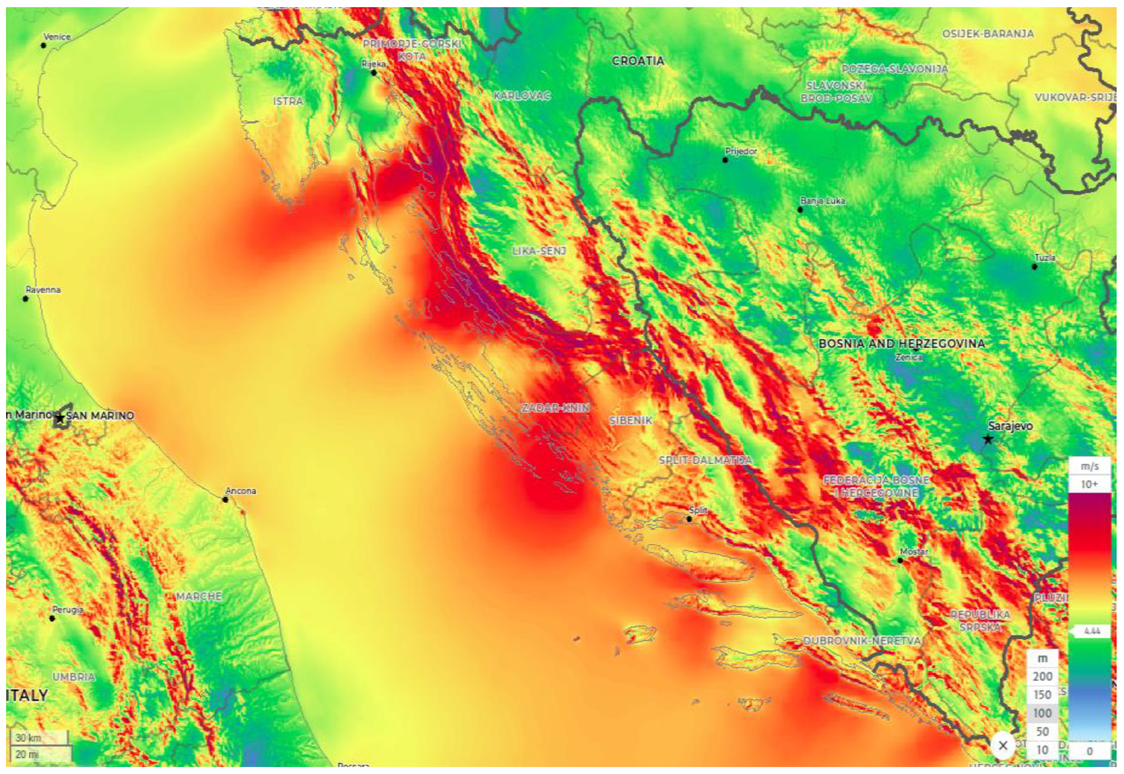
Wind speed is one of the most important (if not the most important) factors in OWF positioning. According to Liščić et al. [31], constant wind speed between 5 and 25 m/s is the best possible option for energy extraction. In several studies [32,45,46], the lowest suggested wind speed was 6 m/s, whereas in [47,48], the authors proposed an even lower speed limit of 4 m/s. Data for the mean annual wind speed (m/s) in the period from 1992 to 2001 in the Croatian part of the Adriatic Sea can be found in the Wind Atlas [49], along with the mean annual power density (W/m2). The wind data are presented for heights of 10 and 80 m above sea level. It is notable that the strongest wind speed zones are between Pula and the island of Mali Lošinj, in front of town Senj, at the open sea in front of town Šibenik, south of the islands of Hvar and Mljet and town of Dubrovnik. For example, the wind speed increases to 6.6 m/s in front of Šibenik and Mljet and up to 6.2 m/s in front of Pula. Likewise, Hvar has a slightly lower wind speed. The other source used for this research is the Global Wind Atlas (GWA) 3.0 [50]. GWA has the possibility of showing mean wind speeds at 10, 50, 100, 150 and 200 m above sea level. Because the height of OWT is 80–100 m, the GWA data for 100 m above sea level were further analyzed (Figure 1).
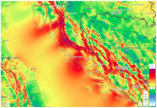
Figure 1.
Mean Wind Speed (m/s) at 100 m above the sea level (Source: GWA [50]).
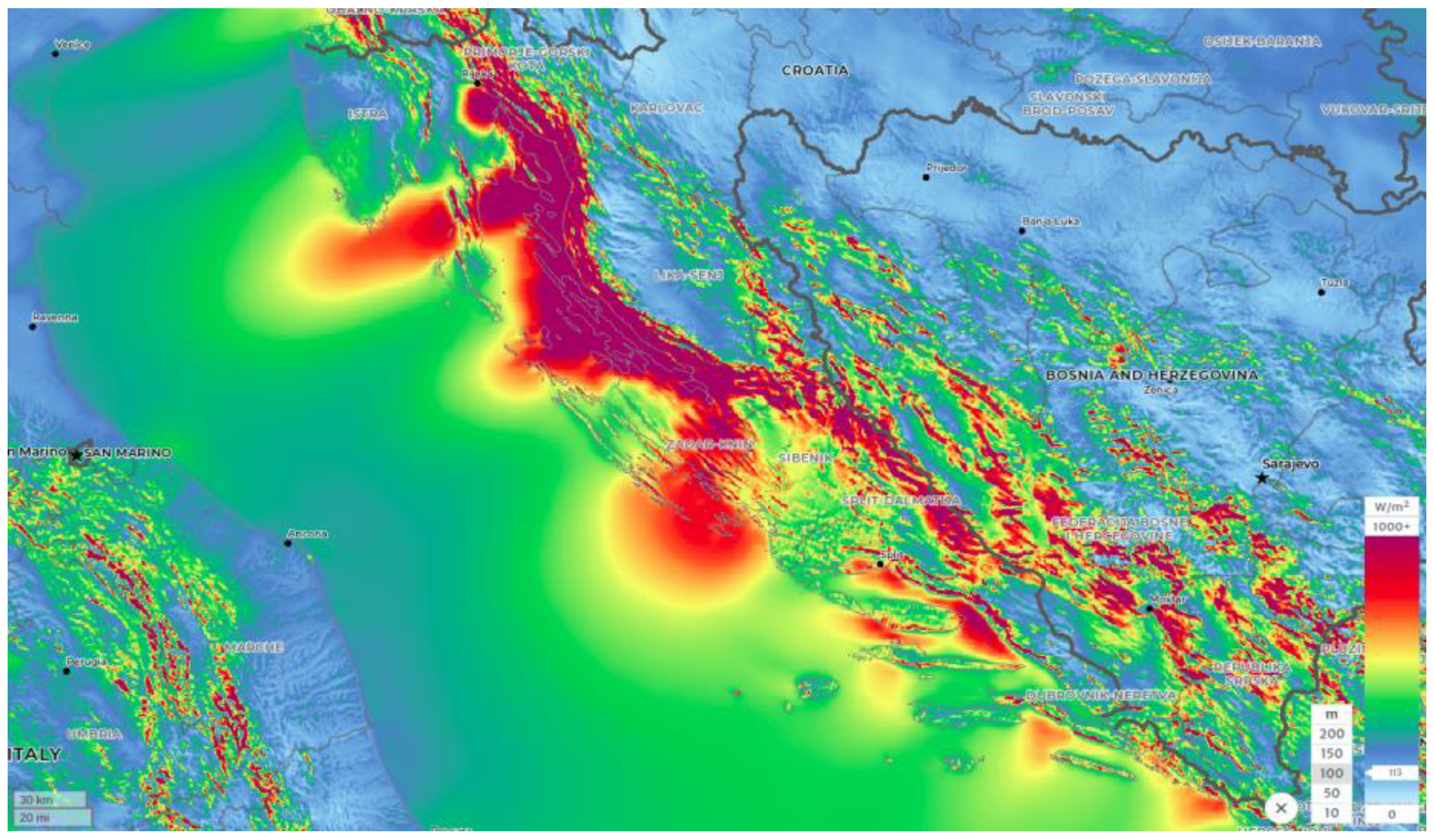
GWA shows a higher mean wind speed than [49], more than 10 m/s in the northern coastal areas and up to 8.5 m/s in the open sea zone. The mean annual power density reaches approximately 800 W/m2 in the northern coastal belt (Figure 2).
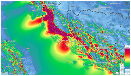
Figure 2.
Mean Power Density (W/m2) at 100 m above the sea level (Source: GWA [50]).
2.1.2. Water Depths
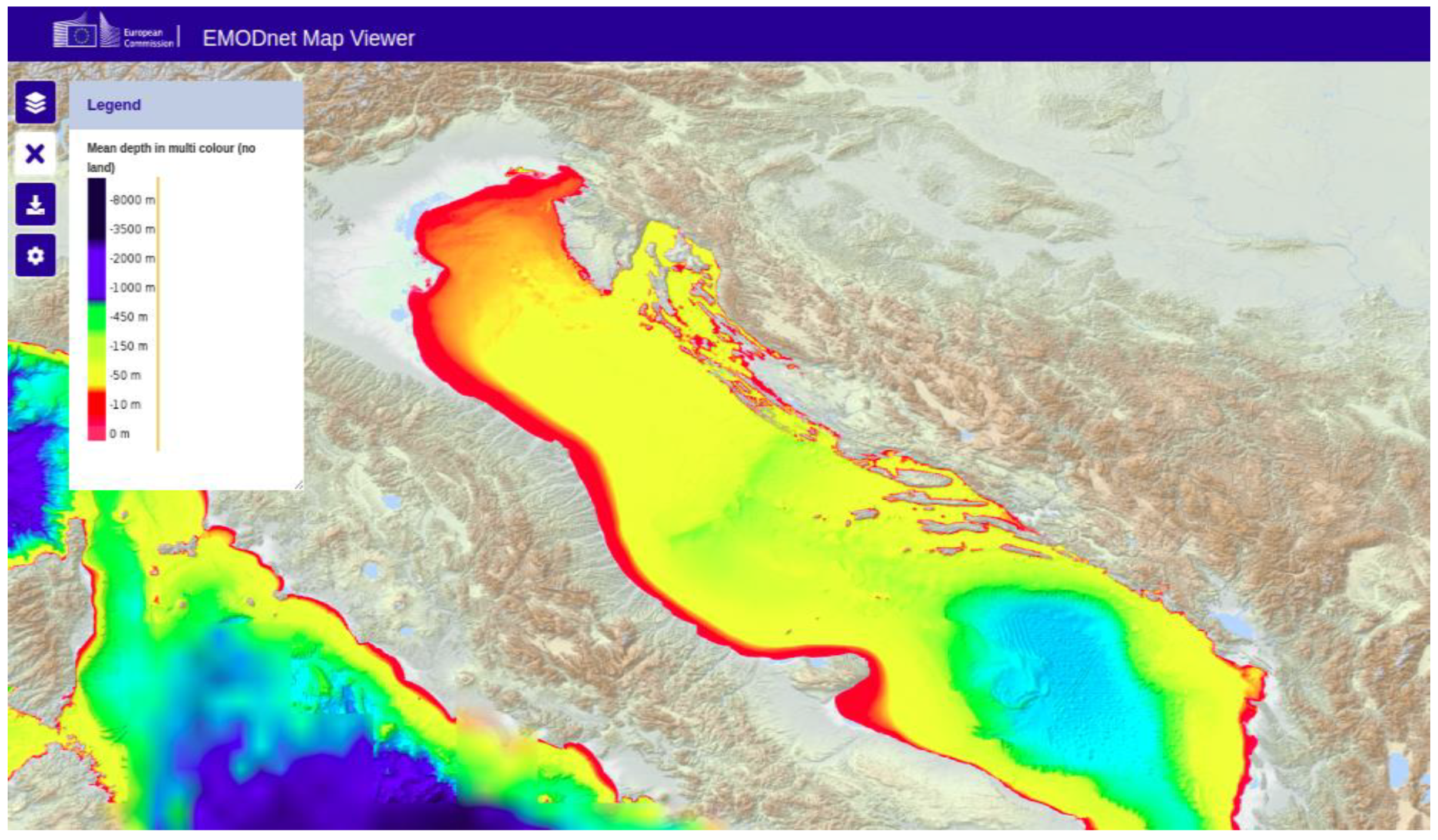
The Adriatic Sea is not very deep (Figure 3). The average depth is 173 m, and the deepest recorded point is 1233 m [26].
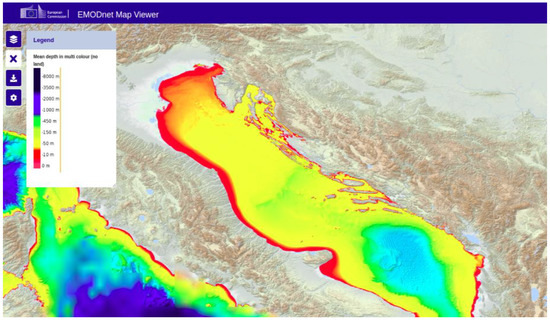
Figure 3.
Adriatic Sea depth shown in hypsometric scale of colours (Source: EMODnet [51]).
For instance, the maximum depths of the Mediterranean Sea, Tironian Sea and Ionian Sea are 5267 m, 3785 m, and 5267 m, respectively. The Adriatic Sea is 783 km long, with an average width of 248.3 km, and it covers 138.600 km2. In its east, the Croatian region has approximately 1300 islands and islets [26]. The northern part of the Adriatic Sea is very shallow, with depths up to 100 m due to the influence of the river Po. The middle part has depths of up to 500 m. The deepest part, with a maximum depth of 1233 m, is located in the Otranto Passage.
2.1.3. Seabed Sediment and Its Thickness
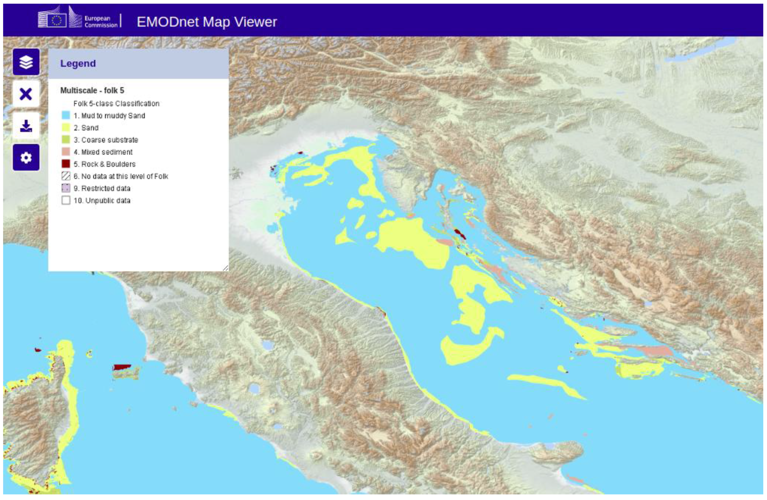
Marine sediments differ with respect to the depth of the Adriatic Sea. Consequently, at water depths higher than 100 m, the sediment is muddy, and in other parts, it is mostly sandy. [52] (Figure 4).
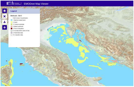
Figure 4.
Seabed substrate in the Adriatic Sea (Source: EMODnet [51]).
Both types of sediments are favourable for OWF installation. According to Straume et al. [53], the sediment thickness in the Adriatic Sea is approximately 3–4 km which makes it suitable for OWF installation.
2.1.4. Sea Borders and Legislation Frame
The Croatian part of the Adriatic Sea consists of inland waters, territorial sea and continental shelf. An act from 2021, with the name “Decision on the declaration of the Exclusive Economic Zone of the Republic of Croatia in the Adriatic Sea” [54], contains two new rights, the construction of artificial islands and the usage of the power of the sea, wind and currents in continental shelf.
The backbone for legislation of spatial planning in Croatia is the “Spatial Planning Act” [55]. Its Amendments [56] from the year 2017 enabled the full transfer of the MSP Directive into the legislative of the Republic of Croatia. Based on the act, drafting of the State Spatial Planning Plan for the entire land and sea area (up to the outer border of the territorial waters) of the Republic of Croatia has begun. Spatial plans for the protected terrestrial and marine areas have also been drawn up [57]. Amendments [56] defined Croatia’s cooperation with other EU member states in the area of MSP in the Adriatic Sea, cooperation with non-EU countries and the definition of competent authorities for SMEs. Important document for Croatian marine environment protection is “Regulation on the establishment of a framework for the activities of the Republic of Croatia in the protection of the marine environment” [58]. Based on the “Decision on the adoption of the Action Program of the Strategy for the Management of the Marine Environment and the Coastal Area: Monitoring and Observation System for the Constant Assessment of the State of the Adriatic Sea (2021–2026)” [44], the document “Action Program of Marine Environment and Coastal Area Management Strategy” [59] was established.
Looking at the technical aspect of OWFs placement possibilities, it was important to consult “Croatian Maritime law” [60] and its sub-act “Rulebook on the system of marking waterways and navigation safety facilities” [61], which refers to OWF markings for the purpose of safety of navigation at sea. It can be concluded, as determined from variety of sources, that Croatian legislation recognizes the possibility of OWF installation in the Croatian part of Adriatic Sea.
2.1.5. Exclusion Areas
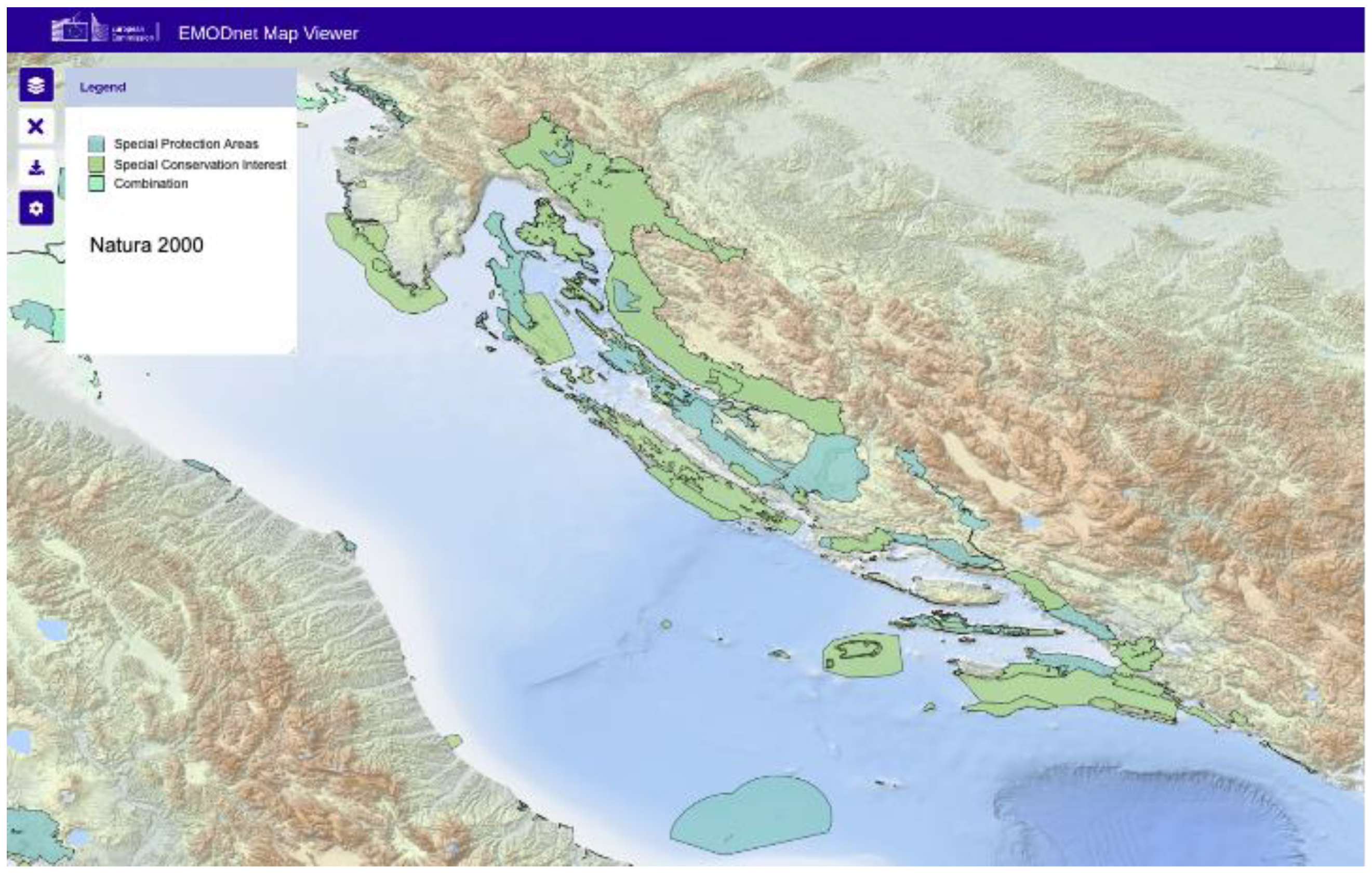
Several sea areas were excluded from the research due to submarine cables and pipelines being positioned. The rule of a restriction belt spreading 500 m on both sides of the cable or pipeline was followed to avoid possible damage. In the northern part of the Adriatic Sea, there are some navigation corridors that had to be avoided. Tourism is one of the main economic activities on the Croatian coast and islands; therefore, the rule of an OWF distance of at least 10 km from the islands and the coast had to be followed. The authors also considered the official data from the charts of the Hydrographic Institute of the Republic of Croatia regarding residual danger from explosive ordnance on the seabed. The Natura 2020 [62] network area (Figure 5) was respected and excluded, since MSP context needed to be followed, and the authors wished to avoid jeopardizing the environment.
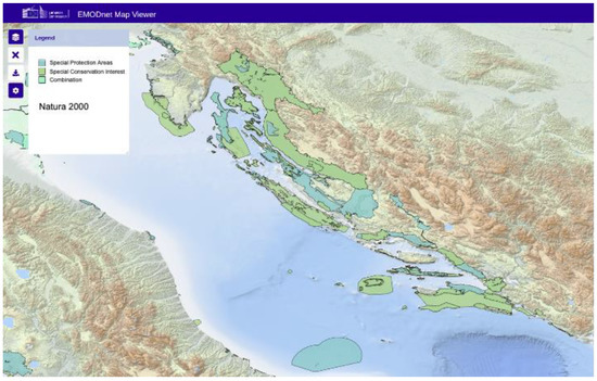
Figure 5.
Natura 2020 network area (in different shades of green) in the Adriatic Sea (Source: EMODnet [51]).
The Natura 2020 network covers EU countries at sea and on land, defining protected areas for different species. The aim is to ensure the survival of some of the most valuable species. It consists of special protection areas and conservation interests.
2.1.6. Vessel’s Density
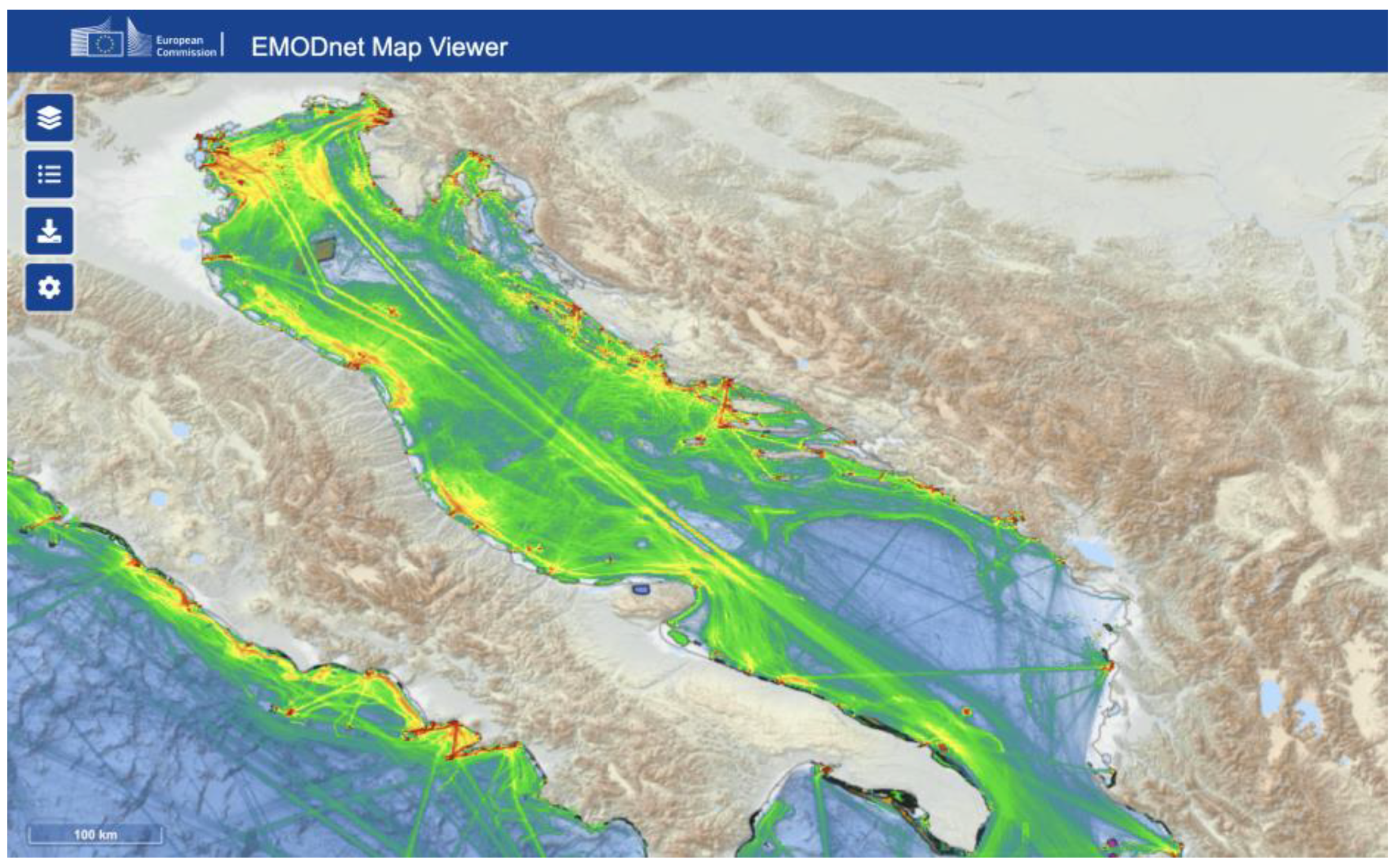
The vessel density was also taken into consideration, as shown in Table 1. Because of GNSS (Global Navigation Satellite System) technology, each vessel’s route can be traced. Blue colour shows fewer vessels, whereas green, yellow and red show more vessel density (Figure 6).

Table 1.
Suitability scores of selected criteria.
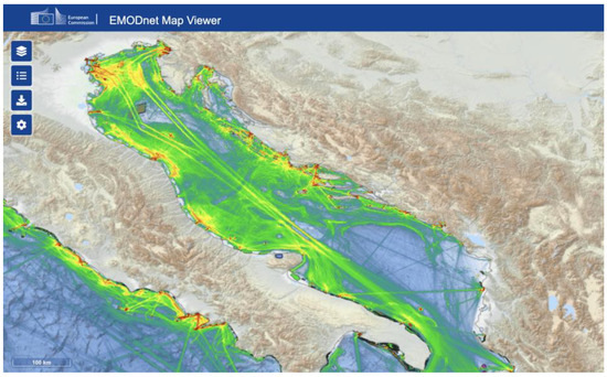
Figure 6.
Average vessel density (2017–2021) in the Adriatic Sea (Source: EMODnet [51]).
2.1.7. Electric Grid, Airports, Ports
The electric grid is an important factor in OWF positioning. The closer the network is, the cheaper the electricity production. In this study, the grid of 110 kV or higher was considered, as was its closeness to the points of interest. There are three main lines of 110 kV cables on the coast. The first one is laid along the coast and main towns on the coast, and the second one is set down connecting islands of Krk, Cres, Mali Lošinj and also Krk with Rab and Pag. The third one is laid along the islands of Brač, Hvar, Korčula and Pelješac and further towards Dubrovnik.
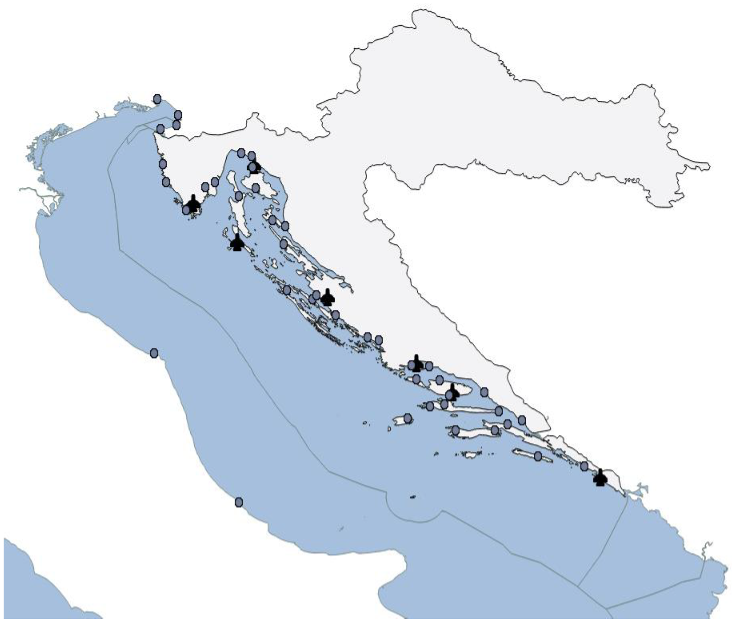
Moreover, the OWF should not be installed close to airports (symbol of the plane in Figure 7) or ports (symbol of the circle in Figure 7), thereby creating additional restriction zones (Table 1).
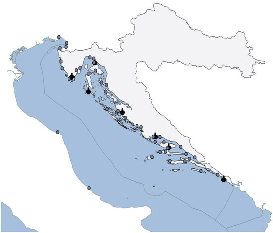
Figure 7.
Ports and airports (Source: Open Street Map [63]).
2.2. GIS, Fuzzy AHP and TOPSIS Analysis
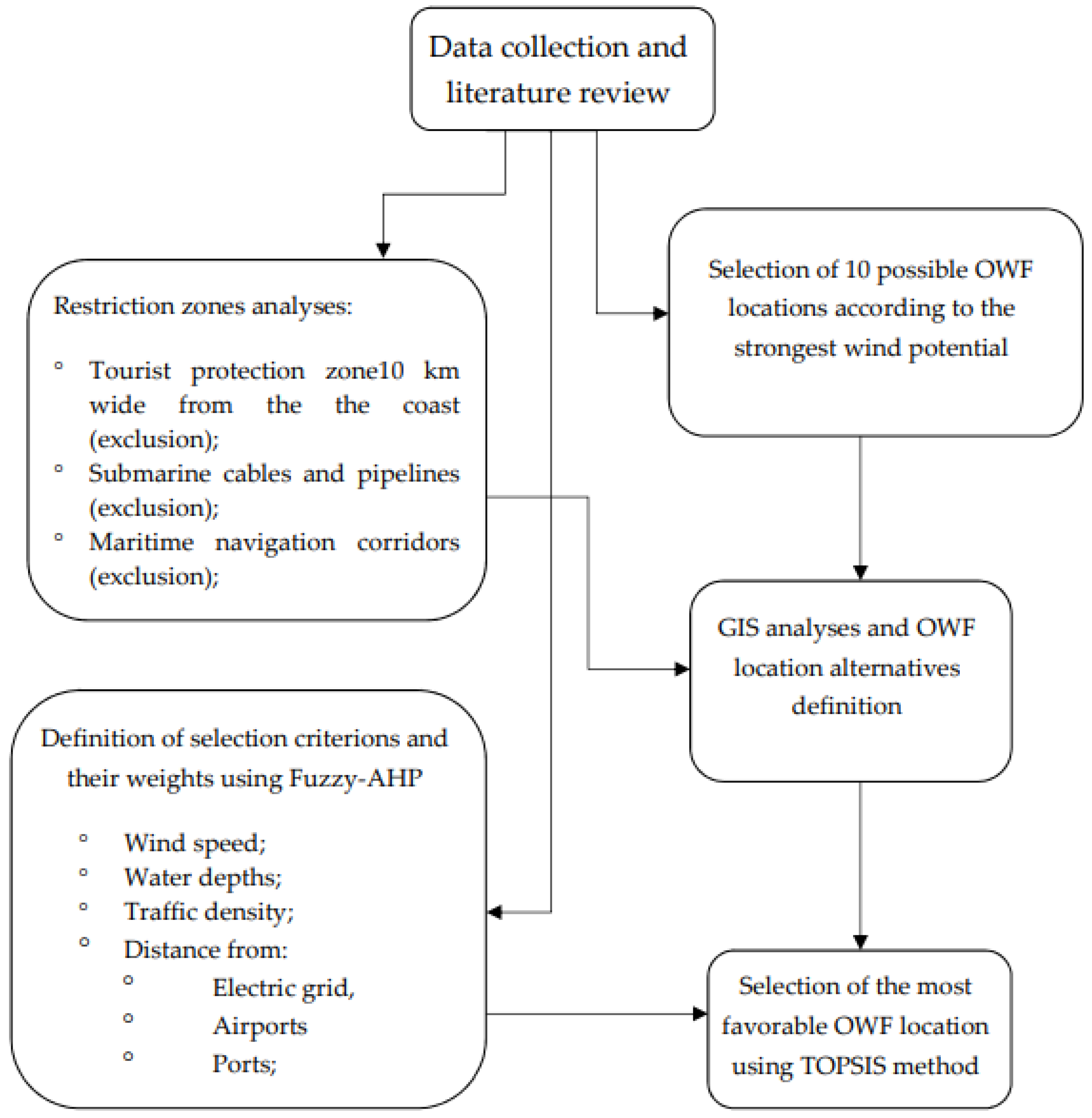
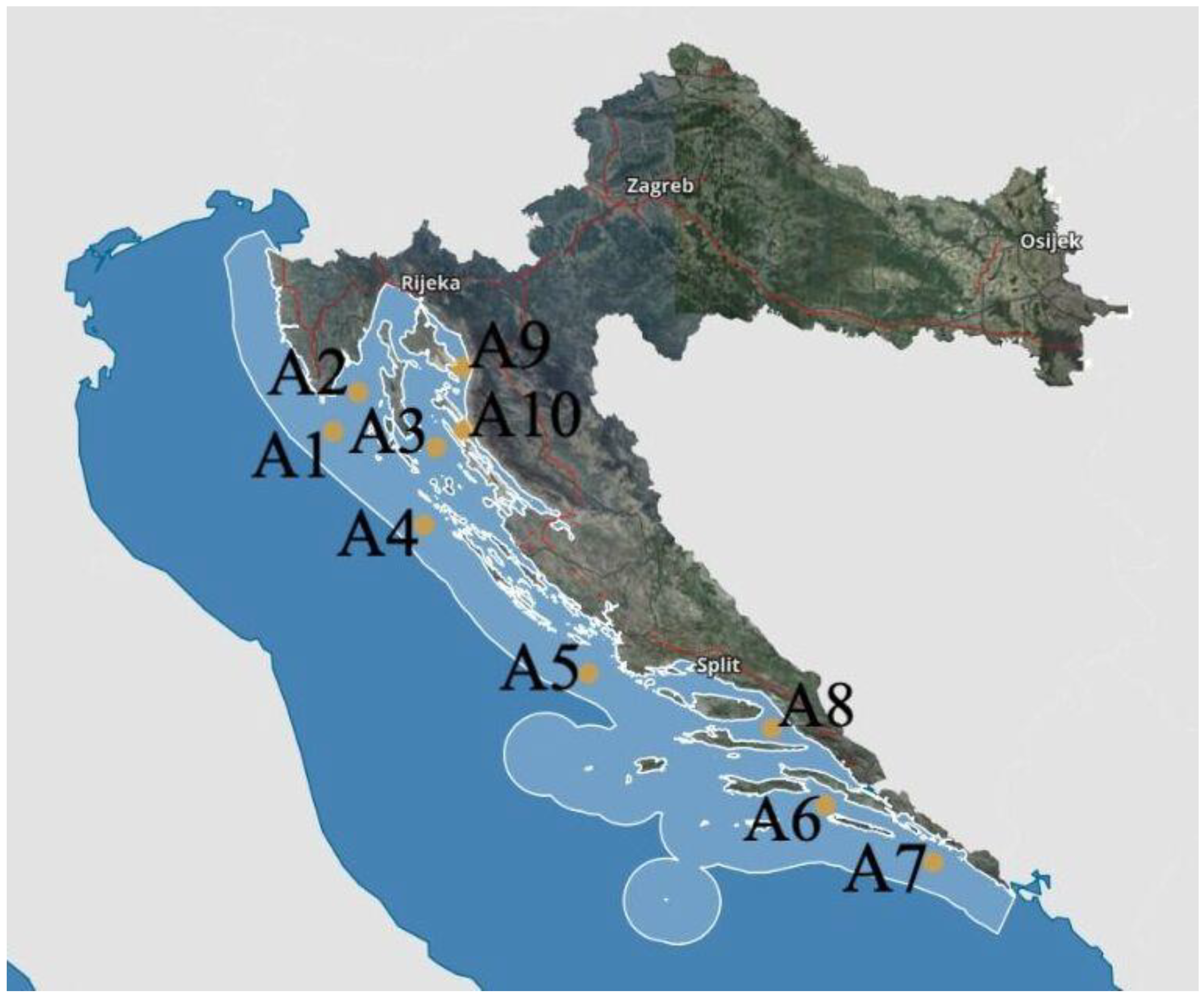
The procedure for selecting the most favourable offshore wind farms (OWF) locations is shown in Figure 8. Firstly, the analysis of possible OWF positions was performed based only on the wind speed on the east coast of the Adriatic Sea. Ten possible points were selected based on the mean wind speed input (Figure 9). The authors analyzed the mean wind speed, as shown in Figure 1, because it is the main issue to consider in OWF positioning. Ten points initially chosen had the strongest mean wind speed, according to [50]. Based on a literature review and features of the Croatian part of the Adriatic Sea, the exclusion and selection criteria were defined, and the fuzzy AHP methodology was used to define weights for each of the selected criteria. Several experts were consulted for the input parameters for the Fuzzy AHP analysis. GIS analysis was performed based on the exclusion criteria in the QGIS software (Version 3.30.1), and six initially proposed OWF positions were excluded. The TOPSIS analysis was used for the four remaining OWF position points in order to find the best positioning solution.
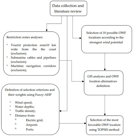
Figure 8.
Methodological diagram.
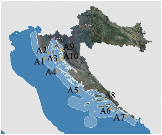
Figure 9.
Ten points initially chosen based on the wind speed.
The first group of criteria includes the following elimination criteria:
- Maritime navigation corridors;
- Submarine cables and pipelines;
- Sea borders;
- Natura 2000 *;
- Tourist protection zone.
* denotes a network of core breeding and resting sites for rare and threatened species.
In the areas covered by the above criteria, it is not possible to position OWF.
Other criteria by which it is necessary to determine weight values include the following:
- Water depth (C1);
- Wind speed (C2);
- Distance from ports (C3);
- Distance to airports (C4);
- Distance from power grid (C5);
- Traffic density (C6).
When all restrictions were considered, four major areas of possible OWF locations remained (A1, A4, A5 and A7 alternatives).
Subsequently, the weights for all six criteria were determined using the Fuzzy AHP method, and in the last stage of the calculation, the most favourable location of the potential OWF was calculated using the TOPSIS method.
The criteria and suitability scores for the selected criteria are listed in Table 1.
A pairwise comparison matrix was created to determine the weights of the individual criteria using the Fuzzy AHP method (Table 2).

Table 2.
Pairwise comparison matrix.
To determine the criteria weights, the decision maker for each pair of criteria (Ci, Cj) must estimate their relative and decide on one of the following statements:
- (a)
- Both criteria are equally important;
- (b)
- Criterion Ci is more important than Cj;
- (c)
- Criterion Cj is more important than Ci.
Choosing any of these statements entails the corresponding quantification of criteria weights ratio wi/wj as follows:
The comparison matrix above is then converted into triangular fuzzy numbers, and each grade is expanded with a lower and upper value, as shown in Table 3.

Table 3.
Pairwise comparison matrix, triangular fuzzy numbers.
For each criterion, it is necessary to create a separate matrix and then calculate the geometric mean for each row of the matrix (each criterion) according to Formula (1):
For example,
In addition, weights were calculated (as triangular fuzzy numbers—3 values) according to Formula (2), and the fuzzy weights of each criterion (Table 4) were defined by incorporating the next three sub-steps.

Table 4.
Weights as triangular fuzzy numbers.
- Define the vector summation of each ri;
- Find the (−1) power of the summation vector. Replace the fuzzy triangular number to make it in increasing order;
- Find the fuzzy weight of criterion i (wi), and multiply each ri with this reverse vector.
Because wi are still fuzzy triangular numbers, they need to be de-fuzzed; thus, the following matrix of weights (three values) is obtained, and the average value Mi—relation (3) is calculated from them; Mi is a non-fuzzy number; therefore, these values are normalized by following Equation (4). Table 5 shows the values of Ni, which represent the final weights of the criterion obtained by Fuzzy AHP.

Table 5.
Final criterion weights obtained by Fuzzy AHP.
In the final part of the study, the most favourable location for the OWF was calculated using the TOPSIS method. Moreover, this procedure involves several steps to obtain the most favourable alternative. The criterion values for each of the four potential locations/alternatives are listed in Table 6.

Table 6.
Criterion value/alternative.
Furthermore, it is necessary to calculate the normalized matrix (Table 7) and weighted normalized matrix (Table 8).

Table 7.
Normalization decision matrix.

Table 8.
Weighted normalized matrix (V).
The normalization is conducted based on the following Formula (5),
where Xij represents the value of the i-th alternative according to the j-th criterion, and n is the number of criteria.
The weighted normalized matrix (V) is calculated from relation (6).
Vij = xij × wj
The TOPSIS process is based on the fact that the solution to the problem is the alternative that is closest to the ideal one and furthest from the anti-ideal alternative (Table 9). The ideal alternative S+ contains the best values for each attribute, and the anti-ideal alternative S− contains the worst values for each attribute. The two created alternatives indicate the most preferable alternative (ideal solution) and the least preferable alternative (negative-ideal solution). It is also obvious that these alternatives do not exist in the offered set of alternatives. Namely, if S+ exists, the problem is solved, i.e., the perfect solution exists.

Table 9.
Ideal best and anti-ideal value based on TOPSIS calculation.
The calculation of the Euclidian distance from the best/anti-ideal value is shown in Formulas (7) and (8).
Vj+ and Vj− represent the best ideal end anti-ideal value.
The relative closeness to the ideal solution is then calculated from the Formula (9). Obviously, RCi = 1 if Si = S+ and RCi = 0 if Si = S−. An alternative is closer to the ideal solution and, therefore, better as RCi approaches 1.
The final ranking of the alternatives is presented in Table 10.

Table 10.
Alternatives ranking.
It can be seen that point A4 is the best possible option, followed by A1, A5 and A7.
3. Discussion and Conclusions
Three main questions were addressed in this paper. The first one was about the appropriate methodology for establishing OWF positioning. The scientific literature on trends in EU and non-EU countries in OWF positioning methodology was consulted for this purpose. Based on the research conducted, it was concluded that there is no single solution and no single answer to that question. The unique method does not exist, and there is no unique answer to the OWF position-establishing question. Good examples of GIS and MCMD methods combined in many EU and non-EU countries provided an answer to the question of what are the most used methods in OWF position establishment. Based on their experience and the experience of Croatian experts that were consulted, the methodology was established to answer the second question of the paper, that of the possibility of positioning an OWF in the Croatian part of the Adriatic Sea. The authors further consulted the available literature and established that no OWF was installed in the Adriatic Sea. The strong point of the research for OWF installation in Croatia was the cognition that there is legislation that supports this possibility. The legislation should be further developed, however, and its starting point is good and promising. The third question that required an answer was what would be the best possible location for installing an OWF in Croatia. For that purpose, a combination of GIS and fuzzy AHP methods was used. The suitability scores of the available selected criteria are listed in Table 1. The scores were based on the experience of the available literature and other countries’ practices. Ten points of interest were initially considered (A1–A10), chosen on a mean wind speed basis and measured during a ten-year period. Based on the exclusion parameters defined in subchapter 2.2.5, six points of interest were excluded. The coast of Croatia is well developed and has more than 1000 islands and strong tourist activity for at least half a year. This creates a potential problem in OWF positioning if the tourism criterion of following the rule of distancing OWF positioning at least 10 km from the coast and islands is respected. Four points of interest (A1, A4, A5 and A7) were left for consideration. The best possible point (A4) was determined using the TOPSIS methodology.
The findings of this study should be considered as a starting point for further and more detailed analysis of OWF installation. They should also raise the topic of OWFs’ stronger consideration in Croatia in the MSP context, as defined within EU regulations. Further research should address the economic value and technical aspects of OWF in the Adriatic Sea. A combination of wind and wave energy usage at sea should be considered together with the possibility of required construction built in Croatian shipyards, as mentioned in the paper by Klarin [29]. The authors of this paper emphasize that experts in different technical fields should, in their future research, consider ecological segments that are equally important for OWF and similar topics. However, this was not the case in Croatia. Future studies could consider more inputs than those chosen in Table 1 and methods other than those used in this paper, but the MSP context should always be included. The authors believe that there is a good perspective for raising sustainable energy usage in Croatia and that the positive trends established on Croatian land will extend themselves to the Croatian part of the Adriatic Sea as well.
Author Contributions
Conceptualization, I.R. and N.O.Š.; methodology, I.R.; software, M.P. and N.O.Š.; validation, I.R., M.Z. and N.O.Š.; formal analysis, I.R. and M.P.; investigation, I.R., M.P. and N.O.Š.; resources, I.R., M.P. and N.O.Š.; data curation, M.Z.; writing—original draft preparation, I.R., M.P. and N.O.Š.; writing—review and editing, I.R., M.P., N.O.Š. and M.Z.; visualization, M.P.; supervision, I.R., N.O.Š. and M.Z. All authors have read and agreed to the published version of the manuscript.
Funding
This research received no external funding.
Acknowledgments
This research is partially supported through project KK.01.1.1.02.0027, a project co-financed by the Croatian Government and the European Union through the European Regional Development Fund—the Competitiveness and Cohesion Operational Programme.
Conflicts of Interest
The authors declare no conflict of interest.
References
- EUROSTAT. Share of Renewable Energy More than Doubled between 2004 and 2021. Available online: https://ec.europa.eu/eurostat/statistics-explained/index.php?title=Renewable_energy_statistics#Share_of_renewable_energy_more_than_doubled_between_2004_and_2021 (accessed on 1 March 2023).
- EUROSTAT. Wind and Water Provide Most Renewable Electricity; Solar Is the Fastest-Growing Energy Source. Available online: https://ec.europa.eu/eurostat/statistics-explained/index.php?title=Renewable_energy_statistics#Wind_and_water_provide_most_renewable_electricity.3B_solar_is_the_fastest-growing_energy_source (accessed on 1 March 2023).
- Chen, C.-H.; Su, N.-J. Global Trends and Characteristics of Offshore Wind Farm Research over the Past Three Decades: A Bibliometric Analysis. J. Mar. Sci. Eng. 2022, 10, 1339. [Google Scholar] [CrossRef]
- Ramsay, W.; Goupee, A.; Allen, C.; Viselli, A.; Kimball, R. Optimization of a Lightweight Floating Offshore Wind Turbine with Water Ballast Motion Mitigation Technology. Wind 2022, 2, 535–570. [Google Scholar] [CrossRef]
- Xu, S.; Xue, Y.; Zhao, W.; Wan, D. A Review of High-Fidelity Computational Fluid Dynamics for Floating Offshore Wind Turbines. J. Mar. Sci. Eng. 2022, 10, 1357. [Google Scholar] [CrossRef]
- Altuzarra, J.; Herrera, A.; Matías, O.; Urbano, J.; Romero, C.; Wang, S.; Guedes Soares, C. Mooring System Transport and Installation Logistics for a Floating Offshore Wind Farm in Lannion, France. J. Mar. Sci. Eng. 2022, 10, 1354. [Google Scholar] [CrossRef]
- Belvasi, N.; Judge, F.; Murphy, J.; Desmond, C. Analysis of Floating Offshore Wind Platform Hydrodynamics Using Underwater SPIV: A Review. Energies 2022, 15, 4641. [Google Scholar] [CrossRef]
- Fan, Q.; Wang, X.; Yuan, J.; Liu, X.; Hu, H.; Lin, P. A Review of the Development of Key Technologies for Offshore Wind Power in China. J. Mar. Sci. Eng. 2022, 10, 929. [Google Scholar] [CrossRef]
- Guo, X.; Zhang, Y.; Yan, J.; Zhou, Y.; Yan, S.; Shi, W.; Li, X. Integrated Dynamics Response Analysis for IEA 10-MW Spar Floating Offshore Wind Turbine. J. Mar. Sci. Eng. 2022, 10, 542. [Google Scholar] [CrossRef]
- Alsubal, S.; Liew, M.S.; Shawn, L.E. Preliminary Design and Dynamic Response of Multi-Purpose Floating Offshore Wind Turbine Platform: Part 1. J. Mar. Sci. Eng. 2022, 10, 336. [Google Scholar] [CrossRef]
- Amiri, N.; Shaterabadi, M.; Reza Kashyzadeh, K.; Chizari, M. A Comprehensive Review on Design, Monitoring, and Failure in Fixed Offshore Platforms. J. Mar. Sci. Eng. 2021, 9, 1349. [Google Scholar] [CrossRef]
- Gao, S.; Zhang, L.; Shi, W.; Wang, B.; Li, X. Dynamic Responses for WindFloat Floating Offshore Wind Turbine at Intermediate Water Depth Based on Local Conditions in China. J. Mar. Sci. Eng. 2021, 9, 1093. [Google Scholar] [CrossRef]
- Basbas, H.; Liu, Y.-C.; Laghrouche, S.; Hilairet, M.; Plestan, F. Review on Floating Offshore Wind Turbine Models for Nonlinear Control Design. Energies 2022, 15, 5477. [Google Scholar] [CrossRef]
- Ghigo, A.; Cottura, L.; Caradonna, R.; Bracco, G.; Mattiazzo, G. Platform Optimization and Cost Analysis in a Floating Offshore Wind Farm. J. Mar. Sci. Eng. 2020, 8, 835. [Google Scholar] [CrossRef]
- Díaz, H.; Serna, J.; Nieto, J.; Guedes Soares, C. Market Needs, Opportunities and Barriers for the Floating Wind Industry. J. Mar. Sci. Eng. 2022, 10, 934. [Google Scholar] [CrossRef]
- Cordal-Iglesias, D.; Filgueira-Vizoso, A.; Baita-Saavedra, E.; Graña-López, M.Á.; Castro-Santos, L. Framework for Development of an Economic Analysis Tool for Floating Concrete Offshore Wind Platforms. J. Mar. Sci. Eng. 2020, 8, 958. [Google Scholar] [CrossRef]
- Filgueira-Vizoso, A.; Castro-Santos, L.; Iglesias, D.C.; Puime-Guillén, F.; Lamas-Galdo, I.; García-Diez, A.I.; Uzunoglu, E.; Díaz, H.; Guedes Soares, C. The Technical and Economic Feasibility of the CENTEC Floating Offshore Wind Platform. J. Mar. Sci. Eng. 2022, 10, 1344. [Google Scholar] [CrossRef]
- Li, H.; Guedes Soares, C. Assessment of failure rates and reliability of floating offshore wind turbines. Reliab. Eng. Syst. Saf. 2022, 228, 108777. [Google Scholar] [CrossRef]
- Myhr, A.; Bjerkseter, C.; Ågotnes, A.; Nygaard, T.A. Levelised cost of energy for offshore floating wind turbines in a life cycle perspective. Renew. Energy 2014, 66, 714–728. [Google Scholar] [CrossRef]
- Li, J.; Shi, W.; Zhang, L.; Michailides, C.; Li, X. Wind–Wave Coupling Effect on the Dynamic Response of a Combined Wind–Wave Energy Converter. J. Mar. Sci. Eng. 2021, 9, 1101. [Google Scholar] [CrossRef]
- Fenu, B.; Attanasio, V.; Casalone, P.; Novo, R.; Cervelli, G.; Bonfanti, M.; Sirigu, S.A.; Bracco, G.; Mattiazzo, G. Analysis of a Gyroscopic-Stabilized Floating Offshore Hybrid Wind-Wave Platform. J. Mar. Sci. Eng. 2020, 8, 439. [Google Scholar] [CrossRef]
- Farkas, A.; Degiuli, N.; Martić, I. Assessment of Offshore Wave Energy Potential in the Croatian Part of the Adriatic Sea and Comparison with Wind Energy Potential. Energies 2019, 12, 2357. [Google Scholar] [CrossRef]
- Wang, Z.; Guo, Y.; Wang, H. Review on Monitoring and Operation-Maintenance Technology of Far-Reaching Sea Smart Wind Farms. J. Mar. Sci. Eng. 2022, 10, 820. [Google Scholar] [CrossRef]
- European Parliament. Available online: https://www.eea.europa.eu/policy-documents/directive-2014-89-eu-maritime (accessed on 27 February 2023).
- WindEurope. Available online: https://windeurope.org/intelligence-platform/product/european-offshore-wind-farms-map-public/ (accessed on 16 January 2023).
- Croatian Encyclopedia, Leksikografski Zavod Miroslav Krleža. Adriatic Sea. Available online: https://www.enciklopedija.hr/Natuknica.aspx?ID=28478 (accessed on 23 November 2022).
- Frančula, N.; Lapaine, M. Površina hrvatskoga mora. Hrvat. Rev. 2001, 51, 107–111. [Google Scholar]
- The European Maritime Spatial Planning Platform. Available online: https://maritime-spatial-planning.ec.europa.eu/countries/croatia (accessed on 27 October 2022).
- Klarin, B. Energetski otoci—Hibridni pučinski objekti. Pomor. Zb. 2016, Special edition, 187–200. [Google Scholar] [CrossRef]
- Hadžić, N.; Čatipović, I.; Tomić, M.; Vladimir, N.; Kozmar, H. Offshore Wind Turbines—Research and Development. Pomor. Zb. 2018, Special edition, 59–70. [Google Scholar] [CrossRef]
- Liščić, B.; Senjanović, I.; Čorić, V.; Kozmar, H.; Tomić, M.; Hadžić, N. Offshore Wind Power Plant in the Adriatic Sea: An Opportunity for the Croatian Economy. Trans. Marit. Sci. 2014, 3, 103–110. [Google Scholar] [CrossRef]
- Vagiona, D.G.; Kamilakis, M. Sustainable Site Selection for Offshore Wind Farms in the South Aegean—Greece. Sustainability 2018, 10, 749. [Google Scholar] [CrossRef]
- Vagiona, D.G.; Karanikolas, N.M. A multicriteria approach to evaluate offshore wind farms siting in Greece. Glob. NEST J. 2012, 14, 235–243. [Google Scholar]
- Chaouachib, A.; Covriga, C.F.; Ardeleana, M. Multi-criteria selection of offshore wind farms: Case study for the Baltic States. Energy Policy 2017, 103, 179–192. [Google Scholar] [CrossRef]
- Ziemba, P. Multi-Criteria Fuzzy Evaluation of the Planned Offshore Wind Farm Investments in Poland. Energies 2021, 14, 978. [Google Scholar] [CrossRef]
- Cradden, L.; Kalogeri, C.; Martinez Barrios, I.; Galanis, G.; Ingram, D.; Kallos, G. Multi-criteria site selection for offshore renewable energy platforms. Renew. Energy 2016, 87, 791–806. [Google Scholar] [CrossRef]
- Wu, Y.; Tao, Y.; Zhang, B.; Wang, S.; Xu, C.; Zhou, J. A decision framework of offshore wind power station site selection using a PROMETHEE method under intuitionistic fuzzy environment: A case in China. Ocean. Coast. Manag. 2020, 184, 105016. [Google Scholar] [CrossRef]
- Mayaki, E.A.; Adedipe, O.; Lawal, S.A. Multi-Criteria Evaluation of the Appropriate Offshore Wind Farm Location in Nigeria. IOP Conf. Ser. Mater. Sci. Eng. 2018, 413, 012041. [Google Scholar] [CrossRef]
- Taoufik, M.; Fekri, A. GIS-based multi-criteria analysis of offshore wind farm development in Morocco. Energy Convers. Manag. X 2021, 11, 100103. [Google Scholar] [CrossRef]
- Mahdy, M.; Bahaj, A.S. Multi criteria decision analysis for offshore wind energy potential in Egypt. Renew. Energy 2018, 118, 278–289. [Google Scholar] [CrossRef]
- Pereira de Azevedo, S.S.; Pereira Junior, A.O.; Fidelis da Silva, N.; Barbosa de Araújo, R.S.; Carlos Júnior, A.A. Assessment of Offshore Wind Power Potential along the Brazilian Coast. Energies 2020, 13, 2557. [Google Scholar] [CrossRef]
- Ilbahara, E.; Cebia, S.; Kahramanb, C. A state-of-the-art review on multi-attribute renewable energy decision making. Energy Strategy Rev. 2019, 25, 18–33. [Google Scholar] [CrossRef]
- Tasri, A.; Susilawati, A. Selection among renewable energy alternatives based on a fuzzy analytic hierarchy process in Indonesia. Sustain. Energy Technol. Assess. 2014, 7, 34–44. [Google Scholar] [CrossRef]
- Ministry of Economy and Sustainable Development of the Republic of Croatia. Action Program of Marine Environment and Coastal Area Management Strategy. Available online: https://mingor.gov.hr/UserDocsImages/Uprava_vodnoga_gospodarstva_i_zast_mora/Strategija_upravljanja_morem/Akcijski%20program%20Sustav%20pra%C4%87enja%202021_2026.pdf (accessed on 20 January 2023).
- Sourianos, E.; Kyriakou, K.; Hatiris, G.A. GIS-based spatial decision support system for the optimum siting of offshore windfarms. Eur. Water 2017, 58, 337–343. [Google Scholar]
- Schallenberg-Rodríguez, J.; García Montesdeoca, N. Spatial planning to estimate the offshore wind energy potential in coastal regions and islands. Practical case: The Canary Islands. Energy 2018, 143, 91–103. [Google Scholar] [CrossRef]
- Gavériaux, L.; Laverrière, G.; Wang, T.; Maslov, N.; Claramunt, C. GIS-based multicriteria analysis for offshore wind turbine deployment in Hong Kong. Ann. GIS 2019, 25, 207–218. [Google Scholar] [CrossRef]
- Díaz, H.; Fonseca, R.B.; Guedes Soares, C. Site selection process for floating offshore wind farms in Madeira Islands. In Advances in Renewable Energies Offshore; Taylor & Francis Group: London, UK, 2019; pp. 729–737. [Google Scholar]
- Croatian Meteorological and Hydrological Service. Wind Atlas. Available online: https://meteo.hr/klima_e.php?section=klima_hrvatska¶m=k1_8 (accessed on 2 November 2022).
- Global Wind Atlas (GWA). Available online: https://globalwindatlas.info/en (accessed on 3 November 2022).
- EMODnet. Available online: https://emodnet.ec.europa.eu/en (accessed on 11 December 2022).
- Schwartz, M.L. (Ed.) Encyclopedia of Coastal Science; Encyclopedia of Earth Sciences; Springer: Amsterdam, The Netherlands, 2005; Volume 24. [Google Scholar]
- Straume, E.O.; Gaina, C.; Medvedev, S.; Hochmuth, K.; Gohl, K.; Whittaker, J.M.; Abdul Fattah, R.; Doornenbal, J.C.; Hopper, J.R. GlobSed: Updated total sediment thickness in the world’s oceans. Geochem. Geophys. Geosyst. 2019, 20, 1756–1772. [Google Scholar] [CrossRef]
- Official Gazette 10/21. Available online: https://narodne-novine.nn.hr/clanci/sluzbeni/2021_02_10_192.html (accessed on 7 January 2023).
- Official Gazette 153/13. Available online: https://narodne-novine.nn.hr/clanci/sluzbeni/2013_12_153_3220.html (accessed on 17 January 2023).
- Official Gazette 65/17. Available online: https://narodne-novine.nn.hr/clanci/sluzbeni/2017_07_65_1494.html (accessed on 17 January 2023).
- Kilić Pamuković, J.; Rogulj, K.; Racetin, I.; Vrdoljak, L. Prostorno planiranje na moru. In Proceedings of the 15th Symposium of Chartered Geodetic Engineers, Opatija, Croatia, 12–15 October 2022; Racetin, I., Zrinjski, M., Župan, R., Eds.; Croatian Chamber of Chartered Geodetic Engineers: Zagreb, Croatia, 2022; pp. 161–166. [Google Scholar]
- Official Gazette 136/11. Available online: https://narodne-novine.nn.hr/clanci/sluzbeni/2011_11_136_2724.html (accessed on 19 January 2023).
- Official Gazette 28/21. Available online: https://narodne-novine.nn.hr/clanci/sluzbeni/full/2021_03_28_602.html (accessed on 21 January 2023).
- Official Gazette 17/94. Available online: https://narodne-novine.nn.hr/clanci/sluzbeni/1994_03_17_313.html (accessed on 20 December 2022).
- Official Gazette 39/20. Available online: https://narodne-novine.nn.hr/clanci/sluzbeni/2020_04_39_830.html (accessed on 20 December 2022).
- Natura 2020. Available online: https://ec.europa.eu/environment/nature/natura2000/index_en.htm (accessed on 2 March 2023).
- Open Street Map. Available online: https://www.openstreetmap.org/ (accessed on 9 January 2023).
Disclaimer/Publisher’s Note: The statements, opinions and data contained in all publications are solely those of the individual author(s) and contributor(s) and not of MDPI and/or the editor(s). MDPI and/or the editor(s) disclaim responsibility for any injury to people or property resulting from any ideas, methods, instructions or products referred to in the content. |
© 2023 by the authors. Licensee MDPI, Basel, Switzerland. This article is an open access article distributed under the terms and conditions of the Creative Commons Attribution (CC BY) license (https://creativecommons.org/licenses/by/4.0/).

