Article

Auditing and Rating Sustainability of Mediterranean Buildings, Neighbourhoods and Cities

1
Group Energy Conservation, Institute for Environmental Research and Sustainable Development (IERSD), National Observatory of Athens (NOA), P. Penteli, 15236 Athens, Greece
2
iiSBE Italia R&D, International Initiative for a Sustainable Built Environment, 10138 Torino, Italy
*
Author to whom correspondence should be addressed.
Energies 2024, 17(1), 82; https://doi.org/10.3390/en17010082
Submission received: 29 November 2023 / Revised: 18 December 2023 / Accepted: 21 December 2023 / Published: 22 December 2023

Abstract

:
Sustainability rating systems for the built environment involve a multitude of indicators that are based on different types of data. This work capitalizes on an existing multicriteria assessment method and supporting decision-making tool at building and neighbourhood scale, to develop an enhanced method and tool at city scale. The main sustainability issues at building and city scales include site and infrastructure, energy and resources consumption, environmental loadings, climate change, environmental quality, water, waste, transportation, services, social aspects, economy and governance. Approximately 300 indicators distributed among the different scales are used to describe and quantify the various facets of sustainability. Specifically, the building scale includes a pool of 80 indicators of which 17 are key performance indicators (KPIs), the neighbourhood scale has 133 indicators of which 14 are KPIs and the city scale has a total of 99 indicators of which 10 are KPIs that were new additions to the existing method. The emphasis in this paper is given on elaborating the key performance indicators for cities and demonstrating their applicability through a case study. The common method and tools provide a flexible assessment system for local authorities and stakeholders to develop and assess sustainability plans.

1. Introduction

Buildings in the European Union (EU-27) used about 391 million tons of oil equivalent (Mtoe) (Figure 1) that represented 44% of the total final energy consumption in 2021 [1]. Adjusting the available data to compare with Europe 2020 targets and progress towards Europe 2030 energy efficiency targets, the temporary achievement of the −20% efficiency target in 2020 (Figure 1) was mainly the result of the widespread lockdowns and slowdown of the European economy during the COVID-19 pandemic. The energy use of the buildings sector in 2021 increased by 5.9% compared to 2020, while the rebound in the residential sector reached 5.5% and in the services sector climbed by 6.7%. Looking at the big picture (Figure 1), since 1990 the total energy use in the buildings sector exhibits small fluctuations and currently exceeds the 1990 value by 14%. Compared with the Europe 2030 target, there is currently a gap compared to the projected linear trajectory (Figure 1). Apparently, there will be a need for even more aggressive measures to lower the energy consumption and meet the proposed lower limit of the European climate law for reducing the EU emissions by 2030 by at least 55% compared to 1990 levels [2].
Cities collectively consume most resources and contribute to many environmental challenges including energy use and emissions from buildings and transport since they use about 78% of the world’s energy and produce over 60% of the global greenhouse gas (GHG) emissions [3]. As a result, cities and the built environment are a major part of the problem, but at the same time they can become part of the solution. Accordingly, cities and local governments should lead the effort towards a low carbon, resource-efficient, sustainable and resilient society. They have the potential to deliver on net-zero targets with specific city-level actions, but first they need to overcome various challenges [4].
Urbanization in Europe is increasing as more people live and work in cities, as about 70% of Europeans are currently living in urban areas [5]. Total GHG emissions in EU-27 reached 3541 kgCO2-eq in 2021 [1] including direct (on-site combustion) and indirect (from electricity use) operational emissions from the buildings sector. The variations in GHG emissions (Figure 2) exhibit a clear downward trend and currently are at about −28% below the 1990 value, well below the Europe 2020 target. Although the anticipated rebound of emissions as of 2022 (due to the war in Ukraine and the EU energy embargo on Russia that mandated the reactivation of coal-fired power plants) is not yet quantified, it appears that the overall trend may be under the −55% projected linear trajectory towards the Europe 2030 target.
European cities use about 60% to 80% of the final energy and collectively account for about two-thirds of the total GHG emissions [6]. Recognizing the pivotal role of urban environments on climate mitigation, 377 cities from all EU-27 member states, associated and neighbouring countries have engaged in the EU Mission that aims to deliver 100 climate-neutral and smart cities by 2030 [7]. Furthermore, initiatives like the Green City Accord [8] and awards like the Green Capital and Green Leaf [9] encourage cities to address environmental challenges and showcase their environmental performance.
Along these lines, the European strategy for a sustainable built environment [10] encompasses various approaches to address its various characteristics related to climate, energy, resources, circularity, materials, waste, accessibility and digitalisation, among others. As a result, the effort to address sustainability issues in the urban environment can be rather demanding, involving complex processes that may discourage decision makers, city officials and other stakeholders to engage. To support these efforts, several methods and tools have emerged that facilitate the audit phase to collect the necessary collection in order to calculate the parameters that support the decision-making process and monitor progress towards sustainability development goals [11]. However, there is no common language to facilitate the exchange of information among the different systems and their use in practice.

1.1. Sustainability

Sustainability is an all-inclusive term for a plethora of different issues that as a result makes it more difficult to address different initiatives and increases the complexity of efforts to address them. In this direction, public and commercial systems exploit similar methods that utilize different indicators to quantify various sustainability issues and criteria [12]. Among them are a manageable number of key performance indicators (KPI) that are selected and used to represent the common denominator for sustainability assessment. Each KPI is calculated following a common standardized procedure to facilitate cross-border comparisons.

1.2. Aim of This Work

The work evolved from available knowledge on the sustainability assessment of buildings and neighbourhoods [13] that was expanded to the city scale. This provides Mediterranean municipalities with a well-structured system that can be used to develop effective policies, strategies and action plans in line with the Mediterranean Strategy for Sustainable Development [14].
The current work capitalized on the CESBA MED method and tool [13] to provide a common language for exchanging information among different systems and tools for sustainability assessment. Specifically, the work enhanced the KPIs for building and neighbourhood scales and elaborated a new set of KPIs for the new city-scale assessment tool. The method and KPIs are supported with enhanced and multilingual educational and training material. The material was adapted to a national context developing three new national versions of the method and tools that were also validated during three city pilots around the south-east Mediterranean basin.
The emphasis in this paper is on the new KPIs for the city scale and the additions to the building scale beyond the ones in the existing system [12]. The KPIs of the city scale address issues like use of land and biodiversity, energy, water, waste, environmental quality, transportation and mobility, and climate change. The new KPIs on the building scale include among others the smart readiness indicator and embodied carbon. Finally, the paper concludes with an example from a short case study to demonstrate the applicability and elaboration of the KPIs.
The paper is structured as follows: Section 2 sets the stage providing some background information on the structure of the SMC Method and the existing method, touches on its operational characteristics with regard to the normalization and scoring process, and provides other supporting material and documentation. Section 3 elaborates the KPIs for the three assessment scales with an emphasis on the new contributions. The results from the case studies are briefly elaborated in Section 4, while Section 5 concludes by summarizing the main results.

2. The Sustainable Med Cities—SMC Method

The SMC Method capitalized on existing knowledge for measuring and rating the sustainability performance of Mediterranean buildings and neighbourhoods [12]. It advanced the work by introducing some new elements with the definition of additional KPIs and by expanding the application to city scale. The three assessment systems for the building, neighbourhood and city scales have a common structure that is built on:
  • Issues that describe general themes, important for sustainability assessment;
  • Categories that address specific aspects of issues;
  • Indicators that quantify or qualify the main assessment entries used to characterize a building, an urban area or city.
The SMC assessment system includes eight sustainability issues for the building scale and ten issues for the neighbourhood and city scales (Table 1). Similar issues may be encountered across different scales, although they are quantified with different indicators. For example, at building scale, the KPI for energy consumption is quantified by the energy use intensity for the different forms of energy, as the delivered electrical energy consumption per internal useful floor area per year (kWh/m2/yr). At city scale, energy consumption is quantified by the total final energy consumed by a city divided by the total population of the city per year (MWh/inhabitant/year). Beyond the KPIs, users can select and use additional indicators and other metrics for assessing the energy consumption of a building or a city.
The SMC method includes almost all the proposed LEVEL(s) indicators that can be used to measure the sustainability performance of buildings across their whole life cycle [15]. In addition, the method incorporates the set of indicators to measure the performance of city services and quality of life in ISO 37120 [16], addressing some key elements of the United Nations Sustainable Development Goals (SDGs) [17].
The issues are described and quantified with a large and inclusive list of about 80 indicators at building scale, about 130 indicators at neighbourhood scale and about 100 indicators at city scale. This approach allows sufficient flexibility to adapt the supporting tools to local conditions, by selecting and using the most suitable indicators, and further adapting them by using different weighting factors that reflect local targets, priorities and policies. Accordingly, the building scale includes 17 KPIs, out of which 12 were modified from the CESBA indicators [12] and 6 were new indicators. The neighbourhood scale includes 14 KPIs, out of which 12 were modified and 2 of them were new indicators. Finally, the city scale includes 10 KPIs, which are all new indicators. All the KPIs are elaborated in [18] outlining the necessary information and reference the common standardized calculation procedures.
The method provides a final score for the overall sustainability performance of the building, the urban area or the city, following a weighted assessment procedure, which is articulated in three stages. Starting from a set of indicators selected from the initial list on the basis of the local sustainability priorities and strategic policies, the first stage is to assess the sustainability performance value of each indicator either by a quantitative definition in most cases or a qualitative definition for a limited number of indicators. For example, some indicators like the “Share of renewable energy in final electric energy consumption of the building” are quantitatively assessed by energy metering or by calculations. On the other hand, the “Perceived safety of public areas for pedestrians” is qualitatively assessed as poor, adequate or very high, as determined in terms of a comparison with a certain number of reference pre-defined situations.
Since the different indicators cover a very wide range of sustainability aspects, it is not possible to directly sum up their values and derive a single sustainability score. Thus, in the second stage, the indicators’ values are non-dimensionalized and rescaled in a common scale from −1 to +5 [12]. Better performance corresponds to a higher normalized score. The normalized score of “−1” stands for not acceptable performance, for example, the building performance of an old inefficient building below the minimum code performance. The normalized score of “0” is assigned to a minimum acceptable performance or current practice, for example, the number of days within a year that PM10 concentration exceeds the daily limit that is set at 12 days. The highest normalized score of “+5” stands for excellent (ideal) performance, for example, the very low energy consumption of a nearly zero energy performance building. Assigning a score to each indicator is part of the method and is defined at a national and at a local level. This is one characteristic that differentiates the national and local versions of the methods and tools, since local conditions for each region are different (e.g., climate, building practice, standards, etc.).
The third stage is the aggregation of the normalized scores for all the indicators, through a sequence of weighted sums, to produce the total sustainability score [12]. The aggregation procedure is completed through a step sequence. First is the aggregation of the indicators, where the normalized scores of all indicators within the same category are aggregated to produce a single score for each category. Next is the aggregation through all the categories, where normalized scores of all the categories within the same issue are further aggregated to produce a single score for each issue. Finally, the normalized scores of all the issues are aggregated to produce the final score. The weighting factors are again predefined as part of the specific method at a local level, in order to reflect local targets, priorities and policies regarding environmental, social and economic issues.

Assessment Platform and Tools

The SMC assessment method is supported by three multicriteria tools, one for each assessment scale, with similar structure since they all follow the same methodology. An online platform implements the assessment system and supports a participatory approach for assessing and monitoring of sustainability. The online platform enables users to generate contextualized tools for any Mediterranean city to carry out assessments at all scales. Each tool includes the complete list of performance indicators covering all fields of sustainability for the corresponding scale, presented in detail, with background information and an overview of the required calculation steps. The user selects the indicators that best match a specific project intent and defines the calculated or measured value or the description for each selected indicator (Figure 3).
The input values are automatically converted into normalized scores and aggregated for total weighted scores for each category and issue and finally for the sustainability score of the project. The results are illustrated in a spider graph to outline the targets and identify the footprint of the different scores for the existing condition and potentially for the different scenarios that can be considered and assessed (Figure 4). Sustainability scores close to five denote high performance, while for weak performance the scores are close to zero. If an issue is not considered in the assessment, the score is set at zero, for example, social aspects, economy and governance in the spider graph illustrated in Figure 4. The same applies for the weights of the corresponding issues and indicators.
Finally, two output documents capture and summarize the results of the analysis. The SMC Passport presents the absolute values of the KPIs, facilitating the comparison of the sustainability performance between buildings, neighbourhoods or cities [18]. The documentation includes some general information, for example, short descriptions of the buildings (e.g., envelope, installations) and the quantified KPI values. To facilitate communication, a labelling scheme is also available. The SMC Certificate summarizes the scores achieved in each area of the assessment system, and provides the final sustainability score. The method is supported with enhanced educational and training materials that are available on an open access platform [19], in three different languages (i.e., English, French and Arabic). The online courses can be used by consultants and city personnel to advance their knowledge and expertise in order to initiate and support cities and public authorities towards integrated and sustainable urban development.

3. Key Performance Indicators

The KPIs represent a minimum number of mandatory indicators that have been selected during a participatory process and are necessary for addressing the main sustainability issues. They are defined and calculated according to the same normative calculations [18]. Accordingly, their numerical values may be used for comparing the results from different buildings and urban areas on a common basis using the SMC passport [18]. Details on the intent, description, boundary and scope, along with an overview of the assessment method and supporting references, are available in [18]. The KPIs for the different scales are outlined in the following sections, with an emphasis on the new SMC indicators. Detailed elaboration of each KPI, supported by the necessary details on the scope and boundaries, definitions, step by step calculations, and supporting numerical examples, are available in the supporting multilingual educational and training material [19].

3.1. Building Scale

Data collection on a building scale is relatively manageable through energy audits and inspections [20]. However, this may be time-consuming when considering a high number of public and municipal buildings and even more if this also includes thousands or even millions of residential buildings. In this direction, automated data collection processes that exploit geographic information systems (GIS) can be used to facilitate the process for collecting data about the building characteristics that are necessary to evaluate building energy performance [21].
The building scale includes 25 categories and a pool of 80 indicators, of which 17 are KPIs. Specifically, the KPIs include: B1.1 primary energy consumption (kWh/m2/yr), B1.2 delivered thermal energy consumption (kWh/m2/yr), B1.3 delivered electric energy consumption (kWh/m2/yr), B1.4 energy from renewable sources in total thermal energy consumption (%), B1.5 energy from renewable sources in total electric energy consumption (%), B1.6 embodied non-renewable primary energy (MJ/m2), B3.4(*) weight of recycled materials on total weight of materials (%), B4.3 potable water consumption for indoor uses (m3/occupant/yr), C1.1(*) embodied emissions (kgCO2-eq/m2), C1.2 GHG emissions during operation (kgCO2-eq/m2/yr), D1.2(*) total volatile organic compounds (TVOC) concentration (μg/m3), D1.7 mechanical ventilation (l/s/m2), D2.3 thermal comfort index (%), D3.1(*) mean daylight factor (%), E1.2(*) smart readiness indicator (%), G1.4 energy cost (€/m2/yr) and H1.2(*) mean solar reflectance index for heat island effect. The six new indicators that were introduced beyond the CESBA indicators [12] are identified with an (*) and are briefly elaborated next.
The use of recycled materials (B3.4) allows a reduction in the use and depletion of raw materials. The scope encompasses the building construction materials (e.g., foundations, bearing structure, envelope, slabs), excluding the technical installations. It is possible to take into account both the post-consumer and pre-consumer recycled content of a material. The pre-consumer content is included in the calculation only if it is not reused in the same industrial process. In the case of new construction, the indicator is calculated taking into account all the materials used for the building construction. In the case of a building renovation, the indicator is calculated taking into account only the materials used during the renovation. The relevant calculations start with the Bill of Materials (BoM) which is a mass-based inventory of the different building construction materials (kg). The BoM is organised according to the Bill of Quantities (BoQ) that specifies the elements of a building (e.g., foundations, columns). The BoQ comprises different categories of elements, which can have different functional performance characteristics. A BoM differs from a BoQ in that it describes the different materials (e.g., wood, steel, aluminium) that are contained in the various building elements. The recycled mass of all constituent materials is aggregated to obtain the total recycled mass of materials and then expressed as a percentage ratio of the total recycled mass of materials to the total mass of the materials.
Embodied emissions (C1.1) is the amount of GHG emissions that is generated by all the processes associated with the production of construction materials, from the acquisition of raw materials to manufacturing and assembling building construction materials at the factory gate (cradle-to-gate). The metric used for embodied emissions is the global warming potential (GWP) quantified in kilograms of CO2 equivalent (kgCO2-eq) and then normalized per unit floor area of the building (kgCO2-eq/m2). The equivalent (eq) mass of CO2 is used to express the equivalent impacts of all GHG gases, including the dominant contributor of CO2 emissions. The indicator is the emissions footprint of a building before it becomes operational. Most of the life cycle impacts (over 90%) refer to the cradle-to-gate and CO2 emissions. Transportation to the building site and on-site activities account for about 7% more, while some recurrent amounts will also be added during maintenance and replacement of some elements, as needed. The final demolition at the end of a building’s lifetime may account for about 1% of the life cycle impacts, depending on waste management. The exact percentages depend on the energy supply mix for electricity generation in different areas and countries that is used in manufacturing and the building construction practices. The scope encompasses the building construction materials (e.g., foundations, bearing structure, envelope, slabs), excluding the technical installations. For new buildings, the indicator accounts for all the materials and building products used for the building construction. In the case of a building renovation, the indicator must be calculated taking into account only the materials used during the renovation. The calculations start with the BoQ and the BoM, and then for each material multiply the specific mass with its corresponding carbon coefficient expressed in kilograms of CO2 equivalent (kgCO2-eq) per unit mass (kg) of the material [22]. It is preferable to use national coefficients, if available, or data from international databases [23]. The sum for all the materials is then normalized and expressed per total useful internal floor area.
TVOC (D1.2) is one of the most significant potential hazards to human health that can impact indoor air. In an airtight, modern building, the most significant direct emissions sources related to building construction materials and products and other building finish materials may originate from paints and varnishes, textile furnishings, floor coverings, associated adhesives and sealants, and finish materials that incorporate particle board. For buildings in the design phase, product testing can be used as a means of source control. For new or renovated buildings, the indicator should be evaluated in the post completion phase, prior to occupancy. The measurement can be performed for both mechanically and naturally ventilated buildings. The measurements of the TVOC concentration levels must be performed in all spaces with characteristic functions of the building (e.g., office spaces, meeting room, cafeteria), different orientations (e.g., on the side of a façade facing the street), and floors (e.g., first, middle and last floor). The indicator value is then calculated as a weighted average of the corresponding measurements, and the sum of products of the TVOC concentrations is then normalized by the total internal floor area of the selected characteristic spaces. For each pollutant measured, the quantitative increase in the indoor air value in relation to the external air value has to be checked. The measurements are performed over a period that is sufficient to establish the TVOC concentration level trend and should not be less than a week.
The daylight factor (D3.1) is a practical metric that expresses the amount of daylight available indoors (on a work plane) compared to the amount of unobstructed daylight available outside under overcast sky conditions. The parameter is calculated in all spaces with characteristic functions of the building (e.g., office spaces, meeting room, cafeteria), different orientations (e.g., on the side of a façade facing the street), and floors (e.g., first, middle and last floor). The indicator value for the building is then calculated as a weighted average of the corresponding measurements. For new buildings, the calculation method may use the illuminance levels on the reference plane using climatic data for the given building site with an hourly time step. For existing buildings, the daylight levels are measured using a luxmeter on the reference plane inside the space and outdoors under cloudy conditions. The indicator is then calculated as a ratio between the average indoor values and the average outdoor values, which are then weighted for the different space floor areas where the measurements were performed.
The smart readiness indicator—SRI (E1.2)—is a new common EU scheme for rating the smart readiness of buildings. The SRI [24] assesses how smart a building is in terms of: responding to the needs of the occupant (e.g., health, comfort, well-being, etc.); using energy efficient control strategies; and interacting with energy grids (energy flexibility/demand response and system integration). The scope refers to technical building services (domains) including: heating, cooling, ventilation, domestic hot water, lighting, dynamic building envelope, electricity, electric vehicle charging, and monitoring and control. The underlying calculation method for the SRI has been developed for the European Commission following one of the two assessment methods that focus on qualitative approaches to various building services based on an expert assessment. The simplified method which is suitable for existing buildings with low complexity is based on a simplified service catalogue that includes only 27 pre-defined services for existing residential buildings or small non-residential buildings. Using the available checklist it is possible to complete the assessment in less than an hour. A detailed service catalogue that includes 54 pre-defined services for new buildings and non-residential buildings that have a higher complexity can be used to quantify the SRI. This assessment will require an on-site inspection and walk-through audit, will need an expert and engage a building’s facility manager, and can be completed in about a day depending on the size and complexity of the audited building and its services. The SRI is expressed as a percentage that represents the ratio between the smart readiness of the building or building unit compared to the maximum smart readiness that it could reach.
The solar reflectance index (H1.2) is a parameter that can be used to modulate the heat-island effect in order to reduce the discomfort at ground level during summer and energy use for cooling of buildings. The value of the solar reflectance index varies from 0 (i.e., for a material that will absorb all incident solar radiation like a black body) to 100 (i.e., for a material that reflects all the incident solar radiation). Considering the building lot, the minimum scope of the indicator includes all horizontal surfaces (roofs included) of the building envelope and the building lot. Each surface is classified in relation to the type of the cover material and its area is multiplied with the corresponding solar reflectance index of the material. The sum of the weighted surfaces is then used to calculate the weighted value of the index for the building as the ratio of the sum of products to the total area of all horizontal surfaces and roofs.

3.2. Neighbourhood Scale

The neighbourhood scale includes 43 categories and a pool of 133 indicators of which 14 are KPIs, including: B2.1 total final thermal energy consumption for building operations (kWh/m2/yr), B2.4 total final electrical energy consumption for building operations (kWh/m2/yr), B2.7 total primary energy consumption for building operations (kWh/m2/yr), B3.1 share of renewable energy on-site, relative to total final thermal energy consumption for building operations (%), B3.4 share of renewable energy on-site, relative to final electric energy consumption (%), B3.7(*) share of renewable energy on-site, relative to total primary energy consumption for building operations (%), C2.3 consumption of potable water in residential buildings (l/occupant/yr), D2.2(*) access to solid waste and recycling collection points (%), E1.2 particulate matter (PM10) concentration (days/yr), F1.1 performance of the public transport system (%), F2.3 bicycle network (m/inhabitant), G3.1 availability and proximity of key services (%), I1.1 GHG emissions (tCO2-eq/inhabitant), and I3.3 weighted permeability of land (%). Two new indicators were introduced beyond the CESBA indicators [12] and are identified with an (*).
The share of renewable energy on-site, relative to total primary energy consumption for building operations (B3.7) also reflects the degree to which renewable fuels have substituted fossil and/or nuclear fuels and therefore contributed to the decarbonisation of the Mediterranean area economy. This indicator can also quantify and communicate the progress towards the European 2030 target for renewable energies and beyond. The assessment boundary includes all the buildings in the neighbourhood. The calculation of the final energy consumption considers the following energy uses: heating, cooling, mechanical ventilation, domestic hot water, lighting and auxiliaries. Renewable non-fossil sources include wind, solar, aerothermal, geothermal, hydrothermal and ocean energy, hydropower, biomass, landfill gas, sewage treatment-plant gas and biogases. Heat pumps enabling the use of aerothermal, geothermal or hydrothermal heat are only considered if they are high efficiency heat pumps. For the evaluation of the actual performance of the urban area it is preferable to use metered data. If metered data are not available, estimated data shall be used. Estimated data shall be used for evaluating alternative scenarios in planning and decision-making processes. The source of data must always be clearly declared. The calculations are performed for each building and for all energy carriers. The total primary energy consumption is calculated as the sum of each energy carrier multiplied by the appropriate primary energy factor. For electricity, it is preferable to use updated national conversion factors since they can be significantly different among EU-27 Member States and also fluctuate from year to year [25].
Access to solid waste and recycling collection points (D2.2) is necessary in order to facilitate and encourage residents to participate. The indicator expresses the percentage of inhabitants with access to these collection points within 400 m walking distance. The municipal waste includes waste originating from households, commerce and trade, private and public services, institutions including schools and hospitals, and often from small craft or small industrial enterprises. It excludes waste from municipal sewage networks and treatment or municipal construction and demolition waste. The assessment boundary includes all buildings in the neighbourhood and includes solid waste like paper, plastic, metal, glass, wet waste (organic waste) and textiles. The value of the indicator is expressed as a percentage ratio of inhabitants living within 400 m access to the solid waste and recycling collection points to the neighbourhood’s total population.
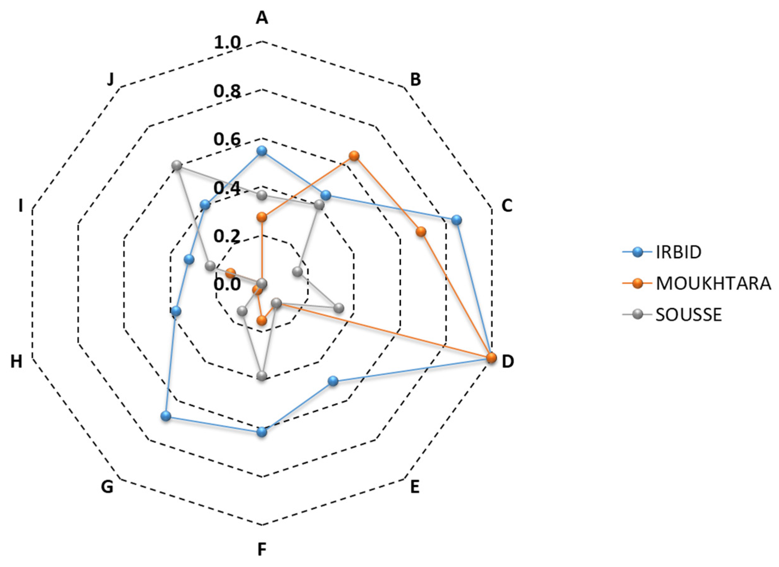
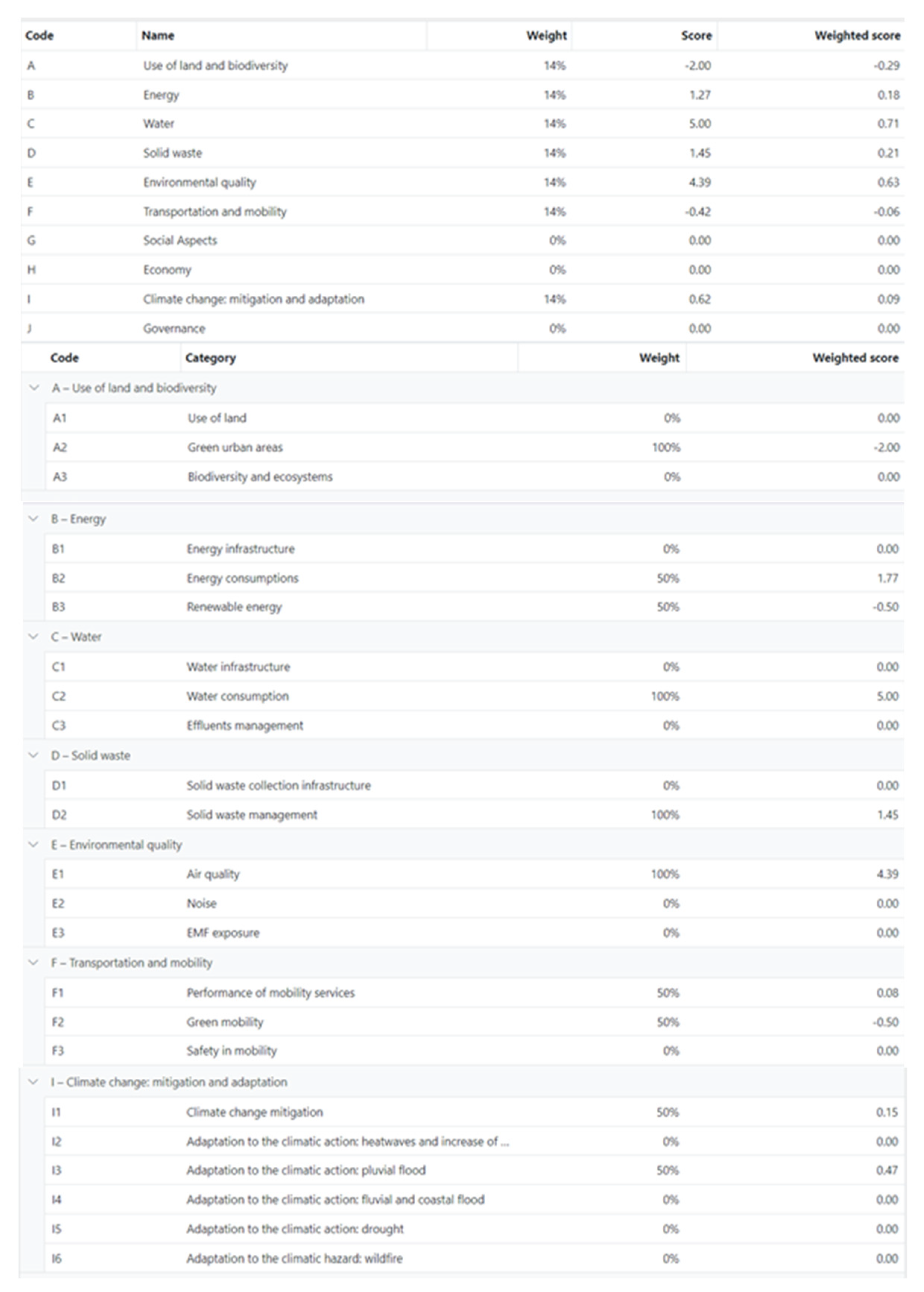
3.3. City Scale

The data collection process at city scale is even more demanding and time-consuming. Once again, GIS can be used to expedite specific data collection in order to quantify relevant indicators like green-covered areas and ground permeability [21].
The city scale includes 39 categories and a total of 99 indicators of which 10 are KPIs that were new additions to the SMC method. The availability of green urban areas (A2.1) is quantified by the total amount of green urban areas in the city’s boundaries divided by the total area of the city (%). Green areas facilitate climate change adaptation and mitigation, improve health and quality of life, and favour biodiversity conservation. A green urban area is defined as urban land covered by vegetation of any kind, for instance natural zones, parks, and public and private gardens, including green roofs. Areas that are without green or natural surface cover are assumed to be sealed (i.e., paved or impervious). Relevant information can be obtained from municipal recreation and parks departments, planning departments, forestry departments and a census. In addition, green areas can be defined from land use and land cover maps, which may further be facilitated by automated processes of GIS resources [21].
The final energy consumption (B2.1) is quantified for the whole city (MWh/inhabitant/yr), including all energy carriers for all sectors (e.g., residential, commercial, industrial, transportation, other). The annual total energy consumption is normalized by dividing by the total population of the city (inhabitants). The share of renewables (%) for final energy (B3.1) is intended to monitor the efforts to maximize the use of renewables. This also reflects the degree to which renewables have substituted fossil and/or nuclear fuels and therefore have contributed to the decarbonisation of the Mediterranean area economy, along with progress towards the 2030 EU target for renewables. The calculations account for all forms of renewables (e.g., solar, wind, geothermal) used for thermal and electrical energy from all sectors (e.g., residential, commercial, industrial, transportation and other).
Water is a valuable natural resource and the total daily water consumption (C2.1) normalized by the total city population (l/day/person) is a direct measure for evaluating water resources in the city and encourage efficient use of water. In some cities of the south Mediterranean basin or some islands, the potable water supply is not constant and households rely on a few hours to tap the available water during the day. Water consumption is much higher in cities of higher income countries. In order to be sustainable, water consumption must be in harmony with the available water resources. This can be encouraged through improvements in water supply and distribution systems, along with changes in water consumption patterns. The scope of the indicator includes the use of potable water for: drinking, sanitation, domestic hot water, washing, gardening, commercial, industrial and agricultural purposes. The relevant data can be obtained from the main water-supply companies. If metered data are not readily available, estimated data can be used, but in all cases the source of the data must be clearly declared.
Solid waste recycling (D2.2) is essential for promoting and developing sustainable waste management. The indicator is expressed as the total amount of solid waste that is recycled divided by the total amount of solid waste produced in the city (%). Municipal solid waste is generated by households, commercial and business establishments, institutions (e.g., schools, hospitals), public spaces (e.g., parks, streets) and construction sites. Generally, it is non-hazardous waste composed of food waste, garden waste, paper and cardboard, wood, textiles, nappies (disposable diapers), rubber and leather, plastics, metal, glass, construction and demolition waste, etc. The priority is to minimize this waste, recycle as much as possible and properly treat the small remaining amounts. The recycled materials refer to the ones that are diverted from the waste stream, recovered and processed into new products following local government permits and regulations. The relevant data can be obtained from the municipal waste collection companies, or estimated in the design phase.
Particulate matter (PM10) concentration (μg/m3) is a commonly used indicator to assess the long-term ambient air quality in the city (E1.2) with respect to the annual average of fine particulate matter (<10 μm). Particulate matter (PM) consists of a complex mixture of solid and liquid particles of organic and inorganic substances suspended in the air, sulfate, nitrates, ammonia, sodium chloride, black carbon, mineral dust and water. PM affects more people than any other pollutant. Coarse particles are greater than 2.5 μm and less than or equal to 10 μm in diameter and are defined as “respirable particulate matter” or PM10. Sources of coarse particles include crushing or grinding operations, and dust from paved or unpaved roads. For measurements, the location of each monitoring station should be carefully selected in order to reflect the local representativeness of the measured values (e.g., airport, city centre, industrial park). Ideally, multiple station locations should be used to determine a spatial average for the city.
The public transport network (F1.1) is quantified by the length of the public transport system per 1000 population (km/1000 inhabitants). The indicator can be used to assess the use of public and municipal transportation, including metro, bus, minibus and tram. The extent of a city’s transportation network can also provide an insight on possible traffic congestion and driving conditions, the transportation system flexibility and the urban form. Cities with larger amounts of public transport might tend to be more geographically compact and supportive of non-motorized modes of transportation. Information on the length of public transport can be gathered from municipal transport offices and local/regional transit authorities or can be calculated from computerized mapping, aerial photography or existing paper maps, all of which should be field-verified. For the calculations, only one-way routes of public transport lines are considered. Transport systems that cover the same route should be counted separately. For example, if a bus and a surface tram cover the same 1 km route, this should count for 2 km.
The bicycle network (F2.4) expressed as the total length of bicycle paths and lanes divided by the city’s total population (m/inhabitant) is an evolving indicator to quantify efforts for promoting cycling as an alternative to vehicle use. The prerequisite is to provide safe and efficient mobility networks. The calculation of bicycle paths can be performed by in situ measurements or by using web map platforms and GIS. The bicycle paths should be physically separated from traffic roads and should not be part of a shared space.
Greenhouse gas emissions (I1.1) quantify the total amount of GHG generated over a calendar year from all sectors, divided by the current city population (tCO2-eq/ inhabitant). The assessment boundary includes the entire city, for energy use and activities from all sectors (e.g., residential, commercial, industrial, transportation, other).
Finally, the percentage of weighted ground permeability (%) expresses the land permeability in order to reduce its impact on the hydrological cycle (I3.1). Permeability of land is the capacity to transmit water to the soil. It is a very important issue connected to the water recharging of aquifers and the reduction in effluents, but also relates to the efforts to possibly reduce the impacts of the heat-island effect and improve outdoor ambient conditions. The calculations of the covered areas by buildings footprints, different hard surface materials, paved roads, sidewalks, green cover and exposed soil can be performed by in situ measurements or by using web map platforms and GIS [21]. The areas covered by the different materials are then multiplied by the reference permeability coefficients (e.g., grass = 1, sand = 0.9, asphalt = 0) to calculate the weighted surface of the city, which is finally divided by the total surface area of the city.

4. Case Studies

The assessment method as well as the tools were validated through a series of pilot applications in public buildings (residences, schools, offices, etc.) and neighbourhoods in three south-east Mediterranean cities. This campaign followed along the footsteps of the previous national case studies for buildings and neighbourhoods performed in south European cities [12].
The pilots were performed in Irbid (Jordan), Moukhtara (Lebanon) and Sousse (Tunisia). As was elaborated in the previous section, the first intent of this effort was to enhance the pool of indicators and the selection of the KPIs during the national co-creation efforts with different stakeholders in the three cities. The contextualization of the national tools was performed by selecting the appropriate number of indicators to reflect their local and national needs, adapting the benchmarks in order to normalize the indicator values and incorporate representative national weights that reflect the local priorities for the different sustainability issues.
The work followed the same protocol in all three pilots, both assessing the existing condition and evaluating different renovation scenarios. The main objective was to verify that the overall method could be successfully implemented in the three countries and that the selected KPIs and indicators can be realistically used in practice. The national case studies provided practical feedback on the availability of the necessary input data for the consistent calculation of the KPIs and the other selected indicators. The selection of the various issues and indicators during the national case studies also revealed some interesting insights on the sustainability priorities given by the participating municipalities. Apparently, the aim of these pilots was to also raise the capacity of the involved municipalities in using the tools through a simulated application and increase their awareness of sustainability issues.
The three pilots revealed some interesting characteristics and other relevant insights reflecting the elaborate work performed during these studies. For example, at neighbourhood scale, the number of indicators selected for the national versions of the method through the participatory approach averaged 47 indicators at neighbourhood scale, ranging from 73 in Irbid (Jordan), to 34 in Moukhtara (Lebanon), and 33 in Sousse (Tunisia), including the 14 KPIs in each case. This is in agreement with the national averages of 39 indicators at neighbourhood scale from previously developed European national versions of the tools [12].
Accordingly, the three nationally contextualized versions of the tools include 25–55% of the total indicators available in the generic framework of the sustainable neighbourhoods tool. The number of indicators per sustainability issue for each one of the national versions is shown in Figure 5. As illustrated, Issue G which refers to social aspects (Table 1) has been allocated the largest number of indicators in the generic framework of the neighbourhood tool. However, the national tool of Moukhtara (Lebanon) has the least active indicators. For Irbid (Jordan), Issue I, which refers to climate change: mitigation and adaptation, has the lowest number of active indicators, while for Sousse (Tunisia) the least number of indicators is included in Issue E on environmental quality. Emphasis is given on solid waste (Issue D) in both Irbid and Moukhtara, while the issue of water appears to have more importance in the case of Sousse.
It is interesting to also note that, beyond the KPIs, only five indicators are common in the three national tools. These include indicators from only three issues: A2.1 (proportion of all vegetated areas within the neighbourhood boundaries in relation to the total area), A2.2 (total area of green in the city divided by the neighbourhood’s total population), B1.1 (percentage of households with authorized access to electricity), B2.10 (total electricity consumption of public street lighting divided by the total distance of streets where street lights are present), and C2.1 (total amount of the area’s water consumption divided by the total area population). Detailed information on the three national case studies is available in [26]. They include a detailed description of the buildings and urban areas considered in the three national studies, their specific characteristics, a sustainability assessment of their existing condition and the results from different renovation scenarios. A detailed comparative assessment of the main characteristics of the contextualized national methods and tools, along with the main results of the three case studies, is summarized in [27].

Hellenic City Pilot

The city-scale tool was also used for a field study in a municipality of the Athens greater metropolitan area. The city has a population of about 40,000 inhabitants, with a very high population density of about 10,500 inhabitants/km2, following intensive residential growth over the last couple of decades. The built environment includes about 14,000 dwellings and about 4000 buildings, of which about one third are not thermally insulated since they were constructed before the first Hellenic thermal insulation regulation.
The final energy consumption is estimated at 10.2 MWh/inhabitant, using fossil fuels for space heating. The use of natural gas was initiated only in 2009 with the first development of a central distribution network and is still expanding through smaller neighbourhoods; thus, the use of heating oil remains the most popular fuel for space heating. The related GHG emissions are estimated at 4.8 tCO2-eq/inhabitant. The share of renewables on the total final thermal energy is estimated at about 15% from the available energy performance certificates that have been issued in the municipality, mainly from the use of solar thermal collectors for domestic hot water. The total water consumption is estimated at 175.6 L/day/inhabitant. The municipality makes a significant effort to maximize solid waste recycling that reaches about 36% of the total amount of solid waste production. The public transport network is not very well developed reaching 2.1 km/1000 inhabitants. However, it is important that the metro and suburban surface rail has two stations in the outskirts of the city, which is very important for daily commutes of the residents to downtown Athens. There is a small bicycle network reaching 0.134 m/inhabitant which needs to be expanded. The land permeability is estimated around 35%. The particulate matter concentration is taken as an average between two monitoring stations in neighbouring municipalities reaching 21.7 μg/m3.
An overview of the various issues, along with the corresponding weights and scores, is summarized in Figure 6. The results are presented in relation to the KPIs alone. Accordingly, all other categories are identified with zero weights. For the remaining ones, the default is to equally distribute and allocate the weights. However, as was previously elaborated, these weights may be adjusted and tailored to match the priorities of a local authority or that of a specific project, if necessary.
The final results and sustainability score are presented in Figure 4. The assessment of the existing condition resulted in a sustainability score of 1.4, which may be considered good. For existing urban projects, a realistic sustainability target to aim at is usually around 2.0 to 2.5.

5. Conclusions

This paper reviewed the progress made with the evolution of an open common transnational assessment system for measuring the level of sustainability at the different spatial scales, from buildings to cities, implementing the “think globally, act locally” concept. The method and supporting tools have been enhanced and successfully tested at three pilots in south-east Mediterranean municipalities. The method and the assessment system are addressed to local authorities and municipalities for supporting them in the overall decision-making process towards sustainability. They can be utilized to strengthen the capacity of stakeholders to provide services for assessing, planning and monitoring sustainability projects.
The overall approach facilitates the process of handling the complexities of addressing the multifaceted sustainability issues. It also provides sufficient flexibility to adapt the generic method to match specific national and local priorities and characteristics. In addition, users can evaluate, compare and aggregate the results of sustainability measures in different buildings and cities (act locally) and, at the same time, they can evaluate the progress towards global sustainability targets (think globally).
The use of common indicators can be used to fix measurable targets in effective policies and action plans in relation to the Mediterranean strategy for sustainable development and facilitate the exchange of best practices through the use of key performance indicators. The overall method and tools are also supported by educational and training material that is specifically developed and targeted for professionals, technical personnel and decision makers of the municipalities. This way it is possible to initiate and sustain local efforts towards sustainability, overcome challenges and achieve progress that benefits citizens and local communities.
At this stage, the method does not include specific cost-related information for assessing different design options or renovation scenarios. This is an important element in the decision-making process in order to facilitate the cost-benefit analysis and facilitate the complete appraisal of different projects or specific actions. The tools will also need to be adapted and contextualized in areas outside the participating countries. However, on a positive note, there are already several national versions available in southern Europe and south-east Mediterranean countries.
Future work will continue the efforts on contextualizing the method to other regions and possibly countries. The ambition is to also facilitate and support national standardization efforts for sustainability assessment of buildings, cities and regions. Relevant activities may also be inspired from the overall concept in order to develop similar methods and tools for measuring and assessing resilience and the impacts of climate crisis or other natural events and disasters on urban environments. In this regard, there will also be a need to give special attention to the structural assessment of buildings and other infrastructures, since their failure is critical for sustainable communities [28]. For example, we may need to first assess the ability to maintain a certain level of functionality following different natural or other events, and to also consider the necessary time and the need of resources that will be required to repair or restore minimum functionalities. These issues may be of particular importance when dealing with the sustainability of multifunctional structures like tall buildings [29] and other infrastructures like bridges [28].

Author Contributions

Conceptualization, A.M.; methodology, A.M.; software, A.M. and S.K.; formal analysis, C.A.B., K.G.D., E.B., E.G.D., S.K., P.B. and A.M.; investigation K.G.D.; data curation, C.A.B., E.B., K.G.D., E.G.D., S.K., P.B. and A.M.; writing—original draft, C.A.B.; writing—review and editing, K.G.D., E.G.D., S.K., A.M., P.B. and E.B.; visualization, C.A.B.; project technical coordinator, A.M.; funding acquisition, A.M. All authors have read and agreed to the published version of the manuscript.

Funding

This research was co-funded during the European project Sustainable MED Cities (10/2021–12/2023) that was part of the ENI CBC Med a Cross-Border Cooperation (CBC) initiative implemented by the EU under the European Neighbourhood Instrument (ENI), under Grant Contract C_B.4.3_0063. The APC was also funded by the same source.

Data Availability Statement

All relevant data is contained within the article.

Acknowledgments

This work was performed in the frame of the European project Sustainable MED Cities—Integrated tools and methodologies for sustainable Mediterranean cities (https://www.enicbcmed.eu/projects/sustainable-med-cities accessed on 20 December 2023) as a collaborative effort of six partners from six countries, including the Government of Catalonia (Spain) as Lead Partner, iiSBE ITALIA R&D (Italy), the Municipality of Sousse (Tunisia), Moukhtara Municipality (Lebanon), Greater Irbid Municipality (Jordan) and the National Observatory of Athens (Greece), and two associate organizations including the United Nations Environment Programme—Mediterranean Action Plan Coordinating Unit–Barcelona Convention Secretariat, and Asociación MedCities. The Sustainable MED Cities project capitalized on the Interreg MED project “CESBA MED: Sustainable Cities” with the ENI CBC MED project “GreenBuilding”. This paper reflects the views only of the authors who have made every effort to prepare this material for the benefit of the public in light of current and available information. It does not represent the opinion of the European Union. Neither the European Union institutions and bodies nor the authors may be held responsible for the use which may be made of the information contained therein.

Conflicts of Interest

The authors declare no conflict of interest.

References

  1. Energy Statistical Pocketbook and Country Datasheets. 18 August 2023. Available online: https://energy.ec.europa.eu/data-and-analysis/eu-energy-statistical-pocketbook-and-country-datasheets_en (accessed on 9 September 2023).
  2. COM(2021) 550 Final Fit for 55: Delivering the EU’s 2030 Climate Target on the Way to Climate Neutrality; European Commission: Brussels, Belgium, 2021. Available online: https://eur-lex.europa.eu/legal-content/EN/TXT/?uri=CELEX%3A52021DC0550 (accessed on 20 September 2023).
  3. UN Climate Action. Generating Power—Cities and Pollution. United Nations: New York, NY, USA. Available online: https://www.un.org/en/climatechange/climate-solutions/cities-pollution (accessed on 9 September 2023).
  4. Ulpiani, G.; Vetters, N.; Shtjefni, D.; Kakoulaki, G.; Taylor, N. Let’s hear it from the cities: On the role of renewable energy in reaching climate neutrality in urban Europe. Renew. Sustain. Energy Rev. 2023, 183, 113444. [Google Scholar] [CrossRef]
  5. Urban Environment. European Commission: Brussels, Belgium. Available online: https://environment.ec.europa.eu/topics/urban-environment_en (accessed on 20 September 2023).
  6. Hunter, G.W.; Vettorato, D.; Sagoe, G. Creating Smart Energy Cities for Sustainability through Project Implementation: A Case Study of Bolzano, Italy. Sustainability 2018, 10, 2167. [Google Scholar] [CrossRef]
  7. EU Mission: Climate-Neutral and Smart Cities. European Commission: Brussels, Belgium. Available online: https://research-and-innovation.ec.europa.eu/funding/funding-opportunities/funding-programmes-and-open-calls/horizon-europe/eu-missions-horizon-europe/climate-neutral-and-smart-cities_en (accessed on 9 September 2023).
  8. Green City Accord—A European Commission Initiative to Make Cities Greener, Cleaner and Healthier. Available online: https://environment.ec.europa.eu/topics/urban-environment/green-city-accord_en (accessed on 20 September 2023).
  9. EU Green Capital & EU Green Leaf Awards. Available online: https://environment.ec.europa.eu/topics/urban-environment/european-green-capital-award_en (accessed on 20 September 2023).
  10. EU Sustainability, Buildings and Construction. European Commission: Brussels, Belgium. Available online: https://single-market-economy.ec.europa.eu/industry/sustainability/buildings-and-construction_en (accessed on 20 September 2023).
  11. Gavalda, O.; Gibbs, C.; Eicker, U. A Review of Current Evaluation Urban Sustainability Indicator Frameworks and a Proposal for Improvement. Sustainability 2023, 15, 15425. [Google Scholar] [CrossRef]
  12. Balaras, C.A.; Droutsa, K.G.; Dascalaki, E.G.; Kontoyiannidis, S.; Moro, A.; Bazzan, E. Urban Sustainability Audits and Ratings of the Built Environment. Energies 2019, 12, 4243. [Google Scholar] [CrossRef]
  13. CESBA MED for Sustainable MED Cities. Interreg Mediterranean, European Regional Development Fund: Marseille, France. Available online: https://cesba-med.interreg-med.eu/ (accessed on 20 September 2023).
  14. MSSD Mediterranean Strategy for Sustainable Development. United Nations Environment Programme, Mediterranean Action Plan Barcelona Convention: Athens, Greece. Available online: https://www.unep.org/unepmap/what-we-do/mediterranean-strategy-sustainable-development-mssd/ (accessed on 20 September 2023).
  15. Level(s) European Framework for Sustainable Buildings. European Commission: Environment. Available online: https://environment.ec.europa.eu/topics/circular-economy/levels_en (accessed on 20 September 2023).
  16. ISO 37120:2018; Sustainable Cities and Communities—Indicators for City Services and Quality of Life. International Organization for Standardization: Geneva, Switzerland, 2018. Available online: https://www.iso.org/standard/68498.html (accessed on 20 September 2023).
  17. UN Sustainable Development Goals; United Nations: New York, NY, USA, 2019; Available online: https://www.un.org/sustainabledevelopment/sustainable-development-goals/ (accessed on 20 September 2023).
  18. Droutsa, K.G.; Balaras, C.A.; Dascalaki, E.G.; Kontoyiannidis, S. D3.1.4. MED Passport and KPIs; SMC Consortium: Barcelona, Spain, 2022; 139p. [Google Scholar]
  19. SMC e-Learning Platform. Available online: https://www.smc-elearning.eu (accessed on 20 September 2023).
  20. Balaras, C.A.; Dascalaki, E.G. Chapter 9.1—Energy Audits of Existing Buildings, pp. 677–713 in Chapter 9—Energy Efficiency in Building Renovation. In Handbook of Energy Efficiency in Building, 1st ed.; Asdrubali, F., Desideri, U., Eds.; Butterworth-Heinemann Elsevier Ltd.: Oxford, UK, 2018; 836p. [Google Scholar] [CrossRef]
  21. Balaras, C.A.; Theodoropoulos, A.I.; Dascalaki, E.G. Geographic Information Systems for Facilitating Audits of the Urban Built Environment. Energies 2023, 16, 4309. [Google Scholar] [CrossRef]
  22. Dascalaki, E.G.; Argiropoulou, P.A.; Balaras, C.A.; Droutsa, K.G.; Kontoyiannidis, S. Benchmarks for Embodied and Operational Energy Assessment of Hellenic Single-Family Houses. Energies 2020, 13, 4384. [Google Scholar] [CrossRef]
  23. ICE Database, Inventory of Carbon and Energy, Circular Ecology. Available online: https://circularecology.com/embodied-carbon-footprint-database.html (accessed on 20 September 2023).
  24. European Commission. Energy. Smart Readiness Indicator. Available online: https://energy.ec.europa.eu/topics/energy-efficiency/energy-efficient-buildings/smart-readiness-indicator_en (accessed on 20 September 2023).
  25. Balaras, C.A.; Dascalaki, E.G.; Psarra, I.; Cholewa, T. Primary Energy Factors for Electricity Production in Europe. Energies 2023, 16, 93. [Google Scholar] [CrossRef]
  26. D5.2.2 Test of WP3 and WP4 Outcomes. Final Report—Sustainable MED Cities. December 2023. Available online: https://www.enicbcmed.eu/projects/sustainable-med-cities (accessed on 20 September 2023).
  27. Droutsa, K.G.; Balaras, C.A.; Dascalaki, E.G.; Kontoyiannidis, S. D5.2.3. Evaluation of Results. Final Report—Sustainable MED Cities. Institute for Environmental Research & Sustainable Development (IERSD), National Observatory of Athens (NOA). December 2023. Available online: https://www.enicbcmed.eu/projects/sustainable-med-cities (accessed on 20 September 2023).
  28. Forcellini, D. The Role of Redundancy of Infrastructures on the Seismic Resilience (SR) of Sustainable Communities. Sustainability 2023, 15, 11849. [Google Scholar] [CrossRef]
  29. Forcellini, D.; Kalfas, K.N. Inter-story seismic isolation for high-rise buildings. Eng. Struct. 2023, 275, 115175. [Google Scholar] [CrossRef]
Figure 1. Breakdown of final energy use in EU-27 Member States since 1990. The symbols identify the 2020 and 2030 targets, along with their corresponding linear trajectory. Data source: [1].
Energies 17 00082 g001
Figure 2. Greenhouse gas emissions in EU-27 Member States since 1990. The symbols identify the 2020 and 2030 targets, along with their corresponding linear trajectory. Data source: [1].
Energies 17 00082 g002
Figure 3. Representative captions from the assessment tool for the description of two indicators: (a) B.1.1 Primary energy demand; (b) C1.1 Embodied carbon.
Energies 17 00082 g003
Figure 4. Representative results on the tool interface from a pilot study. The results are summarized on a spider chart that illustrates the target scores for each sustainability issue (black symbols and outline). The scores for the existing condition are illustrated with the cyan symbols and outline. The doughnut chart summarizes the weights of the different issues. The total sustainability score for the project is identified at the top.
Energies 17 00082 g004
Figure 5. Ratio of active indicators per issue in the three national neighbourhood tools with regard to the generic framework. The letters correspond to the sustainability issues that are defined in Table 1.
Energies 17 00082 g005
Figure 6. Representative results from a pilot study in Greece. The summary of the scores for the 10 issues at city scale appears at the top, followed by the corresponding active categories associated with the KPIs.
Energies 17 00082 g006
Table 1. Sustainability issues for the building and neighbourhood–city scales.
Building ScaleNeighbourhood–City Scales
A—Site Regeneration and Development, Urban Design and InfrastructureA—Use of land and biodiversity
B—Energy and Resources ConsumptionB—Energy
C—Environmental LoadingsC—Water
D—Indoor Environmental QualityD—Solid Waste
E—Service QualityE—Environmental Quality
F—Social, Cultural and Perceptual Aspects F—Transportation and Mobility
G—Costs and Economic Aspects G—Social Aspects
H—Adaptation to Climate ChangeH—Economy
I—Climate Change: Mitigation and Adaptation
L—Governance
Disclaimer/Publisher’s Note: The statements, opinions and data contained in all publications are solely those of the individual author(s) and contributor(s) and not of MDPI and/or the editor(s). MDPI and/or the editor(s) disclaim responsibility for any injury to people or property resulting from any ideas, methods, instructions or products referred to in the content.

