Abstract
The growing awareness of environmental issues, climate policies, and rapidly developing technologies is contributing to the increasing number of battery electric vehicles (BEVs) around the world. A key requirement for their widespread implementation is providing a charging infrastructure that allows users to operate these vehicles comfortably. Lack of access to charging stations can be a major barrier to the development of electromobility in a given area. Therefore, each additional charging infrastructure can support a change in the structure of the vehicle fleet. One of the key challenges facing this transformation is the selection of suitable locations for charging stations. It is necessary to ensure that they are uniformly distributed so that range anxiety for EV users is reduced and equal access to charging infrastructure is provided to all residents. One of the most important stakeholders in this market is local authorities. Therefore, the objective of this research was to develop a method of determining optimal locations for electric vehicle charging stations (EVCSs) from the perspective of local authorities that also takes into account equal access to the charging infrastructure for all residents, which seems to be a unique approach to this problem. We used commonly available spatial data as input to enable the method to be applied on a larger scale and over an urban area. We carried out our research using a case study: the city of Gliwice in Poland. The city area was divided into hexagonal basic fields, for which potentials for locations of new charging stations were calculated. The analysis was carried out using the geographic information system (GIS) QGIS (ver. 3.34).
1. Introduction
With the rapid development of automotive technology and growing interest in ecofriendly transportation solutions, electric vehicles (EVs) are becoming increasingly popular worldwide []. Reducing greenhouse gas emissions and air pollution, and gradually becoming independent of fossil fuels, are key benefits associated with their deployment []. However, one of the main challenges associated with the widespread adoption of electric vehicles is the availability of electric vehicle charging stations (EVCSs) [,,]. In particular, the proper location of the EV charging infrastructure in urban areas is crucial in ensuring convenience for EV users; therefore, it is crucial in encouraging residents to own such vehicles [].
Studies in Germany, Brazil, and the United States [,,,] have shown that the problem of unequal access to EVCSs in urban areas is widespread. A correlation has been indicated between some characteristics describing the socioeconomic situation and the availability of EVCSs. For example, the number of existing stations depends on the type of area (urban/rural) [], the material status and age of inhabitants, and the ownership of dwellings [,]. The authors also point out large regional differences, which are often connected to the historical circumstances and developmental lags of the areas concerned. Therefore, locations for EVCSs may not match the demand [].
The most appropriate actors to address this problem and equalize the availability of EVCSs for all residents are local authorities. Their role may be to fill the gap, indicate the places where public EVCSs should be located, and decide where commercial EVCSs should not be built, for different reasons.
Our review of the literature showed that different criteria and various methods have already been developed to address the problem of the location of EVCSs. However, there is still a research gap in analyzing the problem of determining the locations for EVCSs both from the point of view of local authorities and equal access to charging infrastructure for area residents. Our research is an attempt to solve this problem. The method we propose takes into account the perspective of local authorities and the determinants related to sustainable development that are important to them. Therefore, this is a new approach to determining optimal locations for EVCSs.
The requirement we set for the data needed in our method was that they should be accessible via public and open-access databases. We wanted to use only data that are publicly available so as to not incur any additional costs for local authorities when using our method. Therefore, the tools we use in our approach are based on geographic information system (GIS) and the use of a database that is publicly available in Poland, the Polish National Databases of Spatial Data (the BDOT10k database).
The main aim of this article was to present a GIS-based method that can be a useful tool for local authorities in supporting decisions regarding the locations of EVCSs in urban areas. This article also presents a broad analysis of key factors that have been considered in previously used approaches, which allowed us to highlight the research gap and select factors that are important in supporting different decision-making processes.
The method proposed in the present article places particular emphasis on providing residents with equal access to the EV charging infrastructure. Therefore, it can respond to the challenges of contemporary transport and act as a valuable tool for local authorities in their efforts to increase access to EVCSs. Consequently, it can support the electrification of individual road transport vehicles and the achievement of environmentally friendly policy objectives.
The main hypothesis in this paper is that the potential of a given location for a new and publicly accessible EVCS can be evaluated based on the features of the built environment. We also raised the following research questions:
- Which factors associated with the features of the built environment will effectively represent the actual potential?
- How should the stations be spatially distributed to ensure equitable access to them?
This article also presents a case study conducted for the city of Gliwice in Poland. According to 2023 data, there are about 20 EVCSs in the city. As a result of using the proposed method, five additional places were recommended for further EVCSs.
The present article is divided into five parts. The purpose of the developed method and the structure of this article are presented in the Introduction (Section 1) against the general background of the issues analyzed. Section 2 presents a review of the literature on selected areas related to locations for EVCSs, including social, spatial, economic, legal, technical, and environmental aspects. Section 3 presents the general assumptions and a description of the method for determining the locations for EVCSs in urban areas. Section 4 contains the results of the research carried out using the proposed method for the medium-sized city of Gliwice in Poland. The final sections (Section 5 and Section 6) include a discussion of the results, directions for further research, and conclusions. Appendix A contains the notation, a formal description of the method, and its algorithm.
2. Literature Review
One of the main challenges of electromobility development in urban areas is the identification of criteria that are required to assess the potential of a given location for an EVCS and to select the best places for building EV charging infrastructure. Figure 1 presents a set of criteria related to the issue of determining the locations of EVCSs, which is the basis of the literature review.
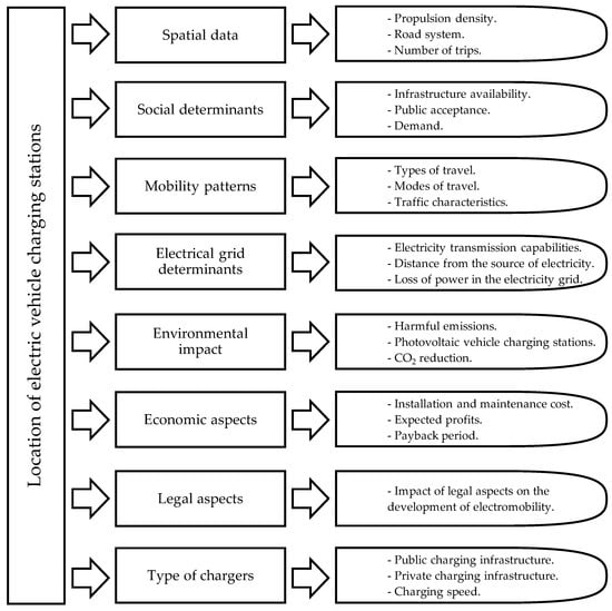
Figure 1.
Structure of the literature review in this article (source: own elaboration).
During the literature review, considerable complexity in the issue and a variety of approaches to the problem of determining the locations for EVCSs were observed. The individual aspects presented in Figure 1 are discussed in detail in the following subsections.
2.1. Spatial Data
One of the most commonly used data sources in determining the optimal locations for EVCSs is spatial data. The main advantages of this type of data are their wide availability, reliability, diversity, and ease of use. In the case of the data used in the analysis [] developed for the example of the city of Łódź, the optimization criteria were as follows:
- Distance from petrol stations;
- Distance from shopping centers and supermarkets;
- Population density;
- Distance from parking lots;
- Location in relation to parks;
- Location in relation to existing EVCSs;
- Distance from the main roads that traverse the city (at least the regional roads).
Point of Interest (POI) data are very often used to assess locations for EVCSs. They are often classified into specific categories, as in article [], where nine groups are listed based on business categories according to NAICS (North American Industry Classification System). On the other hand, in article [], a geographic information system (GIS) was used to obtain information on population, jobs, number of cars in high-income areas, and households without cars, as well as the number of students, walking trips, and the total number of trips. The authors of the publication used aggregated data to solve the Set Covering Location Problem (SCLP) and Maximum Location Problem (MCLP). The former is a classic optimization problem consisting of selecting the location for a specified number of charging facilities in such a way as to minimize investment costs and maximize the efficiency of covering a given area. The MCLP problem, in turn, concerns the maximization of benefits from resources that are limited. On the contrary, a case study of Dublin used multi-criteria analysis with GIS [] and data including population density, the layout of major roads, the number of trips to places of work and study, and the location of parking lots, lamps, housing, and public facilities. The data used came from the National Statistics Office and OSM.
GIS tools were also used to optimize the locations for photovoltaic EVCSs in a study developed for the city of Qingdao in China [] and in analyses conducted in Salt Lake City []. The authors of the publication [] analyzed the current network of EVCSs in the area of Hahhot, China, based on spatial data on urban land use, charging practices, and travel patterns of electric vehicle users. The second part of their study included a plan for the future development of the vehicle charging system in the area. According to the authors, the most important variables for planning the deployment of EVCSs are the level of charging demand, the coverage of each point in terms of the territory served, and the construction cost [].
2.2. Social Determinants
Demographic and social factors largely determine the optimal locations for EVCSs. This is evidenced by a study conducted in Hong Kong [] that assessed the demand for vehicle charging based on surveys, taking the propensity to purchase an electric vehicle as a reference point. The influence of socio-demographic factors such as age, gender, education level, marital status, employment status, household size, income, and place of residence was examined. The results showed that groups of older respondents (≥45 years) were less likely to purchase an electric vehicle compared with the younger age group (18–34 years). Respondents who were self-employed, married, and living in owner-occupied houses and apartments were also more likely to purchase an electric vehicle. Consequently, the owners of electric cars will also become a group of EVCS users. This is also reflected in a study from South Korea [], which analyzed the factors within a radius of about 914 m from existing stations, including the number of registered EVs and the value of the land, which can approximate the income level.
In turn, the authors of [] proposed selecting locations for EVCSs based on the application of the graph convolutional network (GCN) method, which is the basis of deep learning technology. This technology was used to analyze the distribution of EVCSs based on the distribution of social classes in China. The study showed that the business area should have the infrastructure with the fastest charging capability to meet the requirements of the most demanding customers. The combination of fast and slow chargers is beneficial in residential areas.
2.3. Mobility Patterns
The analysis of traffic patterns and driver behavior is another important aspect. Models that take these factors into account often use data collected from GPS systems, traffic surveys, and big data analysis to identify the locations with the greatest potential. A study conducted in Canada [] using data from the operation of over 7000 EVCSs also showed that user behavior patterns were very important factors influencing EVCS usage, including usage at particular times of the day. This also affects the operation and stability of the electric power system. The research confirmed that charging patterns and times reinforce the “duck curve” problem of energy production, which presents a growing challenge to ensure the stability of the network.
Logistic patterns were also analyzed in a simulation model developed for Gothenburg []. The study presented a methodology for the deployment of fast EVCSs for the city’s logistics operators. The main objective of the study was to minimize total costs by optimizing the locations and number of chargers at each station. The authors showed that the most beneficial locations for the deployment of EVCSs were private EVCSs in vehicle parking areas (because of long overnight stops) and shared or public EVCSs in important and frequently visited locations along delivery routes.
The study [] focused on optimizing the locations for EVCSs to facilitate long-distance travel and meet urban demands. Based on the research, traffic volume, distance from the nearest EVCS, and the range of services available on the market were indicated as the main variables influencing the use of EVCSs on expressways in Budapest. Furthermore, studies in Austria [] found that 88% of vehicle charging took place when the user was at home. Almost ten times less charging took place in workplaces, and only 1.7% used public EV charging stations.
2.4. Electrical Grid Determinants
Another important factor considered in decision-making models is the location of an EVCS in the electricity network. Since the charging infrastructure has to ensure that the parameters of the distribution network are adequate, cooperation and coordination with power suppliers are essential. For this reason, many studies also present an optimization approach in terms of local energy supply capacity or the costs associated with providing such capacity. For example, the paper [] proposed the optimal placement of fast chargers at different locations in the electricity distribution system using Multiple Objective Particle Swarm Optimization (MOPSO), so that power losses and voltage deviations are kept to a minimum. Attempts were also made to combine transportation and network-related criteria in optimization models. A large-scale study on the example of Thailand [] also considered energy efficiency, measured by network power loss. A broad review of approaches to optimizing the locations for EVCSs is presented in the article []. The authors paid particular attention to the need for a comprehensive approach to this problem and proposed an authoritative, multi-stage model for optimizing the locations and sizes of EVCSs.
The optimal deployment of EVCSs requires an analysis of potential charging demand and vehicle traffic patterns to estimate energy consumption. In addition, the projection and implementation of the planned locations for EVCSs must be based on an analysis of the local electricity distribution network to ensure the optimal efficiency of the designed solution and an acceptable level of power. The article [] provided an extensive review of the CSLP (Charging Station Location Problem), focusing on modeling and solving problems from different perspectives. According to the authors, the following aspects are important when designing a network of EVCSs:
- Estimation of the charging demand;
- Range of the electric vehicle;
- Efficiency of the currently used vehicle charging system;
- Distance of the designed charging point from the power source;
- Strategic decisions and their impacts on the development of the charging network.
2.5. Environmental Impact
The need to minimize environmental impact is also reflected in the current research. Considerations include the use of renewable energy sources to power EVCSs, as well as reducing air and noise pollution []. For example, in the model [] developed for the city of Tunis, the main criteria considered were maximizing the use of energy from photovoltaic panels and minimizing the use of the power network. Another example can be found in the article [], which included a study on the implementation of batteries in electric buses used for public transport. The researcher developed a model to optimize the cost of implementing the above solution and its impact on greenhouse gas emissions in the city of Guelph in southern Canada.
The authors of the publication [] addressed the integration of EVCSs with randomly distributed rooftop photovoltaic systems. The aim was to optimize the placement of EVCSs in a way that consumed the excess energy transferred to the network by local photovoltaic systems.
2.6. Economic Aspects
Economic factors such as the cost of installing and maintaining a station, as well as the expected profits, are integral parts of the decision-making process. Cost–benefit analyses often also consider the time costs of station users, such as the need to travel to an EVCS. The Multi-Objective Simulated Annealing Particle Swarm Optimization (MOSAPSO) algorithm [] was used to solve the problem with a multi-criteria function consisting of criteria that described the investment cost, the operation and maintenance cost, the payback period, and the time cost of the user of a fast EVCS. The analysis also considered the difficulty (time) of reaching the EVCS and the classification of the development function based on the location of POIs. The extensive multi-criteria analysis proposed in the article [] on the example of the city of Zagazig in Egypt accounted for 19 decision criteria, including the number of utilities, operation and maintenance costs, consumption level, construction costs, and land and equipment costs. However, in the article [], which considered the multi-criteria Analytic Hierarchy Process (AHP) method in combination with the objective programming method, the conversion goal programming model (CAGM) was used to allocate EVs to the most appropriate EVCSs, minimize the level of energy consumption, minimize operation time, and minimize charging costs and battery degradation. Researchers in Germany [], using a simulation model, investigated the deployment of an EVCS under the assumption that 100% of the vehicles used in the Berlin area would be electric. The main criteria were capital costs and average overage of users.
2.7. Legal Aspects
The authors of an article that proposed the deployment of EVCS along the TEN-T road network in Poland [] also paid attention to the need to account for legal aspects when choosing locations for EVCSs. The first aspect is the regulation on alternative fuel infrastructure—AFIR []—which assumes, among others, the construction of fast electric vehicle compartments (EVCSs) for passenger cars and trucks, as well as hydrogen refueling stations on the entire TEN-T network. The method adopted by the authors consisted of several steps. The first was the potential existing sites along the road network where EVCSs could be built. Then, the operators of Rest and Service Areas (RSAs) were asked to indicate the locations they assessed as the most needed. In the next step, data collected in a study commissioned by the European Automobile Manufacturers Association (ACEA) and conducted by Fraunhofer ISI [] were used. Data on the GPS coordinates of around 400,000 trucks in Europe allowed the identification of regular truck stops as optimal locations for EVCSs. In addition, traffic volumes on routes within the TEN-T network in Poland were taken into account. Through consultations with electricity network operators, the necessary investment costs in the distribution networks were estimated to be able to connect the required connection capacity. The time required to realize the above infrastructure investments was also assessed for individual locations.
2.8. Type of Chargers
A study conducted in Switzerland [] also indicated the significant role of public policies in shaping and developing electromobility. The authors divided chargers into the following types: private (home), public in residential areas, public slow, and public fast. They analyzed the development of the car fleet structure until 2050 depending on the development and changes in the availability of the different types of EVCSs. The authors indicated the important role of private and public chargers in residential areas in changing the structure of the car fleet to one that is less carbon-intensive. The authors of the model developed for Brussels [] emphasized a similar problem. In the first step, they estimated the demand for charging electric vehicles based on aggregated mobile data. Then, they analyzed what the segmentation of demand for charging EVs for different charging technologies should look like. Based on OSM data, the classification of urban development types, and POIs, they presented a model for optimizing the occupancy rate of stations according to the type of charger, i.e., normal, semi-fast, or fast-charging, thus maximizing their economic efficiencies.
2.9. Summary of the Literature Review
The choice of optimal locations for EVCSs is a key issue in the development of EV infrastructure. Deployment decisions affect the efficiency of the charging system and power network, the convenience for users, the general acceptance of electric vehicles, and, in the future, the stability of the energy system. There are several factors considered when selecting the locations for EVCSs, which are discussed in more detail below. A summary of the decision criteria found in the literature review is shown in Table 1.

Table 1.
Decision criteria used in selected models.
Taking into account the above literature review, a great variety of approaches can be observed, indicating the considerable complexity of the problem of locating charging stations for electric vehicles in urban areas. However, among the analyzed publications, we did not find methods that approach the problem from the perspective of local authorities or consider the uniform distribution of charging stations, concerning the criteria related to the locations of residential buildings, access to public transport, and public facilities. Therefore, the contribution of our research is as follows:
- Our method takes into account the perspective of local authorities, striving to ensure the availability of electric vehicle charging infrastructure for residents and guests using public facilities;
- Our method considers the locations of public transport infrastructure, which may encourage owners of electric vehicles to use the services of this system in their urban travel, thus contributing to the sustainable development of transport in cities;
- Our method is based on GIS tools and a publicly available spatial database, which significantly reduces the costs of its use;
- Our method can be used by local authorities as a decision support tool in selecting the best locations for electric vehicle charging stations, taking into account existing facilities of this type.
3. Materials and Methods
3.1. General Method Assumptions
The study area was divided into identical basic fields. There are many ways to divide an area into regular basic fields []. In this approach, the hexagon shape was chosen. For each hexagon, the neighborhoods of the 1st and 2nd levels were determined according to the principle presented in Figure 2. This shape of the basic fields was selected because of the several positive features of hexagons. Hexagonal fields are more similar to circles than square and triangular fields. Therefore, each point inside a hexagon is located closer to the center than in the case of the basic field of another shape. Moreover, the use of a hexagonal grid allows for determining a set of neighborhood fields in a quite precise way, and the center of each neighboring hexagon is within the same distance.

Figure 2.
The hexagon under study and hexagons of its 1st and 2nd neighborhood levels.
The purpose of the method is to support decisions on the selection of new locations for EVCSs, taking into account the characteristics of the spatial development of the area under study. Publicly available data collected from the BDOT10k database were used. This object-oriented database contains the spatial location of topographic objects along with their characteristics. The content and details of the BDOT10k database correspond to a topographic map at a scale of 1:10,000. The method used GIS tools, which are increasingly used in transport decision-making problems, for example, for forecasting transport demand [], assessing the accessibility of public transport [,,], assessing the spatial integration of bike-sharing stations [], and even for conducting analyses of innovative solutions introduced in the future [] and risk analyses [].
Table 2 provides information on the layers used for the analysis.
Table 2.
Information on the layers used for the analysis.
The assumptions adopted in the proposed approach are presented in three main groups as follows:
- Assumptions regarding the division of space, including the following:
- −
- The area is divided into basic hexagonal fields;
- −
- Only the basic fields that are entirely within the administrative boundaries of the area under study are considered in the analysis;
- −
- The first level of the neighborhood is considered when determining the potential of the hexagon for new locations for EVCSs.
- Assumptions regarding available data, including the following:
- −
- The potential of each hexagon for the new location for EVCS is determined based on selected data available in the BDOT10k database;
- −
- When determining new locations for charging stations, the locations of existing stations are taken into account, which requires information on these locations;
- −
- The number of new locations for EVCSs is known, and it is one type of input data;
- −
- The method does not take into account the number of charging sites in individual locations.
- Assumptions regarding the criteria for selecting recommended locations for EVCSs, including the following:
- −
- The locations for EVCSs should be evenly distributed across the studied area;
- −
- The potential of a single hexagon for location for EVCS includes three types of development as follows: residential area (taking into account the number of floors), connection to public transport (e.g., transfer centers, bus stations, bus stops, and railway stations), and public facilities (e.g., hospitals, sports facilities, museums, cinemas, offices, post offices, schools, etc.).
The recommended locations for EVCSs are determined based on the potentials of the basic fields for new locations for EVCSs. As a consequence of the assumptions adopted, the locations for EVCSs are determined with hexagonal accuracy, which means that the method indicates a set of hexagons in which new locations for EVCSs are recommended. In our method, we assume that ensuring equal access to the electric vehicle charging infrastructure will contribute to the greatest possible coverage of this area, with EVCSs and increase the accessibility of such facilities, which may have a positive impact on the decision-making process regarding the ownership of EVs by residents of a given area and people using its facilities [].
The method is intended to act as a tool that supports local authorities in making decisions on the locations for EVCSs. Therefore, special emphasis is placed on ensuring the accessibility of this type of infrastructure for residents while maintaining the principles of sustainable development, including promoting the use of public transport services when traveling.
3.2. Description of the Method
The general scheme of the method is shown in Figure 3. The method consists of five stages. The final stage is iterative.
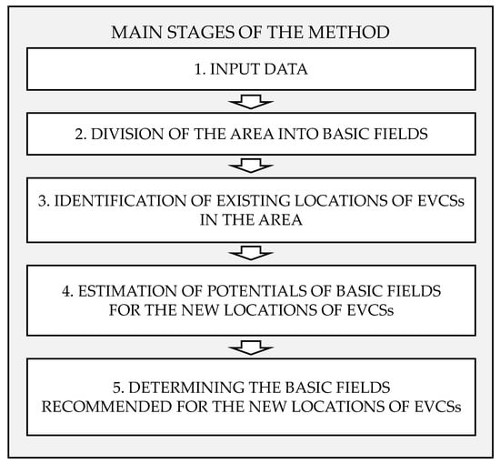
Figure 3.
The main stages of the method.
This section only discusses the general operation principle of the method. Appendix A contains the notation and a detailed flowchart of the algorithm as well as a description of the procedures considered in the proposed method in each of the stages.
In the stage when input data are entered (stage 1), it is required to determine the spatial boundaries of the area, select the method of dividing the space (i.e., the shape and size of the basic fields), and specify the number of new locations for EVCSs. The size of the basic field depends primarily on the availability of spatial data that enable the identification of development facilities in a single field and acceptable access (mainly walking time) to an EVCS by potential users of these facilities. Hexagonal shapes of the basic fields were adopted for the analysis.
In the second stage, the space of the analyzed area is divided into basic fields based on the assumptions adopted. As a result of this process, a set of basic hexagonal fields is created along with sets of hexagons on the first and second levels of the neighborhood according to the principle presented in Figure 2.
Stage 3 of the method consists of identifying the locations of existing EVCSs and assigning them appropriate hexagons based on the previously performed space division.
When determining the potential of a single hexagon for the new location for an EVCS (stage 4), the characteristics of various types of objects are considered. They are classified into three main groups as follows:
- Group 1—objects related to residential buildings;
- Group 2—objects related to public transport;
- Group 3—objects related to public utility facilities.
Then, the range of variability in each parameter is divided into classes, which allows for assigning each hexagon to the appropriate class. Each hexagon under study is rated according to the Formulas (A21)–(A23) (see details in Appendix A). On this basis, the potential of each basic field is first determined without taking into account the potential of its neighborhood (i.e., ), and then, this value is corrected (according to Formula (A26)) by adding the potentials of the hexagons of the first level of the neighborhood, which gives the value of the potential for each basic hexagonal field under study.
The process of determining the basic fields recommended for new locations for EVCSs (stage 5) is iterative and includes a number of steps corresponding to the number of new locations to recommend. In each step, the hexagon with the greatest potential is identified and recommended for the new location for EVCS.
4. Results
An example of the application of the proposed method was carried out for the city of Gliwice. All five stages of the methods were included. Gliwice is one of the biggest cities of Metropolis GZM (GZM)—a large metropolitan area in southern Poland. The city is inhabited by about 170,000 residents and constitutes the center of the western part of the Metropolis.
In the first stage of the method, input data and the boundaries of the area under study were established. The spatial boundaries of the area, as well as the location of Gliwice in the background of GZM, are presented in Figure 4.
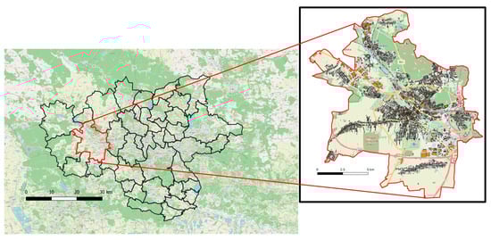
Figure 4.
The boundaries of the area of analysis.
The city of Gliwice is also characterized by a large area. In addition to the densely built-up central part, there are also suburban districts with single-family housing. Numerous important facilities are located in Gliwice, such as cultural and recreational objects and the biggest university of technology in the Silesian region.
The next step in the first stage of the analysis was to establish the number of new locations for EVCSs that should be determined. The number was assumed to be equal to five.
The second stage of the analysis was to divide the area under study into basic fields. Hexagonal basic fields were selected. The distance between the parallel sides of each hexagon was 300 m. This value was chosen based on the assumption that EV users leave their vehicles at charging stations and then walk to their destinations. Therefore, the size of the hexagon accounted for the distance that people are willing to walk. The hexagonal grid was overlayed on the Gliwice area, and the resulting division is presented in Figure 5.
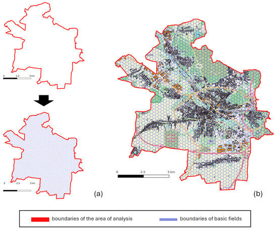
Figure 5.
The spatial division of the area: (a) the division of the area into hexagonal basic fields, (b) the hexagonal grid on the background of land use in Gliwice.
Subsequently, set which contains the numbers of hexagons in the area under study, and sets and for each hexagon were created. The area of Gliwice was divided into 1890 hexagonal basic fields.
The third stage was the identification of existing locations for EVCSs in the area. These locations are presented in Figure 6.
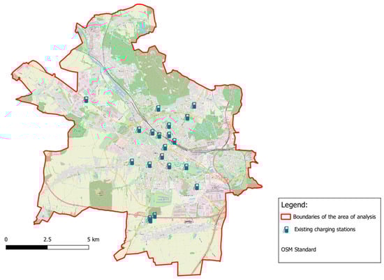
Figure 6.
Identification of the existing locations of EVCSs in the area.
In total, 20 existing EVCSs were identified in Gliwice, according to []. They are located mostly in the central part of the city, and a few operate in the suburban areas, mainly in the vicinity of large shopping centers. The existing EVCSs differ in terms of the types of chargers in use; however, the selection of the types of these devices is outside the scope of this study. Therefore, detailed features of the chargers were not analyzed. Subsequently, a set of numbers of hexagons in which the existing EVCSs are located as well as sets and , containing numbers of hexagons in the first and second levels of the neighborhood for all hexagons in which the existing EVCSs are located were obtained. The basic fields from sets , and are presented in Figure 7.
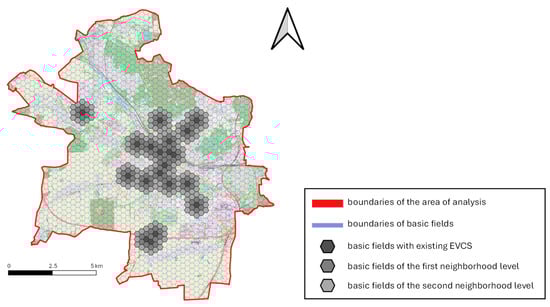
Figure 7.
Basic fields with existing EVCSs and basic fields of the 1st and 2nd levels of the neighborhood.
According to the assumptions of the proposed method, all basic fields from sets , , and were excluded from the consideration as fields where new EVCS could be located.
The fourth stage of the method was to estimate the potential of the basic fields for the new locations for EVCSs. This potential was estimated for all hexagons except for the basic fields from sets and .
The potential of each hexagon was determined based on the characteristics of the selected types of built-environment objects. The specific elements of the sets of objects for each group are presented in Table 3.
Table 3.
Elements of the sets considered in the analysis.
In the case of group , i.e., objects related to residential buildings, the total area of these objects was taken into account to calculate the potential for each field. However, in the case of group , i.e., objects related to public transport, and group , i.e., objects related to public utility facilities, only the presence of these types of objects was considered (binary variable taking the value 0 or 1).
After performing the necessary calculations, the potential for all basic fields of set was obtained. In total, set included the numbers of 1625 basic fields.
In the case of 565 basic fields, there were no built-environment objects from groups –; therefore, the potential for the location of the new ECVS in these fields was equal to 0. The number of basic fields in the selected ranges of values of potential is presented in Table 4. The maximum value of the potential was 2.93, and it was the only basic field with a value of potential higher than 2.5.
Table 4.
Distribution of basic fields in selected value ranges of the potential for a location of the new ECVS.
In the fifth stage of the proposed method, the basic fields recommended for new locations for EVCSs were determined using an iterative procedure. The number of steps in the procedure was equal to . The results of the procedure and the selection of the basic fields recommended for the locations of the new EVCSs in Gliwice are presented in Figure 8.
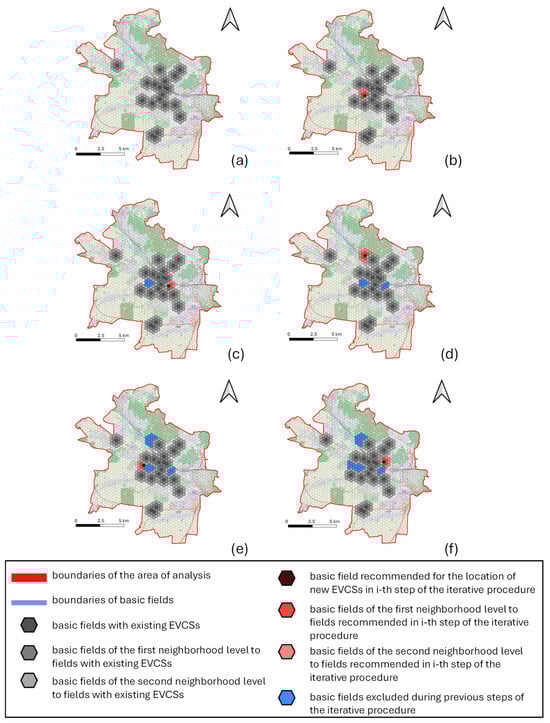
Figure 8.
Results of the iterative procedure for selecting basic fields recommended for the locations of new EVCSs: (a) state before the application of the iterative procedure, (b) 1st step of the iterative procedure, (c) 2nd step of the iterative procedure, (d) 3rd step of the iterative procedure, (e) 4th step of the iterative procedure, and (f) 5th step of the iterative procedure.
In each step of the procedure, one recommended basic field was selected, based on the highest value of potential and sets of basic fields of the first and second neighborhood levels for these basic fields were created. All these basic fields were then excluded from consideration in the following steps of the iterative procedure.
5. Discussion of the Results
An overview of the recommended fields for the locations of new EVCSs in the area under study is presented in Figure 9.
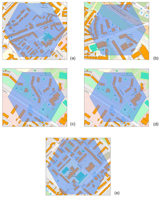
Figure 9.
Overview of recommended basic fields: (a) basic field chosen during the 1st step of the iterative procedure, (b) basic field chosen during the 2nd step of the iterative procedure, (c) basic field chosen during the 3rd step of the iterative procedure, (d) basic field chosen during the 4th step of the iterative procedure, and (e) basic field chosen during the 5th step of the iterative procedure.
The hexagonal basic field chosen in the first step of the iterative procedure is located in the central part of the city. It is characterized by dense development with the following functions: residential buildings, educational buildings, and public facilities. The basic field selected in the second step of the iterative procedure contains the buildings of the Silesian University of Technology, the largest technical university in the Silesian region. The basic fields chosen in the third and fourth steps of the procedure are characterized by large areas of residential buildings, mostly multi-floor houses. Finally, the basic field selected in the fifth step of the procedure is located in a densely populated area, and there are educational buildings located within its boundaries. The detailed results for these final locations for new EVCSs are provided in Table 5.
Table 5.
Main characteristics of the recommended locations for EVCSs.
The values of potential for the recommended basic fields range from 2.0 to 2.93. These fields are located mainly in the outer parts of the central district of Gliwice. In all the indicated locations, there is a relatively high level of residential development. The highest density of residents is in the location selected in the third step of iteration (the value is equal to 1.0). It is also worth noting that not all selected locations have public transport infrastructure (the value is equal to 0.0 for the locations selected in the second and third step of the iterative procedure). Similarly, based on the available data, no public utility facilities are found in the hexagon selected in the fourth iteration (the value is equal to 0.0).
The results presented allowed us to confirm the hypothesis that the potential of the location for a new and publicly accessible EVCS can be assessed based on the features of the built environment. The potential was calculated for each basic field in the area under study and—on this basis—conclusions regarding the proposed locations for the EVCSs were formulated.
The performed analysis also allowed us to answer the first research question and to create a set of built-environment object types that should be considered in the process of estimating potential. That set contains objects from the following three main groups: objects related to residential buildings, objects related to public transport, and objects related to public utility facilities.
The introduction of two neighborhood levels of basic fields allowed us to determine new locations for EVCSs that are evenly distributed in space in such a way that ensured their equal accessibility for users and answered the second research question. The presented approach also differs from other methods, as it leads to the exclusion of basic fields that are characterized by high potential but do not allow for a uniform distribution of EVCSs in the studied area. Nevertheless, it is important to point out that such a basic field can still be included when all stations are equally distributed to increase the density of EVCSs in a given area and provide even better conditions for users.
Determining appropriate locations for EV charging stations is particularly difficult because of the multifaceted nature of this issue, as complex legal, financial, technological, and organizational aspects must be considered []. This article presents a five-step approach to determining the locations for electric vehicle charging stations in an urban area, which takes into account the following three factors related to spatial development: the presence of residential buildings, connection to the public transport system, and access to selected public facilities. These factors are related to the directions of sustainable transport development [,,,,,,,,]. The proposed method may assist local authorities in making decisions on new locations for charging stations in the case of limited financial resources.
The developed model also has some limitations in its application. The accuracy of the location is determined by the basic field. Therefore, it depends on the size of this field. In addition, the proposed algorithm gives very high priority to the even distribution of charging stations, thus ensuring equal access to the charging infrastructure for all residents and users of EVs. At the same time, it does not verify the technical possibilities of building infrastructure, obtaining appropriate connection capacities, or administrative permits in a given area. Therefore, further analysis in the context of the practical application of the method is necessary, and these issues should be included in the constraints of the model.
Moreover, in a situation where the number of new locations for EVCSs to be determined is greater than the maximum number of possible (and justified) hexagons to be used, we can assume that the condition of s uniform distribution is met. It is then worth including the hexagons located on the second level of the neighborhood in the analysis. In the next step, hexagons on the first neighborhood level can also be included, gradually densifying the network of EVCSs. It is also necessary to define the constraints on the reasonable designation of new proposed locations for EVCSs. One idea could be to determine the required minimum level of potential for a given hexagon, below which new locations will no longer be proposed (e.g., hexagons located in the middle of green areas).
There are also potential limitations when using the method in countries other than Poland. The proposed method requires detailed data on the built environment. These data are easily accessible for Polish cities with the use of national databases. In different countries, spatial data could be inconsistent with Polish standards. Therefore, it is necessary to conduct research to facilitate the use of the method in different countries.
Previous studies also included dividing the area into basic fields to evaluate their potential for locating new EVCSs. In [], the authors assessed the potential of hexagonal basic fields; however, they used different variables related to the population in each hexagon and traffic characteristics. They also considered the influence of existing EVCSs in the area. The case study presented in this article was prepared for a different city and a different country, but we investigated how the new EVCSs were spatially distributed as one of the results of our analysis. The results obtained by the authors of the other study suggested that new EVCSs should be equally distributed, also in the basic fields close to the edges of the area under study. Our results, on the other hand, suggested locating new EVCSs closer to the city center. However, it is important to keep in mind that this could be caused by differences in the characteristics of the built environment in each city.
In [], the authors also used hexagonal-shaped basic fields. However, their approach was quite different because the authors divided the analysis into two stages as follows: macroscopic, to assess potentials in larger administrative units, and microscopic, to choose basic fields in which EVCSs should be located. The potential was calculated based on the number of registered electric vehicles, average income, and selected features associated with the built environment.
The method presented in this study is universal, which means that it can also be applied in other geographical locations and urban areas with different residential developments. In the case of other public utility facilities, set containing numbers of these types of objects can be modified to take into account the specificity of the given area. The resolution of the hexagonal grid can also be adjusted for the access to EVCSs acceptable to their users, which is mainly related to their travel behavior.
6. Conclusions
The application of the proposed method allowed us to determine a set of five basic fields in Gliwice, which are characterized by the highest values of potential for new locations for EVCSs. These basic fields contain built-environment objects that have a positive impact on the potential, and they also fulfill the requirement of the uniform spatial distribution of basic fields to ensure equal access to EVCSs.
An important result of the performed analysis was answering two research questions. The first research question pertained to the factors associated with the features of the built environment, which can effectively represent the actual potential of the new locations for EVCSs. During the analysis, it was determined that built-environment objects of three main groups should be considered in the method, i.e., objects related to residential buildings, objects related to public transport, and objects related to public utility facilities. The first group contains single-family housing, double-family housing, and multi-family housing. In the case of the second group, these objects include railway stations or stops, bus stations, interchange centers, and public transport stops. The last group contains the widest set of objects that concern generally understood public utility facilities such as kindergartens, primary schools, secondary schools, and universities, as well as hospitals, cinemas, theatres, museums, zoos, post offices, sports and recreational facilities, city halls, and local government buildings. The second research question referred to the spatial distribution of new EVCSs to provide equitable access to them. During the analysis, two levels of the neighborhood of basic fields were created, which allowed us to fulfill that requirement.
The proposed model requires further work and development. The next steps need to include the option of densifying EVCSs in the basic fields on the first and second levels of the neighborhood, as well as in the fields with existing charging stations. The extended model could also be used to determine the specific number of chargers within each station. The use of GIS data in this model also provides the possibility of a preliminary assessment of the conditions on the side of the power network.
Another direction of future studies includes the development of dedicated software that facilitates the calculations and the entire process of applying the proposed method. Such software could be especially useful in the case of large areas and when a large number of charging stations are to be located.
It is also necessary to consider different methods of dividing the area under study in future research. Although the hexagonal grid offers significant positive features, it could also be beneficial to consider, for example, the Voronoi diagram.
Future studies should also be conducted on the behavior and trends among users of EVCSs. In particular, this would involve taking into account data such as charging frequencies, charging times, and length of charging sessions, which could be specified for different types of facilities or types of urban areas. The research could show when and how often users charge their vehicles as well as which charging patterns they prefer—charging at night, during working hours, or while shopping. In addition, the length of the charging session could illustrate whether users prefer fast charging to cover a given distance or whether full charging is more popular. Analyzing such aspects could improve the efficient planning and optimization of new locations for EVCSs in future studies.
Author Contributions
Conceptualization, P.S., M.L., P.F. and R.Ż.; methodology, P.S., M.L., P.F. and R.Ż.; software, P.S.; validation, P.S. and R.Ż.; investigation, P.S., M.L., P.F. and R.Ż.; resources, P.S., M.L. and P.F.; data curation, P.S.; writing—original draft preparation, P.S., M.L., P.F. and R.Ż.; writing—review and editing, P.S., M.L., P.F. and R.Ż.; visualization, P.S., M.L., P.F. and R.Ż.; supervision, R.Ż.; project administration, P.S., M.L., P.F. and R.Ż.; funding acquisition, M.L. All authors have read and agreed to the published version of the manuscript.
Funding
This article is the result of work carried out under the Dean’s grant entitled: “Decision model for route planning in road transport of oversize loads, taking into account risk minimization aspects” awarded in November 2023. The grant was financed by the Dean of the Faculty of Transport of the Warsaw University of Technology. Number of the awarded grant: 1/WT/2023.
Data Availability Statement
The raw data supporting the conclusions of this article will be made available by the authors on request.
Conflicts of Interest
The authors declare no conflicts of interest.
Appendix A
- Notation:
| , , | —Class of the -th hexagon concerning the characteristics, respectively, , , and ; |
| —Matrix containing the values of the function with the interpretation related to the residential buildings of the -type in the -th hexagon; | |
| —The aggregated value of characteristics for all types of objects in the set for the -th hexagon; | |
| —Matrix containing the values of the function with the interpretation related to the presence of facilities of public transport of the -type in the -th hexagon; | |
| —The aggregated value of characteristics for all types of objects in the set for the -th hexagon; | |
| —Matrix containing the values of the function with the interpretation related to the presence of public utility facilities of the -type in the -th hexagon; | |
| —The aggregated value of characteristics for all types of objects in the set for the -th hexagon; | |
| —Set of hexagon numbers in the area under study; | |
| —Set of hexagon numbers of the first neighborhood level for the -th hexagon; | |
| —Set of hexagon numbers of the second neighborhood level for the -th hexagon; | |
| —Set of hexagon numbers in which the existing EVCSs are located; | |
| —Set of hexagon numbers of the first neighborhood level for all hexagons in which the existing EVCSs are located; | |
| —Set of hexagon numbers of the second neighborhood level for all hexagons in which the existing EVCSs are located; | |
| —Number of the hexagon with the highest value of potential for the new location of an EVCS in the -th iteration; | |
| —Set containing the numbers of hexagons considered for the new location of an EVCS in the -th iteration; | |
| —Set of hexagon numbers for which the potential for the new location of an EVCS is determined; | |
| —Set of hexagon numbers recommended for the new location of an EVCS in the -th iteration; | |
| —Iteration number; | |
| —Number of new locations of EVCSs to be determined; | |
| —The number of classes into which the ranges of variability in spatial development characteristics are divided; | |
| —The potential of a single -th hexagon for the new location of an EVCS without taking into account the potential of neighboring hexagons; | |
| —The potential of a single -th hexagon for the new location of an EVCS taking into account the potential of hexagons located at the first level of the neighborhood; | |
| —Ranges of the characteristics included in the matrices, respectively, , , and ; | |
| —Estimation of the potential of the -th hexagon for the new location of an EVCS in terms of characteristics, respectively, , , and ; | |
| —Set containing the number of object types related to residential buildings taken into account when determining the potential of the hexagon for the new location of an EVCS; | |
| —Set containing the number of object types related to public transport taken into account when determining the potential of the hexagon for the new location of an EVCS; | |
| —Set containing the number of object types related to public utility facilities taken into account when determining the potential of the hexagon for the new location of an EVCS. |
- The algorithm of the proposed method is presented in Figure A1.
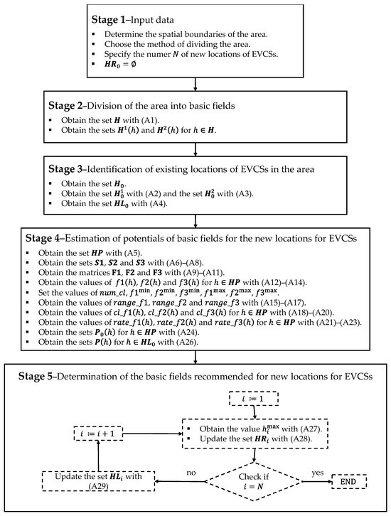
Figure A1.
The flowchart of the proposed method.
- STAGE 1—INPUT DATA
Among the input data, the most important are the following:
- The number of new locations for EVCSs to be established ();
- The spatial scope of the area that requires precise delineation of its boundaries.
- Moreover, in this stage, the size and shape of the basic fields should also be determined.
In this stage, the set of numbers of basic fields recommended for new locations of EVCSs is empty, i.e., .
- STAGE 2—DIVISION OF THE AREA INTO BASIC FIELDS
By dividing the space of the area under study into basic fields, we obtain a set of hexagons with specific numbers, which is written as follows:
where denotes the size of the set , i.e., the number of all hexagons in the area.
Then, for each hexagon the sets of hexagon numbers of the first and second levels of the neighborhood are determined according to the principle presented in Figure 2. These sets are marked as and , respectively.
- STAGE 3—IDENTIFICATION OF THE EXISTING LOCATIONS OF EVCS IN THE AREA
In this stage, the locations of the existing EVCSs in the area under study are identified and assigned to the hexagons in which they are located. In this way, the set , which contains hexagons with the existing locations of EVCSs, is built.
Then, sets and , containing, respectively, the hexagon numbers of the first and second neighborhood levels for all , are determined according to the formulas:
Basic fields that are elements of the sets , and are not considered for new locations of EVCSs. Therefore, the initial set, , which contains hexagon numbers in which new locations for EVCSs are considered, is defined as follows:
- STAGE 4—ESTIMATION OF POTENTIALS OF BASIC FIELDS FOR THE NEW LOCATIONS OF EVCSs
When estimating the potential of basic fields for new locations of EVCSs, hexagons creating the first level of the neighborhood are also taken into account. Therefore, set , which contains the hexagon numbers for which the characteristics are used to estimate the potential of hexagon , is defined as follows:
The potential of a single hexagon is determined based on the characteristics of various types of objects classified into three main groups as follows:
- Group 1—objects related to residential buildings;
- Group 2—objects related to public transport;
- Group 3—objects related to public utility facilities.
Therefore, three sets containing the numbers of object types taken into account when determining the potential of basic fields for the new locations of EVCSs are defined as follows:
where , , and denote the number of object types in a given group (i.e., the sizes of the sets , and ), respectively.
For each group of object types, one characteristic is selected as an additive variable, which can be determined for each basic field quantitatively for all types defined within each group. For the group of object types included in set the characteristic with the interpretation of the residential development area, taking into account the number of floors of objects of type in the hexagon is determined. For set the characteristic related to the presence of public transport objects of type in the hexagon is chosen, and for the group the characteristic identifying the presence or absence of an object of type in the hexagon is chosen. The values of these functions are arranged in matrix form as follows:
To determine the potential of the basic field for the new location of an EVCS, the aggregated values of the characteristics defined by Formulas (A9)–(A11) are determined for each hexagon as follows:
The parameter means the number of classes into which the range of variability in each variable determined by Formulas (A12)–(A14) is divided. This number is the same for all characteristics. The class ranges for individual characteristics are as follows:
where the minimum values , , and and the maximum values , , and are determined based on the assumed variability of each characteristic.
Determining the range of classes for individual characteristics allows for the allocation of a hexagon to classes , and , respectively, according to the following rule:
For the values , and that do not meet the conditions indicated in Formulas (A18)–(A20), no classification is carried out. Then, each hexagon is rated by , and respectively, depending on the class assigned for a given characteristic according to the following rule:
The potential of a single basic field without taking into account the potential of neighboring fields is marked as and determined according to the formula:
where , and denote the weights adopted for individual groups of object types, with:
The potential of a single basic field, taking into account the potential of hexagons located at its first level of the neighborhood, which is the basis for determining the set of hexagon numbers recommended for new locations for EVCSs, is determined as follows:
- STAGE 5—DETERMINATION OF THE BASIC FIELDS RECOMMENDED FOR NEW LOCATIONS OF EVCSs
Step 5 contains an iterative procedure with the number of steps equal to , corresponding to the number of new locations of EVCSs to be determined. In each -th iteration, the following actions are performed:
- Selecting the hexagon number with the highest potential value from the set of hexagon numbers according to the rule:
- Updating the set of that contains the hexagon numbers recommended for the new locations of EVCSs with the basic field number , i.e.,:
- Updating the set , which contains the numbers of basic fields in which new locations of EVCSs are considered in the next iteration; removing the hexagon number along with the hexagon numbers of its first and second levels of the neighborhood from the set , which can be expressed as follows:
The algorithm is completed after iterations, giving the output set containing the hexagon numbers in which new locations for EVCSs are recommended.
References
- IEA. Global EV Outlook 2024; IEA: Paris, France, 2024; Available online: https://www.iea.org/reports/global-ev-outlook-2024 (accessed on 7 June 2024).
- Altenburg, T.; Bhasin, S.; Fischer, D. Sustainability-Oriented Innovation in the Automobile Industry: Advancing Electromobility in China, France, Germany and India. Innov. Dev. 2012, 2, 67–85. [Google Scholar] [CrossRef]
- Calvo-Jurado, C.; Ceballos-Martínez, J.M.; García-Merino, J.C.; Muñoz-Solano, M.; Sánchez-Herrera, F.J. Optimal location of electric vehicle charging stations using proximity diagrams. Sustain. Cities Soc. 2024, 113, 105719. [Google Scholar] [CrossRef]
- Ademulegun, O.O.; MacArtain, P.; Oni, B.; Hewitt, N.J. Multi-Stage Multi-Criteria Decision Analysis for Siting Electric Vehicle Charging Stations within and across Border Regions. Energies 2022, 15, 9396. [Google Scholar] [CrossRef]
- Skaloumpakas, P.; Spiliotis, E.; Sarmas, E.; Lekidis, A.; Stravodimos, G.; Sarigiannis, D.; Makarouni, I.; Marinakis, V.; Psarras, J. A Multi-Criteria Approach for Optimizing the Placement of Electric Vehicle Charging Stations in Highways. Energies 2022, 15, 9445. [Google Scholar] [CrossRef]
- Morocho-Chicaiza, W.; Barragán-Escandón, A.; Zalamea-León, E.; Ochoa-Correa, D.; Terrados-Cepeda, J.; Serrano-Guerrero, X. Identifying locations for electric vehicle charging stations in urban areas through the application of multicriteria techniques. Energy Rep. 2024, 12, 1794–1809. [Google Scholar] [CrossRef]
- Neumeier, S.; Osigus, T. Germany’s Public EV Charging Points: Analysing the 2023 State of Expansion. Geogr. J. 2024, 190, e12570. [Google Scholar] [CrossRef]
- Machado, C.A.S.; Takiya, H.; Yamamura, C.L.K.; Quintanilha, J.A.; Berssaneti, F.T. Placement of Infrastructure for Urban Electromobility: A Sustainable Approach. Sustainability 2020, 12, 6324. [Google Scholar] [CrossRef]
- Ermagun, A.; Tian, J. Charging into Inequality: A National Study of Social, Economic, and Environment Correlates of Electric Vehicle Charging Stations. Energy Res. Soc. Sci. 2024, 115, 103622. [Google Scholar] [CrossRef]
- Min, Y.; Lee, H.W. Social Equity of Clean Energy Policies in Electric-Vehicle Charging Infrastructure Systems; ASCE: Reston, VA, USA, 2020; pp. 221–229. [Google Scholar]
- Çelik, S.; Ok, Ş. Electric vehicle charging stations: Model, algorithm, simulation, location, and capacity planning. Heliyon 2024, 10, e29153. [Google Scholar] [CrossRef]
- Szterlik-Grzybek, P.; Kucharski, A. Assessment of the Possibility of Locating Electric Car Charging Stations Using Fuzzy AHP and GIS—The Case of Łódź, Poland. Econ. Environ. 2023, 84, 134–148. [Google Scholar] [CrossRef]
- Gazmeh, H.; Guo, Y.; Qian, X. Understanding the Opportunity-Centric Accessibility for Public Charging Infrastructure. Transp. Res. Part D Transp. Environ. 2024, 131, 104222. [Google Scholar] [CrossRef]
- Iravani, H. A Multicriteria GIS-Based Decision-Making Approach for Locating Electric Vehicle Charging Stations. Transp. Eng. 2022, 9, 100135. [Google Scholar] [CrossRef]
- Charly, A.; Thomas, N.J.; Foley, A.; Caulfield, B. Identifying Optimal Locations for Community Electric Vehicle Charging. Sustain. Cities Soc. 2023, 94, 104573. [Google Scholar] [CrossRef]
- Zhao, H.; Gao, J.; Cheng, X. Electric Vehicle Solar Charging Station Siting Study Based on GIS and Multi-Criteria Decision-Making: A Case Study of China. Sustainability 2023, 15, 10967. [Google Scholar] [CrossRef]
- Yi, Z.; Liu, X.C.; Wei, R. Electric Vehicle Demand Estimation and Charging Station Allocation Using Urban Informatics. Transp. Res. Part D Transp. Environ. 2022, 106, 103264. [Google Scholar] [CrossRef]
- Rabl, R.; Reuter-Oppermann, M.; Jochem, P.E.P. Charging Infrastructure for Electric Vehicles in New Zealand. Transp. Policy 2024, 148, 124–144. [Google Scholar] [CrossRef]
- Zhang, H.; Shi, F. A Multi-Objective Site Selection of Electric Vehicle Charging Station Based on NSGA-II. Int. J. Ind. Eng. Comput. 2024, 15, 293–306. [Google Scholar] [CrossRef]
- He, S.Y.; Kuo, Y.-H.; Sun, K.K. The Spatial Planning of Public Electric Vehicle Charging Infrastructure in a High-Density City Using a Contextualised Location-Allocation Model. Transp. Res. Part A Policy Pract. 2022, 160, 21–44. [Google Scholar] [CrossRef]
- Gong, Y.; Kim, I. Optimization and Observation of EV Charging Station Deployment in the Republic of Korea: An Analysis of the Charging History and Correlation With Socioeconomic Factors. IEEE Access 2024, 12, 68285–68302. [Google Scholar] [CrossRef]
- Qin, J.; Qiu, J.; Chen, Y.; Wu, T.; Xiang, L. Charging Stations Selection Using a Graph Convolutional Network from Geographic Grid. Sustainability 2022, 14, 16797. [Google Scholar] [CrossRef]
- Jonas, T.; Daniels, N.; Macht, G. Electric Vehicle User Behavior: An Analysis of Charging Station Utilization in Canada. Energies 2023, 16, 1592. [Google Scholar] [CrossRef]
- Fu, J.; Nåbo, A.; Bhatti, H.J. Locating Charging Infrastructure for Freight Transport Using Multiday Travel Data. Transp. Policy 2024, 152, 21–28. [Google Scholar] [CrossRef]
- Csonka, B.; Csiszár, C. Determination of Charging Infrastructure Location for Electric Vehicles. Transp. Res. Procedia 2017, 27, 768–775. [Google Scholar] [CrossRef]
- Baresch, M.; Moser, S. Allocation of E-Car Charging: Assessing the Utilization of Charging Infrastructures by Location. Transp. Res. Part A Policy Pract. 2019, 124, 388–395. [Google Scholar] [CrossRef]
- K, V.S.M.B.; Chakraborty, P.; Pal, M. Planning of Fast Charging Infrastructure for Electric Vehicles in a Distribution System and Prediction of Dynamic Price. Int. J. Electr. Power Energy Syst. 2024, 155, 109502. [Google Scholar] [CrossRef]
- Prakobkaew, P.; Sirisumrannukul, S. Optimal Locating and Sizing of Charging Stations for Large-Scale Areas Based on GIS Data and Grid Partitioning. IET Gener. Transm. Distrib. 2024, 18, 1235–1254. [Google Scholar] [CrossRef]
- Kandil, S.M.; Abdelfatah, A.; Azzouz, M.A. Optimization Approaches for Fast Charging Stations Allocation and Sizing: A Review. IEEE Access 2024, 12, 46741–46763. [Google Scholar] [CrossRef]
- Kchaou-Boujelben, M. Charging Station Location Problem: A Comprehensive Review on Models and Solution Approaches. Transp. Res. Part C Emerg. Technol. 2021, 132, 103376. [Google Scholar] [CrossRef]
- Abdel-Basset, M.; Gamal, A.; Hezam, I.M.; Sallam, K.M. Sustainability Assessment of Optimal Location of Electric Vehicle Charge Stations: A Conceptual Framework for Green Energy into Smart Cities. Environ. Dev. Sustain. 2024, 26, 11475–11513. [Google Scholar] [CrossRef]
- Mehouachi, I.; Trojette, M.; Grayaa, K. MONNA: Multi-Objective Neural Network Algorithm for the Optimal Location of Electric Vehicle Charging Infrastructure in Tunis City. J. Clean. Prod. 2023, 431, 139837. [Google Scholar] [CrossRef]
- Foda, A.; Abdelaty, H.; Mohamed, M.; El-Saadany, E. A Generic Cost-Utility-Emission Optimization for Electric Bus Transit Infrastructure Planning and Charging Scheduling. Energy 2023, 277, 127592. [Google Scholar] [CrossRef]
- Tounsi Fokui, W.S.; Saulo, M.J.; Ngoo, L. Optimal Placement of Electric Vehicle Charging Stations in a Distribution Network With Randomly Distributed Rooftop Photovoltaic Systems. IEEE Access 2021, 9, 132397–132411. [Google Scholar] [CrossRef]
- Bian, H.; Zhou, C.; Guo, Z.; Wang, X.; He, Y.; Peng, S. Planning of Electric Vehicle Fast-Charging Station Based on POI Interest Point Division, Functional Area, and Multiple Temporal and Spatial Characteristics. Energy Rep. 2022, 8, 831–840. [Google Scholar] [CrossRef]
- Algafri, M.; Alghazi, A.; Almoghathawi, Y.; Saleh, H.; Al-Shareef, K. Smart City Charging Station Allocation for Electric Vehicles Using Analytic Hierarchy Process and Multiobjective Goal-Programming. Appl. Energy 2024, 372, 123775. [Google Scholar] [CrossRef]
- Fadranski, D.; Syré, A.M.; Grahle, A.; Göhlich, D. Analysis of Charging Infrastructure for Private, Battery Electric Passenger Cars: Optimizing Spatial Distribution Using a Genetic Algorithm. World Electr. Veh. J. 2023, 14, 26. [Google Scholar] [CrossRef]
- Mazur, M.; Dybała, J.; Kluczek, A. Suitable Law-Based Location Selection of High-Power Electric Vehicles Charging Stations on the TEN-T Core Network for Sustainability: A Case of Poland. Arch. Transp. 2024, 69, 75–90. [Google Scholar] [CrossRef]
- Regulation (EU) 2023/1804 of the European Parliament and of the Council of 13 September 2023 on the Deployment of Alternative Fuels Infrastructure, and Repealing Directive 2014/94/EU; Official Journal of the European Union L 234/1. Available online: https://eur-lex.europa.eu/legal-content/EN/TXT/PDF/?uri=CELEX:32023R1804 (accessed on 18 June 2024).
- Speth, D.; Sauter, V.; Plötz, P. Where to Charge Electric Trucks in Europe—Modelling a Charging Infrastructure Network. World Electr. Veh. J. 2022, 13, 162. [Google Scholar] [CrossRef]
- Luh, S.; Kannan, R.; McKenna, R.; Schmidt, T.J.; Kober, T. How, Where, and When to Charge Electric Vehicles—Net-Zero Energy System Implications and Policy Recommendations. Environ. Res. Commun. 2023, 5, 095004. [Google Scholar] [CrossRef]
- Radermecker, V.; Vanhaverbeke, L. Estimation of Public Charging Demand Using Cellphone Data and Points of Interest-Based Segmentation. World Electr. Veh. J. 2023, 14, 35. [Google Scholar] [CrossRef]
- Wu, R.; Wang, T.; Wang, Z.; Fang, Z.; Zhou, X.; Xu, N. Spatial Adaptability Evaluation and Optimal Location of Electric Vehicle Charging Stations: A Win-Win View from Urban Travel Dynamics. Energy Strategy Rev. 2023, 49, 101122. [Google Scholar] [CrossRef]
- Lopes, S.B.; Brondino, N.C.M.; Rodrigues da Silva, A.N. GIS-Based Analytical Tools for Transport Planning: Spatial Regression Models for Transportation Demand Forecast. ISPRS Int. J. Geo-Inf. 2014, 3, 565–583. [Google Scholar] [CrossRef]
- O’Sullivan, D.; Morrison, A.; Shearer, J. Using desktop GIS for the investigation of accessibility by public transport: An isochrone approach. Int. J. Geogr. Inf. Sci. 2000, 14, 85–104. [Google Scholar] [CrossRef]
- Żochowska, R.; Kłos, M.J.; Soczówka, P.; Pilch, M. Assessment of Accessibility of Public Transport by Using Temporal and Spatial Analysis. Sustainability 2022, 14, 16127. [Google Scholar] [CrossRef]
- Soldatke, N.; Sydorów, M.; Żukowska, S. Assessment of the accessibility of public transport in the Tricity (Poland): Analytical use of geographical information systems (GIS) in the context of selected public transport measures. Int. J. Digit. Earth 2024, 17, 2344586. [Google Scholar] [CrossRef]
- Żochowska, R.; Jacyna, M.; Kłos, M.J.; Soczówka, P. A GIS-Based Method of the Assessment of Spatial Integration of Bike-Sharing Stations. Sustainability 2021, 13, 3894. [Google Scholar] [CrossRef]
- Settou, B.; Settou, N.; Gouareh, A.; Negrou, B.; Mokhtara, C.; Messaoudi, D. GIS-based method for future prospect of energy supply in Algerian road transport sector using solar roads technology. Energy Procedia 2019, 162, 221–230. [Google Scholar] [CrossRef]
- Younes, A.; Mohamadi, B.; AbuGhazala, M.O. Terrorism in Egypt: A Comprehensive Spatial, Spatio-Temporal, and Statistical Analysis. GeoJournal 2023, 88, 6339–6364. [Google Scholar] [CrossRef]
- Soczówka, P.; Żochowska, R.; Karoń, G. Method of the Analysis of the Connectivity of Road and Street Network in Terms of Division of the City Area. Computation 2020, 8, 54. [Google Scholar] [CrossRef]
- Available online: https://www.plugshare.com/pl (accessed on 28 June 2024).
- Izdebski, M.; Jacyna, M.; Bogdański, J. Minimisation of the Energy Expenditure of Electric Vehicles in Municipal Service Companies, Taking into Account the Uncertainty of Charging Point Operation. Energies 2024, 17, 2179. [Google Scholar] [CrossRef]
- Jacyna, M.; Żochowska, R.; Sobota, A.; Wasiak, M. Decision support for choosing a scenario for organizing urban transport system with share of electric vehicles. Scientific Journal of Silesian University of Technology. Ser. Transp. 2022, 117, 69–89. [Google Scholar] [CrossRef]
- Mrozik, M.; Merkisz-Guranowska, A. Modeling of material and energy inputs in the life cycle of a vehicle. Arch. Transp. 2024, 70, 117–136. [Google Scholar] [CrossRef]
- Chamier Gliszczyński, N. Sustainable Operation of a Transport System in Cities. Key Eng. Mater. 2011, 486, 175–178. [Google Scholar] [CrossRef]
- Nosal, K.; Starowicz, W. Evaluation of influence of mobility management instruments implemented in separated areas of the city on the changes in modal split. Arch. Transp. 2015, 35, 41–52. [Google Scholar] [CrossRef]
- Chamier-Gliszczyński, N.; Bohdal, T. Mobility in Urban Areas in Environment Protection. Rocz. Ochr. Sr. 2016, 18, 387–399. [Google Scholar]
- Jacyna-Gołda, I.; Żak, J.; Gołębiowski, P. Models of traffic flow distribution for various scenarios of the development of proecological transport system. Arch. Transp. 2014, 4, 17–28. [Google Scholar] [CrossRef]
- Kierzkowski, A.; Tubis, A.A. Transportation Systems Modeling, Simulation and Analysis with Reference to Energy Supplying. Energies 2023, 16, 3586. [Google Scholar] [CrossRef]
- Kamińska, M.; Szymlet, N.; Fuć, P.; Rymaniak, Ł.; Lijewski, P.; Grzeszczyk, R. Analysis of harmful compounds concentrations in the exhaust behind a vehicle with compression ignition engine. Combust. Engines 2024, 197, 50–55. [Google Scholar] [CrossRef]
- Csiszar, C.; Csonka, B.; Foldes, D.; Wirth, E.; Lovas, T. Urban public charging station locating method for electric vehicles based on land use approach. J. Transp. Geogr. 2019, 74, 173–180. [Google Scholar] [CrossRef]
Disclaimer/Publisher’s Note: The statements, opinions and data contained in all publications are solely those of the individual author(s) and contributor(s) and not of MDPI and/or the editor(s). MDPI and/or the editor(s) disclaim responsibility for any injury to people or property resulting from any ideas, methods, instructions or products referred to in the content. |
© 2024 by the authors. Licensee MDPI, Basel, Switzerland. This article is an open access article distributed under the terms and conditions of the Creative Commons Attribution (CC BY) license (https://creativecommons.org/licenses/by/4.0/).