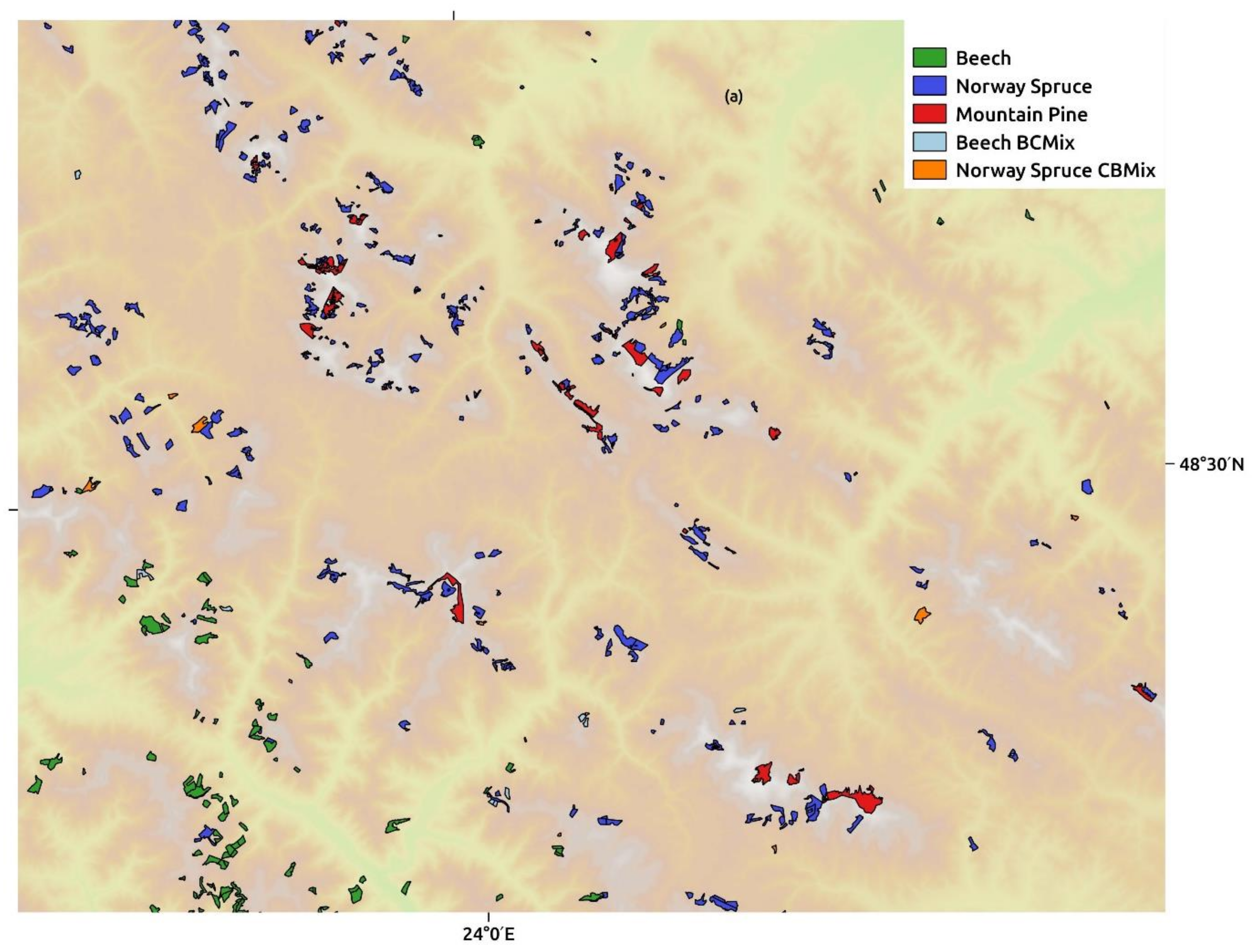
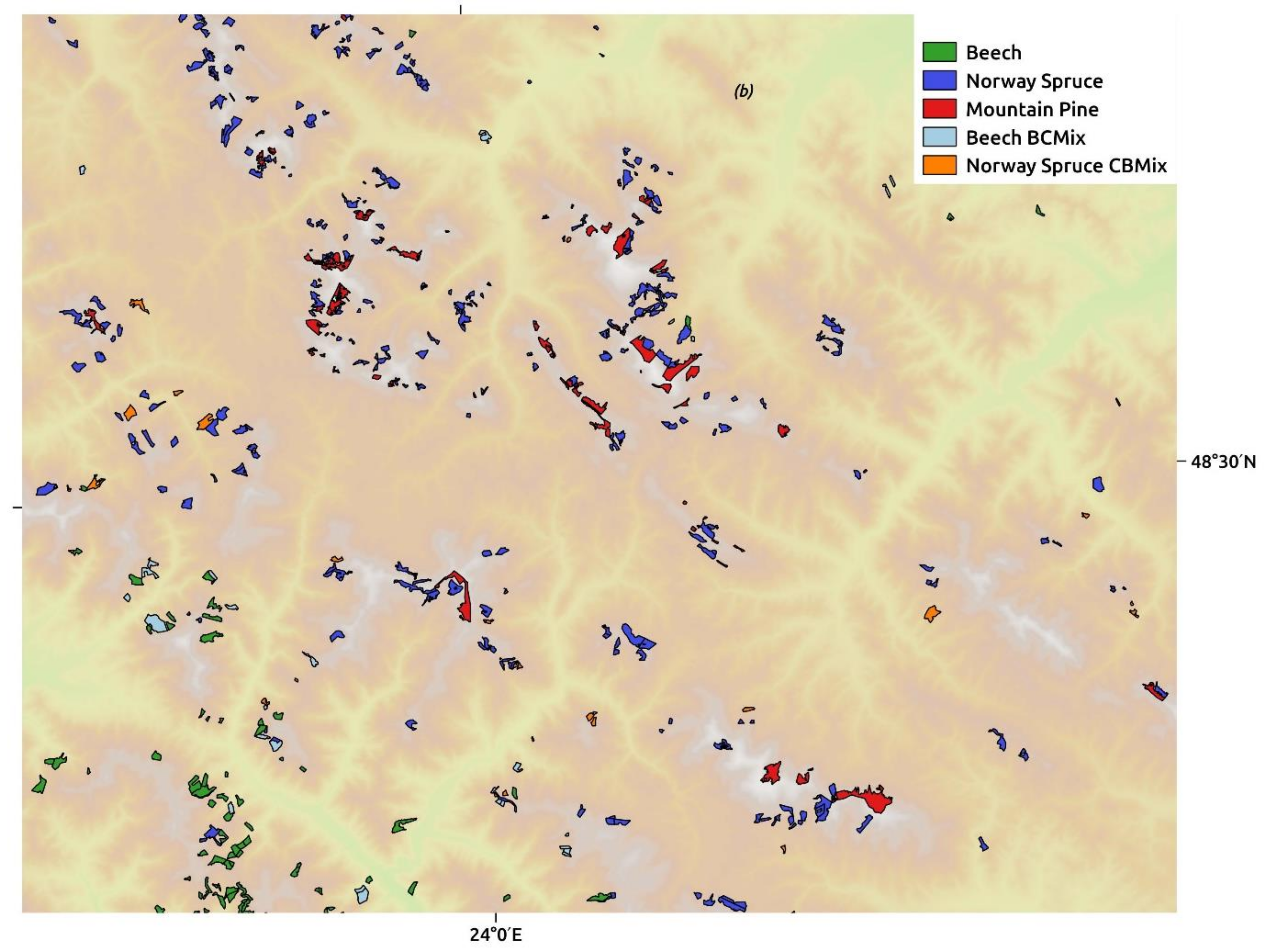
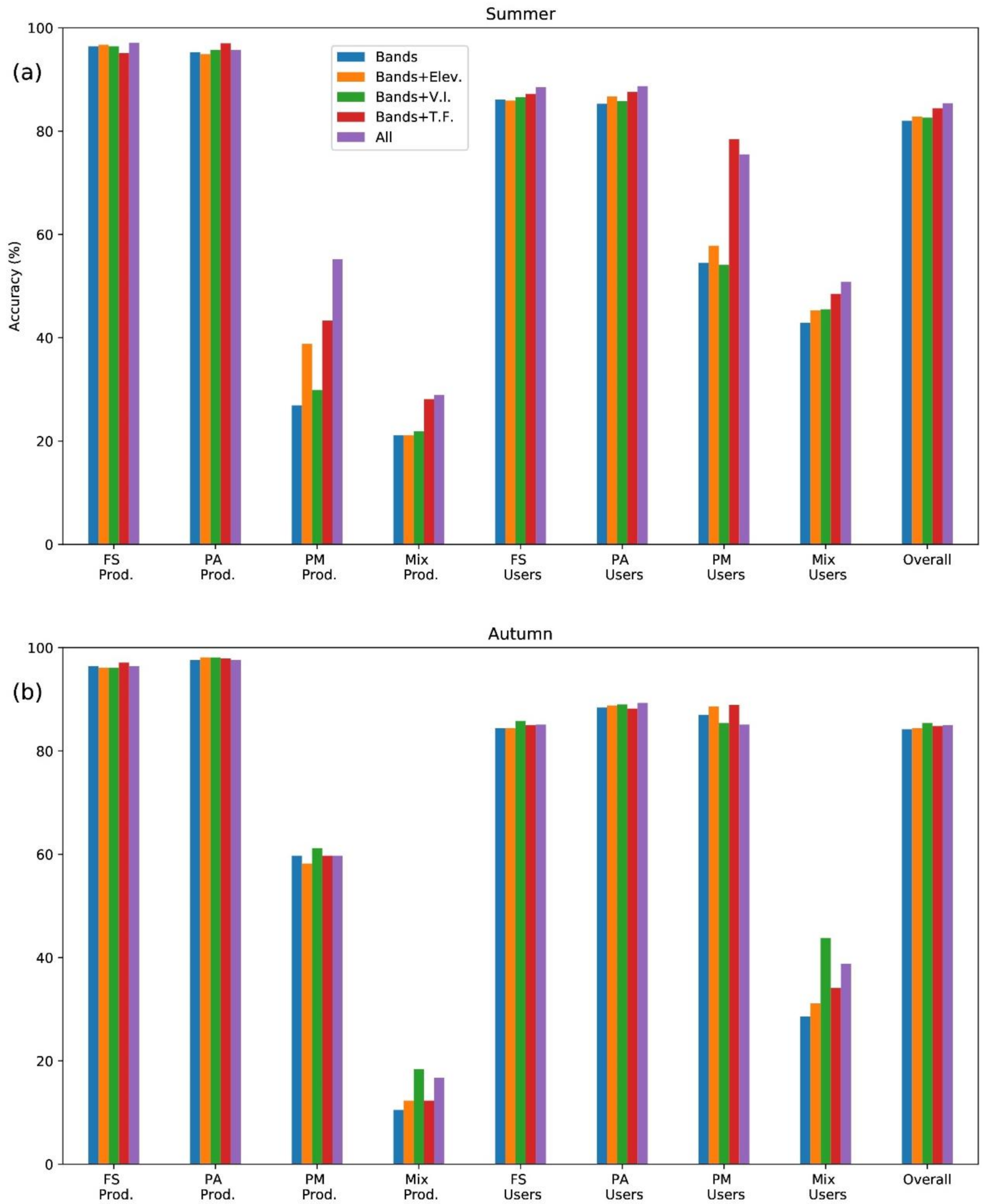
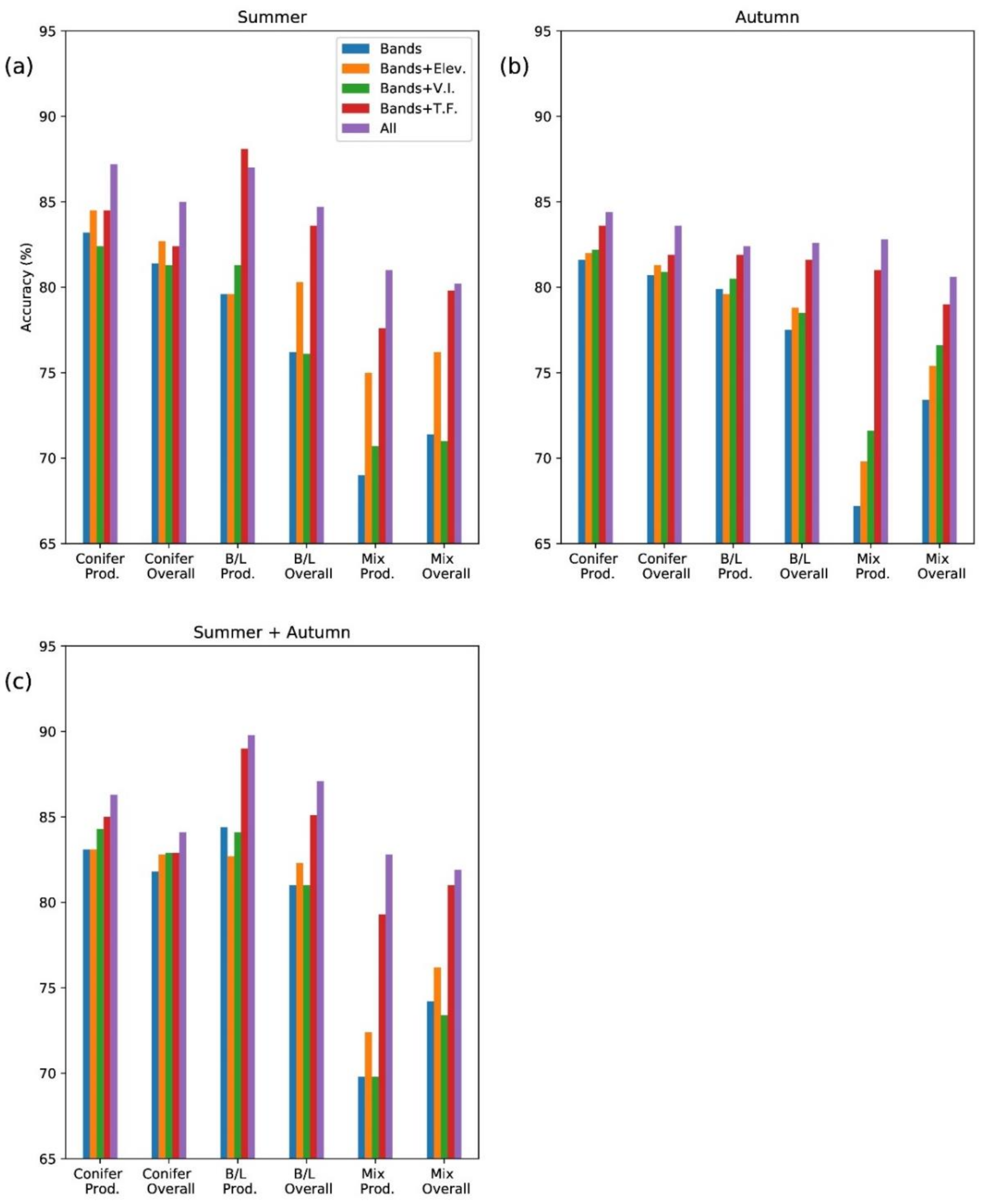
Identifying European Old-Growth Forests using Remote Sensing: A Study in the Ukrainian Carpathians
Abstract
:1. Introduction
- Use machine learning (Random Forest classification) to identify different tree species in OGF.
- Determine if Random Forest classification can be used to identify and map potential OGF sites by differentiating between OGF and other forest types.
- Determine how combinations of spectral bands, multitemporal imagery and ancillary data affect map accuracy.
2. Material and Methods
2.1. Study Site
2.2. OGF Survey Data
- standing and lying dead wood;
- complex structure (high variety of age groups and tree sizes);
- no non-native tree species;
- no visible traces of exploitation—i.e., logging.
2.3. Sentinel-2 Images
- “S2B_MSIL1C_20170802T092029_N0205_R093_T34UGU_20170802T092027.SAFE” and
- “S2A_MSIL1C_20171016T092031_N0205_R093_T34UGU_20171016T092425.SAFE” respectively.
2.4. Sentinel-2 Image Evaluation
2.5. Random Forest Method
3. Results and Discussion
3.1. Distinguishing Old-Growth Forest Tree Species
3.2. Distinguishing between OGF and non-OGF
4. Conclusions
Supplementary Materials
Author Contributions
Funding
Acknowledgments
Conflicts of Interest
References
- Merce, O.; Borlea, G.F.; Turcu, D.O. Definitions and structural attributes of the ecosystems from natural forests-short review. J. Hortic. For. Biotechnol. 2014, 18, 114–120. [Google Scholar]
- Wirth, C.; Messier, C.; Bergeron, Y.; Frank, D.; Fankhänel, A. Old-growth forest definitions: A pragmatic view. Wirth, C., Gleixner, G., Heimann, M., Eds.; In Old-Growth Forests; Springer: Berlin/Heidelberg, Germany, 2009; Volume 207, pp. 11–33. [Google Scholar]
- Burrascano, S.; Keeton, W.S.; Sabatini, F.M.; Blasi, C. Commonality and variability in the structural attributes of moist temperate old-growth forests: A global review. For. Ecol. Manag. 2013, 291, 458–479. [Google Scholar] [CrossRef]
- Paillet, Y.; Bergès, L.; Hjältén, J.; Ódor, P.; Avon, C.; Bernhardt-Römermann, M.; Bijlsma, R.-J.; De Bruyn, L.U.C.; Fuhr, M.; Grandin, U.L.F.; et al. Biodiversity differences between managed and unmanaged forests: Meta-analysis of species richness in Europe. Conserv. Biol. 2010, 24, 101–112. [Google Scholar] [CrossRef] [PubMed]
- Granata, M.U.; Gratani, L.; Bracco, F.; Sartori, F.; Catoni, R. Carbon stock estimation in an unmanaged old-growth forest: A case study from a broad-leaf deciduous forest in the Northwest of Italy. Int. For. Rev. 2016, 18, 444–451. [Google Scholar] [CrossRef]
- Jacob, M.; Bade, C.; Calvete, H.; Dittrich, S.; Leuschner, C.; Hauck, M. Significance of over-mature and decaying trees for carbon stocks in a Central European natural spruce forest. Ecosystems 2013, 16, 336–346. [Google Scholar] [CrossRef]
- Seedre, M.; Kopáček, J.; Janda, P.; Bače, R.; Svoboda, M. Carbon pools in a montane old-growth Norway spruce ecosystem in Bohemian Forest: Effects of stand age and elevation. For. Ecol. Manag. 2015, 346, 106–113. [Google Scholar] [CrossRef]
- Keeton, W.S.; Chernyavskyy, M.; Gratzer, G.; Main-Knorn, M.; Shpylchak, M.; Bihun, Y. Structural characteristics and aboveground biomass of old-growth spruce–fir stands in the eastern Carpathian mountains, Ukraine. Plant Biosyst. 2010, 144, 148–159. [Google Scholar] [CrossRef]
- Luyssaert, S.; Schulze, E.-D.; Börner, A.; Knohl, A.; Hessenmöller, D.; Law, B.E.; Ciais, P.; Grace, J. Old-growth forests as global carbon sinks. Nature 2008, 455, 213–215. [Google Scholar] [CrossRef]
- Frey, S.J.; Hadley, A.S.; Johnson, S.L.; Schulze, M.; Jones, J.A.; Betts, M.G. Spatial models reveal the microclimatic buffering capacity of old-growth forests. Sci. Adv. 2016, 2, e1501392. [Google Scholar] [CrossRef]
- Sabatini, F.M.; Burrascano, S.; Keeton, W.S.; Levers, C.; Lindner, M.; Pötzschner, F.; Verkerk, P.J.; Bauhus, J.; Buchwald, E.; Chaskovsky, O.; et al. Where are Europe’s last primary forests? Divers. Distrib. 2018, 24, 1426–1439. [Google Scholar] [CrossRef]
- Knorn, J.A.N.; Kuemmerle, T.; Radeloff, V.C.; Keeton, W.S.; Gancz, V.; BIRIŞ, I.-A.; Svoboda, M.; Griffiths, P.; Hagatis, A.; Hostert, P. Continued loss of temperate old-growth forests in the Romanian Carpathians despite an increasing protected area network. Environ. Conserv. 2013, 40, 182–193. [Google Scholar] [CrossRef]
- Dalponte, M.; Bruzzone, L.; Gianelle, D. Tree species classification in the Southern Alps based on the fusion of very high geometrical resolution multispectral/hyperspectral images and LiDAR data. Remote Sens. Environ. 2012, 123, 258–270. [Google Scholar] [CrossRef]
- Heinzel, J.; Koch, B. Investigating multiple data sources for tree species classification in temperate forest and use for single tree delineation. Int. J. Appl. Earth Obs. Geoinf. 2012, 18, 101–110. [Google Scholar] [CrossRef]
- Immitzer, M.; Atzberger, C.; Koukal, T. Tree species classification with random forest using very high spatial resolution 8-band WorldView-2 satellite data. Remote Sens. 2012, 4, 2661–2693. [Google Scholar] [CrossRef]
- Puletti, N.; Chianucci, F.; Castaldi, C. Use of Sentinel-2 for forest classification in Mediterranean environments. Ann. Silvic. Res. 2018, 42, 32–38. [Google Scholar]
- Sheeren, D.; Fauvel, M.; Josipović, V.; Lopes, M.; Planque, C.; Willm, J.; Dejoux, J.-F. Tree species classification in temperate forests using Formosat-2 satellite image time series. Remote Sens. 2016, 8, 734. [Google Scholar] [CrossRef]
- Leckie, D.G.; Tinis, S.; Nelson, T.; Burnett, C.; Gougeon, F.A.; Cloney, E.; Paradine, D. Issues in species classification of trees in old growth conifer stands. Can. J. Remote Sens. 2005, 31, 175–190. [Google Scholar] [CrossRef]
- Cohen, W.B.; Spies, T.A.; Fiorella, M. Estimating the age and structure of forests in a multi-ownership landscape of western Oregon, USA. Int. J. Remote Sens. 1995, 16, 721–746. [Google Scholar] [CrossRef]
- Cohen, W.B.; Spies, T.A. Estimating structural attributes of Douglas-fir/western hemlock forest stands from Landsat and SPOT imagery. Remote Sens. Environ. 1992, 41, 1–17. [Google Scholar] [CrossRef]
- Fiorella, M.; Ripple, W.J. Determining successional stage of temperate coniferous forests with Landsat satellite data. Photogramm. Eng. Remote Sens. 1993, 59, 239–246. [Google Scholar]
- Jiang, H.; Strittholt, J.R.; Frost, P.A.; Slosser, N.C. The classification of late seral forests in the Pacific Northwest, USA using Landsat ETM+ imagery. Remote Sens. Environ. 2004, 91, 320–331. [Google Scholar] [CrossRef]
- Sabol Jr, D.E.; Gillespie, A.R.; Adams, J.B.; Smith, M.O.; Tucker, C.J. Structural stage in Pacific Northwest forests estimated using simple mixing models of multispectral images. Remote Sens. Environ. 2002, 80, 1–16. [Google Scholar] [CrossRef]
- Sverdrup-Thygeson, A.; Ørka, H.O.; Gobakken, T.; Næsset, E. Can airborne laser scanning assist in mapping and monitoring natural forests? For. Ecol. Manag. 2016, 369, 116–125. [Google Scholar] [CrossRef]
- Kathmann, F.; Ciutea, A.; Biris, I.-A.; Ibisch, P.L.; Salageanu, V. Potential Primary Forests Map of Romania; Ibisch, P.L., Ursu, A., Eds.; Greenpeace CEE Romania; Centre for Econics and Ecosystem Management, Eberswalde University for Sustainable Development; Geography Department, A. I. Cuza University of Iași: Bucharest, Romania, 2017; Available online: https://www.researchgate.net/publication/321098644_Potential_Primary_Forests_Map_of_Romania_published_by_Greenpeace_CEE_Romania_Centre_for_Econics_and_Ecosystem_Management_Eberswalde_University_for_Sustainable_Development_Geography_Department_A_I_Cuza (accessed on 11 January 2018).
- Immitzer, M.; Vuolo, F.; Atzberger, C. First experience with Sentinel-2 data for crop and tree species classifications in central Europe. Remote Sens. 2016, 8, 166. [Google Scholar] [CrossRef]
- Forest Code of Ukraine (in Ukrainian). Available online: https://zakon.rada.gov.ua/go/3852-12 (accessed on 10 January 2019).
- Lavnyy, V.; Lässig, R. Extent of storms in the Ukrainian Carpathians. In Proceedings of the Proceedings of the International Conference on Wind Effects on Trees, University of Karlsruhe, Karlsruhe, Baden-Württemberg, Germany, 16–18 September 2003; pp. 16–18. [Google Scholar]
- Simpson, M. Determining the potential distribution of highly invasive plants in the Carpathian Mountains of Ukraine: A species distribution modeling approach under different climate-land-use scenarios and possible implications for natural-resource management. Environ. Sci. Policy 2011, 12. Available online: http://jhir.library.jhu.edu/handle/1774.2/35707 (accessed on 10 January 2019).
- Kozak, J.; Estreguil, C.; Troll, M. Forest cover changes in the northern Carpathians in the 20th century: A slow transition. J. Land Use Sci. 2007, 2, 127–146. [Google Scholar] [CrossRef]
- Kuemmerle, T.; Hostert, P.; Radeloff, V.C.; van der Linden, S.; Perzanowski, K.; Kruhlov, I. Cross-border comparison of post-socialist farmland abandonment in the Carpathians. Ecosystems 2008, 11, 614. [Google Scholar] [CrossRef]
- Kuemmerle, T.; Hostert, P.; Radeloff, V.C.; Perzanowski, K.; Kruhlov, I. Post-socialist forest disturbance in the Carpathian border region of Poland, Slovakia and Ukraine. Ecol. Appl. 2007, 17, 1279–1295. [Google Scholar] [CrossRef]
- Kuemmerle, T.; Chaskovskyy, O.; Knorn, J.; Radeloff, V.C.; Kruhlov, I.; Keeton, W.S.; Hostert, P. Forest cover change and illegal logging in the Ukrainian Carpathians in the transition period from 1988 to 2007. Remote Sens. Environ. 2009, 113, 1194–1207. [Google Scholar] [CrossRef]
- Complicit in Corruption. How billion-dollar firms and EU Governments are Failing Ukraine’s Forests (2018) Earthsight. Available online: https://docs.wixstatic.com/ugd/624187_673e3aa69ed84129bdfeb91b6aa9ec17.pdf (accessed on 10 January 2019).
- Irland, L.; Kremenetska, E. Practical economics of forest ecosystem management: The case of the Ukrainian Carpathians. Ecol. Econ. Sustain. For. Manag. Dev. Trans-Discip. Approach Carpathian Mt. Ukr. Natl. For. Univ. Press 2009, 59, 180–200. [Google Scholar]
- Sitko, I.; Troll, M. Timberline changes in relation to summer farming in the Western Chornohora (Ukrainian Carpathians). Mt. Res. Dev. 2008, 28, 263–271. [Google Scholar] [CrossRef]
- Trotsiuk, V.; Hobi, M.L.; Commarmot, B. Age structure and disturbance dynamics of the relic virgin beech forest Uholka (Ukrainian Carpathians). For. Ecol. Manag. 2012, 265, 181–190. [Google Scholar] [CrossRef]
- Trotsiuk, V.; Svoboda, M.; Janda, P.; Mikolas, M.; Bace, R.; Rejzek, J.; Samonil, P.; Chaskovskyy, O.; Korol, M.; Myklush, S. A mixed severity disturbance regime in the primary Picea abies (L.) Karst. forests of the Ukrainian Carpathians. For. Ecol. Manag. 2014, 334, 144–153. [Google Scholar] [CrossRef]
- Hobi, M.L.; Commarmot, B.; Bugmann, H. Pattern and process in the largest primeval beech forest of E urope (Ukrainian Carpathians). J. Veg. Sci. 2015, 26, 323–336. [Google Scholar] [CrossRef]
- Volosyanchuk, R.; Prots, B.; Kagalo, A.; Shparyk, Y.; Cherniavskyi, M.; Bondaruk, G. Criteria and Methology for Virgin and Old-Growth (Quasi-Virgin) Forest Identification; Volosyanchuk, R., Prots, B., Kagalo, A., Eds.; Liga Press: Lviv, Ukraine, 2017. Available online: http://d2ouvy59p0dg6k.cloudfront.net/downloads/old_growth_forest_identification_methodology.pdf (accessed on 1 December 2018).
- Roman Volosyanchuk Virgin and Old Growth Forests in Ukraine. Available online: http://www.carpathianconvention.org/tl_files/carpathiancon/Downloads/03%20Meetings%20and%20Events/Working%20Groups/Sustainable%20Forest%20Management/6th%20meeting/presentations/VF_for_CC_Sopron_WWF_UA.pdf (accessed on 11 January 2018).
- Hansen, M.C.; Potapov, P.V.; Moore, R.; Hancher, M.; Turubanova, S.A.; Tyukavina, A.; Thau, D.; Stehman, S.V.; Goetz, S.J.; Loveland, T.R.; et al. High-resolution global maps of 21st-century forest cover change. Science 2013, 342, 850–853. [Google Scholar] [CrossRef] [PubMed]
- Wulder, M.A.; Skakun, R.S.; Kurz, W.A.; White, J.C. Estimating time since forest harvest using segmented Landsat ETM+ imagery. Remote Sens. Environ. 2004, 93, 179–187. [Google Scholar] [CrossRef]
- Drusch, M.; Del Bello, U.; Carlier, S.; Colin, O.; Fernandez, V.; Gascon, F.; Hoersch, B.; Isola, C.; Laberinti, P.; Martimort, P. Sentinel-2: ESA’s optical high-resolution mission for GMES operational services. Remote Sens. Environ. 2012, 120, 25–36. [Google Scholar] [CrossRef]
- Louis, J.; Debaecker, V.; Pflug, B.; Main-Knorn, M.; Bieniarz, J.; Mueller-Wilm, U.; Cadau, E.; Gascon, F. Sentinel-2 Sen2Cor: L2A Processor for Users. In Proceedings of the Proceedings Living Planet Symposium 2016, Prague, Czech Republic, 9–13 May 2016; pp. 1–8. [Google Scholar]
- Clark, M.L.; Roberts, D.A.; Clark, D.B. Hyperspectral discrimination of tropical rain forest tree species at leaf to crown scales. Remote Sens. Environ. 2005, 96, 375–398. [Google Scholar] [CrossRef]
- Coburn, C.A.; Roberts, A.C. A multiscale texture analysis procedure for improved forest stand classification. Int. J. Remote Sens. 2004, 25, 4287–4308. [Google Scholar] [CrossRef]
- Zhaoa, P.; Zhaoa, J.; Wub, J.; Yanga, Y.; Xuea, W.; Houa, Y. Integration of multi-classifiers in object-based methods for forest classification in the Loess plateau, China. SCIENCEASIA 2016, 42, 283–289. [Google Scholar] [CrossRef]
- Haralick, R.M. Statistical and structural approaches to texture. Proc. IEEE 1979, 67, 786–804. [Google Scholar] [CrossRef]
- Hall-Beyer, M. GLCM Texture: A Tutorial; Technical Report for Department of Geography; University of Calgary: Calgary, AB, Canada, March 2000. [Google Scholar]
- Ozdemir, I.; Karnieli, A. Predicting forest structural parameters using the image texture derived from WorldView-2 multispectral imagery in a dryland forest, Israel. Int. J. Appl. Earth Obs. Geoinf. 2011, 13, 701–710. [Google Scholar] [CrossRef]
- Shaban, M.A.; Dikshit, O. Improvement of classification in urban areas by the use of textural features: The case study of Lucknow city, Uttar Pradesh. Int. J. Remote Sens. 2001, 22, 565–593. [Google Scholar] [CrossRef]
- Chen, D.; Stow, D.A.; Gong, P. Examining the effect of spatial resolution and texture window size on classification accuracy: An urban environment case. Int. J. Remote Sens. 2004, 25, 2177–2192. [Google Scholar] [CrossRef]
- Jarvis, A.; Reuter, H.I.; Nelson, A.; Guevara, E. Hole-filled SRTM for the globe Version 4: Data grid. 2008. Available online: https://research.utwente.nl/en/publications/hole-filled-srtm-for-the-globe-version-4-data-grid (accessed on 31 December 2018).
- Breiman, L. Random forests. Mach. Learn. 2001, 45, 5–32. [Google Scholar] [CrossRef]
- Rodriguez-Galiano, V.F.; Ghimire, B.; Rogan, J.; Chica-Olmo, M.; Rigol-Sanchez, J.P. An assessment of the effectiveness of a random forest classifier for land-cover classification. ISPRS J. Photogramm. Remote Sens. 2012, 67, 93–104. [Google Scholar] [CrossRef]
- Cutler, D.R.; Edwards Jr, T.C.; Beard, K.H.; Cutler, A.; Hess, K.T.; Gibson, J.; Lawler, J.J. Random forests for classification in ecology. Ecology 2007, 88, 2783–2792. [Google Scholar] [CrossRef] [PubMed]
- Pal, M. Random forest classifier for remote sensing classification. Int. J. Remote Sens. 2005, 26, 217–222. [Google Scholar] [CrossRef]
- Sesnie, S.E.; Finegan, B.; Gessler, P.E.; Thessler, S.; Ramos Bendana, Z.; Smith, A.M. The multispectral separability of Costa Rican rainforest types with support vector machines and Random Forest decision trees. Int. J. Remote Sens. 2010, 31, 2885–2909. [Google Scholar] [CrossRef]
- Nelson, M. Evaluating Multitemporal Sentinel-2 data for Forest Mapping using Random Forest. Master’s Thesis, Stockholm University, Stockholm, Sweden, December 2017. [Google Scholar]
- Pedregosa, F.; Varoquaux, G.; Gramfort, A.; Michel, V.; Thirion, B.; Grisel, O.; Blondel, M.; Prettenhofer, P.; Weiss, R.; Dubourg, V. Scikit-learn: Machine learning in Python. J. Mach. Learn. Res. 2011, 12, 2825–2830. [Google Scholar]
- Lu, D.; Weng, Q. A survey of image classification methods and techniques for improving classification performance. Int. J. Remote Sens. 2007, 28, 823–870. [Google Scholar] [CrossRef]
- Key, T.; Warner, T.A.; McGraw, J.B.; Fajvan, M.A. A comparison of multispectral and multitemporal information in high spatial resolution imagery for classification of individual tree species in a temperate hardwood forest. Remote Sens. Environ. 2001, 75, 100–112. [Google Scholar] [CrossRef]
- Schriever, J.R.; Congalton, R.G. Evaluating seasonal variablity as an aid to cover-type mapping from landsat thematic mapper data in the northwest. Photogramm. Eng. Remote Sens. 1995, 61, 321–327. [Google Scholar]
- Zimmermann, N.E.; Edwards, T.C.; Moisen, G.G.; Frescino, T.S.; Blackard, J.A. Remote sensing-based predictors improve distribution models of rare, early successional and broadleaf tree species in Utah. J. Appl. Ecol. 2007, 44, 1057–1067. [Google Scholar] [CrossRef] [PubMed]
- Crist, E.P.; Laurin, R.; Cicone, R.C. Vegetation and soils information contained in transformed Thematic Mapper data. In Proceedings of the Proceedings of IGARSS’86 Symposium; European Space Agency: Paris, France, 1986; pp. 1465–1470. [Google Scholar]
- Kimes, D.S.; Newcomb, W.W.; Nelson, R.F.; Schutt, J.B. Directional reflectance distributions of a hardwood and pine forest canopy. IEEE Trans. Geosci. Remote Sens. 1986, 24, 281–293. [Google Scholar] [CrossRef]
- Glenn, E.; Huete, A.; Nagler, P.; Nelson, S. Relationship between remotely-sensed vegetation indices, canopy attributes and plant physiological processes: What vegetation indices can and cannot tell us about the landscape? Sensors 2008, 8, 2136–2160. [Google Scholar] [CrossRef] [PubMed]
- Tuominen, J.; Lipping, T.; Kuosmanen, V.; Haapanen, R. Remote Sensing of Forest Health. Geoscience and Remote Sensing; IntechOpen: London, UK, 2009; Available online: https://www.intechopen.com/books/geoscience-and-remote-sensing/remote-sensing-of-forest-health (accessed on 1 January 2019).
- Yilmaz, M.T.; Hunt, E.R., Jr.; Goins, L.D.; Ustin, S.L.; Vanderbilt, V.C.; Jackson, T.J. Vegetation water content during SMEX04 from ground data and Landsat 5 Thematic Mapper imagery. Remote Sens. Environ. 2008, 112, 350–362. [Google Scholar] [CrossRef]
- Thomlinson, J.R.; Bolstad, P.V.; Cohen, W.B. Coordinating methodologies for scaling landcover classifications from site-specific to global: Steps toward validating global map products. Remote Sens. Environ. 1999, 70, 16–28. [Google Scholar] [CrossRef]


| Tree Species | Number of Polygons | Area (km2) | Mean Elev (m) | Min Elev (m) | Max. Elev (m) | Mean Slope (o) |
|---|---|---|---|---|---|---|
| Beech | 1281 | 139.2 | 1055 | 394 | 1565 | 24.2 |
| Oak | 21 | 3.2 | 507 | 334 | 871 | 13.2 |
| Mountain Pine | 219 | 37.4 | 1477 | 1061 | 1982 | 22 |
| Norway Spruce | 1784 | 182.4 | 1343 | 519 | 1688 | 22.1 |
| Silver Fir | 20 | 1.3 | 598 | 481 | 946 | 12.5 |
| Beech BCMix | 189 | 16.0 | 1052 | 425 | 1443 | 24.5 |
| Norway Spruce CBMix | 226 | 19.2 | 1136 | 514 | 1620 | 29.2 |
| Silver Fir CBMix | 60 | 5.3 | 933 | 515 | 1286 | 24.8 |
| Beech BMix | 59 | 5.1 | 1039 | 454 | 1497 | 26.1 |
| Other Bmix | 15 | 1.5 | 618 | 342 | 1131 | 14 |
| Other BCMix | 6 | 0.7 | 1410 | 1030 | 1719 | 21.2 |
| Norway Spruce CMix | 98 | 10.6 | 1266 | 703 | 1568 | 22.3 |
| Other CMix | 48 | 6.0 | 1209 | 591 | 1953 | 23.1 |
| Other CBMix | 2 | 0.1 | 1598 | 1374 | 1722 | 24 |
| Other B | 2 | 0.07 | 1522 | 1422 | 1633 | 31.2 |
| Other C | 4 | 0.15 | 929 | 733 | 1373 | 24.5 |
| Total Conifer | 2173 | 237.6 | 1341 | 481 | 1982 | 22 |
| Total Broadleaf | 1378 | 149 | 1042 | 334 | 1633 | 24 |
| Total Mixed | 486 | 41.4 | 1084 | 342 | 1689 | 24.3 |
| Total | 4037 | 428 | 1208 | 334 | 1982 | 23 |
| Forest Type | Number of Polygons | Area (km2) | Mean Elev. (m) | Min Elev. (m) | Max Elev. (m) | Mean Slope (o) |
|---|---|---|---|---|---|---|
| Conifer | 2563 | 299.6 | 1238 | 457 | 1792 | 20.2 |
| Broadleaved | 1343 | 206.1 | 888 | 357 | 1456 | 23.6 |
| Mixed | 543 | 57.5 | 1045 | 438 | 1566 | 22.9 |
| Total | 4449 | 560.5 | 1108 | 357 | 1792 | 21.5 |
| Sentinel-2 Bands | Central Wavelength (µm) | Resolution (m) |
|---|---|---|
| B2–Blue | 0.490 | 10 |
| B3–Green | 0.560 | 10 |
| B4-Red | 0.665 | 10 |
| B5–Red edge | 0.705 | 20 |
| B6–Red edge | 0.740 | 20 |
| B7–Red edge | 0.783 | 20 |
| B8–Near IR | 0.842 | 10 |
| B8A–Near IR | 0.865 | 20 |
| B11–SWIR | 1.610 | 20 |
| B12–SWIR | 2.190 | 20 |
| Predicted Species | |||||||
|---|---|---|---|---|---|---|---|
| FS | FS mix | PM | PA | PA mix | Sum | ||
| Actual species | FS | 300 | 5 | 0 | 0 | 4 | 309 |
| FS mix | 36 | 9 | 0 | 0 | 5 | 50 | |
| PM | 0 | 0 | 40 | 27 | 0 | 67 | |
| PA | 1 | 1 | 3 | 460 | 3 | 468 | |
| PA mix | 8 | 6 | 1 | 27 | 22 | 64 | |
| Sum | 345 | 21 | 44 | 514 | 34 | 958 | |
© 2019 by the authors. Licensee MDPI, Basel, Switzerland. This article is an open access article distributed under the terms and conditions of the Creative Commons Attribution (CC BY) license (http://creativecommons.org/licenses/by/4.0/).
Share and Cite
Spracklen, B.D.; Spracklen, D.V. Identifying European Old-Growth Forests using Remote Sensing: A Study in the Ukrainian Carpathians. Forests 2019, 10, 127. https://doi.org/10.3390/f10020127
Spracklen BD, Spracklen DV. Identifying European Old-Growth Forests using Remote Sensing: A Study in the Ukrainian Carpathians. Forests. 2019; 10(2):127. https://doi.org/10.3390/f10020127
Chicago/Turabian StyleSpracklen, Benedict D., and Dominick V. Spracklen. 2019. "Identifying European Old-Growth Forests using Remote Sensing: A Study in the Ukrainian Carpathians" Forests 10, no. 2: 127. https://doi.org/10.3390/f10020127
APA StyleSpracklen, B. D., & Spracklen, D. V. (2019). Identifying European Old-Growth Forests using Remote Sensing: A Study in the Ukrainian Carpathians. Forests, 10(2), 127. https://doi.org/10.3390/f10020127


