Article

Old-Growth Forest Disturbance in the Ukrainian Carpathians

by
Benedict D. Spracklen
* and
Dominick V. Spracklen
School of Earth and Environment, University of Leeds, Leeds LS2 9JT, UK
*
Author to whom correspondence should be addressed.
Forests 2020, 11(2), 151; https://doi.org/10.3390/f11020151
Submission received: 18 December 2019 / Revised: 21 January 2020 / Accepted: 27 January 2020 / Published: 29 January 2020
(This article belongs to the Section Forest Ecology and Management)

Abstract

:
Human activity has greatly reduced the area of old-growth forest in Europe, with some of the largest remaining fragments in the Carpathian Mountains of south-western Ukraine. We used satellite image analysis to calculate old-growth forest disturbance in this region from 2010 to 2019. Over this period, we identified 1335 ha of disturbance in old-growth forest, equivalent to 1.8% of old-growth forest in the region. During 2015 to 2019, the average annual disturbance rate was 0.34%, varying with altitude, distance to settlements and location within the region. Disturbance rates were 7–8 times lower in protected areas compared to outside of protected areas. Only one third of old-growth forest is currently within protected areas; expansion of the protected area system to include more old-growth forests would reduce future loss. A 2017 law that gave protection to all old-growth forest in Ukraine had no significant impact on disturbance rates in 2018, but in 2019 disturbance rates reduced to 0.19%. Our analysis is the first indication that this new legislation may be reducing loss of old-growth forest in Ukraine.

1. Introduction

Old-growth forest (OGF) is characterised by the presence of trees close to their natural-age limit, a complex vertical and horizontal structure and abundance of deadwood. These features are usually missing or rare in managed or plantation forests [1] and result in OGF’s considerable importance to biodiversity, harbouring many rare or threatened species [2,3,4]. Furthermore, OGF store more carbon than other forest types [1,5,6,7], and so play a key role in climate change mitigation. Consequently, the protection of OGF has become a conservation priority in Europe in recent years.
In European countries, OGF extent has been dramatically reduced through millennia of deforestation and disturbance and, more recently, conversion to managed plantations. A recent analysis identified 1.4 Mha of primary forest across 32 European countries, equivalent to 0.7% of Europe’s forest area, with the largest areas in Finland and Eastern Europe [8]. In Eastern Europe, the Ukrainian Carpathians, comprising the north-eastern part of this mountain range, contain some of the largest areas of OGF.
To reduce further loss of OGF, European countries have put in place a number of protection measures. The signing of the Carpathian Convention [9], a regional treaty fostering sustainable development of the Carpathian region, committed Ukraine to the preservation of its OGF, known as virgin, quasi-virgin or natural forests. Consequently, in 2017, an amendment to the Forest Code of Ukraine [10] specified:
“In order to protect and preserve virgin forests, quasi-virgin and natural forests [OGF], they prohibit all types of felling, including sanitary and remedial felling (except for the care of infrastructure and the removal of certain trees during fire extinguishing), construction of structures, laying roads, infrastructure and other objects of transport and communication, grazing of livestock, industrial harvesting of non-timber forest products, transportation of vehicles (except public roads and forest protection services)”.
In addition, in January 2018, a moratorium on the issuing of felling permits for OGF was issued by Ukraine’s State Forest Resources Agency (SFRA) [11]. Almost all (~99%) [12] of forest land in Ukraine is state-owned, with the majority under the control of the SFRA, who through Regional Forestry Management Boards, control the allocation of harvesting permits and the annual allowed cut for forestry management units (State Forestry Enterprises).
On paper, therefore, OGFs in Ukraine are now protected. However, reports suggest illegal logging [13,14,15,16,17,18] is widespread in Ukraine, with some evidence suggesting that the rate has grown considerably in the past few years, with a doubling recorded between 2010 and 2016 in one region [13]. Illegal logging practices can include over-harvesting, felling in protected areas and clearfelling in areas designated for selective logging. In particular, the “sanitary logging loophole”, which exploits the fact that trees can be legally harvested if they are dying, damaged or diseased, can be used to clearfell large areas of healthy forest [13].
There have been previous investigations of forest disturbance either looking specifically at the Ukrainian Carpathians [19], or across wider settings [20,21,22,23]. However, none of these have specifically looked at OGF in Ukraine. Our goal was to use satellite imagery to quantify forest disturbance, defined as either full canopy removal or selective logging, in OGF in the Ukrainian Carpathians.
We address the questions:
  • What is the rate of forest disturbance within OGF in the Ukrainian Carpathians? How does disturbance rate vary across the region and with factors such as elevation, distance to habitation and tree species composition?
  • Do Protected Areas (PAs) or the recent amendment to the Forest Code reduce forest disturbance rates within OGF?

2. Materials and Methods

2.1. Study Site

The Ukrainian Carpathians consist of a heavily forested (~40%) northwest-southeast mountain range, covering an area of about 24,000 km2, or about 10% of the Carpathian ecoregion. Altitude varies from about 100 m to 2060 m. Figure 1 shows the study area, marked with areas of OGF identified by field surveys (see Section 2.2).
The natural forest cover in the Ukrainian Carpathians has been greatly reduced by human settlement and agriculture, commercial logging and conversion to monocultures of even aged Norway spruce plantations of foreign provenance. Nevertheless sizable areas of OGF still exist, where they are a major centre of biological diversity [24,25] and endemism [26]. Furthermore, the Ukrainian Carpathians links the southern Carpathians of Romania with the Northern Carpathians of Poland and Slovakia and is therefore crucial for the effectiveness of the Carpathians as an ecological network [27]. It still contains sizeable populations of brown bear (Ursus arctos), wolf (Canis lupus) and lynx (Lynx lynx) [28,29], and is also home to European bison (Bison bonasus [30]).

2.2. OGF Survey Data

Since 2010, WWF Ukraine has been surveying forests across the Ukrainian Carpathians for the occurrence of OGF (gis-wwf.com.ua/). For each OGF area identified, this survey provided information on the location and spatial extent (shapefile polygons of identified OGF stands) as well as detailed information on tree species composition. The background to this WWF project and the criteria used for OGF identification can be found here [31]. The WWF survey is ongoing; a map [32] shows the areas surveyed for OGF up to 2017.
Figure 1 shows the location of the OGF areas identified by the survey. By 2017, 6998 OGF polygons have been identified with a total area of 73591 ha. The identified OGF are often small and fragmented: 797 fragments separated by at least 10 m were identified, ranging in size from 0.1 ha to 1570 ha, and with a median size of 35 ha. Note, because the survey of OGF is not complete [32], some regions contain OGF that are not indicated in Figure 1.
The OGF in the western section of the Carpathians generally consists of beech (Fagus sylvatica L), transitioning to Norway spruce (Picea abies (L.) H. Karst) and mountain pine (Pinus mugo Turra) in the east. The Polonionsky range (Peaks 7–9) and the southern side of the Svydovaeta range (Peaks 2–3) is dominated by beech, while the Gorgany range (Peaks 4–6) and most of the Maramures (peaks 12–13) are dominated by conifers. Where an OGF polygon contained two or more species with at least 20% abundance we defined the polygon as mixed.
Overall, OGF in the Carpathians is dominated by beech (49%), Norway spruce (37.2%) and mountain pine (6.4%), with small areas of other species including sessile (0.62%, Quercus robor L) and pedunculate oak (Quercus petraea (Matt.) Liebl., 0.14%). OGF was mostly at higher elevations (mean elevation 1100 m), and located on steep slopes, with 65% of OGF on slopes of between 20° and 30° (Figure 2). Beech has a median elevation of around 1000 m, compared to 1250 m for Norway spruce and nearly 1500 m for mountain pine. In general terms, three main forest zones can be classified by elevation: below 500 m a lowland forest of oak and beech, from 500–1200 m a lower montane zone of beech and Norway spruce, and from 1200–1700 m an upper montane belt of mountain pine and Norway spruce.
The WWF survey only began recording the year the survey took place from 2016 onwards: for polygons surveyed before this we only know that the survey took place sometime between 2010 and 2015. In total, 32830 ha was mapped between 2010 and 2015, 19148 ha in 2016 and 21613 ha in 2017. This means we can only compute rates of disturbance for OGF for 5 years: 2015 (all but 2016 and 2017 surveyed OGF), 2016 (all but 2017 surveyed OGF) and 2017, 2018 and 2019 (all surveyed OGF): these years correspond to those for which Sentinel-2 (S-2) imagery was available.

2.3. Protected Areas and Forest Law in Ukraine

We divide the OGF into 5 main groups (see Table 1): (i) Protected Areas, categories 1–11, (ii) forests of scientific purpose; (category 12), (iii) recreation forests (for sanitary, hygienic and recreational purposes; category 13), (iv) protective forests (categories 14–15) and (v) operational forests; category 16 [33]. Operational forests are those designated for timber exploitation. Rules governing permissible logging practices are complex [10,33,34,35,36,37,38], with different types of logging, and differing restrictions on these logging types in different categories. For example, there is “logging of the main use” (forest harvesting with the aim of utilisation of forest resources), which can be continuous (clearfelling), gradual (felled in stages), selective or combined (combination of gradual and selective). In PAs, main use felling is permitted in zakazniks and the economic areas of National Parks and Regional Landscape parks [39]. While there are specific logging restrictions for operational, protective and recreation forests, in general the link between these categories and forest management regime is weak. Areas of “special protection forest” with a regime of “limited forest management” (main use prohibited) [10], can be introduced for all 4 categories, with the area so designated increasing in the order of operational, recreation, protection and nature protection categories [40].
Figure 3 shows the protection status of OGF in Ukraine in our study area. Only 37.8% of OGF is designated within PAs (categories 1–11 in Table 1), in contrast to the Romanian Carpathians [41], where over three-quarters of OGF are within PAs. However, the majority of OGFs have some level of protection status (see Table 1 for classifications), with 5% classed as recreation forest, 45% as protection forest, and only 11.7% designated as operational forest. Protected areas include Biosphere reserves, National Parks and zakazniks which all have roughly equal area, each covering about 10% of OGF. The high elevation and steep slopes of OGF is reflected in the high proportion designated as anti-erosion forest, which account for 95% of the protection classification or 42.5% of all OGF.
The protected status of each OGF polygon was determined based on the WWF survey data, the websites of the National Parks (for example, Verkhovyna National Park [42]), and a map of the Carpathian Biosphere Reserves [43].

2.4. Satellite Imagery

We used summer images captured from the European Space Agency Sentinel-2 (S-2) satellites and the US Geological Survey and National Aeronautics and Space Administration Landsat 5, 7 and 8 satellites to create one composite S-2 image and one composite Landsat image for each available year, as free as possible from cloud or cloud shadows. Firstly, we selected the most cloud-free images from June 15th to August 15th. If needed, we then used additional images from May 29th to June 15th and August 15th to September 30th, to fill in any areas still covered by cloud or cloud shadow.
Sentinel-2 has 13 spectral bands with 10, 20 and 60 m resolution [44]. We used the 10 and 20 m bands in our study (see Table 2.) We downloaded (from https://scihub.copernicus.eu/) 51 S-2 images for 2015–2019 inclusive for the granules T34UFV, T34UFU, T34UGV, T34UGU, T35ULP and T35UMP. All these images were terrain and atmosphere corrected using the Sen2Cor module [45]. Then, 20 m resolution bands were resampled to 10 m spatial resolution.
We used the visual (RGB), Near-Infra-Red (NIR) and Short-Wave Infra-Red (SWIR) Landsat bands, all with 30 m resolution (Table 2). Earth Explorer and the USGS ESPA ordering system was used to retrieve all available Landsat images for the Path/Rows 186/26, 185/26, 185/27, 184/26, 184/27, 183/26 and 183/27. A total of 15 Landsat 5, 36 Landsat 7 and 101 Landsat 8 surface reflectance images were obtained for 2010 to 2019 inclusive. Cloud covered and low-quality pixels were removed from the analysis via the supplied “pixel_qa” layer.
For both Landsat and S-2 images, the supplied cloud masks missed a portion of both cloud and cloud shadow. Images were, therefore, also visually inspected and both cloud and cloud shadow areas removed from the images. We were able to obtain complete cloud-free imagery for all OGF polygons for 2015 and 2017. In the other years, a very small number (never more than 0.6% in any year) of OGF polygons were obscured through either cloud or cloud shadow.

2.5. Forest Disturbance Classification

We use summertime satellite images (Section 2.4) to identify areas of forest disturbance. Identified disturbances are allocated to the year of the satellite image (i.e., deforestation rates for 2019 are determined from images from summer 2019). Disturbances allocated to any specific year occur between the summer of the preceding year and the summer of the year in question (i.e., disturbance allocated to 2019 would have occurred between the end of summer 2018 and summer 2019).
A Random Forest classifier [46] was used to classify forest disturbance, so that all OGF pixels were identified as either i) disturbed forest or ii) stable forest that was not disturbed during the study period. Random Forest is frequently used for forest disturbance studies [22,47,48,49,50] and uses a model based on a subset of pixels to efficiently classify large images [51]. It has the advantage of being capable of giving accurate results in complex forest types [52]. The classification analysis was performed using the scikit-learn Python library [53]. The number of trees built was set at 500 and the maximum number of features used in an individual tree was the square root of the total feature number. To train the supervised Random Forest classifier, we visually identified and manually selected 56 reference polygons for forest disturbance areas, and 60 polygons for undisturbed OGF, trying to ensure we covered the full range of spectral variability resulting from differences in tree species type, topography and shadowing. We tried to ensure that the polygons were split evenly across the 30 S-2 images used in the study. In total, 10022 pixels were selected for disturbed OGF and 10176 for undisturbed OGF. The procedure was repeated for the Landsat images, with 63 disturbed and 70 undisturbed polygons selected across all the images, for a total of 1313 and 1412 pixels in the disturbed and undisturbed categories.
The Random Forest classifier was run for the OGF areas on all the composite Landsat and S-2 images using the respective bands shown in Table 2. For each disturbed pixel, the first year of disturbance was identified (i.e., where a pixel was disturbed repeatedly, we only considered it to have been disturbed in the first time period). We created two disturbance maps—one from the Landsat images from 2010 to 2019 and one from the S-2 images from 2015 to 2019.
Adjacent pixels disturbed in the same year were grouped together into patches. The patch boundaries were then converted into polygons, except where the disturbance crossed the OGF boundary i.e., where a disturbed pixel lay partly outside the OGF boundary. In these cases, we took the boundary of the disturbance to be the OGF boundary. We then calculated the mean elevation and slope for each disturbed polygon using Shuttle Radar Topography Mission (SRTM) data [54]. A 30 m resolution raster map of the distance to the nearest settlement was calculated using the Open Street Map (OSM) data [55] for Ukraine. We classed as a settlement the OSM categories city, suburb, hamlet, town and village. Due to the strict border regime (outer Schengen boundaries), it is doubtful whether trans-border settlements can have influence on OGF in Ukraine, so all settlements in the neighbouring border areas of Poland, Slovakia, Hungary and Romania were excluded from the raster creation. The mean distance to nearest settlement for each disturbed polygon was then calculated.
It is difficult to distinguish between manmade and natural forest disturbance through classification of satellite imagery. However, while natural disturbances caused chiefly by windthrow do occur in OGF in the Ukrainian Carpathians, these are generally limited and small-scale in nature [56,57,58]. In beech-dominated OGF the canopy turnover time—defined as the mean time required for a moderate severity disturbance to occur—has been estimated at 500–750 years [58]. Disturbance, caused by windthrow and periods of extreme cold weather, is higher in Norway spruce OGF with an estimated mean turnover time of 50–300 years [57]. Taken together, natural factors are therefore likely to account for at most a small fraction of any OGF disturbance noted over our 9 year study period.
To further explore the fraction of disturbances that are manmade versus natural we examined in detail two specific regions: the first a Norway spruce-dominated region in the Maramure Mountains (Peak 11 in Figure 1), and the second a beech-dominated region in the Polonionsky range (to the West of Peak 8). We manually examined Sentinel-2 and Google-Earth satellite images of each OGF disturbance occurring from 2015 to 2019 in these regions. Each disturbance polygon was classified as either (i) Cause of disturbance clearly manmade, or (ii) Cause of disturbance (Natural or Manmade) uncertain. Polygons were allocated to the first category on the basis that they clearly met any of the following criteria:
(1)
Straight or sharply defined edges to disturbance;
(2)
Linear (i.e., long and thin) disturbances, indicating roads, tracks, infrastructure development;
(3)
Signs of track construction approaching disturbance areas.
Polygons where these criteria were not apparent were assigned to the second category. Figure 4 shows an example of a disturbance in an OGF polygon that was defined as manmade due to sharply defined disturbance boundary and obvious development of tracks.

2.6. Accuracy of Forest Disturbance Classification

Ground-validation of map accuracy was not feasible, so we used manual inspection of satellite imagery to estimate accuracy. For forest disturbance mapping, manual interpretations of satellite imagery have been shown to provide accurate results [59,60]. We use a stratified random sample of the classified map in order to estimate the final map accuracy. Polygons used for the training step were excluded from this random sample so as to ensure that a pixel used in the training was not used in the validation. The study region was covered by a mosaic of high-resolution Google Earth images taken in 2015, 2017 and 2018. For the appropriate areas we randomly extracted pixels for the two categories (undisturbed forest and disturbed forest) from the Random Forest classified Sentinel-2 image of the summer following the Google Earth image. We then visually inspected the Google Earth satellite images to classify these pixels as either disturbed or undisturbed. In cases of mixed pixels, we identified the dominant class. We aimed to get at least 2500 pixels in each category, with pixels from all the S-2 tiles and as many years as possible. In the end we evaluated 11 of the 30 S-2 images in our study. We then followed the same procedure with the Landsat images, aiming to get at least 500 pixels in each category. We evaluated 10 of the 70 Landsat images in our study. To estimate error, we calculated producer’s and user’s accuracy. The former is the probability that a category on the ground is represented by the right pixel on the map and the latter is the probability that a pixel on the map represents the right category on the ground.

3. Results and Discussion

3.1. Accuracy of Classification

Our classification accuracies for the images are contained in a confusion matrix (Figure 5.) For S-2 our overall accuracy (98.5%) as well as the user’s and producer’s accuracies are towards the high end of the range of classification accuracies reported from other forest disturbance studies in Europe [22,47,49,50,61,62]. The high accuracy of our disturbance map was probably helped by the fact that many of the disturbed patches had clearly defined boundaries. The higher accuracy of the S-2 Random Forest classification led us to use the S-2 images exclusively for years 2015–2019, with the Landsat images used only for estimation of OGF area lost between 2010 and 2014. OGF loss rates were therefore computed using S-2 imagery.

Natural or Manmade Disturbance?

We analysed disturbances as natural or manmade for two sub-regions of our study area (see Section 2.5). In these sub-regions, Random Forest classification identified 633 OGF disturbance polygons (2015–2019 inclusive), covering 245 ha, or 18% of the total OGF disturbance area identified. In the first sub-region, Norway spruce-dominated forest in the North-West Maramures, we classified 70% of the disturbance polygons and 92% of disturbance by area as manmade. In the second area, 82% of the disturbance polygons and 98% of the disturbance area was manmade. Larger disturbances were therefore more likely than the smaller disturbances to be identified as manmade. We conclude that the vast majority (>90% by area) of OGF loss is anthropogenic in nature.

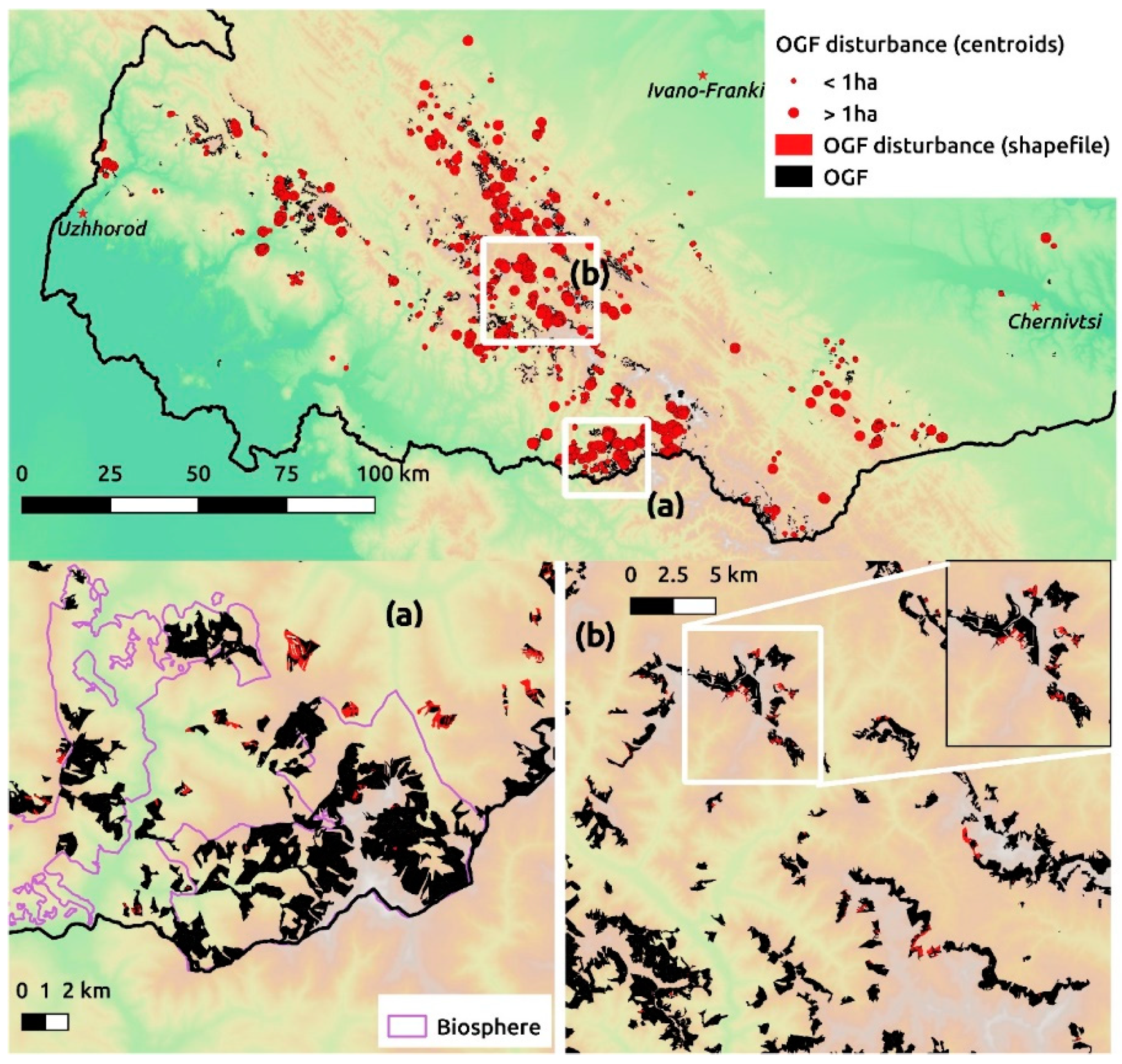
3.2. OGF Disturbance Mapping

Figure 6 shows the location of OGF we identified as disturbed between 2010 and 2019. Over this period, a total of 1334.9 ha of OGF was disturbed, equivalent to 1.8% of the area of OGF identified by the WWF. Average size of disturbance was 0.8 ha, with a median size of 0.1 ha. The difference in these values reflected a large number of clustered small-scale disturbance events, sometimes as small as a single pixel, which we suggest was due to selective logging. Damage was widespread across the region, although there were clusters of damage, with particularly severe disturbance in the North-West Maramures.
Figure 7 shows the annual rate of OGF disturbance for 2015, 2016, 2017, 2018 and 2019 across the Ukrainian Carpathians. The figure shows the disturbance rate for all the OGF that had been surveyed by the year we calculate disturbance. There is regional variability in the rate of disturbance, which varies from no loss to greater than 2% year−1.
Figure 8 shows annual rates of OGF disturbance across the entire region. The average annual disturbance rate from 2015 to 2019 is 0.34% year−1, with disturbance rates relatively constant over the first four years, whilst declining by about half in 2019. However, these rates are not directly comparable since the area surveyed for OGF has changed over this period. The OGF surveyed in 2016 and 2017 may have been in areas more or less prone to forest disturbance than in earlier survey years. Therefore, to allow an unbiased estimation of the variation in disturbance rates, we also calculated the rate for only the OGF surveyed in 2015 or earlier. Average rate of disturbance was 0.41% year−1 from 2015 to 2019. These disturbance rates are significantly higher than the 0.13% year-1 disturbance rate estimated for OGF in the Romanian Carpathians from 2000−2010 [41]. A remote sensing study of all forest in the Ukrainian Carpathians [19] found annual disturbance rates of about 0.5% year−1 from 2000–2007.
In May 2017, Ukraine passed a law protecting all OGF from logging. This was followed in January 2018 by a moratorium on the issuing of felling tickets for OGF areas. Prior to the introduction of this law, OGF enjoyed no specific protection beyond what was provided by their location within a Protected Area or forest management regime. Post May 2017, all OGF is strictly protected, regardless of location or management regime. We note that the date of the S-2 images used to compute disturbance for 2017 are all after May 2017. Therefore, all the disturbance calculated using the 2018 S-2 images will have occurred after the law’s passage. In the first year of the ban, the disturbance rates for all OGF polygons was essentially unchanged (0.37% year−1 in 2017 and 0.39% year−1 in 2018). In 2019, the OGF disturbance rate decreased to 0.19% year−1. This is about half the disturbance rate recorded for any previous year during 2015–2018, suggesting that the law has started to result in reduced disturbance rates.
The Carpathian Convention committed its signatories (Ukraine, Romania, Poland, Serbia, Slovakia, Hungary and the Czech Republic) to the protection of their virgin forest. The three first-named counties have significant areas (>10,000 ha) of OGF. In neighbouring Romania, an amendment to the Forest Law in 2008 (similar to the 2017 Ukraine law) protected OGF areas from logging, but only more recently have effective criteria [63,64,65] as to what forest qualifies as OGF been developed. Anecdotally [66], there seems to be a lack of effectiveness so far due to limited progress in OGF designation, and it would be interesting to see how the situation in Romania contrasts with our results in Ukraine.
Figure 9 shows the distribution of OGF disturbance rate by tree species, elevation, slope and distance to settlement. Norway spruce experienced faster rates of disturbance (0.66% year−1), than beech (0.16% year−1) and mountain pine (0.004% year−1). Disturbance was fairly consistent (0.4% year−1) for elevations between 300 and 900 m, with much slower rates above 1500 m (0.01% year−1). There is little OGF below 300 m (Figure 2a), and the high disturbance rate at these elevations was due to a few isolated disturbance events. Rates of disturbance were fastest for intermediate slopes of 10–15° (0.73% year−1) and slowest for slopes <5° (0.13% year−1). Steeper slopes of between 20° and 30° experienced slightly slower rates of disturbance than intermediate slopes, whilst the steepest slopes (>30°) experienced faster rates. In 2000, a 10 year moratorium [67] on clearfelling on steep slopes (>20°) was introduced. However, this ban lapsed in 2011, although there are currently attempts to reintroduce it [68]. Distance to the nearest settlement had little impact on disturbance rate although there was a slightly slower rate for OGF areas that were closest (<500 m) and furthest (>4000 m) from the nearest settlement. Both the study of OGF disturbance in the Romanian Carpathians [41] and the study of all forest in the Ukrainian Carpathians [19] found similar relationships between disturbance, slope and elevation.

3.3. Disturbance by Protection Category

Figure 10 compares the mean annual rate of OGF disturbance during 2015 to 2019 across different protection categories. The average OGF disturbance rate in PAs (Categories 1–11) was 0.06% year−1, substantially less than a mean of 0.45% year−1 in non-PAs (all other categories.) Outside of PAs, the OGF disturbance rate was faster in operational forests (1.1% year−1), compared to protection (0.29% year−1) and recreation (0.37% year−1) forest. Operational forests are designated for timber production, likely explaining the faster disturbance rates in this forest type.
Worldwide, PAs are generally located in remote areas of high and steep terrain compared to non-protected areas, contributing to the lower forest loss rates often reported in PAs [69]. In Ukrainian Carpathians, this locational bias is less obvious (Figure S1). For example, OGF in PAs occurred at lower elevation, less steep slopes and closer to villages (mean elevation of 1143 m, mean slope of 22° and mean distance from settlement of 2251 m) compared to protection forest (mean elevation of 1261 m, mean slope of 23.1°, mean distance of 2419 m). This demonstrates that the slower disturbance rates in PAs (0.06% in PAs compared to 0.29% in protection forest) is not due to location bias to higher ground, steeper slopes or more remote sites. We therefore conclude that PAs are effective in protecting OGF from disturbance. This finding is in agreement with a study [20] of all forest in the Ukrainian Carpathians from 1985 to 2010, which found disturbance rates significantly lower inside PAs, and that effectiveness steadily increased over the study period. A previous assessment of forest disturbance in the western Carpathians of Ukraine from 1978 to 2000 found that PAs had no impact on disturbance rates, suggesting that PA management in Ukraine has improved over recent decades. The recent declaration [70] to change boundaries of natural reserves, biosphere and national parks “with a view to include areas” of OGF should therefore help reduce loss of OGF.
In contrast to tropical areas, there has been comparatively little published work on forest loss and Protected Area effectiveness in Central and Eastern Europe. A study of OGF disturbance rates in the Romanian Carpathians from 2000 to 2010 [41] found, contrary to our results, little difference between disturbances in protected and unprotected OGF, with only National Parks found to be effective in reducing loss. Likewise, a paper [62] looking at the Caucasian Mountains (Russia and Georgia) from 1985 to 2010 found PAs to be ineffective, though forest loss was very low both in and out of PAs. Other studies have seen mixed results, with a study [71] of all forest in Central European Russia (1985–2010) finding strictly protected areas (IUCN I) to be effective, and multiple use PAs (National Parks and zakazniks) ineffective in preventing forest disturbance. A paper looking across the whole Carpathian region from 1985 to 2010 [20] found reserve effectiveness to vary strongly both with time and between the 6 studied countries.
The overall disturbance rates inside National Parks and Biosphere Reserves, and within Protected tracts, zakazniks and Nature Monuments, were roughly similar at 0.06–0.07% year−1. However, there were significant differences within the zoned areas. Within National Parks, areas designated as Economic Zones (0.21% year−1) had faster rates of disturbance compared to Recreation (0.06% year−1) and Protected Zones (0.04% year−1). In Biosphere Reserves, there was a similar disturbance rate in the protected area (0.1% year−1) compared to the buffer zone (0.07% year−1), both having faster rates than to the anthropogenic zone (0.02% year−1). However, the high rate for the biosphere protected zone reflected large disturbances in the North-east of the Marmaros Biosphere Reserve in 2018 (see inset Figure 6a), with disturbances in previous years and 2019 much lower. The recent declaration [70] that areas of OGF within biosphere reserves and National parks should be included within their protected zones should therefore help in protecting OGF. Disturbance rates were slowest in Natural Reserves (0.01% year−1).

4. Conclusions

Old-growth forests (OGFs) are rare and highly threatened forest in Europe. An ongoing field survey identified 73,591 ha of OGF in the Ukrainian Carpathians. We used multitemporal satellite imagery and Random Forest classification to detect disturbance in these OGF areas. Over the period 2010–2019, we identified a total of 1335 ha of disturbance in OGF areas, equivalent to 1.8% of total OGF area. We analysed a subset of OGF disturbance events and found that the majority of disturbances were manmade, likely due to forest harvesting. This confirms previous work suggesting that large-scale natural disturbance events are rare in the region.
Sentinel-2 satellite imagery was used to calculate annual disturbance rates for the years 2015–2019. For 2015 to 2018, disturbance rates were fairly constant at about 0.4% per year. In May 2017, Ukraine passed a new law banning logging in OGF areas. We found that while the disturbance rate in 2018 was not significantly different to that from 2015 to 2017, disturbance rates fell by half in 2019, suggesting that the logging ban may have reduced OGF disturbance. We compared the rate of disturbance in OGF under different forest management regimes. Protected areas, which cover about one third of OGF in the Ukraine Carpathians, were found to be effective in reducing disturbance, with annual disturbance rates 7–8 times lower than in OGF outside protected areas.
Our study suggests expansion of the protected area system would help reduce loss of OGF in Ukraine. Outside of protected areas, better enforcement of logging restrictions and the establishment of adequate liability for violation of protection requirements are important to the long-term survival of OGF. Our study gives a first indication that the ban on logging in OGF areas may be effective in reducing loss of OGF in Ukraine. Ongoing remote sensing analysis will play an important role in monitoring the success of the logging ban and of OGF conservation, not only in the Ukrainian Carpathians, but throughout Eastern Europe.

Supplementary Materials

The following are available online at https://www.mdpi.com/1999-4907/11/2/151/s1, Figure S1. Boxplots of old-growth forest grouped by protection category as a function of (a) elevation, (b) slope and (c) distance to nearest settlement. Median: line, box: first to third quartiles, whiskers: third quartile + 1.5×Interquartile Range (IQR) and first quartile-1.5×IQR. Abbreviations: N.P. is National Park, R.L.P. is Regional Landscape Park, Anthro. is Anthropogenic.

Author Contributions

Conceptualization, B.D.S. and D.V.S.; methodology, B.D.S..; software, B.D.S.; validation, B.D.S..; formal analysis, B.D.S..; investigation, B.D.S..; resources, B.D.S. and D.V.S.; data curation, B.D.S.; writing—original draft preparation, B.D.S..; writing—review and editing, D.V.S.; visualization, B.D.S..; supervision, D.V.S.; project administration, D.V.S.; funding acquisition, D.V.S. All authors have read and agreed to the published version of the manuscript.

Funding

We thank the United Bank of Carbon and the Natural Environment Research Council (NE/L013347/1) for funding. DVS acknowledges a Philip Leverhulme Prize.

Acknowledgments

We wish to thank WWF Ukraine and in particular Valeriia Nemykina, Taras Yamelynets and Roman Volosyanchuk for their assistance and provision of data.

Conflicts of Interest

The authors declare no conflict of interest. The funders had no role in the design of the study; in the collection, analyses, or interpretation of data; in the writing of the manuscript, or in the decision to publish the results.

References

  1. Keeton, W.S.; Chernyavskyy, M.; Grätzer, G.; Main-Knorn, M.; Shpylchak, M.; Bihun, Y. Structural characteristics and aboveground biomass of old-growth spruce–fir stands in the eastern Carpathian mountains, Ukraine. Plant Biosyst. Int. J. Deal. all Asp. Plant Boil. 2010, 144, 148–159. [Google Scholar] [CrossRef]
  2. Berg, A.; Ehnström, B.; Hallingbäck, T.; Gustafsson, L.; Jonsell, M.; Weslien, J. Threatened Plant, Animal, and Fungus Species in Swedish Forests: Distribution and Habitat Associations. Conserv. Boil. 1994, 8, 718–731. [Google Scholar] [CrossRef]
  3. Paillet, Y.; Bergès, L.; Hjältén, J.; Ódor, P.; Avon, C.; Bernhardt-Römermann, M.; Bijlsma, R.-J.; De Bruyn, L.; Fuhr, M.; Grandin, U.; et al. Biodiversity Differences between Managed and Unmanaged Forests: Meta-Analysis of Species Richness in Europe. Conserv. Boil. 2010, 24, 101–112. [Google Scholar] [CrossRef]
  4. Eckelt, A.; Müller, J.; Bense, U.; Brustel, H.; Bu\s sler, H.; Chittaro, Y.; Cizek, L.; Frei, A.; Holzer, E.; Kadej, M. “Primeval forest relict beetles” of Central Europe: a set of 168 umbrella species for the protection of primeval forest remnants. J. Insect Conserv. 2018, 22, 15–28. [Google Scholar] [CrossRef]
  5. Jacob, M.; Bade, C.; Calvete, H.; Dittrich, S.; Leuschner, C.; Hauck, M. Significance of over-mature and decaying trees for carbon stocks in a Central European natural spruce forest. Ecosystems. 2013, 16, 336–346. [Google Scholar] [CrossRef] [Green Version]
  6. Seedre, M.; Kopáček, J.; Janda, P.; Bace, R.; Svoboda, M. Carbon pools in a montane old-growth Norway spruce ecosystem in Bohemian Forest: Effects of stand age and elevation. For. Ecol. Manag. 2015, 346, 106–113. [Google Scholar] [CrossRef]
  7. Granata, M.; Gratani, L.; Bracco, F.; Sartori, F.; Catoni, R. Carbon stock estimation in an unmanaged old-growth forest: A case study from a broad-leaf deciduous forest in the Northwest of Italy. Int. For. Rev. 2016, 18, 444–451. [Google Scholar] [CrossRef]
  8. Sabatini, F.M.; Burrascano, S.; Keeton, W.S.; Levers, C.; Lindner, M.; Pötzschner, F.; Verkerk, P.J.; Bauhus, J.; Buchwald, E.; Chaskovsky, O.; et al. Where are Europe’s last primary forests? Divers. Distrib. 2018, 24, 1426–1439. [Google Scholar] [CrossRef] [Green Version]
  9. Text of the Convention—carpathianconvention.org. Available online: http://www.carpathianconvention.org/text-of-the-convention.html (accessed on 13 June 2017).
  10. Forest Code of Ukraine (in Ukrainian). Available online: https://zakon.rada.gov.ua/go/3852-12 (accessed on 10 June 2019).
  11. Moratorium on logging in Carpathian old-growth forests of Ukraine | WWF. Available online: http://wwf.panda.org/wwf_news/?321210/Moratorium-on-logging-in-Carpathian-old-growth-forests-of-Ukraine (accessed on 17 February 2019).
  12. Timber Market Regulation—Green Book (in Ukrainian). 2017. Available online: https://regulation.blob.core.windows.net/reg-blob/Green%20Book%20-%20Wood.pdf (accessed on 10 December 2019).
  13. Earthsight, Complicit in Corruption. Available online: https://docs.wixstatic.com/ugd/624187_673e3aa69ed84129bdfeb91b6aa9ec17.pdf (accessed on 10 December 2019).
  14. Selective Field Assessment of sanitary Logging Sites in Ukrainian Carpathians; WWF Germany. Available online: https://www.wwf.de/fileadmin/fm-wwf/Publikationen_PDF/WWF_Report-Sanitary-logging-Ukraine.pdf (accessed on 10 December 2019).
  15. V.E. Boreyko Mass violations of the law in the organization of sanitary cuttings in the NRF (in Ukrainian). Available online: http://ecoethics.ru/massovyie-narusheniya-zakona-pri-organizatsii-sanitarnyih-rubok-v-obektah-pzf/ (accessed on 10 December 2019).
  16. The volumes of illegal logging remain the same as for Yanukovych (in Ukrainian). Available online: https://racurs.ua/ua/792-nezakonna-vyrubka-lisu-jak-za-yanukovycha.html (accessed on 17 February 2019).
  17. FSC Ukraine National Risk Assessment FSC_NRA_UA V1-1. Available online: https://ic.fsc.org/en/document-center/id/244 (accessed on 17 February 2019).
  18. In the Ukrainian Carpathians abusive sanitary felling (in Ukrainian). Available online: https://zik.ua/news/2018/07/09/v_ukrainskyh_karpatah_zlovzhyvayut_sanitarnymy_rubkamy_1362225 (accessed on 17 Februray 2019).
  19. Kuemmerle, T.; Chaskovskyy, O.; Knorn, J.; Radeloff, V.C.; Kruhlov, I.; Keeton, W.S.; Hostert, P. Forest cover change and illegal logging in the Ukrainian Carpathians in the transition period from 1988 to 2007. Remote. Sens. Environ. 2009, 113, 1194–1207. [Google Scholar] [CrossRef]
  20. Butsic, V.; Munteanu, C.; Griffiths, P.; Knorn, J.; Radeloff, V.C.; Lieskovský, J.; Mueller, D.; Kuemmerle, T. The effect of protected areas on forest disturbance in the Carpathian Mountains 1985-2010. Conserv. Boil. 2017, 31, 570–580. [Google Scholar] [CrossRef]
  21. Kuemmerle, T.; Hostert, P.; Radeloff, V.C.; Perzanowski, K.; Kruhlov, I. Post-socialist forest disturbance in the Carpathian border region of Poland, Slovakia, and Ukraine. Ecol. Appl. 2007, 17, 1279–1295. [Google Scholar] [CrossRef] [PubMed]
  22. Griffiths, P.; Kuemmerle, T.; Baumann, M.; Radeloff, V.C.; Abrudan, I.V.; Lieskovský, J.; Munteanu, C.; Ostapowicz, K.; Hostert, P. Forest disturbances, forest recovery, and changes in forest types across the Carpathian ecoregion from 1985 to 2010 based on Landsat image composites. Remote. Sens. Environ. 2014, 151, 72–88. [Google Scholar] [CrossRef]
  23. Potapov, P.V.; Turubanova, S.A.; Tyukavina, A.; Krylov, A.M.; McCarty, J.L.; Radeloff, V.C.; Hansen, M.C. Eastern Europe’s forest cover dynamics from 1985 to 2012 quantified from the full Landsat archive. Remote Sens. Environ. 2015, 159, 28–43. [Google Scholar] [CrossRef]
  24. Vondrák, J.; Malíček, J.; Palice, Z.; Bouda, F.; Berger, F.; Sanderson, N.; Acton, A.; Pouska, V.; Kish, R. Exploiting hot-spots; effective determination of lichen diversity in a Carpathian virgin forest. PLoS ONE 2018, 13, e0203540. [Google Scholar] [CrossRef]
  25. Dymytrova, L.; Nadyeina, O.; Naumovych, A.; Keller, C.; Scheidegger, C. Primeval Beech Forests of Ukrainian Carpathians are Sanctuaries for Rare and Endangered Epiphytic Lichens. Herzogia. 2013, 26, 73–89. [Google Scholar] [CrossRef]
  26. Novikoff, A.; Hurdu, B.-I. A critical list of endemic vascular plants in the Ukrainian Carpathians. Contributii Botanice 2015, 50, 49–91. [Google Scholar]
  27. Zingstra, H.L.; Seffer, J.; Lasak, R.; Baltzer, M.; Bouwma, I.M.; Walters, L.J.; Smith, B.; Kitnaes, K.; Predoiu, G.E.; Prots, B. Towards an ecological network for the Carpathians; Wageningen UR Centre for Development Innovation: Wageningen, The Netherlands, 2009. [Google Scholar]
  28. Salvatori, V.; Okarma, H.; Ionescu, O.; Dovhanych, Y.; Find’O, S.; Boitani, L. Hunting legislation in the Carpathian Mountains: implications for the conservation and management of large carnivores. Wildl. Boil. 2002, 8, 3–10. [Google Scholar] [CrossRef]
  29. Group of Experts on the conservation of Large Carnivores In Europe; Council of Europe: Saanen, Gstaad, Switzerland, 2012; Available online: https://rm.coe.int/1680746445 (accessed on 10 December 2019).
  30. Kuemmerle, T.; Perzanowski, K.; Chaskovskyy, O.; Ostapowicz, K.; Halada, L.; Bashta, A.-T.; Kruhlov, I.; Hostert, P.; Waller, D.M.; Radeloff, V.C. European Bison habitat in the Carpathian Mountains. Boil. Conserv. 2010, 143, 908–916. [Google Scholar] [CrossRef]
  31. Volosyanchuk, R.; Prots, B.; Kagalo, A.; Shparyk, Y.; Cherniavskyi, M.; Bondaruk, G. Criteria and Methology for Virgin and Old-Growth (Quasi-Virgin) Forest Identification (in Ukrainian). Available online: http://d2ouvy59p0dg6k.cloudfront.net/downloads/old_growth_forest_identification_methodology.pdf. (accessed on 10 December 2019).
  32. Roman Volosyanchuk Virgin and Old Growth Forests in Ukraine. Available online: http://www.carpathianconvention.org/tl_files/carpathiancon/Downloads/03%20Meetings%20and%20Events/Working%20Groups/Sustainable%20Forest%20Management/6th%20meeting/presentations/VF_for_CC_Sopron_WWF_UA.pdf (accessed on 10 January 2018).
  33. On approval of the procedure for the division of forests in the category and allocation of specially protected forest areas (in Ukrainian). Available online: https://zakon.rada.gov.ua/go/733-2007-%D0%BF (accessed on 3 March 2019).
  34. On Approval of Rules of Cutting of Main Use (in Ukrainian). Available online: https://zakon.rada.gov.ua/go/z0085-10 (accessed on 10 April 2019).
  35. On Nature Reserve Fund of Ukraine (in Ukrainian). Available online: https://zakon.rada.gov.ua/go/2456-12 (accessed on 10 January 2019).
  36. On Approval of the Rules of Cutting of Main Uses in the Carpathian Mountain Forests (in Ukrainian). Available online: https://zakon.rada.gov.ua/go/929-2008-%D0%BF (accessed on 10 March 2019).
  37. On approval of the Rules for improving the quality of forests (in Ukrainian). Available online: https://zakon.rada.gov.ua/go/724-2007-%D0%BF (accessed on 10 March 2019).
  38. On Approval of Sanitary Rules in Forests of Ukraine (in Ukrainian). Available online: https://zakon.rada.gov.ua/go/555-95-%D0%BF (accessed on 10 March 2019).
  39. On regulation of issues related to the special use of forest resources (in Ukrainian). Available online: https://zakon.rada.gov.ua/go/761-2007-%D0%BF (accessed on 10 April 2019).
  40. ENPI FLEG Analysis of the division of forests by their functional designation (in Ukrainian). Available online: http://www.enpi-fleg.org/site/assets/files/2120/report_storozhuk_analysis_functional_division_of_forests.pdf (accessed on 10 December 2019).
  41. Knorn, J.A.N.; Kuemmerle, T.; Radeloff, V.C.; Keeton, W.S.; Gancz, V.; BIRIŞ, I.-A.; Svoboda, M.; Griffiths, P.; Hagatis, A.; Hostert, P. Continued loss of temperate old-growth forests in the Romanian Carpathians despite an increasing protected area network. Environ. Conserv. 2013, 40, 182–193. [Google Scholar] [CrossRef] [Green Version]
  42. National Park “Verkhovyna” (in Ukrainian). Available online: http://nppver.at.ua/photo/fotografija_1/1-0-141 (accessed on 19 March 2019).
  43. Territorial Protection (in Ukrainian). Available online: http://cbr.nature.org.ua/prot_u.htm (accessed on 21 March 2019).
  44. Drusch, M.; Del Bello, U.; Carlier, S.; Colin, O.; Fernandez, V.; Gascon, F.; Hoersch, B.; Isola, C.; Laberinti, P.; Martimort, P. Sentinel-2: ESA’s optical high-resolution mission for GMES operational services. Remote Sensing of Environment 2012, 120, 25–36. [Google Scholar] [CrossRef]
  45. Louis, J.; Debaecker, V.; Pflug, B.; Main-Knorn, M.; Bieniarz, J.; Mueller-Wilm, U.; Cadau, E.; Gascon, F. Sentinel-2 Sen2Cor: L2A Processor for Users. In Proceedings of the Proceedings Living Planet Symposium 2016, Prague, Czech Republic, 9–13 May 2016; pp. 1–8, Spacebooks Online. [Google Scholar]
  46. Breiman, L. Random forests. Mach. Learn. 2001, 45, 5–32. [Google Scholar] [CrossRef] [Green Version]
  47. Shchur, A.; Bragina, E.; Sieber, A.; Pidgeon, A.M.; Radeloff, V.C. Monitoring selective logging with Landsat satellite imagery reveals that protected forests in Western Siberia experience greater harvest than non-protected forests. Environ. Conserv. 2017, 44, 191–199. [Google Scholar] [CrossRef] [Green Version]
  48. Hermosilla, T.; Wulder, M.A.; White, J.C.; Coops, N.C.; Hobart, G.W. Regional detection, characterization, and attribution of annual forest change from 1984 to 2012 using Landsat-derived time-series metrics. Remote. Sens. Environ. 2015, 170, 121–132. [Google Scholar] [CrossRef]
  49. Senf, C.; Pflugmacher, D.; Hostert, P.; Seidl, R. Using Landsat time series for characterizing forest disturbance dynamics in the coupled human and natural systems of Central Europe. ISPRS J. Photogramm. Remote. Sens. 2017, 130, 453–463. [Google Scholar] [CrossRef]
  50. Einzmann, K.; Immitzer, M.; Böck, S.; Bauer, O.; Schmitt, A.; Atzberger, C. Windthrow Detection in European Forests with Very High-Resolution Optical Data. Forests 2017, 8, 21. [Google Scholar] [CrossRef] [Green Version]
  51. Rodriguez-Galiano, V.F.; Ghimire, B.; Rogan, J.; Olmo, M.C.; Rigol-Sanchez, J.P. An assessment of the effectiveness of a random forest classifier for land-cover classification. ISPRS J. Photogramm. Remote. Sens. 2012, 67, 93–104. [Google Scholar] [CrossRef]
  52. Waske, B.; Van Der Linden, S.; Benediktsson, J.A.; Rabe, A.; Hostert, P. Sensitivity of Support Vector Machines to Random Feature Selection in Classification of Hyperspectral Data. IEEE Trans. Geosci. Remote. Sens. 2010, 48, 2880–2889. [Google Scholar] [CrossRef] [Green Version]
  53. Pedregosa, F.; Varoquaux, G.; Gramfort, A.; Michel, V.; Thirion, B.; Grisel, O.; Blondel, M.; Prettenhofer, P.; Weiss, R.; Dubourg, V. Scikit-learn: Machine learning in Python. J. Mach. Learn. res. 2011, 12, 2825–2830. [Google Scholar]
  54. Jarvis, A.; Reuter, H.I.; Nelson, A.; Guevara, E. Hole-filled SRTM for the globe Version 4. Available online: https://research.utwente.nl/en/publications/hole-filled-srtm-for-the-globe-version-4-data-grid. (accessed on 10 December 2019).
  55. Haklay, M.; Weber, P. Openstreetmap: User-generated street maps. IEEE Pervas. Comput. 2008, 7, 12–18. [Google Scholar] [CrossRef] [Green Version]
  56. Trotsiuk, V.; Hobi, M.L.; Commarmot, B. Age structure and disturbance dynamics of the relic virgin beech forest Uholka (Ukrainian Carpathians). For. Ecol. Manag. 2012, 265, 181–190. [Google Scholar] [CrossRef]
  57. Trotsiuk, V.; Svoboda, M.; Janda, P.; Mikolas, M.; Bace, R.; Rejzek, J.; Šamonil, P.; Chaskovskyy, O.; Korol, M.; Myklush, S. A mixed severity disturbance regime in the primary Picea abies (L.) Karst. forests of the Ukrainian Carpathians. For. Ecol. Manag. 2014, 334, 144–153. [Google Scholar] [CrossRef]
  58. Hobi, M.L.; Commarmot, B.; Bugmann, H. Pattern and process in the largest primeval beech forest of E urope (U krainian C arpathians). J. Veget. Sci. 2015, 26, 323–336. [Google Scholar] [CrossRef]
  59. Cohen, W.B.; Maiersperger, T.K.; Spies, T.A.; Oetter, D.R. Modelling forest cover attributes as continuous variables in a regional context with Thematic Mapper data. Inter. J. Remote Sensi. 2001, 22, 2279–2310. [Google Scholar] [CrossRef]
  60. Healey, S.; Cohen, W.; Zhiqiang, Y.; Krankina, O. Comparison of Tasseled Cap-based Landsat data structures for use in forest disturbance detection. Remote. Sens. Environ. 2005, 97, 301–310. [Google Scholar] [CrossRef]
  61. Ozdogan, M. A Practical and Automated Approach to Large Area Forest Disturbance Mapping with Remote Sensing. PLoS ONE 2014, 9, e78438. [Google Scholar] [CrossRef]
  62. Bragina, E.; Radeloff, V.; Baumann, M.; Wendland, K.; Kuemmerle, T.; Pidgeon, A. Effectiveness of protected areas in the Western Caucasus before and after the transition to post-socialism. Boil. Conserv. 2015, 184, 456–464. [Google Scholar] [CrossRef]
  63. Order, no. 3397/2012 establishing the criteria and indicators for the identification of virgin and quasi-virgin forests in Romania (in Romanian). Available online: https://lege5.ro/Gratuit/gmzdsmrwgi/ordinul-nr-3397-2012-privind-stabilirea-criteriilor-si-indicatorilor-de-identificare-a-padurilor-virgine-si-cvasivirgine-in-romania (accessed on 15 January 2017).
  64. Order, no. 1417/2016 regarding the establishment of the National catalog of virgin and quasi-virgin forests in Romania (in Romanian). Available online: https://lege5.ro/Gratuit/gezdinjqge3q/ordinul-nr-1417-2016-privind-constituirea-catalogului-national-al-padurilor-virgine-si-cvasivirgine-din-romania (accessed on November 2017).
  65. Order, no. 2525/2016 regarding the establishment of the National Catalog of virgin and quasi-virgin forests in Romania (in Romanian). Available online: https://lege5.ro/Gratuit/ge2dkojxgazq/ordinul-nr-2525-2016-privind-constituirea-national-al-padurilor-virgine-si-cvasivirgine-din-romania (accessed on 10 December 2019).
  66. Matthias Schickhofer; Ulrich Schwarz PRIMOFARO - Inventory of Potential Primary and Old-Growth Forest Areas in Romania. Available online: https://www.euronatur.org/fileadmin/docs/Urwald-Kampagne_Rumaenien/PRIMOFARO_24092019_layouted.pdf (accessed on 10 December 2019).
  67. On a moratorium on continuous felling on mountain slopes in fir-beech forests of the Carpathian region (in Ukrainian). Available online: https://zakon.rada.gov.ua/go/1436-14 (accessed on 25 February 2019).
  68. On amendments to some laws of Ukraine (regarding the introduction of a ban on the continuous cutting of fir-beech forests on the mountain slopes of the Carpathian region) (in Ukrainian). Available online: http://search.ligazakon.ua/l_doc2.nsf/link1/JH57H00A.html (accessed on 25 February 2019).
  69. Joppa, L.N.; Pfaff, A. High and Far: Biases in the Location of Protected Areas. PLoS ONE 2009, 4, 8273. [Google Scholar] [CrossRef]
  70. On Approval of the Methodology for Determining the Territory’s Membership to Monuments of Nature (in Ukrainian). Available online: https://zakon.rada.gov.ua/go/z0708-18 (accessed on 14 April 2019).
  71. Wendland, K.J.; Baumann, M.; Lewis, D.J.; Sieber, A.; Radeloff, V.C. Protected Area Effectiveness in European Russia: A Postmatching Panel Data Analysis. Land Econ. 2015, 91, 149–168. [Google Scholar] [CrossRef]
Figure 1. Map of study area showing old-growth forest (OGF) areas identified through surveys conducted by WWF. Elevation is shown as background colour and ranges from 100 m (light green) to 2060 m (orange). Solid colours show the dominant tree species within OGF. Inset map shows location of study area within Ukraine. Numbers identify important mountain peaks. Mixed OGF consists of two or more species with at least 20% abundance. “Other C” and “Other B” are non-mixed conifer and broadleaved OGFs respectively that are comprised of species other than beech, Norway spruce or mountain pine.
Forests 11 00151 g001
Figure 2. Proportional area of old-growth forest by (a) tree species, (b) elevation, (c) slope and (d) distance to settlement. Abbreviations as in Figure 1.
Forests 11 00151 g002
Figure 3. Fractional area of old-growth forest covered by various protection categories. For National park and Biosphere reserves zoned areas are shown. R.L.P. is Regional Landscape Park, PA is Protected Area.
Forests 11 00151 g003
Figure 4. Summer 2019 (1st July) Sentinel-2 RGB image of an area of disturbed Norway spruce-dominated OGF. The disturbance was classified as manmade due to sharply-defined disturbance boundaries and logging tracks. Red lines show boundaries of OGF shapefiles.
Forests 11 00151 g004
Figure 5. Confusion matrix for Random Forest classification of (a) Sentinel-2 and (b) Landsat images showing pixel numbers and, in Sum row and column, classification accuracies. Numeric labels represent disturbance year (e.g., 15 = 2015.) Class label abbreviations are: Dist = disturbed OGF, Un = Undisturbed OGF.
Forests 11 00151 g005
Figure 6. Distribution of old-growth forest (OGF) and OGF disturbances over the period 2010 to 2019. Shaded area highlights (a) Northwest Maramures and (b) north Svydovets ridge, Bratkovsky ridge and Bushtul massif. Biosphere in (a) shows outline of UNESCO Biosphere reserves.
Forests 11 00151 g006
Figure 7. Distribution of Old-Growth Forest (OGF) annual disturbance for 2015–2019 calculated for raions (districts) and Iaremchans’ka Municipality (mis’ka rada).
Forests 11 00151 g007
Figure 8. Annual disturbance of old growth forest (OGF) in the Ukrainian Carpathians (red: rate of disturbance of all OGF surveyed by the year of disturbance, green: rate of disturbance of OGF surveyed in 2015 or earlier).
Forests 11 00151 g008
Figure 9. Mean annual disturbance from 2015–2019 of old-growth forest by (a) tree species, (b) elevation, (c) slope and (d) distance to settlement. Abbreviations as in Figure 1.
Forests 11 00151 g009
Figure 10. Mean annual rate of old-growth forest disturbance by protection category for 2015-2019. R.L.P. is Regional Landscape Park., PA is Protected Area. Rates for Biosphere reserves and National Parks calculated across all zones. For Protected Tract the mean rate is calculated for 2016-2019 and for R.L.P. for 2017-2019 as no OGF had been surveyed in these categories in earlier years.
Forests 11 00151 g010
Table 1. Categories of forest protection in Ukraine.
Protected AreasIUCN CategoryCategory No.
Natural ReserveIa1
UNESCO-MAB Biosphere Reserve Zone of Anthropogenic Landscapes (2),
Buffer Zone (3),
Protected Zone (4),
National Natural ParkIIEconomic zone (5),
Protected zone (6),
Recreation zone (7),
Regional Landscape parkVEconomic zone (8),
Protected zone (8),
Recreation zone (8),
ZakaznikIV9
Nature MonumentIII10
Protected tractIb11
Forests of scientific purpose 12
Recreation forest
Recreation * 13
Protection forest
Anti-erosion 14
Other protective 15
Operational forest 16
* Recreation—Comprising Sanitary forest (“Sanitary protection of health-improving territories”), Green Zone and Recreational forest; Other protective—Comprising Roadside forest (Forests along roads and railways), Waterbank forest (Forests along the banks of rivers, lakes, reservoirs etc.).
Table 2. Comparison of the Sentinel-2 (S-2) and Landsat bands used in the study. NIR is Near Infra-Red, SWIR is Short Wave Infra-Red, OLI is Operational Land Imager, TM is Thematic Mapper and ETM+ is Enhanced Thematic Mapper Plus. All Landsat bands are 30 m resolution. For S-2 bands B2, B3, B4 and B8 are 10 m resolution while the others are 20 m. For S-2, wavelength ranges given are for satellite S-2A, the values for S-2B vary slightly.
Sentinel-2Wavelength
Range(nm)
Landsat 5 / Landsat 7
(TM/ETM+)
Wavelength
Range(nm)
Landsat 8
(OLI)
Wavelength
Range(nm)
B2(Blue)448–546B1(Blue)450–520B2(Blue)452–512
B3(Green)538–583B2(Green)520–600B3(Green)533–590
B4(Red)646–684B3(Red)630–690B4(Red)636–673
B5(Red Edge)694–713
B6(Red Edge)731–749
B7(Red Edge)769–797
B8(NIR)763–908B4(NIR)770–900B (NIR)851–879
B8A(NIR)848–881
B11(SWIR)1542–1685B5(SWIR)1550–1750B6(SWIR)1566–1651
B12(SWIR)2081–2323B7(SWIR)2090–2350B7(SWIR)2107–2294

