A Statistical Approach to Detect Land Cover Changes in Mediterranean Ecosystems Using Multi-Temporal Landsat Data: The Case Study of Pianosa Island, Italy
Abstract
:1. Introduction
2. Materials and Methods
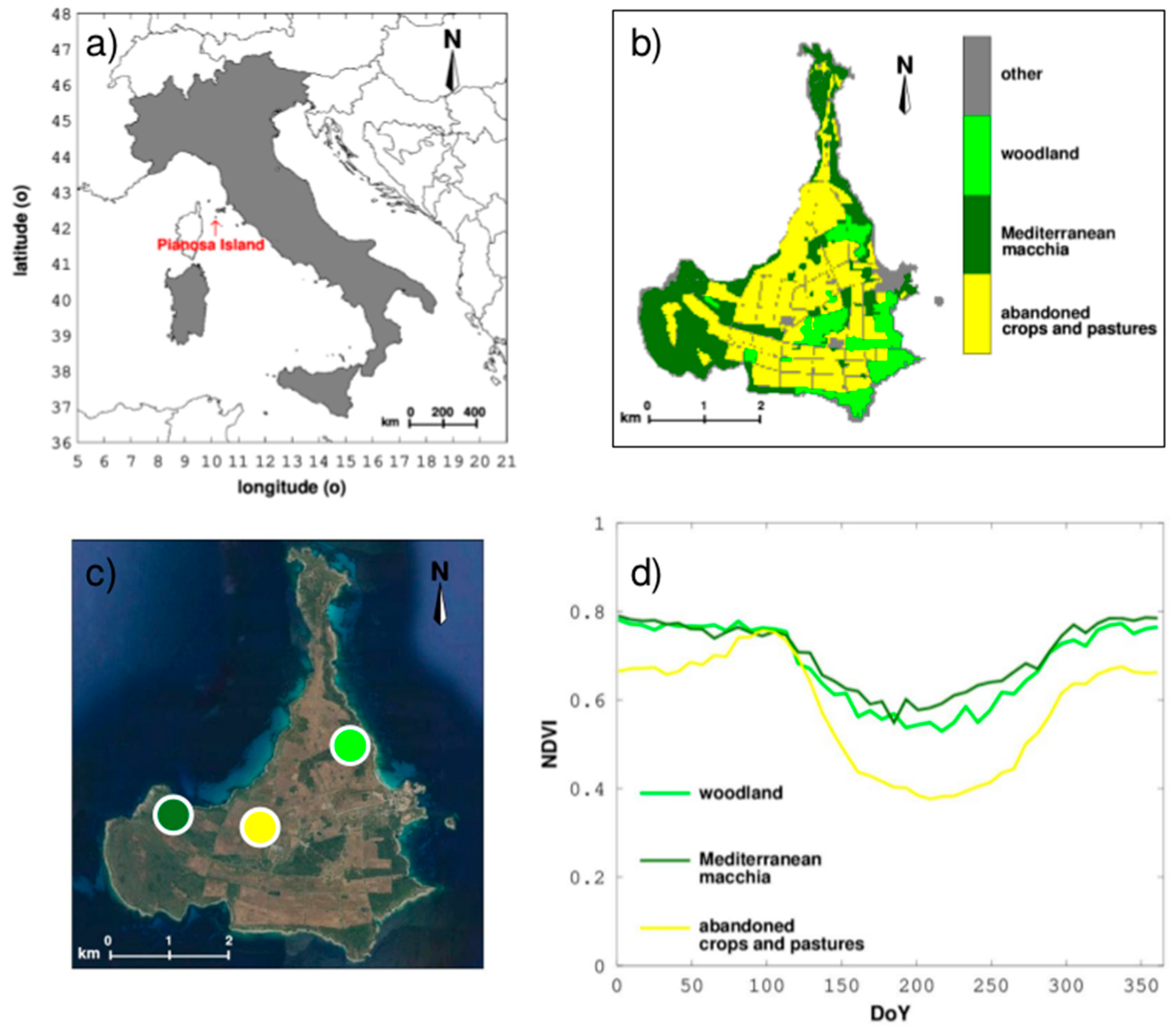
2.1. Study Area
2.2. Acquisition of Long-Term Multi-Temporal Image Data
2.3. Calculation of the Normalized Difference Vegetation Index (NDVI)
2.4. Image Pre-Processing
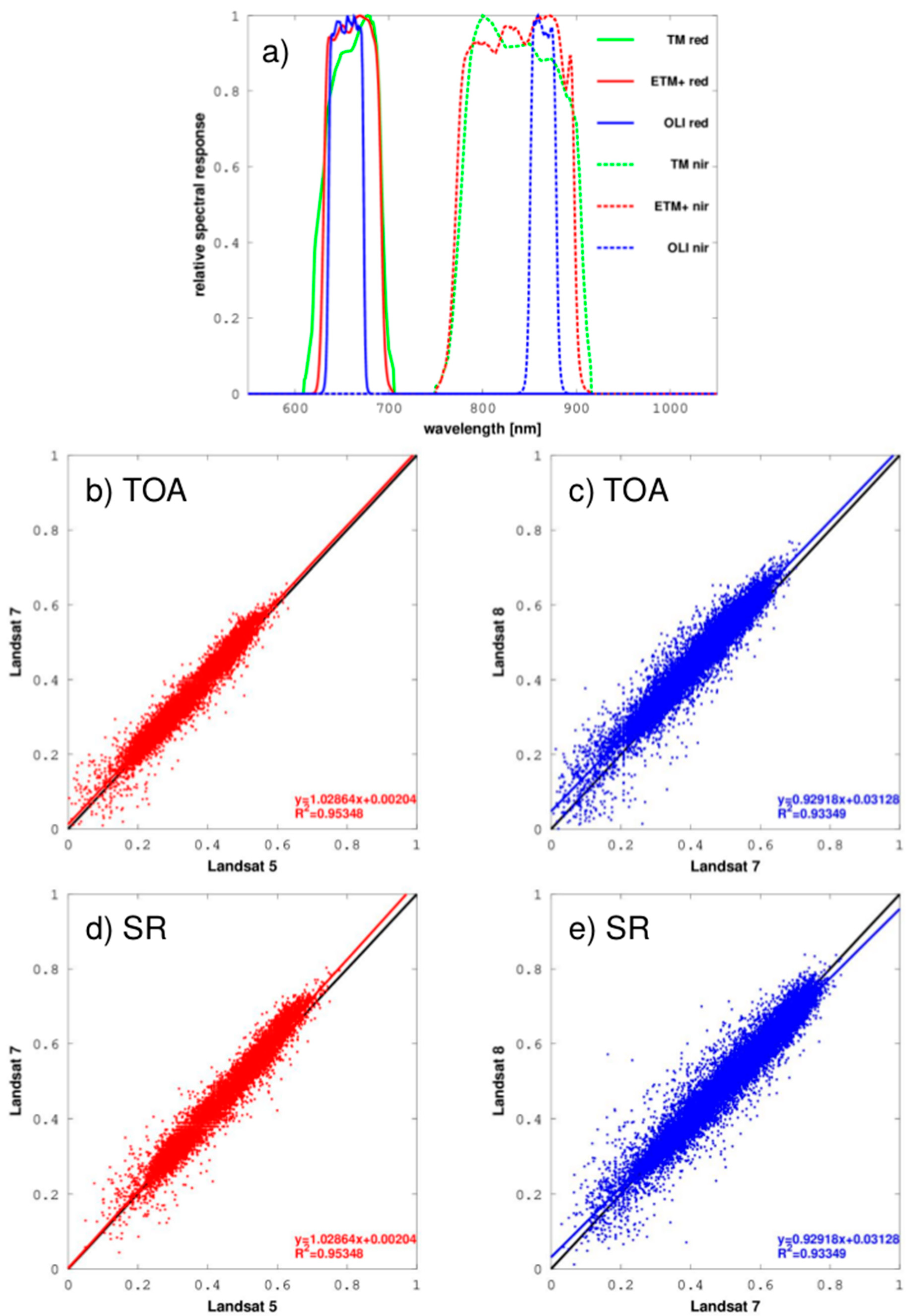
2.5. Landsat Data Continuity across Multi-Temporal NDVI Series
2.6. Seasonal Vegetation Change Detection
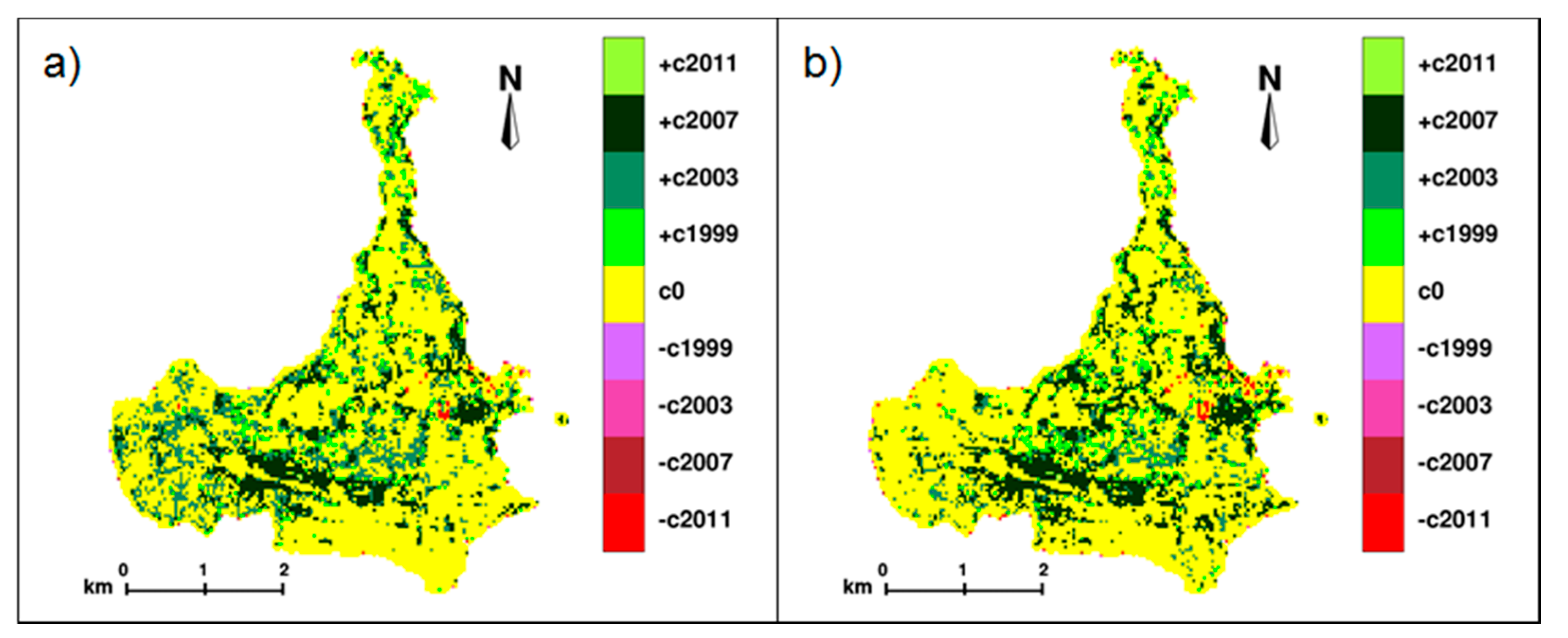
3. Results and Discussion
4. Conclusions
Supplementary Materials
Author Contributions
Funding
Conflicts of Interest
References
- Ozturk, T.; Ceber, Z.P.; Türkeş, M.; Kurnaz, M.L. Projections of climate change in the Mediterranean Basin by using downscaled global climate model outputs. Int. J. Climatol. 2015, 35, 4276–4292. [Google Scholar] [CrossRef]
- Marchese, C. Biodiversity hotspots: A shortcut for a more complicated concept. Glob. Ecol. Conserv. 2015, 3, 297–309. [Google Scholar] [CrossRef] [Green Version]
- Mancino, G.; Nolè, A.; Ripullone, F.; Ferrara, A. Landsat TM imagery and NDVI differencing to detect vegetation change: Assessing natural forest expansion in Basilicata, southern Italy. iForest 2014, 7, 75–84. [Google Scholar] [CrossRef] [Green Version]
- Piussi, P. Woodland Recolonisation and Postagricultural Development in Italy. In Mountain Ecosystems: Studies in Treeline Ecology; Broll, G., Keplin, B., Eds.; Springer: Berlin/Heidelberg, Germany, 2005; pp. 237–251. [Google Scholar] [CrossRef]
- Scartazza, A.; Vaccari, F.P.; Bertolini, T.; Di Tommasi, P.; Lauteri, M.; Miglietta, F.; Brugnoli, E. Comparing integrated stable isotope and eddy covariance estimates of water-use efficiency on a Mediterranean successional sequence. Oecologia 2014, 176, 581–594. [Google Scholar] [CrossRef] [PubMed]
- Lu, D.; Mausel, P.; Brondízio, E.; Moran, E. Change detection techniques. Int. J. Remote Sens. 2004, 25, 2365–2401. [Google Scholar] [CrossRef]
- Gross, J.E.; Goetz, S.J.; Cihlar, J. Application of remote sensing to parks and protected area monitoring: Introduction to the special issue. Remote Sens. Environ. 2009, 113, 1343–1345. [Google Scholar] [CrossRef]
- Wiens, J.; Sutter, R.; Anderson, M.; Blanchard, J.; Barnett, A.; Aguilar-Amuchastegui, N.; Avery, C.; Laine, S. Selecting and conserving lands for biodiversity: The role of remote sensing. Remote Sens. Environ. 2009, 113, 1370–1381. [Google Scholar] [CrossRef] [Green Version]
- Belward, A.S.; Skøien, J.O. Who launched what, when and why; trends in global land-cover observation capacity from civilian earth observation satellites. ISPRS J. Photogramm. 2015, 103, 115–128. [Google Scholar] [CrossRef]
- Gómez, C.; White, J.C.; Wulder, M.A. Optical remotely sensed time series data for land cover classification: A review. ISPRS J. Photogramm. 2016, 116, 55–72. [Google Scholar] [CrossRef] [Green Version]
- Xie, Y.; Sha, Z.; Yu, M. Remote sensing imagery in vegetation mapping: A. review. J. Plant Ecol. 2008, 1, 9–23. [Google Scholar] [CrossRef]
- Huete, A.; Liu, H.Q.; Batchily, K.; van Leeuwen, W. A comparison of vegetation indices global set of TM images for EOS-MODIS. Remote Sens. Environ. 1997, 59, 440–451. [Google Scholar] [CrossRef]
- Huete, A.; Didan, K.; Miura, T.; Rodriguez, E.P.; Gao, X.; Ferreira, L.G. Overview of the radiometric and biophysical performance of the MODIS vegetation indices. Remote Sens. Environ. 2002, 83, 195–213. [Google Scholar] [CrossRef]
- Hargrove, W.W.; Spruce, J.P.; Gasser, G.E.; Hoffman, F.M. Toward a national early warning system for forest disturbances using remotely sensed canopy phenology. Photogramm. Eng. Remote Sens. 2009, 75, 1150–1156. [Google Scholar]
- Lawley, V.; Lewis, M.; Clarke, K.; Ostendorf, B. Site-based and remote sensing methods for monitoring indicators of vegetation condition: An Australian review. Ecol. Indic. 2016, 60, 1273–1283. [Google Scholar] [CrossRef] [Green Version]
- Sannier, C.; McRoberts, R.E.; Fichet, L.V.; Makaga, E.M.K. Using the regression estimator with Landsat data to estimate proportion forest cover and net proportion deforestation in Gabon. Remote Sens. Environ. 2014, 151, 138–148. [Google Scholar] [CrossRef]
- Woodcock, C.E.; Allen, R.; Anderson, M.; Belward, A.; Bindschadler, R.; Cohen, W.B.; Gao, F.; Goward, S.N.; Helder, D.; Helmer, E.; et al. Free access to Landsat imagery. Science 2008, 320, 1011–1012. [Google Scholar] [CrossRef]
- Roy, D.P.; Qin, Y.; Kovalskyy, V.; Vermote, E.F.; Ju, J.; Egorov, A.; Hansen, M.C.; Kommareddy, I.; Yan, L. Conterminous United States demonstration and characterization of MODIS-based Landsat ETM + atmospheric correction. Remote Sens. Environ. 2014, 140, 433–449. [Google Scholar] [CrossRef] [Green Version]
- Galidaki, G.; Zianis, D.; Gitas, I.; Radoglou, K.; Karathanassi, V.; Tsakiri–Strati, M.; Woodhouse, I.; Mallinis, G. Vegetation biomass estimation with remote sensing: Focus on forest and other wooded land over the Mediterranean ecosystem. Int. J. Remote Sens. 2017, 38, 1940–1966. [Google Scholar] [CrossRef] [Green Version]
- Johnson, R.D.; Kasischke, E.S. Change vector analysis: A technique for the multispectral monitoring of land cover and condition. Int. J. Remote Sens. 1998, 19, 411–426. [Google Scholar] [CrossRef]
- Dai, X.L.; Khorram, S. Remotely sensed change detection based on artificial neural networks. Photogramm. Eng. Remote Sens. 1999, 65, 1187–1194. [Google Scholar]
- Metternicht, G. Change detection assessment using fuzzy sets and remotely sensed data: An application of topographic map revision. ISPRS J. Photogramm. 1999, 54, 221–233. [Google Scholar] [CrossRef]
- Bruzzone, L.; Prieto, D.F. Automatic analysis of the difference image for unsupervised change detection. IEEE Trans. Geosci. Remote 2000, 38, 1171–1182. [Google Scholar] [CrossRef] [Green Version]
- Chan, J.C.; Chan, K.; Yeh, A. Detecting the Nature of Change in an Urban Environment: A Comparison of Machine Learning Algorithms. Photogramm. Eng. Remote Sens. 2001, 67, 213–225. [Google Scholar]
- Im, J.; Jensen, J.R. A change detection model based on neighborhood correlation image analysis and decision tree classification. Remote Sens. Environ. 2005, 99, 326–340. [Google Scholar] [CrossRef]
- Hansen, M.C.; Loveland, T.R. A review of large area monitoring of land cover change using Landsat data. Remote Sens. Environ. 2012, 122, 66–74. [Google Scholar] [CrossRef]
- Ilsever, M.; Ünsalan, C. Two-Dimensional Change Detection Methods; Springer: London, UK, 2012. [Google Scholar] [CrossRef]
- Simoniello, T.; Coluzzi, R.; Imbrenda, V.; Lanfredi, M. Land cover changes and forest landscape evolution (1985–2009) in a typical Mediterranean agroforestry system (high Agri Valley). Nat. Hazards Earth Syst. 2015, 15, 1201–1214. [Google Scholar] [CrossRef] [Green Version]
- Imbrenda, V.; Coluzzi, R.; Lanfredi, M.; Loperte, A.; Satriani, A.; Simoniello, T. Analysis of landscape evolution in a vulnerable coastal area under natural and human pressure. Geomat. Nat. Haz. Risk. 2018, 9, 1249–1279. [Google Scholar] [CrossRef] [Green Version]
- Coppin, P.; Jonckheere, I.; Nackaerts, K.; Muys, B.; Lambin, E. Review ArticleDigital change detection methods in ecosystem monitoring: A review. Int. J. Remote Sens. 2004, 25, 1565–1596. [Google Scholar] [CrossRef]
- Vaccari, F.P.; Lugato, E.; Gioli, B.; D’Acqui, L.; Genesio, L.; Toscano, P.; Matese, A.; Miglietta, F. Land use change and soil organic carbon dynamics in Mediterranean agro-ecosystems: The case study of Pianosa Island. Geoderma 2012, 175–176, 29–36. [Google Scholar] [CrossRef]
- Baldini, R.M. The vascular flora of the Pianosa Island (Tuscan Archipelago): Taxonomic revision and updating. Webbia 2000, 55, 107–189. [Google Scholar] [CrossRef]
- Colom, M.R.; Vaccari, F.P.; Scartazza, A.; Brugnoli, E.; Zerbi, G.; Sforzi, S.; Baraldi, R.; Cotrufo, M.F.; D’Acqui, L.P.; Santi, C.; et al. Pianosa island: Structure, functioning and biodiversity of main ecosystems. J. Mediterr. Ecol. 2004, 5, 31–40. [Google Scholar]
- Global Agriculture Monitoring Project. Available online: http://pekko.geog.umd.edu/usda/test/ (accessed on 1 September 2016).
- U.S. Geological Survey, LSDS Science Research and Development (LSRD). Available online: https://espa.cr.usgs.gov/ (accessed on 1 September 2016).
- Chander, G.; Markham, B.L.; Helder, D.L. Summary of current radiometric calibration coefficients for Landsat MSS, TM, ETM +, and EO-1 ALI sensors. Remote Sens. Environ. 2009, 113, 893–903. [Google Scholar] [CrossRef]
- Roy, D.P.; Kovalskyy, V.; Zhang, H.K.; Vermote, E.F.; Yan, L.; Kumar, S.S.; Egorov, A. Characterization of Landsat-7 to Landsat-8 reflective wavelength and normalized difference vegetation index continuity. Remote Sens. Environ. 2016, 185, 57–70. [Google Scholar] [CrossRef] [Green Version]
- Singh, A. Review article: Digital change detection techniques using remotely-sensed data. Int. J. Remote Sens. 1989, 10, 989–1003. [Google Scholar] [CrossRef] [Green Version]
- U.S. Geological Survey, Earth Resources Observation and Science (EROS) Center Science Processing Architecture (ESPA) On-Demand Interface User Guide; U.S. Department of the Interior: Sioux Falls, SD, USA, 2019.
- Wulder, M.A.; Ortlepp, S.M.; White, J.C.; Maxwell, S. Evaluation of Landsat-7 SLC-off image products for forest change detection. Can. J. Remote Sens. 2008, 34, 93–99. [Google Scholar] [CrossRef]
- Royston, P. A remark on algorithm as 181: The w test for normality. Appl. Stat. J. Roy. St. C. 1995, 44, 547–551. [Google Scholar] [CrossRef]
- Hahn, G.J.; Shapiro, S.S. Statistical Models in Engineering; John Wiley & Sons, INC.: New York, NY, USA, 1994. [Google Scholar]
- Regione Toscana—SITA: Cartoteca. Available online: http://www502.regione.toscana.it/geoscopio/cartoteca.html (accessed on 1 September 2016).
- Maselli, F.; Vaccari, F.P.; Chiesi, M.; Romanelli, S.; D’Acqui, L.P. Modelling and analyzing the water and carbon dynamics of Mediterranean macchia by the use of ground and remote sensing data. Ecol. Model. 2017, 351, 1–13. [Google Scholar] [CrossRef]
- Repetti, E. Dizionario Geografico Fisico Storico Della Toscana; Repetti: Firenze, Italy, 1835; Volume 2, pp. 607–611. [Google Scholar]


| Date | Sensor | Path/Row | DoY | Sun Elevation [°] | Sun Azimuth [°] | Scene Identifier |
|---|---|---|---|---|---|---|
| 11/07/1999 | ETM+ | 193/030 | 192 | 61.94 | 131.48 | LE71930301999192EDC00 |
| 05/08/1999 | ETM+ | 192/030 | 217 | 54.69 | 140.38 | LE71920301999217EDC00 |
| 21/08/1999 | ETM+ | 192/031 | 233 | 60.68 | 131.08 | LE71920311999233NSG00 |
| 08/08/2003 | TM | 192/030 | 220 | 54.88 | 132.02 | LT51920302003220MTI01 |
| 17/07/2007 | ETM+ | 193/030 | 198 | 60.68 | 131.08 | LE71930302007198ASN00 |
| 02/08/2007 | ETM+ | 193/030 | 214 | 60.68 | 131.08 | LE71930302007214ASN00 |
| 12/09/2007 | ETM+ | 192/030 | 255 | 46.83 | 148.56 | LE71920302007255ASN00 |
| 19/07/2008 | ETM+ | 193/030 | 201 | 60.13 | 131.25 | LE71930302008201ASN00 |
| 04/08/2008 | ETM+ | 193/030 | 217 | 57.11 | 135.26 | LE71930302008217ASN00 |
| 13/08/2008 | ETM+ | 192/030 | 226 | 55.04 | 138.11 | LE71920302008226ASN00 |
| 29/08/2008 | ETM+ | 192/030 | 242 | 50.76 | 143.66 | LE71920302008242ASN00 |
| 30/09/2008 | ETM+ | 192/030 | 274 | 40.47 | 153.80 | LE71920302008274EDC00 |
| 30/07/2009 | TM | 193/030 | 211 | 58.28 | 133.95 | LT51930302009211MOR00 |
| 10/07/2010 | TM | 192/030 | 191 | 61.71 | 130.51 | LT51920302010191MOR00 |
| 14/08/2011 | TM | 192/030 | 226 | 55.03 | 138.30 | LT51920302011226MOR00 |
| 22/08/2011 | ETM+ | 192/030 | 234 | 53.52 | 142.77 | LE71920302011234ASN00 |
| 05/06/2015 | ETM+ | 193/030 | 156 | 64.08 | 136.78 | LE71930302015156NSG00 |
| 16/07/2015 | ETM+ | 192/030 | 197 | 64.08 | 136.78 | LE71920302015197NSG00 |
| 09/09/2015 | ETM+ | 192/031 | 252 | 48.78 | 151.27 | LE71930302015252NSG00 |
| 06/06/2015 | OLI | 192/030 | 157 | 64.11 | 136.48 | LC81920302015157LGN00 |
| 13/06/2015 | OLI | 193/030 | 164 | 64.42 | 135.19 | LC81930302015164LGN00 |
| 22/06/2015 | OLI | 192/031 | 173 | 65.12 | 131.18 | LC81920312015173LGN00 |
| 29/06/2015 | OLI | 193/030 | 180 | 64.01 | 133.72 | LC81930302015180LGN00 |
| 08/07/2015 | OLI | 192/030 | 189 | 63.20 | 134.02 | LC81920302015189LGN00 |
| 24/07/2015 | OLI | 192/030 | 205 | 60.85 | 136.50 | LC81920302015205LGN00 |
| 31/07/2015 | OLI | 193/030 | 212 | 59.51 | 138.24 | LC81930302015212LGN00 |
| 09/08/2015 | OLI | 192/030 | 221 | 57.53 | 140.89 | LC81920302015221LGN00 |
| 16/08/2015 | OLI | 193/030 | 228 | 55.79 | 143.16 | LC81930302015228LGN00 |
| 25/08/2015 | OLI | 192/030 | 237 | 54.36 | 144.53 | LC81920302015237LGN00 |
| 01/09/2015 | OLI | 193/030 | 244 | 51.28 | 148.61 | LC81930302015244LGN00 |
| 10/09/2015 | OLI | 192/031 | 253 | 49.56 | 150.27 | LC81920312015253LGN00 |
| Year | Gain (km2) | Loss (km2) | Gain (%) | Loss (%) |
|---|---|---|---|---|
| 2015 vs. 1999 | 2.40 | 0.00 | 22.88 | 0.06 |
| 2015 vs. 2003 | 2.73 | 0.02 | 26.01 | 0.22 |
| 2015 vs. 2007 | 1.48 | 0.01 | 14.15 | 0.12 |
| 2015 vs. 2008 | 0.17 | 0.12 | 1.63 | 1.16 |
| 2015 vs. 2009 | 0.01 | 0.06 | 0.15 | 0.60 |
| 2015 vs. 2010 | 0.00 | 0.32 | 0.00 | 3.06 |
| 2015 vs. 2011 | <0.01 | 0.04 | 0.05 | 0.44 |
| Year | Gain (km2) | Loss (km2) | Gain (%) | Loss (%) |
|---|---|---|---|---|
| 2015 vs. 1999 | 2.46 | 0.00 | 23.48 | 0.06 |
| 2015 vs. 2003 | 2.14 | 0.02 | 20.40 | 0.27 |
| 2015 vs. 2007 | 1.94 | 0.01 | 18.48 | 0.15 |
| 2015 vs. 2008 | 0.13 | 0.17 | 1.24 | 1.62 |
| 2015 vs. 2009 | 0.01 | 0.11 | 0.14 | 1.07 |
| 2015 vs. 2010 | 0.00 | 0.58 | 0.00 | 5.51 |
| 2015 vs. 2011 | <0.01 | 0.08 | 0.07 | 0.79 |
| Gain (%) | Loss (%) | |||||||
|---|---|---|---|---|---|---|---|---|
| Year | w | m | a | w + m + a | w | m | a | w + m + a |
| 2015 vs. 1999 | 2.03 | 5.60 | 12.05 | 19.68 | 0.00 | 0.00 | 0.00 | 0.00 |
| 2015 vs. 2003 | 2.67 | 4.71 | 10.38 | 17.76 | 0.00 | 0.00 | 0.00 | 0.00 |
| 2015 vs. 2007 | 1.50 | 3.97 | 9.97 | 15.24 | 0.00 | 0.00 | 0.01 | 0.01 |
| 2015 vs. 2008 | 0.27 | 0.21 | 0.57 | 1.05 | 0.03 | 0.13 | 0.88 | 1.04 |
| 2015 vs. 2009 | 0.00 | 0.00 | 0.13 | 0.13 | 0.01 | 0.12 | 0.28 | 0.41 |
| 2015 vs. 2010 | 0.00 | 0.00 | 0.00 | 0.00 | 0.08 | 0.44 | 2.79 | 3.31 |
| 2015 vs. 2011 | 0.00 | 0.00 | 0.06 | 0.06 | 0.01 | 0.05 | 0.17 | 0.23 |
© 2020 by the authors. Licensee MDPI, Basel, Switzerland. This article is an open access article distributed under the terms and conditions of the Creative Commons Attribution (CC BY) license (http://creativecommons.org/licenses/by/4.0/).
Share and Cite
Sarti, M.; Vaccari, F.P.; Calfapietra, C.; Brugnoli, E.; Scartazza, A. A Statistical Approach to Detect Land Cover Changes in Mediterranean Ecosystems Using Multi-Temporal Landsat Data: The Case Study of Pianosa Island, Italy. Forests 2020, 11, 334. https://doi.org/10.3390/f11030334
Sarti M, Vaccari FP, Calfapietra C, Brugnoli E, Scartazza A. A Statistical Approach to Detect Land Cover Changes in Mediterranean Ecosystems Using Multi-Temporal Landsat Data: The Case Study of Pianosa Island, Italy. Forests. 2020; 11(3):334. https://doi.org/10.3390/f11030334
Chicago/Turabian StyleSarti, Maurizio, Francesco Primo Vaccari, Carlo Calfapietra, Enrico Brugnoli, and Andrea Scartazza. 2020. "A Statistical Approach to Detect Land Cover Changes in Mediterranean Ecosystems Using Multi-Temporal Landsat Data: The Case Study of Pianosa Island, Italy" Forests 11, no. 3: 334. https://doi.org/10.3390/f11030334
APA StyleSarti, M., Vaccari, F. P., Calfapietra, C., Brugnoli, E., & Scartazza, A. (2020). A Statistical Approach to Detect Land Cover Changes in Mediterranean Ecosystems Using Multi-Temporal Landsat Data: The Case Study of Pianosa Island, Italy. Forests, 11(3), 334. https://doi.org/10.3390/f11030334


