Understanding of Forest Cover Dynamics in Traditional Landscapes: Mapping Trajectories of Changes in Mountain Territories (1824–2016), on the Example of Jeleniogórska Basin, Poland


Abstract
1. Introduction
2. Materials and Methods
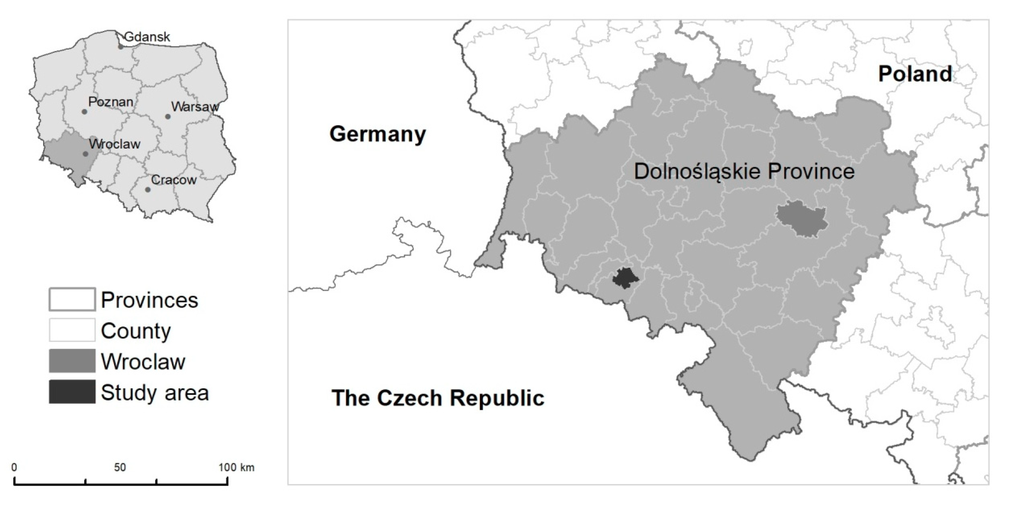
2.1. Study Area
2.2. Study Material
2.3. Land Cover Dynamics, Time Depth, and Trajectory Type Change
3. Results
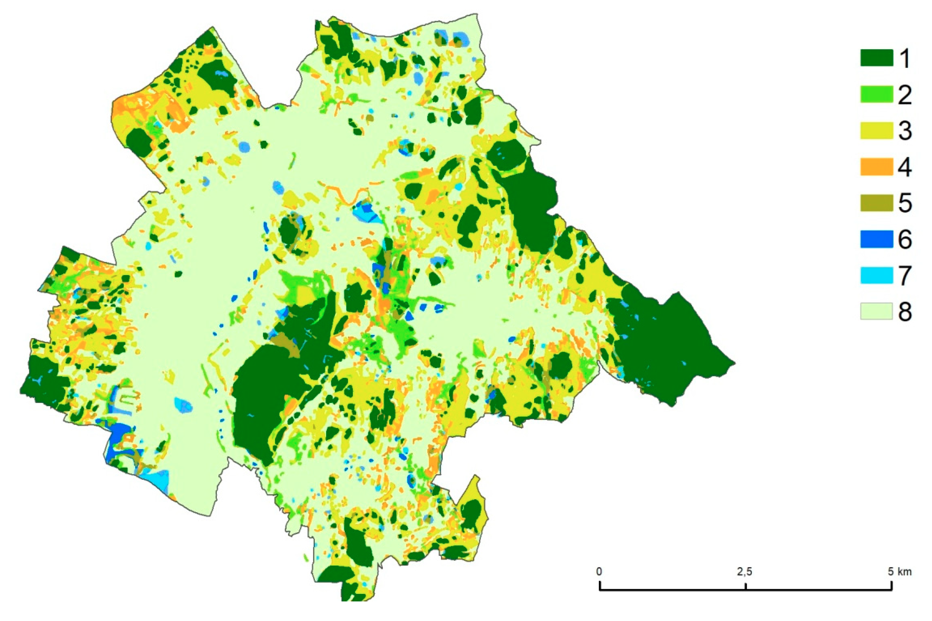
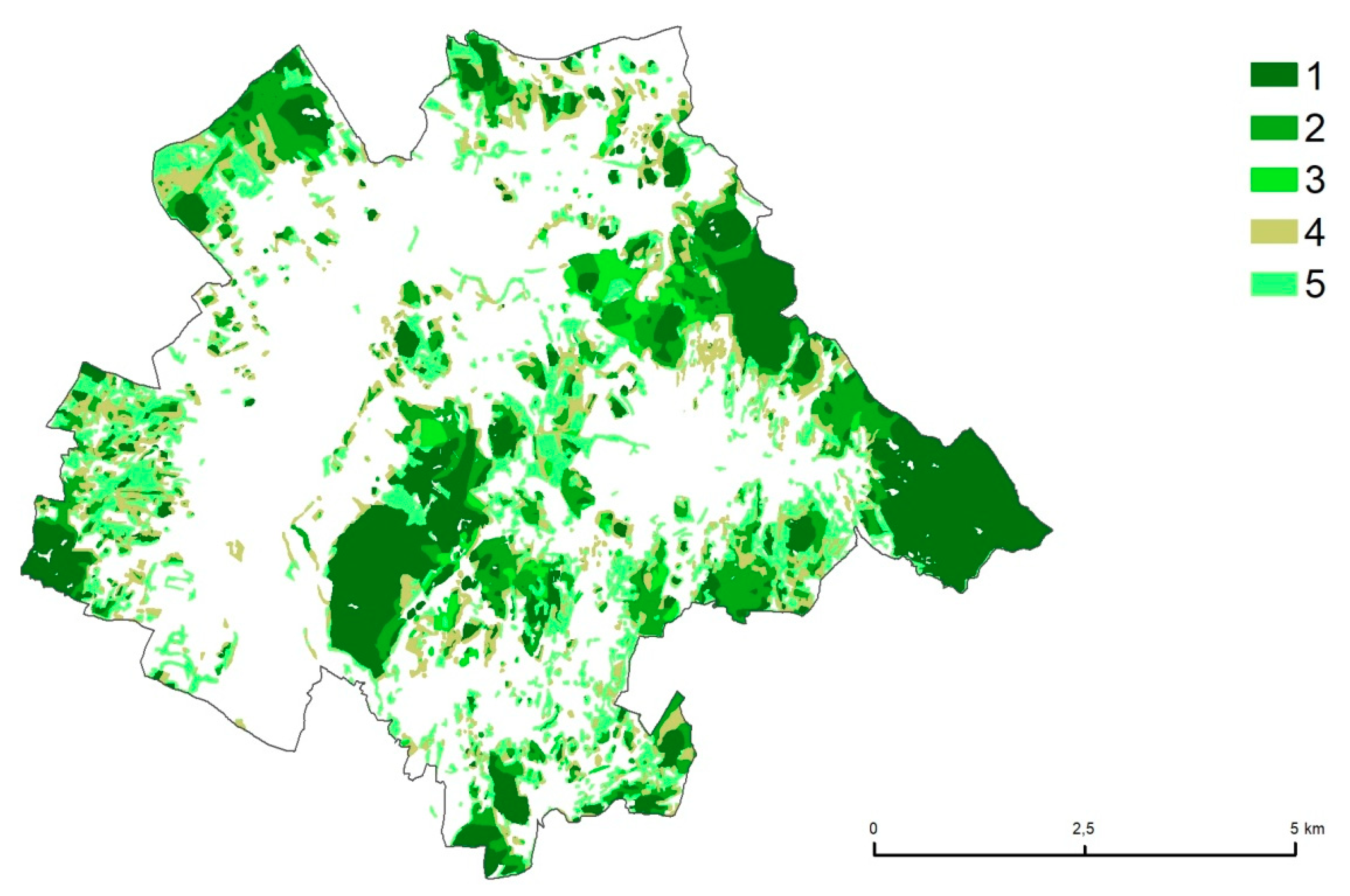
3.1. Forest Cover Trajectory Types
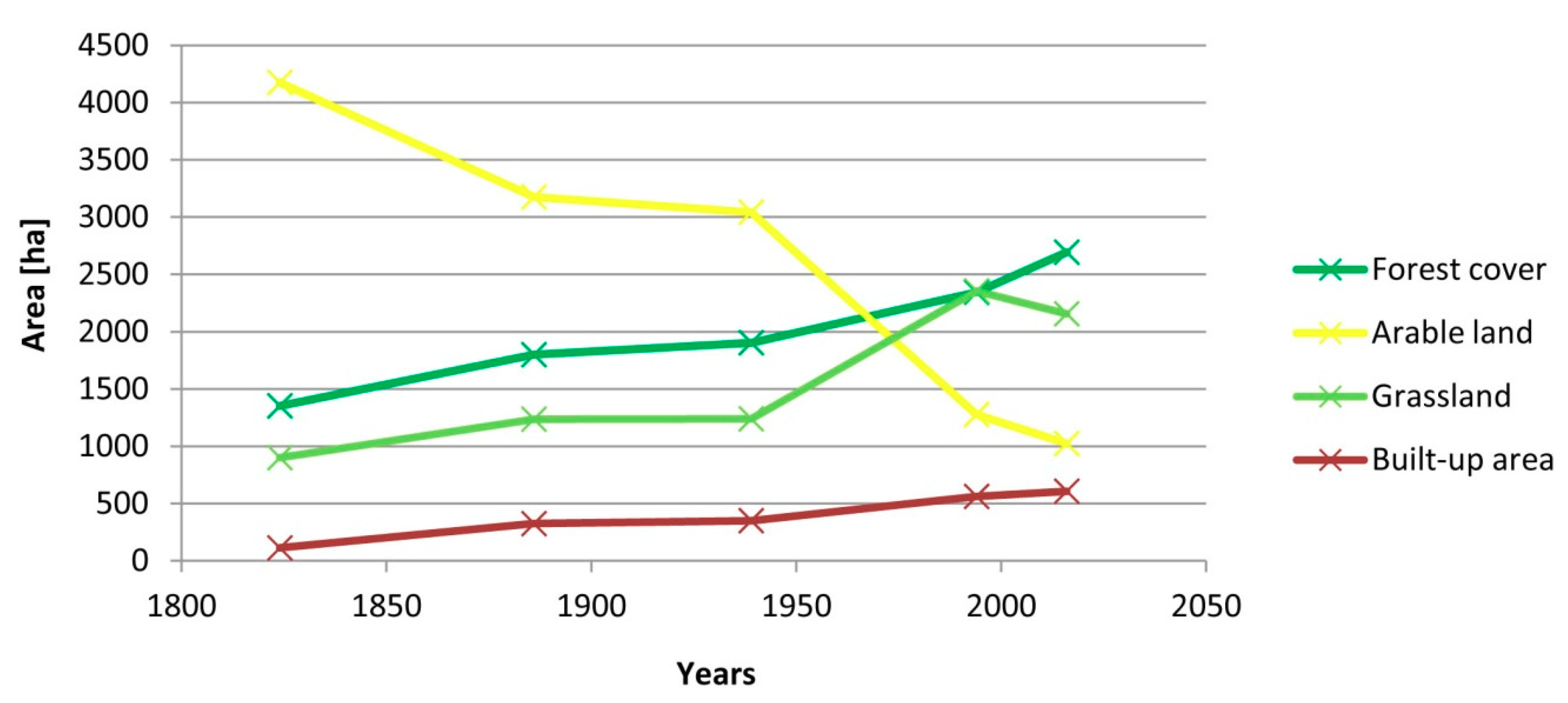
3.2. Dynamics of Land Cover between 1824 and 2016
4. Discussion
5. Conclusions
- To consider the possibility of preserving or restoring traditional coppice structure on agricultural land, with characteristic small and medium-sized tree plantings on hill tops that will contribute to emphasizing the nature of former parkland, preserving biodiversity, and boosting visual attractiveness, all of which are of importance to the tourist development of the region.
- To make use of traditional knowledge about forest management and structure when formulating optimum solutions for adapting to climate changes in the coming years.
- To shape the optimum structure for forest and agricultural landscapes to improve the quality of life of inhabitants and to provide conditions for the development of local ecological agriculture, agrotourism, and recreation.
- To undertake interdisciplinary and suprasectoral cooperation with the involvement of representatives of various scientific circles, institutions, and government authorities, as well as local communities, which will contribute to making use of knowledge about the history and cultural values of forests for purposes related to spatial planning and forest and nature management plans.
- To promote interdisciplinary studies aimed at identifying and classifying the biocultural heritage of agricultural and forest areas.
- To promote initiatives aimed at popularizing the history of traditional land use in the region among the local community members, which is of particular importance in the case of Lower Silesia, which experienced population exchange after 1945.
Supplementary Materials
Author Contributions
Funding
Conflicts of Interest
References
- Foley, J.; DeFries, R.; Asner, G.; Barford, C.; Bonan, G.; Carpenter, S.R.; Chapin, F.S.; Coe, M.T.; Daily, G.C.; Gibbs, H.K.; et al. Global consequences of land use. Science 2005, 309, 570–574. [Google Scholar] [CrossRef] [PubMed]
- Hansen, M.C.; Potapov, P.V.; Moore, R.; Hancher, M.; Turubanova, S.A.; Tyukavina, A.; Thau, D.; Stehman, S.V.; Goetz, S.J.; Loveland, T.R.; et al. High-Resolution Global Maps of 21st-Century Forest Cover Change. Science 2013, 342, 850–853. [Google Scholar] [CrossRef] [PubMed]
- Duan, Q.; Tan, M. Spatial and Temporal Variations of Forest Cover in Developing Countries. Sustainability 2019, 11, 1517. [Google Scholar] [CrossRef]
- Ren, C.; Chen, L.; Wang, Z.; Zhang, B.; Xi, Y.; Lu, C. Spatio–Temporal Changes of Forests in Northeast China: Insights from Landsat Images and Geospatial Analysis. Forests 2019, 10, 937. [Google Scholar] [CrossRef]
- Jaafar, W.S.W.M.; Maulud, K.N.A.; Kamarulzaman, A.M.M.; Raihan, A.; Sah, S.M.; Ahmad, A.; Saad, S.N.M.; Azmi, A.T.M.; Syukri, N.K.A.J.; Khan, W.R. The Influence of Deforestation on Land Surface Temperature—A Case Study of Perak and Kedah, Malaysia. Forests 2020, 11, 670. [Google Scholar] [CrossRef]
- Giles-Hansen, K.; Li, Q.; Wei, X. The Cumulative Effects of Forest Disturbance and Climate Variability on Streamflow in the Deadman River Watershed. Forests 2019, 10, 196. [Google Scholar] [CrossRef]
- FAO. State of the World’s Forests 2016. Forests and Agriculture: Land-Use Challenges and Opportunities; FAO: Rome, Italy, 2016; Available online: http://www.fao.org/publications/sofo/2016/en/ (accessed on 2 June 2020).
- FAO. The State of the World’s Forests 2018. Forest Pathways to Sustainable Development; FAO: Rome, Italy, 2018; Available online: http://www.fao.org/documents/card/en/c/I9535EN/ (accessed on 2 June 2020).
- FAO. Global Forest Resources Assessment 2020 Key Findings; FAO: Rome, Italy, 2020; Available online: http://www.fao.org/forest-resources-assessment/2020 (accessed on 22 June 2020).
- EEA Report. European Forest Ecosystems State and Trends. Ministerial Conference on the Protection of Forests in Europe Forest Europe Liaison Unit Madrid. 2015. Available online: https://foresteurope.org/state-europes-forests-2015-report/ (accessed on 22 June 2020).
- Rudel, T.K.; Coomes, O.T.; Moran, E.; Achard, F.; Angelsen, A.; Xu, J.; Lambin, L. Forest transitions: Towards a global understanding of land use change. Glob. Environ. Chang. 2005, 15, 23–31. [Google Scholar] [CrossRef]
- Southworth, J.; Nagendra, H. Reforestation: Challenges and Themes in Reforestation Research. In Reforesting Landscapes; Nagendra, H., Southworth, J., Eds.; Springer: Dordrecht, The Netherlands, 2009; Volume 10. [Google Scholar] [CrossRef]
- Conti, G.; Fagarazzi, L. Sustainable Mountain Development and the Key-Issue of Abandonment of Marginal Rural Areas. Planum 2010, 11, 1–20. [Google Scholar]
- Wolski, J. Przekształcenia krajobrazu wiejskiego bieszczadów wysokich w ciągu ostatnich 150 lat [Transformations of the High Bieszczady Mountains rural landscape during the last 150 years]. In Prace Geograficzne; Instytut Geografii i Przestrzennego Zagospodarowania PAN: Warszawa, Poland, 2007; Volume 214. [Google Scholar]
- Yarnell, T. Woods and forests in the rural landscape: Cultural heritage, conservation and management. In Managing the Historic Rural Landscape; Grenville, J., Ed.; Issues in Heritage Managment; Routledge: London, UK; New York, NY, USA; English Heritage: London, UK, 1999; pp. 101–110. [Google Scholar]
- Agnoletti, M.; Santoro, A. Cultural values and sustainable forest management: The case of Europe. J. For. Res. 2015, 20, 438–444. [Google Scholar] [CrossRef]
- Johann, E.; Agnoletti, M.; Bölöni, J.; Erol, S.Y.; Holl, K.; Kusmin, J.; Latorre, J.G.; Latorre, J.G.; Molnár, Z.; Rochel, X.; et al. Traditional Forest-Related Knowledge. Sustaining Communities, Ecosystems and Biocultural Diversity; Parrotta, J.A., Trosper, R.L., Eds.; Springer: Berlin/Heidelberg, Germany, 2012; Chapter 6; Available online: https://www.springer.com/gp/book/9789400721432 (accessed on 20 May 2020).
- Schulp, C.J.E.; Levers, C.; Kuemmerle, T.; Tieskens, K.F.; Verburg, P.H. Mapping and modelling past and future land use change in Europe’s cultural landscapes. Land Use Policy 2019, 80, 332–344. [Google Scholar] [CrossRef]
- Plieninger, T.; Höchtl, F.; Spek, T. Traditional land-use and nature conservation in European rural landscapes. Environ. Sci. Policy 2006, 9, 317–321. [Google Scholar] [CrossRef]
- Agnoletti, M.; Rotherham, I.D. Landscape and biocultural diversity. Biodivers. Conserv. 2015, 24, 3155–3165. [Google Scholar] [CrossRef]
- Agnoletti, M.; Tredici, M.; Santoro, A. Biocultural diversity and landscape patterns in three historical rural areas of Morocco, Cuba and Italy. Biodivers. Conserv. 2015, 24, 3387–3404. [Google Scholar] [CrossRef]
- Antrop, M. The concept of traditional landscapes as a base for landscape evaluation and planning. The example of Flanders Region. Landsc. Urban Plan. 1997, 38, 105–117. [Google Scholar] [CrossRef]
- Van Eetvelde, V.; Antrop, M. Analyzing structural and functional changes of traditional landscapes—Two examples from Southern France. Landsc. Urban Plan. 2004, 67, 79–95. [Google Scholar] [CrossRef]
- MCPFE (Ministerial Conference on the Protection of Forests in Europe). Forestry and Our Cultural Heritage. In Proceedings of the Seminar, Sunne, Sweden, 13–15 June 2005; Available online: https://www.foresteurope.org/documentos/heritage.pdf (accessed on 20 May 2020).
- Aronsson, M. Biocultural Heritage–the Missing Link between Culture and Nature? In Cultural Heritage and Sustainable Forest Management: The Role of Traditional Knowledge, Proceedings of the Seminar, Sunne, Sweden, 13–15 June 2005; Parrotta, J., Agnoletti, M., Johann, E., Eds.; Ministerial Conference on the Protection of Forests in Europe (MCPFE); MCPFE Liaison Unit: Warsaw, Poland, 2006; pp. 169–170. Available online: https://www.foresteurope.org/documentos/heritage.pdf (accessed on 22 July 2020).
- MCPFE (Ministerial Conference on the Protection of Forests in Europe). Vienna Declaration and Vienna Resolutions. In Proceedings of the Fourth Ministerial Conference on the Protection of Forests in Europe, Vienna, Austria, 28–30 April 2003; MCPFE Liaison Unit: Vienna, Austria, 2003. Available online: https://foresteurope.org/ministerial-conferencies/#1470845643192-a6742e05-b3397522-d58f (accessed on 20 May 2020).
- Agnoletti, M.; Anderson, S.; Johann, E.; Klein, R.; Kulvik, M.; Kushlin, A.V.; Mayer, P.; Montiel Molina, C.; Parrotta, J.; Patosaari, P.; et al. Guidelines for the implementation of social and cultural values in sustainable forest management: A scientifi c contribution to the implementation of MCPFE–Vienna Resolution 3. In IUFRO Occasional Paper No. 19; International Union of Forest Research Organizations (IUFRO): Vienna, Austria, 2007. [Google Scholar]
- Käyhkö, N.; Skånes, H. Retrospective land cover/land use change trajectories as drivers behind the local distribution and abundance patterns of oaks in south-western Finland. Landsc. Urban Plan. 2008, 88, 12–22. [Google Scholar] [CrossRef]
- Käyhkö, N.; Skånes, H. Change trajectories and key biotopes—Assessing landscape dynamics and sustainability. Landsc. Urban Plan. 2006, 75, 300–321. [Google Scholar] [CrossRef]
- Potschin, M.B.; Haines-Young, R.H. Landscapes and sustainability. Landsc. Urban Plan. 2006, 75, 155–161. [Google Scholar] [CrossRef]
- Käyhkö, N.; Fagerholm, N.; Asseid, B.S.; Mzee, A.J. Dynamic land use and land cover changes and their effect on forest resources in a coastal village of Matemwe, Zanzibar, Tanzania. Land Use Policy 2011, 28, 26–37. [Google Scholar] [CrossRef]
- Ruiz, J.; Domon, G. Analysis of landscape pattern change trajectories within areas of intensive agricultural use: Case study in a watershed of southern Québec, Canada. Landsc. Ecol. 2009, 24, 419–432. [Google Scholar] [CrossRef]
- Cousins, S.A.O. Analysis of land-cover transitions based on 17th and 18th century cadastral maps and aerial photographs. Landsc. Ecol. 2001, 16, 41–54. [Google Scholar] [CrossRef]
- Bürgi, M.; Hersperger, A.M.; Schneeberger, N. Driving forces of landscape change-current and new directions. Landsc. Ecol. 2004, 19, 857–868. [Google Scholar] [CrossRef]
- Bender, O.; Boehmer, H.J.; Jens, D.; Schumacher, K.P. Using GIS to analyse long-term cultural landscape change in Southern Germany. Landsc. Urban Plan. 2005, 70, 111–125. [Google Scholar] [CrossRef]
- Swetnam, R.D. Rural land use in England and Wales between 1930 and 1998: Mapping trajectories of change with a high resolution spatio-temporal dataset. Landsc. Urban Plan. 2005, 81, 91–103. [Google Scholar] [CrossRef]
- Frondoni, R.; Mollo, B.; Capotorti, G. A landscape analysis of land cover change in the Municipality of Rome (Italy): Spatio-temporal characteristics and ecological implications of land cover transitions from 1954 to 2001. Landsc. Urban Plan. 2011, 100, 117–128. [Google Scholar] [CrossRef]
- Johansson, L.J.; Hall, K.; Prentice, H.C.; Ihse, M.; Reitalu, T.; Sykes, M.T.; Kindström, M. Semi-natural grassland continuity, long-term land-use change and plant species richness in an agricultural landscape on Öland, Sweden. Landsc. Urban Plan. 2008, 184, 200–211. [Google Scholar] [CrossRef]
- Thompson, C.M.; Zielinski, W.J.; Purcell, K.L. Evaluating management risks using landscape trajectory analysis: A case study of California fisher. J. Wildl. Manag. 2011, 75, 1164–1176. [Google Scholar] [CrossRef]
- Pitkänen, T.P.; Mussaari, M.; Käyhkö, N. Assessing Restoration Potential of Semi-natural Grasslands by Landscape Change Trajectories. Environ. Manag. 2014, 53, 739–756. [Google Scholar] [CrossRef]
- Mertens, B.; Lambin, E.F. Land-Cover-Change Trajectories in Southern Cameroon. Ann. Assoc. Am. Geogr. 2000, 467–494. [Google Scholar] [CrossRef]
- Lambin, E.F.; Geist, H.J.; Lepers, E. Dynamics of Land-Use and Land-Cover Change in Tropical Regions. Annu. Rev. Environ. Resour. 2003, 28, 205–241. [Google Scholar] [CrossRef]
- Kennedy, R.E.; Cohen, W.B.; Schroeder, T.A. Trajectory-based change detection for automated characterization of forest disturbance dynamics. Remote Sens. Environ. 2007, 110, 370–386. [Google Scholar] [CrossRef]
- Loran, C.; Kienast, F.; Bürgi, M. Change and persistence: Exploring the driving forces of long-term forest cover dynamics in the Swiss lowlands. Eur. J. For. Res. 2018, 137, 693–706. [Google Scholar] [CrossRef]
- Skaloš, J.; Novotný, M.; Woitsch, J.; Zacharová, J.; Berchová, K.; Svoboda, M.; Křováková, K.; Romportl, D.; Keken, Z. What are the transitions of woodlands at the landscape level? Change trajectories of forest, non-forest and reclamation woody vegetation elements in a mining landscape in North-western Czech Republic. Appl. Geogr. 2015, 58, 206–216. [Google Scholar] [CrossRef]
- Malavasi, M.; Carranza, M.L.; Moravec, D.; Cutini, M. Reforestation dynamics after land abandonment: A trajectory analysisin Mediterranean mountain landscapes. Reg. Environ. Chang. 2018, 8, 2459–2469. [Google Scholar] [CrossRef]
- Van Eetvelde, V.; Antrop, M. Indicators for assessing changing landscape character of cultural landscapes in Flanders (Belgium). Land Use Policy 2009, 26, 901–910. [Google Scholar] [CrossRef]
- Van den Berghe, H.; Gheyle, W.; Stichelbaut, B.; Saey, T.; Note, N.; Van Meirvenne, M.; Bourgeois, J.; Van Eetvelde, V. Using the past to indicate the possible presence of relics in the present-day landscape: The Western Front of the Great War in Belgium. Landsc. Res. 2019, 44, 351–373. [Google Scholar] [CrossRef]
- EEA Report. European Forest Ecosystems State and Trends; Publications Office of the European Union: Luxembourg, 2016; Available online: https://www.eea.europa.eu/publications/european-forest-ecosystems (accessed on 20 May 2020).
- Forest Europe; UNECE; FAO. State of Europe’s Forests 2011. Status and Trends in Sustainable Forest Management in Europe; Forest Europe; UNECE; FAO: Oslo, Norway, 2011. [Google Scholar]
- Eiter, S.; Petthoff, K. Landscape changes in Norwegian mountains: Increased anddecreased accessibility, and their driving forces. Land Use Policy 2016, 54, 235–245. [Google Scholar] [CrossRef]
- MacDonald, D.; Crabtree, J.R.; Wiesinger, G.; Dax, T.; Stamou, N.; Fleury, P.; Gutierrez Lazpita, J.; Gibon, A. Agricultural abandonment in mountain areas of Europe: Environmental consequences and policy response. J. Environ. Manag. 2000, 59, 47–69. [Google Scholar] [CrossRef]
- Taff, G.N.; Müller, D.; Kuemmerle, T.; Ozdeneral, E.; Walsh, S.J. Reforestation in Central and Eastern Europe after the Breakdown of Socialism. In Reforesting Landscapes; Nagendra, H., Southworth, J., Eds.; Springer: Dordrecht, The Netherlands, 2009; Volume 10, pp. 121–148. Available online: https://link.springer.com/chapter/10.1007/978-1-4020-9656-3_6#citeas (accessed on 19 May 2020).
- Senetra, A.; Szczepańska, A.; Veteikis, D.; Wasilewicz-Pszczółkowska, M.; Simanauskiene, R.; Volungevicius, J. Changes of the land use patterns in Polish and Lithuanian trans-border rural area. Baltica 2013, 26, 157–168. [Google Scholar] [CrossRef]
- Alix-Garcia, J.; Munteanu, C.; Zhao, N.; Potapov, P.V.; Prishchepov, A.V.; Radeloff, V.C.; Krylov, A.; Bragina, E. Drivers of forest cover change in Eastern Europe and European Russia, 1985–2012. Land Use Policy 2016, 59, 284–297. [Google Scholar] [CrossRef]
- Cegielska, K.; Noszczyk, T.; Kukulska, A.; Szylar, M.; Hernik, J.; Dixon-Gough, R.; Jombach, S.; Valánszki, I.; Filepné Kovács, K. Land use and land cover changes in post-socialist countries: Some observations from Hungary and Poland. Land Use Policy 2018, 78, 1–18. [Google Scholar] [CrossRef]
- Potapov, P.V.; Turubanova, S.A.; Tyukavina, A.; Krylov, A.M.; McCarty, J.L.; Radeloff, V.C.; Hansen, M.C. Eastern Europe’s forest cover dynamics from 1985 to 2012 quantified from the full Landsat archive. Remote Sens. Environ. 2015, 159, 28–43. [Google Scholar] [CrossRef]
- Cvitanović, M.; Blackburn, G.A.; Rudbeck Jepsen, M. Characteristics and drivers of forest cover change in the post-socialist era in Croatia: Evidence from a mixed-methods approach. Reg. Environ. Chang. 2016, 16, 1751–1763. [Google Scholar] [CrossRef]
- Kanianska, R.; Kizeková, M.; Nováček, J.; Zeman, M. Land-use and land-cover changes in rural areas during different political systems: A case study of Slovakia from 1782 to 2006. Land Use Policy 2014, 36, 554–566. [Google Scholar] [CrossRef]
- Lieskovský, J.; Bürgi, M. Persistence in cultural landscapes: A pan-European analysis. Reg. Environ. Chang. 2018, 18, 175–187. [Google Scholar] [CrossRef]
- Kroczak, R.; Fidelus-Orzechowska, J.; Bucała-Hrabia, A.; Bryndal, T. Land use and land cover changes in small Carpathian catchments between the mid-19th and early 21st centuries and their record on the land surface. J. Mt. Sci. 2018, 15, 2561–2578. [Google Scholar] [CrossRef]
- Armaş, I.; Osaci-Costache, G.; Braşoveanu, L. Forest Landscape History Using Diachronic Cartography and GIS. Case Study: Subcarpathian Prahova Valley, Romania. In Planning and Designing Sustainable and Resilient Landscapes; Crâciun, C., Bostenaru Dan, M., Eds.; Springer: Dordrecht, The Netherlands, 2014; pp. 73–86. [Google Scholar] [CrossRef]
- Kolecka, N.; Kozak, J.; Kaim, D.; Dobosz, M.; Ostafin, K.; Ostapowicz, K.; Wężyk, P.; Price, B. Understanding farmland abandonment in the Polish Carpathians. Appl. Geogr. 2017, 88, 62–72. [Google Scholar] [CrossRef]
- Poławski, Z. Zmiany użytkowania ziemi w Polsce w ostatnich dwóch stuleciach [Land use changes in Poland during last two centuries]. Teledetekcja Środowiska 2009, 42, 69–82. [Google Scholar]
- Antrop, M. Why landscapes of the past are important for the future. Landsc. Urban Plan. 2005, 70, 21–34. [Google Scholar] [CrossRef]
- Palang, A.; Spek, T.; Stenseke, M. Digging in the past: New conceptual models in landscape history and their relevance in peri-urban landscapes. Landsc. Urban Plan. 2011, 100, 344–346. [Google Scholar] [CrossRef]
- Kozak, J. Forest Cover Changes and Their Drivers in the Polish Carpathian Mountains since 1800. In Reforesting Landscapes; Nagendra, H., Southworth, J., Eds.; Springer: Dordrecht, The Netherlands, 2009; Volume 10, pp. 253–274. [Google Scholar] [CrossRef]
- Augustyn, M. Anthropogenic changes in the environmental parameters of Bieszczady Mountains. Biosph. Conserv. 2004, 6, 43–53. [Google Scholar]
- Gielarek, S.; Klich, D.; Antosiewicz, M. Zmiany powierzchni leśnej w Bieszczadach Zachodnich w XIX i XX wieku [Forest cover change in Western Bieszczady Mts. in 19th and 20th century]. Sylwan 2011, 155, 835–842. [Google Scholar] [CrossRef]
- Kardaś, P. Zastosowanie telegeoinformacji w badaniach zmian pokrycia terenu Magurskiego Parku Narodowego w latach 1935–1999, Fotointerpretacja w Geografii [Use of telegeoinformation in studies of land cover changes in Magurski National Park in the years 1935–1999]. Probl. Telegeoinformacji 2000, 31, 82–90. [Google Scholar]
- Woś, B. Zmiany pokrycia terenu w wybranych gminach Beskidów w drugiej połowie XX w. na podstawie analizy zdjęć lotniczych [Changes in land cover in selected Beskid Mountains communes in the second half of the 20th c. on the basis of analysis of aerial photographs]. Teledetekcja Środowiska 2005, 35, 1–114. [Google Scholar]
- Latocha, A. Przemiany środowiska przyrodniczego w Sudetach Wschodnich w warunkach antropopresji [Transformations of the natural environment in the Eastern Sudeten Mountains]. In Studia Geograficzne Uniwersytetu Wrocławskiego 80; Wydawnictwo Uniwersytetu Wrocławskiego: Wrocław, Poland, 2007; p. 216. [Google Scholar]
- Szymura, T.H.; Dunajski, A.; Ruczakowska, A.M. Zmiany powierzchni lasów na obszarze Karkonoskiego Parku Narodowego w okresie 1747–1977 [Changes of forest cover in the Karkonosze National Park area in 1747–1977 period]. Opera Corcon. 2010, 47, 159–166. [Google Scholar]
- Wolski, J. Następstwa zaniku antropopresji na obszarach górskich–dyskusja zależności „proces a region”w ujęciu różnoskalowym [Consequences of the disappearance of human impact from mountainous areas–a discussion of “process vs. region” relationships as conceptualized on various scales]. Przegląd Geogr. 2009, 81, 47–73. [Google Scholar]
- Krajewski, P.; Solecka, I.; Mrozik, K. Forest Landscape Change and Preliminary Study on Its Driving Forces in Ślęża Landscape Park (Southwestern Poland) in 1883–2013. Sustainability 2018, 10, 4526. [Google Scholar] [CrossRef]
- Kuriata, Z.; Kołaczkiewicz, E.; Moździoch, S.; Przerwa, T.; Seidel-Grzesińska, A.; Stanicka-Brzezicka, K.; Wyrzykowska, M.; Bereś, A.; Nowopolska-Szczyglewska, A.; Pacześniak, A. Program Opieki Nad Zabytkami Województwa Dolnośląskiego Na Lata 2015–2018 [Programme for the Protection of Historical Monuments of the Lower Silesian Voivodeship for 2015–2018]; Centrum Monitoringu Społecznego i Kultury Obywatelskiej, Urząd Marszałkowski Województwa Dolnośląskiego: Wroclaw, Poland, 2014. [Google Scholar]
- Migoń, P.; Latocha, A. Enhancement of cultural landscape by geomorphology. A study of granite parklands in the West Sudetes, SW Poland. Geogr. Fis. Din. Quat. 2008, 31, 195–203. [Google Scholar]
- Kwaśny, Z. Jelenia Góra. Zarys Rozwoju Miasta [Jelenia Góra. On Outline of the City’s Development]; Zakład Narodowy im. Ossolińskich: Wrocław, Poland, 1989. [Google Scholar]
- Walczak, W. Sudety [The Sudetes]; PWN: Warszawa, Poland, 1968. [Google Scholar]
- Boratyński, A. Chorologiczna Analiza Flory Drzew i Krzewów Sudetów Zachodnich [Chorological Analysis of the Flora of Trees and Shrubs of the West Sudetes]; The Polish Academy of Sciences, Institute of Dendrology: Kórnik, Poland, 1991. [Google Scholar]
- BDL. State Forest-Forest Data Bank; BDL: Warszawa, Poland, 2019. [Google Scholar]
- Zielony, R.; Kliczkowska, A. Regionalizacja przyrodniczo-leśna Polski 2010. [Regionalization of natural-forest Polish 2010]; CILP: Warszawa, Poland, 2012. [Google Scholar]
- Matuszkiewicz, W.Ł. Przewodnik do Oznaczania Zbiorowisk Roślinnych Polski [A Guide to Identification of the Plant Communities of Poland]; PWN: Warszawa, Poland, 2017. [Google Scholar]
- Ratajski, J. Ochrona przyrody w województwie jeleniogórskim–parki krajobrazowe i rezerwaty przyrody [Environmental protection in Jeleniogórskie Province–landscape parks and natural reserves]. In Rocznik Jeleniogórski; tom XXIX, Towarzystwo Przyjaciół Jeleniej Góry [Society of Friends of the City of Jelenia Góra]; Zakład Narodowy im. Ossolińskich: Wrocław, Poland, 1997; pp. 136–151. [Google Scholar]
- Jaworek, J. Kotlina Jeleniogórska [Jeleniogórska Basin: As cultural landscape of Lenné]. In The Gardens of Peter Joseph Lenné in Present-Day Poland; Köhler, M., Haase, C., Eds.; Edition GartenReich-Bd. 2; Verlag Janos Stekovics: Wettin-Löbejün, Germany, 2016; pp. 26–40. [Google Scholar]
- Antrop, M.; Van Eetvelde, V. Landscape Perspectives: The Holistic Nature of Landscape; Landscape Series 23; Springer: Dordrecht, The Netherlands, 2017; p. 372. [Google Scholar] [CrossRef]
- Van Eetvelde, V.; Käyhkö, N. The applicability of quantitative techniques for assessing spatio-temporal patterns of landscape changes. In Proceedings of the 70 Years of Landscape Ecology in Europe Salzburg European Landscapes in Transformation: Challenges for Landscape Ecology and Management, Salzburg, Austria, 12–16 July 2009; Breuste, J., Kozová, M., Finka, M., Eds.; University of Salzburg: Salzburg, Austria, 2009; pp. 379–382. [Google Scholar]
- Agnoletti, M. The development of a historical and cultural evaluation approach in landscape assessment: The dynamic of Tuscan Landscape between 1832 and 2004. In The Conservation of Cultural Landscapes; Agnoletti, M., Ed.; University of Florence: Florence, Italy; CABI: Wallingford, UK, 2006; pp. 3–30. [Google Scholar]
- Simoniello, T.; Coluzzi, R.; Imbrenda, V.; Lanfredi, M. Land cover changes and forest landscape evolution (1985–2009) in a typical Mediterranean agroforestry system (high Agri Valley). Nat. Hazards Earth Syst. Sci. 2015, 15, 1201–1214. [Google Scholar] [CrossRef]
- Rubiano, K.; Clerici, N.; Norden, N.; Etter, A. Secondary Forest and Shrubland Dynamics in a Highly Transformed Landscape in the Northern Andes of Colombia (1985–2015). Forests 2017, 8, 216. [Google Scholar] [CrossRef]
- Clark, J.; Darlington, J.; Fairclough, G. Using Historic Landscape Characterisation: English Heritage’s Review of HLC Applications 2002-03; English Heritage; Lancashire County Council: London, Preston, UK, 2004.
- Latocha, A. Rozwój krajobrazu Sudetów Kłodzkich w czasach historycznych [Changes in land use in historical times and their impact on land relief processes on slopes and in river beds in the Kłodzkie Sudetes]. In Problemy Ekologii Krajobrazu, Struktura Przestrzenno-Funkcjonalna Krajobrazu; Szponar, A., Horska–Schwarz, S., Eds.; Uniwersytet Wrocławski: Wrocław, Poland, 2005; pp. 140–149. [Google Scholar]
- Nyrek, A. Gospodarka Leśna na Górnym Śląsku: Od pol. XVII do pol. XIX w. [Forest Economy in Upper Silesia from the Mid-17th c. to the Mid-19th c.]; Zakład Narodowy im. Ossolińskich: Wrocław, Poland, 1975. [Google Scholar]
- Janczak, J. Człowiek i Przyroda: Przegląd Zmian w Środowisku Geograficznym Śląska w Ostatnim Tysiącleciu [Humans and Nature: A Review of Changes in the Geographical Environment in Silesia during the Last Millenium]; Dolnośląskie Tow. Społeczno-kulturalne: Wrocław, Poland, 1985. [Google Scholar]
- Pająkiewicz, J. Strukturalne Przemiany w Rolnictwie Województwa Jeleniogórskiego w Latach 1975–1981 [Structural Transformations in Agriculture in Jeleniogórskie Province in the Years 1975–1981]; Prace Karkonoskiego Towarzystwa Naukowego, Komisja Ekonomiczna [Economic Committee]: Jelenia Góra, Poland, 1983; Volume 33, pp. 161–177. [Google Scholar]
- Trocka-Leszczyńska, E. Wiejska Zabudowa Mieszkaniowa w Regionie Sudeckim [Rural Residential Houses in the Sudeten Region]; Oficyna Wydawnicza Politechniki Wrocławskiej: Wrocław, Poland, 1995. [Google Scholar]
- Staffa, M. Historia poznania Karkonoszy oraz rozwój osadnictwa [History of acquisition of knowledge about the Giant Mountains and the development of settlement]. In Karkonosze. Przyroda Nieożywiona i Człowiek [The Giant Mountains. Inanimate Nature and Humans]; Mierzejewski, M.P., Ed.; Wydawnictwo Uniwersytetu Wrocławskiego: Wrocław, Poland, 2005; pp. 23–51. [Google Scholar]
- Nietupski, T. Rolnictwo [Agriculture]. In Przyroda Dolnego Śląska [Nature in Lower Silesia]; Fabiszewski, J., Ed.; Polska Akademia Nauk–Oddział we Wrocławiu: Wrocław, Poland, 2005; pp. 391–410. [Google Scholar]
- Latocha, A. Zmiany krajobrazu wiejskiego w Sudetach w okresie powojennym [Changes in rural landscape in the Sudetes in the post-war period]. In Polskie Krajobrazy Wiejskie Dawne I Współczesne [Past and Contemporary Polish Rural Landscapes]; Prace Komisji Krajobrazu Kulturowego, Komisja Krajobrazu Kulturowego PTG: Sosnowiec, Poland, 2009; Volume 12, pp. 130–138. [Google Scholar]
- Bičik, I.; Štĕpánek, V. Post-war changes of land-use structure in Bohemia and Moravia: Case study Sudetenland. GeoJournal 1994, 32, 253–259. [Google Scholar] [CrossRef]
- Kozak, J.; Estreguil, C.; Troll, M. Forest cover changes in the northern Carpathians in the 20th century: A slow transition. J. Land Use Sci. 2007, 2, 127–146. [Google Scholar] [CrossRef]
- Leuschner, C.; Ellenberg, H. Environmental and Historical Influences on the Vegetation of Central Europe. In Ecology of Central European Forests; Springer: Cham, Switzerland, 2017. [Google Scholar] [CrossRef]
- Filipiak, M. Life of Abies alba (Pinaceae) under the conditions of intense anthropopressure in the Sudety Mountains. Fragm. Florist. Geobot. Pol. 2006, 13, 113–138. [Google Scholar]
- Agnoletti, M.; Parotta, J.A. Traditional Forest-Related Knowledge and Climate Change. Sustaining Communities, Ecosystems and Biocultural Diversity; Parrotta, J.A., Trosper, R.L., Eds.; Springer: Berlin/Heidelberg, Germany, 2012; Chapter 13; Available online: https://www.springer.com/gp/book/9789400721432 (accessed on 22 July 2020).
- Van Benthem, M.; Jansen, P. Management of Historic Elements in Dutch Forests. In Forestry and Our Cultural Heritage, Proceedings of the Seminar, Sunne, Sweden, 13–15 June 2005; MCPFE Liaison Unit: Warsaw, Poland, 2006; pp. 77–81. Available online: https://www.foresteurope.org/documentos/heritage.pdf (accessed on 22 July 2020).
- Jaworek-Jakubska, J.; Filipiak, M.; Michalski, A.; Napierała-Filipiak, A. Spatio-temporal changes of urban forests and planning evolution in a highly dynamical urban area: The case study of Wrocław, Poland. Forests 2020, 11, 17. [Google Scholar] [CrossRef]


| Material | Year | Scale | Source |
| Topographic map (Urmesstischblatt) | T1: 1824 | 1:25,000 | Berlin State Library, Germany |
| Topographic map (Messtischblatt) | T2: 1886 | 1:25,000 | Berlin State Library, Germany |
| Topographic map (Messtischblatt) | T3: 1939 | 1:25,000 | Berlin State Library, Germany |
| Orthophoto map | T4: 1994 | - | Provincial Centre for Geodesic and Cartographic Documentation, Poland |
| Orthophoto map | T5: 2016 | - | Head Office of Head Office of Land Surveying and Cartography, Poland |
| Additional Sources of Data | Year | Scale | Source |
| Aerial photo | 1937 | 1:25,000 | Herder Institute in Marburg, Germany |
| Polish topographic map | 1998 | 1:10,000 | Provincial Centre for Geodesic and Cartographic Documentation |
| Topographic Cartographic Database (BDOT10k) | 2013 | - | Head Office of Land Surveying and Cartography |
| Forest Cover Trajectory Types | [%] | Description | Example * | |
|---|---|---|---|---|
| 1 | Long-term stability | 16.4 | Long term forest cover without change | AAAAA |
| 2 | Single increase of forest cover from grassland | 3.1 | One point of change between forest and grassland; stable land cover before and after this point | BAAAA BBBAA |
| 3 | Single increase of forest cover from arable land | 14.4 | One point of change between forest and arable land with stable land cover before and after this point | CAAAA CCAAA |
| 4 | Dynamic increase of forest cover from mixed agricultural land | 6.1 | Many changes between many different land cover classes (grassland, arable land, and built-up area); no trend is strong enough | BCBBA BAACA |
| 5 | Cyclical increase of forest cover | 1.3 | Cyclical change rotation between forest and grassland or forest and arable land | ABBAA ACCAA |
| 6 | Single decrease of forest cover into grassland | 1.9 | One point of change between forest and grassland with stable land cover before and after this point | ABBBB AABBB |
| 7 | Dynamic decrease of forest cover into mixed agricultural land | 1.1 | Many changes between many different land cover classes (grassland, arable land, and built-up area); no trend is strong enough | ACBCC AACCB |
| 8 | Areas where occurrence of forest has never been recorded during the investigated period | 55.7 | Grassland, arable land or built up area | - |
| Land Cover Type | T1 | T2 | T3 | T4 | T5 | ||||||
|---|---|---|---|---|---|---|---|---|---|---|---|
| [ha] | [%] | [ha] | [%] | [ha] | [%] | [ha] | [%] | [ha] | [%] | ||
| A | Forest cover | 1352.0 | 20.7 | 1798.8 | 27.50 | 1903.4 | 29.1 | 2345 | 35.9 | 2693 | 41.2 |
| Coniferous | - | - | 686.3 | 10.5 | 764.7 | 11.7 | 119.9 | 1.8 | 113.3 | 1.7 | |
| Deciduous | - | - | 218.0 | 3.3 | 205.6 | 3.1 | 307.5 | 4.7 | 555.5 | 8.5 | |
| Mixed | - | - | 894.5 | 13.7 | 933.1 | 14.3 | 1917 | 29.3 | 2024 | 31.0 | |
| B | Arable land | 4175.3 | 63.9 | 3175.1 | 48.6 | 3043.2 | 46.6 | 1277 | 19.5 | 1024 | 15.7 |
| C | Grassland | 900.2 | 13.8 | 1236.1 | 18.9 | 1239.4 | 19.0 | 2355 | 36 | 2156 | 33.8 |
| D | Built-up area | 112.5 | 1.7 | 324.23 | 5 | 350.6 | 5.36 | 562.1 | 8.6 | 607.9 | 9.3 |
| Land Cover Type | T1–T2 | T2–T3 | T3–T4 | T4–T5 | |
|---|---|---|---|---|---|
| A | Forest cover | 7.21 | 1.97 | 8.02 | 15.85 |
| Coniferous | - | 1.48 | −11.72 | −0.30 | |
| Deciduous | - | −0.23 | 1.85 | 11.27 | |
| Mixed | - | 0.73 | 17.89 | 4.88 | |
| B | Arable land | −16.13 | −2.49 | −32.11 | −11.50 |
| C | Grassland | 5.42 | 0.06 | 20.29 | −9.04 |
| D | Built-up area | 3.42 | 0.50 | 3.85 | 2.08 |
| Area in 1886 | ||||||||||||
| Forests | Grassland | Arable Land | Built-Up Area | Total Area 1824 | Loss | |||||||
| Area in 1824 | ha | % | ha | % | ha | % | ha | % | ha | % | ha | % |
| Forest | 1119.8 | 17.1 | 97.5 | 1.5 | 136.7 | 2.1 | 0.0 | 0.0 | 1354.0 | 20.7 | 234.23 | 3.6 |
| Grassland | 107.9 | 1.7 | 502.7 | 7.7 | 225.3 | 3.5 | 65.4 | 1.0 | 901.3 | 13.8 | 398.6 | 6.1 |
| Arable land | 574.8 | 8.8 | 619.6 | 9.5 | 2768.3 | 42.4 | 214.0 | 3.3 | 4176.7 | 63.9 | 1408.4 | 21.5 |
| Built-up area | 0.00 | 0.00 | 17.8 | 0.3 | 48.0 | 0.7 | 45.0 | 0.7 | 110.9 | 1.7 | 65.9 | 1.0 |
| Total area 1886 | 1802.5 | 27.6 | 1237.7 | 18.9 | 3178.4 | 48.6 | 324.4 | 5.0 | ||||
| Gain | 682.7 | 10.4 | 734.9 | 11.3 | 410.1 | 6.3 | 279.4 | 4.3 | ||||
| Area in 1930 | ||||||||||||
| Forests | Grassland | Arable Land | Built-Up Area | Total Area 1886 | Loss | |||||||
| Area in 1886 | ha | % | ha | % | ha | % | ha | % | ha | % | ha | % |
| Forest | 1761.8 | 27.0 | 26.5 | 0.4 | 12.0 | 0.2 | 0.2 | 0.0 | 1800.2 | 27.5 | 38.68 | 0.6 |
| Grassland | 25.1 | 0.4 | 1169.8 | 17.9 | 36.8 | 0.6 | 2.8 | 0.0 | 1234.6 | 18.9 | 64.7 | 1.0 |
| Arable land | 112.7 | 1.7 | 38.8 | 0.6 | 2998.4 | 45.9 | 27.7 | 0.4 | 3177.7 | 48.6 | 179.3 | 2.7 |
| Built-up area | 0.0 | 0.0 | 3.8 | 0.1 | 6.0 | 0.1 | 319.9 | 4.9 | 329.7 | 5.0 | 9.8 | 0.2 |
| Total area 1930 | 1899.5 | 29.1 | 1238.9 | 19.0 | 3047.3 | 46.7 | 350.6 | 5.4 | ||||
| Gain | 137.8 | 2.1 | 69.1 | 1.0 | 54.8 | 0.8 | 30.8 | 0.5 | ||||
| Area in 1996 | ||||||||||||
| Forests | Grassland | Arable Land | Built-Up Area | Total Area 1930 | Loss | |||||||
| Area in 1930 | ha | % | ha | % | ha | % | ha | % | ha | % | ha | % |
| Forest | 1858.2 | 28.4 | 32.0 | 0.5 | 8.7 | 0.1 | 1.3 | 0.0 | 1900.2 | 29.1 | 42.09 | 0.6 |
| Grassland | 136.5 | 2.1 | 868.0 | 13.3 | 175.0 | 2.7 | 64.1 | 1.0 | 1243.6 | 19.0 | 375.6 | 5.8 |
| Arable land | 352.4 | 5.4 | 1374.5 | 21.0 | 1082.6 | 16.6 | 236.3 | 3.6 | 3045.8 | 46.6 | 1963.2 | 30.0 |
| Built-up area | 1.4 | 0.02 | 78.6 | 1.2 | 8.9 | 0.1 | 261.3 | 4.0 | 350.2 | 5.4 | 88.9 | 1.4 |
| Total area 1996 | 2348.5 | 35.9 | 2353.2 | 36.0 | 1275.1 | 19.5 | 563.1 | 8.6 | ||||
| Gain | 490.3 | 7.5 | 1485.2 | 22.7 | 192.6 | 3.0 | 301.7 | 4.6 | ||||
| Area in 2016 | ||||||||||||
| Forests | Grassland | Arable Land | Built-Up Area | Total Area 1996 | Loss | |||||||
| Area in 1996 | ha | % | ha | % | ha | % | ha | % | ha | % | ha | % |
| Forest | 2291.8 | 35.1 | 51.5 | 0.8 | 1.9 | 0.0 | 1.0 | 0.0 | 2346.2 | 35.9 | 54.38 | 0.8 |
| Grassland | 339.1 | 5.2 | 1951.1 | 29.9 | 29.1 | 0.4 | 35.4 | 0.5 | 2354.7 | 36.0 | 403.6 | 6.2 |
| Arable land | 60.4 | 0.9 | 207.9 | 3.2 | 978.6 | 15.0 | 27.8 | 0.4 | 1274.7 | 19.5 | 296.1 | 4.5 |
| Built-up area | 0.5 | 0.01 | 1.1 | 0.02 | 19.6 | 0.3 | 544.2 | 8.3 | 565.4 | 8.6 | 21.2 | 0.3 |
| Total area 2016 | 2691.9 | 41.2 | 2211.6 | 33.8 | 1029.1 | 15.7 | 608.4 | 9.3 | ||||
| Gain | 400.0 | 6.1 | 260.5 | 4.0 | 50.5 | 0.8 | 64.2 | 1.0 | ||||
| Time Period | Unchanged [%] | Changed [%] | Binary Changed Index |
|---|---|---|---|
| 1824–1886 | 67.9 | 32.2 | 0.4 |
| 1886–1939 | 95.6 | 4.4 | 0.9 |
| 1939–1994 | 62.3 | 37.8 | 0.2 |
| 1994–2016 | 88.2 | 11.9 | 0.8 |
© 2020 by the authors. Licensee MDPI, Basel, Switzerland. This article is an open access article distributed under the terms and conditions of the Creative Commons Attribution (CC BY) license (http://creativecommons.org/licenses/by/4.0/).
Share and Cite
Jaworek-Jakubska, J.; Filipiak, M.; Napierała-Filipiak, A. Understanding of Forest Cover Dynamics in Traditional Landscapes: Mapping Trajectories of Changes in Mountain Territories (1824–2016), on the Example of Jeleniogórska Basin, Poland. Forests 2020, 11, 867. https://doi.org/10.3390/f11080867
Jaworek-Jakubska J, Filipiak M, Napierała-Filipiak A. Understanding of Forest Cover Dynamics in Traditional Landscapes: Mapping Trajectories of Changes in Mountain Territories (1824–2016), on the Example of Jeleniogórska Basin, Poland. Forests. 2020; 11(8):867. https://doi.org/10.3390/f11080867
Chicago/Turabian StyleJaworek-Jakubska, Justyna, Maciej Filipiak, and Anna Napierała-Filipiak. 2020. "Understanding of Forest Cover Dynamics in Traditional Landscapes: Mapping Trajectories of Changes in Mountain Territories (1824–2016), on the Example of Jeleniogórska Basin, Poland" Forests 11, no. 8: 867. https://doi.org/10.3390/f11080867
APA StyleJaworek-Jakubska, J., Filipiak, M., & Napierała-Filipiak, A. (2020). Understanding of Forest Cover Dynamics in Traditional Landscapes: Mapping Trajectories of Changes in Mountain Territories (1824–2016), on the Example of Jeleniogórska Basin, Poland. Forests, 11(8), 867. https://doi.org/10.3390/f11080867