Article

Fragmentation and Connectivity of Island Forests in Agricultural Mediterranean Environments: A Comparative Study between the Guadalquivir Valley (Spain) and the Apulia Region (Italy)

by
Pablo J. Hidalgo
1,*,
Helena Hernández
1,
Antonio J. Sánchez-Almendro
1,
Javier López-Tirado
1,
Federico Vessella
2 and
Rafael Porras
3
1
RENSMA Research Center, Department of Integrative Sciences, Faculty of Experimental Sciences, University of Huelva, Avda. Tres de Marzo s/n, 21071 Huelva, Spain
2
Department of Agricolture and Forestry (DAFNE), Università Degli Studi della Tuscia, Via San Camillo de Lellis, snc, 01100 Viterbo, Italy
3
Biogeos, Estudios Ambientales, SL. Parque Científico Tecnológico Rabanales 21, 14014 Córdoba, Spain
*
Author to whom correspondence should be addressed.
Forests 2021, 12(9), 1201; https://doi.org/10.3390/f12091201
Submission received: 14 July 2021 / Revised: 18 August 2021 / Accepted: 31 August 2021 / Published: 3 September 2021

Abstract

:
Habitat loss and fragmentation are considered some the main threats to biodiversity. Original forests have suffered an accentuated fragmentation and agricultural homogenization, leaving only some areas of natural vegetation, relegated to strongly anthropized disconnected patches (island forests, IFs) in a hostile matrix. These patches of original vegetation could be the key for the design and management of ecological corridors to promote species migration, an essential strategy for meeting the consequences of Global Change. This study proposes a comparative analysis of the fragmentation and connectivity of IFs of Quercus in two typically Mediterranean areas of predominantly agricultural use: the Guadalquivir valley (Spain) and the Apulia region (Italy). A retrospective comparison is also carried out in the Guadalquivir valley. The aim is to develop an objective new methodology to locate the patches of most interest using quantitative and qualitative data. Reference cartography of current island forests of Quercus species was developed from several digital sources and validated with orthoimages and field observations. Fragmentation analysis was based on graph structures using the software Conefor 2.6, a reliable tool for assessment of the role of patches in the landscape. Area and distance were used as node and connector values. Dispersion distance was established as 500 m, based on the maximum dispersion of acorns. Results indicate that the Guadalquivir valley has suffered an intensive fragmentation in recent decades. Both the Guadalquivir and Apulia regions host some IFs with the relevant potential to contribute as core habitats in the creation of connections to other natural protected sites. Many residual IFs in the landscape could contribute as stepping stones in the design and management of ecological corridors. Our methodology highlights the value of IFs to develop assessment strategies using homogenized available digital cartography and common criteria for the dispersion distances in graph theory analysis. The application of this new methodology could help in the management of protected sites using highly fragmented areas to allow the species movement through inhospitable landscapes in a unique opportunity to connect the different protected areas.

1. Introduction

The processes of reduction and fragmentation of habitats are considered by the scientific community as one of the main threats to biodiversity [1,2]. This biodiversity loss makes an ecosystem less resilient, and thus less capable of tolerating disturbances. In addition, it could impact economic processes affecting human well-being, since biodiversity is essential for many elements of ecosystem services [3,4].
Species are distributed according to the spatial variation of the environmental conditions that characterize the habitats they occupy. Natural disasters, such as floods or wildfires, among many other natural phenomena, modify the structure of the territory, creating a heterogeneous landscape. Other environmental variables such as topography, lithology, edaphology, etc., can also contribute to the landscape heterogeneity. However, from a conservationist point of view, it is not this gradual change in the natural landscape which concerns managers, but rather the increasing capacity of human activity to transform the environment. It is seriously affecting the normal functioning of natural systems. Human activity has been modifying land cover for approximately 10,000 years, with early forest clearing for the subsequent installation of crops and pastures. This transformation has been intensified by the industrial revolution since the latter part of the 18th century [5] and the development of heavy machinery, capable of transforming large areas in a short period. Such has been the severity of this influence that Crutzen and Stoermer [5] proposed a new geological era called the Anthropocene, to indicate the power that humanity has had over the basic processes of the biosphere.
In recent decades, this transformation has been very intense in western Europe: the original forests that made up the European landscape have suffered an accentuated fragmentation and agricultural homogenization, leaving only some areas of natural vegetation, relegated to strongly anthropized disconnected patches in a hostile matrix [6,7,8] sufficiently permeable to allow animal movements or plant dispersion. These losses of forest cover are more common in meadows, valleys and plateaus, as they are accessible areas with higher productivity. In other areas of Western Europe, many sites previously dedicated to agriculture have shown a clear recovery in recent times, so this phenomenon of land use change and fragmentation has not been generalized throughout the continent [9,10]. Such sites are basically ancient agricultural areas of low productivity characterised by a particular relief that makes mechanization difficult, and are consequently less profitable for agriculture.
Fragmentation refers to the progressive change in landscape by which a given habitat, usually forests, is reduced to smaller patches or island forests, enclosed within a hostile matrix with a land use different than the original one. The negative consequences of this change can be summarized as [1,11,12]: (i) a reduction in the amount of available habitat, and therefore, a lower population size of the species; (ii) a decrease in the average size and an increase in the number of habitat fragments; (iii) the isolation of the resulting fragments, limiting the exchange of individuals between separate patches; and (iv) a higher perimeter/surface ratio among the patches and hence greater exposure and permeability to the negative effects of surrounding land uses, known as the edge effect [8].
The results of this fragmentation and isolation are residual areas, generally known as Island Forests (IFs) where the original ecosystem was a forest. According to the theory of island biogeography [13,14], there are unconnected patches of the original habitat (islands) embedded in a matrix (sea) very different from the original one (Figure 1).
The conservation of hedges, fences, boundaries, IFs, etc. in these transformed landscapes is a key factor for the following reasons:
  • They favour the maintenance of biological richness and biodiversity. They contribute to the knowledge and characterization of the potential vegetation in those territories with a marked alteration [15].
  • IFs are an important core for ecological succession in the recovery of some areas of abandoned cultivation, and/or the creation of ecological corridors allowing species flow through the landscape [16].
  • They are patches of mature ecosystems providing heterogeneity and the maintenance of ecological processes in the landscape [17,18], and playing a substantial role in pest control and serving as a refuge for wildlife [19].
Apart from these reasons, there is the need to address a new threat to the biosphere: global change. This proposed human-induced phenomenon is driving species in a process known as poleward (latitudinal) and upward (altitudinal) migration [20,21]. Range shift could be especially severe in overexploited and degraded habitats, as the speed of the shift may be too fast for the dispersal capacity of many species. In this context, high latitude and high mountain forests will be seriously affected due to the absence of available territories into which they can migrate [22]. Stenoic and low dispersal capacity species would require a specific management to face this fast shift [23]. One proposed solution is benign introduction, a particular type of intentional introduction aimed at establishing a new population of an endangered species outside its recorded historical range to favor its conservation without causing ecological damage [24]. Other solutions involve the management of the landscape to facilitate the dispersion of the species by means of landscape corridors [25]. In this strategy, the dispersed elements of the landscape play an essential role.
However, there are no specific criteria for the identification and management of the most significant elements in the landscape when designing an ecological corridor. This study aims to develop an objective methodology to locate patches of key interest, using quantitative and qualitative data. The final goal is to establish a scientific basis for the development of an interconnection strategy based on ecological corridors. This strategy is essential for the proper management of protected sites, including the Natura 2000 Network [26].

2. Materials and Methods
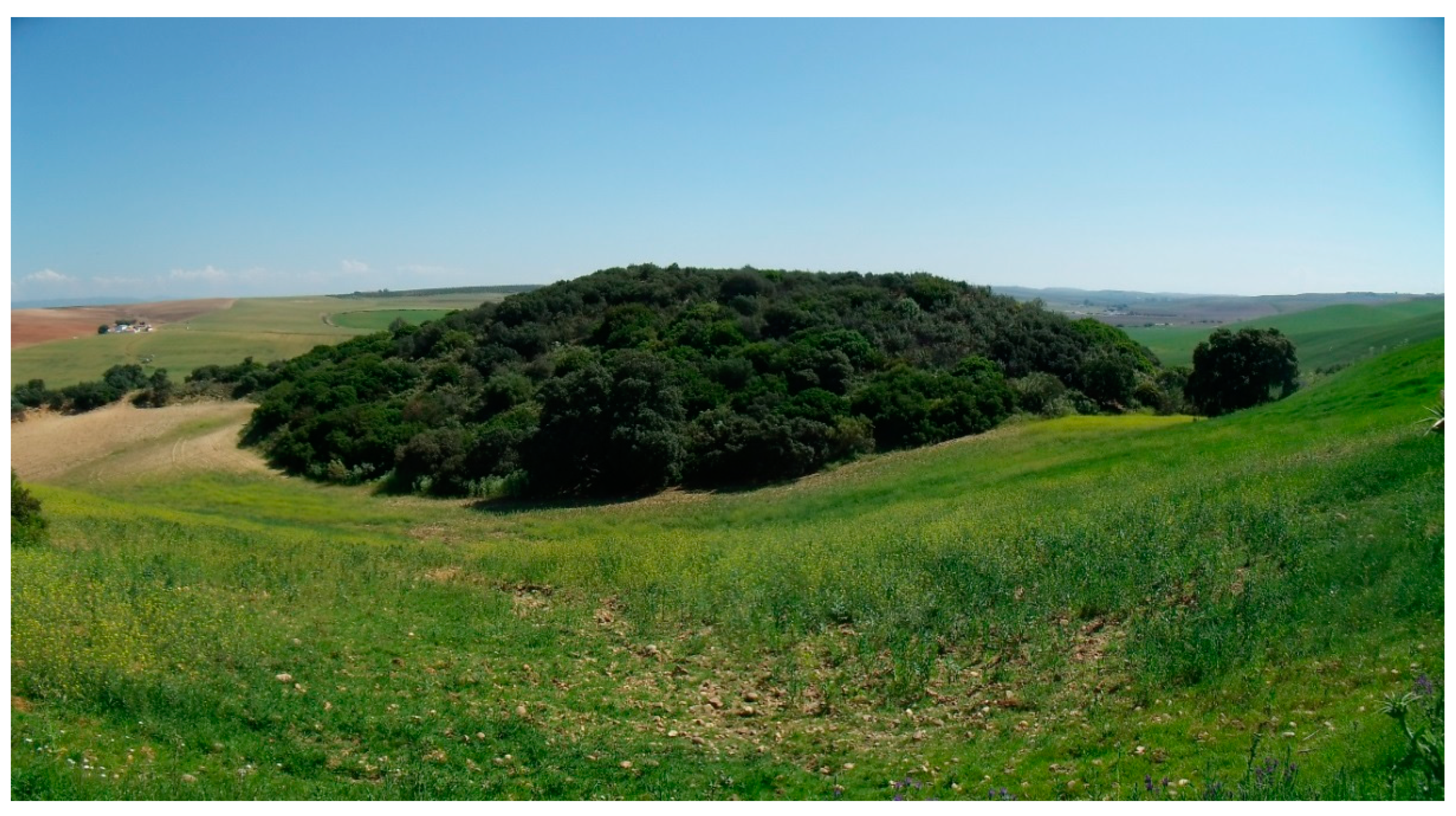
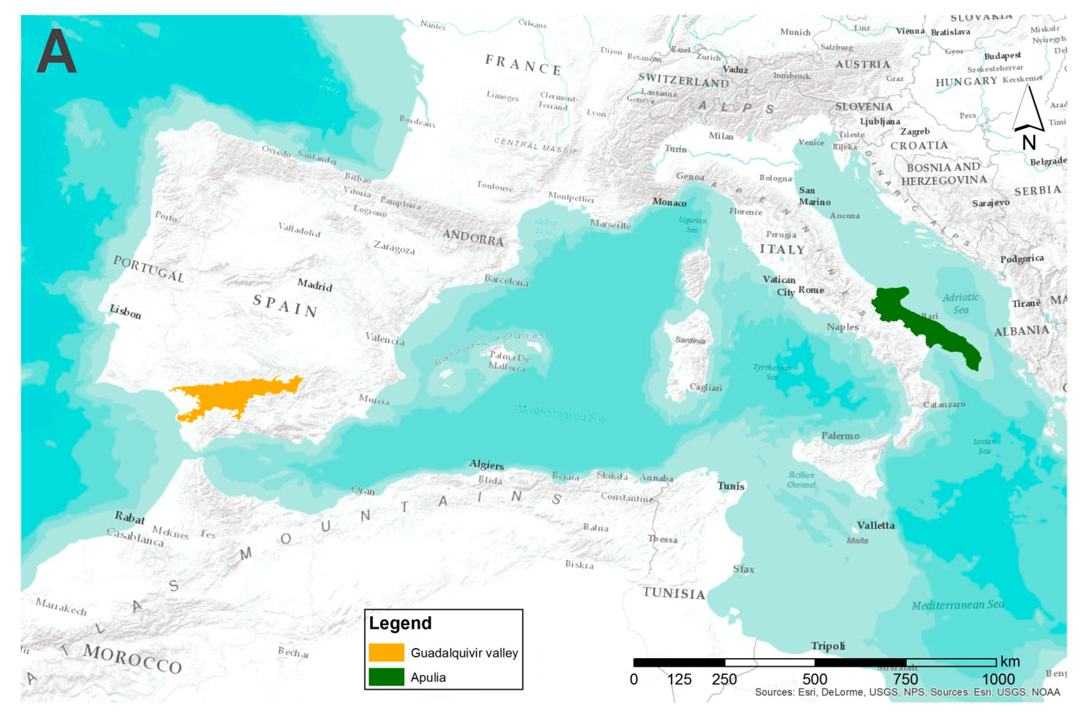
2.1. Study Area

To demonstrate the capacity of this methodology, the study is conducted with the first step in the Guadalquivir Valley (southern Spain, Figure 2A), where a retrospective analysis was carried out. In the second step, the results were compared with an equivalent area in south central Europe: the Apulia region in the south of Italy (Figure 2A). Both areas are widely described as representative of Mediterranean oak forests, with a high degree of deforestation due to conversion into arable land (Figure 2B,C).
The study areas are both located in the Mediterranean region [27]. The Mediterranean landscape is rich in biodiversity due to its physiographic and climatic diversity, historical dynamics and the coexistence of semi-natural spaces developed for traditional agricultural and livestock purposes together with areas of natural vegetation [28,29,30]. This is considered an endangered hotspot of biodiversity [31] by the International Union of Conservation of Nature [32,33]. It is an extremely fragile area, vulnerable to Global Change where oak forest decline is leading to pyrophytic shrublands [34]. Fires are natural disturbances in Mediterranean ecosystems and have contributed to landscape dynamics for thousands of years [35]. However, the Mediterranean Basin is projected to suffer a generalized rise in mean temperatures, and rainfall to undergo irregular patterns [36]. These climatic anomalies [37] have imperilled the current outlook for this fragile ecosystem the worst.

2.2. Reference Cartography

The Spanish study area corresponds to the Guadalquivir valley (Hispalenseac biogeographic sector, Baetic Province, Mediterranean Region). This area pertains to the Guadalquivir basin, a depression filled with the sediments of the surrounding mountain ranges. The valley covers an area of about 17,188 km2, or 20% of the area of Andalusia. It is a Mediterranean ecosystem, the main tree species being the holm oak (Quercus ilex L. subsp. Ballota (Desf.) Samp) and, to a lesser extent, the cork oak (Q. suber L.) [15]. The reference cartography for current IFs of the Quercus species in the Guadalquivir valley is based on the map developed by Hidalgo et al. [38] This map was derived from several cartographic sources: the MUCVA of 2007 (Mapa de Usos y Coberturas Vegetales de Andalucía, 1:25,000 scale, REDIAM, 2018 [39]), SIOSE Andalusia Cartography at a scale of 1:10,000, updated in 2009, and the Forest Map of Andalusia, at a scale of 1:50,000, from the 3rd National Forest Inventory 1997–2007. This composite map was validated by an intensive field study in which a total of 685 polygons were visited to confirm the accuracy of the obtained cartographic information previously obtained. The polygons were also reviewed with the most recent orthoimages (PNOA, 2018, WMS server [40]). For a retrospective analysis, a digital map (Map of Usage and Vegetation Cover at a scale of 1:33,000, 1956–1957, REDIAM, 2018, [39]) derived from aerial photographs obtained taken in 1956 was used. For validation, all current polygons in our cartography were reviewed and compared with the digital map of 1956.
The Italian zone corresponds to the Apulia administrative Region (Adriatic Province, Mediterranean Region). The study area covers around 19,345 km2, slightly larger than the Guadalquivir area. It is known as La Terra delle Querce [41], as there is a great diversity of Quercus species: Q. ilex, Q. suber, Q. cerris L., Q. frainetto Ten., Q. pubescens Willd. and Q. trojana Webb. However, the National Forest Inventory identifies its forest index as the lowest in the country, with a worrying lack of green areas, especially in the southern part of the region [42]. The digital cartography of these species was derived from several sources [43]: Carta della Natura in Apulia, using CORINE codes at a scale of 1:50,000, developed by ISPRA (Instituto Superiore per la Protezione e la Ricerca Ambientale), and ARPA Apulia (Agenzia Regionale per la Prevenzione e la Protezione dell’Ambiente della Apulia). The most recent cartography was carried out in 2014 [43]. The composite cartography was validated with the most up-to-date orthoimages available in the WMS server http://webapps.sit.puglia.it (last accessed on 15 November 2017). Unfortunately, no historical cartography was available from the Apulia region for retrospective analysis.
In both areas, a 1 km buffer was applied to the forested areas using Geographic Information Systems (ArcGis 10.1, ©ESRI) in order to ensure that these could be considered as isolated. Hence, any IF located in a clear forest domain was filtered out and removed from the digital cartography. By contrast, all IFs surrounded by agricultural matrix remained in the study, as they were clearly identifiable in the landscape. Following the definition of an Island Forest [44], only the polygons with a size between 1 to 1000 hectares and tree cover greater than 50% were selected. In this way, only IFs of sufficient habitat quality were considered. The final result was a digital map of polygons made up of polygons containing Quercus species that play an analogous ecological role in the two regions/time slice. In the Italian region, the study excludes short-term plantations of Quercus for biomass production in order to focus exclusively on natural forest sites.

2.3. Fragmentation and Connectivity Analysis

The fragmentation and connectivity study was conducted with the Conefor 2.6 tool (http://www.conefor.org, last accessed on 15 November 2017). There are many other tools for fragmentation, connectivity studies and ecological corridors design (see https://conservationcorridor.org/corridor-toolbox/programs-and-tools/ for further details, last accessed on 15 August 2021). However, Conefor has been demonstrated to be the most powerful tool for quantifying the importance of habitat areas, i.e., the main goal of our study. This software is free and relatively easy to manage. However, an intensive training course should be carried out to obtain optimum results. This software is based on graph structures [45,46,47], whereby, in our study, IFs were nodes and the distance between them connectors. Conefor calculates the PC index (Probability of Connection index), which is the probability that two points randomly located in the landscape are connected in a set composed of n patches and their connections [48,49]. The index provides a single value for the entire landscape, and also measures the amount of available habitat in the landscape. This unique value for a given area is useful for comparing different areas or for retrospective analysis. The PC is given by the formula:
PC = i = 1 n · j = 1 n a i · a j · p i j A L 2
where, for i to j patches:
  • n is the total number of patches or nodes in the landscape,
  • a are the attributes of the patches (area in our study),
  • Pij is the product of the maximum probability, i.e., the probability of direct and indirect dispersion between patches i to j,
  • AL is the maximum landscape attribute, i.e., summation of the attributes of all the patches in the landscape (total area in our study).
The value of pij is given by the formula:
pij = e (−dij/α)
where, for i to j patches:
  • dij is the distance between nodes i to j,
  • α is the dispersion distance of the species,
The threshold of patch connectivity distance is necessary for the calculation of the PC [50]. In our study, the PC value was calculated for all region/time slices using a maximum dispersion distance established as α = 500 m, taking the following rodents and birds as the main dispersal vectors of acorns (the fruit of Quercus trees): the wood mouse (Apodemus sylvaticus) and the Eurasian jay (Garrulus glandarius) [51,52,53,54,55,56,57]. Due to their nutritional value, acorns are attractive to most of the frugivorous fauna [58]. A minimal part of hidden acorns is not consumed, and they germinate under favourable conditions [54,59,60]. The Eurasian jay plays an important role in the colonization of Quercus species. It is responsible for the dispersal of acorns over thousands of meters during the ripening season [53,61] and is the key factor in the regeneration of holm oak forests [55]. However, this bird is very sensitive to landscape fragmentation, tending to disappear in small–medium fragments [62]. Therefore, in highly fragmented areas, the regeneration of oak forests depends almost exclusively on the activity of rodents [63], the field mouse (Apodemus sylvaticus, L.) being the main dispersal species in both study areas. It is able to survive in adjacent areas (ecotone) subjected to different management [52,64]. A study on the dispersal and predation of acorns shows that 70% of all fruits collected after the first dispersive movement were dispersed again by rodents at distances exceeding 130 m [65]. These distances also depend on the slope, with downhill displacement increasing hundreds of meters, and uphill displacement rarely reaching 50 m. In conclusion, an average of α = 500 m seems to be a reasonable dispersion distance when the probability was set to 0.5 [50], i.e., at least 50% of the acorns are able to reach the distance of α = 500 m.
Conefor also estimates the individual contribution of each patch to the connectivity by means of probabilistic models. This contribution is the dPC (differential of Probability of Connection) index, which is the percentage of variation in the PC index due to the elimination of each patch in the landscape. It summarizes the role of each path in the connectivity of the studied area. The dPC is given by the formula:
dPC k = PC PC e l i m PC k · 100
The value of dPC can be divided into three different parameters (Figure 3) [49]:
dPCK= dPCintra + dPCflux + dPCconnector
where:
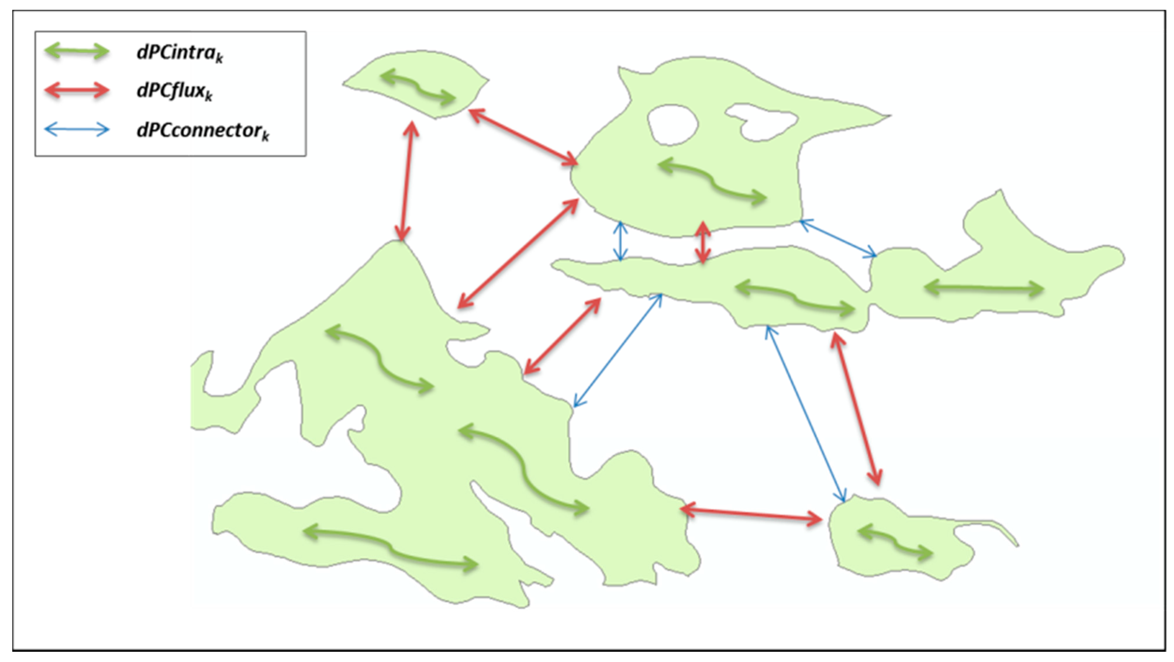
  • dPCintra or intrapatch: This refers to connections between the resources available within the same patch, i.e., the internal connectivity of each patch. When the attribute used is its area, this factor depends on the patch size, which means that the larger the size, the greater the dPCintra, regardless of the space it occupies in the set of patches. A patch with a high dPCintra value could be considered as a core habitat.
  • dPCflux or interpach: This represents the direct dispersion flow to the other patches, that is, the flow that occurs between two patches without the need for a third to act as a bridge.
  • dPCconnector or stepping stone: This measures how a patch facilitates dispersion without being the origin or destination of the connection. It is the contribution of each patch as a connecting element or bridge to the other patches of the study area. These elements are known as stepping stones in landscape ecology [66]. Stepping stones are patches of habitat that are smaller than the core habitat patches. The value of dPCconnector fluctuates in relation to the position it occupies with respect to the rest of the patches.
Although individual dPC values are of interest in the management of each polygon within the landscape and in the creation of ecological corridors, in our analysis we will show only the sum and mean dPC in order to provide a quick overview of the fragmentation status of each territory/time slice. Only for particular examples will we show the dPC value for each polygon. In order to facilitate the interpretation of the role of each IF in the landscape, the dPC values have been categorized into 5 intervals (Table 1) using a red-to-green colour scale, in which dark green identifies the most significant IFs in terms of connectivity, and red the most isolated. A qualitative value of connectivity is assigned to each interval using the scale of low, medium low, medium, medium high, and high. Patches with dPC > 10 were considered as important core areas and sources of species. Patches with dPC < 10 can be considered as stepping stones with a role in connectivity depending on the value assigned in the scale.

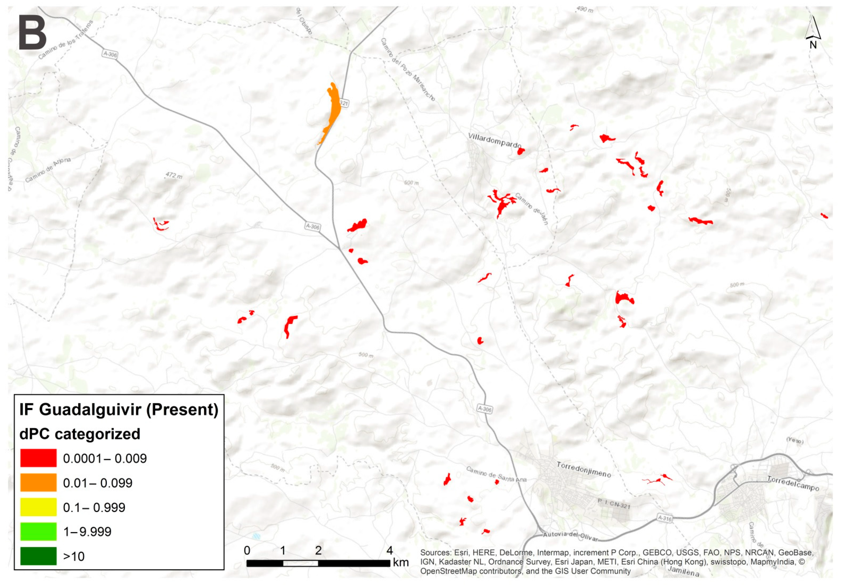
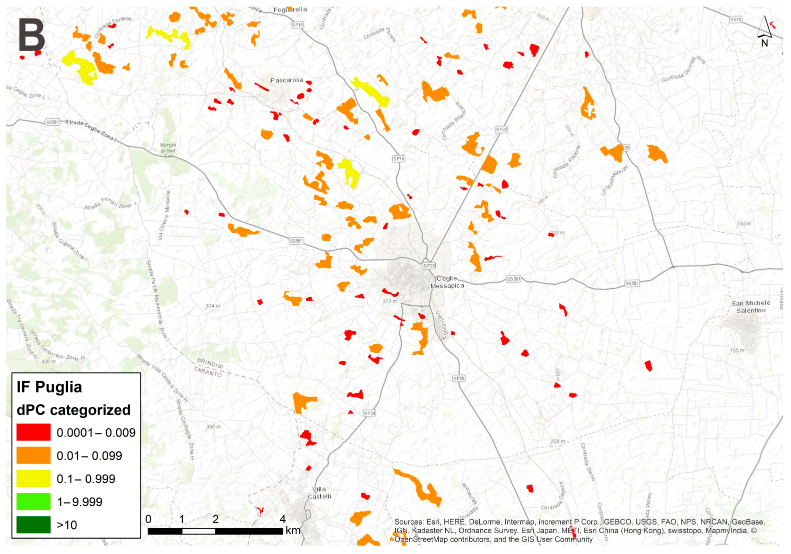
3. Results and Discussion

Island forests were widely distributed in 1956 along the valley, although concentrated in certain specific areas (Figure 4). However, in the present (Figure 5), the number of IFs is clearly lower. Many areas where the forests were well represented have disappeared. Table 2 shows the IF data for Quercus trees in both time slices. Of the 975 IFs in 1956, only 706 remain, a total of 206 IF loss in around six decades. This is not the only loss in this process. The total area of IFs in 1956 was 27,832.82 ha, representing 1.62% of the total surface, of which only 11,622.49 ha remains nowadays, a reduction of a 58.24% and with a representation of only 0.62% of the territory. A comparable dramatic reduction over a short period of time has also been reported in Brazilian Cerrado (tropical savannah) where 23.9% of natural patches have been lost in 17 years [16]. In addition, the mean area of the Guadalquivir valley IFs nowadays has shrunk from 28.55 ha to 16.04 ha. This means that those IFs that do remain are now approximately half the size of the originals. Notably, the mean perimeter of IFs has remained pretty much the same since 1956, despite the total number of patch perimeters being higher than today. In short, there is less area but the same perimeter, i.e., one of the main factors contributing to an increase in the edge effect.
With respect to the distribution of IF of Quercus in the Apulia region (Figure 6), the surviving IFs in this agricultural area are concentrated in the north, linked to other natural forests of the Meridional (southern) Apennines as a result of a transition landscape. In the south, they spread out to the southeast of Bari in areas which are hard to convert into arable land and therefore permit natural forests to remain. The rest of the IFs are scattered across in the huge territory in a sporadic fashion. Comparing these results with those obtained for the Guadalquivir valley in the present (Table 2), it is notable that there are 340 more polygons in the Apulia region. The total area in Apulia is higher, but the mean area of IFs is lower, i.e., there are more polygons, but they are smaller. This result is coherent with areas subjected to intensive agriculture, a process leading to a drastic erosion of the original natural ecosystem into remnant forests. With respect to the mean perimeter, this is of the same magnitude as the Guadalquivir valley in both periods.
Concerning the results of the fragmentation analysis obtained by the Conefor software (Table 3), PC values indicate the present situation with respect to connectivity for each territory/time slice. The best result (4670.62) was obtained in the Guadalquivir valley in 1956. This value of PC has declined to 1987.64 (57.44%) in approximately 6 decades. It means that the probability of connection of two isolated patches in the landscape has been reduced by more than a half. This retrospective analysis has proved to be a useful tool for quantifying the functional connectivity changes in the landscape of this region. The applied methodology allows us to understand the recent changes in a given area using quantitative data. Similar results have been obtained in other retrospective studies conducted in other parts of the world [67] where global connectivity (PC value) has progressively decreased over recent decades.
Comparing the results of present status in the Guadalquivir and the Apulia regions, the PC values for both are similar, albeit slightly higher in Apulia, possibly due to the higher number of polygons. It is interesting to point out that there are many areas in Apulia without any Ifs, but the presence of more polygons across the region makes it as connected as the Guadalquivir valley, where the polygons are more evenly distributed. As this study demonstrates, although PC values are intrinsic to a given territory, comparative analyses can be particularly useful, in terms of both in different territories and in time.
With respect to dPC values, i.e., the contribution of each polygon to the connectivity, the total for the Apulia region is similar to that of the historical situation in the Guadalquivir valley, while the present Guadalquivir situation is slightly lower. This indicates that there are fewer polygons in the Guadalquivir valley nowadays with a lower degree of connectivity and explains the lower PC values in this region. However, the mean value in this area is higher than in the other region/time slices, possibly due to the higher contribution of the surviving IF polygons. Differentiating between the component of dPC (dPCinta, dPCflux and dPCconnect), the values for dPCintra are higher in the present Guadalquivir. It means that internal connectivity is more important than the other parameters. By contrast, the values of dPCflux and dPCconnect are lower, which account for the low value of the overall dPC. This is to say, when the role that an IF plays in connectivity is low, only internal connectivity gains importance. This explains the lower values for dPCflux and dPCconnect in this area in comparison to the other region/time slices.
Detailed analysis of the contribution of each IF to the connectivity in the selected areas/time slices was carried out in various representative areas, where we used the standardization of the values for dPC described in the materials and method section. The value of dPC, unique for each element in the territory, has proved to be a powerful tool for connectivity analysis [68,69].
The first analysis compared the IFs in a selected area of the Guadalquivir valley in 1956 and the present day (Figure 7). Figure 7A shows the area located to the southwest of the city of Córdoba (Spain). The occurrence of IFs is abundant and the value of dPC of the main patches corresponds to the highest connectivity interval. In at least one patch (the largest, in the southeast, and rounded in shape) there is a good well-defined core habitat. In the second image (Figure 7B), the situation in the present time is radically different. Only a few patches remain and only one has the maximum value for connectivity as described in Table 1. The large patch with an excellent core habitat in 1956 has been reduced to several isolated patches where the values of dPC have been reduced to medium–low values of connectivity. The cause of this degradation of the original IFs is the intensive transformation of land use in this fertile agricultural area. Although the creation of ecological corridors could improve the connectivity of this over-occupied landscape, the possibilities are now more limited than in 1956; success is far from guaranteed, and the cost effectiveness of the implementation of such a project could well be minimal. Further, landscape connectivity is lost when the threshold dispersion distance (α = 500 m) is surpassed, or the remaining IFs fall (low dPCintra) below a threshold [16]. Unfortunately, many missing areas detected in 1956 are now impossible to recover because they are highly profitable arable land and reversion is only possible through means beyond our control. Only abandoned arable land provides opportunities for passive rewilding [57] or ecological restoration.
Further comparison between historical (Figure 8A) and present day (Figure 8B) in an area of the Guadalquivir valley shows that the situation has improved. A set of isolated patches with low values of dPC are now better connected. New IFs have arisen due to the introduction of Quercus trees (holm oak) for livestock purposes or on abandoned farmland. Although the area needs proper management to promote the connectivity, the improvement in dPC values of the present IFs guarantees the success of the promotion of ecological corridors. These areas provide opportunities for passive rewilding of areas where habitat removal has ceased, as demonstrated for Quercus robur L. in England [57].
Two representative areas of the Guadalquivir valley today are compared in Figure 9. The first (Figure 9A) to the east of the village of Arahal (province of Seville, Spain) shows a well-defined core habitat with a scant edge effect and with a significant role in the connectivity (high dPC value). These well-preserved areas are important sources of seed (acorns in our study) and other plants or animals to be dispersed to adjacent IFs. In this case, an interesting synergic consequence could result: the greater the dispersion of the vector species (wood mouse in our case), the greater the dispersion of acorns and ultimately of the forests [58,64]. The second image (Figure 9B) is an area close to Villadonpardo (province of Jaen, Spain) with dispersed IFs playing a minimal role in the total connectivity (low dPC value). The presence of dispersed IFs with low dPC values indicates that the possibility of connection is limited, and the area requires a specific management to promote the dispersion of the species.
Similar results are shown in Figure 10 for the Apulia region. The first image (Figure 10A), corresponding to the area of Volturino (Foggia, Italy), shows a well-defined core habitat patch (dPC > 1) where the maintenance of the biodiversity is guaranteed. Surrounding this core are many other polygons of interest in the creation of ecological corridors in the form of stepping stones (dPC < 1) to promote connectivity. By contrast, the second image (Figure 10B), located in Ceglie Messapica (Brindisi, Italy), shows a highly fragmented area where the role of IFs plays a less significant role in terms of connectivity. The presence of numerous IFs with medium–medium-low dPC values makes this area of interest for ecological restoration as they play an important part in acting as stepping stones [66,70] to connect other core habitats or the surrounding protected sites.
In summary, the new methodology applied has proven to be a powerful tool for analyzing the status of fragmentation in a given area. The abundant available digital cartography in combination with specific software (GIS and Conefor) work well in tandem to tackle the tangled problem of habitat fragmentation [71]. Although the digital cartography used in this study entails a lot of effort to obtain high-quality data, the methodology is feasible and easily improved by using the most recent techniques in GIS and automatic teledetection.
One of the main problems when managing the landscape is the scarcity of objective criteria for the selection of suitable areas to create corridors or to invest in ecological restoration. These activities are easily carried out in natural or semi-natural protected sites, where the management falls on the corresponding administration. In the case of highly anthropogenically modified landscapes, as described in this study, the survival of IFs is not guaranteed, and the promotion of connectivity is more limited. This is the reason why a classification system of the remnant habitat patches (Island Forests in this study) is absolutely essential before the establishment of ecological corridors or activities of ecological restoration [69]. The new methodology proposed in this study is based on quantitative and objective criteria to obtain this classification system before landscape management.
Although habitat fragmentation, along with its consequences, is a well-known phenomenon [8], there is a lack of information on highly fragmented habitats where IFs are scarce. However, the role of these disperse elements in the landscape has been gaining importance in recent times due to their function as a base for ecological corridors in modern conservation biology. This is one of the main objectives of the Natura 2000 network [26], the creation of a coherent protection network in the European Union. In this context, the highly anthropized areas are often the only possibility for connecting different elements of this network (Special Areas of Conservation) that are usually dispersed and unconnected within the territory of the member states.
Our results in the Guadalquivir valley demonstrate that this area has been more strongly anthropized in recent decades, with land use change being the main reason for the loss of IFs [72]. These results demonstrate the considerable increase in the fragmentation of the remnant IFs in the valley, an increase in the edge effect, and a limited connectivity between the remaining patches. This change in land use toward arable land has been common in Western Europe since the mechanization of agriculture, and also frequent in many other areas of the world. However, land use change and fragmentation have not been generalized throughout this territory as many areas unsuitable for agriculture have shown a clear recovery in recent times [9,10]. The reason is well known: those areas with clear agricultural or livestock potential have been subjected to intense pressure, whereas areas with less potential to support fertile crops have been abandoned and ecological succession has enhanced these areas in terms of biodiversity. These areas join the remnants of original habitat (IFs), and along with fences, hedges, and other boundaries entail new opportunities for species dispersion. The permeability of the matrix could be easily improved with a proper management of these dispersed elements as they are the only possibility for promoting the connectivity of the landscape structure [73]. Further studies for the implementation of habitat or landscape corridors are needed after the assessment of stepping stones and core habitats identified in this study.
The applied methodology in our study has been applied to many other species where the dispersion capacity of the species is well known, especially in animals [74]. In the case of habitats/ecosystem, it is necessary to establish several dispersion distances to reflect the different distances of various taxa. In these cases, the analysis is carried out with several estimated dispersion distances [67]. It is also possible to test several distances in order to select the most suitable distance for the whole habitat [75]. However, the implementation of an analysis with a different set of distances makes the results difficult to apply and possibly unsuitable for managers. In our case, a single genus (Quercus) with the same dispersion strategy (zoochory) and similar life form (mesophanerophytes, [76]) is proposed as the main species for the analysis. Fortunately, the main climatic trees of the Mediterranean basin are oaks. Some of them are evergreen, other marcescent, but they occupy the same ecological niche in each territory/ecosystem. As they are the main element of the Mediterranean forest vegetation, our study could be representative of the whole habitat using a single dispersion distance. An alternative method is to reduce this distance to encompass the species with moderate dispersion abilities. This conservative point of view has also been successfully applied for Quercus [48] in an attempt to assess how the montado availability/reachability varies for species with different moving abilities, considering a final distance of α = 200 m instead α = 500 as in our study. In other cases, the maximum dispersion threshold is calculated using a distance based on the average for multiple species susceptible to fragmentation [16]. In any case, we can conclude that our methodology is easily applicable to other regions/areas with forest species different than oaks (Quercus). In these cases, dispersion distances should be adapted to other forest species. With respect to shrublands, it is also possible to develop a fragmentation status analysis as demonstrated for environmentally certified forests exploitation [75].
The results of the comparison between the Guadalquivir valley and the Apulia region demonstrate that the proposed methodology is suitable for international studies. This fact is essential for the management of protected border sites that need common strategies for the interconnection of habitats and species. Connectivity programs usually fail when some elements of the landscape transcend the borders between countries, as strategies are developed independently under the domain of the respective administration in each separate territory. A common methodology, using the same compatible cartography, is more coherent and applicable, and hence more likely to mitigate the effect of habitat fragmentation.

4. Conclusions

Habitat loss and fragmentation is still one of the main threats to biodiversity, and species displacement capacities should be enhanced to meet the challenges of the projected Global Change. This is particularly evident in developing countries, where the use of heavy machinery has intensively transformed many natural areas into fertile arable land during the 20th century. As demonstrated in this study, the result is a highly fragmented landscape with residual dispersed elements in the territory, with a limited capacity to implement ecological corridors. This transformation is especially dramatic in extremely vulnerable areas such as the Mediterranean basin where the adaptation (migration) of species could be more difficult. Strategies directed toward the promotion of species migration are needed, and common methodologies should be developed to mitigate the impacts of global change on biodiversity. Our study highlights the value of Island Forests to develop assessment strategies using homogenized available digital cartography and common criteria for the dispersion distances in graph theory analysis. The application of this new methodology could help in the management of protected sites, such as the Natura 2000 Network, using highly fragmented areas to allow species movement through inhospitable landscapes in a unique opportunity to connect the different protected elements of the Network.

Author Contributions

Conceptualization, P.J.H.; methodology, H.H.; software, A.J.S.-A.; validation, P.J.H., H.H., A.J.S.-A.; formal analysis, P.J.H.; investigation, J.L.-T., F.V.; resources, R.P.; writing—original draft preparation, P.J.H., H.H.; writing—review and editing, P.J.H.; supervision, P.J.H.; project administration, P.J.H., R.P.; funding acquisition, P.J.H., R.P. All authors have read and agreed to the published version of the manuscript.

Funding

This research was funded by the Council of Economy, Innovation, Science and Employment of the Andalusian Government in the framework of the Project ‘‘Modelo espacial de distribución de las quercíneas y otras formaciones forestales de Andalucía: una herramienta para la gestión y la conservación del patrimonio natural’’ (Code P10-RNM-6013) and by FEDER, Junta de Andalucía—Consejería de Economía y Conocimiento. Proyecto UHU-1262837.

Conflicts of Interest

The authors declare no conflict of interest.

References

  1. Fahrig, L. Effects of habitat fragmentation on biodiversity. Annu. Rev. Ecol. Syst. 2003, 34, 487–515. [Google Scholar] [CrossRef] [Green Version]
  2. Crooks, K.R.; Sanjayan, M.A. Connectivity Conservation: Maintaining Connections for Nature. In Connectivity Conservation; Crooks, K.R., Sanjayan, M., Eds.; Cambridge University Press: Cambridge, UK, 2006; pp. 1–20. [Google Scholar]
  3. Butchart, S.H.M.; Walpole, M.; Collen, B.; van Strien, A.; Scharlemann, J.P.W.; Almond, R.E.A.; Baillie, J.E.M.; Bomhard, B.; Brown, C.; Bruno, J.; et al. Global Biodiversity: Indicators of Recent Declines. Science 2010, 328, 1164–1168. [Google Scholar] [CrossRef]
  4. Rands, M.R.W.; Adams, W.M.; Bennun, L.; Butchart, S.H.M.; Clements, A.; Coomes, D.; Entwistle, A.; Hodge, I.; Kapos, V.; Scharlemann, J.P.W.; et al. Biodiversity Conservation: Challenges Beyond 2010. Science 2010, 239, 1298–1303. [Google Scholar] [CrossRef] [PubMed] [Green Version]
  5. Crutzen, P.J.; Stoermer, E.F. The ‘Anthropocene’. Glob. Chang. Newsl. 2000, 41, 17–18. [Google Scholar]
  6. Forman, R.T. Land Mosaics, The Ecology of Landscapes and Regions; Cambridge University Press: Cambridge, UK, 1995. [Google Scholar]
  7. Jongman, R.H.G. Homogenisation and fragmentation of the European landscape: Ecological consequences and solutions. Landsc. Urban Plan 2002, 58, 211–221. [Google Scholar] [CrossRef]
  8. Didham, R.K. Ecological Consequences of Habitat Fragmentation. In Encyclopedia of Life Sciences; John Wiley & Sons, Ltd.: Chichester, UK, 2010. [Google Scholar] [CrossRef]
  9. Fuchs, R.; Herold, M.; Verburg, P.H.; Clevers, J.G.P.W. A high-resolution and harmonized model approach for reconstructing and analysing historic land changes in Europe. Biogeosciences 2013, 10, 1543–1559. [Google Scholar] [CrossRef] [Green Version]
  10. Fuchs, R.; Herold, M.; Verburg, P.H.; Clevers, J.G.P.W.; Eberle, J. Gross changes in reconstructions of historic land cover/use for Europe between 1900–2010. Glob. Chang. Biol. 2015, 21, 299–313. [Google Scholar] [CrossRef] [PubMed]
  11. Saunders, D.A.; Hobbs, R.J.; Margules, C.R. Biological consequences of ecosystem fragmentation: A review. Conserv. Biol. 1991, 5, 18–32. [Google Scholar] [CrossRef]
  12. Andrén, H. Effects of habitat fragmentation on birds and mammals in landscapes with different proportions of suitable habitat: A review. Oikos 1994, 71, 355–366. [Google Scholar] [CrossRef] [Green Version]
  13. MacArthur, R.H.; Wilson, E.O. The Theory of Island Biogeography; Princeton University Press: Princeton, NJ, USA, 1967. [Google Scholar]
  14. Diamond, J.M. The island dilemma: Lessons of modern biogeographical studies for the design of natural reserves. Biol. Conserv. 1975, 7, 129–146. [Google Scholar] [CrossRef]
  15. Blanco, E.; Casado, M.A.; Costa, M.; Escribano, R.; García, M.; Génova, M.; Gómez, A.; Gómez, F.; Moreno, J.C.; Morla, C.; et al. Los Bosques Ibéricos; Editorial Planeta: Barcelona, Spain, 1997. [Google Scholar]
  16. Grande, T.O.; Aguiar, L.M.S.; Machado, R.B. Heating a biodiversity hotspot: Connectivity is more important than remaining habitat. Landsc. Ecol. 2020, 35, 639–657. [Google Scholar] [CrossRef]
  17. Pino, J.; Rodà, J.; Ribas, J.; Pons, X. Landscape structure and bird species richness: Implications for conservation in rural areas between natural parks. Landsc. Urban Plan. 2000, 49, 35–48. [Google Scholar] [CrossRef]
  18. Atauri, J.A.; de Lucio, J.V. The role of landscape structure in species richness distribution of birds, amphibians, reptiles and lepidopterans in Mediterranean landscapes. Landsc. Ecol. 2001, 16, 147–159. [Google Scholar] [CrossRef]
  19. Kemp, J.C.; Barret, G.W. Spatial patterning: Impact of uncultivated corridors on arthropod populations within soybean agroecosystems. Ecology 1989, 70, 114–128. [Google Scholar] [CrossRef]
  20. Vessella, F.; López-Tirado, J.; Simeone, M.C.; Schirone, B.; Hidalgo, P.J. A tree species range in the face of climate change: Cork oak as a study case for the Mediterranean biome. Eur. J. For. Res. 2017, 136, 555–569. [Google Scholar] [CrossRef]
  21. López-Tirado, J.; Vessella, F.; Stephan, J.; Ayan, S.; Schirone, B.; Hidalgo, P.J. Effect of climate change on potential distribution of Cedrus libani A. Rich in the twenty-first century: An Ecological Niche Modeling assessment. New For. 2021, 52, 363–376. [Google Scholar] [CrossRef]
  22. López-Tirado, J.; Hidalgo, P.J. A high resolution predictive model for relict trees in the Mediterranean-mountain forests (Pinus sylvestris L., P. nigra Arnold and Abies pinsapo Boiss.) from the south of Spain: A reliable management tool for reforestation. For. Ecol. Manag. 2014, 330, 105–114. [Google Scholar] [CrossRef]
  23. Aussenac, G. Ecology and ecophysiology of circum-Mediterranean firs in the context of climate change. Ann. For. Sci. 2002, 59, 823–832. [Google Scholar] [CrossRef]
  24. IUCN/SSC. Guidelines for Reintroductions and Other Conservation Translocations; Version 1.0. Gland; IUCN Species Survival Commission: Gland, Switzerland, 2013; pp. 1–57. [Google Scholar]
  25. Anderson, A.B.; Jenkins, C.N. Applying Nature’s Design Corridors as a Strategy for Biodiversity Conservation; Columbia University Press: New York, NY, USA, 2006. [Google Scholar]
  26. Habitats Directive. Council Directive 92/43/EEC of 21 May 1992 on the Conservation of Natural Habitats and of Wild Fauna and Flora. Off. J. Eur. Union 1992, 206, 7–50. [Google Scholar]
  27. Rivas-Martínez, S.; Penas, A.; Díaz, T.E. Biogeographic Map of Europe. 2004. Available online: www.globalbioclimatics.org (accessed on 15 November 2018).
  28. González, F. Ecología y Paisaje; Blume: Madrid, Spain, 1981. [Google Scholar]
  29. Farina, A. Principles and Methods in Landscape Ecology; Chapman and Hall: London, UK, 1998. [Google Scholar]
  30. Blondel, J.; Aronson, J. Biology and Wildlife of the Mediterranean Region; Oxford University Press: Oxford, UK, 1999. [Google Scholar]
  31. Myers, N.; Mittermeier, R.A.; Mittermeier, C.G.; da Fonseca, G.A.B.; Kent, J. Biodiversity hotspots for conservation priorities. Nature 2000, 403, 853. [Google Scholar] [CrossRef] [PubMed]
  32. Médail, F.; Quézel, P. Hot-spots analysis for conservation of plant biodiversity in the Mediterranean Basin. Ann. Mo. Bot. Gard. 1997, 84, 112–127. [Google Scholar] [CrossRef]
  33. Cuttelod, A.; García, N.; Abdul Malak, D.; Temple, H.; Katariya, V. The Mediterranean: A biodiversity hotspot under threat. In Review of the IUCN Red List of Threatened Species; Vié, J.-C., Hilton-Taylor, C., Stuart, S.N., Eds.; IUCN: Gland, Switzerland, 2008. [Google Scholar]
  34. Acácio, V.; Dias, F.S.; Catry, F.X.; Rocha, M.; Moreira, F. Landscape dynamics in Mediterranean oak forests under global change: Understanding the role of anthropogenic and environmental drivers across forest types. Glob. Chang. Biol. 2017, 23, 1199–1217. [Google Scholar] [CrossRef]
  35. Trabaud, L. Recovery following fire of woody plant communities in Alberes (western Pyrenees, France). Vie Milieu 1993, 43, 43–51. [Google Scholar]
  36. IPCC Climate Change 2014: Synthesis Report; Contribution of Working Groups I, II and III to the Fifth Assessment Report of the Intergovernmental Panel on Climate Change; IPCC: Geneva, Switzerland, 2014.
  37. Adame, J.A.; Lope, L.; Hidalgo, P.J.; Sorribas, M.; Gutiérrez-Álvarez, I.; del Águila, A.; Saiz-López, A.; Yela, M. Study of the exceptional meteorological conditions, trace gases and particulate matter measured during the 2017 forest fire in Doñana Natural Park, Spain. Sci. Total Environ. 2018, 45, 710–720. [Google Scholar] [CrossRef]
  38. Hidalgo, P.J.; Porras, R.; López-Tirado, J.; Sánchez, A. Localización y Caracterización de Bosques Islas en la Campiña del Guadalquivir y Corrección de la Cartografía 1:10.000. Proyecto Motriz de Excelencia (P10-RNM-6013); EXP SE-09-14; Universidad de Huelva: Huelva, Spain, 2013. [Google Scholar]
  39. REDIAM. Red de Información Ambiental de la Junta de Andalucía. 2018. Available online: http://www.juntadeandalucia.es/medioambiente/site/rediam (accessed on 15 November 2018).
  40. PNOA. Plan Nacional de Ortofotografía Aérea (PNOA). Available online: https://pnoa.ign.es/ (accessed on 15 November 2018).
  41. Brunori, A. Bosco, cultura e tradizione in Puglia. Alberie Territ. 2005, 12, 7–11. [Google Scholar]
  42. Campanile, G.; Cocca, C. I boschi della Puglia: Caratteristiche e problematiche. Edizioni For. 2005, 2, 172–177. [Google Scholar] [CrossRef]
  43. Lavarra, P.; Angelini, P.; Augello, R.; Bianco, P.M.; Capogrossi, R.; Gennaio, R.; La Ghezza, V.; Marrese, M. Il Sistema Carta della Natura della Regione Puglia; Serie Rapporti 204/2014; ISPRA: Rome, Italy, 2014. [Google Scholar]
  44. Martín, J.; Fernández, L.; Urios, G. Los Bosques Isla en Andalucía. Consejería de Medio Ambiente y Ordenación del Territorio; Junta de Andalucía: Sevilla, Spain, 2013; p. 192. [Google Scholar]
  45. Harary, F. Graph Theory; Addison-Wesley: Reading, MA, USA, 1969. [Google Scholar]
  46. Ricotta, C.; Stanisci, A.; Avena, G.C.; Blasi, C. Connectivity of landscape mosaics: A graph-theoretical approach. Community Ecol. 2000, 1, 89–94. [Google Scholar] [CrossRef]
  47. Machado, R.; Godinho, S.; Guiomar, N.; Gil, A.; Pirnat, J. Using graph theory to analyse and assess changes in Mediterranean woodland connectivity. Landsc. Ecol. 2020, 35, 1291–1308. [Google Scholar] [CrossRef]
  48. Saura, S.; Pascual-Hortal, L. A new habitat availability index to integrate connectivity in the landscape conservation planning: Comparison with existing indices and application to a case study. Landsc. Urban Plan. 2007, 83, 91–103. [Google Scholar] [CrossRef]
  49. Saura, S.; Rubio, L. A common currency for the different ways in which patches and links can contribute to habitat availability and connectivity in the landscape. Ecography 2010, 33, 523–537. [Google Scholar] [CrossRef]
  50. Saura, S.; Torné, J. Conefor Sensinode 2.2: A software package for quantifying the importance of habitat patches for landscape connectivity. Environ. Modell. Softw. 2009, 24, 135–139. [Google Scholar] [CrossRef]
  51. Bossema, I. Jays and oaks: An eco-ethological study of a symbiosis. Behaviour 1979, 70, 1–117. [Google Scholar] [CrossRef] [Green Version]
  52. Díaz, M.; Alonso, C.L. Wood mouse Apodemus sylvaticus winter food supply: Density, condition, breeding, and parasites. Ecology 2003, 84, 2680–2691. [Google Scholar] [CrossRef]
  53. Gómez, J.M. Spatial patterns in long-distance dispersal of Quercus ilex acorns by jays in a heterogeneous landscape. Ecography 2003, 26, 573–584. [Google Scholar] [CrossRef] [Green Version]
  54. Gómez, J.M.; Puerta-Piñeiro, C.; Schupp, E.W. Effectiveness of rodents as local seed dispersers of Holm oaks. Oecologia 2008, 155, 529–537. [Google Scholar] [CrossRef]
  55. Pons, J.; Pausas, J.G. Modelling jay (Garrulus glandarius) abundance and distribution for oak regeneration assessment in Mediterranean landscapes. For. Ecol. Manag. 2008, 256, 578–584. [Google Scholar] [CrossRef]
  56. Perea, R.; Miguel, A.; Gil, L.; Perea, R.; San Miguel, A.; Gil, A. Interacciones planta-animal en la regeneración de Quercus pyrenaica: Ecología y gestión. Ecosistemas 2014, 23, 18–26. [Google Scholar]
  57. Broughton, R.K.; Bullock, J.M.; George, C.; Hill, R.A.; Hinsley, S.A.; Maziarz, M. Long-term woodland restoration on lowland farmland through passive rewilding. PLoS ONE 2021, 16, e0252466. [Google Scholar] [CrossRef]
  58. Lambert, J.E. Seed Dispersal and Frugivory: Ecology, Evolution and Conservation; CAB International: Wallingford, UK, 2002. [Google Scholar]
  59. Pulido, F.J.; Díaz, M. Regeneration of a Mediterranean oak: A whole-cycle approach. Ecoscience 2005, 12, 92–102. [Google Scholar] [CrossRef]
  60. Perea, R.; San Miguel, A.; Gil, L. Leftovers in seed dispersal: Ecological implications of partial seed consumption for oak regeneration. J. Ecol. 2011, 99, 194–201. [Google Scholar] [CrossRef] [Green Version]
  61. Castro, J.; Puerta-Piñero, C.; Leverkus, A.B.; Moreno-Rueda, G.; Sánchez-Miranda, A. Post-fire salvage logging alters a key plant-animal interaction for forest regeneration. Ecosphere 2012, 3, 1–12. [Google Scholar] [CrossRef]
  62. Santos, T.; Tellería, J.L.; Carbonell, R. Bird conservation in fragmented Mediterranean forests of Spain: Effects of geographical location, habitat and landscape degradation. Biol. Conserv. 2002, 105, 113–125. [Google Scholar] [CrossRef]
  63. Cagnin, M.; Moreno, S.; Aloise, G.; Garofalo, G.; Villafuerte, R.; Gaona, P.; Cristaldi, M. Comparative study of Spanish and Italian terrestrial small mammal coenoses from different biotopes in Mediterranean peninsular tip regions. J. Biogeogr. 1998, 25, 1105–1113. [Google Scholar] [CrossRef]
  64. Fitzgibbon, C.D. Small mammals in farm woodlands: The effects of habitat, isolation and surrounding land-use patterns. J. Appl. Ecol. 1997, 34, 530–539. [Google Scholar] [CrossRef]
  65. Perea, R. Dispersión y predación de semillas por fauna: Implicaciones en la regeneración forestal de bosques templados. Ecosistemas 2012, 21, 224–229. [Google Scholar]
  66. Saura, S.; Bodin, Ö.; Fortin, M.J. Stepping stones are crucial for species’ long-distance dispersal and range expansion through habitat networks. J. Appl. Ecol. 2014, 51, 171–182. [Google Scholar] [CrossRef]
  67. Liu, W.; Hughes, A.C.; Bai, Y.; Li, Z.; Mei, C.; Ma, Y. Using landscape connectivity tools to identify conservation priorities in forested areas and potential restoration priorities in rubber plantation in Xishuangbanna, Southwest China. Landsc. Ecol. 2020, 35, 389–402. [Google Scholar] [CrossRef]
  68. Pascual-Hortal, L.; Saura, S. Integrating landscape connectivity in broad-scale forest planning through a new graph-based habitat availability methodology: Application to capercaillie (Tetrao urogallus) in Catalonia (NE Spain). Eur. J. For. Res. 2008, 127, 23–31. [Google Scholar] [CrossRef]
  69. Wang, S.; Wu, M.; Hu, M.; Fan, C.; Wang, T.; Xia, B. Promoting landscape connectivity of highly urbanized area: An ecological network approach. Ecol. Indic. 2021, 125, 107487. [Google Scholar] [CrossRef]
  70. Uezu, A.; Beyer, D.D.; Metzger, J.P. Can agroforest woodlots work as stepping stones for birds in the Atlantic forest region? Biodivers. Conserv. 2008, 17, 1907–1922. [Google Scholar] [CrossRef]
  71. Fahrig, L. Habitat fragmentation: A long and tangled tale. Glob. Ecol. Biogeogr. 2019, 28, 33–41. [Google Scholar] [CrossRef]
  72. Bermejo, D.; Cáceres, F.; Moreira, J.M. Medio siglo de cambios en la evolución del suelo en Andalucía 1956–2007; Consejería de Medio Ambiente, Junta de Andalucía: Seville, Spain, 2011. [Google Scholar]
  73. Taylor, P.D.; Fahrig, L.; Henein, K.; Merriam, G. Connectivity is a vital element of landscape structure. Oikos 1993, 68, 571–573. [Google Scholar] [CrossRef] [Green Version]
  74. Pascual-Hortal, L.; Saura, S. Comparison and development of new graph-based landscape connectivity indices: Towards the priorization of habitat patches and corridors for conservation. Landsc. Ecol. 2006, 21, 959–967. [Google Scholar] [CrossRef]
  75. Sánchez-Almendro, A.J.; Hidalgo, P.J.; Galán, R.; Carrasco, J.M.; López-Tirado, J. Assessment and Monitoring Protocols to Guarantee the Maintenance of Biodiversity in Certified Forests: A Case Study for FSC (Forest Stewardship Council) Forests in Southwestern Spain. Forests 2018, 9, 705. [Google Scholar] [CrossRef] [Green Version]
  76. Raunkiaer, C. The Life Forms of Plants and Statistical Plant Geography; Oxford University Press: Oxford, UK, 1934. [Google Scholar]
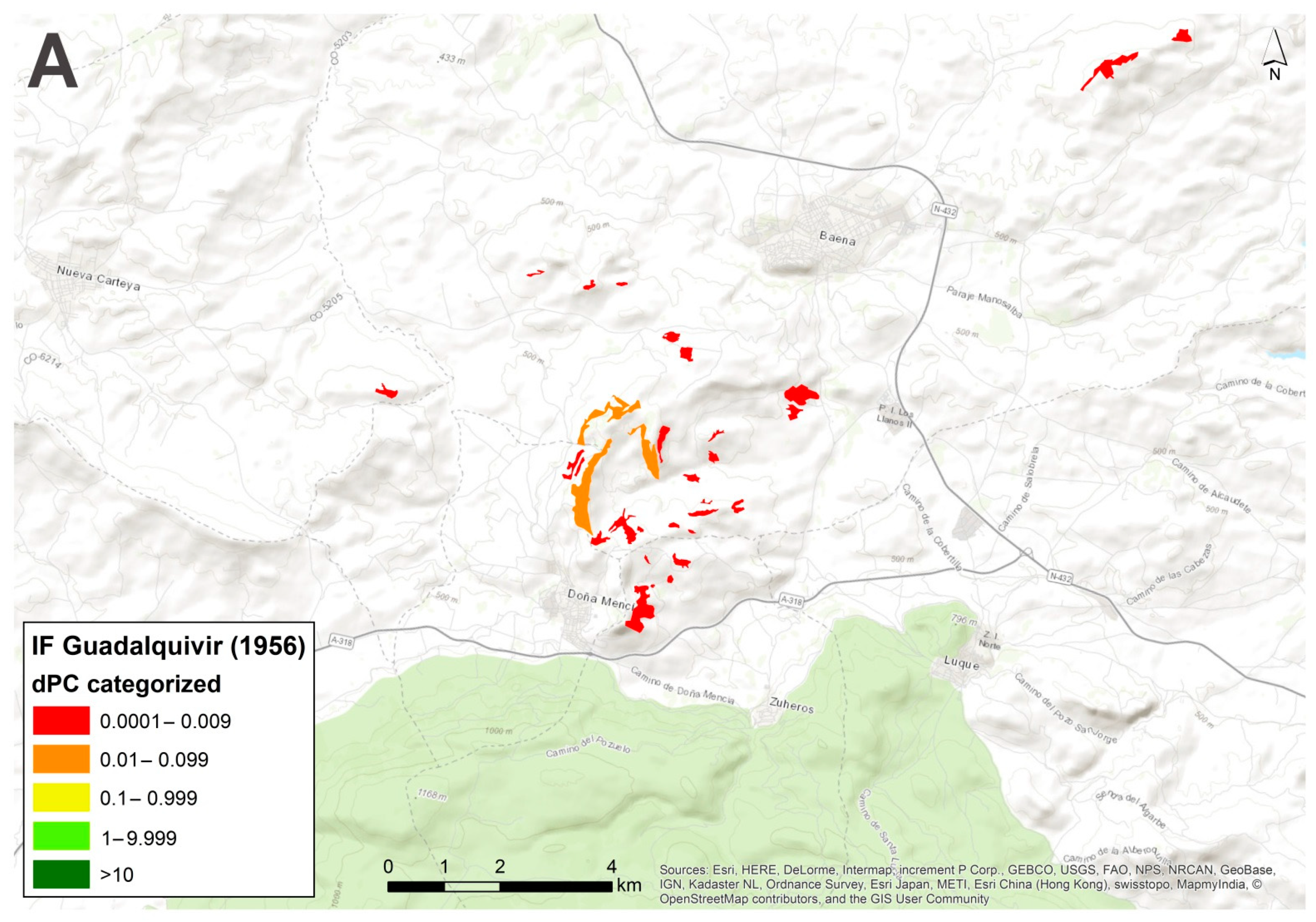
Figure 1. Picture of an Island Forest (IF) in the Guadalquivir valley (Spain) in the middle of a hostile agricultural matrix. The structure of this patch is a forest of holm oak trees accompanied by dense scrubland.
Forests 12 01201 g001
Figure 2. Location of the study area. (A): In orange, the Guadalquivir valley in Spain, in green, the Apulia region in Italy. (B): Detail of the Guadalquivir valley and features of the terrain including Intact Forest Landscape (IFL, ESRI©) in the light green color. (C): Apulia region using the same reference cartography. The absence of nature/native forest in the selected regions is remarkable.
Forests 12 01201 g002aForests 12 01201 g002b
Figure 3. Schematic representation of the three different components of dPC. The value of dPCintra represents the internal connectivity of the patch, dPCflux describes the role of each patch in connecting to surrounding patches (direct connection) and dPCconnetor describes the role of a patch as a stepping stone (intermediate patch).
Forests 12 01201 g003
Figure 4. Distribution of IF in the Guadalquivir valley in 1956.
Forests 12 01201 g004
Figure 5. Present distribution of IFs in the Guadalquivir valley.
Forests 12 01201 g005
Figure 6. Present distribution of IF in the Apulia region.
Forests 12 01201 g006
Figure 7. A comparative analysis of fragmentation status in an area located to the southwest of the city of Córdoba (Spain). (A): IFs in 1956 with high values of dPC. (B): Present situation of IFs. Only a few patches remain, and fragmentation has increased.
Forests 12 01201 g007aForests 12 01201 g007b
Figure 8. A comparative analysis of the fragmentation status in an area located to the southwest of the village of Baena (Córdoba, Spain). In this case, the situation in the present day (B) has improved with respect to 1956 (A).
Forests 12 01201 g008aForests 12 01201 g008b
Figure 9. Two examples in the Guadalquivir valley. The IFs are standardized according to dPC values as described in Table 1. (A) shows a well-defined core habitat with high dPC value to the east of the village of Arahal (Seville, Spain). In (B) is a highly fragmented area in the surroundings of Villadonpardo (Jaen, Spain) with low–medium-low values of dPC.
Forests 12 01201 g009aForests 12 01201 g009b
Figure 10. Two examples in the Apulia region. The first one (A) shows a well-defined core habitat in the area of Volturino (Foggia, Italy). The second (B) is an area in the surroundings of Ceglie Messapica (Brindisi, Italy) with many unconnected fragmentary IFs.
Forests 12 01201 g010aForests 12 01201 g010b
Table 1. Classification of dPC values according to intervals and red-to-green colour scale.
IntervalsdPC ValuesColour ScaleConnectivity
10.0001–0.009 low Forests 12 01201 i001
20.01–0.099 medium low
30.1–0.999 medium
41–9.999 medium high
5>10 high
Table 2. Area, number of polygons, total area of Island Forests (IFs), mean area, perimeter and mean perimeter of the study regions.
Study Area/Time SliceTotal Area (km2)nº PolygonsTotal IF Area (ha)Mean Area (ha)Total Perimeter (m)Mean Perimeter (m)
Guadalquivir 195617,18897527,832.8228.552,681,3352311
Guadalquivir (present)17,18870611,622.4916.041,789,7462535
Apulia (present)19,345104613,327.6413.072,527,2632416
Table 3. Results of the fragmentation analysis. Values for PC (Probability of Connection), dPC and mean, with the three components of dPC (dPCintra, dPCflux, and dPCconnector).
Area/Time SlicePCΣ dPC/Mean dPCΣ dPCintra/Mean dPCintraΣ dPCflux/Mean dPCfluxΣ dPCconnect/Mean dPCconnect
Guadalquivir 19564670.62192.29/0.1940.17/0.04119.65/0.1232.46/0.03
Guadalquivir (present)1987.64176.42/0.2445.84/0.06108.30/0.1521.89/0.03
Apulia (present)2470.88193.12/0.1839.56/0.03120.87/0.1233.49/0.03
Publisher’s Note: MDPI stays neutral with regard to jurisdictional claims in published maps and institutional affiliations.

