Article

Ecological Vulnerability in the Red Soil Erosion Area of Changting under Continuous Ecological Restoration: Spatiotemporal Dynamic Evolution and Prediction

1
College of Forestry, Fujian Agriculture and Forestry University, Fuzhou 350002, China
2
Key Laboratory of the State Forestry and Grassland Administration on Soil and Water Conservation of the Red Soil Region in Southern China, Fuzhou 350002, China
3
Cross-Strait Collaborative Innovation Center of Soil and Water Conservation in the Red Soil Region, Fuzhou 350002, China
*
Author to whom correspondence should be addressed.
Forests 2022, 13(12), 2136; https://doi.org/10.3390/f13122136
Submission received: 15 November 2022 / Revised: 8 December 2022 / Accepted: 8 December 2022 / Published: 13 December 2022
(This article belongs to the Section Forest Ecology and Management)

Abstract

:
Sustainable restoration of degraded ecosystems is a major environmental concern in several regions of China. Changting is one of the severely affected water- and soil-loss areas in southern China that have been under continuous management for the last 30 years. Taking the typical red soil erosion area in Changting, Fujian, as the research object, an evaluation index system with 30 m resolution was developed based on the Sensitivity–Resilience–Pressure (SRP) model. Spatial principal component analysis, Global Moran’s I, the LISA cluster map, and the CA-Markov model were employed to dynamically evaluate and predict the ecological vulnerability of the red soil erosion area in Changting. The findings revealed that the ecological vulnerability of the red soil erosion area in Changting has obvious spatial differences and topography, meteorological, and economic and social variables are the primary driving factors of ecological vulnerability. The analysis of spatial distribution of ecological vulnerability showed significant sets of contiguous locations of severe and mild ecological vulnerability. The total index of ecological vulnerability in the study area reduced by 9.49% from 2000 to 2020, yet it was still just mildly vulnerable. The proportion of severe and extremely vulnerable areas declined by 4.87% and 5.61%, respectively. The prediction results for the coming ten years showed that the ecological vulnerability of red soil erosion in Changting will tend to improve. In summary, it is found that after years of continuous ecological management in the red soil erosion area of Changting, the ecological restoration effect of the soil erosion area is obvious.

1. Introduction

Ecological restoration has become a popular research topic worldwide because of the pressure that economic activities have put on the natural environment [1]. Changting County, Fujian Province, is China’s second-largest water- and soil-loss area after Loess Plateau and is among the most severe soil- and water-loss sites in southern China’s red soil erosion zone. Long-term water and soil loss have caused vegetation destruction, soil fertility decline, ecosystem function degradation, and a fragile ecological environment, which has seriously affected the sustainable growth of regional ecology and economy [2]. In recent decades, water and soil loss in the red soil erosion of Changting has been initially restricted, and the ecological environment has been gradually improved through continuous high-intensity management. “Changting County’s Comprehensive Control of Water and Soil Loss and Ecological Restoration Practice” was selected as a typical ecological restoration case at the 15th Conference of the Parties to the World Convention on Biological Diversity (COP15), which can provide an important reference for degraded ecological restoration [3]. However, its ecological vulnerability distribution patterns and development tendencies remain unknown, posing a challenge to future sustained and accurate management.
Ecological vulnerability is the sensitive response and self-recovery ability of ecosystem to external disturbance in specific time and space scale, which is the inherent attribute of ecosystem [4]. It is integral in guiding regional environmental renovation. Several researchers have recently conducted studies assessing and predicting eco-environmental vulnerability in degraded areas [5,6]. In terms of research scale, ecological vulnerability is mostly evaluated in provincial, municipal, county, or urban agglomerations that share particular characteristics; in terms of ecological vulnerability assessment models, the Pressure–State–Response (PSR) model [7], Vulnerability–Scoping–Diagram (VSD) model [8], and Sensitivity–Resilience–Pressure (SRP) model [9] are among those that have been developed; in terms of ecological vulnerability assessment methods, the fuzzy assessment method [10], analytic hierarchy process [6], spatial principal component analysis [11], and artificial neural network [12] are mainly developed; in terms of ecological vulnerability prediction models, the CENTURY model, CA-Markov model, BIOME model, and grey prediction model are used [13]. However, due to the different characteristics and research purposes of different research areas, there is currently no universal assessment model and method, and most of the current studies focus on small-scale research, which may not be representative for large-scale areas. Therefore, it is crucial to investigate and evaluate assessment models and procedures appropriate for various fields. The SRP model has the advantages of a complete assessment system and a comprehensive index, which can fully reflect the comprehensive characteristics of ecological vulnerability. Aretano et al. [14] investigated the ecological vulnerability of the Apulia National Nature Reserve in southern Italy under fire conditions using the SRP model and GIS. They found that the most vulnerable areas were continuous wetland patches, small patches of forests with a hundred-year history, Mediterranean marques, and coastal dunes. The potential fire risk is the highest in these areas and corresponds to the actual situation. Using the SRP model, Dai et al. [15] combined spatial principal component analysis with the CA-Markov model to assess and forecast Panzhihua City’s ecological vulnerability from 2005 to 2015. They discovered that the ecological vulnerability was decreasing annually, future development is in good condition, and prediction results have also been confirmed. However, the applicability of SRP and CA-Markov models in the distribution patterns, key factors, and development trend of ecological vulnerability in the red soil erosion area of Changting is still unclear.
According to the SRP model, the natural and socioeconomic factors were combined, and 11 assessment indicators, such as elevation, population density, and the kind of land use, were chosen. The spatial principal component analysis and spatial autocorrelation were utilized to dynamically evaluate the ecological vulnerability of the red soil erosion area in Changting every five years from 2000 to 2020. The CA-Markov model was employed to forecast its ecological vulnerability for the coming ten years. It will provide a reference for ecological environment protection and governance and the basis for the future governance direction of the area. It has important research significance in both theoretical and practical aspects.

2. Materials and Methods

2.1. The Study Area

Changting County is situated near the southern foot of Wuyi Mountain in the western portion of Fujian Province (25°18′40″–26°02′05″ N, 116°00′45″–116°39′20″ E) (Figure 1). The landscape is high in the northeast and low in the southwest, with low mountains and hills making up most of the landforms. It has a subtropical oceanic monsoon climate with an average annual temperature of 18 °C, 1700 mm of precipitation, and 260 days without frost. The main parent rock type is acid igneous rock, and red soil is the main type of soil formed after weathering. The forest is broad-leaved subtropical evergreen forest, and the coverage level is generally high, but the forest composition is too singular; the trees are mainly Pinus massoniana, and the understory vegetation species are few, dominated by Dicranopteris dichotoma. Changting County became one of the most typical soil erosion sites in southern China’s hilly red soil region due to the loose structure and weak anti-erodibility of the soil, along with the intentional loss of surface vegetation. In 1985, the area of soil and water loss in Changting County reached 980 km2, accounting for 31.5% of the county area. At the beginning of the 20th century, Changting County’s area of soil and water loss decreased to approximately 47 km2, thanks to actions such as hillside closures and tree planting in soil- and water-loss areas. Since then, Changting County has started implementing mountain, water, soil, and atmospheric system linkage management, which has sparked a new round of soil erosion control [16].

2.2. Data Sources and Preprocessing

2.2.1. Data Sources

The DEM, meteorological, remote sensing, and socioeconomic data were taken every five years from 2000 to 2020. Among them, the DEM data were gathered from the Geospatial Data Cloud (http://www.gscloud.cn/) (accessed on 14 April 2022) GDEMV3 version with a 30 m resolution. The remote sensing data were collected from the Geospatial Data Cloud, with 30 m resolution Landsat 4–5 TM satellite images from 2000 to 2010 and 30 m resolution Landsat8 OLI_TIRS satellite images from 2015 to 2020 (the shooting time was the summer vegetation growth period). The monthly mean precipitation and temperature data were obtained from the National Earth System Science Data Center (http://www.geodata.cn/) (accessed on 15 April 2022) with a resolution of 1000 m. The population density and GDP density data were obtained from the Resource and Environment Science and Data Center (http://www.resdc.cn/) (accessed on 15 April 2022) with a resolution of 1000 m. The soil texture data were obtained from the China Soil Dataset (V1.1) (http://westdc.westgis.ac.cn/) (accessed on 7 May 2022) of Harmonized World Soil Database (HWSD) with a resolution of 1000 m.

2.2.2. Data Preprocessing

The elevation, slope length, topographic relief, yearly average temperature, precipitation, population density, GDP density index, and soil erodibility factor K were extracted from the DEM, socioeconomic, meteorological, and soil texture data using ArcGIS 10.6. The precision of the classification results was evaluated after the remote sensing data were supervised and classified using ENVI 5.3 to obtain the land use indicator. The test results showed that the overall classification accuracy from 2000 to 2020 was 86.00%, 92.59%, 96.30%, 97.30%, and 95.37%, and the Kappa coefficient was 85.35%, 92.05%, 85.55%, 89.11%, and 95.09%. The classification results were imported into Fragstats 4.2 for calculating the landscape diversity index (SHDI). The normalized difference vegetation index (NDVI) was extracted from satellite imagery in ENVI 5.3, and vegetation coverage (FVC) was calculated in ArcGIS 10.6. Due to varying data sources and precisions, all data were unified during processing into the WGS-1984 coordinate system and WGS 1984 UTM Zone 50 N projection, and the resolution was standardized to 30 m.

2.3. Research Methods

2.3.1. Construction of Assessment Index System

In the red soil erosion area of Changting, 11 assessment indexes were selected based on the framework of the SRP assessment model, combined with ecological problems such as water and soil loss, concentrated and intense rainfall, and vegetation destruction, in accordance with the principles of scientificity, systematization, accessibility, and timeliness of data. According to the impact of each assessment index on ecological vulnerability, the indicators were divided into positive, negative, and qualitative indicators (Table 1).

2.3.2. Standardization of Evaluation Index

Because the dimensions of different assessment indicators differed, they were required to be standardized before being evaluated so that the values of all indicators ranged from 0 to 1.
(1) Range standardization [17]:
Standardization of positive indicators:
  A i = H i H m i n H m a x H m i n
Standardization of negative indicators:
  A i = H m a x H i H m a x H m i n
where Ai represents the normalized value of index i, Hi represents the original value of index i, and Hmax and Hmin represent the max and min values of the index.
(2) Standardization of grading assignment: construction land, water area, forest land, grassland, cultivated land, and unused land were assigned as 0, 0, 0.2, 0.3, 0.4, and 1, respectively [10]; slight erosion, mild erosion, moderate erosion, strong erosion, and extremely strong/severe erosion were assigned as 0.2, 0.4, 0.6, 0.8, and 1, respectively [18].

2.3.3. Ecological Vulnerability Assessment Method [19]

Spatial principal component analysis can establish new indicators through linear transformation to reflect the original information as much as possible. These new indicators contain the original information with different weights. When the weight of the original indicators in these new indicators is larger, it shows that these original indicators have a higher contribution rate to the new indicators. After the 11 evaluation indexes were standardized, the spatial principal component analysis method was used to select the principal components with eigenvalues greater than 1 and calculate the weights of each index to produce the ecological vulnerability index for each period in the red soil erosion area of Changting. The following is the calculating formula:
E = i = 1 n x i Y i
where E represents the ecological vulnerability index, xi represents the contribution rate of the ith principal component, and Yi represents the score of the ith principal component.
At the same time, E was standardized, and the calculation formula is as follows:
S i = E E m i n E m a x E m i n × 10
where Si denotes the standardized value of the ecological vulnerability index (the index value is between 0–10), and Emax and Emin represent the max and min values of the ecological vulnerability index.
The natural breakpoint method was used to categorize the ecological vulnerability index based on the standardized value of the ecological vulnerability index [20]. Each period’s average value of grading breakpoints was used as the final classification standard. The ecological vulnerability of red soil eroded areas in Changting was divided into five grades (Table 2). Simultaneously, the ecological vulnerability synthetic index (EVSI) of the multiplication model was used to represent the spatial and temporal changes of ecological vulnerability in the study region. The calculation formula is as follows:
E V S I = i = 1 n P i ( A i S )
where EVSI represents the ecological vulnerability synthetic index, Pi denotes the level of ecological vulnerability, Ai represents the area of grade i ecological vulnerability, and S represents the total study region.

2.3.4. Spatial Autocorrelation Analysis

Spatial autocorrelation analysis can represent the potential interdependence between the observed data of some variables in the same distribution area. At present, spatial autocorrelation analysis has been widely used in ecological vulnerability research as a mature geospatial statistical method. To study the spatial distribution law and aggregation degree of regional vulnerability, the spatial autocorrelation method is used for analysis [21]. Global Moran’s I and Local Moran’s I were employed to investigate the global and local autocorrelation of ecological vulnerability in the red soil erosion area of Changting from 2000 to 2020, which were visualized and expressed in ArcGIS 10.6. The calculation formula is as follows [22]:
G l o b a l   M o r a n s   I = i = 1 n j = 1 n w i j ( x i x - ) ( x j x - ) s 2 i = 1 n j = 1 n w i j
s 2 = 1 n i = 1 n ( x i x - ) 2
L o c a l   M o r a n s   I = ( x i x - ) j = 1 n w i j ( x j x - ) 1 n i = 1 n ( x i x - ) 2
where n represents the number of grids, xi and xj represent the average ecological vulnerability index of the ith and jth grids, x - represents the average ecological vulnerability index of all grids, wij represents the spatial weight matrix, and s denotes the sum of the elements of the spatial weight matrix.

2.3.5. CA-Markov Model [23]

Cellular automata (CA) is a dynamic model which can simulate the spatiotemporal evolution of a very complex system. It can be expressed as:
S e = S 0 Q n  
where S0 represents the initial state of a system, Se represents the state after e cycles, n represents the number of cycles, and Qn represents the system empirical transfer probability matrix.
Markov model is a kind of stochastic model, its basic principle is to use the experience transfer probability of the existing discrete state of the system to achieve the simulation and prediction of its future development situation. If the state of a system is only related to the current state, and there is Markov property in the process of change, S0 is its state at the initial moment, then the state after n cycles can be defined as:
S t + 1 = f ( S t ,   N )  
where S represents the set of cell states, N represents the neighborhood of the cell, t and t + 1 represents t and t + 1 moments, and f represents the local spatial cell transformation rule.
Using IDRISI 17.0 software (Worcester, MA, USA), the vulnerability index of the red soil erosion area in Changting in 2005 and 2015 was used as the base period. In the end period data, the number of repetitions of CA was set to 10. The CA standard 5 × 5 adjacent filters were used as the neighborhood definition to simulate the vulnerability results in 2020. CROSSTAB was used to test the Kappa accuracy between the simulation results and the actual situation. Then, the ecological vulnerability index of the red soil erosion area in Changting for the next ten years is predicted.

3. Results

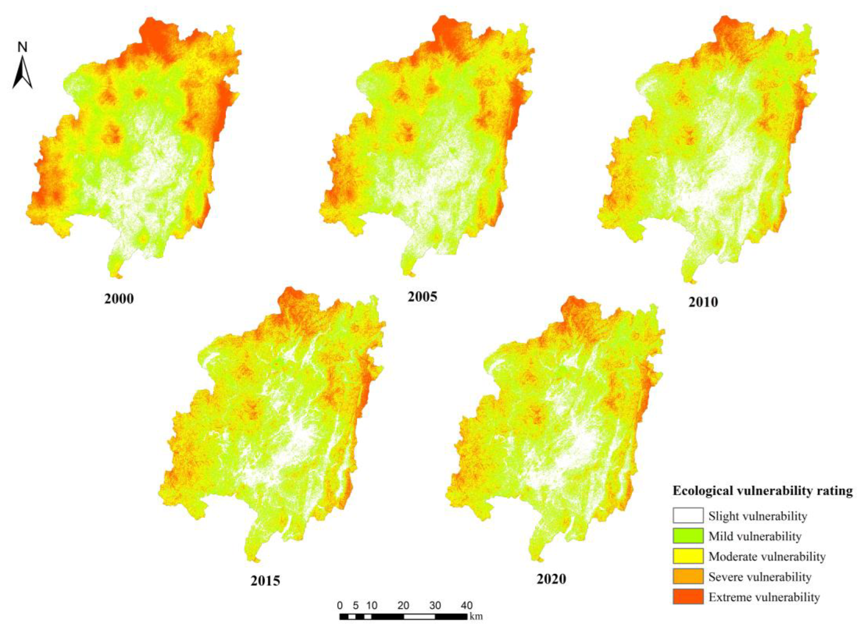
3.1. Temporal and Spatial Variation of Ecological Vulnerability

As shown in Table 3 and Figure 2, the ecological vulnerability of the red soil erosion area in Changting was mainly mild and moderate, accounting for approximately 50% of its total area, mainly concentrated in the central and southern red soil erosion area in Changting. From 2000 to 2020, the EVSI decreased by 9.49%, showing an overall downward trend in the mildly vulnerable range. From 2000 to 2005, the area of severe and extremely vulnerable zones in the urban region of red soil erosion area in Changting increased. However, from 2000 to 2020, the area of severe and extremely vulnerable zones reduced by 4.87% and 5.61%, mainly distributed in the local areas of Hongshan Township, Sidu Town, Tiechang Township, Anjie Township, Tongfang Town, Tingzhou Town, and Datong Town in Changting County, that is, the northwest, southwest, northeast, and southeast of red soil erosion area in Changting. Moreover, the northern part of the red soil erosion area in Changting was the most widely distributed. Still, the severe and extremely vulnerable areas had changed from a patchy distribution to a fragmented distribution. The slight, mild, and moderately vulnerable regions were primarily distributed in forest land and some cultivated areas in the central and southern parts of the red soil erosion area in Changting. The terrain is flat, and potential threats such as water and soil loss are small, and the area proportion increased by 2.32%, 5.31%, and 2.91% from 2000 to 2020, respectively.

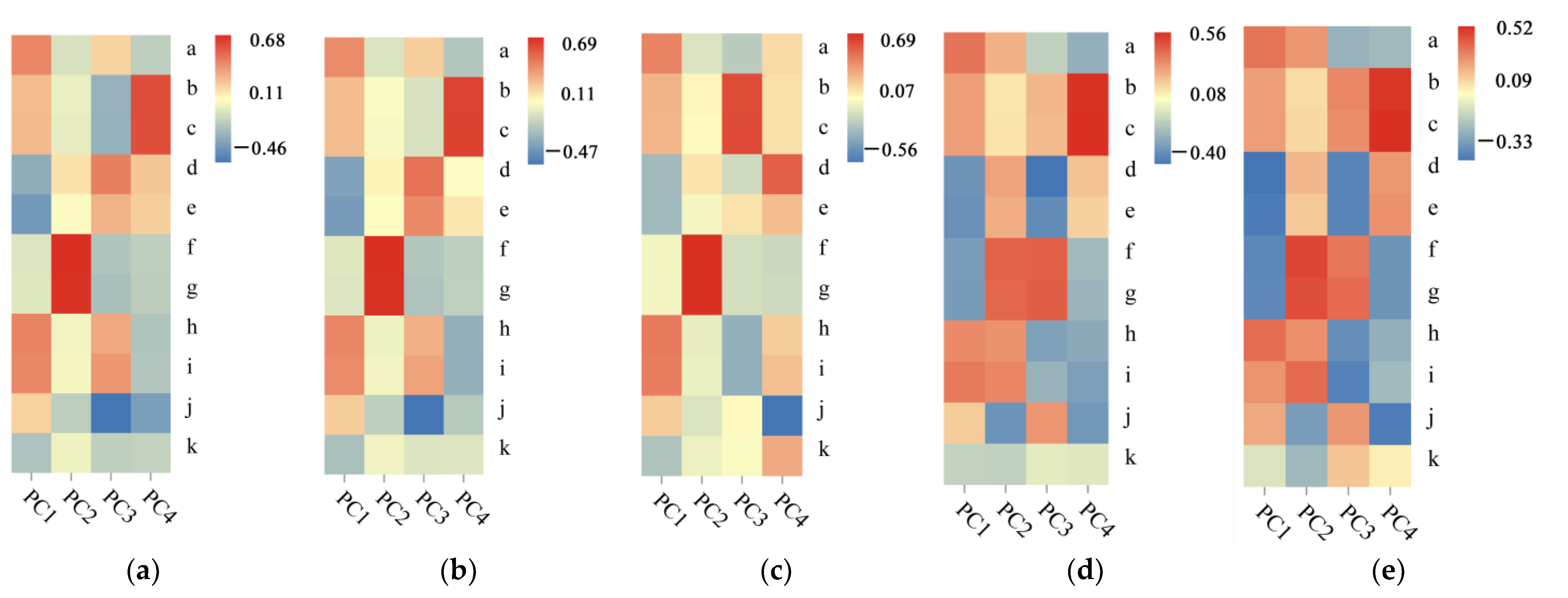
3.2. Analysis of the Driving Factors of Ecological Vulnerability

Evaluation indexes of ecological vulnerability in the red soil erosion zone of Changting from 2000 to 2020 that contributed more to principal component 1 were elevation, annual average precipitation, and annual average temperature; evaluation indexes with higher contribution to principal component 2 were population density and GDP density, which were consistent with the severe and extremely vulnerable areas in the red soil erosion zone. Land use type and landscape diversity index contributed more to principal component 3 in 2000 and principal component 4 in 2010. The contribution of relief degree of land surface and slope to principal component 4 in 2000, 2005, 2015, and 2020 and principal component 3 in 2010 was higher; population density and GDP density had a higher contribution to principal component 3 in 2015 and 2020. In summary, topography, meteorology, and socioeconomic conditions greatly impacted the ecological vulnerability index of the red soil erosion area in Changting. They were the main driving factors of ecological vulnerability (Figure 3).

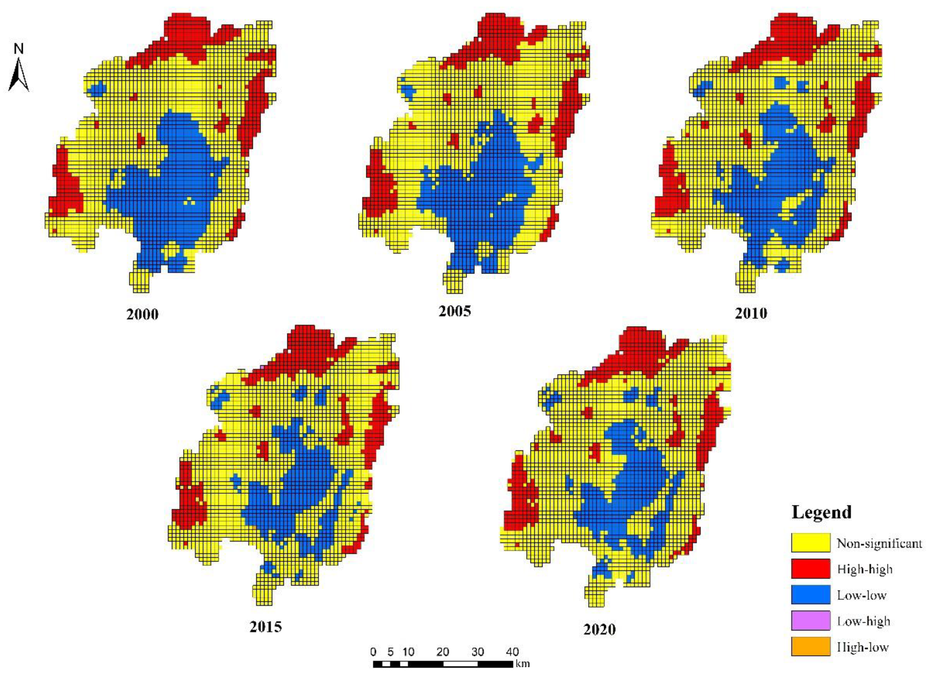
3.3. Spatial Agglomeration Characteristics of Ecological Vulnerability

3.3.1. Global Autocorrelation Analysis

It can be seen from Figure 4 that the Global Moran’s I of red soil erosion area in Changting from 2000 to 2020 were 0.963, 0.952, 0.935, 0.885, and 0.895, respectively. The ecological vulnerability of the red soil erosion area in Changting from 2000 to 2020 had a clear positive spatial autocorrelation. The ecological vulnerability had a clear clustering pattern in the spatial distribution of the red soil erosion area in Changting. The high ecological vulnerability area was adjacent to the high ecological vulnerability area, and the low ecological vulnerability area was adjacent to the low ecological vulnerability area. Moran’s I showed a decreasing trend, and the cluster phenomenon of the spatial distribution of ecological vulnerability in the red soil erosion area of Changting gradually weakened.
The Global Moran’s I scatter points of ecological vulnerability in the red soil erosion area of Changting from 2000 to 2020 were primarily divided into the first and third quadrants. This clearly showed that the ecological environment of the red soil erosion area in Changting was mainly divided into better and worse areas, and the difference between them was evident. From 2000 to 2010, the number of scatter points in the “high–high” cluster in the first quadrant was significantly more than the number of scatter points in the “low–low” cluster in the third quadrant, indicating that the number of clusters in areas with a better ecological environment was significantly more than in areas with a poor ecological environment. From 2015 to 2020, the number of scatter points of the “high–high” cluster in the first quadrant was similar to the number of scatter points of the “low–low” cluster in the third quadrant, which indicates that the number of clusters in areas with the better ecological environment is similar to that in areas with poor ecological environment. Therefore, the potential risk of ecological environment deterioration in the red soil erosion area of Changting is still significant. In addition to improving vegetation coverage and other methods to make up for the devastative impact on topography, climate, and other factors on the ecological environment, more devotion should be given to the damage to the ecological environment caused by the development of human society.

3.3.2. Local Autocorrelation Analysis

Figure 5 indicated that from 2000 to 2020, the “high–high” aggregation regions were distributed in severely vulnerable and extremely vulnerable areas, manifested as the grid with high ecological vulnerability was adjacent to the grid with high ecological vulnerability, showing an agglomeration distribution. These areas were mainly concentrated in Tiechang Township, Anjie Township, and part of Tongfang Township, Sidu Township, and Hongshan Township, but there was a slight expansion at the junction of Hetian Town, Xinqiao Town, and Tongfang Town. The “low–low” aggregation area was distributed in the slightly vulnerable and mildly vulnerable areas, mainly concentrated in the local regions of Cewu Township, Hetian Town, Sanzhou Township, Zhuotian Town, Tufang Town, Nanshan Town, Xuancheng Township, and Yanggu Township. However, the distribution range of “low–low” aggregation areas continued to shrink from 2000 to 2015, the spatial aggregation impact deteriorated into an inconsequential aggregation area, and there was no notable change after 2015.

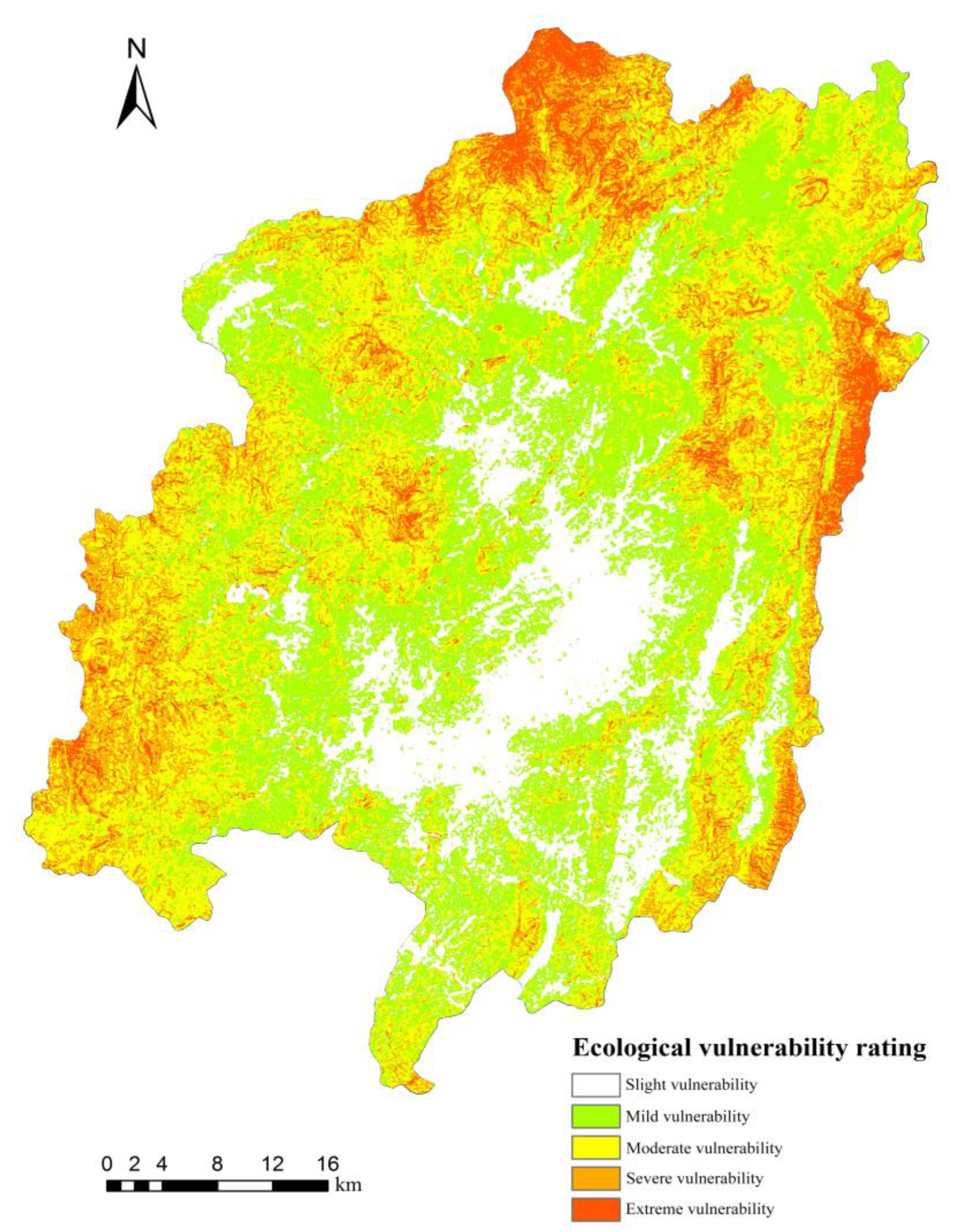
3.4. Ecological Vulnerability Prediction Results

The ecological vulnerability index of the red soil erosion area in Changting in 2020 had a Kappa coefficient test score of 0.884, showing that the CA-Markov model has good simulation accuracy and is appropriate for the simulation prediction in this paper. Similarly, the simulation and prediction results of the ecological vulnerability of the red soil erosion area in Changting for the next ten years are shown in Figure 6. Slight, mild, moderate, severe, and highly vulnerable regions account for 13.87%, 39.73%, 33.14%, 11.86%, and 1.23% of the total area of the study site, respectively, and the EVSI was 2.463. Compared with the ecological vulnerability index and EVSI from 2000 to 2020, the area of the mildly and moderately vulnerable regions enlarged significantly, and the size of severely and extremely vulnerable areas decreased. The EVSI value decreased by 0.65% compared with 2020, which was still in the range of mild vulnerability.

4. Discussion

The red soil erosion area of Changting covers a wide area and has a profound degree of water and soil loss. It is one of southern China’s red soil erosion zone’s most typical water and soil loss areas. Soil restoration of degraded agricultural land [24], forest regeneration [25], the spatial distribution of forest aboveground biomass, and reasonable tree density [26] are of great significance to the control of water and soil loss and the protection and restoration of ecosystem functions in the red soil erosion area of Changting. Therefore, in our evaluation index system, soil erosion intensity, normalized difference vegetation index, and landscape diversity were selected to reflect the water and soil loss, spatial forest distribution, forest density, the number of landscape elements, and the proportion of each landscape element in the study area.
Soil and water loss, the most serious ecological problem in the red soil erosion area of Changting, is mainly concentrated in the middle and south of the study area [7], which is different from the distribution of ecological vulnerability. It can be seen that the soil erosion intensity index has a low degree of influence in our study on the ecological vulnerability of the red soil erosion area in Changting. The impact of the soil erosion intensity index on the ecological vulnerability of the red soil erosion area in Changting is low. When Sun et al. [27] studied the driving mechanism of ecological vulnerability along the Sichuan–Tibet Railway, they also found that soil erosion intensity was not the main factor leading to the ecological vulnerability. After grading the soil erosion intensity, the spatial differences were minimal. This indicates that the soil erosion intensity index is unsuitable for areas with small differences in erosion intensity for ecological vulnerability assessment. The impact of the normalized difference vegetation index and landscape diversity on ecological vulnerability is higher; that is, the ecological vulnerability level of areas with higher normalized difference vegetation index and landscape diversity is lower, indicating that strengthening forest planting and forest regeneration is beneficial to ecological environment restoration.
According to the SRP model, Chen et al. [28] estimated the soil erosion vulnerability of Zhuxi watershed in Changting County. They found that the rate of soil erosion vulnerability progressively declined from medium-high to mild. According to our findings, the proportion of ecologically severe and highly vulnerable areas in Changting’s red soil erosion area decreased significantly between 2000 and 2020, while the proportion of slightly, mildly, and moderately vulnerable regions increased, with the majority being mildly vulnerable. The change law of ecological vulnerability in the red soil erosion area of Changting we found is the same as that of soil erosion vulnerability in Changting Zhuxi watershed found by Chen et al. [28], but the degree of vulnerability is different. This is mainly because the research scale and region are different. The vulnerability level is usually based on the comparative size of the vulnerability in the study area. Different research scales and areas will naturally lead to poor comparability of research results. When studying the ecological vulnerability of the Yellow River Basin, Zhang et al. [29] selected different spatial resolutions of land cover, nighttime light data, and evapotranspiration layer data. By interpolating the data, the spatial resolutions of different data were consistent, and the research results were consistent with the actual situation, indicating that data with different resolutions can meet the general research requirements. Similarly, María Berrouet et al. [30] combined climate, land use, and other socioeconomic indicators to analyze the vulnerability of social-ecological systems and construct a conceptual framework. The author also selected indicators of different spatial resolutions in different dimensions to construct a conceptual framework. When we evaluated the ecological vulnerability of the red soil erosion area in Changting, the spatial resolution of the selected evaluation indicators was different; however, the accuracy of the data with relatively coarse spatial resolution could also reach 30 m after interpolation. The final research results showed that they were consistent with the actual ecological environment of the red soil erosion area in Changting, indicating that this data processing method could be used in this study.
Different ecological vulnerability assessment models are suitable for various research fields. Studies have shown that the VSD model based on Exposure–Sensitivity–Adaptive capacity can well reflect the ecological vulnerability caused by climate change [31]. Okey et al. [32] used the VSD model to assess the vulnerability of the Canadian Pacific Ocean ecosystem under climate change from the perspectives of seawater temperature, ultraviolet radiation, and seawater acidification. The model provided a reference for possible factors of ecosystem vulnerability caused by climate change. The PSR model established a wetland vulnerability assessment index system involving environmental, ecological, social, and economic factors. According to the PSR model, Zhang et al. [33] built a Pressure–Support–State–Response (PSSR) model to analyze the flexibility of the Yellow River Delta’s wetland ecosystem to human activity. Its ecosystem’s vulnerability was assessed using the landscape diversity index, the evenness index, and the average degree of wetland elasticity. Its ecosystem was more affected by the number of people living there, the number of human disturbances, and the amount of pollution. This model helped protect, develop, and make policy for wetland areas in the Yellow River Delta on a theoretical level. Under the premise of thoroughly assessing the stability of the ecosystem, the SRP model comprehensively represents the vulnerability of the regional ecological environment based on multi-level and comprehensive evaluation indexes from the perspective of the natural and social economy [34]. We employed the SRP model to select elevation, soil erosion intensity, population density, and other indicators to evaluate the ecological vulnerability of the red soil erosion areas in Changting. The current study showed that the severely and tremendously vulnerable regions were primarily distributed in the northwest, southwest, northeast, and southeast of the red soil erosion area in Changting. Using local natural and socioeconomic data, Lin et al. [35] determined that the regions with high ecological vulnerability in the red soil erosion region of Changting had a high altitude and steep slope; different altitudes and terrains led to different water and heat conduction capabilities in different areas. The yearly average precipitation and temperature showed significant regional differences and contributed to ecological vulnerability [36]. That is, topography, meteorology, and other natural background factors significantly impacted the ecological vulnerability of the red soil erosion area in Changting. Additionally, areas with a dense population and economic activities caused strong disturbance to the ecosystem. A combination of natural and socioeconomic factors accurately evaluated the ecological vulnerability of the red soil erosion area in Changting. Therefore, we believe the SRP model is more suitable for ecological vulnerability assessment of the red soil erosion area than the VSD and PSR models. Its evaluation index is more comprehensive, taking into account the impact of socioeconomic factors on the ecological environment more, and is more easily obtained.
Some scholars use the analytic hierarchy process (AHP) to regulate the weight of the Tarim River Basin’s ecological vulnerability index [37]. However, only experienced researchers can logically use the subjective evaluation method (such as AHP) to determine the standard weight accurately. Gupta et al. [38] employed the principal spatial component analysis method to assess the vulnerability of the social and environmental systems to climate change at different elevation gradients in the Himalayas of India. It was discovered that, compared to subjective evaluation methods such as the analytic hierarchy process, the spatial principal component analysis method could improve the precision of the estimation results by removing redundant information between the indicators and certifying the objectivity of the assessment results. Our study used spatial principal component analysis to calculate the weight of 11 evaluation indexes, which not only retains the original information as much as possible but also avoids a lot of repeated calculation and subjective randomness. The selection of an ecological vulnerability assessment model and a prediction method directly affects the evaluation results. Yao et al. [39] employed the CA-Markov model to simulate the ecological vulnerability of the middle and upper ranges of the Yalong River in 2015. The results showed that the Kappa coefficient test value was 0.858. The ecological vulnerability index of the red soil erosion area in Changting in 2020 was simulated using the same model. The Kappa coefficient test result between the prediction model and the actual condition was 0.884, which shows that the prediction model is appropriate for simulating and forecasting short-term ecological vulnerability at a lower scale.

5. Conclusions

A comprehensive measure of ecological vulnerability shows a declining trend for the red soil erosion region in Changting from 2000 to 2020. Consistent with the actual scenario, the size of severe and highly vulnerable areas shrunk, while the mild and moderately vulnerable areas grew. Topography, meteorology, and social economy were the main driving factors; strengthening forest restoration is also conducive to ecological environment restoration. The distribution area has been in the northwest, southwest, northeast, and southeast of the red soil erosion area in Changting. Comparing the actual ecological vulnerability index in 2020 with the simulation results of the CA–Markov model, the Kappa coefficient was 0.884. The ecological vulnerability was distributed with a clear clustering pattern. The comprehensive index of ecological vulnerability and the region of severely and enormously vulnerable areas in the red soil erosion zone of Changting will decrease in the next ten years. According to the current study, SRP and CA-Markov models can better evaluate the ecological vulnerability of the red soil erosion region and predict short- and medium-term outcomes.

Author Contributions

Conceptualization, X.W. and X.H.; methodology, X.W., H.Z., K.Y. and X.H.; software, X.W., H.Z. and K.Y.; validation, X.W. and X.H.; formal analysis, X.H.; investigation, C.Z., J.Y. and L.Z.; resources, X.W.; data curation, X.W.; writing—original draft preparation, X.W.; writing—review and editing, X.W. and X.H.; visualization, X.W.; supervision, X.H.; funding acquisition, X.H. All authors have read and agreed to the published version of the manuscript.

Funding

This work was supported by the Natural Science Foundation of Fujian Province (grant number 2022J01121), the National Natural Science Foundation of China (grant number 32201572), and the Interdisciplinary Integration Fund of Fujian Agriculture and Forestry University (grant numbers 712021030, 71202103D).

Data Availability Statement

The data and data sources used in this paper are presented in Section 2.2.1 as part of the paper. The description will not be repeated here.

Conflicts of Interest

The authors declare no conflict of interest.

References

  1. Beroya-Eitner, M.A. Ecological vulnerability indicators. Ecol. Indic. 2016, 60, 329–334. [Google Scholar] [CrossRef]
  2. Xu, Z.H.; Gong, C.H.; Liu, J.; Yu, K.Y.; Lai, R.W.; Li, Z.L. Estimation of leaf area index of Pinus massoniana forest by using canopy density and HJ-1 multi-spectral data. J. Plant Resour. Environ. 2013, 22, 29–35. [Google Scholar]
  3. Wu, X.X.; Gu, Z.J. Contribution Weight of Forest Canopy and Grass Layers to Soil and Water Conservation on Water-Eroded Areas in Southern China. Eurasian Soil Sci. 2020, 53, 1004–1012. [Google Scholar]
  4. Eakin, H.; Luers, A.L. Assessing the Vulnerability of Social-Environmental Systems. Annu. Rev. Env. Resour. 2006, 31, 365–394. [Google Scholar] [CrossRef] [Green Version]
  5. Shao, H.Y.; Sun, X.F.; Wang, H.X.; Zhang, X.X.; Xiang, Z.Y.; Tan, R.; Chen, X.Y.; Xian, W.; Qi, J.G. A method to the impact assessment of the returning grazing land to grassland project on regional eco-environmental vulnerability. Environ. Impact Asses. 2016, 56, 155–167. [Google Scholar] [CrossRef]
  6. Nguyen, A.K.; Liou, Y.A.; Li, M.H.; Tran, T.A. Zoning eco-environmental vulnerability for environmental management and protection. Ecol. Indic. 2016, 69, 100–117. [Google Scholar] [CrossRef]
  7. Hu, X.J.; Ma, C.M.; Huang, P.; Xu, G. Ecological vulnerability assessment based on AHP-PSR method and analysis of its single parameter sensitivity and spatial autocorrelation for ecological protection—A case of Weifang City, China. Ecol. Indic. 2021, 125, 107464. [Google Scholar] [CrossRef]
  8. Dossou, J.F.; Li, X.X.; Sadek, M.; Almouctar, M.A.S.; Mostafa, E. Hybrid model for ecological vulnerability assessment in Benin. Sci. Rep. 2021, 11, 1–15. [Google Scholar] [CrossRef] [PubMed]
  9. Song, G.B.; Li, Z.; Yang, Y.G.; Semakula, H.M.; Zhang, S.S. Assessment of ecological vulnerability and decision-making application for prioritizing roadside ecological restoration: A method combining geographic information system, Delphi survey and Monte Carlo simulation. Ecol. Indic. 2015, 52, 57–65. [Google Scholar] [CrossRef]
  10. Wu, C.S.; Liu, G.H.; Huang, C.; Liu, Q.S.; Guan, X.D. Ecological Vulnerability Assessment Based on Fuzzy Analytical Method and Analytic Hierarchy Process in Yellow River Delta. Int. J. Environ. Res. Public Health. 2018, 15, 855. [Google Scholar] [CrossRef] [PubMed] [Green Version]
  11. Luo, J.; Zhang, X.B.; Ding, H.M. Study on the Spatial-temporal Differentiation and Driving Mechanism of Ecological Vulnerability in Zhangye City. IOP Conf. Ser. Mater. Sci. Eng. 2020, 780, 072056. [Google Scholar]
  12. Li, Y.; Tian, Y.P.; Li, C.K. Comparison Study on Ways of Ecological Vulnerability Assessment—A Case Study in the Hengyang Basin. Procedia Environ. Sci. 2011, 10, 2067–2074. [Google Scholar] [CrossRef] [Green Version]
  13. Jin, Y.; Meng, J. Assessment and forecast of ecological vulnerability: A review. Chin. J. Ecol. 2011, 30, 2646–2652. [Google Scholar]
  14. Aretano, R.; Semeraro, T.; Petrosillo, I.; De Marco, A.; Pasimeni, M.R.; Zurlini, G. Mapping ecological vulnerability to fire for effective conservation management of natural protected areas. Ecol. Model. 2015, 295, 163–175. [Google Scholar] [CrossRef]
  15. Dai, X.; Gao, Y.; He, X.; Liu, T.; Jiang, B.; Shao, H.; Yao, Y. Spatial-temporal pattern evolution and driving force analysis of ecological environment vulnerability in Panzhihua City. Environ. Sci. Pollut. Res. 2021, 28, 1–16. [Google Scholar] [CrossRef] [PubMed]
  16. Wang, C.C.; Yang, Y.S.; Zhang, Y.Q. Cost-Effective Targeting Soil and Water Conservation: A Case Study of Changting County in Southeast China. Land Degrad. Dev. 2016, 27, 387–394. [Google Scholar] [CrossRef]
  17. Zhou, Q.W.; Luo, Y.; Zhou, X.; Cai, M.Y.; Zhao, C.W. Response of vegetation to water balance conditions at different time scales across the karst area of southwestern China—A remote sensing approach. Sci. Total Environ. 2018, 645, 460–470. [Google Scholar] [CrossRef]
  18. Spalevic, V.; Djurovic, N.; Mijovic, S.; Vukelic-Shutosk, M.; Curovic, M. Soil erosion intensity and Runoff on the Djuricka river basin (North of Montenegro). Malays. J. Soil Sci. 2013, 17, 1–17. [Google Scholar]
  19. Wu, X.L.; Tang, S.Y. Comprehensive evaluation of ecological vulnerability based on the AHP-CV method and SOM model: A case study of Badong County, China. Ecol. Indic. 2022, 137, 108758. [Google Scholar] [CrossRef]
  20. Zang, Z.; Zou, X.Q.; Zuo, P.; Song, Q.C.; Wang, C.L.; Wang, J.J. Impact of landscape patterns on ecological vulnerability and ecosystem service values: An empirical analysis of Yancheng Nature Reserve in China. Ecol. Indic. 2017, 72, 142–152. [Google Scholar] [CrossRef]
  21. Liu, Q.; Shi, T.G. Spatiotemporal Differentiation and the Factors of Ecological Vulnerability in the Toutun River Basin Based on Remote Sensing Data. Sustainability 2019, 11, 4160. [Google Scholar] [CrossRef] [Green Version]
  22. Song, G.B.; Chen, Y.; Tian, M.R.; Lv, S.H.; Zhang, S.S.; Liu, S.L. The Ecological Vulnerability Evaluation in Southwestern Mountain Region of China Based on GIS and AHP Method. Procedia Environ. Sci. 2010, 2, 465–475. [Google Scholar] [CrossRef] [Green Version]
  23. Faichia, C.; Tong, Z.J.; Zhang, J.Q.; Liu, X.P.; Kazuva, E.; Ullah, K.; Al-Shaibah, B. Using RS Data-Based CA-Markov Model for Dynamic Simulation of Historical and Future LUCC in Vientiane, Laos. Sustainability 2020, 12, 8410. [Google Scholar] [CrossRef]
  24. Mosier, S.; Córdova, S.C.; Robertson, G.P. Restoring Soil Fertility on Degraded Lands to Meet Food, Fuel, and Climate Security Needs via Perennialization. Front. Sustain. Food Syst. 2021, 5, 706142. [Google Scholar] [CrossRef]
  25. Qiu, T.; Andrus, R.; Aravena, M.C.; Ascoli, D.; Bergeron, Y.; Berretti, R.; Berveiller, D.; Bogdziewicz, M.; Boivin, T.; Bonal, R. Limits to reproduction and seed size-number trade-offs that shape forest dominance and future recovery. Nat. Commun. 2022, 13, 2381. [Google Scholar] [CrossRef] [PubMed]
  26. Ledo, A.; Illian, J.B.; Schnitzer, S.A.; Wright, S.J.; Dalling, J.W.; Burslem, D.F.R.P. Lianas and soil nutrients predict fine-scale distribution of aboveground biomass in a tropical moist forest. J. Ecol. 2016, 104, 1819–1828. [Google Scholar] [CrossRef] [Green Version]
  27. Sun, Y.Q.; Yang, X.; Hao, L.N. Spatial and temporal differentiation and driving mechanism of ecological vulnerability along Sichuan-Tibet railway during 2010-2020 based on SRP model. Bull. Soil Water Conserv. 2021, 41, 201–208. [Google Scholar]
  28. Chen, S.F.; Zha, X.; Bai, Y.H.; Wang, L.Y. Evaluation of soil erosion vulnerability on the basis of exposure, sensitivity, and adaptive capacity: A case study in the Zhuxi watershed, Changting, Fujian Province, Southern China. Catena 2019, 177, 57–69. [Google Scholar] [CrossRef]
  29. Zhang, X.Y.; Liu, K.; Wang, S.D.; Wu, T.X.; Li, X.K.; Wang, J.N.; Wang, D.C.; Zhu, H.T.; Tan, C.; Ji, Y.H. Spatiotemporal evolution of ecological vulnerability in the Yellow River Basin under ecological restoration initiatives. Ecol. Indic. 2022, 135, 108586. [Google Scholar] [CrossRef]
  30. Maria Berrouet, L.; Machado, J.; Villegas-Palacio, C. Vulnerability of socio—Ecological systems: A conceptual Framework. Ecol. Indic. 2018, 84, 632–647. [Google Scholar] [CrossRef]
  31. Bernhardt, J.R.; Leslie, H.M. Resilience to Climate Change in Coastal Marine Ecosystems. Ann. Rev. Mar. 2013, 5, 371–392. [Google Scholar] [CrossRef] [PubMed] [Green Version]
  32. Okey, T.A.; Agbayani, S.; Alidina, H.M. Mapping ecological vulnerability to recent climate change in Canada’s Pacific marine ecosystems. Ocean Coast Manag. 2015, 106, 35–48. [Google Scholar] [CrossRef]
  33. Zhang, X.Q.; Wang, L.K.; Fu, X.S.; Li, H.; Xu, C.D. Ecological vulnerability assessment based on PSSR in Yellow River Delta. J. Clean Prod. 2017, 167, 1106–1111. [Google Scholar] [CrossRef]
  34. Kan, A.K.; Li, G.Q.; Yang, X.; Zeng, Y.L.; Tesren, L.; He, J. Ecological vulnerability analysis of Tibetan towns with tourism-based economy: A case study of the Bayi District. J. Mt. Sci. 2018, 15, 1101–1114. [Google Scholar] [CrossRef]
  35. Lin, C.; Zhou, S.L.; Wu, S.H.; Liao, F.Q. Relationships between Intensity Gradation and Evolution of Soil Erosion: A Case Study of Changting in Fujian Province, China. Pedosphere 2012, 22, 243–253. [Google Scholar] [CrossRef]
  36. Qiao, H. Review of comprehensive evaluation of principal component and its applicability. J. Tianjin Univ. Commer. 2015, 35, 9–14. [Google Scholar]
  37. Xue, L.Q.; Wang, J.; Zhang, L.C.; Wei, G.H.; Zhu, B.L. Spatiotemporal analysis of ecological vulnerability and management in the Tarim River Basin, China. Sci. Total Environ. 2019, 649, 876–888. [Google Scholar] [CrossRef]
  38. Gupta, A.K.; Negi, M.; Nandy, S.; Alatalo, J.M.; Singh, V.; Pandey, R. Assessing the vulnerability of socio-environmental systems to climate change along an altitude gradient in the Indian Himalayas. Ecol. Indic. 2019, 106, 105512.1–105512.11. [Google Scholar] [CrossRef]
  39. Yao, K.; Zhang, C.J.; He, L.; Li, Y.X.; Li, X.J. Dynamic evaluation and prediction of ecological environment vulnerability in the middle-upper reaches of the Yalong River. Remote Sens. Nat. Resour. 2020, 32, 199–208. [Google Scholar]
Figure 1. Location diagram of the study area.
Forests 13 02136 g001
Figure 2. Spatial distribution of ecological vulnerability in red soil erosion area of Changting from 2000 to 2020.
Forests 13 02136 g002
Figure 3. Index weights of ecological vulnerability assessment in red soil erosion area of Changting from 2000 to 2020. (ae) represent 2000, 2005, 2010, 2015 and 2020, respectively. a stands for elevation, b stands for slope, c stands for relief degree of land surface, d stands for land use type, e stands for NDVI, f stands for population density, g stands for GDP density, h stands for annual average temperature, i stands for annual average precipitation, j stands for landscape diversity, and k represents soil erosion intensity.
Forests 13 02136 g003
Figure 4. Global Moran’s I scatter plot of ecological vulnerability in red soil erosion area of Changting from 2000 to 2020. The x-axis represents the ecological vulnerability of each year, and the y-axis represents the spatial lag of the ecological vulnerability of each year. The farther the distance from the baseline, the stronger the spatial lag and the weaker the spatial agglomeration.
Forests 13 02136 g004
Figure 5. LISA cluster maps of ecological vulnerability in red soil erosion area of Changting from 2000 to 2020. The “high–high” areas represent hot spots of ecological vulnerability, and the “low–low” areas represent the cold spots of ecological vulnerability. The “low–high“ area represents the hot spots near the cold spot of ecological vulnerability, the “high–low“ area represents the cold spots near the hot spot of ecological vulnerability. (“Low–high” and “high–low” area almost do not exist).
Forests 13 02136 g005
Figure 6. Prediction map of ecological vulnerability in red soil erosion area of Changting.
Forests 13 02136 g006
Table 1. Assessment index system of ecological vulnerability.
Target LayerCriterion LayerFactor LayerIndex LayerIndex Properties
Ecological vulnerabilityEcological sensitivityTopographic factorsElevationPositive
SlopePositive
Relief degree of land surfacePositive
Meteorological factorsAnnual average temperatureNegative
Annual average precipitationPositive
Surface factorsSoil erosion intensityQualitative
Land use typeQualitative
Ecological resilienceVegetation factorNDVINegative
Landscape structureLandscape diversityNegative
Ecological pressureSocioeconomic factorsPopulation densityPositive
GDP densityPositive
Table 2. Ecological vulnerability classification.
Criterion LayerFactor LayerIndex Layer
Ecological vulnerability ratingStandardized value of ecological vulnerability indexEcological characteristics
Slight vulnerability (I)Si ≤ 1.827The ecosystem structure is stable, function is perfect, pressure on the ecological environment is small, ecological resilience and anti-interference abilities are strong, and there is no ecological anomaly.
Mild vulnerability (II)1.827 < Si ≤ 2.800The ecosystem structure is relatively stable, function is relatively perfect, ecological environment is under less pressure, ecological resilience and anti-interference abilities are relatively strong, ecological environment has potential abnormalities, and ecological vulnerability is relatively low.
Moderate vulnerability (III)2.800 < Si ≤ 3.773The ecosystem structure is relatively unstable, and self-resilience and anti-interference abilities are relatively weak; although the ecological pressure is at an acceptable level, it has reached a critical value, and a small number of ecological anomalies have occurred.
Severe vulnerability (IV)3.773 < Si ≤ 4.973The ecosystem structure is unstable, ecological function is degraded to a certain extent, sensitivity to external interference is strong, self-recovery and anti-interference abilities are relatively poor, and ecological environment problems are relatively serious.
Extreme vulnerability (V)Si > 4.973The ecosystem structure is extremely unstable, ecological function is seriously degraded, sensitivity to external interference is strong, self-recovery and anti-interference abilities are poor, and the ecological environment has serious ecological anomalies.
Table 3. Ecological vulnerability assessment of red soil erosion area in Changting from 2000 to 2020.
YearsProportion of Slight Vulnerability (%)Proportion of Mild Vulnerability (%)Proportion of Moderate Vulnerability (%)Proportion of Severe Vulnerability (%)Proportion of Extreme Vulnerability (%)EVSI
200019.1726.4624.9919.949.392.74
200519.0028.7326.9317.897.452.66
201026.4731.6524.5513.184.162.37
201518.2930.5529.8316.874.452.59
202021.4931.7727.9015.073.782.48
Publisher’s Note: MDPI stays neutral with regard to jurisdictional claims in published maps and institutional affiliations.

