Abstract
In this paper, we demonstrate how subfossil mangrove wood can be used to elucidate the timing of past tsunami events. Although tsunamis generated by submarine earthquakes along the Makran subduction zone in the Arabian Sea are not unusual, rigorous age documentation is generally lacking. The best known is the only instrument-recorded tsunami, which affected the coastlines of Iran, Pakistan, India, and Oman in November 1945. Eyewitness accounts of the effect along the Oman coastline assert that this tsunami was not destructive. However, a 25-cm-thick shell layer in the lagoon adjacent to the city of Sur was attributed to the 1945 tsunami, although dating of the shell deposit proved difficult, and the radiocarbon dates of mollusk shells were regarded as unreliable. Here, we reinterpret the age of this tsunamigenic layer based on the new discovery of parallel-oriented woody axes in the sedimentological context of the tsunami shell layer in the Sur lagoon. The woody axes were analyzed anatomically and identified as pertaining to the gray mangrove Avicennia. Radiocarbon dating of the wood (905–722 cal BP), along with sedimentological investigations, suggests that the deposition of the woody axes should be attributed to an older tsunami event that occurred ca. 1000 years ago, which has been documented at other locations along the Arabian Sea coastline. From this, we conclude that mangroves grew in this lagoon at that time. Very little is known about ancient mangrove distribution in this region and, so far, no records have been provided for this time window at this site. We also deduce that the tsunami event that occurred one millennium ago must have been substantially more severe than the one in 1945. More accurate dating of tsunamigenic events will aid in calculating the recurrence intervals and magnitude of tsunamis generated along the Makran subduction zone.
1. Introduction
Despite huge scientific advances in recent years [1], the vulnerability of coastal areas to the risk of tsunamis remains high [2]. Due to the rapid, unpredictable, wave-triggering geodynamic processes that can produce catastrophic geological events along coastlines, early warning systems for tsunamis are increasingly being installed within ocean basins to monitor seismic activity and to mitigate coastal and inland damage. Studies of recent extreme wave events and the devastation they cause on land show that mangrove stands can significantly reduce the energy of tsunami waves [3]. Although the degree of potential protection of mangroves is widely discussed in more recent reviews [4,5], large-scale reforestation programs and mangrove protection in many parts of the world are intended to make coasts safer again [6]. To estimate the risk of oceanic extreme wave events with overpowering and often fatal outcomes on shore, recurrence intervals have come under archeological and sedimentological study [7,8]. The reconstruction of tsunami events becomes more uncertain the further back they occurred in the past, due to the nature of these archives, preservation potential, and dating uncertainties.
The Makran subduction zone (MSZ) in the Gulf of Oman marks the convergence of the Eurasian and Arabian Plates. Located on a narrow extension of the northeastern Indian Ocean, this subduction zone extends from west to east over a distance of at least 1000 km [9]. The Arabian Plate is subducting at a rate of ~4 cm/year and, at 4.5° [10], the dip angle of the incoming plate is shallow; the seismicity is low compared to other subduction zones. Concentrated seismicity is recorded in the eastern part, while it is seismically quiet to the west. The seismogenic potential of the MSZ is among the most enigmatic in the world [11]. The trench of the megathrust is filled with a sequence of organic-rich sediments of up to 7 km thickness [12], hampering geophysical investigations. Furthermore, historical seismicity along the MSZ is low [9]. Subduction earthquakes have resulted in tsunamis affecting adjacent coastlines. Another tsunami-triggering process in this area is submarine sliding [13].
The only tsunamigenic earthquake instrumentally recorded along the MSZ had a magnitude of MW 8.1 and occurred on 27 November 1945. Eyewitness accounts collected along the coasts bordering the Arabian Sea in the Northern Indian Ocean [14] report that, while tsunami waves severely impacted the coastlines of today’s Iran, Pakistan, and India, they only affected the coastline of Oman in a minor way. Sedimentological evidence attributed to this tsunami event by [15] includes a shell layer up to 25 cm thick in the Sur lagoon on the Oman shoreline. However, the deposition of such a thick shell layer contradicts the eyewitness reports that describe the tsunami as having very little impact in Oman.
Since the age of the tsunami layer in the Sur lagoon was poorly defined by previous studies, we revisited the site in search of material suitable for radiocarbon dating. Here, we present new sedimentological and paleontological evidence for the shell layer having originated from a powerful tsunami event, and offer a new interpretation of its age.
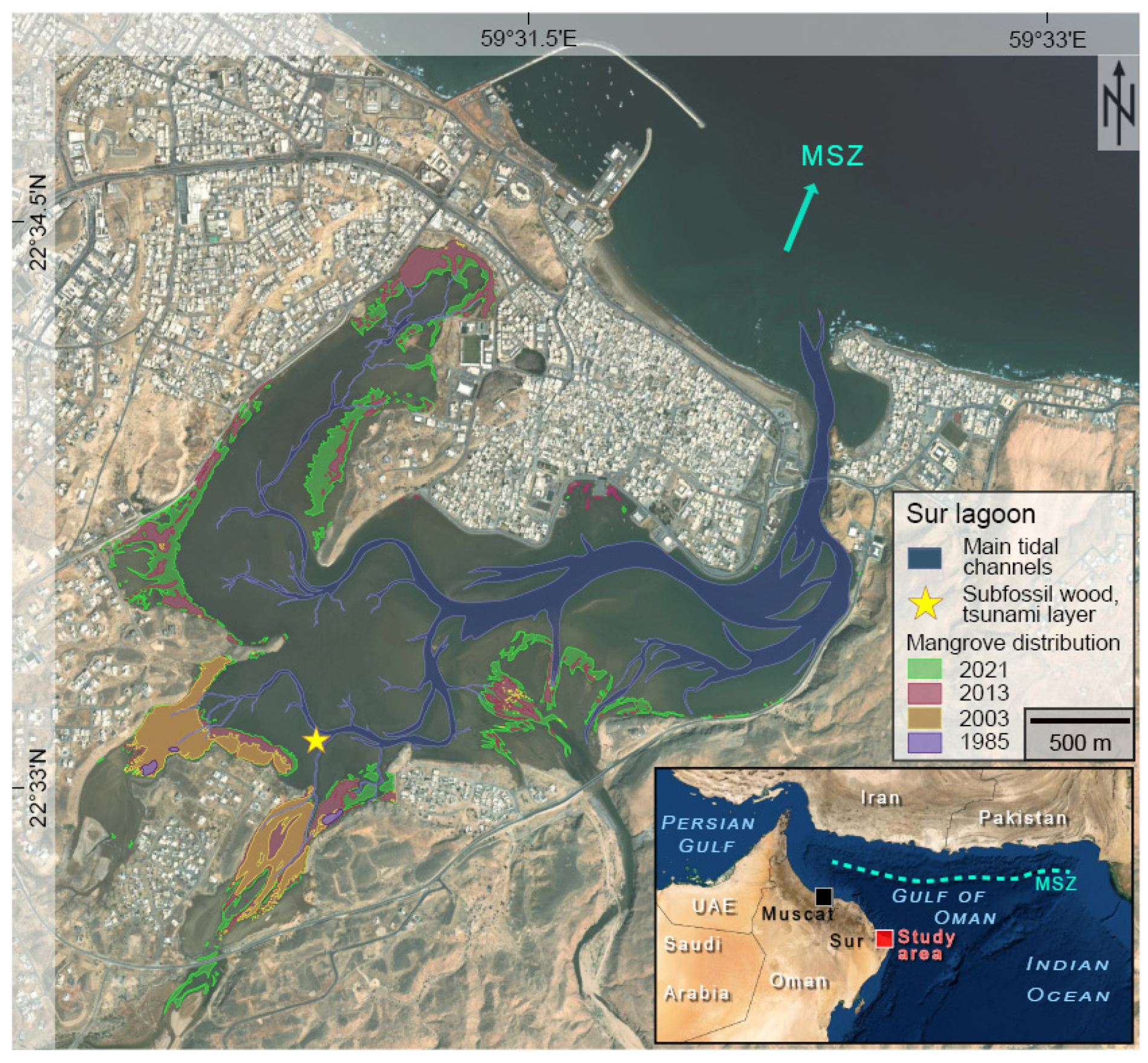
Located on the eastern edge of the Arabian Peninsula, the northeastern coast of Oman is directly exposed to the MSZ. A large city of historical importance, Sur (Figure 1), is situated here and borders a 5 km2 horseshoe-shaped lagoon, Khor al Batah. The Sur lagoon is separated from the open sea by a Holocene beach barrier spit system. The oldest part of Sur is located on top of this spit, which is elevated 2–3 m above mean sea level. Tides are semi-diurnal, and the tidal range in the outer coast is 3 m. The sea is connected to the lagoon via a 1 km-long channel with a width of at least 110 m. Khor al Batah is microtidal, with a tidal range of 1.2 m [15], and is almost completely dry during low tide. A well-developed tidal channel system, which drains the large intertidal flats, exists within the lagoon (Figure 1). These intertidal flats are dominated by siliciclastic fine sand bearing mollusks and foraminifera, while coarser material is observed in the tidal channels.
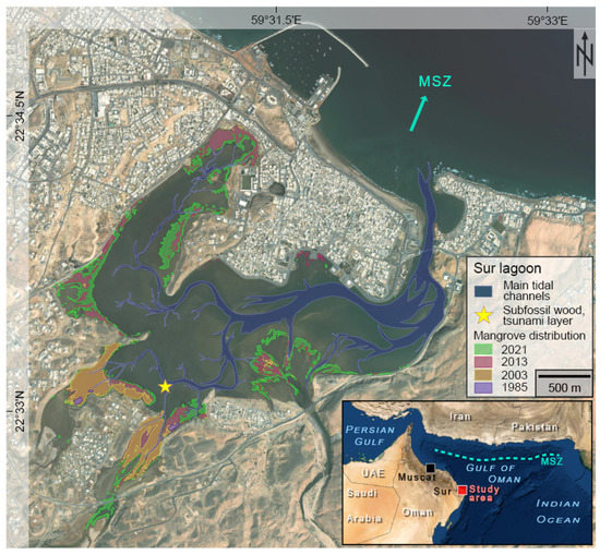
Figure 1.
Aerial photo of the Sur lagoon, showing the recent tidal channel system in blue and the modern mangrove distribution in green. The pink, brown, and purple colors indicate mangrove distribution in 2013, 2003, and 1985, respectively. The star marks the trench site, and the turquoise arrow points towards the Makran subduction zone (MSZ) (source: satellite image from Google Maps). Inset: location of the study area in Oman on the northeastern Arabian Peninsula (source: ESRI data, map created using ArcGIS 2015).
The lagoon is fringed by stands of the gray mangrove Avicennia marina (Forssk.) Vierh. (family Acanthaceae), with greatest densities along the southern shores where freshwater input is highest.
During the Holocene Humid Period, a period of higher precipitation around 8000–6000 cal BP ago, mangroves of the species Avicennia marina and Rhizophora mucronata Lam. were common along the northern and eastern coastlines of Oman [16]. Climate change and accompanying aridification owing to a southward shift of the Intertropical Convergence Zone (ITCZ) led to the collapse of several mangrove ecosystems along the eastern coastline [17]. Some very sheltered mangrove stocks could survive this radical change in environmental conditions, e.g., those in the lagoon of Jaramah in the north and those near Filim in the east [18].
Archaeological evidence reveals the extensive exploitation of mangroves by humans from the beginning of the Bronze Age. Its extraordinarily high calorific value made it a popular firewood and a popular charcoal wood for copper production [19,20]. Additionally, mangroves have always served as suitable livestock fodder and are also used as construction wood [21]. A growing population that mainly feeds on animal protein and adheres to pasturing methods causes ever-increasing grazing pressure. Charcoal production placed even more stress on the mangrove ecosystems.
Little is known about mangrove distribution from the end of this Holocene Humid Period to recent times. Palynological investigations document an extinction of Rhizophora mucronata and a continuous occurrence of Avicennia marina in northeastern Oman [16,18].
These species differ from one another in their tolerances towards ecological parameters. A. marina is known as the most robust mangrove species and is anatomically adapted to higher salinities and drier climate than R. mucronata [22,23]. It can also cope with different substrate types and can withstand cold temperatures and short freezing periods in the winter months [24]. R. mucronata is much more sensitive, especially towards salinity and temperature. Thus, expansion of mangroves is often limited by cold and dry climates [24]. Though humans have always exploited mangrove ecosystems, the disappearance of only R. mucronata and the continuous occurrence of A. marina in Oman mainly reflect a shift in climatic conditions [17,25].
From the 1980s onwards, we can monitor the development of mangrove cover via satellite images. According to these images, only solitary mangrove trees grew along the coastline of the lagoon in Sur in the 1980s (Figure 1). However, urban expansion and waste dumping since ancient times, and especially in the last few decades, have become enormous threats to the mangroves. According to [25], mangroves covered 2.06 km2 of the northern Omani coastline towards the Gulf of Oman in 1977; their areal extent decreased during the 1980s, but then expanded to 5.3 km2 in 2017 due to a governmental mangrove reforestation program. Today, only Avicennia marina mangroves are present in Oman. They grow as dwarf-shrub-like forms along the northern coastline, e.g., in Qurum and Sur, and develop dense stands with up to 5 m high trees within a sheltered bay near Filim in the east. Expansion of mangrove habitats, as has been seen in Qurum, Sur, and Filim, is a consequence of environmental protection and reforestation programs.
The erosional processes during and after a tsunami event limit the preservation of ancient tsunami records [26,27,28]. The mangrove-fringed, lagoonal setting of Sur offers a protected depositional environment with good preservation potential.
2. Materials and Methods
2.1. Fieldwork
Fieldwork in the Sur lagoon was carried out in spring 2020. The southwestern part of the lagoon was targeted for trenching on the basis of earlier investigations and mapping campaigns by [15,29]. We expected to encounter a 10 to 25-cm-thick shell deposit at a 20 cm depth below the surface. Trenching and excavation were conducted manually during low tide, 190 m north of the lagoon’s rim and 20 m west of a tidal channel, at 22.5515° N, 59.514818° E. The upper layers were removed, and the surface of the target horizon was prepared as a planum. Shells and wood found on the target horizon were collected for later study in the laboratory. Today, mangrove trees grow 110 m to the southwest. A piece of recent wood of Avicennia marina was collected from Khor Mahut on the west coast of Bar al Hikman in east Oman in 2019 and used for comparative study.
2.2. Wood Preparation
The study of all wood took place at the University of Bonn in Germany. The fragile and brittle trench wood was stored at 5–10 °C to prevent fungal growth prior to sectioning. The recent wood from Bar al Hikman was stored in a 1:1:2 mixture of water, glycerol, and ethanol for three months to soften it sufficiently for sectioning.
Wood anatomical sections were prepared following the method described by [30]; incubation times were adjusted for the larger, poorly impregnable samples. All wood samples were sectioned using a hand saw into ca. 1 × 1 × 1 cm3 pieces in the three planes of section needed for study, namely, in the transverse, radial, and tangential sections. The samples were fixed in 4% neutral buffered formalin for 2 days, rinsed under running tap water for 3 h, dehydrated in a graded series of isopropyl alcohol over the course of a week, and embedded in paraffin (Surgipath Paraplast, REF 39601006, LeicaBiosystems). The paraffin blocks were thin-sectioned at a thickness of 20–40 µm using a Microm HM 355 rotary microtome (Microm International GmbH, Dreieich, Germany). The thin sections were transferred into a drop of 20% ethanol on protein glycerol-coated glass slides and flattened on a hot plate. After drying overnight, the thin sections were then deparaffinized in 2 changes of xylene for a total of 10 min. Cover slips were placed over the sections using Roti® Histokitt II (Carl Roth GmbH + Co. KG, Karlsruhe, Germany).
The thin sections were analyzed and photographed at 1.25× or 5.0× magnification using a Leica® DM2500 compound light microscope equipped with a Leica® DFC240 camera (Leica Microsystems, Wetzlar, Germany). The images were processed using ImageAccess easyLab 7 (Version 1992–2007, iMagic, Glattburg, Switzerland) and Affinity Designer (Version 1.10.5.1342, ©Serif Europe LTD, Nottingham, UK).
In addition to the thin sections on glass slides, thick sections of the trench wood and recent wood of 15-mm-thickness were cut transversely with a handsaw and wet-ground with a manual grinding and polishing machine under running tap water with abrasive paper, using successive grain sizes of 400, 600, 800, and 1200.
Analyses of the thick sections were carried out with a Leica® SAPO stereo microscope equipped with a Leica® DFC240 camera (Leica Microsystems, Wetzlar, Germany). Digital images were taken at 1.0× or 5.0× magnification and processed using the integrated measurement software ImageAccess easyLab 7 (Version 1992–2007, iMagic, Glattburg, Switzerland) and Affinity Designer (Version 1.10.5.1342, ©Serif Europe LTD, Nottingham, UK). Figured wood sections are archived at the Division of Paleontology, University of Bonn, Germany. Anatomical descriptions follow the work of [24,31].
2.3. Age Dating
Radiocarbon dating of three bivalve shells and the trench wood was outsourced to a commercial lab (Beta Analytic, FL, USA). The conventional radiocarbon ages were adjusted for local reservoir correction and calibrated by us. We then adjusted the measurement results with respect to reservoir correction prior to calibrating the data.
Marine reservoir correction and calibration [32] was applied to the radiocarbon dates on the three bivalve samples using a local ΔR value of 79 ± 50 years, taken from the online Marine Reservoir Correction database (http://calib.org/marine/ accessed on 11 November 2021) as a mean value of reservoir effects of surrounding areas in the database. Bivalves and wood samples were calibrated with the Intcal20 dataset in Oxcal 4.4. Values from the database were determined using species from museum collections that were collected live before 1950.
3. Results
3.1. Measured Section at SW Sur Lagoon
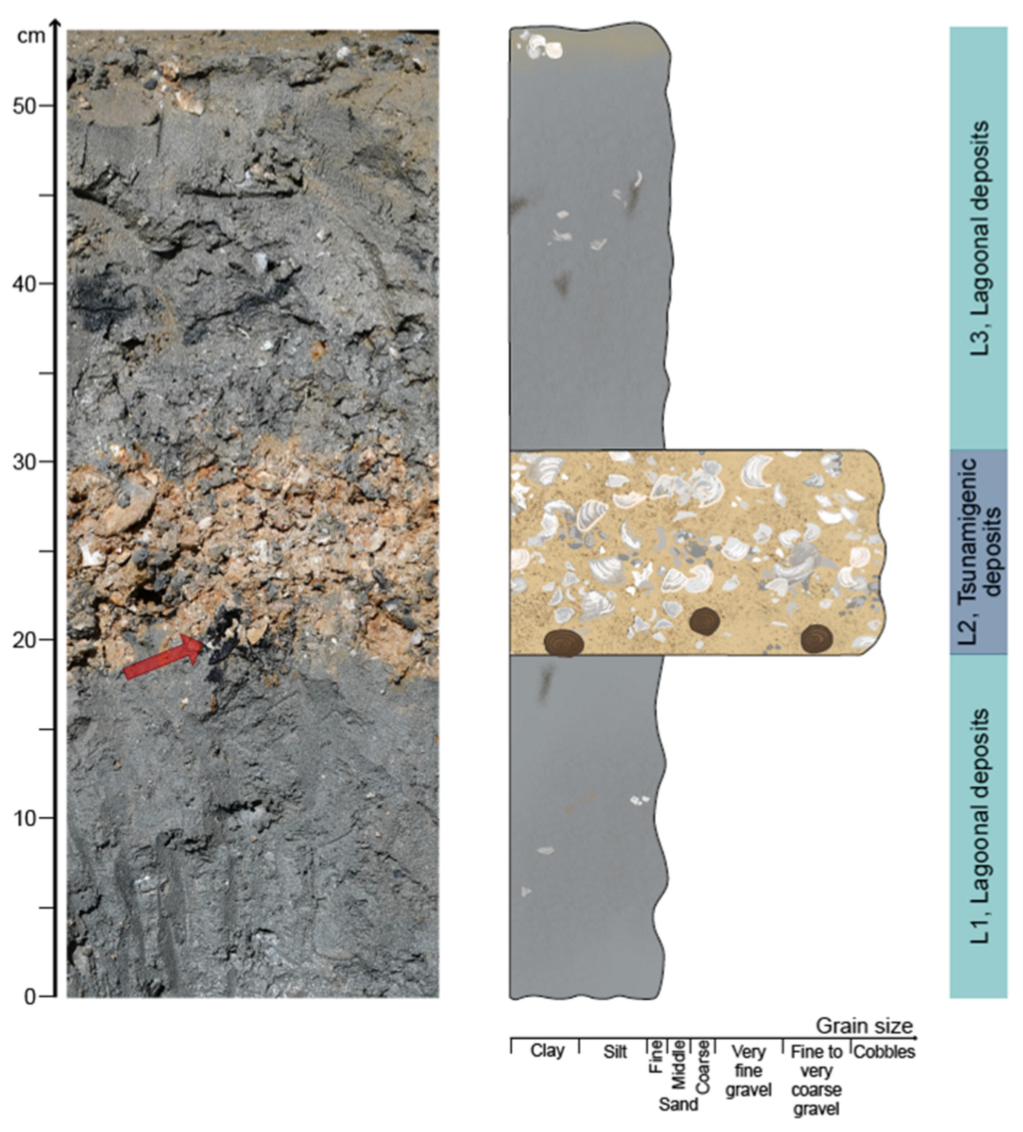
The trench excavated in the southwestern part of the Sur lagoon measures 52 cm deep and exposes three layers, which are designated here as L1 to L3 (Figure 2). The lowermost layer (L1: 0–19 cm) is composed of a gray, silty, fine sand. Abundant redoximorphic features, such as centimeter-sized black spots and some light beige vertical bioturbation structures 1 mm in diameter, are found in the trench, in addition to some small, solitary fragments of mollusk shells.
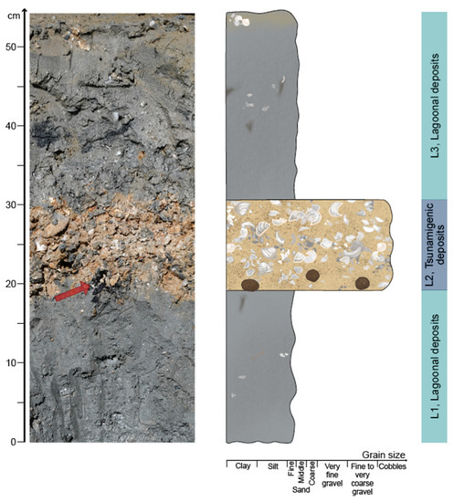
Figure 2.
Vertical sections through the tsunamigenic deposits in the Sur lagoon. Left: photo of the trench. The red arrow indicates dark-colored wood remains. Right: measured section. Brown circles represent woody axes at the base of the tsunamigenic layer L2.
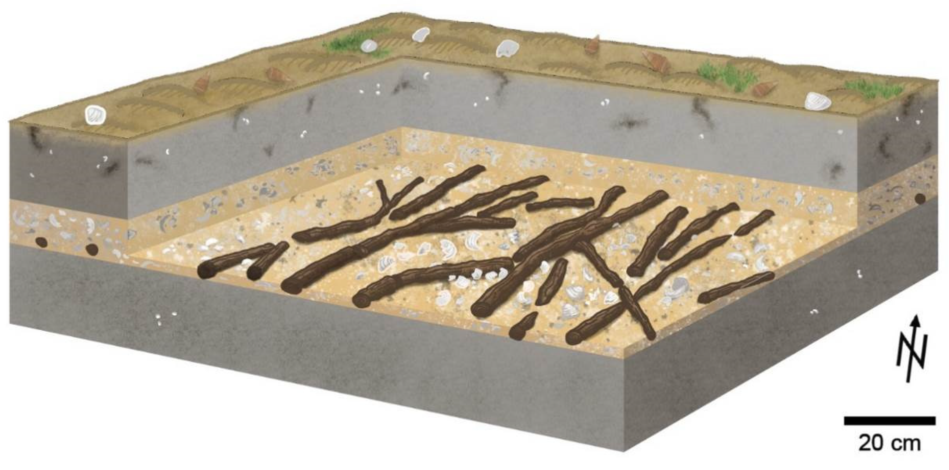
Layer L2 (19–29 cm) consists of an unsorted, clast-supported sediment with a variety of white mollusk shells, mainly articulated bivalves, and many angular shell fragments in an orange-beige, fine-to-medium sandy matrix. Woody axes occur at the base and in the lower part of L2 (Figure 2 and Figure 3). The woody axes measure up to 4 cm in diameter and up to 1.4 m long, but are commonly broken into pieces of decimeter length. They are horizontally aligned subparallel to one another and oriented NNE–SSW. The woody axes are well-preserved with macroscopic features on the bark and represent branch or stem wood. No roots were discovered.
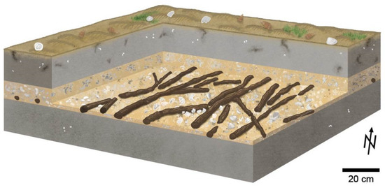
Figure 3.
Block diagram showing the subfossil woody axes in situ, aligned NNE–SSW, and embedded at the base of the tsunamigenic layer (depicted in beige) in between gray lagoonal layers. Towards the top of the block are some redoximorphic features, living Cerithidea cingulata gastropods, a few bivalve shells, and small mats of seagrass on the surface.
The sequence is capped by L3 (29–52 cm), a gray, silty fine sand with some mollusk shells, such as the gastropod Cerithidea cingulata. This layer is bioturbated by bivalves, crabs, and worms. L3 shows some centimeter-sized black spots, similar to those in L1. The color changes to light brownish gray within the upper 1 cm of the sections. Abundant mollusk shells are scattered on the surface of the lagoon; living Cerithidea cingulata gastropods are very abundant locally. Some mats of seagrass can be found.
3.2. Age Dating
Radiocarbon dating of the three bivalve shells yielded reservoir-corrected ages of 95–0 cal BP (Beta-414721), 99–0 cal BP (Beta-414722) and 115–0 cal BP (Beta-414723). Radiocarbon dating of the trench wood from L2 produced an age of 905–722 cal BP (Beta-579069) and thus characterizes the plant remains as subfossil (Table S1).
3.3. Additional Observations
Observations made in the eastern part of the lagoon at 40Q 759186 m E, 2497192 m N reveal a different sedimentological situation. Here, the subsurface is characterized by silty fine sand, comparable to layer L1 in the trench in the southwestern part of the lagoon. A shell layer equivalent to L2 was not observed. Noteworthy are cobbles, bricks, and coral fragments of decimeter size scattered on the surface. This building material apparently originates from construction in the city of Sur, as the nearest modern houses are located only 90 m away. The size of the individual clasts of this coarse surface decreases towards the center of the lagoon.
3.4. Identification of the Trench Wood
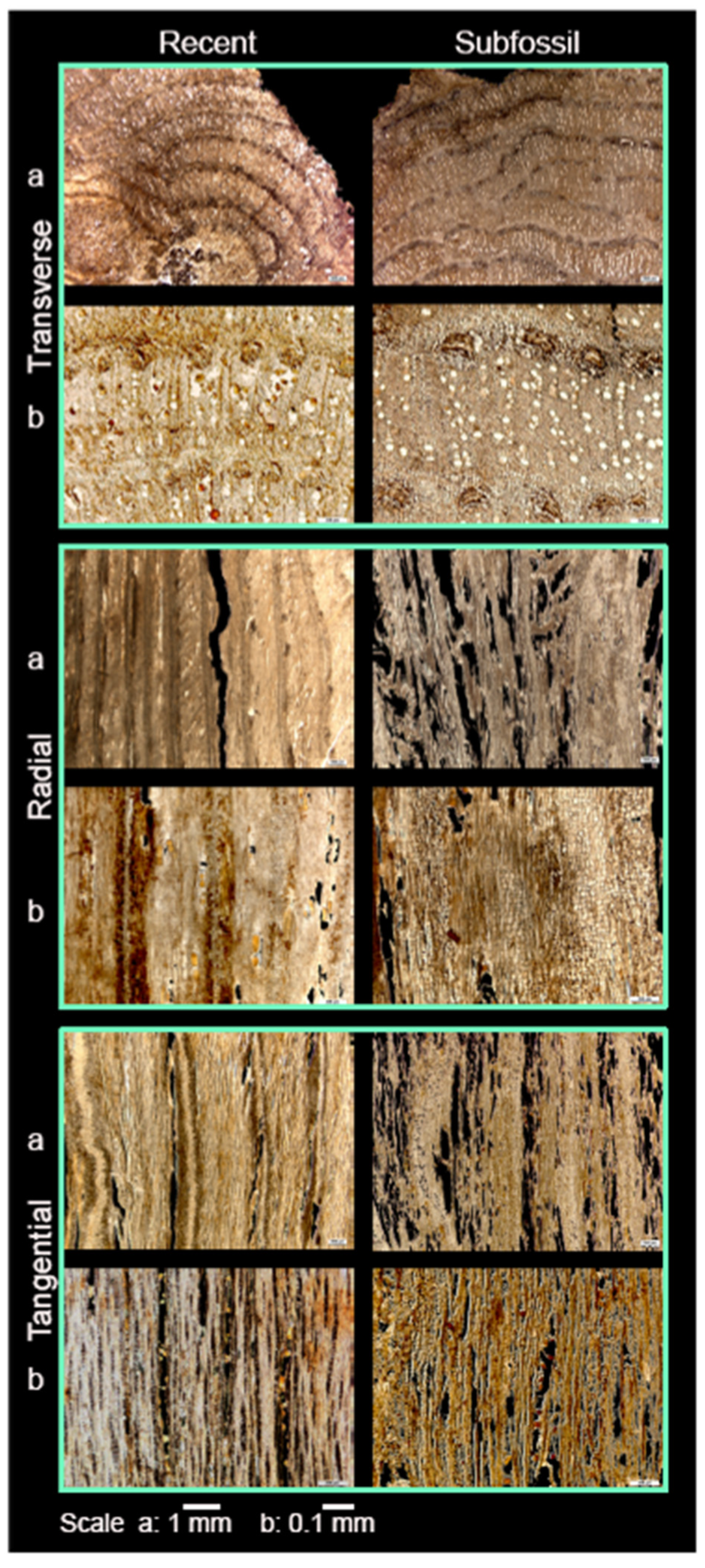
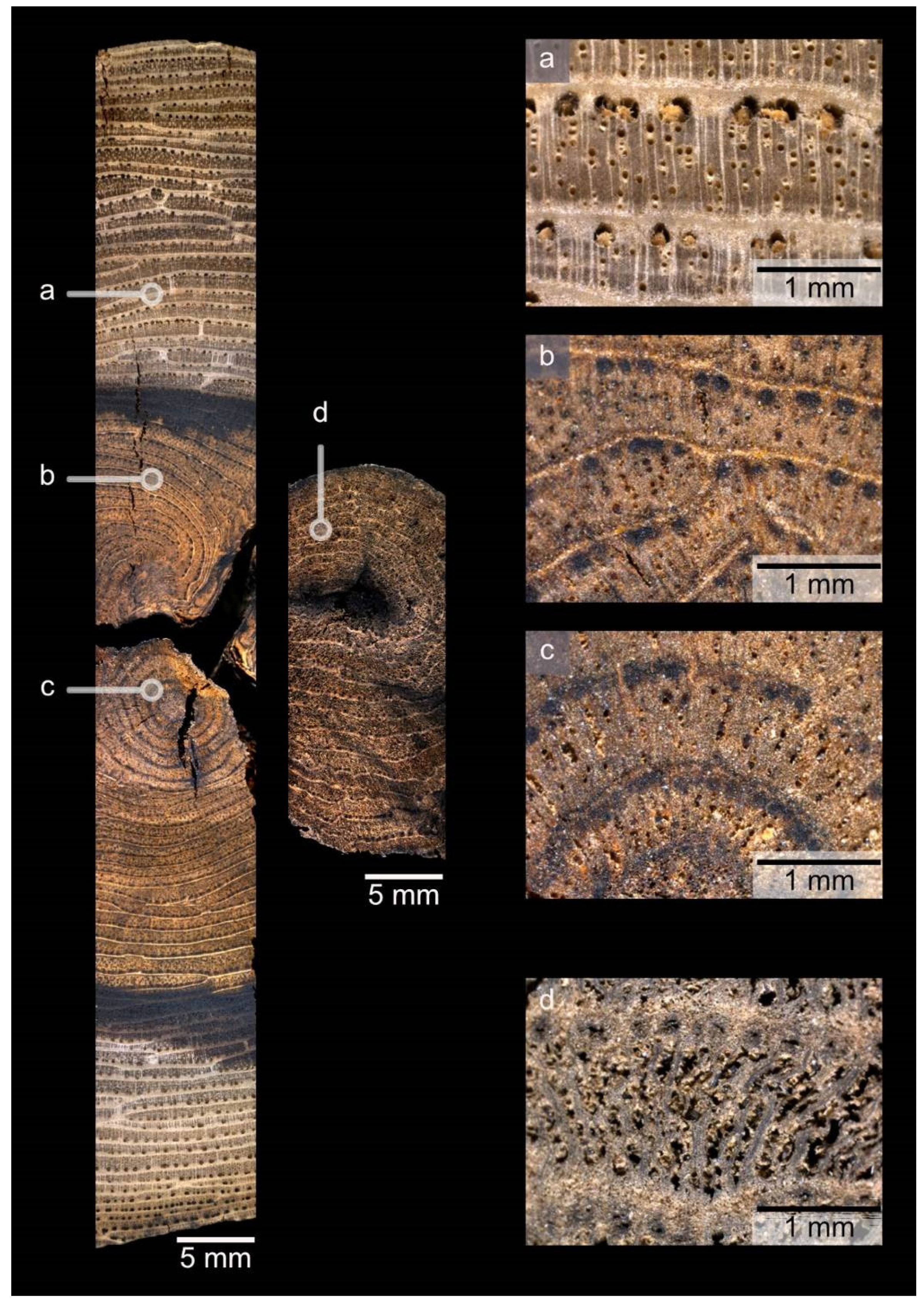
The anatomy of the trench wood is highly comparable with the recent Avicennia marina wood. Of the three planes of section, the transverse and tangential sections are the most appropriate for comparison. In the transverse section, an extremely distinctive feature found in recent Avicennia wood is a series of concentric rings which consist of alternating bands of xylem and phloem, but do not represent annual growth [31,33]. A thin band of sclerenchyma separates the rings from one another. Transverse sections of recent Avicennia wood also clearly show the occurrence of multiple, radially arranged vessel elements [24,31]. In the tangential section, another feature typically observed in recent Avicennia wood is the presence of medullary rays that are between two and five cells wide [31]. Both the recent wood of Avicennia marina and the wood from L2 show this suite of distinctive features (Figure 4 and Figure 5). Thus, based on the distinctive anatomical features of its wood, it can be concluded that the woody axes found in L2 pertain to the mangrove Avicennia.
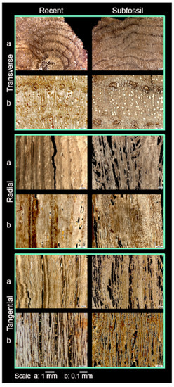
Figure 4.
Thin sections of recent Avicennia marina wood (left column) for comparison with the subfossil trench wood (right column), in the transverse, radial, and tangential sections at 1.25× (a) or 5.0× (b) magnification. Section thickness is 20 µm. The letters a and b refer to the scale bars at the bottom of the figure.
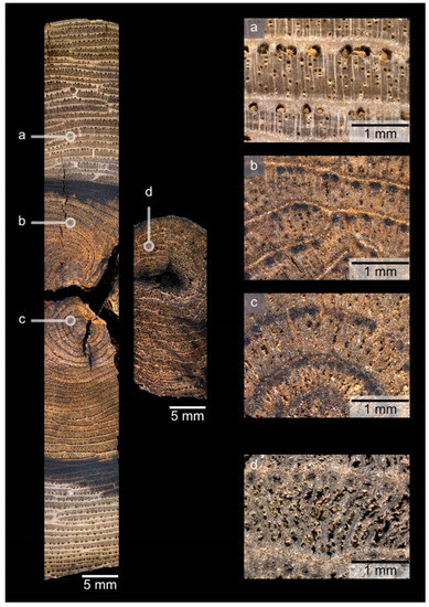
Figure 5.
Thick sections in transverse section at 1.0× magnification of recent Avicennia marina wood (left) for comparison with the subfossil trench wood (center). The right column shows details of the recent Avicennia marina wood (a–c) and the subfossil trench wood (d), all at 5.0× magnification.
4. Discussion
The northeastern Omani coastline has witnessed several tsunamigenic inundations. The relatively recent event in 1945 had a minor effect along the coastline of Oman [14]. Elsewhere, there is weak historical evidence for a tsunami around the year 1008 [34], which is supported by growing geological and sedimentological evidence of a major inundation event at this time: tsunamigenic deposits related to this event are documented in western India [35], as well as along the coastline of Iran [36] and the northern coastline of Oman [37].
Investigations along the east African coast suggest that the 1000-year-old tsunami deposits [38] may have originated from two source areas, the MSZ and the Sumatra-Andaman trench. We exclude the Sumatra-Andaman subduction zone as the source for the Sur deposits, because the tsunami in 2004 affected neither the western Indian coast nor the coastline of Iran. Thus, the source of the tsunamis in 1945 and 1008 AD can be traced back to the MSZ.
Studies by [15,29,39] describe tsunamigenic deposits in the Sur lagoon. Detailed shell taphonomy and the state of shell preservation are indicative of live transport and high energy conditions without subsequent reworking. Our sedimentological investigation of the Sur lagoon deposits is in line with the observations and interpretations made in these earlier studies. Absolute dating of the tsunamigenic layer, which we call L2, could not, however, be carried out, and an attribution to the 1945 tsunami was inferred [15]. The supposed deposition of this layer in 1945 contradicts eyewitness reports that the waves were only about 2 m high and caused only minor effects along the coastline of Oman [14]. We postulate that the bricks in the northern part of the lagoon directly behind the inhabited beach barrier accumulated as a result of the 2-m-high tsunami waves in 1945.
Our dating results challenge the earlier suggestion that the distinct shell layer L2 resulted from the tsunami of 1945. This layer contains a number of woody mangrove axes at its base, incorporated into the 10 to 20 cm-thick unsorted shell deposit. Dating of shell material from L2 remains difficult. Using shells for chronologies is problematic if their association with contemporaneous terrestrial material is not straightforward [40,41,42]. Mollusks have a reservoir effect and may contain some live endobenthic; this can lead to the incorrect dating of the specific sediment layer. An initial dating approach towards the bivalve shells of L2 in the Sur lagoon supports their association with the tsunami event in 1945, but we regard the dating results of the mollusks as incorrect due to multiple methodological challenges. Instead, we consider the wood to be the most reliable basis for age dating. As mentioned earlier, a sample taken from a woody axis found in association with L2 provides a radiocarbon date of 905–722 cal BP, characterizing the plant remains as subfossil, not modern. The orientation of the woody axes in a north–northeast direction pointing towards the MSZ suggests that this subduction zone is the most likely source area.
Regarding the sedimentological data, layer L2 points to a single tsunami event that was more extreme than the tsunami of 1945. The 14C age of the wood links the tsunamigenic deposits to the event that occurred around 1000 years ago, which is described as severe in historical [34] and geological [36,37] archives. A detailed discussion of the comparison of the impact of the tsunamis in 1945 and around the year 1000 can be found in [43].
As determined by wood anatomy, the meter-long woody axes are the remains of Avi-cennia mangroves. They offer insight into the environmental setting and details of the tsunami event that occurred roughly a millennium ago. A lack of roots means the woody axes are allochthonous or parautochthonous. While the subfossil wood can be identified as Avicennia, it could not be identified to the species level. However, it is certainly possible that the subfossil woody axes pertain to the species Avicennia marina, because this species has been known in northeastern Oman for the past few thousand years [44]. The small diameter of the woody axes, which reach a maximum diameter of 4 cm, is consistent with the size of the shrubby Avicennia marina mangrove plants that grow along the northeastern coast of Oman today.
Geological–sedimentological archives and investigations are essential to understanding tsunami dynamics and to developing good risk management and rapid emergency response. Mangrove forests reduce tsunami wave energy significantly. Similar approaches, where interdisciplinary research of geology, sedimentology, and botany prove valuable in reconstructing earthquake potential and tsunamigenic events, are presented by [28,45,46]. Recording mangrove occurrences in the geological record and monitoring them over time can, on one hand, make a major contribution to today’s coastal protection and, on the other hand, are a valuable component of environmental reconstruction and possible tsunami risk assessment with regard to archaeological questions. Hence, our understanding of past mangrove habitats, ancient coastal environments, and geological events is greatly enhanced when sedimentology, paleontology, and botany come together.
5. Conclusions
The tsunamigenic deposit in the Sur lagoon with its 25-cm-thick shell layer is reinterpreted as evidence of an extreme tsunami event that occurred almost 1000 years ago. Woody axes were newly discovered in the context of this layer. Anatomical analyses of this wood identify it as Avicennia, which attests to the presence of mangroves in the Sur lagoon one millennium ago. This tsunami event must have been more severe than the tsunami waves observed in AD 1945. A deeper understanding of the age and magnitude of tsunamigenic events will aid in understanding tsunamis generated along the Makran subduction zone. Hazard mitigation measurements along the coastline of the Arabian Sea should be reexamined today within the framework of our reinterpretation.
Supplementary Materials
The following supporting information can be downloaded at: https://www.mdpi.com/article/10.3390/f13060922/s1, Table S1: Dating results of shells and wood from the tsunamigenic layer in a trench in the Sur lagoon.
Author Contributions
Conceptualization, G.H. and V.D.; Methodology, V.D., C.T.G., S.L. and P.J.S.; Validation, G.H., C.T.G., S.L., V.D. and P.J.S.; Formal Analysis, S.L.; Investigation, G.H. and V.D.; Resources, C.T.G., P.J.S. and S.L.; Data Curation, C.T.G.; Writing—Original Draft Preparation, V.D.; Writing—Review and Editing, G.H., C.T.G., S.L. and P.J.S.; Visualization, V.D.; Supervision, G.H. and C.T.G.; Project Administration, G.H.; Funding Acquisition, G.H. All authors have read and agreed to the published version of the manuscript.
Funding
This research was funded by Deutsche Forschungsgemeinschaft, grant number HO2550/15-1. V.D. is grateful for a scholarship from the Studienstiftung des deutschen Volkes.
Data Availability Statement
Not applicable.
Acknowledgments
Dülfer, O., Shunn, K. and Lambertz, M. (University of Bonn) are thanked for providing technical assistance and equipment. This paper is a contribution to IGCP projects 639 and 725.
Conflicts of Interest
The authors declare no conflict of interest.
References
- Costa, P.J.; Andrade, C. Tsunami deposits: Present knowledge and future challenges. Sedimentology 2020, 67, 1189–1206. [Google Scholar] [CrossRef]
- Løvholt, F.; Setiadi, N.J.; Birkmann, J.; Harbitz, C.B.; Bach, C.; Fernando, N.; Kaiser, G.; Nadim, F. Tsunami risk reduction—Are we better prepared today than in 2014. IJDRR 2014, 10, 127–142. [Google Scholar]
- Tanaka, N.; Sasaki, Y.; Mowjood, M.I.M.; Jinadasa, K.B.S.N.; Homchuen, S. Coastal vegetation structures and their functions in tsunami protection: Experience of the recent Indian Ocean tsunami. Landsc. Ecol. Eng. 2007, 3, 33–45. [Google Scholar] [CrossRef]
- Alongi, D.M. Mangrove forests: Resilience, protection from tsunamis, and responses to global climate change. Estuar. Coast. Shelf Sci. 2008, 76, 1–13. [Google Scholar] [CrossRef]
- Lee, S.Y.; Primavera, J.H.; Dahdouh-Guebas, F.; McKee, K.; Bosire, J.O.; Cannicci, S.; Diele, K.; Fromard, F.; Koedam, N.; Marchand, C.; et al. Ecological role and services of tropical mangrove ecosystems: A reassessment. Glob. Ecol. Biogeogr. 2014, 23, 726–743. [Google Scholar] [CrossRef]
- Barbier, E.B. Natural barriers to natural disasters: Replanting mangroves after the tsunami. Front. Ecol. Environ. 2006, 4, 124–131. [Google Scholar] [CrossRef]
- Minoura, K.; Imamura, F.; Sugawara, D.; Kono, Y.; Iwashita, T. The 869 Jogan tsunami deposit and recurrence interval of large-scale tsunami on the Pacific coast of northeast Japan. J. Nat. Disaster Sci. 2001, 23, 83–88. [Google Scholar]
- Barnes, G.L. The search for tsunami evidence in the geological and archaeological records, with a focus on Japan. Asian Perspect. 2017, 56, 132–165. [Google Scholar] [CrossRef]
- Byrne, D.E.; Sykes, L.R.; Davis, D.M. Great thrust earthquakes and aseismic slip along the plate boundary of the Makran subduction zone. J. Geophys. Res. Solid Earth 1992, 97, 449–478. [Google Scholar] [CrossRef]
- DeMets, C.; Gordon, R.G.; Donald, F.A. Geologically current plate motions. Geophys. J. Int. 2010, 181, 1–80. [Google Scholar] [CrossRef]
- Smith, G.L.; McNeill, L.C.; Wang, K.; He, J.; Henstock, T.J. Thermal structure and megathrust seismogenic potential of the Makran subduction zone. Geophys. Res. Lett. 2013, 40, 1528–1533. [Google Scholar] [CrossRef]
- Kopp, C.; Fruehn, J.; Flueh, E.R.; Reichert, C.; Kukowski, N.; Bialas, J.; Klaeschen, D. Structure of the Makran subduction zone from wide-angle and reflection seismic data. Tectonophysics 2000, 329, 171–191. [Google Scholar] [CrossRef]
- Hoffmann, G.; Al-Yahyai, S.; Naeem, G.; Kociok, M.; Grützner, C. An Indian Ocean tsunami triggered remotely by an onshore earthquake in Balochistan. Geology 2014, 42, 883–886. [Google Scholar] [CrossRef]
- Kakar, D.M.; Naeem, G.; Usman, A.; Hasan, H.; Lohdi, H.A.; Srinivasalu, S.; Andrade, V.; Rajendran, C.P.; Beni, A.N.; Hamzeh, M.A.; et al. Elders recall an earlier tsunami on Indian Ocean shores. Eos Trans. Am. Geophys. Union 2014, 95, 485–486. [Google Scholar] [CrossRef]
- Donato, S.V.; Reinhardt, E.G.; Boyce, J.I.; Rothaus, R.; Vosmer, T. Identifying tsunami deposits using bivalve shell taphonomy. Geology 2008, 36, 199–202. [Google Scholar] [CrossRef]
- Lézine, A.M.; Saliège, J.F.; Mathieu, R.; Tagliatela, T.L.; Mery, S.; Charpentier, V.; Cleuziou, S. Mangroves of Oman during the late Holocene; climatic implications and impact on human settlements. Veg. Hist. Archaeobot. 2002, 11, 221–232. [Google Scholar] [CrossRef]
- Decker, V.; Falkenroth, M.; Lindauer, S.; Landgraf, J.; Al-Lawati, Z.; Al-Rahbi, H.; Franz, S.O.; Hoffmann, G. Collapse of Holocene mangrove ecosystems along the coastline of Oman. Quat. Res. 2021, 100, 52–76. [Google Scholar] [CrossRef]
- Lézine, A.M.; Ivory, S.J.; Braconnot, P.; Marti, O. Timing of the southward retreat of the ITCZ at the end of the Holocene Humid Period in Southern Arabia: Data-model comparison. Quat. Sci. Rev. 2017, 164, 68–76. [Google Scholar] [CrossRef]
- Deckers, K.; Döpper, S.; Schmidt, C. Vegetation, land, and wood use at the sites of Bat and Al-Khashbah in Oman (fourth–third millennium BC). Arab Arch Epig. 2019, 30, 1–14. [Google Scholar] [CrossRef]
- Tengberg, M. Les forêts de la mer. Exploitation et évolution des mangroves en Arabie orientale du Néolithique à l’époque islamique. Paléorient 2005, 31, 39–45. [Google Scholar] [CrossRef]
- Cleuziou, S.; Tosi, M. The great transformation. In In the Shadow of the Ancestors; Cleuziou, S., Tosi, M., Eds.; Al Nahda Printing Press: Muscat, Oman, 2007; pp. 61–97. [Google Scholar]
- Robert, E.M.; Koedam, N.; Beeckman, H.; Schmitz, N. A safe hydraulic architecture as wood anatomical explanation for the difference in distribution of the mangroves Avicennia and Rhizophora. Funct. Ecol. 2009, 23, 649–657. [Google Scholar] [CrossRef]
- De Deurwaerder, H. How are Anatomical and Hydraulic Features of Avicennia marina and Rhizophora mucronata Trees Influenced by Siltation? Master’s Thesis, University of Ghent, Brussels, Belgium, 2012. [Google Scholar]
- Tomlinson, P.B. The Botany of Mangroves, 2nd ed.; Cambridge University Press: New York, NY, USA, 2016; p. 432. [Google Scholar]
- Milani, A.S. Mangrove forests of the Persian Gulf and the Gulf of Oman. In Threats to Mangrove Forests: Hazards, Vulnerability, and Risk Management; Makowski, C., Finkl, C.W., Eds.; Springer: Cham, Germany, 2018; pp. 53–75. [Google Scholar]
- Le Roux, J.P.; Vargas, G. Hydraulic behavior of tsunami backflows: Insights from their modern and ancient deposits. Environ. Geol. 2005, 49, 65. [Google Scholar] [CrossRef]
- Dawson, A.G.; Stewart, I. Tsunami deposits in the geological record. Sediment. Geol. 2007, 200, 166–183. [Google Scholar] [CrossRef]
- Rhodes, B.P.; Kirby, M.E.; Jankaew, K.; Choowong, M. Evidence for a mid-Holocene tsunami deposit along the Andaman coast of Thailand preserved in a mangrove environment. Mar. Geol. 2011, 282, 255–267. [Google Scholar] [CrossRef]
- Pilarczyk, J.E.; Reinhardt, E.G.; Boyce, J.I.; Schwarcz, H.P.; Donato, S.V. Assessing surficial foraminiferal distributions as an overwash indicator in Sur Lagoon, Sultanate of Oman. Mar. Micropaleontol. 2011, 80, 62–73. [Google Scholar] [CrossRef]
- Riedelsheimer, B.; Büchl-Zimmermann, S.; Welsch, U. Schnittpräparation für die Lichtmikroskopie. In Romeis—Mikroskopische Technik, 19th ed.; Mulisch, M., Welsch, U., Eds.; Springer: Berlin/Heidelberg, Germany, 2015; pp. 99–120. [Google Scholar]
- Jagiella, C.; Kürschner, H. Atlas der Hölzer Saudi Arabiens. Die Holzanatomie der Wichtigsten Bäume und Sträucher Arabiens mit Einem Holzanatomischen Bestimmungsschlüssel; Beihefte zum TAVO; Ludwig Reichert: Wiesbaden, Germany, 1987; Volume 20, p. 176. [Google Scholar]
- Reimer, P.J.; Bard, E.; Bayliss, A.; Beck, J.W.; Blackwell, P.G.; Ramsey, C.B.; Buck, C.E.; Buck, C.E.; Cheng, H.; Edwards, R.L.; et al. IntCal13 and Marine13 Radiocarbon Age Calibration Curves 0–50,000 Years cal BP. Radiocarbon 2013, 55, 1869–1887. [Google Scholar] [CrossRef]
- Schmitz, N.; Verheyden, A.; Kairo, J.G.; Beeckman, H.; Koedam, N. Successive cambia development in Avicennia marina (Forskk.) Vierh. is not climatically driven in the seasonal climate at Gazi Bay, Kenya. Dendrochronologia 2007, 25, 87–96. [Google Scholar] [CrossRef]
- Ambraseys, N.N.; Melville, C.P. A History of Persian Earthquakes; Cambridge University Press: Cambridge, UK, 1982; p. 219. [Google Scholar]
- Prizomwala, S.P.; Gandhi, D.; Bhatt, N.; Winkler, W.; Kumar, M.R.; Makwana, N.; Bhatt, N. Geological evidence for AD 1008 tsunami along the Kachchh coast, Western India: Implications for hazard along the Makran Subduction Zone. Sci. Rep. 2018, 8, 16816. [Google Scholar] [CrossRef] [PubMed]
- Shah-hosseini, M.; Morhange, C.; Beni, A.N.; Marriner, N.; Lahijani, H.; Hamzeh, M.; Sabatier, F. Coastal boulders as evidence for high-energy waves on the Iranian coast of Makran. Mar. Geol. 2011, 290, 17–28. [Google Scholar] [CrossRef]
- Hoffmann, G.; Grützner, C.; Schneider, B.; Preusser, F.; Reicherter, K. Large Holocene tsunamis in the northern Arabian Sea. Mar. Geol. 2020, 419, 106068. [Google Scholar] [CrossRef]
- Maselli, V.; Oppo, D.; Moore, A.L.; Gusman, A.R.; Mtelela, C.; Iacopini, D.; Taviani, M.; Mjema, E.; Mulaya, E.; Che, M.; et al. A 1000-yr-old tsunami in the Indian Ocean points to greater risk for East Africa. Geology 2020, 48, 808–813. [Google Scholar] [CrossRef]
- Donato, S.V.; Reinhardt, E.G.; Boyce, J.I.; Pilarczyk, J.E.; Jupp, B.P. Particle-size distribution of inferred tsunami deposits in Sur Lagoon, Sultanate of Oman. Mar. Geol. 2009, 257, 54–64. [Google Scholar] [CrossRef]
- Bezerra, F.H.R.; Vita-Finzi, C.; Lima-Filho, F.P. The use of marine shells for radiocarbon dating of coastal deposits. Rev. Bras. Geociências 2000, 30, 211–213. [Google Scholar] [CrossRef]
- Culleton, B.J.; Kennett, D.J.; Ingram, B.L.; Erlandson, J.M.; Southon, J.R. Intrashell radiocarbon variability in marine mollusks. Radiocarbon 2006, 48, 387–400. [Google Scholar] [CrossRef]
- Gillespie, R.; Polach, H.A. The suitability of marine shells for radiocarbon dating of Australian prehistory. In Radiocarbon Dating; Berger, R., Suess, H.E., Eds.; University of California Press: Berkeley, CA, USA, 2020; pp. 404–421. [Google Scholar]
- Hoffmann, G.; Rupprechter, M.; Al Balishi, N.; Grützner, C.; Reicherter, K. The impact of the 1945 Makran tsunami along the coastlines of the Arabian Sea (Northern Indian Ocean)—A review. Z. Für Geomorphol. 2013, 57 (Suppl. 4), 257–277. [Google Scholar] [CrossRef]
- Lézine, A.M. Timing of vegetation changes at the end of the Holocene Humid Period in desert areas at the northern edge of the Atlantic and Indian monsoon systems. Comptes Rendus Geosci. 2009, 341, 750–759. [Google Scholar] [CrossRef]
- Cisternas, M.; Atwater, B.F.; Torrejon, F.; Sawai, Y.; Machuca, G.; Lagos, M.; Eipert, A.; Youlton, C.; Salgado, I.; Kamataki, T.; et al. Predecessors of the giant 1960 Chile earthquake. Nature 2005, 437, 404–407. [Google Scholar] [CrossRef]
- Monecke, K.; Finger, W.; Klarer, D.; Kongko, W.; McAdoo, B.G.; Moore, A.L.; Sudrajat, S.U. A 1000-year sediment record of tsunami recurrence in northern Sumatra. Nature 2008, 455, 1232–1234. [Google Scholar] [CrossRef]
Publisher’s Note: MDPI stays neutral with regard to jurisdictional claims in published maps and institutional affiliations. |
© 2022 by the authors. Licensee MDPI, Basel, Switzerland. This article is an open access article distributed under the terms and conditions of the Creative Commons Attribution (CC BY) license (https://creativecommons.org/licenses/by/4.0/).

