
About Tree Height Measurement: Theoretical and Practical Issues for Uncertainty Quantification and Mapping


Abstract
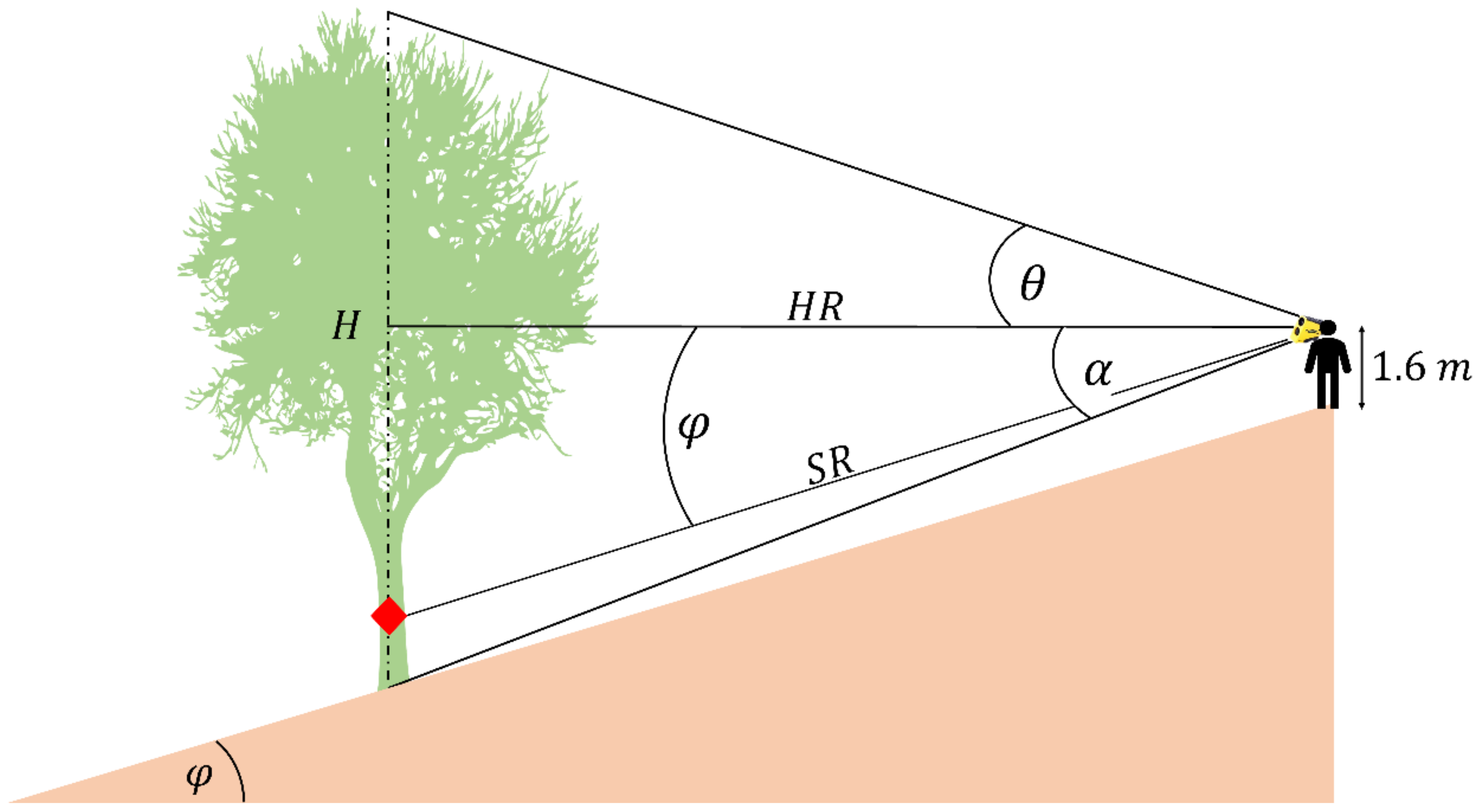
:1. Introduction
2. Materials and Methods
2.1. Available Data
2.1.1. Experimental Design of Field Surveys
2.1.2. Geographical Data
2.2. Data Processing
2.2.1. Uncertainty Modelling
2.2.2. Mapping Tree Height Uncertainty at the Global Scale
3. Results
3.1. Uncertainty Modelling
3.2. Mapping Forest Height Uncertainty at the Global Scale
4. Conclusions
Author Contributions
Funding
Data Availability Statement
Acknowledgments
Conflicts of Interest
References
- Segura, M.; Kanninen, M. Allometric Models for Tree Volume and Total Aboveground Biomass in a Tropical Humid Forest in Costa Rica. Biotropica J. Biol. Conserv. 2005, 37, 2–8. [Google Scholar] [CrossRef]
- Laurin, G.V.; Ding, J.; Disney, M.; Bartholomeus, H.; Herold, M.; Papale, D.; Valentini, R. Tree Height in Tropical Forest as Measured by Different Ground, Proximal, and Remote Sensing Instruments, and Impacts on above Ground Biomass Estimates. Int. J. Appl. Earth Obs. Geoinf. 2019, 82, 101899. [Google Scholar]
- Hao, Z.; Zhang, J.; Song, B.; Ye, J.; Li, B. Vertical Structure and Spatial Associations of Dominant Tree Species in an Old-Growth Temperate Forest. For. Ecol. Manag. 2007, 252, 1–11. [Google Scholar] [CrossRef]
- Song, B.; Chen, J.; Desander, P.V.; Reed, D.D.; Bradshaw, G.A.; Franklin, J.F. Modeling Canopy Structure and Heterogeneity across Scales: From Crowns to Canopy. For. Ecol. Manag. 1997, 96, 217–229. [Google Scholar] [CrossRef]
- Spies, T.A. Forest Structure: A Key to the Ecosystem. Northwest Sci. 1998, 72, 34–36. [Google Scholar]
- Skovsgaard, J.P.; Johannsen, V.K.; Vanclay, J.K. Accuracy and Precision of Two Laser Dendrometers. For. Int. J. For. Res. 1998, 71, 131–139. [Google Scholar] [CrossRef] [Green Version]
- Ochal, W.; Socha, J.; Pierzchalski, M. The Effect of the Calculation Method, Plot Size, and Stand Density on the Accuracy of Top Height Estimation in Norway Spruce Stands. Iforest-Biogeosciences For. 2017, 10, 498. [Google Scholar] [CrossRef] [Green Version]
- Momo, E.J.; De Petris, S.; Sarvia, F.; Borgogno-Mondino, E. Addressing Management Practices of Private Forests by Remote Sensing and Open Data: A Tentative Procedure. Remote Sens. Appl. Soc. Environ. 2021, 23, 100563. [Google Scholar] [CrossRef]
- Lund, H.G. When Is a Forest Not a Forest? J. For. 2002, 100, 21–28. [Google Scholar]
- Sillett, S.C.; Van Pelt, R.; Koch, G.W.; Ambrose, A.R.; Carroll, A.L.; Antoine, M.E.; Mifsud, B.M. Increasing Wood Production through Old Age in Tall Trees. For. Ecol. Manag. 2010, 259, 976–994. [Google Scholar] [CrossRef]
- Hanewinkel, M.; Hummel, S.; Albrecht, A. Assessing Natural Hazards in Forestry for Risk Management: A Review. Eur. J. For. Res. 2011, 130, 329–351. [Google Scholar] [CrossRef]
- Martins, A.C.; Willig, M.R.; Presley, S.J.; Marinho-Filho, J. Effects of Forest Height and Vertical Complexity on Abundance and Biodiversity of Bats in Amazonia. For. Ecol. Manag. 2017, 391, 427–435. [Google Scholar] [CrossRef]
- Bohn, F.J.; Huth, A. The Importance of Forest Structure to Biodiversity–Productivity Relationships. R. Soc. Open Sci. 2017, 4, 160521. [Google Scholar] [CrossRef] [PubMed] [Green Version]
- Purves, D.W.; Lichstein, J.W.; Strigul, N.; Pacala, S.W. Predicting and Understanding Forest Dynamics Using a Simple Tractable Model. Proc. Natl. Acad. Sci. USA 2008, 105, 17018–17022. [Google Scholar] [CrossRef] [Green Version]
- Pan, Y.; Birdsey, R.A.; Fang, J.; Houghton, R.; Kauppi, P.E.; Kurz, W.A.; Phillips, O.L.; Shvidenko, A.; Lewis, S.L.; Canadell, J.G. A Large and Persistent Carbon Sink in the World’s Forests. Science 2011, 333, 988–993. [Google Scholar] [CrossRef] [PubMed] [Green Version]
- Tavoni, M.; Sohngen, B.; Bosetti, V. Forestry and the Carbon Market Response to Stabilize Climate. Energy Policy 2007, 35, 5346–5353. [Google Scholar] [CrossRef] [Green Version]
- Ter-Mikaelian, M.T.; Korzukhin, M.D. Biomass Equations for Sixty-Five North American Tree Species. For. Ecol. Manag. 1997, 97, 1–24. [Google Scholar] [CrossRef] [Green Version]
- Zianis, D.; Muukkonen, P.; Mäkipää, R.; Mencuccini, M. Biomass and Stem Volume Equations for Tree Species in Europe; The Finnish Society of Forest Science: Helsinki, Finland, 2005. [Google Scholar]
- Neumann, M.; Moreno, A.; Mues, V.; Härkönen, S.; Mura, M.; Bouriaud, O.; Lang, M.; Achten, W.M.; Thivolle-Cazat, A.; Bronisz, K. Comparison of Carbon Estimation Methods for European Forests. For. Ecol. Manag. 2016, 361, 397–420. [Google Scholar] [CrossRef]
- De Petris, S.; Sarvia, F.; Borgogno-Mondino, E. RPAS-Based Photogrammetry to Support Tree Stability Assessment: Longing for Precision Arboriculture. Urban For. Urban Green. 2020, 55, 126862. [Google Scholar] [CrossRef]
- De Petris, S.; Berretti, R.; Sarvia, F.; Borgogno Mondino, E. When a Definition Makes the Difference: Operative Issues about Tree Height Measures from RPAS-Derived CHMs. iForest-Biogeosci. For. 2020, 13, 404. [Google Scholar] [CrossRef]
- Yin, D.; Wang, L. How to Assess the Accuracy of the Individual Tree-Based Forest Inventory Derived from Remotely Sensed Data: A Review. Int. J. Remote Sens. 2016, 37, 4521–4553. [Google Scholar] [CrossRef]
- West, P.W.; West, P.W. Tree and Forest Measurement; Springer: Cham, Switzerland, 2009. [Google Scholar]
- van Laar, A.; Akça, A. Forest Mensuration (Managing Forest Ecosystems), 2nd ed.; Completely Rev. and Supplemented; Springer: Dordrecht, The Netherlands, 2007; ISBN 978-1-4020-5990-2. [Google Scholar]
- Larsen, D.R.; Hann, D.W.; Stearns-Smith, S.C. Accuracy and Precision of the Tangent Method of Measuring Tree Height. West. J. Appl. For. 1987, 2, 26–28. [Google Scholar] [CrossRef]
- Stereńczak, K.; Mielcarek, M.; Wertz, B.; Bronisz, K.; Zajączkowski, G.; Jagodziński, A.M.; Ochał, W.; Skorupski, M. Factors Influencing the Accuracy of Ground-Based Tree-Height Measurements for Major European Tree Species. J. Environ. Manag. 2019, 231, 1284–1292. [Google Scholar] [CrossRef]
- Köhl, M.; Magnussen, S.S.; Marchetti, M. Sampling Methods, Remote Sensing and GIS Multiresource Forest Inventory; Springer Science & Business Media: Berlin/Heidelberg, Germany, 2006. [Google Scholar]
- Vogt, J.M.; Fischer, B.C. A Protocol for Citizen Science Monitoring of Recently-Planted Urban Trees. In Urban Forests, Ecosystem Services and Management; Blum, J., Ed.; Apple Academic Press: New York, NY, USA, 2017; pp. 153–186. [Google Scholar]
- Mascaro, J.; Detto, M.; Asner, G.P.; Muller-Landau, H.C. Evaluating Uncertainty in Mapping Forest Carbon with Airborne LiDAR. Remote Sens. Environ. 2011, 115, 3770–3774. [Google Scholar] [CrossRef]
- Clark, N.A.; Wynne, R.H.; Schmoldt, D.L. A Review of Past Research on Dendrometers. For. Sci. 2000, 46, 570–576. [Google Scholar]
- Pariyar, S.; Mandal, R.A. Comparative Tree Height Measurement Using Different Instrument. Int. J. Ecol. Environ. Sci. 2019, 1, 12–17. [Google Scholar]
- Williams, M.S.; Bechtold, W.A.; LaBau, V.J. Five Instruments for Measuring Tree Height: An Evaluation. South. J. Appl. For. 1994, 18, 76–82. [Google Scholar] [CrossRef] [Green Version]
- Wing, M.G.; Solmie, D.; Kellogg, L. Comparing Digital Range Finders for Forestry Applications. J. For. 2004, 102, 16–20. [Google Scholar]
- Saliu, I.S.; Satyanarayana, B.; Fisol, M.A.B.; Wolswijk, G.; Decannière, C.; Lucas, R.; Otero, V.; Dahdouh-Guebas, F. An Accuracy Analysis of Mangrove Tree Height Mensuration Using Forestry Techniques, Hypsometers and UAVs. Estuarine Coast. Shelf Sci. 2021, 248, 106971. [Google Scholar] [CrossRef]
- Vasilescu, M.M. Standard Error of Tree Height Using Vertex III. Bull. Transilv. Univ. Brasov. For. Wood Ind. Agric. Food Eng. Ser. II 2013, 6, 75. [Google Scholar]
- Schreuder, H.T.; Gregoire, T.G.; Wood, G.B. Sampling Methods for Multiresource Forest Inventory; John Wiley & Sons: New York, NY, USA, 1993. [Google Scholar]
- Ku, H.H. Notes on the Use of Propagation of Error Formulas. J. Res. Natl. Bur. Stand. 1966, 70, 263–273. [Google Scholar] [CrossRef]
- Laser Technology Inc TruPulse 200 User’s Manual 2018. Available online: https://lasertech.com/wp-content/uploads/LTI-TruPulse-200.6.pdf (accessed on 5 June 2022).
- Simard, M.; Pinto, N.; Fisher, J.B.; Baccini, A. Mapping Forest Canopy Height Globally with Spaceborne Lidar. J. Geophys. Res. Biogeosciences 2011, 116. [Google Scholar] [CrossRef] [Green Version]
- Hayashi, M.; Saigusa, N.; Oguma, H.; Yamagata, Y. Forest Canopy Height Estimation Using ICESat/GLAS Data and Error Factor Analysis in Hokkaido, Japan. ISPRS J. Photogramm. Remote Sens. 2013, 81, 12–18. [Google Scholar] [CrossRef]
- Hastings, D.A.; Dunbar, P. Development & Assessment of the Global Land One-Km Base Elevation Digital Elevation Model (GLOBE). Group 1998, 4, 218–221. [Google Scholar]
- Dinerstein, E.; Olson, D.; Joshi, A.; Vynne, C.; Burgess, N.D.; Wikramanayake, E.; Hahn, N.; Palminteri, S.; Hedao, P.; Noss, R. An Ecoregion-Based Approach to Protecting Half the Terrestrial Realm. BioScience 2017, 67, 534–545. [Google Scholar] [CrossRef] [PubMed]
- Ojoatre, S.; Zhang, C.; Hussin, Y.A.; Kloosterman, H.E.; Ismail, M.H. Assessing the Uncertainty of Tree Height and Aboveground Biomass from Terrestrial Laser Scanner and Hypsometer Using Airborne LiDAR Data in Tropical Rainforests. IEEE J. Sel. Top. Appl. Earth Obs. Remote Sens. 2019, 12, 4149–4159. [Google Scholar] [CrossRef] [Green Version]
- Lira, I. Evaluating the Measurement Uncertainty: Fundamentals and Practical Guidance; CRC Press: Boca Raton, FL, USA, 2002. [Google Scholar]
- Muelaner, J.E.; Wang, Z.; Jamshidi, J.; Maropoulos, P.G.; Mileham, A.R.; Hughes, E.B.; Forbes, A.B. Study of the Uncertainty of Angle Measurement for a Rotary-Laser Automatic Theodolite (R-LAT). Proc. Inst. Mech. Eng. Part B J. Eng. Manuf. 2009, 223, 217–229. [Google Scholar] [CrossRef] [Green Version]
- Gorelick, N.; Hancher, M.; Dixon, M.; Ilyushchenko, S.; Thau, D.; Moore, R. Google Earth Engine: Planetary-Scale Geospatial Analysis for Everyone. Remote Sens. Environ. 2017, 202, 18–27. [Google Scholar] [CrossRef]
- Bragg, D.C. The Sine Method as a More Accurate Height Predictor for Hardwoods; e-Gen. Tech. Rep. SRS–101; U.S. Department of Agriculture, Forest Service, Southern Research Station: 23-33. [CD-ROM]; U.S. Department of Agriculture: Washington, DC, USA, 2007. [Google Scholar]
- Husch, B.; Beers, T.W.; Kershaw, J.A., Jr. Forest Mensuration; John Wiley & Sons: Hoboken, NJ, USA, 2002. [Google Scholar]
- Korning, J.; Thomsen, K. A New Method for Measuring Tree Height in Tropical Rain Forest. J. Veg. Sci. 1994, 5, 139–140. [Google Scholar] [CrossRef]
- Božić, M.; Čavlović, J.; Lukić, N.; Teslak, K.; Kos, D. Efficiency of Ultrasonic Vertex III Hypsometer Compared to the Most Commonly Used Hypsometers in Croatian Forestry. Croat. J. For. Eng. J. Theory Appl. For. Eng. 2005, 26, 91–99. [Google Scholar]
- Hyyppä, J.; Pyysalo, U.; Hyyppä, H.; Samberg, A. Elevation Accuracy of Laser Scanning-Derived Digital Terrain and Target Models in Forest Environment. In Proceedings of the Proceedings of EARSeL-SIG-Workshop LIDAR, Dresden, Germany, 23–26 October 2016; pp. 16–17. [Google Scholar]


| Biomes | Code (ID) |
|---|---|
| Tropical and Subtropical Moist broadleaf Forests | B1 |
| Montane Grassland and Shrublands | B10 |
| Tundra | B11 |
| Mediterranean Forests, Woodlands, and Scrub | B12 |
| Deserts and Xeric Shrublands | B13 |
| Mangroves | B14 |
| Tropical and Subtropical Dry broadleaf Forests | B2 |
| Tropical and Subtropical Coniferous Forests | B3 |
| Temperate Broadleaf and Mixed Forests | B4 |
| Temperate Conifer Forests | B5 |
| Boreal Forests or Taiga | B6 |
| Tropical and Subtropical Grassland, Savannas, and Shrublands | B7 |
| Temperate Grassland, Savannas, and Shrublands | B8 |
| Flooded Grassland and Savannas | B9 |
| Partial Derivatives |
|---|
| Factor | Formula |
|---|---|
| Sum of weights | |
| Slant Range | |
| Terrain slope | |
| Angle pointing tree bottom | |
| Angle pointing tree apex | |
| Mixed term considering and correlation | |
| Mixed term considering and correlation |
| Coefficient | Value | Standard Error | t | p-Value |
|---|---|---|---|---|
| a | 0.1871 | 0.0031 | 3.25 | 0.0051 |
| b | −1.0841 | 0.0874 | 3.92 | 0.0064 |
| c | 0.0178 | 0.0035 | 3.22 | 0.0094 |
| d | −0.4156 | 0.1232 | 3.65 | 0.0053 |
Publisher’s Note: MDPI stays neutral with regard to jurisdictional claims in published maps and institutional affiliations. |
© 2022 by the authors. Licensee MDPI, Basel, Switzerland. This article is an open access article distributed under the terms and conditions of the Creative Commons Attribution (CC BY) license (https://creativecommons.org/licenses/by/4.0/).
Share and Cite
De Petris, S.; Sarvia, F.; Borgogno-Mondino, E. About Tree Height Measurement: Theoretical and Practical Issues for Uncertainty Quantification and Mapping. Forests 2022, 13, 969. https://doi.org/10.3390/f13070969
De Petris S, Sarvia F, Borgogno-Mondino E. About Tree Height Measurement: Theoretical and Practical Issues for Uncertainty Quantification and Mapping. Forests. 2022; 13(7):969. https://doi.org/10.3390/f13070969
Chicago/Turabian StyleDe Petris, Samuele, Filippo Sarvia, and Enrico Borgogno-Mondino. 2022. "About Tree Height Measurement: Theoretical and Practical Issues for Uncertainty Quantification and Mapping" Forests 13, no. 7: 969. https://doi.org/10.3390/f13070969
APA StyleDe Petris, S., Sarvia, F., & Borgogno-Mondino, E. (2022). About Tree Height Measurement: Theoretical and Practical Issues for Uncertainty Quantification and Mapping. Forests, 13(7), 969. https://doi.org/10.3390/f13070969