
Drivers and Trends in the Size and Severity of Forest Fires Endangering WUI Areas: A Regional Case Study

 ,
,  , ,
, ,  and
and
Abstract
:1. Introduction
2. Material and Methods
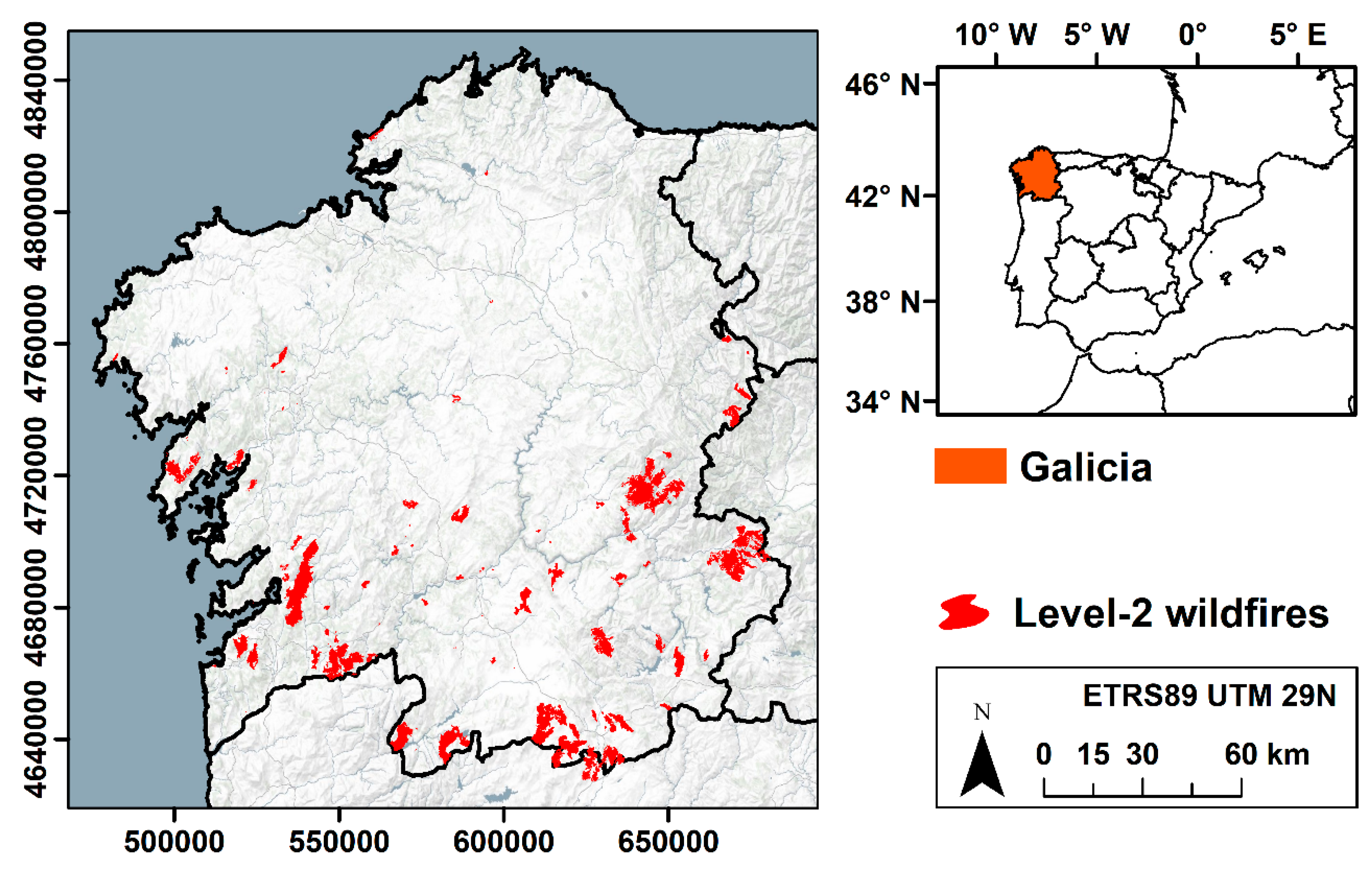
2.1. Study Area
2.2. Datasets
2.3. Data Analysis
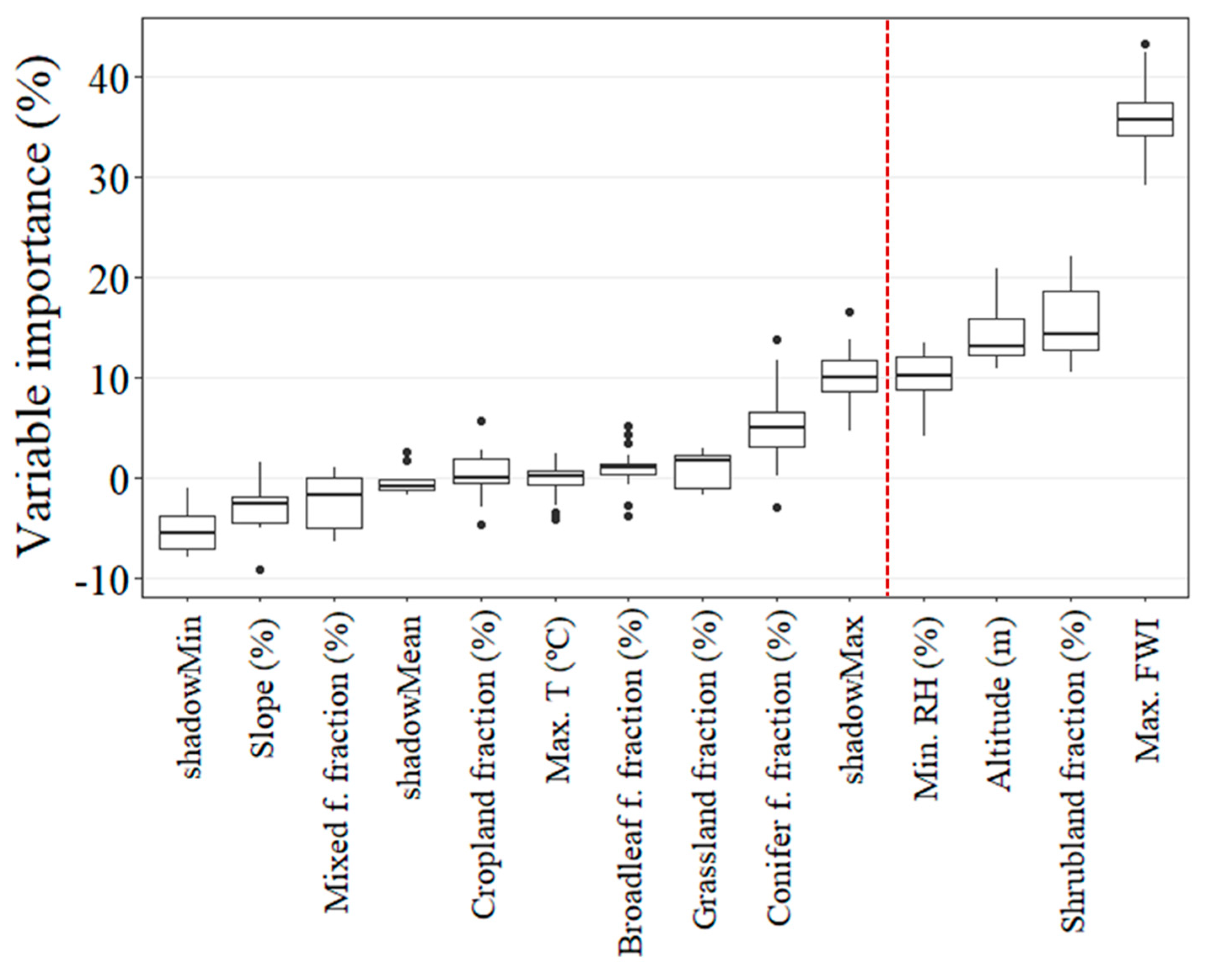
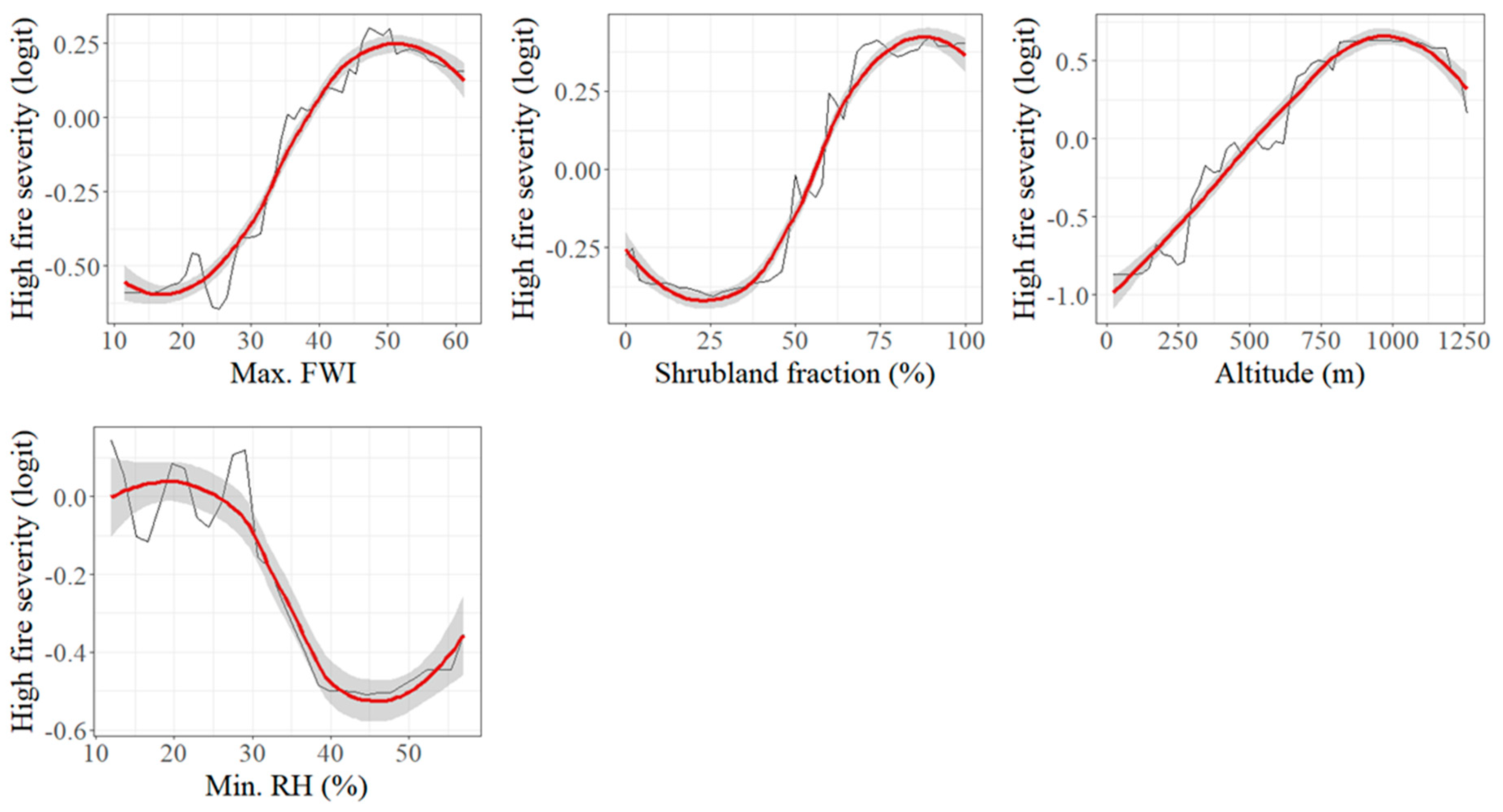
3. Results
4. Discussion
5. Conclusions
Author Contributions
Funding
Institutional Review Board Statement
Informed Consent Statement
Data Availability Statement
Acknowledgments
Conflicts of Interest
References
- Bento-Gonçalves, A.; Vieira, A. Forest fires in the wildland-urban interface: Key concepts and evaluation methodologies. Sci. Total Environ. 2020, 707, 135592. [Google Scholar] [CrossRef]
- Fernandez-Anez, N.; Krasovskiy, A.; Müller, M.; Vacik, H.; Baetens, J.; Hukić, E.; Kapovic Solomun, M.; Atanassova, I.; Glushkova, M.; Bogunović, I.; et al. Current Wildland Fire Patterns and Challenges in Europe: A Synthesis of National Perspectives. Air Soil Water Res. 2021, 14, 11786221211028184. [Google Scholar] [CrossRef]
- Yadav, K.; Escobedo, F.J.; Thomas, A.S.; Johnson, N.G. Increasing forest fires and changing sociodemographics in communities across California, USA. Int. J. Disaster Risk Reduct. 2023, 98, 104065. [Google Scholar] [CrossRef]
- Harrison, S.P.; Prentice, I.C.; Bloomfield, K.J.; Dong, N.; Forkel, M.; Forrest, M.; Ningthoujam, R.K.; Pellegrini, A.; Shen, Y.; Baudena, M. Understanding and modelling forest fire regimes: An ecological perspective. Environ. Res. Lett. 2021, 16, 125008. [Google Scholar] [CrossRef]
- Ascoli, D.; Moris, J.V.; Marco, M.; Lorenzo, S. Land use change towards forests and wooded land correlates with large and frequent forest fires in Italy. Ann. Silvic. Res. 2021, 46, 177–188. [Google Scholar]
- Vilar, L.; Herrera, S.; Tafur-García, E.; Yebra, M.; Martínez-Vega, J.; Echavarría, P.; Martín, M.P. Modelling forest fire occurrence at regional scale from land use/cover and climate change scenarios. Environ. Model. Softw. 2021, 145, 105200. [Google Scholar] [CrossRef]
- Montiel-Molina, C.; Vilar, L.; Romão-Sequeira, C.; Karlsson, O.; Galiana-Martín, L.; Madrazo-García de Lomana, G.; Palacios-Estremera, M.T. Have historical land use/land cover changes triggered a fire regime shift in central Spain? Fire 2019, 2, 44. [Google Scholar] [CrossRef]
- de Diego, J.; Fernández, M.; Rúa, A.; Kline, J.D. Spatializing and temporalizing socioeconomic determinants of forest fires in Galicia (Spain). 2022. preprint. [Google Scholar]
- MacDonald, D.; Crabtree, J.R.; Wiesinger, G.; Dax, T.; Stamou, N.; Fleury, P.; Lazpita, J.G.; Gibon, A. Agricultural abandonment in mountain areas of Europe: Environmental consequences and policy response. J. Environ. Manag. 2000, 59, 47–69. [Google Scholar] [CrossRef]
- Moreira, F.; Viedma, O.; Arianoutsou, M.; Curt, T.; Koutsias, N.; Rigolot, E.; Barbati, A.; Corona, P.; Vaz, P.; Xanthopoulos, G. Landscape–forest fire interactions in southern Europe: Implications for landscape management. J. Environ. Manag. 2011, 92, 2389–2402. [Google Scholar] [CrossRef]
- Balmes, J.R. The changing nature of forest fires: Impacts on the health of the public. Clin. Chest Med. 2020, 41, 771–776. [Google Scholar] [CrossRef]
- Borchers Arriagada, N.; Bowman, D.M.J.S.; Palmer, A.J.; Johnston, F.H. Climate change, forest fires, heatwaves and health impacts in Australia. In Extreme Weather Events and Human Health: International Case Studies; Springer: Cham, Switzerland, 2020; pp. 99–116. [Google Scholar]
- Nunes, A.N.; Figueiredo, A.; Pinto, C.; Lourenço, L. Assessing Wildfire Hazard in the Wildland–Urban Interfaces (WUIs) of Central Portugal. Forests 2023, 14, 1106. [Google Scholar] [CrossRef]
- Palaiologou, P.; Ager, A.A.; Nielsen-Pincus, M.; Evers, C.R.; Day, M.A. Social vulnerability to large forest fires in the western USA. Landsc. Urban Plan. 2019, 189, 99–116. [Google Scholar] [CrossRef]
- Giorgi, F.; Lionello, P. Climate change projections for the Mediterranean region. Glob. Planet. Change 2008, 63, 90–104. [Google Scholar] [CrossRef]
- Jones, M.W.; Smith, A.; Betts, R.; Canadell, J.G.; Prentice, I.C.; Le Quéré, C. Climate change increases the risk of forest fires. Sci. Rev. 2020, 116, 117. [Google Scholar]
- Rodrigues, M.; Camprubí, À.C.; Balaguer-Romano, R.; Megía, C.J.C.; Castañares, F.; Ruffault, J.; Fernandes, P.M.; de Dios, V.R. Drivers and implications of the extreme 2022 forest fire season in Southwest Europe. Sci. Total Environ. 2023, 859, 160320. [Google Scholar] [CrossRef] [PubMed]
- Da Ponte, E.; Alcasena, F.; Bhagwat, T.; Hu, Z.; Eufemia, L.; Dias Turetta, A.P.; Bonatti, M.; Sieber, S.; Barr, P.-L. Assessing wildfire activity and forest loss in protected areas of the Amazon basin. Appl. Geogr. 2023, 157, 102970. [Google Scholar] [CrossRef]
- San-Miguel-Ayanz, J.; Durrant, T.; Boca, R.; Camia, A. Forest Fire Damage in Natura 2000 Sites 2000–2012; JRC Scientific and Policy Reports; Publisher European Commission, Joint Research Centre: Luxembourg, 2012. [Google Scholar]
- Zaimes, G.N.; Tsioras, P.A.; Kiosses, C.; Tufekcioglu, M.; Zibtsev, S.; Trombitsky, I.; Uratu, R.; Gevorgyan, L. Perspectives on protected area and wildfire management in the Black Sea region. J. For. Res. 2020, 31, 257–268. [Google Scholar] [CrossRef]
- Santín, C.; Knicker, H.; Fernández, S.; Menéndez-Duarte, R.; Álvarez, M.Á. Forest fires influence on soil organic matter in an Atlantic mountainous region (NW of Spain). Catena 2008, 74, 286–295. [Google Scholar] [CrossRef]
- Zavala, L.M.M.; de Celis Silvia, R.; López, A.J. How forest fires affect soil properties. A brief review. Cuad. Investig. Geográfica 2014, 40, 311–331. [Google Scholar] [CrossRef]
- Hohner, A.K.; Rhoades, C.C.; Wilkerson, P.; Rosario-Ortiz, F.L. Forest fires alter forest watersheds and threaten drinking water quality. Acc. Chem. Res. 2019, 52, 1234–1244. [Google Scholar] [CrossRef]
- Pacheco, F.A.L.; Fernandes, L.F.S. Hydrology and stream water quality of fire-prone watersheds. Curr. Opin. Environ. Sci. Health 2021, 21, 100243. [Google Scholar] [CrossRef]
- Caamano-Isorna, F.; Figueiras, A.; Sastre, I.; Montes-Martínez, A.; Taracido, M.; Piñeiro-Lamas, M. Respiratory and mental health effects of forest fires: An ecological study in Galician municipalities (north-west Spain). Environ. Health 2011, 10, 48. [Google Scholar] [CrossRef] [PubMed]
- Filonchyk, M.; Peterson, M.P.; Sun, D. Deterioration of air quality associated with the 2020 US forest fires. Sci. Total Environ. 2022, 826, 154103. [Google Scholar] [CrossRef] [PubMed]
- Knorr, W.; Dentener, F.; Lamarque, J.-F.; Jiang, L.; Arneth, A. Forest fire air pollution hazard during the 21st century. Atmos. Chem. Phys. 2017, 17, 9223–9236. [Google Scholar] [CrossRef]
- Navarro-Carrión, J.T.; León-Cadena, P.; Ramon-Morte, A. Open data repositories and Geo Small Data for mapping the forest fire risk exposure in wildland urban interface (WUI) in Spain: A case study in the Valencian Region. Remote Sens. Appl. Soc. Environ. 2021, 22, 100500. [Google Scholar]
- Chas-Amil, M.-L.; García-Martínez, E.; Touza, J. Iberian Peninsula October 2017 forest fires: Burned area and population exposure in Galicia (NW of Spain). Int. J. Disaster Risk Reduct. 2020, 48, 101623. [Google Scholar] [CrossRef]
- Meier, S.; Strobl, E.; Elliott, R.J.R.; Kettridge, N. Cross-country risk quantification of extreme forest fires in Mediterranean Europe. Risk Anal. 2022, 43, 1745–1762. [Google Scholar] [CrossRef]
- Vaiciulyte, S.; Hulse, L.M.; Veeraswamy, A.; Galea, E.R. Cross-cultural comparison of behavioural itinerary actions and times in forest fire evacuations. Saf. Sci. 2021, 135, 105122. [Google Scholar] [CrossRef]
- Pérez-Invernón, F.J.; Huntrieser, H.; Soler, S.; Gordillo-Vázquez, F.J.; Pineda, N.; Navarro-González, J.; Reglero, V.; Montanyà, J.; van der Velde, O.; Koutsias, N. Lightning-ignited forest fires and long continuing current lightning in the Mediterranean Basin: Preferential meteorological conditions. Atmos. Chem. Phys. 2021, 21, 17529–17557. [Google Scholar] [CrossRef]
- Rodríguez-Pérez, J.R.; Ordóñez, C.; Roca-Pardiñas, J.; Vecín-Arias, D.; Castedo-Dorado, F. Evaluating lightning-caused fire occurrence using spatial generalized additive models: A case study in central Spain. Risk Anal. 2020, 40, 1418–1437. [Google Scholar] [CrossRef]
- Martínez, J.; Chuvieco, E.; Martín, P.; Gonzalez-Caban, A. Estimation of risk factors of human ignition of fires in Spain by means of logistic regression. In Proceedings of the Second International Symposium on Fire Economics, Planning, and Policy: A Global View; US Forest Service: Albany, CA, USA, 2008; pp. 265–278. [Google Scholar]
- Romero-Calcerrada, R.; Barrio-Parra, F.; Millington, J.D.A.; Novillo, C.J. Spatial modelling of socioeconomic data to understand patterns of human-caused forest fire ignition risk in the SW of Madrid (central Spain). Ecol. Modell. 2010, 221, 34–45. [Google Scholar] [CrossRef]
- Urbieta, I.R.; Franquesa, M.; Viedma, O.; Moreno, J.M. Fire activity and burned forest lands decreased during the last three decades in Spain. Ann. For. Sci. 2019, 76, 90. [Google Scholar] [CrossRef]
- de Diego, J.; Rúa, A.; Fernández, M. Vulnerability variables and their effect on forest fires in Galicia (Spain). A panel data analysis. Land 2021, 10, 1004. [Google Scholar] [CrossRef]
- Damianidis, C.; Santiago-Freijanes, J.J.; den Herder, M.; Burgess, P.; Mosquera-Losada, M.R.; Graves, A.; Papadopoulos, A.; Pisanelli, A.; Camilli, F.; Rois-Díaz, M. Agroforestry as a sustainable land use option to reduce forest fires risk in European Mediterranean areas. Agrofor. Syst. 2021, 95, 919–929. [Google Scholar] [CrossRef]
- Fernández-Guisuraga, J.M.; Martins, S.; Fernandes, P.M. Characterization of biophysical contexts leading to severe forest fires in Portugal and their environmental controls. Sci. Total Environ. 2023, 875, 162575. [Google Scholar] [CrossRef]
- Keane, R.E.; Agee, J.K.; Fule, P.; Keeley, J.E.; Key, C.; Kitchen, S.G.; Miller, R.; Schulte, L.A. Ecological effects of large fires on US landscapes: Benefit or catastrophe? Int. J. Wildl. Fire 2008, 17, 696–712. [Google Scholar] [CrossRef]
- Lutz, J.A.; Key, C.H.; Kolden, C.A.; Kane, J.T.; Van Wagtendonk, J.W. Fire frequency, area burned, and severity: A quantitative approach to defining a normal fire year. Fire Ecol. 2011, 7, 51–65. [Google Scholar] [CrossRef]
- Parks, S.A.; Holsinger, L.M.; Panunto, M.H.; Jolly, W.M.; Dobrowski, S.Z.; Dillon, G.K. High-severity fire: Evaluating its key drivers and mapping its probability across western US forests. Environ. Res. Lett. 2018, 13, 44037. [Google Scholar] [CrossRef]
- Prichard, S.J.; Povak, N.A.; Kennedy, M.C.; Peterson, D.W. Fuel treatment effectiveness in the context of landform, vegetation, and large, wind-driven forest fires. Ecol. Appl. 2020, 30, e02104. [Google Scholar] [CrossRef]
- Viedma, O.; Quesada, J.; Torres, I.; De Santis, A.; Moreno, J.M. Fire severity in a large fire in a Pinus pinaster forest is highly predictable from burning conditions, stand structure, and topography. Ecosystems 2015, 18, 237–250. [Google Scholar] [CrossRef]
- Falk, D.A.; Miller, C.; McKenzie, D.; Black, A.E. Cross-scale analysis of fire regimes. Ecosystems 2007, 10, 809–823. [Google Scholar] [CrossRef]
- Estes, B.L.; Knapp, E.E.; Skinner, C.N.; Miller, J.D.; Preisler, H.K. Factors influencing fire severity under moderate burning conditions in the Klamath Mountains, northern California, USA. Ecosphere 2017, 8, e01794. [Google Scholar] [CrossRef]
- Hong, H.; Jaafari, A.; Zenner, E.K. Predicting spatial patterns of forest fire susceptibility in the Huichang County, China: An integrated model to analysis of landscape indicators. Ecol. Indic. 2019, 101, 878–891. [Google Scholar] [CrossRef]
- Sullivan, A.L. Wildland surface fire spread modelling, 1990–2007. 2: Empirical and quasi-empirical models. Int. J. Wildl. Fire 2009, 18, 369–386. [Google Scholar] [CrossRef]
- Istanbulluoglu, E.; Bras, R.L. Vegetation-modulated landscape evolution: Effects of vegetation on landscape processes, drainage density, and topography. J. Geophys. Res. Earth Surf. 2005, 110, F02012. [Google Scholar] [CrossRef]
- Lydersen, J.; North, M. Topographic variation in structure of mixed-conifer forests under an active-fire regime. Ecosystems 2012, 15, 1134–1146. [Google Scholar] [CrossRef]
- Davies, G.M.; Domènech, R.; Gray, A.; Johnson, P.C.D. Vegetation structure and fire weather influence variation in burn severity and fuel consumption during peatland forest fires. Biogeosciences 2016, 13, 389–398. [Google Scholar] [CrossRef]
- Fernandes, P.M.; Barros, A.M.G.; Pinto, A.; Santos, J.A. Characteristics and controls of extremely large forest fires in the western Mediterranean Basin. J. Geophys. Res. Biogeosciences 2016, 121, 2141–2157. [Google Scholar] [CrossRef]
- Collins, B.M.; Kelly, M.; Van Wagtendonk, J.W.; Stephens, S.L. Spatial patterns of large natural fires in Sierra Nevada wilderness areas. Landsc. Ecol. 2007, 22, 545–557. [Google Scholar] [CrossRef]
- de Dios, V.R.; Hedo, J.; Camprubí, À.C.; Thapa, P.; Del Castillo, E.M.; de Aragón, J.M.; Bonet, J.A.; Balaguer-Romano, R.; Díaz-Sierra, R.; Yebra, M. Climate change induced declines in fuel moisture may turn currently fire-free Pyrenean mountain forests into fire-prone ecosystems. Sci. Total Environ. 2021, 797, 149104. [Google Scholar] [CrossRef] [PubMed]
- Gutierrez, A.A.; Hantson, S.; Langenbrunner, B.; Chen, B.; Jin, Y.; Goulden, M.L.; Randerson, J.T. Forest fire response to changing daily temperature extremes in California’s Sierra Nevada. Sci. Adv. 2021, 7, eabe6417. [Google Scholar] [CrossRef] [PubMed]
- Holden, Z.A.; Swanson, A.; Luce, C.H.; Jolly, W.M.; Maneta, M.; Oyler, J.W.; Warren, D.A.; Parsons, R.; Affleck, D. Decreasing fire season precipitation increased recent western US forest forest fire activity. Proc. Natl. Acad. Sci. USA 2018, 115, E8349–E8357. [Google Scholar] [CrossRef] [PubMed]
- Sharples, J.J.; McRae, R.H.D.; Wilkes, S.R. Wind–terrain effects on the propagation of forest fires in rugged terrain: Fire channelling. Int. J. Wildl. Fire 2012, 21, 282–296. [Google Scholar] [CrossRef]
- Dillon, G.K.; Holden, Z.A.; Morgan, P.; Crimmins, M.A.; Heyerdahl, E.K.; Luce, C.H. Both topography and climate affected forest and woodland burn severity in two regions of the western US, 1984 to 2006. Ecosphere 2011, 2, 1–33. [Google Scholar] [CrossRef]
- Gudmundsson, L.; Rego, F.C.; Rocha, M.; Seneviratne, S.I. Predicting above normal forest fire activity in southern Europe as a function of meteorological drought. Environ. Res. Lett. 2014, 9, 84008. [Google Scholar] [CrossRef]
- Pausas, J.G.; Keeley, J.E. Forest fires and global change. Front. Ecol. Environ. 2021, 19, 387–395. [Google Scholar] [CrossRef]
- Baeza, M.J.; Vallejo, V.R. Vegetation recovery after fuel management in Mediterranean shrublands. Appl. Veg. Sci. 2008, 11, 151–158. [Google Scholar] [CrossRef]
- Faivre, N.; Roche, P.; Boer, M.M.; McCaw, L.; Grierson, P.F. Characterization of landscape pyrodiversity in Mediterranean environments: Contrasts and similarities between south-western Australia and south-eastern France. Landsc. Ecol. 2011, 26, 557–571. [Google Scholar] [CrossRef]
- Loepfe, L.; Martinez-Vilalta, J.; Oliveres, J.; Piñol, J.; Lloret, F. Feedbacks between fuel reduction and landscape homogenisation determine fire regimes in three Mediterranean areas. For. Ecol. Manag. 2010, 259, 2366–2374. [Google Scholar] [CrossRef]
- McKenzie, D.; Miller, C.; Falk, D.A. Toward a theory of landscape fire. In The Landscape Ecology of Fire; Springer: Berlin/Heidelberg, Germany, 2010; pp. 3–25. [Google Scholar]
- Barreiro, J.B.; Hermosilla, T. Socio-geographic analysis of the causes of the 2006’s forest fires in Galicia (Spain). For. Syst. 2013, 22, 497–509. [Google Scholar]
- Regos, A.; Pais, S.; Campos, J.C.; Lecina-Diaz, J. Nature-based solutions to forest fires in rural landscapes of Southern Europe: Let’s be fire-smart! Int. J. Wildl. Fire 2023, 32, 942–950. [Google Scholar]
- Chas-Amil, M.L.; Touza, J.; García-Martínez, E. Forest fires in the wildland–urban interface: A spatial analysis of forest fragmentation and human impacts. Appl. Geogr. 2013, 43, 127–137. [Google Scholar] [CrossRef]
- Galiana-Martin, L. Spatial planning experiences for vulnerability reduction in the wildland-urban interface in Mediterranean European countries. Eur. Countrys. 2017, 9, 577–593. [Google Scholar] [CrossRef]
- Galiana-Martin, L.; Herrero, G.; Solana, J. A wildland–urban interface typology for forest fire risk management in Mediterranean areas. Landsc. Res. 2011, 36, 151–171. [Google Scholar] [CrossRef]
- Ager, A.A.; Vaillant, N.M.; Finney, M.A. Integrating fire behavior models and geospatial analysis for wildland fire risk assessment and fuel management planning. J. Combust. 2011, 2011, 572452. [Google Scholar] [CrossRef]
- Schoennagel, T.; Nelson, C.R.; Theobald, D.M.; Carnwath, G.C.; Chapman, T.B. Implementation of National Fire Plan treatments near the wildland–urban interface in the western United States. Proc. Natl. Acad. Sci. USA 2009, 106, 10706–10711. [Google Scholar] [CrossRef]
- BOE. Real Decreto 893/2013, de 15 de noviembre, por el que se aprueba la Directriz básica de planificación de protección civil de emergencia por incendios forestales. Boletín Of. del Estado 2013, 97616–97638. Available online: https://www.boe.es/buscar/doc.php?id=BOE-A-2013-12823 (accessed on 16 October 2023).
- DOG. DOG Numero 88. D. Of. Galicia 2022, 88, 1580–1614. [Google Scholar]
- Paz-Ferreiro, J.; Trasar-Cepeda, C.; Leirós, M.C.; Seoane, S.; Gil-Sotres, F. Effect of management and climate on biochemical properties of grassland soils from Galicia (NW Spain). Eur. J. Soil Biol. 2010, 46, 136–143. [Google Scholar] [CrossRef]
- Ninyerola, M.; Pons, X.Y.; Roure, J.M. Atlas Climático Digital de la Península Ibérica: Metodología y Aplicaciones en Bioclimatología y Geobotánica; Universitat Autònoma de Barcelona: Bellaterra, Sapin, 2005. [Google Scholar]
- Meteogalicia. Informe Climatolóxico Ano. 2022. Available online: https://www.meteogalicia.gal/datosred/infoweb/clima/informes/estacions/anuais/2022_gl.pdf (accessed on 16 October 2023).
- Ministerio para la transición ecológica y reto demográfico. Avance Estadística Forestal 2021. 2023. Available online: https://www.miteco.gob.es/content/dam/miteco/es/biodiversidad/estadisticas/avance_aef_2021_web_tcm30-561531.pdf (accessed on 16 October 2023).
- Bisquert, M.M.; Sánchez, J.M.; Caselles, V. Fire danger estimation from MODIS Enhanced Vegetation Index data: Application to Galicia region (north-west Spain). Int. J. Wildl. Fire 2011, 20, 465–473. [Google Scholar] [CrossRef]
- Peris-Llopis, M.; González-Olabarria, J.R.; Mola-Yudego, B. Size dependency of variables influencing fire occurrence in Mediterranean forests of Eastern Spain. Eur. J. For. Res. 2020, 139, 525–537. [Google Scholar] [CrossRef]
- Gorelick, N.; Hancher, M.; Dixon, M.; Ilyushchenko, S.; Thau, D.; Moore, R. Google Earth Engine: Planetary-scale geospatial analysis for everyone. Remote Sens. Environ. 2017, 202, 18–27. [Google Scholar] [CrossRef]
- Key, C.H. Ecological and sampling constraints on defining landscape fire severity. Fire Ecol. 2006, 2, 34–59. [Google Scholar] [CrossRef]
- Keeley, J.E. Fire intensity, fire severity and burn severity: A brief review and suggested usage. Int. J. Wildl. Fire 2009, 18, 116–126. [Google Scholar] [CrossRef]
- Key, C.H.; Benson, N.C. The Normalized Burn Ratio (NBR): A Landsat TM Radiometric Measure of Burn Severity, Report. U.S. Geological Survey Boulder, Colorado. 2005. Available online: http//nrmsc.usgs.gov/research/ndbr.htm (accessed on 10 October 2023).
- Llorens, R.; Sobrino, J.A.; Fernández, C.; Fernández-Alonso, J.M.; Vega, J.A. A methodology to estimate forest fires burned areas and burn severity degrees using Sentinel-2 data. Application to the October 2017 fires in the Iberian Peninsula. Int. J. Appl. Earth Obs. Geoinf. 2021, 95, 102243. [Google Scholar] [CrossRef]
- Sobrino, J.A.; Llorens, R.; Fernández, C.; Fernández-Alonso, J.M.; Vega, J.A. Relationship between soil burn severity in forest fires measured in situ and through spectral indices of remote detection. Forests 2019, 10, 457. [Google Scholar] [CrossRef]
- Twele, A.; Barbosa, P. Post-Fire Vegetation Regeneration. The Case Study of the “Massif de l’Etoile” Fire; European Commission: Brussels, Belgium, 2004. [Google Scholar]
- Van Wagner, C.E. Development and Structure of the Canadian Forest Fire Weather Index System; Government of Canada: Ottawa, ON, Canada, 1987. [Google Scholar]
- Mann, H.B. Nonparametric tests against trend. Econom. J. Econom. Soc. 1945, 13, 245–259. [Google Scholar] [CrossRef]
- Sen, P.K. Estimates of the regression coefficient based on Kendall’s tau. J. Am. Stat. Assoc. 1968, 63, 1379–1389. [Google Scholar] [CrossRef]
- Pohlert, T. Trend: Non-Parametric Trend Tests and Change-Point Detection_. R Package Version 1.1.5. 2023. Available online: https://CRAN.R-project.org/package=trend (accessed on 2 November 2023).
- R Core Team. R: A Language and Environment for Statistical Computing; R Foundation for Statistical Computing: Vienna, Austria, 2021; Available online: https://www.R-project.org/ (accessed on 10 December 2021).
- Fernández-Guisuraga, J.M.; Suárez-Seoane, S.; Calvo, L. Modeling Pinus pinaster forest structure after a large wildfire using remote sensing data at high spatial resolution. Forest Ecol. Manag. 2019, 446, 257–271. [Google Scholar] [CrossRef]
- García-Llamas, P.; Suárez-Seoane, S.; Fernández-Manso, A.; Quintano, C.; Calvo, L. Evaluation of fire severity in fire prone-ecosystems of Spain under two different environmental conditions. J. Environ. Manag. 2020, 271, 110706. [Google Scholar] [CrossRef]
- Breiman, L. Random forests. Mach. Learn. 2001, 45, 5–32. [Google Scholar] [CrossRef]
- Liaw, A.; Wiener, M. Classification and regression by randomForest. R News 2002, 2, 18–22. [Google Scholar]
- Cutler, D.R.; Edwards, T.C., Jr.; Beard, K.H.; Cutler, A.; Hess, K.T.; Gibson, J.; Lawler, J.J. Random forests for classification in ecology. Ecology 2007, 88, 2783–2792. [Google Scholar] [CrossRef] [PubMed]
- Rodriguez-Galiano, V.F.; Ghimire, B.; Rogan, J.; Chica-Olmo, M.; Rigol-Sanchez, J.P. An assessment of the effectiveness of a random forest classifier for land-cover classification. ISPRS J. Photogramm. Remote Sens. 2012, 67, 93–104. [Google Scholar] [CrossRef]
- Kursa, M.B.; Rudnicki, W.R. Feature selection with the Boruta package. J. Stat. Softw. 2010, 36, 1–13. [Google Scholar] [CrossRef]
- Speiser, J.L.; Miller, M.E.; Tooze, J.; Ip, E. A comparison of random forest variable selection methods for classification prediction modeling. Expert Syst. Appl. 2019, 134, 93–101. [Google Scholar] [CrossRef] [PubMed]
- Probst, P.; Boulesteix, A.-L. To tune or not to tune the number of trees in random forest. J. Mach. Learn. Res. 2018, 18, 6673–6690. [Google Scholar]
- Kuhn, M.; Wing, J.; Weston, S.; Williams, A.; Keefer, C.; Engelhardt, A.; Cooper, T.; Mayer, Z.; Kenkel, B. Caret: Classification and Regression Training. R Package Version 6.0-86. 2020. Available online: https://CRAN.R-project.org/package=caret (accessed on 14 October 2023).
- Greenwell, B.M. pdp: An R package for constructing partial dependence plots. R J. 2017, 9, 421. [Google Scholar] [CrossRef]
- Regos, A.; Díaz-Raviña, M. A Storyboard of Wildfires in Galicia. In The Environment in Galicia: A Book of Images: Galician Environment Through Images; Springer: Berlin/Heidelberg, Germany, 2023; pp. 551–596. [Google Scholar]
- Modugno, S.; Balzter, H.; Cole, B.; Borrelli, P. Mapping regional patterns of large forest fires in Wildland–Urban Interface areas in Europe. J. Environ. Manag. 2016, 172, 112–126. [Google Scholar] [CrossRef]
- Camia, A.; DURRANT, H.T.; San-Miguel-Ayanz, J. Harmonized Classification Scheme of Fire Causes in the EU Adopted for the European Fire Database of EFFIS; Publications Office of the European Union: Luxembourg, 2013. [Google Scholar]
- Ganteaume, A.; Camia, A.; Jappiot, M.; San-Miguel-Ayanz, J.; Long-Fournel, M.; Lampin, C. A review of the main driving factors of forest fire ignition over Europe. Environ. Manag. 2013, 51, 651–662. [Google Scholar] [CrossRef]
- Vázquez, A.; Moreno, J.M. Patterns of lightning-, and people-caused fires in peninsular Spain. Int. J. Wildl. Fire 1998, 8, 103–115. [Google Scholar] [CrossRef]
- Fang, L.; Yang, J.; Zu, J.; Li, G.; Zhang, J. Quantifying influences and relative importance of fire weather, topography, and vegetation on fire size and fire severity in a Chinese boreal forest landscape. For. Ecol. Manag. 2015, 356, 2–12. [Google Scholar] [CrossRef]
- Harvey, B.J. Human-caused climate change is now a key driver of forest fire activity in the western United States. Proc. Natl. Acad. Sci. USA 2016, 113, 11649–11650. [Google Scholar] [CrossRef] [PubMed]
- Miller, J.D.; Safford, H. Trends in forest fire severity: 1984 to 2010 in the Sierra Nevada, Modoc Plateau, and southern Cascades, California, USA. Fire Ecol. 2012, 8, 41–57. [Google Scholar] [CrossRef]
- San-Miguel-Ayanz, J.; Moreno, J.M.; Camia, A. Analysis of large fires in European Mediterranean landscapes: Lessons learned and perspectives. For. Ecol. Manag. 2013, 294, 11–22. [Google Scholar] [CrossRef]
- Fernandes, P.M. Combining forest structure data and fuel modelling to classify fire hazard in Portugal. Ann. For. Sci. 2009, 66, 1–9. [Google Scholar] [CrossRef]
- Penman, T.D.; Collins, L.; Price, O.F.; Bradstock, R.A.; Metcalf, S.; Chong, D.M.O. Examining the relative effects of fire weather, suppression and fuel treatment on fire behaviour–A simulation study. J. Environ. Manag. 2013, 131, 325–333. [Google Scholar] [CrossRef] [PubMed]
- Fernandes, P.M.; Pacheco, A.P.; Almeida, R.; Claro, J. The role of fire-suppression force in limiting the spread of extremely large forest fires in Portugal. Eur. J. Forest Res. 2016, 135, 253–262. [Google Scholar] [CrossRef]
- Fernandes, P.M. Variation in the Canadian Fire Weather Index Thresholds for Increasingly Larger Fires in Portugal. Forests 2019, 10, 838. [Google Scholar] [CrossRef]
- Cruz, M.G.; Alexander, M.E. The 10% wind speed rule of thumb for estimating a forest fire’s forward rate of spread in forests and shrublands. Ann. For. Sci. 2019, 76, 44. [Google Scholar] [CrossRef]
- Lecina-Diaz, J.; Alvarez, A.; Retana, J. Extreme fire severity patterns in topographic, convective and wind-driven historical forest fires of Mediterranean pine forests. PLoS ONE 2014, 9, e85127. [Google Scholar] [CrossRef] [PubMed]
- Coll, J.R.; Aguilar, E.; Ashcroft, L. Drought variability and change across the Iberian Peninsula. Theor. Appl. Climatol. 2017, 130, 901–916. [Google Scholar] [CrossRef]
- Gaitán, E.; Monjo, R.; Pórtoles, J.; Pino-Otín, M.R. Impact of climate change on drought in Aragon (NE Spain). Sci. Total Environ. 2020, 740, 140094. [Google Scholar] [CrossRef]
- Chappaz, F.; Ganteaume, A. Role of land-cover and WUI types on spatio-temporal dynamics of fires in the French Mediterranean area. Risk Anal. 2023, 43, 1032–1057. [Google Scholar] [CrossRef] [PubMed]
- Barros, A.M.G.; Pereira, J.M.C. Forest fire selectivity for land cover type: Does size matter? PLoS ONE 2014, 9, e84760. [Google Scholar] [CrossRef]
- Fernandes, P.M.; Loureiro, C.; Guiomar, N.; Pezzatti, G.B.; Manso, F.T.; Lopes, L. The dynamics and drivers of fuel and fire in the Portuguese public forest. J. Environ. Manag. 2014, 146, 373–382. [Google Scholar] [CrossRef]
- Fernandes, P.M.; Monteiro-Henriques, T.; Guiomar, N.; Loureiro, C.; Barros, A.M.G. Bottom-Up Variables Govern Large-Fire Size in Portugal. Ecosystems 2016, 19, 1362–1375. [Google Scholar] [CrossRef]
- Marques, S.; Borges, J.G.; Garcia-Gonzalo, J.; Moreira, F.; Carreiras, J.M.B.; Oliveira, M.M.; Cantarinha, A.; Botequim, B.; Pereira, J.M.C. Characterization of forest fires in Portugal. Eur. J. For. Res. 2011, 130, 775–784. [Google Scholar] [CrossRef]
- Harvey, B.J.; Donato, D.C.; Turner, M.G. Drivers and trends in landscape patterns of stand-replacing fire in forests of the US Northern Rocky Mountains (1984–2010). Landsc. Ecol. 2016, 31, 2367–2383. [Google Scholar] [CrossRef]
- Cansler, C.A.; McKenzie, D. Climate, fire size, and biophysical setting control fire severity and spatial pattern in the northern Cascade Range, USA. Ecol. Appl. 2014, 24, 1037–1056. [Google Scholar] [CrossRef] [PubMed]
- Zald, H.S.J.; Dunn, C.J. Severe fire weather and intensive forest management increase fire severity in a multi-ownership landscape. Ecol. Appl. 2018, 28, 1068–1080. [Google Scholar] [CrossRef] [PubMed]
- Lydersen, J.M.; Collins, B.M.; Brooks, M.L.; Matchett, J.R.; Shive, K.L.; Povak, N.A.; Kane, V.R.; Smith, D.F. Evidence of fuels management and fire weather influencing fire severity in an extreme fire event. Ecol. Appl. 2017, 27, 2013–2030. [Google Scholar] [CrossRef] [PubMed]
- Anderson, W.R.; Cruz, M.G.; Fernandes, P.M.; McCaw, L.; Vega, J.A.; Bradstock, R.A.; Fogarty, L.; Gould, L.; McCarthy, G.; Marsden-Smedley, J.B.; et al. A generic, empirical-based model for predicting rate of fire spread in shrublands. Int. J. Wildland Fire 2015, 24, 443–460. [Google Scholar] [CrossRef]
- Calviño-Cancela, M.; Chas-Amil, M.L.; García-Martínez, E.D.; Touza, J. Wildfire risk associated with different vegetation types within and outside wildland-urban interfaces. For. Ecol. Manag. 2016, 372, 1–9. [Google Scholar] [CrossRef]
- Baeza, M.J.; De Luís, M.; Raventós, J.; Escarré, A. Factors influencing fire behaviour in shrublands of different stand ages and the implications for using prescribed burning to reduce forest fire risk. J. Environ. Manag. 2002, 65, 199–208. [Google Scholar] [CrossRef]
- Beltrán-Marcos, D.; Calvo, L.; Fernández-Guisuraga, J.M.; Fernández-García, V.; Suárez-Seoane, S. Wildland-urban interface typologies prone to high severity fires in Spain. Sci. Total Environ. 2023, 894, 165000. [Google Scholar] [CrossRef]
- Moreira, F.; Ascoli, D.; Safford, H.; Adams, M.A.; Moreno, J.M.; Pereira, J.M.C.; Catry, F.X.; Armesto, J.; Bond, W.; González, M.E. Forest fire management in Mediterranean-type regions: Paradigm change needed. Environ. Res. Lett. 2020, 15, 11001. [Google Scholar] [CrossRef]
- Oliveira, A.S.; Silva, J.S.; Guiomar, N.; Fernandes, P.; Nereu, M.; Gaspar, J.; Lopes, R.F.R.; Rodrigues, J.P.C. The effect of broadleaf forests in forest fire mitigation in the WUI–A simulation study. Int. J. Disaster Risk Reduct. 2023, 93, 103788. [Google Scholar] [CrossRef]
- Fernandes, P.M. Fire-smart management of forest landscapes in the Mediterranean basin under global change. Landsc. Urban Plan. 2013, 110, 175–182. [Google Scholar] [CrossRef]
- Hamilton, B.A. Quadrennial Fire Review: Final Report. Fire & Aviation Management USDA Forest Service, Office of Wildland Fire, Department of the Interior. 2014. Available online: https://www.forestsandrangelands.gov/documents/qfr/2014QFRFinalReport.pdf (accessed on 8 October 2023).
- Duane, A.; Aquilué, N.; Canelles, Q.; Morán-Ordoñez, A.; De Cáceres, M.; Brotons, L. Adapting prescribed burns to future climate change in Mediterranean landscapes. Sci. Total Environ. 2019, 677, 68–83. [Google Scholar] [CrossRef]


| Group | Source | Variable | Unit |
|---|---|---|---|
| Fire attributes | BAP Galicia | fire size | ha |
| Landsat data | a fire severity | - | |
| Topography | PNOA DTM | a slope | % |
| a slope aspect cosine | - | ||
| a altitude | m | ||
| Fire weather | MeteoGalicia | a,c wind gust speed | m/s |
| a,c wind speed | m/s | ||
| a,c relative humidity (RH) | % | ||
| a,b temperature | °C | ||
| a,c Initial Spread Index (ISI) | - | ||
| a,c Buildup Index (BUI) | - | ||
| a,c Fire Weather Index (FWI) | - | ||
| Pre-fire fuel type | CLC 2012, CLC 2018 | a cropland fraction | % |
| a grassland fraction | % | ||
| a shrubland fraction | % | ||
| a broadleaf forest fraction | % | ||
| a conifer forest fraction | % | ||
| a mixed forest fraction | % |
| Fire Size | Ground Truth | ||
|---|---|---|---|
| Small | Large | ||
| Predicted | Small | 41 | 6 |
| Large | 11 | 32 | |
| PA (%) | 78.85 | 84.21 | |
| UA (%) | 87.23 | 74.42 | |
| OA (%) | Kappa | ||
| 81.11 | 0.62 | ||
| Fire Severity | Ground Truth | ||
|---|---|---|---|
| Low | High | ||
| Predicted | Low | 37 | 8 |
| High | 10 | 35 | |
| PA (%) | 81.39 | 78.72 | |
| UA (%) | 77.78 | 82.22 | |
| OA (%) | Kappa | ||
| 80.00 | 0.61 | ||
Disclaimer/Publisher’s Note: The statements, opinions and data contained in all publications are solely those of the individual author(s) and contributor(s) and not of MDPI and/or the editor(s). MDPI and/or the editor(s) disclaim responsibility for any injury to people or property resulting from any ideas, methods, instructions or products referred to in the content. |
© 2023 by the authors. Licensee MDPI, Basel, Switzerland. This article is an open access article distributed under the terms and conditions of the Creative Commons Attribution (CC BY) license (https://creativecommons.org/licenses/by/4.0/).
Share and Cite
Rodriguez-Jimenez, F.; Fernandes, P.M.; Fernández-Guisuraga, J.M.; Alvarez, X.; Lorenzo, H. Drivers and Trends in the Size and Severity of Forest Fires Endangering WUI Areas: A Regional Case Study. Forests 2023, 14, 2366. https://doi.org/10.3390/f14122366
Rodriguez-Jimenez F, Fernandes PM, Fernández-Guisuraga JM, Alvarez X, Lorenzo H. Drivers and Trends in the Size and Severity of Forest Fires Endangering WUI Areas: A Regional Case Study. Forests. 2023; 14(12):2366. https://doi.org/10.3390/f14122366
Chicago/Turabian StyleRodriguez-Jimenez, Fernando, Paulo M. Fernandes, José Manuel Fernández-Guisuraga, Xana Alvarez, and Henrique Lorenzo. 2023. "Drivers and Trends in the Size and Severity of Forest Fires Endangering WUI Areas: A Regional Case Study" Forests 14, no. 12: 2366. https://doi.org/10.3390/f14122366
APA StyleRodriguez-Jimenez, F., Fernandes, P. M., Fernández-Guisuraga, J. M., Alvarez, X., & Lorenzo, H. (2023). Drivers and Trends in the Size and Severity of Forest Fires Endangering WUI Areas: A Regional Case Study. Forests, 14(12), 2366. https://doi.org/10.3390/f14122366