Article

Efficiency of Mobile Laser Scanning for Digital Marteloscopes for Conifer Forests in the Mediterranean Region

by
Francesca Giannetti
1,2,3,*,
Livia Passarino
1,
Gianfrancesco Aleandri
1,2,
Costanza Borghi
1,4,
Elia Vangi
1,5,
Solaria Anzilotti
1,
Sabrina Raddi
1,
Gherardo Chirici
1,3,4,6,
Davide Travaglini
1,3,
Alberto Maltoni
1,
Barbara Mariotti
1,
Andrés Bravo-Oviedo
7,
Yamuna Giambastiani
2,3,
Patrizia Rossi
1 and
Giovanni D’Amico
1
1
DAGRI—Department of Agriculture, Food, Environment and Forestry, University of Florence, 50145 Florence, Italy
2
Bluebiloba Startup Innovativa s.r.l., Via C. Salutati 78, 50126 Florence, Italy
3
ForTech Laboratorio Congiunto, University of Florence, 50145 Florence, Italy
4
Fondazione per il Futuro delle Città, 50127 Florence, Italy
5
Forest Modelling Laboratory, Institute for Agriculture and Forestry Systems in the Mediterranean, National Research Council of Italy (CNR-ISAFOM), Via Madonna Alta 128, 06128 Perugia, Italy
6
National Biodiversity Future Center (NBFC), 90133 Palermo, Italy
7
Department Biogeography and Global Change, National Museum of Natural Sciences—CSIC, 28006 Madrid, Spain
*
Author to whom correspondence should be addressed.
Forests 2024, 15(12), 2202; https://doi.org/10.3390/f15122202
Submission received: 15 October 2024 / Revised: 21 November 2024 / Accepted: 10 December 2024 / Published: 14 December 2024
(This article belongs to the Section Forest Ecology and Management)

Abstract

:
This study evaluates the performance of the ZEB Horizon RT portable mobile laser scanner (MLS) in simulating silvicultural thinning operations across three different Tuscan forests dominated by Douglas-fir (Pseudotsuga menziesii (Mirb.) Franco), Italian cypress (Cupressus sempervirens L.), and Stone pine (Pinus pinea L.). The aim is to compare the efficiency and accuracy of the MLS with traditional dendrometric methods. The study established three marteloscopes, each covering a 50 m × 50 m plot area (0.25 ha). Traditional dendrometric methods involved a team georeferencing trees using a total station and measuring the diameter at breast height (DBH) and selected tree heights (H) to calculate the growing stock volume (GSV). The MLS survey was carried out by a two-person team, who processed the point cloud data with LiDAR 360 software to automatically identify the tree positions, DBH, and H. The methods were compared based on the time, cost, and simulated felling volume. The MLS method was more time-efficient, saving nearly one and a half hours per marteloscope, equivalent to EUR 170. This advantage was most significant in denser stands, especially the Italian cypress forest. Both methods were comparable in terms of accuracy for Douglas-fir and Stone pine stands, with no significant differences in felling number or volume, although greater differences were noted for the Italian cypress forest.

1. Introduction

In the European context, the Forest Strategy 2030 [1] identifies as fundamental objectives the valorization of forest potential for the future, through the adoption of ecological policies [2,3]. Indeed, forests are recognized for their role in actively contributing to the promotion of a sustainable and climate-neutral green economy, as well as to the protection of the environment and biodiversity [2,4,5]. Therefore, as highlighted by the Forest Strategy 2030 [1] and the European digital strategy [6], new silvicultural models pose the basis for climate-smart forestry connecting traditional silvicultural approaches, such as closer-to-nature forestry [7], to effective digital solutions. Together, they can improve the sustainable management of forests in a multifunctional way by addressing the three pillars of sustainability: economic, environmental/biodiversity, and social [8,9].
Scientific evidence demonstrates the potential of digital data technologies in enhancing the sustainability and multifunctional management of forest ecosystems. This includes improving economic performance and working conditions in the forestry sector [8,10,11]. However, the use of digital technologies is still limited in practice especially in some countries, such as Italy, where the forest-based sector does not yet have a well-established value chain [11,12]. Indeed, as pointed out by the Italian Rural Network Guidelines [13], the application of modern technologies in forestry is still limited in Italy, despite their well-documented scientific efficacy and performance [12,14,15,16,17].
Therefore, investing in education and training activities is crucial to fully grasp their potential. Understanding their capabilities through real-life examples is essential for ensuring the adoption of innovation or technology [18,19]. In this perspective, the Italian Forest Strategy [20] emphasizes the need for silviculture and sustainable forest management workers to undergo updated technical training to better understand the potential of novel technologies in sustainable forest management. In various Italian and European workshops, forest technicians and forest managers have highlighted the importance of providing new training programs [19,20,21] with extensive use of practical and clear examples related to applications, in order to promote their widespread use. It is therefore important to rapidly revise how education and training are delivered.
As shown by Liang et al.’s [22] review, significant advancements in close-range remote sensing over the past two decades have transformed the field of forest mensuration. These advancements include reductions in the cost, size, and weight of sensors; enhanced availability, mobility, and reliability of platforms; and substantial progress in computational capacity and data processing techniques. Regarding the variety of close-range remote sensing technology in forestry, the use of digital 3D technologies is rapidly increasing, driven by advancements in reconstruction and visualization tools. These technologies offer new opportunities for virtual forest applications, and meet the evolving demands of the forestry sector [23,24]. In fact, these developments have enabled the transition from traditional, costly, manual, labor-intensive, and in situ forest data collection to more affordable and efficient autonomous observation methods. Among all the 3D technologies identified by research as promising in the context of silvicultural and forest management activities [13], terrestrial laser scanning (TLS) and a mobile laser scanner (MLS) are considered some of the most suitable tools for revolutionizing the acquisition of forest plots or parcels, which can be used as digital twins to extract tree and stand variables from the 3D ground-based point clouds [24,25,26,27,28,29,30,31,32]. Ground-based point clouds can be applied to a wide range of tasks in silviculture and forestry ecology, such as extracting forest tree variables—diameter at breast height (DBH), individual tree height (H), canopy cover, analyzing forest structure, leaf area distribution, classifying tree species, monitoring forest regeneration, and visualizing forest [23,33]. Moreover, 3D ground-based point clouds can also be used to simulate the effects of different silvicultural treatments [34]. However, it is important to highlight that, among the several metrics, those that can be easily extracted using standalone software are tree position, DBH, and height, which are also the most common variables of interest [33,35]. For most other types of variables, however, it is necessary to use programming language with specific packages [33], which poses challenges for the adaptation to the daily work of forest technicians.
Despite the recognized potential of TLS and MLS, their implementation in practice is still limited [13], especially in Mediterranean countries characterized by highly complex forest structure [16,18]. Laser scanning applicability is still largely confined to the research world, with only a few technicians and/or companies able to implement it in sustainable forest management, mainly for management plans [36]. However, the use of user-friendly software solutions is rapidly increasing [33].
To encourage the use of these technologies, which can also be used to simulate silviculture cuttings/operations [34,37], it is necessary to develop new training processes that can demonstrate the applicability of these tools to a wider audience through a series of examples relating to common cases in practice. These should be part of well-established training programs focused on silvicultural and sustainable forest management.
In the context of sustainable multi-objective silviculture and forest management, the value of marteloscopes is widely recognized for training foresters [38,39], as evidenced by the growing number of European and national marteloscopes, often funded by EU projects [40,41]. Their purposes include the practical demonstration of silviculture operations, i.a., the observation of the medium- and long-term effects of silvicultural operations, the comparison between different thinning/harvesting strategies and intensity, and the evaluation of their effectiveness, including the monitoring of regeneration, detecting of any decay phenomena, analysis of species competition, and examining the evolution of forest structures both vertically and horizontally [42,43,44]. These tools allow technicians to compare and learn silvicultural techniques, critically evaluating the results of simulated operations in real time [38,39,40,44,45]. Moreover, marteloscopes also involve real silvicultural operations, such as thinning, harvesting, and monitoring the evolution of forest stands through multi-temporal measurements [38,39,40,44].
In practice, marteloscopes are established in the field through precise surveys that record tree positions using GNSS receivers or other highly precise topographic instruments, such as total station and Field Map, as well as tree variables like species, DBH, and height, along with additional information on microhabitats and crown parameters [38,44,46]. The data are then typically integrated into a geographic database, which can be queried in the field during training sessions via tablets or other digital devices [38,44,46].
In Spain, Tupinambá-Simões et al. [18] tested the use of MLS in existing marteloscopes to assess its accuracy in determining tree position, DBH, and height in a mixed Mediterranean forest, while most other studies on MLS and TLS have focused on forest inventories [33,47].
The main objective of this work was to combine the traditional, widely recognized educational format commonly used in forestry with MLS technology. This approach aimed to establish three marteloscopes and train forest technicians in using digital twins to extract forest variables and simulate silvicultural operations based on 3D point clouds. By doing so, this study provides insights not only into silvicultural interventions but also into the potential applications of MLS technology for sustainable forest management through practical examples. Specifically, our main goals were to compare the traditional method of establishing a marteloscope with the MLS-based approach, and to evaluate the differences in time, cost, and effectiveness when simulating silvicultural operations.

2. Materials and Methods

2.1. Study Areas and Silvicultural Operations

The three study areas were Vallombrosa, Monte Morello, and San Rossore (Tuscany, Italy; Figure 1), where a 50 m × 50 m marteloscope was established in each site.
In detail, the first study area was located near the Vallombrosa Biogenetic State Natural Reserve (43.78° N, 11.58° E, 960 m a.s.l., Reggello, Florence). In this region, the monks began expanding the cultivation of silver fir in the Renaissance, starting in 1421. By 1645, silver fir had become the predominant species. During the 20th century, silver fir forests experienced recurrent episodes of generalized decline, including extensive dieback, uprooting, and basal stem rot [48]. As a result, the management plan, drawn up by Patrone in 1960, recommended replacing silver fir with Douglas-fir (Pseudotsuga menziesii Franco) in areas severely affected by root rot, as it is much less susceptible to Heterobasidion damage [49,50]. The high productivity and versatility of Douglas-fir, which exhibits strong growth even in challenging conditions such as warm, dry southeast-facing slopes with shallow soils, make this a suitable species for increasing the productivity and resilience of silver fir or black pine conifer plantations. The current management plan (2006–2025) encouraged natural regeneration processes, mixed stands of native species and uneven/irregular structures to ensure the maximum resilience of the forest, preserving examples of historical forest practices and memory of places.
The marteloscope was established in a 47-year-old even-aged stand of Douglas-fir, located on a gentle slope (approximately 20%). The aim was to simulate a from-below thinning for increasing tree and stand physical and biological stability over time. In fact, thinning has several positive effects on the forest, including the following: (i) increased growth of the released trees; (ii) improved water availability; (iii) increased soil space for root growth and nutrient uptake potential; (iv) improved stand mechanical stability resulting from deeper crowns and lower height/diameter ratio (H/DBH) [50].
The second study area was located on Monte Morello (43.85° N, 11.24° E, 632 m a.s.l.), a mountainous area to the northwest of Florence, with a long history of agriculture and pasture, which led to progressive degradation of the ecosystem and soil impoverishment [50,51,52]. Historical records indicated that by the end of the 19th century, this mountain appeared as a barren marl–limestone landscape, with evident signs of erosion [51]. In response, reforestation projects began in the early 20th century to restore tree cover and prevent hydrogeological instability. According to Paletto et al. (2018) [52], reforestation, densification, and restoration of degraded areas were carried out over more than 1000 hectares with a high prevalence of pastures and woodlands, of which 80% were successfully restored. The main species used were Italian cypress (Cupressus sempervirens L.), Arizona cypress (Cypress arizonica Greene), black pine (Pinus nigra J.F. Arnold), and Turkish pine (Pinus brutia Ten.).
Specifically, the marteloscope was established in the “Fonte dei Seppi” area, a sloped site (approximately 30%) with a pure Italian cypress plantation (Cupressus sempervirens L.). The stand is even-aged, 36 years old, characterized by single-story canopies with a high density of trees (i.e., number of trees per hectare). No tree regeneration was present. The marteloscope in this area was set up to test several different types of thinning methods to reduce cypress density and promote the development of well-formed trees. Three thinning methods were simulated: from-below thinning, selective crown thinning, and geometric thinning. From-below thinning removed unhealthy, defective trees or slow-growing trees, i.e., generally those with the smaller DBH and height in an even-aged stand, while leaving good and uniform soil cover. Selective thinning promoted the growth of a selected number of healthy well-formed trees (i.e., a limited number of the best dominants were freed from crown competition) or target species. Geometric thinning followed a predefined spatial pattern for the removal of plants.
The third study area was located in San Rossore, within a large (8869 hectares of forest) protected area of “Migliarino, San Rossore, Massaciuccoli” Regional Park near Pisa (43.74° N, 10.29° E, 2 m a.s.l.). The plot sited at the “Fossacci” was a flat alluvial plane between the two branches of the Morto River, characterized by a pure even-aged stand of 113-year-old Stone pine (Pinus pinea L.). Pinewoods older than 100 years were considered vulnerable to mortality, due to the interaction of insects, fungi, and abiotic stresses (summer drought and winter high water table) leading to crown desiccation, branch breakages, or tree windfall. Therefore, in the last management plan, the operations were mainly aimed at promoting pine stand regeneration by artificial plantation or, alternatively, by natural dissemination through gap cutting [53,54], according to close-to-nature silviculture practices. Gap cuttings had proven effective for regenerating several tree species, including pines [53]. In Stone pine, also known as umbrella pine, the large crown size allowed for the creation of gaps even by removing few trees per hectare. In this context, small gap cuttings were the elementary modules of a series of operations aimed at progressively promoting natural regeneration of pine by enlarging the existing gaps or by creating new ones every ten years, thereby sustaining the effectiveness of this form of gap shelterwood treatment [55,56].

2.2. Traditional Marteloscope

Traditional marteloscope measurements were conducted between June 2022 and November 2023. These measurements involved georeferencing all trees within a 50 m × 50 m square area and collecting quantitative data for each tree, including DBH and height. In detail, the Topcon® GT 1200/600 (Tokyo, Japan) combined with the topographic GNSS receiver Topcon ® HiPer HR (Tokyo, Japan), was used to identify the plot boundaries and retrieve the coordinates of each tree [57]. DBH was measured with a traditional forest caliper for all trees, while height was measured using a Haglöf ® Vertex IV Hypsometer (Klockargatan, Sweden) on a sample of trees selected based on the DBH frequency distribution. The height of the remaining trees was estimated from the hypsometric curve (i.e., the DBH-H marteloscope function).
DBH and H data were then used to calculate the growing stock volume (GSV, m3) for each tree, using equations developed by Tabacchi et al. (2011) [58] as part of the second Italian National Forest Inventory. GSV was selected as a key variable because it is commonly used in marteloscope activities [38,41].
For the traditional marteloscope, the time spent on field measurements (including plot identification, georeferencing trees, and recording of DBH and H) and for data processing (including data downloading, geographic transformations, and GSV estimation) was recorded. Field data collection involved a team of four people, while the data processing was carried out by one person.

2.3. Mobile Laser Scanning Marteloscope

2.3.1. MLS Platform

The MLS system used for this project was the GeoSLAM ZEB HORIZON RT®. This device features a class 1 laser (λ = 903 nm) with a 360° × 270° field of view and a maximum range of 100 m. It was capable of capturing 300,000 points per second and offers a relative accuracy of up to 6 mm. Utilizing Simultaneous Localization and Mapping (SLAM) technology, which was pioneered by the robotics and machine vision industries, the system performed cloud-to-cloud registration. This capability allowed the ZEB HORIZON RT® to overcome the challenge of unreliable or absent GNSS signals in dense forest cover. Furthermore, SLAM technology facilitated the automatic integration of multiple LiDAR scans, eliminating the need for artificial reference targets.

2.3.2. MLS Walking Scan Acquisition

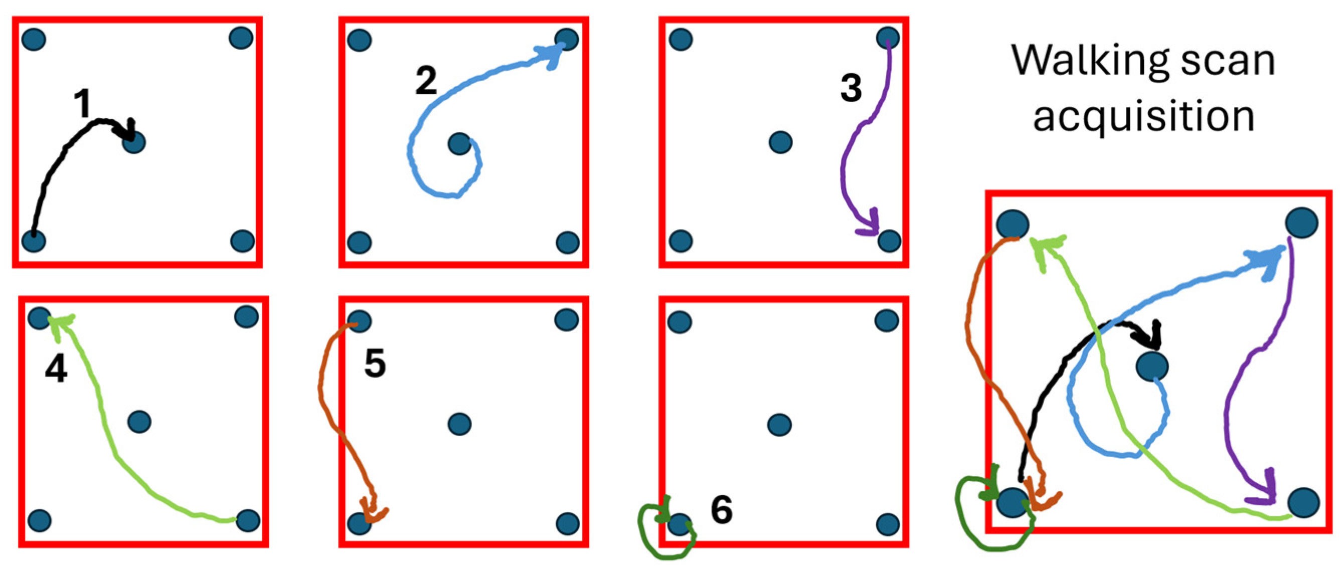
The 3D point cloud data acquisition was carried out on the same day as the traditional field measurements in each marteloscope, under optimal conditions with no wind or wet surfaces. The operator walked over the entire 50 m × 50 m marteloscope plot while holding the scanner and following the path scheme shown in Figure 2. This route was designed to minimize walking effort, considering the 100 m range of the ZEB Horizon RT. The scan acquisitions were carefully planned in advance to ensure full area coverage and maintain consistent orientation. The walking scheme followed a side-to-side, zig-zag trajectory at a slow pace, consisting of six recursive segments. After reaching each vertex, the operator paused for at least 10 s to allow the system to register a control point. Once the entire plot was covered, the walks ended at the same point as the starting point. Here, the scanner was placed in the same position and orientation for approximately 10 s to finalize the scan (Figure 2).

2.3.3. MLS Point Cloud Processing

The data from each scan were processed using Faro Connect 2024 v4.0 software to generate a 3D point cloud (Figure 3, Figure 4 and Figure 5). The “.geoslam” files acquired by GroSLAM ZEB HORIZON RT were processed through a standard workflow with a specific “Forest” environment setting. The software also allowed the 3D point cloud to be georeferenced within a geographic system using the “Adjust to Control” tools, which identify the reference points. The georeferenced point clouds were then exported in “.las” format.
Subsequently, the point clouds underwent further processing using LiDAR360 v 5.0 desktop software [59], which incorporated semi-automatic data extrapolation algorithms, following the methodology outlined in Sofia et al. (2022) [36]. Stand-alone software with a user-friendly interface was chosen to eliminate the need for programming skills (e.g., R or Python), making it more accessible and convenient for forest managers and training activities.
To derive tree- and marteloscope-level data, the point clouds were processed in the LIDAR360 v5.0 software through the following four steps; namely, (i) each point cloud was cropped to the area of the field plots using the referenced points (i.e., 4 corners); (ii) the point cloud was cleaned of outliers using the “remove outliers” function, which was set to remove low- and high-level outliers; particularly, the function allowed setting (a) the Neighbor Points, representing the number of points required in the neighborhood to calculate the average distance of each point (setting value was 10); and (b) the Multiples of standard deviation, as the factor multiplied by the standard deviation to calculate the maximum distance (function setting was 5); (iii) the point cloud was binary classified into ground and non-ground points using the “Filter Ground Points” function using the default settings for the three parameters (a) Grid Size (grid resolution equal to 0.5 m); (b) Ground Thickness (0.3 m, values between the lowest value of the grid and the thickness of 0.3 were classified as ground points.); and (c) Window Size (referring to the size of the neighborhood window; in our case, 3 indicates a window size of 3 × 3 points), and then normalized using the “Normalize by Ground Points” function by subtracting the terrain elevation of the closest ground point to each point [59,60]; (iv) the normalized point cloud was used to segment each tree within the plot and automatically extract tree-level data (i.e., position, DBH, and H). Among the several function settings, in our study, we set (a) From Class allowing the inclusion of all classes in the point cloud segmentation; (b) Cluster Tolerance as 0.2 m, to control the accuracy and efficiency of the process; specifically, increasing the value resulted in higher efficiency but lower accuracy; (c) Minimum Cluster Size equal to 500 referring to the point cloud of individual tree crown; (d) Maximum and (e) Minimum DBH equal to 57 cm and 7 cm, respectively; (f) Height Above Ground set to 0.3 m to include points involved in individual tree segmentation; (g) Minimum Tree Height of 2 m; (h) Trunk Height equal to 1.6 m, which together with the Height Above Ground allows the trunk identification; (i) Optimize color rendering for individual tree segmentation result was selected to avoid the same color for adjacent trees. The LIDAR360 software facilitates tree segmentation through an implemented algorithm that fitted a circle to the tree stem and classified it into three levels: Low, Medium, and High. The segmentation method, proposed by Tao et al. (2015) [61], allowed for the identification of individual trees using a bottom-up approach, which is preferred for high-density LiDAR data, as stems can be easily identified from ground under the canopy. After segmentation of individual trees, the software automatically extracted tree inventory parameters, namely, position, DBH, and height of each tree in the plot, and exports the data to a spreadsheet-based CSV file [59,61]; (v) finally, the tree-level data (DBH, height) were used to estimate stand wood volume (GSV, m3) using the equations of Tabacchi et al. (2011) [58], as for traditional measurements, to ensure data comparability.

2.4. Methodology

To compare traditional and digital marteloscopes, we evaluated the acquisition times of the MLS, personnel cost, and the data generated through automatic processing of point clouds with those obtained from traditional forest marteloscope surveys in three coniferous forests.
Specifically, the comparison focused on two sub-objectives: (i) assessing the time and costs required to establish a marteloscope using traditional versus the MLS methods; and (ii) testing the application of the digital marteloscope (i.e., MLS point clouds) by simulating several silvicultural operations.
The results were then compared with those obtained from the traditional marteloscope approach.

2.4.1. Comparison of Time and Costs Between Traditional and MLS Marteloscope Implementation

To compare the implementation of a traditional marteloscope with the MLS marteloscope, we recorded the time required for both field acquisition and data processing. Specifically, for the traditional marteloscope, we recorded the time required for field acquisition (including geolocation of all trees, DBH, and H measurements) and data processing (downloading the data, geographic transformations, and GSV estimation). For the MLS, we recorded the time required for field scan acquisition (i.e., walking scan acquisition) and point cloud processing (i.e., GEOSLAM processing using Faro Connect, extraction of single tree attributes with LIDAR360, and growing stock estimation).
A detailed comparative analysis in terms of the time and cost was carried out, focusing on (i) field data collection and (ii) data analysis. The cost analysis was carried out by multiplying the work duration by the Italian national price for forestry workers, set at EUR 25 per hour for a junior forester [62]. During the field phases, traditional field measurements required four people, while the MLS needed two persons. For data processing, the work of one person was assumed for both methods. It is important to note that when comparing the costs between traditional and MLS marteloscopes, we did not consider the cost of the equipment, which included the amortization and training to use the MLS. Furthermore, the same computer was used to process both the traditional and MLS data, with the following specifications: AMD Ryzen Thread ripper 2970WX 24-Core Processor running at 3.00 GHz using 64 GB of RAM; NVIDIA Quadro P620 graphic card; Windows 11 operating system.

2.4.2. Simulation Forest Intervention Between Traditional and MLS Marteloscope

The thinning simulations—in both the MLS and traditional marteloscope—were conducted by a forestry technician with extensive experience in sustainable forest management. This technician possessed a deep understanding of ecological processes, legal regulations, and a wealth of practical experience in performing thinning operations. The technician underwent five days of training to work with point clouds and, in both cases, the selection of trees to be cut was based on professional experience rather than following a standard algorithm.
It is also important to note that when the technician performed the thinning simulations in the MLS, he had already visited and measured the traditional marteloscope plots, gaining knowledge of all three marteloscopes. However, the MLS simulation was conducted before the traditional marteloscope thinning. Therefore, any difference in the number of trees cut between the MLS and traditional marteloscope can also be attributed to the different decision-making processes in the two approaches.

2.4.3. Evaluation of Forest Variables Assessment Between Traditional and MLS Marteloscope

The traditional and MLS methods were compared within each marteloscope based on the absolute difference in both the growing stock volume (GSV) and in trees count (N). In addition, the associated error for the two methods was evaluated by root mean square error (RMSE), percentage R M S E % , and bias, as follows:
R M S E = i = 1 n ( X T S X M L S ) 2 n
R M S E % = R M S E X ¯ 100
b i a s = i = 1 n ( X T S X M L S ) n
where n represented the number of trees resulting from the traditional measures (TS), XTS was the value of the i-th tree variable estimated by the traditional method, and XMLS by processing the MLS scans; X was the mean value of the tree variable computed by the traditional approach. In addition, GSV and N were compared for felling, to assess the differences between simulated silvicultural operations using the two (traditional and MLS) approaches.

3. Results

Table 1 showed the time taken to set up a marteloscope using both the traditional and the MLS approaches for the three study areas. The results showed considerable variability in terms of time. Compared to the traditional method, the MLS approach generally offered a time advantage, saving about 40 min for less complex forest (Douglas-fir and Stone pine) and around 3 h for more complex forests (Italian cypress) (Table 1).
When comparing the time and cost of data collection between the two survey methods, MLS data collection resulted in being faster and less expensive (Table 2). Similar findings were obtained for data processing. Regarding costs, MLS data collection differed significantly across forest types and densities. Costs were generally higher for Italian cypress stand, while the costs for Douglas-fir and Stone pine were comparable. In terms of cost saving, the MLS resulted in savings of EUR 104.2 and EUR 80.0 for Douglas-fir and Stone pine, respectively. In the Italian cypress forest, the savings were higher, reaching EUR 328.3 (Table 2).
Differences in the number of detected trees (N) and growing stock volume (GSV) were reported in Table 3. For N, no significant differences were observed between the two methods in Douglas-fir and Stone pine (p-value of 0.54). However, significant differences were found for the Italian cypress stand, where more trees were detected by the MLS than by the traditional survey (p-value of 0.03*). Similarly, the Italian cypress GSV value estimated by the MLS was significantly higher than in the traditional survey. In the other two forest types (Douglas-fir and Stone pine), the GSV differences were below 28 m3. In both cases, the MLS underestimated the stand volume compared to the traditional approach.
As shown in Table 4, errors associated with the GSV estimates (RMSE and RMSE%) were similar between the two methods, with no significant differences (p-value of 0.53).
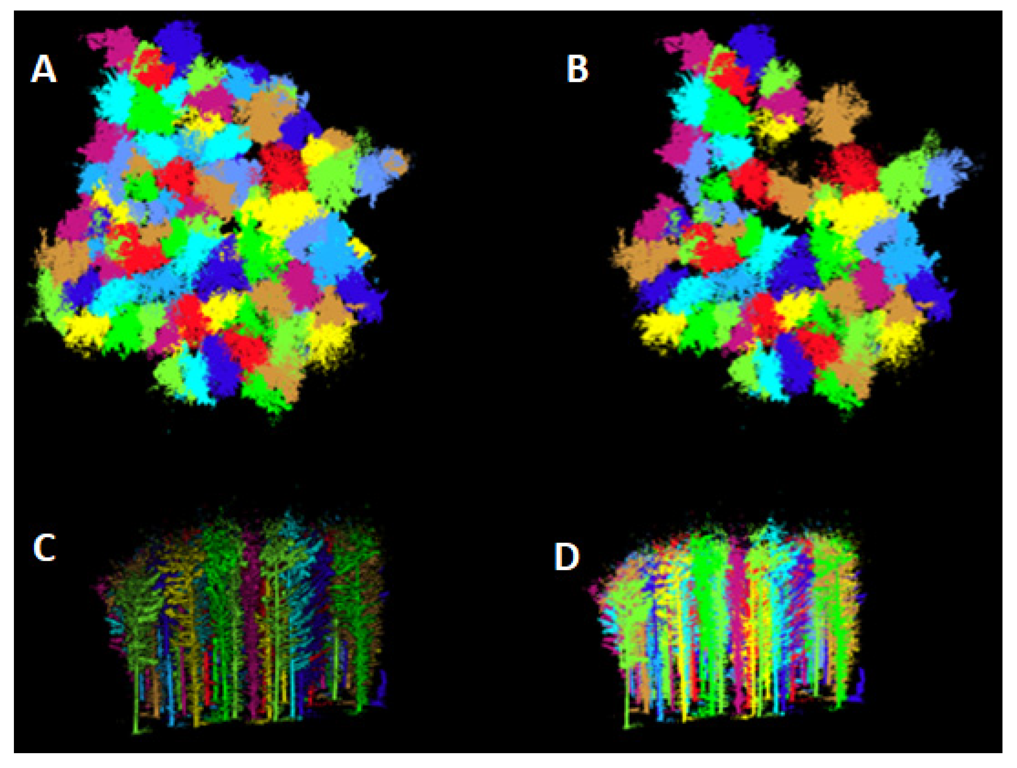
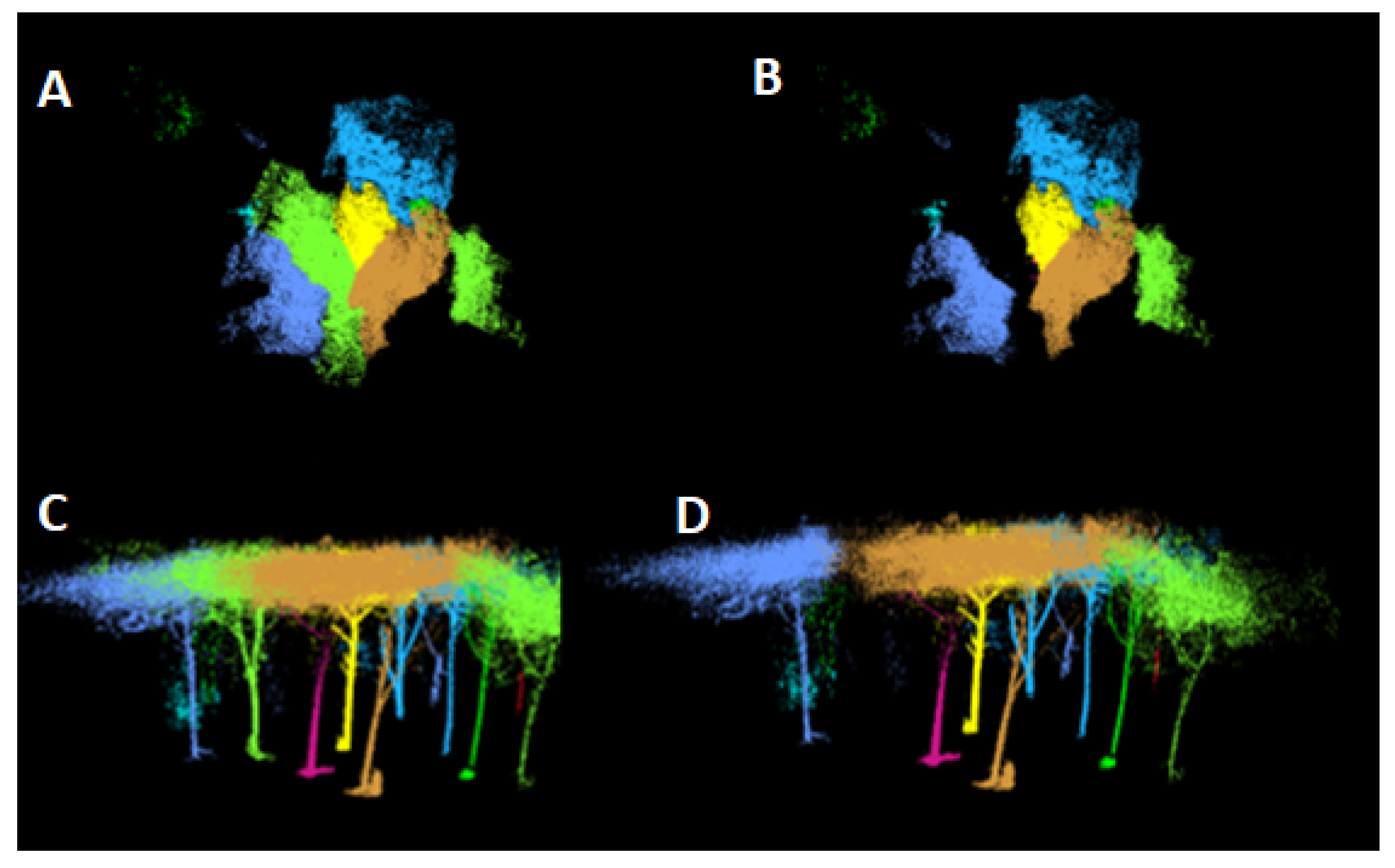
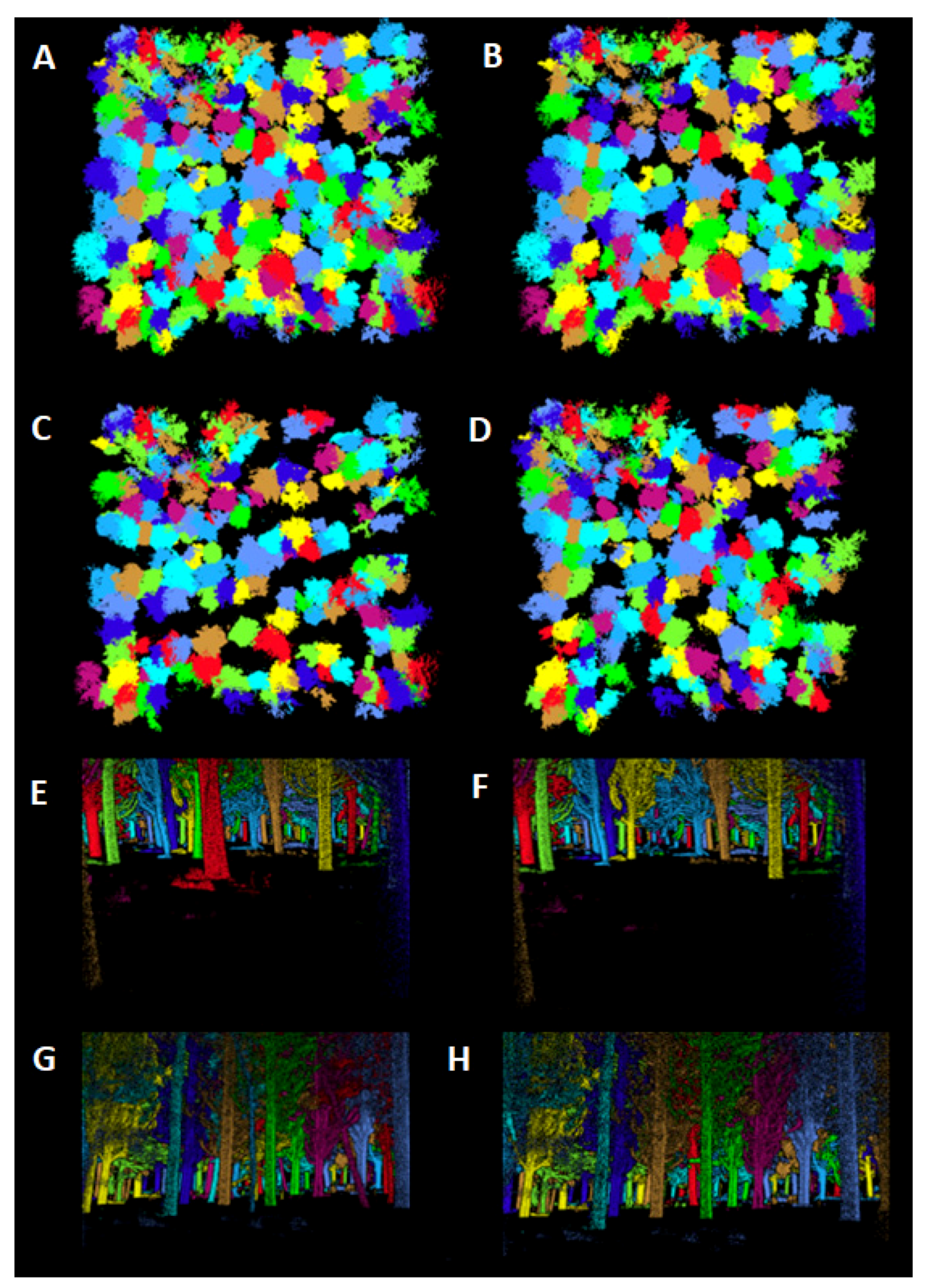
Figure 3, Figure 4 and Figure 5 give an overview of the marteloscopes and the cuttings made in the MLS marteloscopes. Simulated silvicultural operations for the MLS were carried out using scanned trees that matched those measured in the field. The results for N and GSV are reported in Table 5. No significant difference was observed between the two methods in the number of trees felled. However, for selective thinning in the Italian cypress forest, a great difference in the GSV was noted, though no significant difference in the tree number (N) was found (Table 5). A great difference in the number of trees cut between the traditional and MLS marteloscope was observed for geometric thinning in the Italian cypress forest, with more (+8) trees removed in the MLS.
Simulated and in-the-field measurements were consistent in terms of the GSV and N for from-below thinning for Douglas-fir and gap cutting for the regeneration of Stone pine forests (Table 5).

4. Discussion

The application of ZEB HORIZON RT laser scanner technology in this study demonstrated that MLS marteloscopes could be established more efficiently and cost-effectively than traditional methods. Across the three forests, the average time saving was 1 h and 29 min per marteloscope, translating to an average economic saving of EUR 170, based on the typical Italian forester income. It is important to note that the estimated costs were calculated based on average Italian wage rates and may vary significantly in regions where labor costs are higher.
When comparing the two methods for establishing a marteloscope, it was found that in more complex forest structures—such as the Italian cypress stand, which was characterized by higher tree density and steeper slopes—the MLS acquisition time resulted in a time saving of 3 h. This translated into an economic saving ten times greater than the traditional method (Table 1). Conversely, the Stone pine marteloscope—with its simpler structure characterized by lower tree density and flat terrain—showed smaller differences in both time and cost. However, our study demonstrated a greater time saving compared to Tupinambá-Simões et al.’s (2023) marteloscope [18], which evaluated a mixed forest in Spain using the MLS ZEB-Horizon.
The variation in time required to establish traditional marteloscopes across different forest stands was largely due to differences in forest complexity. In the more structurally complex Italian cypress marteloscope, the total station used to georeference the position of trees had to be repositioned nine times to ensure visibility of all trees. In contrast, in the Douglas-fir and Stone pine stands, it was only moved once. Furthermore, the number of trees requiring caliper measurements (i.e., tree density) significantly impacted the time needed for data acquisition. No time difference was observed for the MLS approach, where the acquisition times were more consistent across all forest stands, regardless of forest complexity, density, or slope (Table 2). This consistency likely results from the standardized protocol for the walking path used across all marteloscopes. However, it was important to note that other studies had shown that the accuracy of MLS point clouds could depend on the length of the walking path. Specifically, longer walking paths required more time for acquisition but improved the accuracy of segmentation and the extraction of individual tree parameters, by increasing the point cloud density [57,63]. In our study, we did not investigate this effect, as we used only a single walking path. In contrast, the stand density had a greater impact on the measurements and establishment of traditional marteloscopes, as direct measurement with manual basic tools such as calipers, vertex, and topographic devices was labor-intensive and time-consuming [22,64].
These findings suggested that the MLS had a great potential to overcome the challenge of a traditional field survey [22]. However, our results for the Italian cypress marteloscope showed inconsistent outcomes in terms of detected trees, with the MLS counting a significantly higher (+145%) number of trees compared to the traditional marteloscope. This higher detection rate was aligned with Kükenbrink et al. (2022) [43], who reported a +26% increase in single tree detections using the MLS ZEB REVO in a complex Swiss mixed temperate forest, although it was lower compared to our study. In our case, the errors can be attributed to two main factors. Firstly, the presence of standing dead trees in the marteloscope, which were not measured in the traditional survey. Distinguishing between standing dead and live trees was a challenging task for the MLS. However, recent studies using artificial intelligence networks have shown that LiDAR data were able to accurately classify dead and live trees [65,66]. Secondly, some errors might have arisen from the omission of some trees during the traditional field survey. In complex and high-density forest stands, the likelihood of overlooking individual trees increased due to the challenges in accurately identifying and measuring all specimens within the plot. Nevertheless, for the other two types of marteloscopes, the results were comparable to traditional surveying in terms of the density (N) for both the Douglas-fir forest and the Stone pine forest (Table 2), showing an even better accuracy when compared to the results of recent studies, such as the one conducted in Swiss mixed temperate forests using ZEB REVO [43] and in Spanish mixed forests using the ZEB Horizon [18].
The GSV, limited to the matched trees, appeared to be underestimated by the MLS with respect to the traditional survey in all three marteloscopes, although the same equations were used (Table 2). This was likely due to differences in height estimation between the two survey approaches. In fact, in the traditional marteloscope, height was either measured directly or estimated from the local hypsometric curve, whereas in the MLS survey, tree height was derived from the point cloud of each segmented tree. Previous studies reported that height estimates from TLS/MLS and traditional instruments were not without error, as occlusions could occur when scanning the top of the tree from the ground or when attempting to measure the tree top with a hypsometer [67,68]. This challenge was even greater in vertically complex forests with dense canopies [67,69]. Accurate estimation of the tree height from the ground using traditional hypsometers was generally associated with technical experience [64]. However, it is important to note in our study that the conifer tree tops selected for the hypsometric curve were all well visible, even at a wide distance, so the error in vertex measurements should be minimal. However, we estimated most of the tree heights using the hypsometric curve, and so errors could be greater. As shown in a recent study by Wang et al. [70], field measurements of height were more sensitive to stand complexity and tend to overestimate tree height for tall trees with codominant crowns, as was the case for most trees in our three even-aged marteloscopes. Wang et al. [70] also highlighted that reliable tree height estimates from TLS could be expected for trees ranging from 15 to 20 m in height, depending on the complexity of the forest. In fact, for TLS measurements, the complexity of the forest structure could hinder the quality of the 3D reconstruction [16,70]. To reduce the errors, some studies showed that the accuracy of tree height could be improved by merging ground-based point clouds from TLS/MLS with airborne or UAV-based point clouds [68,70,71,72,73]. However, a visual analysis of the point cloud of each segmented tree in our three marteloscopes did not reveal any shortcomings in the MLS tree top detection. This could be attributed to the fact that, compared to other types of TLS devices, the ZEB HORIZON RT used in this study has a wider operational range, reaching up to 100 m, in contrast to the less than 35 m of previous models in the ZEB series, such as ZEB1 [16,74] or ZEB REVO [67]. So, errors in tree height and consequently in volume estimation were mainly due to errors in the traditional field measures. Moreover, in our data acquisition, meteorological conditions were optimal, with no wind or wet surfaces, providing the ideal environment for data collection. As highlighted in previous studies, scanning operations are highly sensitive to weather, and unfavorable conditions can delay the process or significantly alter trees’ characteristics, especially linked with the canopy and in the identification of the tree top [75]. For example, wet conditions such as mist, fog, or rain not only affect the transmission of laser pulses but also alter the scattering properties of both tree canopies and the ground [76]. Scanning had to be resumed only after leaves had dried and conditions beneath the canopy had cleared [76]. Similarly, windy conditions were suboptimal, as even slight tree movements caused by light breezes could lead to ghosting effects in the point cloud [76]. Seidel et al. (2012) recommended limiting scans to periods when wind speeds were below 5 m/s to ensure data quality [77].
The use of stand-alone LiDAR 360 software proved to be reliable and fast for segmenting individual trees [33,36], especially when compared to developing segmentation codes in R or Python programming languages [16,33]. This software, with its simple graphical interface, was easy to use even for inexperienced operators. However, in more complex structures, such as the Italian cypress forest, additional checks were needed after segmentation, as in some cases it mistakenly segmented trees with very large diameters that were not actually present in the stand and had to be manually removed. In contrast, the dense understory and ground dead wood (i.e., large branches on the ground) in the Stone pine forest required more precise settings to accurately identify individual trees. From an operational standpoint, a longer survey time with more complex walking paths [57,63] might have been useful for generating a denser point cloud, which could have simplified the segmentation process and improved the detection of individual trees.
Thinning simulations using MLS point clouds and traditional marteloscopes were similar in both Douglas-fir and Stone pine stands, as no significant differences were found in terms of the number of trees removed or the growing stock volume (GSV). This similarity was mainly due to the consistency between the two surveys, as previously described. Additionally, no differences were observed in the tree selection between the traditional and MLS marteloscopes when compared with the choices made by the forest technician. However, for the simulated silvicultural treatments in the Italian cypress forest of the Monte Morello area, selective thinning showed a significant difference in the GSV between the traditional and MLS methods. These discrepancies could be attributed to the different subjective selection of trees, which differed between the traditional and MLS marteloscopes. In both geometric and from-below thinning in Italian cypress marteloscopes, differences in GSV estimation between the two methods were minimal, as only small variations were observed. Notably, although the forest technician chose to remove more trees during the geometric thinning with the MLS compared to the traditional marteloscopes (Table 5), this did not result in differences in GSV estimation between the two approaches, as the variations remained relatively minor. For selective thinning, it was important to note that MLS analysis offered the additional advantage of analyzing each individual tree separately. The extraction process provided a 360° view of each tree, allowing for a detailed examination of the tree, including knots, structural defects, and trunk eccentricities. This approach enabled objective, potentially repeatable analysis for each tree, offering a more robust approach that is difficult to achieve with traditional field methods. While traditional marteloscopes relied on foresters marking trees based on numerical data to verify that the planned harvest volume was met, using tools like Smartelo [38], MLS data significantly reduce subjectivity in the decision-making process. This shift allowed for more data-driven decisions, moving away from operator-based, subjective criteria and towards an objective, quantitative approach [38].
Our results highlighted how the use of the MLS led to the establishment of new marteloscopes at a lower cost across different forest structures and types. This was essential for the training operators in tree selection, or for applying various silvicultural techniques, emphasizing the importance of these demonstration areas [38,39,44]. The results of this study, consistent with those of Tupinambá-Simões et al. (2023) [18,19], showed that digital marteloscopes were not only useful for training people in forestry, but also to demonstrate how effective and efficient MLS technology could be in forestry.
This work represents one of the first examples of implementing digital marteloscopes using MLS. An advantage of this technology lay in the possibility of updating marteloscope data through successive scans carried out over time. As previously highlighted, marteloscopes played an important role in understanding the dynamics and effects of silvicultural treatments [40,41]. Comparing digital twins led to more precise quantification of these dynamics, including tree growth in terms of the DBH and height, as well as changes in canopy traits. Multiple TLS scans repeated over time effectively monitored forest dynamics [78].
However, the relatively high cost of purchasing the equipment (approximately EUR 57,000 for the ZEB HORIZON RT) remained a significant drawback. Fortunately, other manufacturers began offering similar instruments at a more affordable price. Moreover, technological advances and the growing use of this technology in important industrial sectors, such as the automotive industry, likely contributed to further reducing the equipment costs, making it more accessible to a wider audience [22].

5. Conclusions

This work highlighted how the MLS represented an efficient tool for surveying forests and marteloscope creation in a cost-effective way. The use of the MLS enabled the digital reconstruction of forest stand structure and the extraction of forest variables, such as the DBH and H, at a significant cost reduction compared to traditional survey techniques.
Despite some discrepancies in tree detection in more complex stands, the MLS approach proved to be reliable and showed comparable or better accuracy than traditional methods in most forest types.
This study represented an important first step in demonstrating that MLS technology could truly support forestry technicians involved in silviculture and sustainable forest management. Thanks to the cost reduction associated with this technology, it would be possible to implement more marteloscopes, thereby expanding monitoring and teaching areas. These new marteloscopes could integrate traditional teachings with those on the use of MLS technology, offering unique opportunities for professional development. In fact, after just 5 days of training, the forest technicians involved in this study were able to independently work on tree selection, demonstrating the effectiveness of the training and the speed with which skills could be acquired in using innovative tools. Moreover, the use of the MLS also allowed analyzing point clouds for an immediate assessment of the effects of proposed silvicultural operations on the stand. This provided the operator with a real-time view of the intensity of the proposed silvicultural treatment. However, further comparisons involving several different operators in the use of point clouds were needed to understand any difficulties and critical issues in the use of this technology.
It would be useful to extend the study to other areas characterized by different forest types, including broadleaf forests, to fully understand its potential. Additionally, in this study, we have not considered metrics related to the canopy, such as canopy cover or crown volume, which are important for simulating regeneration cuttings or for applying close-to-nature silvicultural techniques, such as in continuous-cover forestry or in conversion from even to irregular/uneven-aged forests or from single- to multiple-story stands. The implementation of these metrics can allow canopy cover estimate and gaps distribution after forest operations, and thus the calculation of radiation (and other ecophysiological parameters) at ground level, where regeneration could take place.

Author Contributions

Conceptualization: F.G. and Y.G.; data acquisition: G.A., L.P., C.B., S.A., G.D., D.T., Y.G., E.V. and P.R.; data curation: G.D. and G.A.; formal Analysis: G.D., G.A. and F.G.; methodology: F.G. and G.D.; supervision: F.G., G.D. and Y.G.; visualization: G.D., G.A. and F.G.; writing—original draft: F.G., L.P., S.R., G.D. and C.B.; writing—review and editing: B.M., A.M., E.V., A.B.-O., G.C., D.T. and P.R.; funding acquisition and resources: F.G., G.C., D.T., Y.G. and S.R. All authors have read and agreed to the published version of the manuscript.

Funding

The work was carried out in the framework of (i) the Horizon Europe project “SMURF—Sustainable Management models and valUe chains foR small Forests—Grant Agreement n. 101135516”; (ii) the project funded under the National Recovery and Resilience Plan (NRRP), Mission 4 Component 2 Investment 1.4—Call for tender No. 3138 of 16 December 2021, rectified by Decree n.3175 of 18 December 2021 of Italian Ministry of University and Research funded by the European Union—NextGenerationEU under award Number: Project code CN_00000033, Concession Decree No. 1034 of 17 June 2022 adopted by the Italian Ministry of University and Research, CUP B83C22002930006, Project title “National Biodiversity Future Centre—NBFC”; (iii) the project founded under the Misura 16.2 del Programma di sviluppo rurale 2014–2020 della Regione Toscana per l’impiego delle risorse del Fondo europeo agricolo per lo sviluppo rurale (Psr Feasr 2014–2020) “Progetto Do.Na.To.—Douglasiete Naturali Toscane”; (iv) The LIFE PROGRAMME OF EUROPEAN UNION, grant number LIFE18ENV/IT/000124 LIFE SySTEMiC; (v) the Horizon Europe “OptFor-EU OPTimising FORest management decisions for a low-carbon, climate resilient future in Europe Grant agreement n°101060554.

Data Availability Statement

The scans and data will be made available upon request to the corresponding author.

Conflicts of Interest

Authors Francesca Giannetti, Gianfrancesco Aleandri and Yamuna Giambastiani were founder members or employed by the company Bluebiloba Startup Innovativa s.r.l. The remaining authors declare that the research was conducted in the absence of any commercial or financial relationships that could be construed as a potential conflict of interest.

References

  1. European Commission. New EU Forest Strategy for 2030; 2021; pp. 5–24. Available online: https://efi.int/news/new-eu-forest-strategy-2030-new-understanding-sustainable-forest-management-2022-02-22 (accessed on 22 September 2024).
  2. Winkel, G.; Lovrić, M.; Muys, B.; Katila, P.; Lundhede, T.; Pecurul, M.; Pettenella, D.; Pipart, N.; Plieninger, T.; Prokofieva, I.; et al. Governing Europe’s Forests for Multiple Ecosystem Services: Opportunities, Challenges, and Policy Options. For. Policy Econ. 2022, 145, 102849. [Google Scholar] [CrossRef]
  3. Lier, M.; Köhl, M.; Korhonen, K.T.; Linser, S.; Prins, K.; Talarczyk, A. The New EU Forest Strategy for 2030: A New Understanding of Sustainable Forest Management? Forests 2022, 13, 245. [Google Scholar] [CrossRef]
  4. European Commission. Communication from the Commission to the European Parliament, the Council, the European Economic and Social Committee and the Committee of the Regions; European Commission: Brussels, Belgium, 2012. [Google Scholar]
  5. European Commission. EU Soil Strategy for 2030 Reaping the Benefits of Healthy Soils for People, Food, Nature and Climate; European Commission: Brussels, Belgium, 2021. [Google Scholar]
  6. Ramiro Troitiño, D. The European Commission, the Council, and the European Parliament: Differentiated Theoretical Frame for the Digital Revolution. In Digital Development of the European Union: An Interdisciplinary Perspective; Springer: Berlin/Heidelberg, Germany, 2023; pp. 349–361. [Google Scholar]
  7. European Commission. Guidelines on Closer-to-Nature Forest Management; European Commission: Brussels, Belgium, 2023; ISBN 9789268002070. [Google Scholar]
  8. Singh, R.; Gehlot, A.; Vaseem Akram, S.; Kumar Thakur, A.; Buddhi, D.; Kumar Das, P. Forest 4.0: Digitalization of Forest Using the Internet of Things (IoT). J. King Saud Univ. Comput. Inf. Sci. 2022, 34, 5587–5601. [Google Scholar] [CrossRef]
  9. Prins, K.; Köhl, M.; Linser, S. Is the Concept of Sustainable Forest Management Still Fit for Purpose? For. Policy Econ. 2023, 157, 103072. [Google Scholar] [CrossRef]
  10. Nitoslawski, S.A.; Wong-Stevens, K.; Steenberg, J.W.N.; Witherspoon, K.; Nesbitt, L.; Konijnendijk van den Bosch, C.C. The Digital Forest: Mapping a Decade of Knowledge on Technological Applications for Forest Ecosystems. Earth’s Future 2021, 9, 1–28. [Google Scholar] [CrossRef]
  11. Urzedo, D.; Westerlaken, M.; Gabrys, J. Digitalizing Forest Landscape Restoration: A Social and Political Analysis of Emerging Technological Practices. Environ. Politics 2023, 32, 485–510. [Google Scholar] [CrossRef] [PubMed]
  12. Cadez, L.; Giannetti, F.; de Luca, A.; Tomao, A.; Chirici, G.; Alberti, G. A WebGIS Tool to Support Forest Management at Regional and Local Scale. IForest 2023, 16, 361–367. [Google Scholar] [CrossRef]
  13. Corona, P.; Marchi, E.; Chirici, G. Prospettive e Potenzialità della Digitalizzazione del Settore Forestale in Italia Linee Guida; Rete Rura-le Nazionale 2014–2020; Consiglio per la Ricerca in Agricoltura e l’Analisi Dell’Economia Agraria: Rome, Italy, 2022; ISBN 9788833852157. [Google Scholar]
  14. Chianucci, F.; Puletti, N.; Grotti, M.; Ferrara, C.; Giorcelli, A.; Coaloa, D.; Tattoni, C. Nondestructive Tree Stem and Crown Volume Allometry in Hybrid Poplar Plantations Derived from Terrestrial Laser Scanning. For. Sci. 2020, 66, 737–746. [Google Scholar] [CrossRef]
  15. D’Amico, G.; Vangi, E.; Francini, S.; Giannetti, F.; Nicolaci, A.; Travaglini, D.; Massai, L.; Giambastiani, Y.; Terranova, C.; Chirici, G. Are We Ready for a Web-Based National Forest Information System? State of the Art of for-Est Maps and Airborne Laser Scanning Data Availability in Italy. IForest 2021, 14, 144–154. [Google Scholar] [CrossRef]
  16. Giannetti, F.; Puletti, N.; Quatrini, V.; Travaglini, D.; Bottalico, F.; Corona, P.; Chirici, G. Integrating Terrestrial and Airborne Laser Scanning for the Assessment of Single Tree Attributes in Mediterranean Forest Stands. Eur. J. Remote Sens. 2018, 51, 795–807. [Google Scholar] [CrossRef]
  17. Venanzi, R.; Latterini, F.; Civitarese, V.; Picchio, R. Recent Applications of Smart Technologies for Monitoring the Sustainability of Forest Operations. Forests 2023, 14, 1503. [Google Scholar] [CrossRef]
  18. Tupinambá-Simões, F.; Pascual, A.; Guerra-Hernández, J.; Ordóñez, C.; de Conto, T.; Bravo, F. Assessing the Performance of a Handheld Laser Scanning System for Individual Tree Mapping—A Mixed Forests Showcase in Spain. Remote Sens. 2023, 15, 1169. [Google Scholar] [CrossRef]
  19. Waeber, P.O.; Melnykovych, M.; Riegel, E.; Chongong, L.V.; Lloren, R.; Raher, J.; Reibert, T.; Zaheen, M.; Soshenskyi, O.; Garcia, C.A. Fostering Innovation, Transition, and the Reconstruction of Forestry: Critical Thinking and Transdisciplinarity in Forest Education with Strategy Games. Forests 2023, 14, 1646. [Google Scholar] [CrossRef]
  20. MIPAF. Strategia Forestale Nazionale; MIPAF: Rome, Italy, 2021; ISBN 9788898850341. [Google Scholar]
  21. Chapin, F.S.; Carpenter, S.R.; Kofinas, G.P.; Folke, C.; Abel, N.; Clark, W.C.; Olsson, P.; Smith, D.M.S.; Walker, B.; Young, O.R.; et al. Ecosystem Stewardship: Sustainability Strategies for a Rapidly Changing Planet. Trends Ecol. Evol. 2010, 25, 241–249. [Google Scholar] [CrossRef] [PubMed]
  22. Liang, X.; Kukko, A.; Balenović, I.; Saarinen, N.; Junttila, S.; Kankare, V.; Holopainen, M.; Mokroš, M.; Surový, P.; Kaartinen, H.; et al. Close-Range Remote Sensing of Forests: The State of the Art, Challenges, and Opportunities for Systems and Data Acquisitions. IEEE Geosci. Remote Sens. Mag. 2022, 10, 32–71. [Google Scholar] [CrossRef]
  23. Murtiyoso, A.; Holm, S.; Riihimäki, H.; Krucher, A.; Griess, H.; Griess, V.C.; Schweier, J. Virtual Forests: A Review on Emerging Questions in the Use and Application of 3D Data in Forestry. Int. J. For. Eng. 2024, 35, 34–47. [Google Scholar] [CrossRef]
  24. Magnuson, R.; Erfanifard, Y.; Kulicki, M.; Gasica, T.A.; Tangwa, E.; Mielcarek, M.; Stereńczak, K. Mobile Devices in Forest Mensuration: A Review of Technologies and Methods in Single Tree Measurements. Remote Sens. 2024, 16, 3570. [Google Scholar] [CrossRef]
  25. Miller, J.; Morgenroth, J.; Gomez, C. 3D Modelling of Individual Trees Using a Handheld Camera: Accuracy of Height, Diameter and Volume Estimates. Urban For. Urban Green. 2015, 14, 932–940. [Google Scholar] [CrossRef]
  26. Puletti, N.; Grotti, M.; Ferrara, C.; Chianucci, F. Influence of Voxel Size and Point Cloud Density on Crown Cover Estimation in Poplar Plantations Using Terrestrial Laser Scanning. Ann. Silvic. Res. 2021, 46, 148–154. [Google Scholar] [CrossRef]
  27. Kankare, V.; Holopainen, M.; Vastaranta, M.; Puttonen, E.; Yu, X.; Hyyppä, J.; Vaaja, M.; Hyyppä, H.; Alho, P. Individual Tree Biomass Estimation Using Terrestrial Laser Scanning. ISPRS J. Photogramm. Remote Sens. 2013, 75, 64–75. [Google Scholar] [CrossRef]
  28. Ryding, J.; Williams, E.; Smith, M.J.; Eichhorn, M.P. Assessing Handheld Mobile Laser Scanners for Forest Surveys. Remote Sens. 2015, 7, 1095–1111. [Google Scholar] [CrossRef]
  29. Bauwens, S.; Bartholomeus, H.; Calders, K.; Lejeune, P. Forest Inventory with Terrestrial LiDAR: A Comparison of Static and Hand-Held Mobile Laser Scanning. Forests 2016, 7, 127. [Google Scholar] [CrossRef]
  30. Niță, M.D. Testing Forestry Digital Twinning Workflow Based on Mobile Lidar Scanner and Ai Platform. Forests 2021, 12, 1576. [Google Scholar] [CrossRef]
  31. Madrigal, G.; Sixto, H.; Oliveira, N.; Calama, R. Terrestrial Laser Scanning for Non-Destructive Estimation of Aboveground Biomass in Short-Rotation Poplar Coppices. Remote Sens. 2023, 15, 1942. [Google Scholar] [CrossRef]
  32. Calders, K.; Adams, J.; Armston, J.; Bartholomeus, H.; Bauwens, S.; Bentley, L.P.; Chave, J.; Danson, F.M.; Demol, M.; Disney, M.; et al. Terrestrial Laser Scanning in Forest Ecology: Expanding the Horizon. Remote Sens. Environ. 2020, 251, 112102. [Google Scholar] [CrossRef]
  33. Murtiyoso, A.; Cabo, C.; Singh, A.; Obaya, D.P.; Cherlet, W.; Stoddart, J.; Fol, C.R.; Beloiu Schwenke, M.; Rehush, N.; Stereńczak, K.; et al. A Review of Software Solutions to Process Ground-Based Point Clouds in Forest Applications. Curr. For. Rep. 2024, 10, 401–419. [Google Scholar] [CrossRef]
  34. Neudam, L.C.; Fuchs, J.M.; Mjema, E.; Johannmeier, A.; Ammer, C.; Annighöfer, P.; Paul, C.; Seidel, D. Simulation of Silvicultural Treatments Based on Real 3D Forest Data from Mobile Laser Scanning Point Clouds. Trees For. People 2023, 11, 100372. [Google Scholar] [CrossRef]
  35. Díaz-Varela, R.A.; González-Ferreiro, E. 3D Point Clouds in Forest Remote Sensing. Remote Sens. 2021, 13, 2999. [Google Scholar] [CrossRef]
  36. Sofia, S.; Maetzke, F.G.; Crescimanno, M.; Coticchio, A.; La Mela Veca, D.S.; Galati, A. The Efficiency of LiDAR HMLS Scanning in Monitoring Forest Structure Parameters: Implications for Sustainable Forest Management. EuroMed J. Bus. 2022, 17, 350–373. [Google Scholar] [CrossRef]
  37. Faitli, T.; Hyyppä, E.; Hyyti, H.; Hakala, T.; Kaartinen, H.; Kukko, A.; Muhojoki, J.; Hyyppä, J. Integration of a Mobile Laser Scanning System with a Forest Harvester for Accurate Localization and Tree Stem Measurements. Remote Sens. 2024, 16, 3292. [Google Scholar] [CrossRef]
  38. Bravo-Oviedo, A.; Marchi, M.; Travaglini, D.; Pelleri, F.; Manetti, M.C.; Corona, P.; Cruz, F.; Bravo, F.; Nocentini, S. Adoption of New Silvicultural Methods in Mediterranean Forests: The Influence of Educational Background and Sociodemographic Factors on Marker Decisions. Ann. For. Sci. 2020, 77, 48. [Google Scholar] [CrossRef]
  39. Kruse, L.; Erefur, C.; Westin, J.; Ersson, B.T.; Pommerening, A. Towards a Benchmark of National Training Requirements for Continuous Cover Forestry (CCF) in Sweden. Trees For. People 2023, 12, 100391. [Google Scholar] [CrossRef]
  40. John, M.; Wirth, K.; Kaufmann, A.; Ertelt, H.; Frei, T. Forest Deliberations: Marteloscopes as Sites of Encounter between Climate Activists and Forest Managers. For. Policy Econ. 2024, 169, 103356. [Google Scholar] [CrossRef]
  41. O’Brien, L.; Derks, J.; Schuck, A. The Use of Marteloscopes in Science: A Review of Past Research and Suggestions for Further Application; 2022; pp. 1–26. Available online: http://iplus.efi.int/uploads/The_use_of_marteloscopes_in_science_FINAL_24_10.pdf (accessed on 24 September 2024).
  42. Maistrelli, F. I “Martelloscopi” in Alto Adige: 10 Anni D’ Esperienza Pratica Ed Evoluzione Futura. In Proceedings of the 2nd International Congress of Silviculture, Florence, Italy, 26–29 November 2014; pp. 859–863. [Google Scholar]
  43. Kükenbrink, D.; Marty, M.; Bösch, R.; Ginzler, C. Benchmarking Laser Scanning and Terrestrial Photogrammetry to Extract Forest Inventory Parameters in a Complex Temperate Forest. Int. J. Appl. Earth Obs. Geoinf. 2022, 113, 102999. [Google Scholar] [CrossRef]
  44. Kadavý, J.; Kneiflová, J.; Kneifl, M.; Uherková, B. Using Marteloscope in Selection Forestry—Study Case from “Pokojná Hora” (Czech Republic). J. For. Sci. 2024, 70, 447–457. [Google Scholar] [CrossRef]
  45. Santopuoli, G.; Di Cristofaro, M.; Kraus, D.; Schuck, A.; Lasserre, B.; Marchetti, M. Biodiversity Conservation and Wood Production in a Natura 2000 Mediterranean Forest. A Trade-off Evaluation Focused on the Occurrence of Microhabitats. IForest 2019, 12, 76–84. [Google Scholar] [CrossRef]
  46. European Forest Institute. Integrate + Marteloscopes. 2015. Available online: http://www.integrateplus.org/uploads/Files/publications%20updated/20170113_Marteloscope_Methodology_Final.pdf (accessed on 24 September 2024).
  47. Vandendaele, B.; Martin-Ducup, O.; Fournier, R.A.; Pelletier, G.; Lejeune, P. Mobile Laser Scanning for Estimating Tree Structural Attributes in a Temperate Hardwood Forest. Remote Sens. 2022, 14, 4522. [Google Scholar] [CrossRef]
  48. Garbelotto, M.; Gonthier, P. Biology, Epidemiology, and Control of Heterobasidion Species Worldwide. Annu. Rev. Phytopathol. 2013, 51, 39–59. [Google Scholar] [CrossRef]
  49. Capretti, P. Dalle Abetine Di Vallombrosa Nuovi Spunti per La Ricerca in Patologia Forestale. L’Italia For. Mont. 2005, 60, 217–220. [Google Scholar]
  50. Piussi, P.; Alberti, G. Selvicoltura Generale. Boschi, Società e Tecniche Colturali; Compagnia delle Foreste: Arezzo, Italy, 2015; ISBN 9788898850112. [Google Scholar]
  51. Gei, F.; Fastelli, D.; Maetzke, F.G.; Gestri, G.; Peruzzi, L. Calvana e Monte Morello. Due Rilievi a Confronto. Geografia, Geologia, Climatologia, Rimboschimenti, Vegetazione e Flora Vascolare; Tipografia Linari: Florence, Italy, 2016; ISBN 9788887553222. [Google Scholar]
  52. Paletto, A.; De Meo, I.; Cantiani, P.; Guerrini, S.; Lagomarsino, A. Social Perception of Forest Management: The Case of the Peri-Urban Forest of Monte Morello (Florence, Italy). For. Riv. Selvic. Ecol. For. 2018, 15, 29–39. [Google Scholar] [CrossRef]
  53. De Frutos, S.; Bravo-Fernández, J.A.; Roig-Gómez, S.; Del Río, M.; Ruiz-Peinado, R. Natural Regeneration and Species Diversification after Seed-Tree Method Cutting in a Maritime Pine Reforestation. IForest 2022, 15, 500–508. [Google Scholar] [CrossRef]
  54. Chudy, R.; Cubbage, F.; Siry, J.; Chudy, J. The Profitability of Artificial and Natural Regeneration: A Forest Investment Comparison of Poland and the U.S. South. J. For. Bus. Res. 2023, 1, 1–20. [Google Scholar] [CrossRef]
  55. Bianchi, L.; Giovannini, G.; Paci, M. La Selvicoltura Delle Pinete Della Toscana. (Pine Forestry in Tuscany); Agenzia Regionale per lo Sviluppo e l’Innovazione nel settore Agricolo-forestale, Press Service, Sesto Fiorentino (FI): Florence, Italy, 2005; ISBN 88-8295-064-6. [Google Scholar]
  56. Bernetti, G. Botanica e Selvicoltura—26 Il Taglio A Buche Nella Rinaturalizzazione Delle Pinete D’impianto. L’Italia For. Mont. 2003, 58, 143–145. [Google Scholar]
  57. Chirici, G.; Giannetti, F.; D’Amico, G.; Vangi, E.; Francini, S.; Borghi, C.; Corona, P.; Travaglini, D. Robotics in Forest Inventories: SPOT’s First Steps. Forests 2023, 14, 2170. [Google Scholar] [CrossRef]
  58. Tabacchi, G.; Di Cosmo, L.; Gasparini, P.; Morelli, S. Stima del Volume e Della Fitomassa Delle Principali Specie Forestali Italiane; Equazioni di previsione, tavole del volume e tavole della fitomassa arborea epigea; Consiglio per la Ricerca e la sperimentazione in Agricoltura, Unità di Ricerca per il Monitoraggio e la Pianificazione Forestale: Trento, Italy, 2011; ISBN 9788897081111. [Google Scholar]
  59. Green Valley International LiDAR360 V5.0 User Guide Imprint and Version. 2021. Available online: https://greenvalleyintl.com/static/upload/file/20210817/1629190611196646.pdf (accessed on 24 September 2024).
  60. Shang, C.; Treitz, P.; Caspersen, J.; Jones, T. Estimation of Forest Structural and Compositional Variables Using ALS Data and Multi-Seasonal Satellite Imagery. Int. J. Appl. Earth Obs. Geoinf. 2019, 78, 360–371. [Google Scholar] [CrossRef]
  61. Tao, S.; Wu, F.; Guo, Q.; Wang, Y.; Li, W.; Xue, B.; Hu, X.; Li, P.; Tian, D.; Li, C.; et al. Segmenting Tree Crowns from Terrestrial and Mobile LiDAR Data by Exploring Ecological Theories. ISPRS J. Photogramm. Remote Sens. 2015, 110, 66–76. [Google Scholar] [CrossRef]
  62. Ministero Di Grazia E Giustizia. 14 Maggio 1991, n. 232. Approvazione Delle Deliberazioni in Data 18 Dicembre 1986 e 12 Settembre 1990 Del Consiglio Nazionale Dei Dottori Agronomi e Forestali Concernenti La Tariffa Professionale Della Categoria; 1991; pp. 1–47. Available online: https://www.conaf.it/sites/default/files/tariffe_professionali.pdf (accessed on 24 September 2024).
  63. Tiede, J.; Reinke, K.; Jones, S. Evaluating the Efficacy of Sampling Acquisition Paths for Mapping Vegetation Structure Using Terrestrial Mobile Laser Scanning. Ecol. Inform. 2024, 82, 102675. [Google Scholar] [CrossRef]
  64. Zhang, Q.; Cai, S.; Liang, X. Individual Tree Segmentation in Occluded Complex Forest Stands through Ellipsoid Directional Searching and Point Compensation. For. Ecosyst. 2024, 11, 100238. [Google Scholar] [CrossRef]
  65. Hell, M.; Brandmeier, M.; Briechle, S.; Krzystek, P. Classification of Tree Species and Standing Dead Trees with Lidar Point Clouds Using Two Deep Neural Networks: PointCNN and 3DmFV-Net. PFG J. Photogramm. Remote Sens. Geoinf. Sci. 2022, 90, 103–121. [Google Scholar] [CrossRef]
  66. Marchi, N.; Pirotti, F.; Lingua, E. Airborne and Terrestrial Laser Scanning Data for the Assessment of Standing and Lying Deadwood: Current Situation and New Perspectives. Remote Sens. 2018, 10, 1356. [Google Scholar] [CrossRef]
  67. Jurjević, L.; Liang, X.; Gašparović, M.; Balenović, I. Is Field-Measured Tree Height as Reliable as Believed—Part II, A Comparison Study of Tree Height Estimates from Conventional Field Measurement and Low-Cost Close-Range Remote Sensing in a Deciduous Forest. ISPRS J. Photogramm. Remote Sens. 2020, 169, 227–241. [Google Scholar] [CrossRef]
  68. Schneider, F.D.; Kükenbrink, D.; Schaepman, M.E.; Schimel, D.S.; Morsdorf, F. Quantifying 3D Structure and Occlusion in Dense Tropical and Temperate Forests Using Close-Range LiDAR. Agric. For. Meteorol. 2019, 268, 249–257. [Google Scholar] [CrossRef]
  69. Larjavaara, M.; Muller-Landau, H.C. Measuring Tree Height: A Quantitative Comparison of Two Common Field Methods in a Moist Tropical Forest. Methods Ecol. Evol. 2013, 4, 793–801. [Google Scholar] [CrossRef]
  70. Wang, Y.; Lehtomäki, M.; Liang, X.; Pyörälä, J.; Kukko, A.; Jaakkola, A.; Liu, J.; Feng, Z.; Chen, R.; Hyyppä, J. Is Field-Measured Tree Height as Reliable as Believed—A Comparison Study of Tree Height Estimates from Field Measurement, Airborne Laser Scanning and Terrestrial Laser Scanning in a Boreal Forest. ISPRS J. Photogramm. Remote Sens. 2019, 147, 132–145. [Google Scholar] [CrossRef]
  71. Bazezew, M.N.; Hussin, Y.A.; Kloosterman, E.H. Integrating Airborne LiDAR and Terrestrial Laser Scanner Forest Parameters for Accurate Above-Ground Biomass/Carbon Estimation in Ayer Hitam Tropical Forest, Malaysia. Int. J. Appl. Earth Obs. Geoinf. 2018, 73, 638–652. [Google Scholar] [CrossRef]
  72. Gao, S.; Zhang, Z.; Cao, L. Individual Tree Structural Parameter Extraction and Volume Table Creation Based on Near-field Lidar Data: A Case Study in a Subtropical Planted Forest. Sensors 2021, 21, 8162. [Google Scholar] [CrossRef]
  73. Li, X.; Wu, J.; Lu, S.; Li, D.; Lu, D. Integration of Handheld and Airborne Lidar Data for Dicranopteris Dichotoma Biomass Estimation in a Subtropical Region of Fujian Province, China. Remote Sens. 2024, 16, 2088. [Google Scholar] [CrossRef]
  74. Del Perugia, B.; Giannetti, F.; Chirici, G.; Travaglini, D. Influence of Scan Density on the Estimation of Single-Tree Attributes by Hand-Held Mobile Laser Scanning. Forests 2019, 1, 277. [Google Scholar] [CrossRef]
  75. Soudarissanane, S.; Lindenbergh, R.; Menenti, M.; Teunissen, P. Scanning Geometry: Influencing Factor on the Quality of Terrestrial Laser Scanning Points. ISPRS J. Photogramm. Remote Sens. 2011, 66, 389–399. [Google Scholar] [CrossRef]
  76. Wilkes, P.; Lau, A.; Disney, M.; Calders, K.; Burt, A.; Gonzalez de Tanago, J.; Bartholomeus, H.; Brede, B.; Herold, M. Data Acquisition Considerations for Terrestrial Laser Scanning of Forest Plots. Remote Sens. Environ. 2017, 196, 140–153. [Google Scholar] [CrossRef]
  77. Seidel, D.; Fleck, S.; Leuschner, C. Analyzing Forest Canopies with Ground-Based Laser Scanning: A Comparison with Hemispherical Photography. Agric. For. Meteorol. 2012, 154–155, 1–8. [Google Scholar] [CrossRef]
  78. Bogdanovich, E.; Perez-Priego, O.; El-Madany, T.S.; Guderle, M.; Pacheco-Labrador, J.; Levick, S.R.; Moreno, G.; Carrara, A.; Pilar Martín, M.; Migliavacca, M. Using Terrestrial Laser Scanning for Characterizing Tree Structural Parameters and Their Changes under Different Management in a Mediterranean Open Woodland. For. Ecol. Manag. 2021, 486, 118945. [Google Scholar] [CrossRef]
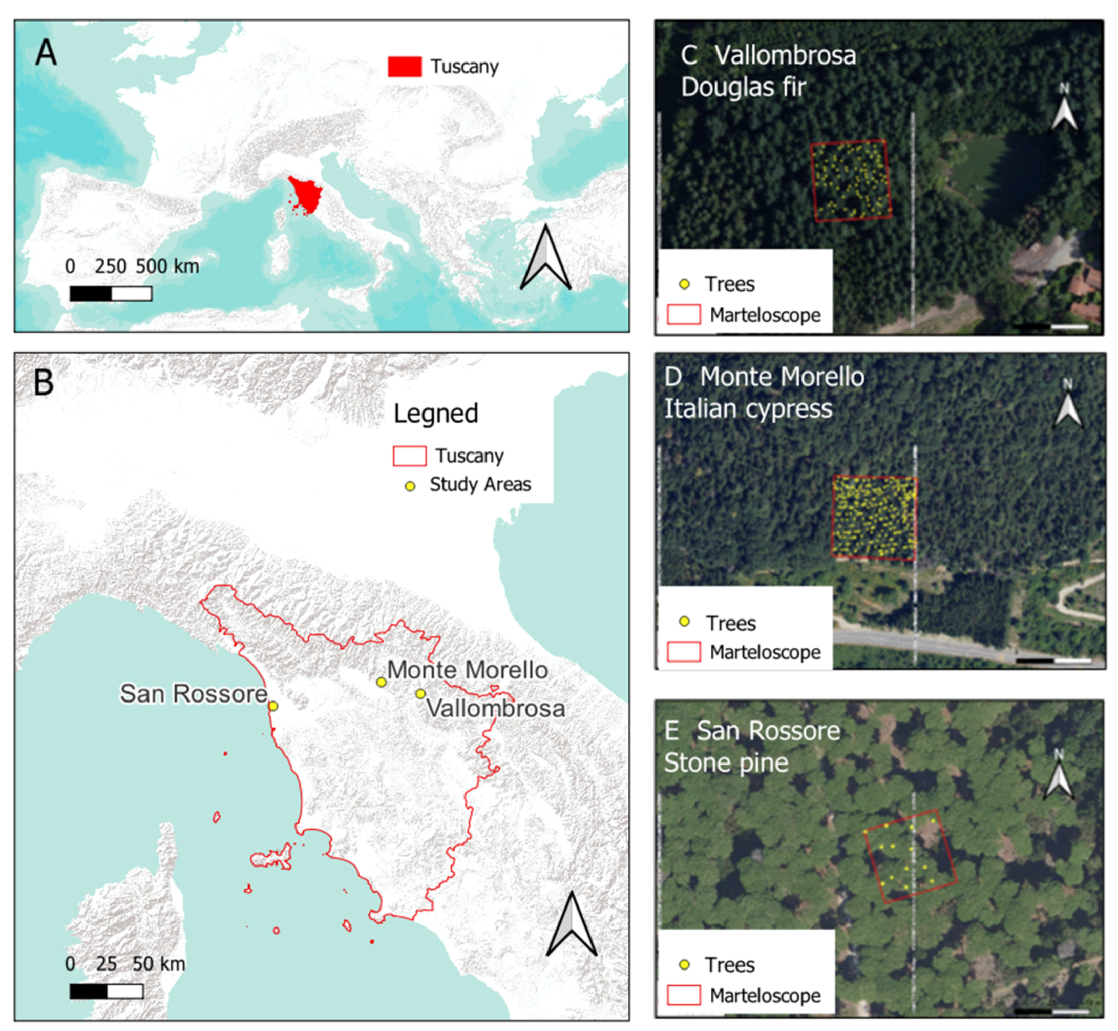
Figure 1. Panels (A,B) for the location of the Tuscany Region and the three study areas. Panels (CE) display the three marteloscopes (C) Vallombrosa; (D) Monte Morello; (E) San Rossore, including the positions of all trees overlaid on a high-resolution orthomosaic imagery.
Forests 15 02202 g001
Figure 2. Graphical representation of the MLS scan acquisition through 6 walking segments in the 50 m × 50 m marteloscope. The larger panel on the right shows the complete acquisition process.
Forests 15 02202 g002
Figure 3. Douglas-fir forest at Vallombrosa. (A,B) Top view. (C,D) Front view. (A,C) Marteloscope acquisition; (B,D) virtual marteloscope after simulated from-below thinning.
Forests 15 02202 g003
Figure 4. Stone pine forest at San Rossore. (A,B) Top view. (C,D) Front view. (A,C) Marteloscope acquisition; (B,D) virtual marteloscope after simulated gap cutting for natural regeneration.
Forests 15 02202 g004
Figure 5. Italian cypress at Monte Morello. (AD) Top view. (EH) Front view. (A,E) Marteloscope acquisition; (C,G) virtual marteloscope after simulated geometric thinning; (B,F) virtual marteloscope after simulated from-below thinning; (D,H) virtual marteloscope after selective thinning.
Forests 15 02202 g005
Table 1. Traditional versus MLS marteloscope times for data acquisition, processing, and total time. Difference = traditional—MLS.
Forest TypeTraditional MarteloscopeMLS MarteloscopeDifference Δtime
AcquisitionProcessingTotal TimeAcquisitionProcessingTotal TimeTotal Time
(hh:mm)(hh:mm)(hh:mm)(hh:mm)(hh:mm)(hh:mm)(hh:mm)
Douglas-fir 01:1400:4702:0100:1501:0301:1800:43
Italian cypress 03:2600:5104:1700:1400:5901:1303:04
Stone pine 00:5400:3901:3300:1000:4300:5300:40
Table 2. Traditional versus MLS marteloscope costs for data acquisition, processing, and total costs in euros. Difference = traditional—MLS.
Forest typeTraditional Marteloscope Cost (EUR) MLS Marteloscope
Cost (EUR)
Difference
Δcost (EUR)
Douglas-fir 142.92 38.75 104.2
Italian cypress 364.58 36.25 328.3
Stone pine 106.25 26.25 80.0
Table 3. Comparison of number of trees (N) and standing volume (GSV, growing stock volume) between traditional and MLS marteloscope in different forest types on a surface of 0.25 ha.
Forest TypeTraditional Marteloscope MLS MarteloscopeDifferences
for Density
Differences for Volume
N
(tree)
GSV
(m3)
N
(tree)
GSV (m3)ΔN
(tree)
ΔGSV
(m3)
Douglas-fir 88264.7789236.95−127.82
Italian cypress 18476.25267112.51−184−36.26
Stone pine 1366.251342.70023.55
Table 4. Method comparison in terms of error (RMSE, RMSE% and bias) for standing volume (GSV) of segmented scanned trees that matched those measured.
Forest TypeGSV RMSEGSV RMSE%GSV Bias
Douglas-fir2.971.122.69
Italian cypress2.673.510.61
Stone pine6.539.863.28
Table 5. Comparison of N and GSV for harvested trees by simulated cutting between traditional and MLS marteloscope.
Forest TypeSilvicultural OperationTraditional
Marteloscope
MLS
Marteloscope
Difference in DensityDifference in Volume
N
(tree)
GSV
(m3)
NGSV (m3)ΔN
(tree)
ΔGSV
(m3)
Douglas-fir From-below thinning 3025.163026.280−1.11
Italian cypress From-below thinning 719.70716.5703.12
Selective thinning4916.715049.32−1−32.61
Geometric thinning 6828.857636.27−8−7.42
Stone pine Gap cutting13.9613.7400.22
Disclaimer/Publisher’s Note: The statements, opinions and data contained in all publications are solely those of the individual author(s) and contributor(s) and not of MDPI and/or the editor(s). MDPI and/or the editor(s) disclaim responsibility for any injury to people or property resulting from any ideas, methods, instructions or products referred to in the content.